Climate adaptation in regional mining value chains
←
→
Page content transcription
If your browser does not render page correctly, please read the page content below
CLIMATE ADAPTATION FLAGSHIP

Climate adaptation in
regional mining value chains
A case-study of the Goldfields-Esperance Region, Western
Australia

Barton Loechel, Jane Hodgkinson, Suzanne Prober and Kieren Moffat
EP137045
July 2013

The Chamber of Minerals and Energy of Western Australia (CME) Eastern Region

Goldfields Environmental Management Group (GEMG)

                                                         Climate adaptation in regional mining value chains | i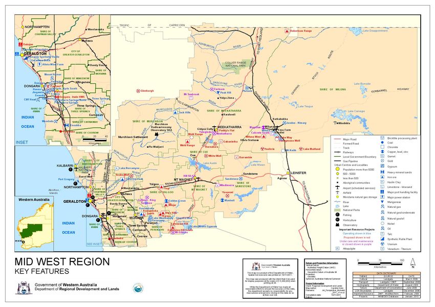
Climate Adaptation Flagship

CSIRO Earth Science and Resource Engineering

Citation
Loechel, B, Hodgkinson, JH, Prober, S and Moffat, K 2013 Climate adaptation in regional mining value
chains: A case-study of the Goldfields-Esperance Region, Western Australia. Prepared for the Chamber of
Minerals and Energy, Eastern Region, WA and the Goldfields Environmental Management Group. CSIRO
Earth Science and Resource Engineering Pullenvale, Australia. EP137045.

Copyright
© 2013 CSIRO To the extent permitted by law, all rights are reserved and no part of this publication
covered by copyright may be reproduced or copied in any form or by any means except with the written
permission of CSIRO.

Important disclaimer
CSIRO advises that the information contained in this publication comprises general statements based on
scientific research. The reader is advised and needs to be aware that such information may be incomplete
or unable to be used in any specific situation. No reliance or actions must therefore be made on that
information without seeking prior expert professional, scientific and technical advice. To the extent
permitted by law, CSIRO (including its employees and consultants) excludes all liability to any person for
any consequences, including but not limited to all losses, damages, costs, expenses and any other
compensation, arising directly or indirectly from using this publication (in part or in whole) and any
information or material contained in it.

ii | Climate adaptation in regional mining value chains
Contents

Acknowledgments .............................................................................................................................................. v
Executive summary............................................................................................................................................ vi
1           Introduction and background ............................................................................................................... 8
            1.1 Project aims ................................................................................................................................ 9
            1.2 Building on previous work .......................................................................................................... 9
            1.3 The Goldfields-Esperance region ..............................................................................................12
            1.4 The regional mining value chain ...............................................................................................15
            1.5 The WA Goldfields’ climate: past and future ............................................................................17
2           Project Methodology ..........................................................................................................................21
            2.1 Key elements.............................................................................................................................21
3           Results .................................................................................................................................................23
            3.1 Mapping of the regional mining value chain ............................................................................23
            3.2 Key climate change issues identified for the regional mining value chain from synthesis of
            interview and workshop results ..........................................................................................................26
            3.3 Cascading impacts between sectors .........................................................................................33
            3.4 Elements of viable pathways to regional adaptation ...............................................................34
4           Discussion and conclusion...................................................................................................................36
References ........................................................................................................................................................38
Appendix A            Regional mining infrastructure maps .......................................................................................40
Appendix B            Value of minerals by region ......................................................................................................43
Appendix C            The research team ....................................................................................................................44
Appendix D            Research Participant Information Sheet and Consent Form ....................................................45
Appendix E            Interview schedule ...................................................................................................................51
Appendix F            Mining value chain infrastructure ............................................................................................52
Appendix G            Workshop ‘cascading impact’ diagrams ...................................................................................54
Appendix H            Workshop Session 3b results: Adaptation Options ..................................................................63
Appendix I            Workshop Session 4 results: Barriers and enablers to adaptation ..........................................67
Appendix J            G-E region energy supply..........................................................................................................70

                                                                                                        Climate adaptation in regional mining value chains | iii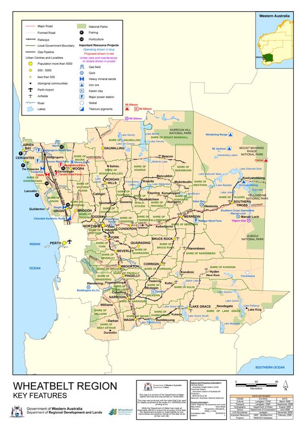
Figures
Figure 1 Goldfields-Esperance region area of study........................................................................................... 9
Figure 2 The key study areas for IOCI3 as indicated by red lines .....................................................................11
Figure 3 Western Australian regions and local government areas ..................................................................14
Figure 4 Location of major WA mining operations ..........................................................................................16
Figure 5 Climate classification of Australia .......................................................................................................17
Figure 6 Temperature trends in Western Australia. (a) Mean temperature trend over the period 1960 to
2012 in degrees Celsius per decade. (b) Mean maximum temperature trend December to February over
the period 1961 to 2011 in degrees Celsius per decade ..................................................................................18
Figure 7 Trend in annual total rainfall of WA 1950-2012 .................................................................................19
Figure 8 The 11 Australian mining regions for which CSIRO has developed climate projections out to
2030 and 2070 showing WA Goldfields (Region 4) highlighted in blue. ..........................................................19
Figure 9 Schematic map of major infrastructure arterials transecting the Goldfields-Esperance region .......24
Figure 10 Schematic outline of a typical regional mining value chain .............................................................25
Figure 11 Mining related infrastructure within the Goldfields-Esperance region of WA ................................40
Figure 12 Mining related infrastructure within the Mid West region of WA ...................................................41
Figure 13 Mining related infrastructure within the Wheatbelt region of WA .................................................42
Figure 14 WA energy infrastructure map showing the South West Integrated System (SWIS) and gas
pipelines ...........................................................................................................................................................70

Tables
Table 1 Climate statistics for different locations in the Goldfields-Esperance region .....................................17
Table 2 Projected change scenarios for temperature and rainfall in Region 4 [NCAR = National Centre for
Atmospheric Research; ECHAM = Max Planck Institute for Meteorology; GFDL = Geophysical Fluid
Dynamics Laboratory; HADGEM = Hadley Centre Global Environmental Model] ...........................................20
Table 3 Value of minerals in the Goldfields-Esperance and adjoining regions in 2011-12 ..............................43

iv | Climate adaptation in regional mining value chains
Acknowledgments

The authors thank the Chamber of Minerals and Energy, Eastern Region (CME) and the Goldfields
Environmental Management Group (GMEG), for providing funding and in-kind support to conduct this
project. In particular, we acknowledge the generous and valuable support from Linda Crook, CME, and
Wayne Astill, GEMG, for championing this project among their member organisations, introducing the
researchers to a range of industry stakeholders and aiding the research team in numerous ways in data
gathering and field research.

                                         Source: Photo: Barton Loechel

                                                                         Climate adaptation in regional mining value chains | v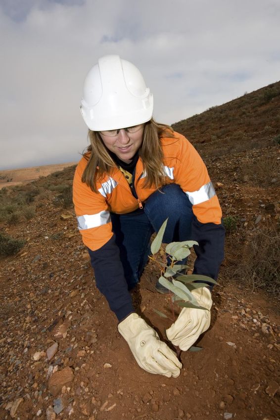
Executive summary
Climate change poses a potential range of threats and opportunities for mining regions around Australia.
Recent studies have suggested that mine operations as well as the related infrastructure, businesses and
communities associated with mining, may be affected by flooding, drought, bushfires, storms and sea level
rise.
Western Australia’s Goldfields-Esperance (GE) region is an important mineral province for Australia,
contributing an estimated $12 billion of Gross Regional Product in 2010-11. The regional mining value
chain, which also supports mining activities in the adjoining Mid-west and Wheatbelt regions, supplies a
range of mineral products, notably gold, nickel, base metals such as copper and zinc, and iron ore to both
domestic and overseas markets.
This case-study, supported by the Chamber of Minerals and Energy and the Goldfields Environmental
Management Group, sought to identify the implications of climate change for the Goldfields-Esperance
regional mining value chain.
A mining value chain approach focuses on the linkages between sectors and how impacts flow from one
area to another, providing a holistic and integrated understanding of the regional mining system.
Our analysis used a moderate-emissions scenario for future climates. Under this scenario, climate change
projections for the Goldfields region suggest that from a 1990 base level, temperatures will continue rising
to be between 0.6 to 1˚C warmer by 2030, but that annual rainfall will decline by between 5-7%,
particularly over the April-October period.
The project methodology involved desktop research and data gathering, development of regional mining
system maps to aid discussion, interviews with a broad range of regional mining value chain stakeholders,
and a workshop to test preliminary findings and extend understanding of inter-sectoral impacts and
pathways to adaptation.
The results identify key vulnerabilities and opportunities for critical mining value chain components or
sectors, the ‘spill-over’ effects or ‘cascading impacts’ between them, and potential adaptation options.
All sectors involved in this study will potentially be affected by climate change, with a clear seasonal effect
associated with the declining incidence and severity of winter storms but an increase of summer storms.
Likely impacts include:
Restraints on potable water supply from south-west Western Australia (SWWA) due to the winter
drying effect but greater local opportunities for fresh water capture in summer
Improved stability of electricity supply in winter but greater instability in summer associated with the
shifting seasonal incidence of storms
Similar shifting seasonality of disruptions to road transport and mine production from rainfall events
and to port operations from storms
Generally detrimental changes to the natural ecology of the region (from drier winters, hotter and
wetter summers, and consequent bushfires), and
Changes to the liveability of the region with milder winters but hotter and wetter summers.
The most common spill-over or cascading impacts that were identified were the effect of damage or
disruption to ‘upstream’ components of the supply chain, such as water, energy and transport, on mining
productivity and viability. These impacts then affected other components of the chain, notably human
resources (employment), the environment, and community liveability. It was also apparent that impacts on
sectors lower down the supply chain, such as ports, can have ramifications for upstream sectors. Spill-over
effects between sectors at the same level of the supply chain, notably between water and energy supply,
cascaded on to affect other sectors such as the community.
vi | Climate adaptation in regional mining value chains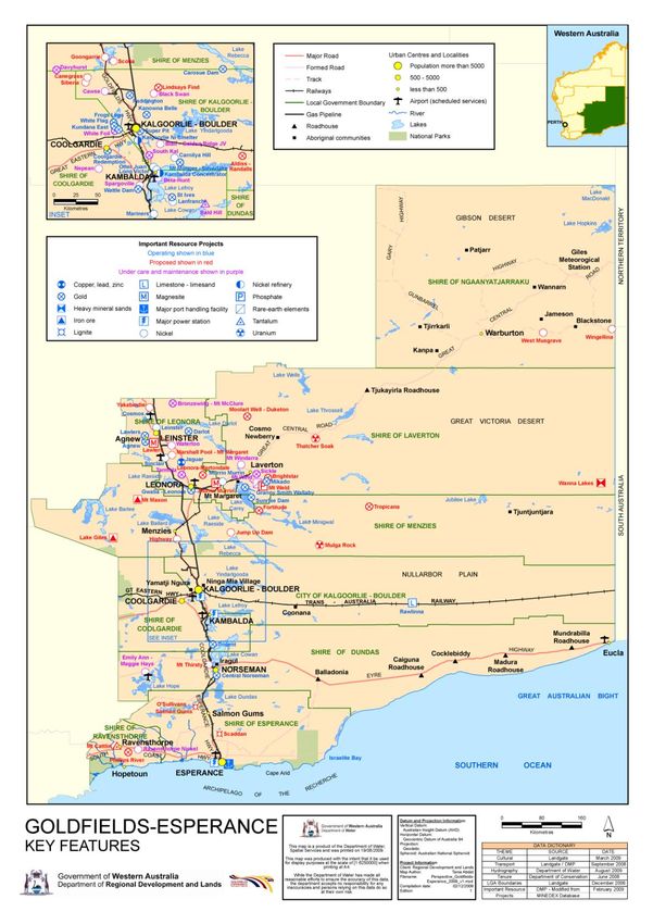
The research identified a range of factors affecting effective adaptation as well as key elements of desirable
(‘win-win’, ‘no-regrets’) and dysfunctional (‘win-lose’, ‘high-regrets’) adaptation options.
Difficulties or barriers to effective adaptation included:
Problems justifying, sharing and full accounting of the costs associated with adaptation
Uncertainty about the nature of climate change impacts, especially with regard to the investment
horizon of mines
Organisational cultural attitudes to learning and change, and
Inflexible company policies and/or government regulation.
One of the most difficult questions to answer is how costs can be shared equitably by the various
stakeholders who stand to gain or lose from the implementation of adaptation measures. For example,
improving water and energy supply security in the region, or improving the resilience of the transport
system, has benefits for multiple groups; however the primary organisation responsible for the sector or
subsector may not wish to bear the full costs because they have little way of ensuring others who benefit
will share those costs. This suggests that careful attention needs to be placed on achieving institutional
arrangements that align incentive structures to make it worthwhile for sectoral players to undertake
adaptation measures.
Key recommendations for facilitating viable pathways to climate change adaptation in a regional context
were identified as:
Develop institutional arrangements that create appropriate incentives and cost sharing for adaptation
Improve or import the expertise to identify and assess available adaptation options
Continue education and awareness raising in organisations and communities
Strategies that improve work culture attitudes to learning, change and regulatory compliance
Strategies that promote organisational leadership on adaptation and sustainability issues
Prioritise engagement and consultation at all levels to achieve responsive and flexible management
strategies and government regulation around climate adaptation, and
Ensure continual improvement of adaptation strategies through ongoing monitoring, evaluation and
review.
Climate adaptation in regional mining value chains | vii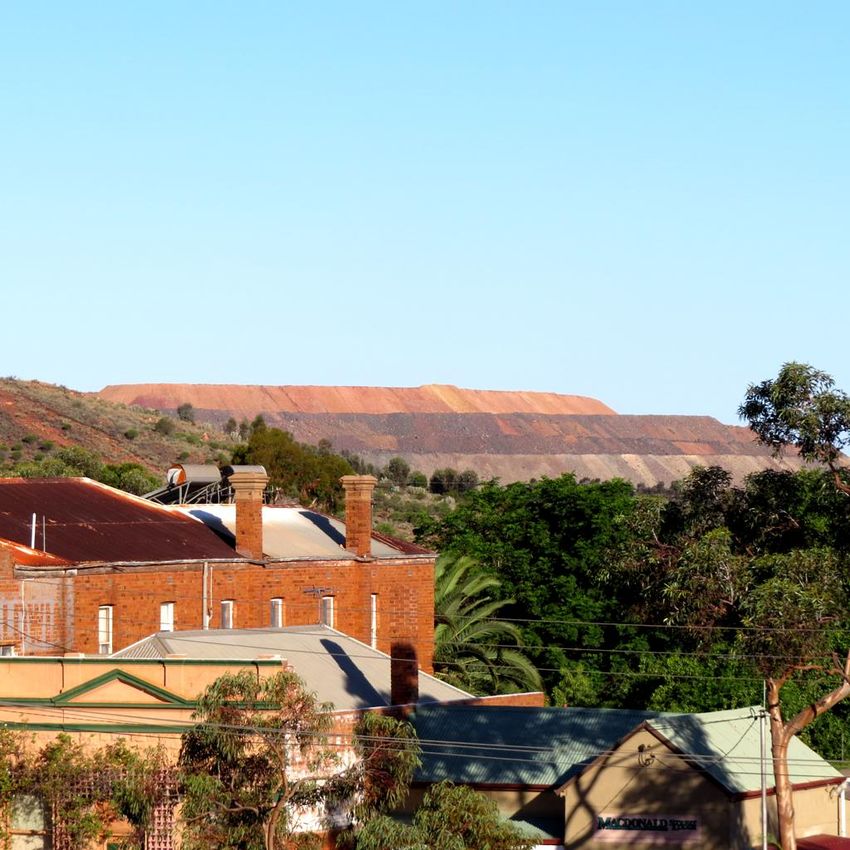
1               Introduction and background

Climate change can be an important driver of social, economic and environmental change in regional areas
of Australia and poses a range of threats and opportunities to the mining industry (Hodgkinson et al 2010;
Loechel et al 2013). Western Australia’s Goldfields-Esperance (GE) region is an important mineral province
for Australia, contributing an estimated $12 billion of Gross Regional Product (GRP) in 2010-11 (GEDC
2013). Minerals production accounted for about 70% of this, equating to 9% of Western Australia’s
minerals and petroleum value (DMP 2013).
Previous work by CSIRO investigating the likely impacts of climate change on the Goldfields-Esperance
mining region (Loechel et al 2010) identified a range of potential impacts. Impacts were identified in the
energy, water, transport, human resources, environment and community sectors. Further, one of the key
messages from this work was that many impacts were likely to cross sectoral boundaries, flowing from one
sector to another.
This mining value chain study arose out of a desire to gain a greater understanding of the cross-sectoral
impacts identified in the 2010 workshop and to explore potential adaptation options. Exploration of the
climate change impacts across the regional mining value chain, and tracing the linkages and cascading
impacts between different components of the mining industry, will be valuable in identifying viable
pathways for future climate change adaptation.
The mining value chain is conceptualised broadly and includes a range of organisations and sectors
important to the conduct of the resource industry in the region including: mining companies, mining service
providers, utility and infrastructure providers (e.g. water, power, ports), local and/or state government
agencies and community groups, and the surrounding natural environment.
The project area generally encompasses the geographic region covered by the Goldfields Esperance
Development Commission (GEDC) (see Figure 1). However, sites outside this boundary, such as those parts
of the Northern Goldfields located in the Mid West Region and iron ore projects near Southern Cross in the
Wheatbelt region, have been included for consideration as warranted by their practical relevance to the
regional mining value chain.
It is envisaged that the outputs of the study will provide a sound basis for more detailed and
comprehensive assessment by individual organisations of their own specific climate-related vulnerabilities
and adaptive capacities, within a broader regional context. Likewise these outputs will provide the basis
upon which coordinated climate adaptation planning for the region can occur. In addition, a better
understanding of the regional mining value chain adaptive capacity can be expected to contribute
significantly to the G-E region’s broader objective of sustainable development.

8 | Climate adaptation in regional mining value chains
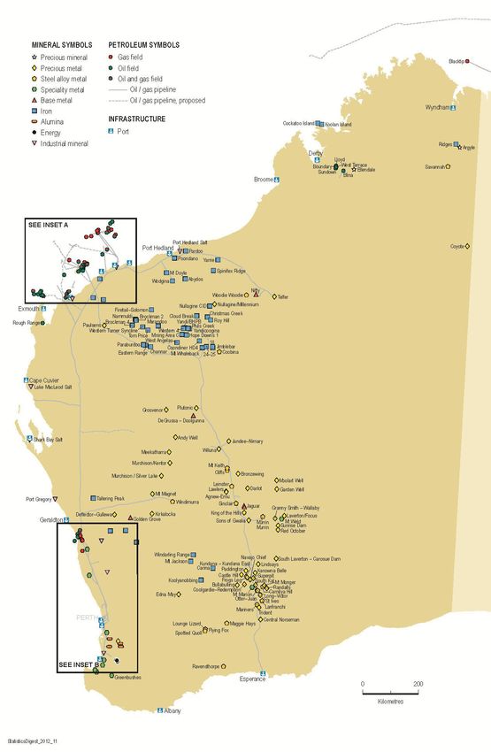
Figure 1 Goldfields-Esperance region area of study
Source: www.gedc.gov.au
1.1 Project aims
The project aims included:
Development of a framework to assess the specific vulnerabilities and adaptation options for key
sectors within the regional mining value chain
Tracing the linkages or ‘cascading effects’ between sectors under different scenarios
Engaging mining value chain stakeholders in order to strengthen this assessment of climate related
risks and implications further, using local knowledge and experience
Development of a regional mining value chain map scoping vulnerabilities and adaptive capacities
within and between sectors across the region
Identifying key elements of ‘no-regrets’ and win-win’ adaptation options, as well as those elements
more likely to lead to ‘high regrets’ or ‘win-lose’ outcomes in a regional context
Identification of key elements of viable pathways to adaptation, including barriers and synergies to
achieving meaningful adaptation in a regional context
1.2 Building on previous work
A range of recent studies have investigated potential impacts of climate change on the region and have
therefore provided useful background information to inform this project. These include the CSIRO
workshop conducted in 2010 mentioned above, the Indian Ocean Climate Initiative project Stage 3 (IOCI3),
a number of studies examining impacts of climate change on regional ecosystems, and a community water
supply study.
Climate adaptation in regional mining value chains | 9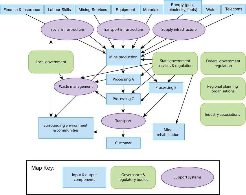
1.2.1 THE CSIRO-GEDC GOLDFIELDS-ESPERANCE REGIONAL MINING CLIMATE
VULNERABILITY WORKSHOP
In 2010, CSIRO held a regional Mining Climate Vulnerability workshop in association with the Goldfields
Esperance Development Commission (GEDC) (Loechel et al. 2010). This workshop presented climate change
projections to mining stakeholders and value chain representatives in the region and enabled discussion of
potential impacts.
Some of the major areas of vulnerability for the region identified in the workshop included: availability of
scarce resources (principally water and energy); impacts on environment and community; hazards and
workforce issues; infrastructure impacts; and mine planning and design. Factors influencing vulnerability to
climate change included: the costs, risks and returns associated with adaptation measures; societal
expectations that tend to influence government policy and regulation; and, the connections between issues
and inter-dependencies between sectors that lead to cumulative and/or compounding knock-on effects
across them.
Key adaptation needs identified by participants in the 2010 workshop included:
Access to relevant, specific and credible information, particularly that related to:
o future availability of critical resources (e.g. water and energy)
o future operating conditions for infrastructure, equipment and personnel
Knowledge and expertise relating to adaptation methods and technologies
Funds to support adaptation; and
Commitment and policy direction by government to provide impetus for action across the mining
value chain, regional communities and society more broadly.
While there were differences in sectoral vulnerabilities, needs and capacities, the various sectors were
bound by similar issues. The main issues common across sectors were dependence upon critical
infrastructure and resources, economic conditions, government policy direction, and societal expectations.
With climatic impacts in any one sector likely to have significant implications across most other sectors, it
was apparent that it would be beneficial for the different sectors to pursue open communication,
interaction and joint-planning as much as possible.
1.2.2 THE INDIAN OCEAN CLIMATE INITIATIVE STAGE 3 PROJECT - (IOCI3)
The Indian Ocean Climate Initiative (IOCI) is a partnership between the Western Australian Government,
the CSIRO and the Bureau of Meteorology, to support informed decision-making on climate variability and
change in Western Australia (IOCI 2012). It aims to provide state-of-the-art, regionally specific knowledge of
both past and projected climate trends in WA to policy makers and other stakeholders to support climate
adaptation in the state. Stage 3 of the Initiative (IOCI3), completed in 2012, performed analyses that partly
encompass the Goldfields-Esperance region. The key study areas for IOCI3 focussed on south-west Western
Australia (SWWA), basically the area south-west of a line approximately from Esperance to Northampton,
and north-west Western Australia (NWWA) (the Pilbara and Kimberley regions). While most of the
Goldfields-Esperance region lies to the north-east of SWWA and south-east of NWWA (Figure 2), the IOCI
has nevertheless provided a fundamental level of understanding of the climate systems influencing the
whole of the state. In addition, references in the study to ‘Inland’ regions and weather station data in the
Kalgoorlie area are specifically relevant to the Goldfields region.
10 | Climate adaptation in regional mining value chainsFigure 2 The key study areas for IOCI3 as indicated by red lines
Source: IOCI 2012
1.2.3 THE IMPACT OF CLIMATE CHANGE ON REGIONAL ECOSYSTEMS
Recent ecological analyses have evaluated potential outcomes of climate change for ecosystems of the
Great Western Woodlands (Prober et al. 2012) and Hummock grasslands (Smyth et al. 2013), both of which
overlap substantially with the Goldfields-Esperance region. Various modelling approaches suggest biota in
both areas will be subject to high levels of environmental stress under moderate to high emissions climate
scenarios.
One of the greatest risks relevant to mining activities identified by these studies was a high likelihood of
increasing bushfire under scenarios of increasing summer rain. Summer rains are likely to increase the
growth of summer grasses (including invasive exotics such as buffel grass, Cenchrus ciliaris), resulting in
more continuous ground fuels and potentially hotter and more frequent fires. This could result in
catastrophic fires that could transform eucalypt or Mulga woodlands to grassland or shrubland. The
potential persistence of woodlands was also expected to decrease under more extreme scenarios of rainfall
decline (potentially influencing liveability in the region). At the same time, mining-related activity was
recognised as potentially reducing the resilience of native ecosystems to climate change. Potential impacts
include exacerbation of fire risk through increased ignitions and facilitation of exotic grass invasions, and
exacerbation of moisture stress through altered hydrology (e.g. associated with roading or water
management).
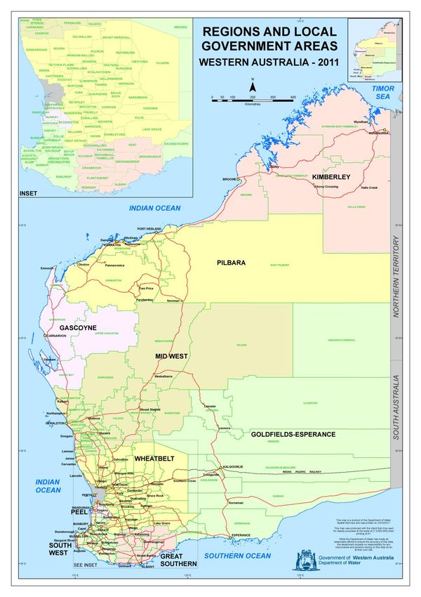
Climate adaptation in regional mining value chains | 111.2.4 STUDY OF RESILIENCE AND WATER SECURITY IN OUTBACK CITIES Another relevant community water supply study (Albrecht et al 2010) investigated the views of the residents of Kalgoorlie regarding the future (year 2070) of the town and region under different scenarios. The scenarios incorporated a number of variables, notably climate change, mining industry prospects, government interventions and technological development. The study found that residents had a generally optimistic view of the future of the region, believing that while water supply may become more restricted, advances in technology would solve many of the problems a changing climate may bring. The study contrasted the situation of Kalgoorlie with that of Broken Hill and suggested that the culture of optimism that tends to pervade the mining sector can result in resistance to serious consideration of climate adaptation issues. 1.3 The Goldfields-Esperance region The Goldfields-Esperance (GE) region is vast in area (771,276 km2) covering just under one third of Western Australia’s land mass and has a diverse ecology, encompassing desert, temperate eucalypt woodlands and coastal national parks. It is the largest of Western Australia’s nine regions and over three times the size of the state of Victoria. The GE region is bounded by the Pilbara Region and Gibson Desert to the north, the Wheatbelt and Mid-West regions to the west and north respectively, the Great Southern Region to the south-west, the Southern Ocean and the Great Victoria Desert, the Nullarbor Plain and the South Australian border to the east (Figure 3). The region’s population is approximately 57,500 according to the 2011 Census (ABS 2013) and is projected to rise to 62,200 by 2026 (GEDC 2012). The regional population is predominantly located in the major towns of Kalgoorlie-Boulder and Esperance, with the remaining population being situated in many smaller, rural and remote towns and settlements in the region. In 2011, 5,328 people identified themselves as Aboriginal, representing 9.3% of the total regional population (ABS 2013). The dispersed and remote population centres can create challenges for provision of services and coordination of planning to attract investment for infrastructure (GEDC 2012). In 2011, the largest employer was the mining industry, which employed 27% of the region’s workforce followed by retail trade (7.5%) and manufacturing (7.1%). Construction, health care and education were the next most significant employment areas (6.8%, 6.5% and 6.4% respectively). Minerals account for 71% of gross regional product. In 2011-12 this equated to $9.2 billion in value and represented 9% of Western Australia’s minerals and petroleum value (DMP 2013). The region is characterised by a wide range of vegetation types, varying as rainfall declines from the south- west to north-east, and with more localised soil patterns (Beard 1990). Diverse, fire-prone scrub-heath and mallee-heath predominate in the more coastal, south-western parts. These are adjoined to the north by mosaics of eucalypt woodland, shrubland and mallee of the globally significant ‘Great Western Woodlands’. These include some of the largest tracts of the world’s remaining temperate woodlands, and over 25% of Australia’s eucalypt species (Watson et al. 2008). The Great Western Woodlands are bound to the north by the ‘Menzies line’, where eucalypt woodlands give way to the Casuarina and Acacia (particularly Mulga, A. aneura sens. lat.) woodlands and hummock grasslands (Triodia spp. or spinifex) that characterise the northern parts of the region. The hummock grasslands may also support scattered eucalypts, particularly Eucalyptus gongylocarpa. The region also includes chenopod shrublands of the Nullarbor Plain (Beard 1990). Only the south-western parts of the region have been cleared for intensive agriculture, with resultant fragmentation and degradation of native vegetation. Extensive pastoralism is the more predominant agricultural landuse, influencing the condition of many of the chenopod shrublands, Acacia woodlands and eucalypt woodlands. While in the early years of the mining industry significant areas of the Great Western Woodlands were cut for timber (3 million of the total 16 million hectares (19%) of the GWW is estimated to have been cleared) much of this area has since recovered to varying degrees (DEC, undated). However, 12 | Climate adaptation in regional mining value chains
significant areas of woodland, mallee and shrubland have remained largely unexploited for livestock
grazing, agriculture or timber, and are globally significant from a biodiversity conservation perspective
(Watson et al. 2008).
The region’s landscape includes long, shallow salt-lakes, gentle hills and low ranges with gum woodlands on
the Kalgoorlie Plain through to treeless plains and flat, arid topography in the Nullarbor, and low-heath
remnant vegetation with salmon gum and Wheatbelt plateau (cropping and livestock) on the Esperance
Plain. Additionally, the Meekatharra Plateau, characterised by gently undulating plains, and low, rugged
ranges and hills has a diverse vegetation mix, whilst the deserts north of Nullarbor and east of the
Meekatharra plateaux have linear sand ridges, hummocky grass and Spinifex (Western Australian Planning
Commission 2000). The greatest proportion of land in the region is described as being for ‘other minimal
use’, with other uses including grazing, cropping, nature conservation, water bodies, some forestry, mining
and urban use.
Geologically, there are five main geological and structural units: the Yilgarn Craton is the oldest and consists
of Archaean age granite, gneiss and volcanic and sedimentary rocks; the Musgrave Block and the Fraser
orogen are of both metamorphosed and unmetamorphosed sedimentary and volcanic rocks of early to mid
Proterozoic age; the Officer Basin of relatively undeformed and unmetamorphosed sedimentary rocks of
Proterozoic to Mesozoic age; and the Eucla basin comprising of limestones of tertiary age. During the
humid Cretaceous period, deep, chemical weathering of soils to depths of 50 metres occurred resulting in
infertile soil later, during the drier Oligocene turning to a hard, laterite crust. Sand over the laterite is
believed to have formed during the Ice Age 15-18,000 years ago when the climate was cool, dry and windy.
In all areas, soils are typically highly weathered and lacking in nutrients, vulnerable to wind and water
erosion and calcrete and laterite is common (Western Australian Planning Commission, 2000).

                                                                     Climate adaptation in regional mining value chains | 13
Figure 3 Western Australian regions and local government areas 14 | Climate adaptation in regional mining value chains
1.4 The regional mining value chain
The regional mining value chain includes a range of organisations and sectors that are important to the
resource industry in the region. These include mining companies, mining service providers, utility and
infrastructure providers (e.g. water, power, transport), local and/or state government agencies and
community groups, the surrounding environment and the mineral resources it contains.
There is considerable mining infrastructure across the region, from actual mines, through to mineral
processing plants, utilities and transport infrastructure.
Figure 4 displays the major mining projects in the region. The main minerals produced are gold, nickel and
base metals. The adjoining Wheatbelt and Mid-west regions also produce considerable quantities of iron
ore, gold and base metals (see Appendix A for location of major mining projects in these regions; Appendix
B for the value of mineral commodities by region). Mineral production in these adjoining regions has
relevance to the Goldfields-Esperance mining value chain because some iron ore and nickel products in
particular are transported via the Goldfields-Esperance region’s transport infrastructure and are also reliant
on mining services located within the region.
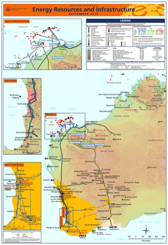
Climate adaptation in regional mining value chains | 15Figure 4 Location of major WA mining operations Source: WA Dept Mines & Petroleum 2011 16 | Climate adaptation in regional mining value chains
1.5             The WA Goldfields’ climate: past and future
The Goldfields-Esperance region’s climate classification ranges from ‘desert’, to the north and east of
Kalgoorlie-Boulder, through ‘grassland’, south of the city, to ‘temperate’ in the coastal areas around
Esperance (based on the Köppen classification system; see Figure 5). As such, the northern and western
areas of the region experience much hotter and drier conditions than the southern and particularly coastal
areas (see Table 1).

Figure 5 Climate classification of Australia

Source: BOM 2013a

Table 1 Climate statistics for different locations in the Goldfields-Esperance region

 CLIMATIC VARIABLE                           ESPERANCE              KALGOORLIE-                LEINSTER                     WARBURTON
                                                                    BOULDER
 Mean Maximum Temperature                    21.9°C                 25.2°C                     28°C                         29.7°C
 Mean number of extreme hot days             2.5                    9                          22.6                         34.6
 per year (≥ 40˚C)
 Mean number of frost days (≤ 0˚C)           0                      3.9                        1.1                          4.2
 Mean annual rainfall (mm)                   618.3                  266.7                      263.3                        249.3
 Seasonal rainfall pattern                   Winter                 Fairly evenly spread,      Summer dominant              Summer dominant
                                             dominant               least in Spring
 Mean wind speed (km/h)                      24.5                   15.9                       17.8                         16.4

Source: Table compiled from monthly climate statistics, BOM 2013b

1.5.1 HISTORICAL TRENDS

Temperature
Similar to the annual mean temperature trend for Western Australia overall, mean temperatures in the
Goldfields-Esperance region have increased around 0.9˚C over the last 50 years (Figure 6a). However, mean
maximum summer temperature trends have been more variable across the region over this period. While
central parts of the region (roughly corresponding to the Goldfields) have warmed slightly, southern areas
on or close to the coast, as well as eastern areas extending over and to the north of the Nullarbor Plain,
have cooled (Figure 6b; IOCI 2012).

                                                                                            Climate adaptation in regional mining value chains | 17
Figure 6 Temperature trends in Western Australia. (a) Mean temperature trend over the period 1960 to 2012 in degrees Celsius per decade. (b) Mean maximum temperature trend December to February over the period 1961 to 2011 in degrees Celsius per decade Source: a) BOM 2013c; b) IOCI 2012 Rainfall The south-west of Western Australia (SWWA), including the G-E region, has experienced a large reduction in winter and autumn rainfall over the last sixty years (IOCI 2012). This is largely attributed to increased stability of the atmosphere during this period over this area, due to changes in atmospheric circulation and thermal structure, producing a decline in frequency and intensity of winter storms (IOCI 2012). At the same time, there has been an observed southward expansion of tropical weather systems, resulting in increased summer storm activity and rainfall. The net effect for the G-E region has been a slight increase in mean annual rainfall over this period, with the greatest increases experienced in the north-eastern parts of the region (Figure 7). Other observations Since the early 1990s, the southern coast of WA has experienced sea level rise in the order of 5.3 millimetres per year, somewhat higher than eastern Australia (2-3mm/yr) but lower than Fremantle (8.6 mm/yr) and north-west WA (8.1mm/yr) (McEvoy et al 2013). This represents acceleration from the historical trend, where sea level around Australia is observed to have risen about 17 centimetres between 1842 and 2002, equivalent to a rate of 1.2 millimetres per year (Church et al 2008). As yet there have been no clear or consistent trends observed in coastal or inland wind speeds for this region (Troccoli et al 2011). 18 | Climate adaptation in regional mining value chains
Figure 7 Trend in annual total rainfall of WA 1950-2012
Source: BOM 2013c
1.5.2 FUTURE CLIMATE PROJECTIONS
Climate projections (changes in monthly temperatures and rainfall from a 1990 baseline) have been
developed by CSIRO for 2030 and 2070 for key Australian mineral provinces displayed in Figure 8. Region 4
on this map corresponds with the main mining areas of the WA Goldfields. The regional level projections
were developed using novel statistical downscaling methods (Kokic et al. 2011) utilising four of the best
performing climate models for the Australian region, based on model ability to predict observed historical
change. The projections are based on a single emission scenario ‘A1B’ representing a “middle-of-the-road”
view of future greenhouse gas emissions growth (Crimp 2010).
Kalgoorlie
Figure 8 The 11 Australian mining regions for which CSIRO has developed climate projections out to 2030 and 2070
showing WA Goldfields (Region 4) highlighted in blue.
Source: Loechel et al. 2010
Climate adaptation in regional mining value chains | 19The specific temperature and rainfall projections for the region are displayed in Table 2. They suggest that
by 2030 future climate conditions for Region 4 are predicted to be between 0.6 to 1˚C warmer and 5 to 7%
drier, particularly in the May-October period, compared to the 1990 baseline. While it is apparent that the
projected temperature increase is a continuation of observed historical trends, the projected rainfall
decline by 2030, particularly in the November to April period, is in contrast to the overall (mainly summer)
trend towards wetter conditions observed in the region over the past 60 years. It is unclear whether this
difference between observed and projected rainfall trends is due to the climate models underestimating
the expansion of rain bearing tropical influences on the region due to anthropogenic warming, or to shorter
term fluctuations in the normal climatic cycles that influence regional rainfall.
Table 2 Projected change scenarios for temperature and rainfall in Region 4 [NCAR = National Centre for
Atmospheric Research; ECHAM = Max Planck Institute for Meteorology; GFDL = Geophysical Fluid Dynamics
Laboratory; HADGEM = Hadley Centre Global Environmental Model]
Projected changes in temperature and rainfall REGION 4
SOURCE: NCAR NCAR ECHAM ECHAM GFDL GFDL HADGEM HADGEM
Temp °C Rain (%) Temp °C Rain (%) Temp °C Rain (%) Temp °C Rain (%)
November to April 2030 1.09 4 1.09 -1 1.16 -5 0.93 -4
May to October2030 1.14 -6 1.09 -6 1.02 -5 0.76 -5
November to April 2070 2.96 10 2.96 -2 3.13 -14 2.52 -12
May to October 2070 3.07 -16 2.46 -15 2.76 -47 2.07 -13
Source: http://www.csiro.au/ozclim/home.do
Sea level rise
Detailed sea level rise projections have not been performed for the different coastal zones around Australia
for the 2030 and 2070 timeframes. The Intergovernmental Panel on Climate Change (IPCC) has estimated
global sea-level rise of between 18-59 centimetres and potentially as high as 79 centimetres by 2100 (CSIRO
and BoM, 2007), while others have suggested that a rise of more than 1.0 metre and as high as 1.5 metres
cannot be ruled out, depending on different emissions and ice sheet melting scenarios (Steffen 2009, cited
in DCC 2009).
20 | Climate adaptation in regional mining value chains2 Project Methodology
2.1 Key elements
This study sought to develop a greater understanding of the likely impacts of climate change on the
regional mining value chain, particularly in terms of linkages and cascading impacts between sectors, and in
light of this, to identify potential measures and pathways to adaptation. The key elements of the project
methodology were as follows (see Appendix C for list of research team members):
1. Provision of relevant background information
2. Collating and developing a preliminary set of maps of mining projects and key infrastructure in the
Goldfields-Esperance region to build knowledge of the regional mining value chain and assist interview
and workshop discussions
3. Conducting interviews with organisations across a broad range of regional mining value chain sectors
to identify current linkages across and between sectors and key vulnerabilities and adaptation
measures
4. Conducting a workshop with these stakeholders in the region to test and validate preliminary findings,
discuss the regional mining value chain climate adaptation issues collectively, and build new knowledge
5. Qualitative analysis and synthesis of data for reporting.
2.1.1 BACKGROUND INFORMATION
The CSIRO-GEDC Regional Mining Climate Vulnerability Workshop report (Loechel at al 2010) was initially
provided as background information to the project sponsors. This report together with the preliminary
infrastructure mapping report (Loechel 2013; also see below), which provided a range of maps and
background information on this research project, were provided to confirmed interview participants prior
to interview. Confirmed workshop participants were also sent the preliminary infrastructure mapping
report (Loechel 2013) prior to the workshop.
2.1.2 MAPS
The preliminary infrastructure mapping report “GE region mining value chain infrastructure maps” (Loechel
2013) collated a range of publicly available maps displaying mining projects and related infrastructure in
the Goldfields-Esperance and adjoining regions in Western Australia (Appendix A). This report also included
two regional mining value chain maps/diagrams developed as part of this research:
A succinct overview of the location of key infrastructure important to the regional mining value chain
(see Figure 9 for final version)
A schematic depiction of a typical mining value chain adapted to the particular institutional
arrangements of the GE region (see Figure 10 for final version)
The preliminary mapping report was circulated for discussion and validation to the project sponsors and
interview and workshop participants as described above.
Climate adaptation in regional mining value chains | 212.1.3 INTERVIEWS
Key organisations relevant to the regional mining value chain were identified as potential participants for
interviews. Potentially relevant organisations and individuals (organisation representatives) were identified
using both information gleaned from the regional mining value chain mapping exercise and information
supplied by the project sponsors. These organisations and/or individuals were then sent an email inviting
participation in interviews, together with an Interview Participant Information Sheet and Consent Form
(see Appendix D).
Twenty semi-structured interviews were conducted in February-March 2013, representing 20 different
organisations and involving a total of 23 consenting participants. Organisation representatives interviewed
were from the following sectors: mining companies/industry, energy (electricity, gas, renewables), water,
transport (roads, rail, port), environment, local government, state government, community, and regional
development.
Most interviews were conducted face-to-face in Kalgoorlie-Boulder; four interviews were conducted by
telephone. Prior to interviews, participants were provided with both the preliminary infrastructure
mapping report (to further test and/or validate these maps) and the 2010 CSIRO-GEDC workshop report to
inform the discussion. The interviews sought organisation level information on:
mining value chain vulnerabilities and adaptive capacity
key relationships, including dependencies and effects on other supply chain participants
perceived barriers to, and enablers of, climate change adaptation
The interview schedule is provided in Appendix E.
2.1.4 WORKSHOP
A workshop was conducted in Kalgoorlie-Boulder on 23rd April 2013 to test and discuss preliminary findings.
Workshop participants were recruited both from the list of identified organisations and organisation
representatives invited for interview, as well as from a broader list of potentially relevant organisations,
mainly developed from information provided in these interviews. A total of 22 regional mining stakeholders
participated in the workshop, of which eight had participated in an interview and a further seven were from
organisations that had participated. The participants therefore comprised a very similar range of
organisations and sectors as the interviews.
The principal aims of the workshop were to test and validate preliminary findings and to build new
knowledge, particularly with regards to identifying:
Cascading climate impacts between sectors
Key elements of viable regional pathways to adaptation, notably win-win and win-lose adaptation
options, and barriers and enablers to synergistic adaptation.
Workshop information was recorded via written notes of whole group discussions and presentations and
diagrams and notes recorded by small group discussion on large sheets of ‘butchers paper’. Specifically
designed information recording documents were also used for particular sessions.
2.1.5 DATA ANALYSIS & REPORTING
All data was analysed using qualitative techniques, such as narrative analysis and coding for themes, to
identify key issues. As described above, early project findings were reported and tested both at interviews
(in the case of the preliminary mapping report) and the workshop (in the case of interview findings). This
report represents the synthesis of the workshop results with these earlier findings.
22 | Climate adaptation in regional mining value chains3 Results
3.1 Mapping of the regional mining value chain
The regional mining value chain is supported by a range of critical infrastructure, of which the most basic
are depicted in schematic form in Figure 9. Detailed geographic maps of the mining infrastructure
supporting the Goldfields- Esperance and adjoining regions are provided in Appendix A. Key infrastructure
components are described in more detail in Appendix F, of which the key sectors can be categorised as:
Energy: primarily an electricity grid, the South West Integrated System (SWIS) utilising coal and wind
resources; a gas pipeline from the north-west gas production area; diesel fuelled generators; and small
solar systems
Water: pipeline of potable water from Mundaring Dam near Perth; treated groundwater; saline and
hyper-saline water sourced on mine sites
Transport: road, rail, seaports and airports
Telecommunications: telephone and internet services
Social and community infrastructure: health, education, recreation, law and order, waste management
and other facilities
Environment: landforms, water courses, soil, native flora & fauna.
Climate adaptation in regional mining value chains | 23Figure 9 Schematic map of major infrastructure arterials transecting the Goldfields-Esperance region 24 | Climate adaptation in regional mining value chains
The structure of the regional mining value chain is depicted in Figure 10. This figure depicts three main
components: inputs and outputs, support systems, and governance/ regulatory institutions. The support
systems roughly equate to the infrastructure assets supporting the mining value chain. The resulting map
shows a flow of inputs (e.g. energy, water, materials, labour, etc) through their corresponding
support/infrastructure systems (e.g. electricity grid, water pipeline, transport systems), as influenced or
regulated by a range of government and non-government institutions. The outputs of the chain are
primarily of two types: mineral products for sale to customers and waste products to be treated before
release to the surrounding environment.

Figure 10 Schematic outline of a typical regional mining value chain

                                                                       Climate adaptation in regional mining value chains | 25
3.2 Key climate change issues identified for the regional mining value
chain from synthesis of interview and workshop results
Analysis of interview and workshop data identified a number of key issues arising from climate change for
the regional mining value chain. These are summarised below in terms of the impacts that the most
important climatic change effects (e.g. heat, rainfall, wind, etc) may have on the main infrastructure
systems supporting the regional mining value chain (energy, water, transport, mine production and
processing, environment and community).
Diagrammatic representations of the climate change vulnerabilities, impacts and adaptation options
produced by workshop participants for the various sectors are displayed in Appendix G.
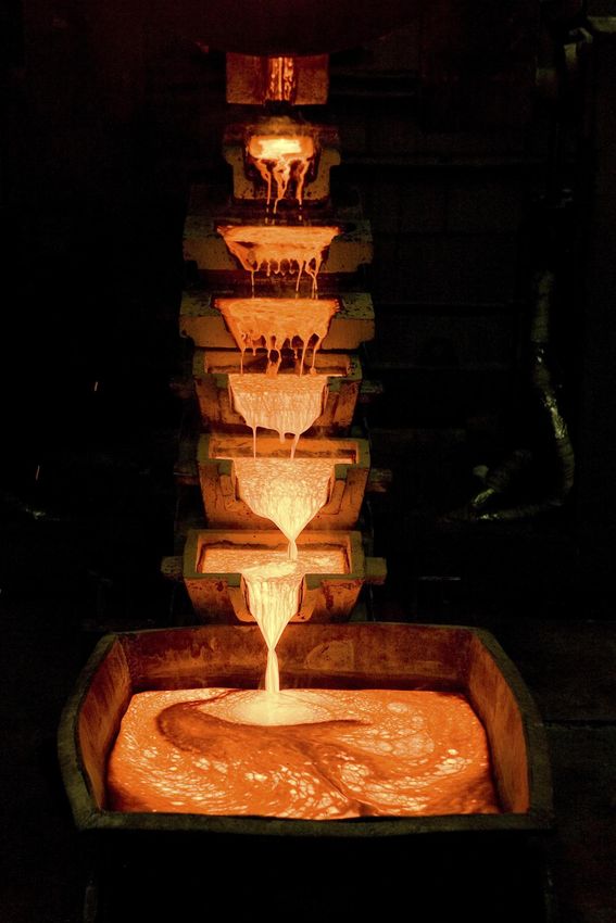
Source: Norton Gold Fields; Photo: Greg Tossel
26 | Climate adaptation in regional mining value chains3.2.1 ENERGY
For energy supply there is a clear seasonal differentiation in risk arising from climate change. Projected
future summer storms, rainfall events, and hotter temperatures will likely increase energy demand and
potentially damage energy infrastructure as well as infrastructure that support energy generation (e.g.
roads for diesel transport). By contrast in winter, it is likely that as temperatures will be warmer and storms
less frequent and intense, risk to energy related infrastructure and services will be lower. This could
potentially see a gradual but asymmetrical seasonal shift in system risk weighting, declining somewhat in
winter and increasing in summer.
Key adaptation options identified included upgrading the electricity grid (SWIS) infrastructure to prevent
faults, improving capacity to isolate fault location to prevent impacts on the rest of the grid, and improving
the capacity of redundant and backup systems in case of faults (e.g. solar/diesel hybrid generators). A
greater reliance on gas was also suggested as the supply pipelines are less vulnerable to extreme weather
events.
ENERGY IMPACTS
Temperature Hotter summer conditions are expected to potentially:
– increase demand for energy: cooling requirements and water pumping (e.g. for mine
dust suppression, and town parks and gardens)
– reduce electricity transmission/supply efficiency (SWIS)
– overheat transformers leading to thermal overload, faults and blackouts
– increase power line sag
Increased incidence of summer storms increases wind gusts and lightning strikes and both
increase the likelihood of electrical faults and bushfires
The combination of increased electricity demand and increased incidence of electrical
faults in summer may reduce security of summer electricity supply through the SWIS
Winter demand and faults expected to decrease due to warmer temperatures and fewer
projected winter storms
Rainfall Limited impact on power lines, and SWIS grid infrastructure, from intense rainfall
Gas pipeline is also well protected from intense rainfall events because it is buried
– erosion from extreme flooding from increased cyclone intensity projected for the
north-west region of WA could expose the gas pipeline to damage
Supply of diesel to remote mines may be disrupted by increasing summer rain, although
the opposite is expected in winter due to the winter drying trend
Drying of south-west WA (SWWA) may increase sea-water desalination and groundwater
pumping energy demands there, indirectly increasing pressure on electricity supply to the
G-E region through the SWIS
Other Solar energy seen as a ‘complementary’ resource as its productivity increases in summer
when energy demand increases
SWIS systemic vulnerability affects all energy sources (coal, gas, diesel, wind, solar)
Spill-over Faults/disruption to energy supply affects mines, mining services (e.g. town based
engineering firms), telecommunication, and community: they can cascade through the
system to affect business profitability, employment and community liveability
Many mines have back-up diesel generators in the case of disruption to electricity supply,
as do many towns; may need upgrading for future increased summer storms
Fighting bushfires sparked from electricity faults can be complicated by the fact the
electricity supply to water pumps can be affected
Climate adaptation in regional mining value chains | 273.2.2 WATER
In general, apart from mines located within reach of the Goldfields Water Supply Scheme (GWSS), most
mines rely heavily on groundwater, which varies widely in quality from hyper-saline in central parts of the
Goldfields region around Kalgoorlie-Boulder to relatively fresh (low salinity) in areas accessing the Officer
Basin in the north of the region. Those mines whose groundwater supply is hyper-saline rely on capturing
runoff, importing water or desalination (where feasible) to meet their fresh water needs.
Key adaptation options identified included increasing water use efficiency, notably: the use of ‘fit-for-
purpose’ water to avoid unnecessary use of high quality water; reuse of water from one process and/or
sector to another (e.g. the community sells treated waste water to the mines for their fresh – but non-
potable – water needs); and, recycling water (e.g. mines recycle their process water a number of times).
Other opportunities identified included: greater storm water capture; strategic storage of water of different
types (potable, fresh, saline, recycled); identifying and exploiting additional sources of water where cost
effective and environmentally acceptable (e.g. piping low saline groundwater from Eucla and/or Officer
Basins); and desalination.
WATER IMPACTS
Winter A large proportion (around 45%) of GWSS potable water supply is used for mining
drying trend Potential for severe pressure on potable water supply to the Goldfields region. Mundaring
Dam decline would mean less available water, affecting GWSS supply security/price
Winter drying is likely to affect fresh water supply to those mines and communities that
rely on winter rainfall capture (summer wetting trend may offset this considerably)
Region’s natural ecology affected: systems traditionally reliant on higher winter rainfall
such as the Great Western Woodlands, pastoral industry, and mine site rehabilitation
Summer Provides greater runoff and fresh water capture opportunities for communities and mines
wetting – water supply increased at time of greatest need for dust suppression and community
trend parks and gardens: potential offset of future warmer summers
Wetter summers may be detrimental to the natural ecology
– pest species (e.g. Buffel Grass) invade southward, increasing summer fuel load and fire
risk to areas such as the GW Woodlands that are poorly adapted to frequent bushfires
– intense rainfall events also increases erosion of exposed landscapes
Spill-over Similar to the energy system, reduced water supply can affect a broad range of sectors,
including mines, mining services, and community. These effects can cascade through the
system to affect business profitability, employment and community liveability
Increased requirement to pump or desalinate water as supply becomes restricted can
increase energy demand, impacting the energy system
Increased incidence of summer storms can spark bushfires, increasing demand for water
pumping, however in addition to the complications from electrical faults noted above,
intense rainfall from these storms can also cause erosion that compromises water supply
pipelines, also hampering bushfire fighting
Use of more saline water and/or desalination of saline water increases risks from release
of saline waste to the environment
28 | Climate adaptation in regional mining value chainsYou can also read