Cloud Guide SpoTTinG - BBC
←
→
Page content transcription
If your browser does not render page correctly, please read the page content below
Cloud
            spotting
              guide

The Great British Weather – Cloud Spotting Guide   i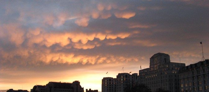
Welcome
                      The Great British Weather
                      Team have put together this
                      guide. We hope it will help you
                      identify those different fluffy
Alexander Armstrong
                      (and not so fluffy) objects
                      in the sky.
                      Even if you’ve never tried cloud spotting
                      before, get started with our easy-to-use
                      cloud manual. Once you think you know
Carol Kirkwood        your Cumulus from your Cumulonimbus why
                      not use the cloud spotter score card which
                      rates the top ten clouds to spot. Can you
                      spot all ten?
                      There are more things to discover about the
                      weather at bbc.co.uk/greatbritishweather,
                      including “How to” videos on building
Chris Hollins         a rain gauge and understanding weather
                      terminology.
                      There’s also a safety guide for taking
                      photographs of the weather (mostly
                      common sense of course), but worth a look.
                      You can get involved with the production
                      too by sending your best snaps to
                      greatbritishweather@bbc.co.uk and they
                      may be broadcast live on the BBC One
                      show, on our special BBC Weather galleries
                      or on a live weather forecast.
                      And don’t forget to join in the weather
                      banter @BBCbritweather and #BBCgbw
                      from now till 5 August 2011.
                      Happy cloud spotting!

 ii                        The Great British Weather – Cloud Spotting Guide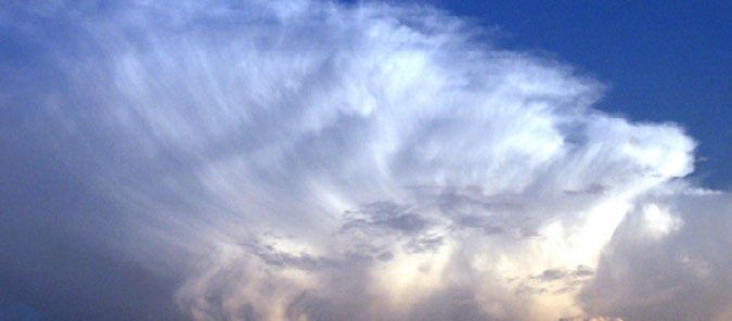
Introduction
                                  Clouds are made of water –
                                  tiny droplets of water in the
                                  case of the low clouds and ice
                                  crystals in the high clouds
                                  (mid-level clouds often contain
                                  a mixture of the two).
                                  There are ten basic types of cloud and they
                                  are grouped according to the way they look
                                  – whether they’re made up of individual
                                  clumps, or layers or streaks – and how high
                                  they are – whether low, mid-level or high
                                  clouds. The ten types are divided up into
                                  many other species and varieties.
                                  This guide contains just a few of the many
                                  different cloud types – some common and
                                  easy to spot, some rare. You never know
                                  when an interesting formation is going to
                                  appear, so always keep an eye on what is
                                  happening above.

bbc.co.uk/greatbritishweather
The Great British Weather – Cloud Spotting Guide                               1
1. Cumulus

 Cumulus                                                 Cumulus – Inverness

What to look for
Cumulus clouds are the cotton wool puffs, with
flat bases and cauliflower tops, which drift lazily
across the sky on a sunny day. They generally
form a few hours after daybreak and tend to
scatter before sundown. They form on invisible
columns of air (known as thermals) which rise
from the ground as it is warmed by the Sun.              Cumulus humilis
Most forms of Cumulus produce no rain or snow,
and so are known as fair-weather clouds. When
a Cumulus is fraying at the edges as it breaks         Key facts
up, having reached the ripe old age of 15              If you were to add
minutes or so, it is known as Cumulus fractus.         together all the
What they mean for us                                  droplets in a medium
The smaller Cumulus humilis never produce              sized Cumulus cloud,
any rain or snow, but large Cumulus clouds             they’d weigh the same
can produce light to moderate showers.                 as 80 elephants.
When Cumulus build upwards through the
morning they’re a warning of heavy showers
by the afternoon: ‘in the morning mountains,
in the afternoon fountains’.
                                                                  60

                                                           Cloud points
                                                          (because they are easy
                                                              to recognise)

 2                                  The Great British Weather – Cloud Spotting Guide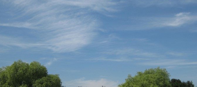
2. Stratocumulus

  Stratocumulus – Culbin                              Stratocumulus

 What to look for
                                                     Key facts
 The most widespread of all cloud types in the
                                                     Sometimes you
 UK, as well as many other regions of the world,
                                                     can see fingers of
 Stratocumulus is a low layer or patch of cloud
                                                     sunlight shining down
 that has a clumpy base. The patches are either
                                                     through breaks in a
 joined up, or have gaps in between. When the
                                                     Stratocumulus cloud.
 sky is overcast with a cloud base that appears
                                                     These are known as
 to be low and the tones of the cloud vary from
                                                     ‘crepuscular rays’.
 white to darker grey, you can be confident that
 you are looking at a Stratocumulus.
 What they mean for us
 Stratocumulus clouds do sometimes produce
 rain or snow, but this is generally quite light.              30
 Their main effect is of blocking out our beloved
 sunshine. Often in the UK, Cumulus clouds can         Cloud points
 become more and more plentiful through the              (because they are
 morning, spreading out and joining together               so common)

 into a Stratocumulus layer that covers the sky.

“My favourite cloud is the cumulus as it normally
  means we can expect fair weather. Those white
  puffy clouds in a blue sky on a summer’s day are
  a view hard to beat.”
 Carol Kirkwood

 The Great British Weather – Cloud Spotting Guide                            3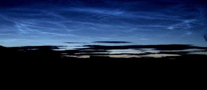
3. Cumulonimbus

  Cumulonimbus                                              Cumulonimbus

What to look for
                                                           Key facts
Often described as the King of Clouds, the
                                                           Aircraft pilots are
Cumulonimbus is an awesome powerhouse of
                                                           careful to avoid flying
the atmosphere. This enormous storm cloud can
                                                           through these
reach over 10 miles into the sky, often spreading
                                                           monsters because the
out in its upper reaches to form a huge canopy
                                                           powerful up and down
of ice crystals that can give it the appearance of
                                                           draughts within them
a blacksmith’s anvil.
                                                           can be strong enough
The anvil shape can only be seen when viewed               to flip a plane over.
from many miles away. Above you, it looks like
a very dark, often ragged cloud base which
extends across most of the sky.
What they mean for us                                                 100
Cumulonimbus are the storm clouds. They
produce heavy rain, snow or hailstones, as
                                                             Cloud points
well as sometimes leading to thunder and
                                                            (especially if you see its
lightning. Unlike the other main rain-bearing                anvil shape from afar)
cloud, the dark, featureless ‘wet blanket’
called Nimbostratus that produces prolonged
and continuous rain, Cumulonimbus delivers
its load in dramatic, sudden downpours.

“I flew through clouds on a hang glider for the series.
 It was terrifying and exhilarating. The sky was so
 blue and the clouds a brilliant white. You simply
 don’t appreciate the enormous size, and inherent
 magnitude of a cloud from the ground.”
 Carol Kirkwood

  4                                   The Great British Weather – Cloud Spotting Guide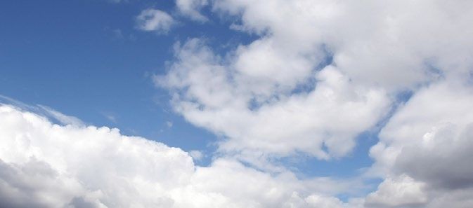
4. Altocumulus

 Altocumulus                                           Altocumulus

What to look for
This mid-level cloud is in the form of layers or
patches of individual clumps or rolls of cloud,
known as ‘cloudlets’. If you see a layer of cloud
that looks like it is made of lots of regular
cotton-wool balls, it might be an Altocumulus.
A similar looking cloud, though one that is rarer,
is the higher Cirrocumulus. This is also a layer or    Cirrocumulus
patch composed of little cloudlets but they
appear much smaller than the Altocumulus
ones. To distinguish between the two, you need        Key facts
to hold a finger up at arm’s length towards the       Altocumulus clouds
cloud directly above you. If the cloudlets are        sometimes produce rain
smaller than the width of your finger, the cloud      or snow but it rarely
is Cirrocumulus; if they are wider, it is probably    reaches the ground,
Altocumulus.                                          usually drying up as it
What they mean for us                                 falls. This creates trails
The rain and snow from Altocumulus may                below them which make
not tend to reach ground level but, to the            the cloudlets look
keen cloud spotter, these clouds can be early         like jellyfish.
indicators of storms ahead. If the cloudlets
have very bumpy tops they suggest that that
atmosphere at that level is unstable. This means
that any Cumulus clouds building up from                            70
below are likely to grow into Cumulonimbus
storm clouds that will bring heavy showers                Cloud points
in the afternoon.                                     (especially if they are arranged
                                                       in a beautiful organised layer,
                                                            like a quilted blanket)

The Great British Weather – Cloud Spotting Guide                                   5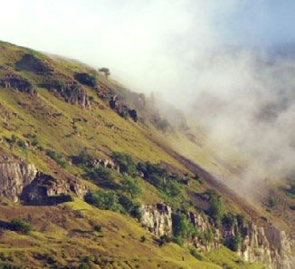
5. The Layer Clouds

 Altostratus                                            Stratus

What to look for
                                                      Key facts
Generally speaking, layer clouds are the most
                                                      Stratus clouds have
boring looking of all the cloud types. With no
                                                      bases at anywhere
variation in tone from one part to the next, they
                                                      from the ground to
are just a flat, overcast sky.
                                                      1,500ft. Altostratus are
Layer clouds form at all three cloud levels.          at 6,500-16,500ft.
The low ones are called Stratus, and can be           Cirrostratus have bases
right down at ground level, when they are             at 16,500-30,000ft,
known as fog or mist. They often block the Sun        while Nimbostratus can
completely. Mid-level layer clouds are called         be over 10,000ft deep.
Altostratus, and often make the Sun appear as
if through frosted glass. The high layer clouds
are called Cirrostratus, which are made of ice
crystals rather than droplets.
                                                                   45
What they mean for us
Altostratus can produce light to moderate
rain or snow, but the fourth layer cloud that              Cloud points
produces most precipitation is the Nimbostratus.
This thick blanket of cloud often extends
through all three levels and rains and rains.

 6                                 The Great British Weather – Cloud Spotting Guide
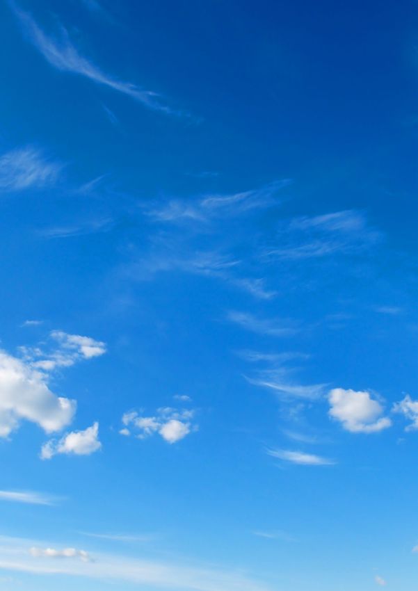
6. Cirrus

  Cirrus – Hampstead Heath                           Cirrus

What to look for
The most beautiful of the main cloud types,
Cirrus clouds are like watercolour brush strokes
across the blue. Composed of ice crystals
cascading through the high atmosphere they
are generally see-through. As the ice crystals
fall downwards through different regions of the
atmosphere, they pass through faster and             Cirrus – Bristol
slower winds and drier and moister air, which
give the cloud its distinctive wavy strokes,
known as ‘fallstreaks’.
                                                    Key facts
What they mean for us                               Cirrus clouds are
The falling ice crystals of Cirrus clouds never     named after the Latin
reach the ground, tending instead to evaporate      for a lock of hair.
on the way down. If they are seen to join
together and thicken into the high layer cloud
Cirrostratus, they can be an early indication of
a change in the weather that will lead to steady
rain. Other than that, they just look nice.                   60

                                                       Cloud points
“Being up in the clouds was awesome.
  I couldn’t taste anything – fear probably
  played a part in that – but thinking about
  it now, the smell was probably similar to
  when you open up the door of your deep
  freeze and you get that ‘cold/icy’ smell.”
 Carol Kirkwood

 The Great British Weather – Cloud Spotting Guide                       7
7. Contrails

 Contrails                                                Contrails

What to look for
                                                        Key facts
Short for ‘condensation trails’, these are the
                                                        Our atmosphere often
lines of cloud that can sometimes form behind
                                                        consists of differing
aircraft up at cruising height. Formed from the
                                                        layers of air so it is not
water vapour (water in gas form) that is part of
                                                        uncommon to see the
the aircraft exhaust, these straight, crisp lines of
                                                        contrails behind an
condensation could hardly look more different
                                                        aircraft appear to turn
from the wild, chaotic forms of the natural
                                                        on and off as it climbs
clouds. They only appear when the air up at
                                                        or descends.
cruising height is cold enough and moist
enough. At other times, no cloud appears
behind the plane.
What they mean for us
Contrails are the most visible signs of human                       60
effect on our atmosphere – sharp lines of
progress, dividing and dissecting the sky –                 Cloud points
man’s marks on what, for many of us, is the last            (because they are so
wilderness to gaze out at.                                  common these days)

 8                                   The Great British Weather – Cloud Spotting Guide
8. Lenticularis
Lenticularis Lenticularis
What to look for
Named after the Latin word for a lentil, these
are discs of cloud with smooth, streamlined
edges. They often look rather like UFOs.
Lenticularis clouds form in stable conditions
when moist winds have to rise to pass over
raised ground such as a hill or mountain peak.
While lenticularis clouds are most often seen Lenticularis
in hilly or mountainous regions, they can appear
downwind of even gentle, rolling hills when
the conditions are right. The water droplets Key facts
of lenticularis clouds form at one end of the Sometimes known as
cloud and rush through it with the wind, only ‘lennies’ for short,
to disappear again at the back of the cloud. these clouds can form
Though the droplets are moving, the cloud at any of the three
as a whole appears stationary in the steady cloud levels but the
wind at cloud level. most dramatic and
What they mean for us impressive ones are
Only very occasionally do lenticularis found in the mid-level
clouds produce any rain or snow that clouds, and are known
reaches the ground. as Altocumulus
lenticularis.
125
Cloud points
The Great British Weather – Cloud Spotting Guide 99. Mamma
Mammatus – Waterloo Bridge Mammatus
What to look for
Key facts
Also known as mammatus, these are pouches
Mamma are defined
that hang down from the underside of a cloud
as ‘supplementary
layer. They are easiest to spot when the Sun is
features’. The most
low, and is shining across the base of the cloud
dramatic-looking ones
layer, picking out the udder-like formations (the
form on the underside
name Mamma comes from the Latin for udders).
of the huge anvils that
They can be spotted hanging from the base of
spread out at the top
clouds at all three of the cloud levels. Mamma
of Cumulonimbus
clouds are fairly rare so you have to keep an eye
storm clouds.
out for them.
What they mean for us
Mamma clouds tend to appear attached to the
rear of the advancing storm and so they usually
indicate that the heavy showers are falling some 150
distance away, or that the storm has already
passed over. Cloud points
“You can carry on spotting when you’re abroad
– I saw mammatus in the USA. It’s shaped like
cows’ udders and had the setting sunlight
behind it. It looks heavy (it’s descending air)
almost like it is going to fall on top of you!”
Carol Kirkwood
10 The Great British Weather – Cloud Spotting Guide10. Noctilucent
Noctilucent Noctilucent
What to look for
Key facts
Noctilucent clouds form so high up in the
The shifting patterns
atmosphere – often around 50 miles up –
in the formation of
that they are way higher than the 10–12 miles
these mysterious
or so in which our normal weather clouds form.
clouds are increasingly
These strange clouds have an eerie, bluish-white considered valuable
appearance, and often exhibit delicate ripples indicators of our
or billows that can extend across huge areas of changing climate.
the sky. Their name means night shining. Being
so high, they still catch the sunlight when the
rest of the sky is dark.
These clouds are rare, and only form in the 300
summer – typically between the end of May and
mid-August. Look for them when the sky is clear
of lower clouds and within a few hours of sunset Cloud points
or sunrise.
What they mean for us
Noctilucent clouds are far, far too high to
have any direct effect on weather down on
the ground.
“Before you head out to take some pictures of
clouds, make sure your camera is fully charged.
I have come unstuck with this one in the past! If you
have one, stick a spare battery in your pocket too.”
Carol Kirkwood
The Great British Weather – Cloud Spotting Guide 11Get spotting!
Use our handy score card to Don’t forget Carol’s helpful tips
see how many of the clouds in about remembering to do some
our guide you can spot over the cloud spotting when you’re
coming weeks and see if you can on holiday.
reach our grand total of 1,000. Happy cloud spotting from the
Great British Weather team.
1. Cumulus 2. Stratocumulus
Altitude: Low: 1-5k ft Altitude: Low: 1-4.5k ft
Rainfall: Rainfall:
Rarity score: 60 Rarity score: 30
Date spotted: X Date spotted: X
Cloud score: Cloud score:
3. Cumulonimbus 4. Altocumulus
Altitude: Multi-level: 2-45k ft Altitude: Mid-level: 6.5-20k ft
Rainfall: Rainfall:
Rarity score: 100 Rarity score: 70
Date spotted: X Date spotted: X
Cloud score: Cloud score:
12 The Great British Weather – Cloud Spotting Guide5. The Layer Clouds 6. Cirrus
Altitude: All 3 layers Altitude: High: 20-40k ft
Rainfall: Rainfall:
Rarity score: 45 Rarity score: 60
Date spotted: X Date spotted: X
Cloud score: Cloud score:
7. Contrails 8. Lenticularis
Altitude: High: 20-40k ft Altitude: Low: 1-5k ft
Rainfall: Rainfall:
Rarity score: 60 Rarity score: 125
Date spotted: X Date spotted: X
Cloud score: Cloud score:
9. Mamma 10. Noctilucent
Altitude: All 3 layers Altitude: V.V. high: 30-50 miles
Rainfall: Rainfall:
Rarity score: 150 Rarity score: 300
Date spotted: X Date spotted: X
Cloud score: Cloud score:
Grand total
The Great British Weather – Cloud Spotting Guide 13Cloud
spotting
guide
bbc.co.uk/greatbritishweather
Writer
Gavin Pretor-Pinney, author of
The Cloud Collector’s Handbook and
founder of The Cloud Appreciation Society.
Photography
Page 3/12: Stratocumulus – Heather Reid
Page 10/12: Mamma – Shevaun Mendelsohn
Design
red-stone.com
Our thanks to BBC Weather and members of the
public for photographs contributed. Thanks also
to Carol Kirkwood and the Met Office.
© BBC Learning 2011You can also read