Dataset Generation Capability Description Document (DGCDD) H141 and H142 - ECMWF Confluence Wiki
←
→
Page content transcription
If your browser does not render page correctly, please read the page content below
Doc.No: SAF/HSAF/CDOP3/DGCDD/
                 Dataset Generation Capability
                                                 Issue/Revision: 0.3
                Description Document (DGCDD)     Date: 2020/03/12
                         H141 and H142           Page: 1/17

        EUMETSAT Satellite Application Facility on
  Support to Operational Hydrology and Water Management
                  http://hsaf.meteoam.it/

 Dataset Generation Capability
Description Document (DGCDD)
         H141 and H142
      Soil Wetness Index in the roots region
       Data Record and Offline extension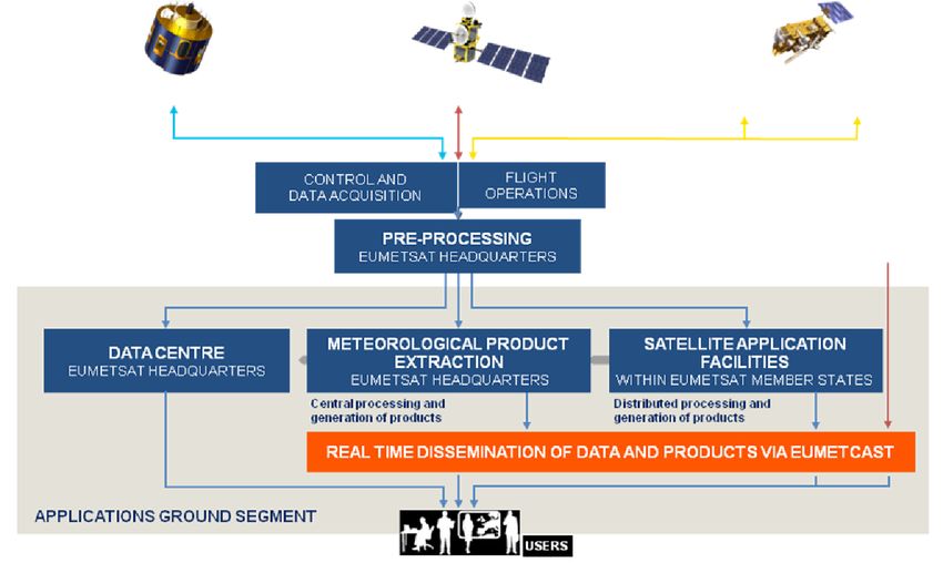
Doc.No: SAF/HSAF/CDOP3/DGCDD/
                               Dataset Generation Capability
                                                               Issue/Revision: 0.3
                              Description Document (DGCDD)     Date: 2020/03/12
                                       H141 and H142           Page: 2/17

Revision History

Revision   Date         Author(s)          Description
0.1        2019/05/07   David Fairbairn    First draft.
                        and Patricia de
                        Rosnay
0.2        2019/11/06   David Fairbairn    (i) Revised Table 4.1 to provide the correct pro-
                        and Patricia de    ducers and references of the H141 input scat-
                        Rosnay             terometer SSM products; (ii) The product name
                                           is now included in the title of the document.
0.3        2020/03/12   David Fairbairn    (i) Included descriptions of offline extension
                        and Patricia de    H142
                        Rosnay
Doc.No: SAF/HSAF/CDOP3/DGCDD/
                                     Dataset Generation Capability
                                                                                                    Issue/Revision: 0.3
                                    Description Document (DGCDD)                                    Date: 2020/03/12
                                             H141 and H142                                          Page: 3/17

Table of Contents
1. Executive summary                                                                                                                                                7

2. Introduction                                                                                                                                                      7
   2.1. Purpose of the document . . . . . . . . . . . . . . . . . . . . . . . . . . . . . . .                                                                        7
   2.2. Targeted audience . . . . . . . . . . . . . . . . . . . . . . . . . . . . . . . . . . .                                                                      7
   2.3. H SAF soil moisture products . . . . . . . . . . . . . . . . . . . . . . . . . . . . .                                                                       7

3. Introduction to the root-zone soil wetness data record H141                                                                                                       7
   3.1. Principal of the product . . . . . . . . . . . . . . . . . . . . . . . . . . . . . . . .                                                                     7

4. System design                                                                                                                                                     8
   4.1. Input data and pre-processing . . . . . . . .                           .   .   .   .   .   .   .   .   .   .   .   .   .   .   .   .   .   .   .   .   .    8
   4.2. HTESSEL land surface model . . . . . . . .                              .   .   .   .   .   .   .   .   .   .   .   .   .   .   .   .   .   .   .   .   .    8
   4.3. Extended Kalman filter . . . . . . . . . . .                            .   .   .   .   .   .   .   .   .   .   .   .   .   .   .   .   .   .   .   .   .   11
   4.4. Interfaces between the different components                             .   .   .   .   .   .   .   .   .   .   .   .   .   .   .   .   .   .   .   .   .   11

5. Processing environment                                                                                                                                           11
   5.1. Hardware configuration      .   .   .   .   .   .   .   .   .   .   .   .   .   .   .   .   .   .   .   .   .   .   .   .   .   .   .   .   .   .   .   .   11
   5.2. Software configuration .    .   .   .   .   .   .   .   .   .   .   .   .   .   .   .   .   .   .   .   .   .   .   .   .   .   .   .   .   .   .   .   .   12
   5.3. Processing performance      .   .   .   .   .   .   .   .   .   .   .   .   .   .   .   .   .   .   .   .   .   .   .   .   .   .   .   .   .   .   .   .   12
   5.4. Output data . . . . . . .   .   .   .   .   .   .   .   .   .   .   .   .   .   .   .   .   .   .   .   .   .   .   .   .   .   .   .   .   .   .   .   .   12

6. Conclusion                                                                                                                                                       12

7. References                                                                                                                                                       12

Appendices                                                                                                                                                          15

A. Introduction to H SAF                                                                                                                                            15

B. Purpose of the H SAF                                                                                                                                             15

C. Products / Deliveries of the H SAF                                                                                                                               16

D. System Overview                                                                                                                                                  17
Doc.No: SAF/HSAF/CDOP3/DGCDD/
Dataset Generation Capability
Issue/Revision: 0.3
Description Document (DGCDD) Date: 2020/03/12
H141 and H142 Page: 4/17
List of Tables
4.1. H141 (1992-2018) and H142 (2019-2021) input scatterometer SSM products. . . . 10
List of Figures
3.1. Illustration of the H141 root zone soil moisture production chain based on ERS-
1/2 and ASCAT-A/B satellite derived surface soil moisture data assimilation. . . 9
A.1. Conceptual scheme of the EUMETSAT Application Ground Segment. . . . . . . 15
A.2. Current composition of the EUMETSAT SAF Network. . . . . . . . . . . . . . . 16Doc.No: SAF/HSAF/CDOP3/DGCDD/
Dataset Generation Capability
Issue/Revision: 0.3
Description Document (DGCDD) Date: 2020/03/12
H141 and H142 Page: 5/17
List of Acronyms
ASAR Advanced Synthetic Aperture Radar (on Envisat)
ASAR GM ASAR Global Monitoring
ASCAT Advanced Scatterometer
ATBD Algorithm Theoretical Baseline Document
BUFR Binary Universal Form for the Representation of meteorological data
DORIS Doppler Orbitography and Radiopositioning Integrated by Satellite (on Envisat)
ECMWF European Centre for Medium-range Weather Forecasts
ERS European Remote-sensing Satellite (1 and 2)
ESA European Space Agency
EUMETCast EUMETSAT’s Broadcast System for Environment Data
EUMETSAT European Organisation for the Exploitation of Meteorological Satellites
FTP File Transfer Protocol
H SAF SAF on Support to Operational Hydrology and Water Management
HTESSEL Hydrology Tiled ECMWF Scheme of Surface Exchanges over Land
LDAS Land Data Assimilation System
Météo France National Meteorological Service of France
Metop Meteorological Operational Platform
NRT Near Real-Time
NWP Numerical Weather Prediction
PRD Product Requirements Document
PUM Product User Manual
PVR Product Validation Report
SAF Satellite Application Facility
SEKF Simplified Extended Kalman Filter
SSM Surface soil moisture
SWI Soil Wetness Index
TU Wien Technische Universität Wien (Vienna University of Technology)Doc.No: SAF/HSAF/CDOP3/DGCDD/
Dataset Generation Capability
Issue/Revision: 0.3
Description Document (DGCDD) Date: 2020/03/12
H141 and H142 Page: 6/17
WARP Soil Water Retrieval Package
WARP H WARP Hydrology
WARP NRT WARP Near Real-Time
ZAMG Zentralanstalt für Meteorologie und Geodynamic (National Meteorological Service of
Austria)Doc.No: SAF/HSAF/CDOP3/DGCDD/
Dataset Generation Capability
Issue/Revision: 0.3
Description Document (DGCDD) Date: 2020/03/12
H141 and H142 Page: 7/17
1. Executive summary
This document describes the setup of the H141 scatterometer root zone soil wetness index
product data record generation system for the period 1992-2018. The same requirements apply
to the offline extension of H141, called H142, for the period 2019-2021. An introduction (section
2) is followed by general overview of the H SAF root zone data record product (section 3).
The processing system and its design are discussed in section 4. The processing environment
outlines details about the hardware and software configuration of the system in section 5. Further
information on the implementation of the processing chain and individual processing steps are
available in the Algorithm Theoretical Basis Documents (ATBD [1]). The product user manual
gives instructions on how to access and plot the data [2]. The validation of H141 is performed
in the product validation report [3]. A conclusion if given in section 6.
2. Introduction
2.1. Purpose of the document
The Dataset Generation Capability Description Document (DGCDD) is intended to provide a
compact overview of the H141 data record processing system.
2.2. Targeted audience
This document mainly targets:
• Hydrology and water management experts
• Operational hydrology and Numerical Weather Prediction communities
• Users of remotely sensed soil moisture for a range of applications (e.g. climate modelling
validation, trend analysis)
2.3. H SAF soil moisture products
In the framework of the H SAF project several soil moisture products, with different timeliness
(e.g. near real time products and data records), spatial resolution, format (e.g. time series,
swath orbit geometry, global image) or the representation of the water content in various soil
layers (e.g. surface, root-zone), are generated on a regular basis and distributed to users. A list
of all available soil moisture products, as well as other H SAF products (such as precipitation
or snow) can be looked up on the H SAF website (hsaf.meteoam.it). More general information
about H SAF can be found in the Appendix. This document describes the production chain of
the H141 root zone soil wetness data record product.
3. Introduction to the root-zone soil wetness data record H141
3.1. Principal of the product
The H141 production chain uses an offline sequential Land Data Assimilation System (LDAS)
based on an Simplified Extended Kalman Filter (SEKF) method, as in [4]. The SEKF consti-
tutes the central component of the H141 production chain. The HTESSEL Land Surface ModelDoc.No: SAF/HSAF/CDOP3/DGCDD/
Dataset Generation Capability
Issue/Revision: 0.3
Description Document (DGCDD) Date: 2020/03/12
H141 and H142 Page: 8/17
is used to propagate in time and space the soil moisture information through the root zone, ac-
counting for physiographic information (soil texture, orography), meteorological conditions and
land surface processes such as soil evaporation and vegetation transpiration [5–7]. H141 is a root
zone soil moisture product derived from ERS/SCAT and Metop ASCAT-A/B surface soil mois-
ture (SSM) observations over from 1992 to 2018. Its offline extension H142 assimilates Metop
ASCAT-A/B/C from 2019 to 2021 and is updated at a yearly frequency. The retrieval approach
for both products relies on an offline, sequential Land Data Assimilation System (LDAS). The
ERS1/2 observations are assimilated from 1992 to 2006, the ASCAT-A observations for 2007-
2018, ASCAT-B for 2015-2018 and ASCAT-C from 2019-2021. Although the acquisition period
of the ERS2 scatterometer extended until September 2011, the ASCAT-A/B data is assimilated
instead of ER2 data after 2007 since each ASCAT sensor gives more than twice the coverage
(almost daily) of that provided by the ERS scatterometers [8]. The H141 production chain
also assimilates screen level parameters close to the surface (2-metre temperature and relative
humidity) to ensure consistency of the retrieved Scatterometer root zone and the near surface
observed weather conditions. The land surface model is driven by ERA5 atmospheric fields [9].
Figure 3.1 illustrates the H141 LDAS production suite. The H142 production suite is equivalent
to H141, except that ASCAT-C is assimilated from 2019 onwards.
4. System design
4.1. Input data and pre-processing
Table 4.1 below gives the details on the scatterometers SSM products used as input for the H141
and H142 production suites. As shown in Table 4.1 there is no overlap between ERS1/2 and
ASCAT-A/B/C observations used to produce H141 and H142. In the ECMWF H141 algorithm
(and its extension H142) the input scatterometer SSM products are assimilated in an offline
LDAS which propagates the scatterometer SSM information in space on the soil vertical profile
and in time at a daily time scale. The main components of the data assimilation system are
the SEKF, a land surface model and input data re-processing. A detailed description of the
ECMWF H141 LDAS algorithm can be found in the ATBD [1].
A rescaling approach, based on a simplified Cumulative Distribution Function matching (CDF-
matching), as described in [10], is used as part of the data assimilation system as a form of bias
correction (see [1] for details). The H141 production chain also assimilates screen level variables
(2-meter temperature and relative humidity). These were obtained in ERA5 using an optimal
interpolation method leading to a global coverage of the two variables. Similarly T2m and
RH2m fields are also used in the production of H14.
4.2. HTESSEL land surface model
In the H141 production chain, the time and vertical propagation of soil moisture from the surface
soil toward the root zone is driven by the HTESSEL land surface model [5–7]. The HTESSEL
formulation of the soil hydrological conductivity and diffusivity accounts for spatial variabilities
following global soil texture map [11]. A monthly leaf area index (LAI) climatology is used as
described in [12]. Surface runoff is based on the variable infiltration capacity. The soil heat
budget follows a Fourier diffusion law, modified to take into account soil water freezing/melting
according to [13]. Bare ground evaporation over dry land uses a lower stress threshold than for
the vegetation, allowing a higher evaporation [14].Doc.No: SAF/HSAF/CDOP3/DGCDD/
Dataset Generation Capability
Issue/Revision: 0.3
Description Document (DGCDD) Date: 2020/03/12
H141 and H142 Page: 9/17
Figure 3.1: Illustration of the H141 root zone soil moisture production chain based on ERS-1/2
and ASCAT-A/B satellite derived surface soil moisture data assimilation.Doc.No: SAF/HSAF/CDOP3/DGCDD/
Dataset Generation Capability
Issue/Revision: 0.3
Description Document (DGCDD) Date: 2020/03/12
H141 and H142 Page: 10/17
Table 4.1: H141 (1992-2018) and H142 (2019-2021) input scatterometer SSM products.
Scaterrometer SSM product used in H141 data record
Period Sensor Producer Reference
ASCAT-A
(03/2014 to
12/2021),
ASCSMO02: ASCAT-A/B/C 25 km
ASCAT-B
swath grid product distributed by CAF.
(01/2015 to
(https://vnavigator.eumetsat.int/product/EO:
04-2014 to 12/2021) EUMETSAT
EUM:DAT:METOP:SOMO25). Equivalent to H
12-2021 and CAF
SAF level 2 surface soil moisture products H102
ASCAT-C
(Metop-A 25 km sampling), H103 (Metop-B 25 km
(10/2019 to
sampling) and H105 (Metop-C 25 km sampling).
12/2021)
25 km
sampling
ASCAT-
01-2007 to H107: H SAF soil moisture data record reprocessed
A 25 km TU Wien
03-2014 level 2 surface soil moisture.
sampling
ERS-1/2 AMI WARP 5.5 R1.1: ERS-1/2
AMI 50km Soil moisture time series prod-
ERS 1/2 uct. Produced as part of the Scirroco
01-1992 to
AMI 50 km TU Wien project (https://earth.esa.int/documents/)
12-2006
sampling 700255/2925769/SCI-PRE-2015-0001-v-01-SM_
reprocessing_TUW.pdf) using the Water Retrieval
Package (WARP) version 5.5.Doc.No: SAF/HSAF/CDOP3/DGCDD/
Dataset Generation Capability
Issue/Revision: 0.3
Description Document (DGCDD) Date: 2020/03/12
H141 and H142 Page: 11/17
4.3. Extended Kalman filter
A point-wise Simplified Extended Kalman Filter (SEKF) is used to assimilate scatterometer
surface soil moisture to produce the H141 root zone soil moisture. The SEKF constitutes the
core of the H141 production chain and it is described in detail in the ATBD [1].
The soil moisture component of the observation-error matrix R varies both in time and space,
as the ERS1/2 and ASCAT-A/B noise level information is used as observation error. Observation
error covariances for RH2M and T2M are set to 4% and 2 Kelvin, respectively. The background
error covariance matrix B is a diagonal matrix which values vary in space depending on the soil
texture following the approach of [15, 16]. The background error standard deviation is set to
5% of the water holding capacity (difference of soil moisture between field capacity and wilting
point). For each grid point it is constant in time and for the vertical soil profile.
The H141 production chain relies on 24h data assimilation window, covering 00 UTC to
24 UTC daily. Analyzed screen level variables (two-meter temperature and relative humidity)
available at 06:00, 12:00 and 18:00UTC, and scatterometers SSM observations available at 00:00
(+/-3h), 06:00(+/-3h), 12:00 (+/-3h) and 18:00 (+/-3h) UTC are assimilated. The increments
are applied at the beginning of the 24-hour data assimilation window, as in the equivalent
simplified 2D-Var described in [17]. So, for each 24-hour analysis cycle, the H141 production
suite runs five trajectories of HTESSEL:
• The first trajectory provides the model background;
• The second, third and fourth trajectories are produced by perturbing the soil moisture
initial conditions of the first, second and third layer, respectively;
• The fifth trajectory is produced with the analysis increments applied at the beginning of
the 24-hour window. It is the analysed trajectory. Its 24 h window length provides the
initial conditions of the next data assimilation window.
4.4. Interfaces between the different components
The core of the H141 producton chain, the SEKF algorithm, is coded in Python. The land
surface model is coded in Fortran 90 and the input/output data as well as the files exchanged
between the SEKF and the land surface model are in the GRIB format. The overall system is
organised using a combination of Python and korn shell scripts that control the system interface
and successive tasks organisation and triggers under the ECMWF ECFLOW system 1 .
5. Processing environment
5.1. Hardware configuration
The H141 LDAS production chain was run on the ECMWF’s multi-petaflops supercomputer
Cray XC40 (Unix).
1
https://confluence.ecmwf.int/display/ECFLOW/ecflow+homeDoc.No: SAF/HSAF/CDOP3/DGCDD/
Dataset Generation Capability
Issue/Revision: 0.3
Description Document (DGCDD) Date: 2020/03/12
H141 and H142 Page: 12/17
5.2. Software configuration
The H141 LDAS production chain is maintained in the software version control system GIT 2 .
In this version system the specific branch used to produce H141 is
dadf_CY46R1.20181221_offline_LDAS.
5.3. Processing performance
The production of 27 years of H141 takes around four months. The production of the offline
extension (H142) is done at a yearly frequency between 2019 and 2021 and is therefore much
less time-consuming (approximately 4 days per year). The most time consuming processing
step is the SEKF algorithm, which relies on Cholesky decomposition. The second most time
consuming processing step is the Input/Output part of the H141 suite which consists in reading
observations and model input (forcing, physiography information) from the archive and writing
and archiving the H141 suite output.
5.4. Output data
H141 is provided in two different file formats at approximately 10 km resolution: 1) An octa-
hedral reduced Gaussian grid (TCO 1279) in GRIB format, which has approximately equidistant
grid points between the equator and the poles, and 2) a 0.1 degree regular lat/lon grid in netCDF
format. The latter is significantly more expensive to store. However, most standard software
packages are better suited to reading in netCDF with regular lat/lon grids than GRIB files.
The GRIB data can be read in and plotted using the metview-python software developed by
ECMWF ( [2] gives details).
6. Conclusion
The H141 data record product consists of a unique historically consistent scatterometer derived
root zone soil wetness index database over the period 1992-2018. Its offline extension H142
produced over the period 2019-2021 and is updated at a yearly frequency. The product results
from data assimilation which enables the propagation of the surface soil moisture information
observed by scatterometers (ERS 1/2 and ASCAT-A/B/C) to the root zone, taking into account
the consistency with ERA5 atmospheric fields used to force the offline LDAS.
The SEKF code itself is written in Python, although the land surface model is coded in
Fortran 90. The whole sytem is developed using the ECFLOW interface structure provided by
ECMWF and using the GIT version control system. In total, it takes approximately 4 months
to run the H141 production. The most expensive process is the SEKF itself due to large matrix
calculations.
7. References
[1] ATBD, “H141: Algorithm Theoretical Baseline Document, Soil Wetness Index in the roots
region, Data Record,” in H141 ATBD. H SAF, 2019, [Available online at http://hsaf.
meteoam.it/user-documents.php.].
2
https://git-scm.comDoc.No: SAF/HSAF/CDOP3/DGCDD/
Dataset Generation Capability
Issue/Revision: 0.3
Description Document (DGCDD) Date: 2020/03/12
H141 and H142 Page: 13/17
[2] PUM, “H141: Product User Manual, Soil Wetness Index in the roots region, Data Record,”
in H141 PUM. H SAF, 2019, [Available online at http://hsaf.meteoam.it/user-documents.
php.].
[3] PVR, “H141: Product Validation Report, Soil Wetness Index in the roots region, Data
Record,” in H141 PVR. H SAF, 2019, [Available online at http://hsaf.meteoam.it/
user-documents.php.].
[4] P. de Rosnay, M. Drusch, D. Vasiljevic, G. Balsamo, C. Albergel, and L. Isaksen, “A simpli-
fied Extended Kalman Filter for the global operational soil moisture analysis at ECMWF,”
Quart. J. Roy. Meteor. Soc., vol. 139, pp. 1199–1213, 2013.
[5] B. van den Hurk, P. Viterbo, A. Beljaars, and A. Betts, “Offline validation of the ERA-
40 surface scheme,” in Technical Memorandum 295. ECMWF, 2000, [Available online at
http://www.ecmwf.int/publications/.].
[6] B. van den Hurk and P. Viterbo, “The Torne-Kalix PILPS 2(e) experiment as a test bed for
modifications to the ECMWF land surface scheme,” Global and Planetary Change, vol. 38,
pp. 165–173, 2003.
[7] G. Balsamo, A. Beljaars, K. Scipal, P. Viterbo, B. van den Hurk, M. Hirschi, and A. Betts,
“A Revised Hydrology for the ECMWF Model: Verification from Field Site to Terrestrial
Water Storage and Impact in the Integrated Forecast System,” J. Hydrometeor., vol. 10,
pp. 623–643, 2009.
[8] Z. Bartalis, W. Wagner, V. Naeimi, S. Hasenauer, K. Scipal, H. Bonekamp, J. Figa, and
C. Anderson, “Initial soil moisture retrievals from the METOP-A Advanced Scatterometer
(ASCAT),” Geophys. Res. Lett., vol. 34, 2007.
[9] H. Hersbach and D. Dee, “ERA–5 reanalysis is in production,” in newsletter No.
147. ECMWF, 2016, [Available online at https://www.ecmwf.int/en/newsletter/147/
news/era5-reanalysis-production.].
[10] D. M. Scipal, K. and W. Wagner, “Assimilation of a ERS scatterometer derived soil moisture
index in the ECMWF numerical weather prediction system,” Adv. Water Resour., vol. 31,
2008.
[11] FAO, ““Digital soil map of the world (DSMW)”,” in Technical report. Food and Agriculture
organization of the United Nations, 2003.
[12] S. Boussetta, G. Balsamo, A. Beljaars, T. Kral, and L. Jarlan, “Impact of a satellite–derived
leaf area index monthly climatology in a global numerical weather prediction model,” Int.
J. Remote Sens., vol. 34(9-10), pp. 3520–3542, 2013.
[13] P. Viterbo and A. Beljaars, “An improved land surface parameterization scheme in the
ECMWF model and its validation,” J. Climate, vol. 8, 1995.
[14] C. Albergel, P. De Rosnay, C. Gruhier, J. Muñoz Sabater, S. Hasenauer, I. L., Y. Kerr,
and W. Wagner, “Evaluation of remotely sensed and modelled soil moisture products using
global ground–based in situ observations,” Remote Sens. Environ., vol. 118, pp. 215–226,
2012.Doc.No: SAF/HSAF/CDOP3/DGCDD/
Dataset Generation Capability
Issue/Revision: 0.3
Description Document (DGCDD) Date: 2020/03/12
H141 and H142 Page: 14/17
[15] C. S. Draper, J.-F. Mahfouf, and J. Walker, “An EKF assimilation of AMSR-E soil moisture
into the ISBA land surface scheme,” J. Geophys. Res., vol. 114, p. D20104, 2009.
[16] J.-F. Mahfouf, “Assimilation of satellite-derived soil moisture from ASCAT in a limited-area
NWP model,” Quart. J. Roy. Meteor. Soc., vol. 136, pp. 784–798, 2010.
[17] G. Balsamo, F. Bouyssel, and J. Noilhan, “A simplified bi-dimensional variational analysis
of soil moisture from screen-level observations in a mesoscale numerical weather-prediction
model,” Quart. J. Roy. Meteor. Soc., vol. 598, pp. 895–915, 2004.Doc.No: SAF/HSAF/CDOP3/DGCDD/
Dataset Generation Capability
Issue/Revision: 0.3
Description Document (DGCDD) Date: 2020/03/12
H141 and H142 Page: 15/17
Appendices
A. Introduction to H SAF
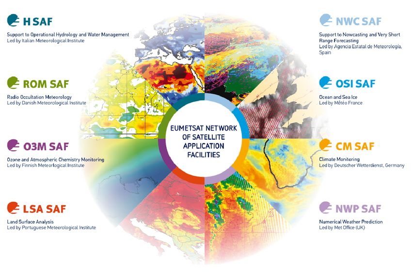
H SAF is part of the distributed application ground segment of the “European Organization for
the Exploitation of Meteorological Satellites (EUMETSAT)”. The application ground segment
consists of a Central Application Facilities located at EUMETSAT Headquarters, and a network
of eight “Satellite Application Facilities (SAFs)”, located and managed by EUMETSAT Member
States and dedicated to development and operational activities to provide satellite-derived data
to support specific user communities (see Figure A.1):
Figure A.1: Conceptual scheme of the EUMETSAT Application Ground Segment.
Figure A.2 here following depicts the composition of the EUMETSAT SAF network, with the
indication of each SAF’s specific theme and Leading Entity.
B. Purpose of the H SAF
The main objectives of H SAF are:
a) to provide new satellite-derived products from existing and future satellites with sufficient
time and space resolution to satisfy the needs of operational hydrology, by generating, cen-
tralizing, archiving and disseminating the identified products:
• precipitation (liquid, solid, rate, accumulated);
• soil moisture (at large-scale, at local-scale, at surface, in the roots region);Doc.No: SAF/HSAF/CDOP3/DGCDD/
Dataset Generation Capability
Issue/Revision: 0.3
Description Document (DGCDD) Date: 2020/03/12
H141 and H142 Page: 16/17
Figure A.2: Current composition of the EUMETSAT SAF Network.
• snow parameters (detection, cover, melting conditions, water equivalent);
b) to perform independent validation of the usefulness of the products for fighting against floods,
landslides, avalanches, and evaluating water resources; the activity includes:
• downscaling/upscaling modelling from observed/predicted fields to basin level;
• fusion of satellite-derived measurements with data from radar and raingauge networks;
• assimilation of satellite-derived products in hydrological models;
• assessment of the impact of the new satellite-derived products on hydrological applica-
tions.
C. Products / Deliveries of the H SAF
For the full list of the Operational products delivered by H SAF, and for details on their charac-
teristics, please see H SAF website hsaf.meteoam.it. All products are available via EUMETSAT
data delivery service (EUMETCast1 ), or via ftp download; they are also published in the H SAF
website2 .
All intellectual property rights of the H SAF products belong to EUMETSAT. The use of
these products is granted to every interested user, free of charge. If you wish to use these
products, EUMETSAT’s copyright credit must be shown by displaying the words “copyright
(year) EUMETSAT” on each of the products used.
1
http://www.eumetsat.int/website/home/Data/DataDelivery/EUMETCast/index.html
2
http://hsaf.meteoam.itDoc.No: SAF/HSAF/CDOP3/DGCDD/
Dataset Generation Capability
Issue/Revision: 0.3
Description Document (DGCDD) Date: 2020/03/12
H141 and H142 Page: 17/17
D. System Overview
H SAF is lead by the Italian Air Force Meteorological Service (ITAF MET) and carried on by
a consortium of 21 members from 11 countries (see website: hsaf.meteoam.it for details)
Following major areas can be distinguished within the H SAF system context:
• Product generation area
• Central Services area (for data archiving, dissemination, catalogue and any other central-
ized services)
• Validation services area which includes Quality Monitoring/Assessment and Hydrological
Impact Validation.
Products generation area is composed of 5 processing centres physically deployed in 5 different
countries; these are:
• for precipitation products: ITAF CNMCA (Italy)
• for soil moisture products: ZAMG (Austria), ECMWF (UK)
• for snow products: TSMS (Turkey), FMI (Finland)
Central area provides systems for archiving and dissemination; located at ITAF CNMCA
(Italy), it is interfaced with the production area through a front-end, in charge of product
collecting. A central archive is aimed to the maintenance of the H SAF products; it is also
located at ITAF CNMCA.
Validation services provided by H SAF consists of:
• Hydrovalidation of the products using models (hydrological impact assessment);
• Product validation (Quality Assessment and Monitoring).
Both services are based on country-specific activities such as impact studies (for hydrological
study) or product validation and value assessment. Hydrovalidation service is coordinated by
IMWM (Poland), whilst Quality Assessment and Monitoring service is coordinated by DPC
(Italy): The Services activities are performed by experts from the national meteorological and
hydrological Institutes of Austria, Belgium, Bulgaria, Finland, France, Germany, Hungary, Italy,
Poland, Slovakia, Turkey, and from ECMWF.You can also read