Drones for Environmental Mapping - Instructors - UVM Continuing Education
←
→
Page content transcription
If your browser does not render page correctly, please read the page content below
Drones for Environmental Mapping
Instructors
Jarlath O'Neil-Dunne
(lead instructor)
joneildu@uvm.edu
802.656.3324
Aiken Center, Room 205
www.uvm.edu/~joneildu

Adam Zylka
(UAS expert)
azylka@uvm.edu
Aiken Center, Room 205
802.656.3007

About this Course
Description
Drones are providing us with new ways to map, monitor, and measure our changing landscape. Advances in digital
image processing enable one to go from flying a drone to working with accurate maps and 3D models in a matter of
hours. In this course, you will learn how to use drones and other geospatial technologies to help us better understand
our changing environment. Upon completion of this course, you will have applied skills and theoretical knowledge
that will aid you in your college studies and in your professional career.

                                                                                                                     1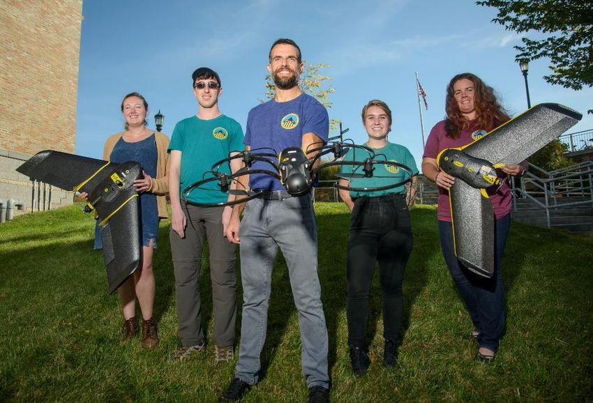
The course covers three main topics: data collection, data processing and analysis, and critical thinking. The goals for
this course are to provide students with an in-depth understanding of drone technology and how it can be applied for
environmental assessment. The course
is technical in nature, but it is designed
to be accessible to anyone who has an
interest in drones and the
environment. Technologies students
will be exposed to include: drone
platforms, drone sensors, flight
planning software, image processing
software, desktop Geographic
Information Systems (GIS), and web
mapping. Students will work closely
with members of the University of
Vermont UAS Team, one of the most
experienced drone groups in the United States.

Learning Objectives
•   State drone regulations
•   Develop safety procedures
•   Implement flight checklists
•   Identify the capabilities and limitations of drones for various types of environmental applications
•   Categorize the different types of drones
•   Recognize the various drone sensors
•   Plan a drone mission
•   Process drone data
•   Apply the principals of the
    electromagnetic spectrum to
    interpret remotely sensed data
•   Integrate drone with other types
    of geospatial products
•   Perform geospatial analysis
•   Employ the raster and vector data
    models for analysis and
    visualization
•   Create a web app to share data
    and analytical products
•   Develop safety procedures for UAS flight operations.
•   Implement a UAS pre-flight checklist.
•   Understand the capabilities and limitations of UAS in the context of environmental mapping.
•   Categorize the different types of UAS.
•   Recognize the various sensors that can be mounted on a UAS.
•   Plan a UAS mission.

                                                                                                                       2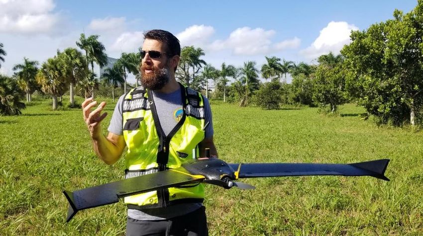
•   Operate fixed-wing and multi-rotor UAS.
•   Complete Manual and Automated
    Flights.
•   Process UAS imagery to generate
    geospatial data products.
•   Evaluate the quality of UAS data
    products.
•   Integrate UAS data with other
    types of geospatial products.
•   Analyze UAS data products.
•   Create web apps and other
    decision-support products from
    UAS data.
•   Compare UAS products to other
    types of geospatial data products
    in the context of environmental assessment.

Prerequisites
There are no formal prerequisites for this course. Students should have a strong interest in the environment and
natural resources. No knowledge of drone technology is required. A high level of comfort using a computer is
recommended.

Format
This course is being offered entirely online for the summer 2021 session due to the COVID-19 situation. Through
lectures, multimedia content, research, and hands-on activities, students will virtually use drone data to perform
various environmental assessments. The intent is to have students be able to plan a drone mission, process, drone
data, analyze the data, and think critically about the problem they are tasks with solving.

The course is divided into six learning modules. Each learning module is a specific environmental mapping problem
that drone technology can help play a role in solving. Modules
will consist of three main activities: 1) preparation, 2) data
processing, and 3) analysis. Each module will begin with a live,
online lecture that will introduce students to the module
topics. Students will be provided with background materials,
consisting of readings and videos to orient themselves to the
problem. Students will then obtain and process the drone data
to prepare it for analysis. In the analysis phase, they will
interpret and analyze the data to draw conclusions, integrating
the background research they have been done on the topic.
Each module submission will require students to answer
questions and submit materials. Questions will focus on both the environmental problem and the technical aspects of
drone technology. Questions will consist of true/false, multiple-choice, short answer, and essay. Materials
submissions will include items such as flight checklists, data uploads, screen captures, and links web applications.

                                                                                                                     3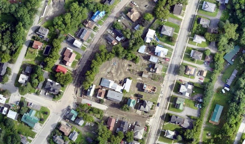
Participation activities include attending lectures and engaging in online discussion forums.

Grades
Grading is based on the submission for each module and participation. A complete breakdown of the grading is
presented in the table below. The participation grade is determined from lecture attendance and engagement in the
discussion forum.

 Activity          Points
 Participation     10
 Module 0          6
 Module 1          12
 Module 2          12
 Module 3          12
 Module 4          12
 Module 5          12
 Module 6          12
 Module 7          12
 Total             100

Course Materials
E-Learning Platform
This course will use UVM's e-learning platform, Blackboard.

Textbook
There is no textbook requirement for this course.

Computer Requirements
Students will need access to a computer with a
broadband internet connection for the duration of
this course. A computer running the Windows,
Macintosh, or Chrome operating system will
suffice. Students will be provided with an account
that gives them access to UVM's Virtual Desktop
Infrastructure (VDI), which provides them all of
the software they need in a virtual environment.

Software Requirements
The course fees cover a semester license for Pix4D, which students can run through their browser or via the VDI.
Students will also receive accounts for ArcGIS and access to Microsoft Office via the VDI.

                                                                                                                    4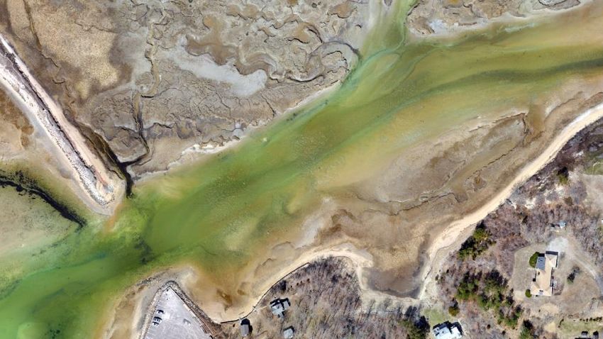
Schedule
This course will run from July 6th to July 30th for the 2021 session. Students should plan on attending nine virtual
lecture sessions, a course overview session, one for each module, and an end of the course session. Additionally,
virtual help sessions will be held for each module, providing students the opportunity to ask questions. Modules will
require ten to twenty hours of work, which will be spread out over multiple days. The timing of virtual lectures will be
established at the start of the course so as to accommodate as many students as possible. All lectures will be
recorded.

Modules
1: Construction Mapping - Brandon
Learning objectives
•   Identify the risks of operating a UAS
•   List the checks one would employ to
    ensure UAS are operating legally
•   State examples of UAS operations that
    require regulatory waivers
•   Recognize controlled airspace
•   Develop a flight checklist
•   Process UAS imagery
•   Compile UAS imagery using desktop GIS
•   Interpret UAS imagery
•   Compare UAS imagery to base imagery

Topics
•   Flight checklists
•   Platforms/Sensors
•   Learning Objectives
•   Why choose UAS over other systems?
•   Why choose a specific sensor for certain
    projects?
•   Presentations
•   Remote Sensing 101
•   Satellite
•   Aerial aircraft
•   On the ground field work
•   Platforms
•   Fixed Wing
•   Multi-rotor
•   Sensors

                                                                                                                       5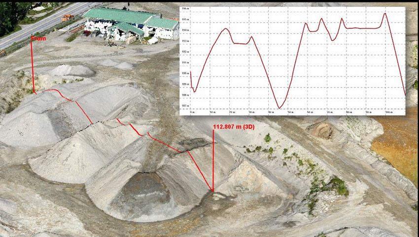
• RGB
• MSP
• Thermal
• LiDAR
• Flight Planning
• Data Processing
• Intro to GIS?
• Open data in ArcGIS Pro
• View data products in Arc
• Create hillshade for DSM/DTM
Activities
Prep
• Flight checklist
• Airspace evaluation
• Flight plan
• Platform/sensor selection
• Flight checklist - peer review
Processing
• Process data in Pix4D
Analysis
• Load data into ArcGIS Pro
• Compare UAS imagery to base imagery
• Generate cartographic products
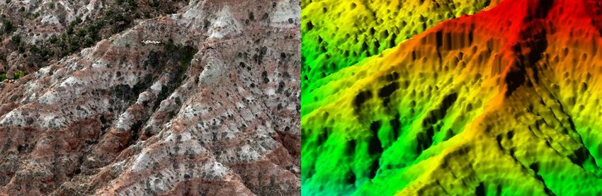
2: 3D Model - NH Rock Slope
Learning Objectives
• Identify the risks in operating UAS in proximity to people
• Explain the process of generating 3D models from UAS data
• State the rationale for monitoring rock slopes
• Present 3D data
Topics
• Risk assessment
6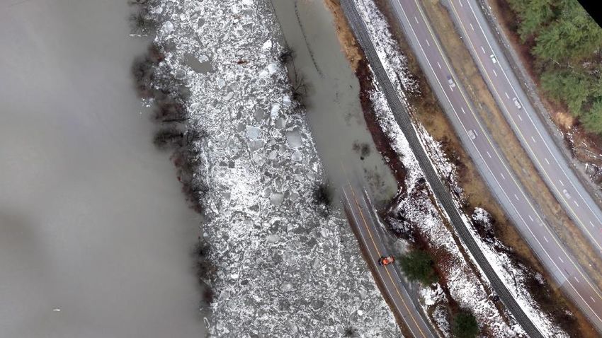
•   3D modeling
•   3D analysis

Activity
•   Prep
•   Flight checklist
•   Airspace evaluation
•   Risk assessment
•   Flight plan
•   Platform/sensor selection
•   Processing
•   Download data
•   Pix4D processing
•   Analysis
•   View the 3D data (Pix4D)
•   Assess the capabilities and limitations of the 3D model
•   Research other methods of obtaining 3D models of rock slopes
•   List some advantages and disadvantages of the UAS-based approach

3: Coastal Change - Cape Cod
Learning Objectives
•   Explain the risks of sea level rise
•   Discuss the challenges of coastal change mapping
•   Classify shoreline using desktop GIS
•   Compare UAS and standard aerial
    imagery
•   Interpret UAS and standard aerial
    imagery
•   Measure distance using desktop GIS
•   Create features using desktop GIS

Topics
•   Creating a feature class
•   Creating a feature
•   Attributes
•   Data types
•   Measurements
•   Image display

                                                                       7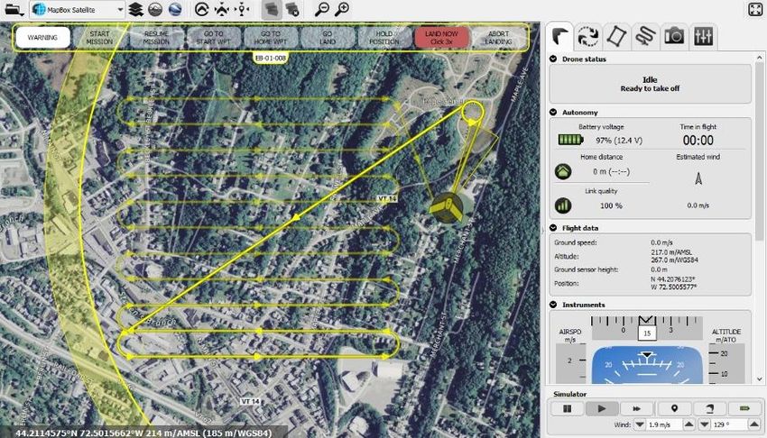
•   Web services

Activities
Prep
•   Platform/sensor selection
•   Site background research

Processing
•   Pix4D processing
•   Obtain existing imagery (MassGIS)

Analysis
•   Display imagery (ArcGIS)
•   Digitize shoreline
•   Compare imagery
•   Analyze the shoreline change

4: Sustainable Energy - McNeil Plant
Learning objectives
•   List the reasons communities are moving towards Net Zero
•   State some possible unitended consequences of Net Zero
•   Employ UAS to capture data suitable for 3D measruements
•   Compute volume from photogrammetricly derived 3D models
•   Summarize the results of a geospatial analysis workflow

Topics
•   Raster surface models
•   Raster calculations
•   Raster functions
•   Raster symbology
•   Volumetric calculations

Activities
Prep
•   Research Burlington's Net Zero goals
•   Research the McNeil Plant
•   Research biomass electric generation

Processing
•   Download data

                                                               8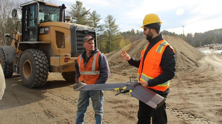
•   Pix 4D processing

Analysis
•   What is Burlington's Net Zero goal
•   How does the Mc Neil Plant factor into the Net Zero
    goal?
•   What is the purpose of the 3D biomass analysis
•   Review data
•   Compute nDSM
•   Calculate volume
•   Write report

5: Aquatic Invasive Species - Bullis Pond
Learning objectives
•   Develop a geodatabase for storing spatial data
•   Interpret multispectral imagery
•   Extract information from multispectral imagery
•   Apply remote sensing color theory to generate multispectral image composites
•   List why water chestnuts are a species of concern within the Lake Champlain Basin

Topics
•   Electromagnetic radiation
•   Remote sensing color theory
•   Geodatabase design
•   Feature editing
•   Image display

Activities
Prep
•   Research water chestnut
•   Download data

Processing
•   Pix4D processing of multispectral data
•   Pix4D processing of true color data

Analysis
•   True color image display
•   Multispectral image display
•   Create a geodatabase
•   Digitize features
•   Assess the capabilities and limitations of UAS for water chestnut mapping

                                                                                        9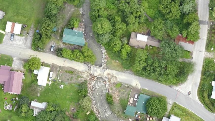
6: Stream Woody Debris Movement - Great Brook
Learning objectives
•   Recognize the effect storms have on
    woody debris movement
•   State the ecological benefits of woody
    debris
•   Explain the risks that woody debris pose to
    transportation infrastructure
•   Summarize the issues affecting the Great
    Brook
•   Discuss the need for temporal resolution in
    remote sensing monitoring of streams and
    rivers
•   Assess the capabilities and limitations of
    various remote sensing platforms for stream monitoring and mapping
•   Interpret multi-temporal imagery
•   Developing a spatio-temporal geodatabase

Topics
•   Temporal resolution
•   Woody debris in streams
•   Stream channel dynamics
•   Disaster response
•   Geodatabase design
•   Feature mapping
•   Feature attributes
•   Web maps and web apps

Activities
Prep
•   Background reading on woody debris
•   Background reading on the extreme
    weather event

Processing
•   Process pre-event data
•   Process post-event data

Analysis
•   Map pre-woody debris
•   Map post-woody debris'

                                                                         10
• Quantify change
• Spatial assessment of the movement of woody debris
• Conclusions on woody debris movement
• Web app
7: Conservation Easements: Mad River Valley
Learning objectives
• Explain how riparian buffers reduce
nonpoint source pollution
• Characterize riparian buffers using remotely
sensed data
• Communicate findings using story maps
• Evaluate the coverage of vegetative buffers
along the Mad River
• Compute area metrics using GIS
• Construct a plan for conservation easement
mapping
• Interpret photogrammetrically derived
surface models
Topics
• Agricultural runoff
• Conservation easements
• Feature editing
• Point cloud classification
• Area calculations
• Surface model interpretation
• Hydrologic modeling
• Story maps
Activities
Prep
• Research water quality issues for the Mad River
• Research riparian buffers
11• Download data
Processing
• Image processing
• Point cloud classification
Analysis
• Riparian buffer functions
• Issues affecting water quality in the Mad
River Valley
• Area of riparian buffers
• Flow pattern analysis
• Create a story map
Policies
Assignment submissions
The assignments in the course build upon each other and thus, it is crucial to submit them on time. Late submissions
inhibit the ability to carry out virtual review sessions and create a cascading effect in which a student becomes
perpetually behind. Only in exceptional circumstances will extensions be granted.
Questions
To ensure a fair and open process, questions about the course, assignments, and software issues should be posted to
the appropriate discussion forum on Blackboard. The lead instructor should only be emailed for questions that are
personal in nature. Examples include questions about a grade or a request for an assignment extension.
Our Common Ground
The University of Vermont is an educationally purposeful community seeking to prepare students to live in a diverse
and changing world. We who work, live, study, teach, do research, conduct business, or participate in the University
of Vermont are members of this community. As members, we believe in the transforming power of education and
agree to help create and foster an environment where we can discover and reach our true potential.
We aspire to be a community that values:
RESPECT. We respect each other. We listen to each other, encourage each other and care about each other. We are
strengthened by our diverse perspectives.
INTEGRITY. We value fairness, straightforward conduct, adherence to the facts, and sincerity. We acknowledge when
things have not turned out the way we had hoped. As stewards of the University of Vermont, we are honest and
ethical in all responsibilities entrusted to us.
INNOVATION. We want to be at the forefront of change and believe that the best way to lead is to learn from our
successes and mistakes and continue to grow. We are forward-looking and break new ground in addressing important
community and societal needs.
12OPENNESS. We encourage the open exchange of information and ideas from all quarters of the community. We
believe that through collaboration and participation, each of us has an important role in determining the direction
and well-being of our community.
JUSTICE. As a just community, we unite against all forms of injustice, including, but not limited to, racism. We reject
bigotry, oppression, degradation, and harassment, and we challenge injustice toward any member of our community.
RESPONSIBILITY. We are personally and collectively responsible for our words and deeds. We stand together to
uphold our common ground.
Instructor roles & Responsibilties
Your instructor will oversee all aspects of the course. You should expect your instructor and teaching assistants to be
knowledgeable, professional, approachable, and take an interest in your performance in this course.
Student Roles & Responsibilities
Students should be guided by UVM's "Our Common Ground" principals throughout this course. This is a college-level
course, and students, although they may still be in high school, will be treated the same as any other UVM student.
Students are expected to come prepared and show up promptly for all sessions. UVM's academic integrity policy
(https://www.uvm.edu/policies/student/acadintegrity.pdf) will be strongly enforced. Students are encouraged to
take advantage of the multitude of resources UVM offers to ensure student success ranging from the ACCESS office to
the Center for Health and Wellbeing. Students requiring any accommodations for this course should notify the
instructors at the start of class.
13You can also read