The Cloud-Aerosol Transport System (CATS): A Technology Demonstration on the International Space Station
←
→
Page content transcription
If your browser does not render page correctly, please read the page content below
Invited Paper

                            The Cloud-Aerosol Transport System (CATS):
                     A Technology Demonstration on the International Space Station
               Matthew J. McGill*a, John E. Yorksb, V. Stanley Scotta, Andrew W. Kupchockb, Patrick A. Selmerb
                         a
                          NASA Goddard Space Flight Center, Code 612, Greenbelt, MD, USA 20771;
                   b
                     Science Systems and Applications, Inc., 10210 Greenbelt Rd, Lanham, MD, USA 20706

                                                                            ABSTRACT
               The Cloud-Aerosol Transport System (CATS) is a multi-wavelength lidar instrument developed to enhance Earth
               Science remote sensing capabilities from the International Space Station. The CATS project was chartered to be an
               experiment in all senses: science, technology, and management. As a low-cost project following a strict build-to-
               cost/build-to-schedule philosophy, CATS is following a new management approach while also serving as a technology
               demonstration for future NASA missions. This presentation will highlight the CATS instrument and science objectives
               with emphasis on how the ISS platform enables the specific objectives of the payload. The development process used
               for CATS and a look at data being produced by the instrument will also be presented.

               Keywords: Cloud-Aerosol Transport System, CATS, International Space Station, ISS, JEM-EF

                                                             1. CATS PROJECT OVERVIEW
               Atmospheric aerosols (suspended particles of dust, smoke, and pollution) and clouds have significant impacts on the
               Earth’s energy balance and on air quality and human health. The impact of clouds and aerosols, and their complex
               interactions, on global energy balance and climate feedback mechanisms is not yet fully understood. Obtaining a better
               understanding of cloud and aerosol coverage and properties is critical for understanding of the Earth system and climate
               feedback processes.

               The Cloud-Aerosol Transport System (CATS) is a new lidar remote sensing instrument that is now operational from the
               International Space Station (ISS) to provide vertically resolved measurements of clouds and aerosols. The ISS orbit is
               particularly suited to this measurement, because the 51-degree inclination of the orbit places the ISS track over and along
               primary aerosol transport paths in the atmosphere. Because the ISS is in a precessing orbit using the ISS as an
               observation platform also permits study of diurnal changes in aerosol and cloud effects.

               The CATS lidar is designed to provide range-resolved profile measurements of atmospheric aerosol and cloud
               distributions and properties. The CATS instrument uses a high repetition rate laser operating at up to three wavelengths
               (1064, 532, and 355 nm) to derive properties of cloud/aerosol layers including: layer height, layer thickness,
               backscatter, optical depth, extinction, and depolarization-based discrimination of particle type.

               CATS was launched to the ISS on January 10, 2015 on the SpaceX-5 launch, and was installed to the Japanese
               Experiment Module – Exposed Facility (JEM-EF) on January 22. First science data was obtained on February 10, 2015,
               and data collection has continued since. The CATS payload is designed to operate on-orbit for at least six months, and
               up to three years.

                                                2. CATS AS A TECHNOLOGY DEMONSTRATOR
               The CATS instrument has extensive heritage in airborne instruments built and operated on the high-altitude NASA ER-2
               aircraft. Primary heritage comes from the long-standing Cloud Physics Lidar (CPL)1 that has operated since 2000
               demonstrating the capability of high repetition-rate lasers when coupled with photon-counting detection. The Airborne
               Cloud-Aerosol Transport System (ACATS)2 was developed to prototype a new approach to high spectral resolution
               lidar, or HSRL. Because ACATS was proving successful, the ACATS HSRL receiver concept was incorporated into the
               CATS instrument as a demonstration.

                                                  Lidar Remote Sensing for Environmental Monitoring XV, edited by
                                                  Upendra N. Singh, Proc. of SPIE Vol. 9612, 96120A · © 2015 SPIE
                                                       CCC code: 0277-786X/15/$18 · doi: 10.1117/12.2190841

                                                                   Proc. of SPIE Vol. 9612 96120A-1

Downloaded From: http://proceedings.spiedigitallibrary.org/ on 09/24/2015 Terms of Use: http://spiedigitallibrary.org/ss/TermsOfUse.aspx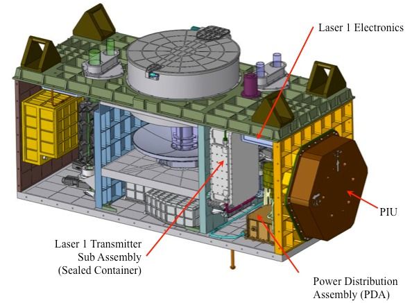
There are many technology “firsts” associated with the CATS payload. The CATS instrument provides a first in-space
demonstration of high repetition rate lasers for Earth remote sensing. Operating at 5000 pulses per second, the CATS
lasers emit a pulse every 1.5 m along-track. Coupled with photon-counting detectors, the attainable detection sensitivity
is being demonstrated on-orbit. Moreover, the temporal-spatial resolution being demonstrated is providing
unprecedented detail of atmospheric structure, on par with data quality from aircraft-based instruments. The Fabry-Perot
interferometer in the high spectral resolution channel will prototype high-fidelity tunable spectral filtering for future
Earth Science applications.
Many of the hardware components in the CATS instrument have heritage in either NASA’s Small Business Innovative
Research (SBIR) program and/or NASA’s Earth Science Technology Office (ESTO). The nature of the CATS project
also allows use of commercial-off-the-shelf (COTS) hardware, notably the photon-counting detectors, optics, and
mechanisms.
A primary aspect of the CATS project was to demonstrate the ISS as a suitable platform for NASA-developed external
payloads that are intended for near-continuous operation. While the ISS platform promised a unique capability for
demonstrating new technologies in space and at relatively low cost, it was up to CATS to provide proof as an end-to-end
test. As one of the first NASA external payloads for ISS (and the first NASA-developed payload for the JEM-EF), and
the first NASA payload to use the JEM-EF cooling loop, there was a steep learning curve. In the end, CATS has paved
the way for future payloads by defining and refining ISS processes, by sorting out interface requirements, and by testing
the limits of many of the ISS safety processes.
3. THE CATS INSTRUMENT
As a payload for the JEM-EF on ISS, CATS is not overly constrained by mass or cooling concerns. The standard JEM-
EF payload volume is 1.5 x 1 x 0.8 m, and is allowed up to 500 kg. Use of the JEM-EF coolant loop eliminates need for
large radiators and complete reliance on conductive cooling. Having only minimal constraints on mass, power, etc., is
obviously a key to keeping costs low for ISS payloads, compared to free-flyer instruments where every ounce and every
Watt can be a driving consideration. In fact, the cost and complexity of an ISS payload is significantly reduced over a
free-flyer satellite owing to the fact that the ISS provides the equivalent of a “spacecraft bus.”
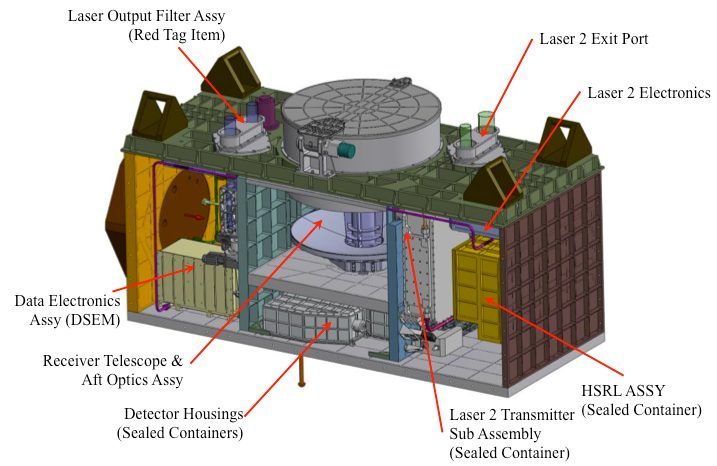
A schematic of the CATS payload is shown in Figure 1. Two lasers (partly for redundancy, partly to test different
technologies), a 60-cm beryllium telescope, and detector boxes comprise the majority of the hardware.
The primary instrument parameters are given in Table 1, below. As with CPL, the field of view has to be small to avoid
excessive background sunlight that would overwhelm the detectors. This necessitates good optical design and, to ensure
success, an active boresight alignment mechanism is provided on each of the receiver fields of view. Active alignment is
provided by pairs of counter-rotating Risley prisms mounted in COTS mechanisms.
From the outside, the payload is simply a blanketed box, as shown in Figure 2. The ISS interfaces for robotic operations
and power/data are identified.
4. INITIAL DATA EXAMPLES
CATS data (at 60 m vertical resolution and ~350 m horizontal resolution), is received from the ISS continuously and in
near real-time (with the exception of loss-of-signal (LOS) periods that can range from 5 to 50 minutes). Data are
collected, corrected for communication artifacts (i.e. duplicate or missing data) and sorted to produce granules that span
half an ISS orbit (approximately 45 minutes). The raw data is then geo-located, normalized to laser energy, and
annotated with ancillary information to create the normalized relative backscatter (NRB).
Proc. of SPIE Vol. 9612 96120A-2
Downloaded From: http://proceedings.spiedigitallibrary.org/ on 09/24/2015 Terms of Use: http://spiedigitallibrary.org/ss/TermsOfUse.aspx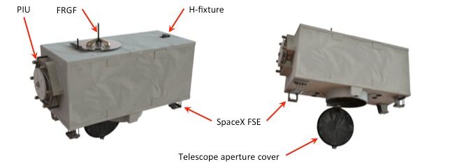
Laser Output Filter Assy
                                                                Laser 1 Electronics                 (Red Tag Item)                            Laser 2 Exit Port

                                                                                                                                                     Laser 2 Electronics

                                                                                      Data Electronic
                                                                             PIU       Assy (DSEM)

                         Laser 1 Transmitter                                             Receiver Telescope &
                                                                                              Aft Optics Assy
                                                                                                                /
                              Sub Assembly                                                                                                           HSRL ASSY
                          (Sealed Container)                                                        Detector Housings            Laser 2 Transmitter (Sealed Container)
                                                               Power Distribution
                                                                                                   (Sealed Containers)           Sub Assembly
                                                               Assembly (PDA)
                                                                                                                                 (Sealed Container)

                    Figure 1: Schematic of CATS payload, showing primary internal components. Payload volume is 1.5 x 1 x 0.8 m.

                    Table 1: CATS instrument parameters
                                       Laser 1 Type                                                                 Nd: YVO4
                                               Laser 1 Wavelengths                                              532, 1064 nm
                                               Laser 1 Rep. Rate                                                       5000 Hz
                                               Laser 1 Pulse Energy                                        ~1 mJ/wavelength
                                               Laser 2 Type                                                Nd: YVO4, seeded
                                               Laser 2 Wavelengths                                         355, 532, 1064 nm
                                               Laser 2 Rep. Rate                                                       4000 Hz
                                               Laser 2 Pulse Energy                                        ~2 mJ/wavelength
                                               Telescope Diameter                                                      60 cm
                                               View Angle                                                       +/-0.5 degrees
                                               Telescope FOV                                                110 microradians

                                                                         Telescope aperture cover

                    Figure 2: CATS payload exterior view, showing ISS interface hardware.

                                                                    Proc. of SPIE Vol. 9612 96120A-3

Downloaded From: http://proceedings.spiedigitallibrary.org/ on 09/24/2015 Terms of Use: http://spiedigitallibrary.org/ss/TermsOfUse.aspx
The near real time and continuous data downlinking provided by the ISS allows CATS data to be processed as quickly as
3-6 hours after collection. This allows CATS data to be incorporated into the data assimilation process of aerosol
forecast models. Processing of the CATS data products in Mode 1 began in February 2015 and include:
• Level 1B: Data that have been calibrated, annotated with ancillary meteorological data, and processed to sensor
units. The CATS Level 1B data (attenuated total backscatter and depolarization ratio) is archived as Level 1
data at the raw CATS resolutions.
• Level 2: Geophysical parameters derived from Level 1 data, such as the vertical feature mask, profiles of cloud
and aerosol properties (i.e. extinction, particle backscatter), and layer-integrated parameters (i.e. lidar ratio,
optical depth).
These products and corresponding browse images are available at the CATS website (cats.gsfc.nasa.gov).
The CATS Level 1B and 2 data processing algorithms rely heavily on heritage from existing airborne and space-based
lidar systems, such as CPL, ACATS, and the Cloud-Aerosol Lidar Infrared Pathfinder Spaceborne Observations
(CALIPSO) satellite.3 Given the technology demonstration aspect of Mode 2, this data will be processed differently than
the other two modes. The HSRL data processing algorithms will be very similar to those used for the ACATS
instrument.2
15S CATS 5 3 2 nm Attenuated Total Occkscctter; I I Feb. 2015
Right FOV, ResoluQon: 60 m(wtieol). I{em (horìionld)
1.0e-02
7,74-03 Ll
i
.Y.
S.Se-03 ¡,
ä
3,3e-03
1Ae-03
ISS CATS 1084 nm Oepolori2otion Rotic: 11 Feb, 2015
Right FOV, Wielded, Resolution: 60 m (vertical], 1 ten (horisonlol)
11.43, -01
2.0e-01
0,014-00
-0.00 -9,99 -29,9!1
Loltude (degrees)
Figure 3: CATS 532 nm attenuated total backscatter (top panel) and 1064 nm depolarization ratio (bottom panel)
from 11 February 2015 as the ISS passed over Africa. This is the first science image from CATS.
Proc. of SPIE Vol. 9612 96120A-4
Downloaded From: http://proceedings.spiedigitallibrary.org/ on 09/24/2015 Terms of Use: http://spiedigitallibrary.org/ss/TermsOfUse.aspxThe 532 nm CATS data is calibrated by normalizing the NRB signal to the 532 nm molecular backscatter signal in a
fixed calibration region.4,5 The CATS calibration region is 23-27 km, starting 1 km below the top of the CATS data
frame (28 km). The aerosol loading in this region is computed using CALIPSO data and applied to the calibration. The
CATS NRB signal is averaged to 3 minutes at night and 20 minutes during daytime operation to reduce uncertainty in
the calculation. During nighttime data collection, the 1064 nm calibration constant can be computed using an identical
approach as the 532 nm calculation. However during daytime operation, the 1064 nm signal is calibrated using the 532
nm signal and backscatter from ice clouds, similar to CALIPSO at 1064 nm.6 The depolarization gain ratio, which
describes the relative gain between polarization channels, is computed for both 532 and 1064 using the same algorithms
as CALIPSO.7
The CATS laser was first operated on-orbit on 5 February 2015. After initial telescope alignment procedures, semi-
continuous CATS operation began 10 February 2015, with occasional interruptions due to spacecraft dockings at the
ISS. One of the first orbits of CATS data collection occurred as the ISS flew over Africa on 11 February 2015 during
local nighttime hours (00:59 to 01:19 UTC). Figure 2 shows the CATS 532 nm attenuated total backscatter (km-1 sr-1)
with Saharan dust as high as 5 km (30N to 5N), thin cirrus clouds that extend above 17 km (12N to 1S), and smoke from
biomass burning (20S to 30S) in South Africa. The 1064 nm depolarization ratio values of ~0.30 for dust and ~0.50 for
cirrus are consistent with CALIPSO and CPL historical data.
During the first week of CATS operations, the CPL instrument was flying on the NASA ER-2 out of Palmdale, CA.
Several CATS validation flights were coordinated such that the ER-2 was flying under the ISS ground track. Validation
flights were conducted during local twilight hours (10 February), daytime hours (17 and 20 February) and night (21
February). Cirrus clouds were present during the 10 and 21 February flights, while low-level stratocumulus clouds were
observed during the two daytime flights. Figure 4 shows a comparison of the CATS and CPL 1064 nm backscatter
profiles from the 21 February flight. Agreement of layer boundaries and surface return indicates the CATS ranging is
working properly.
CPL 1064 nm Attenuoted Total Bockscotter; 22 Feb. 2015
Nodir, Resolution, 30 m (verticol), 200 m (5orltontol)
OÁ075
.0050
0,0000
33,7 33,3 32,9 32,4 32,0 31,6 31,2
Latitude (degrees)
CATS and CPL Comparison, 22 Feb, 2015
ISS CATS 1064 nm Attenuated Total Backscatter; 22 Feb. 2015
Right FOV, Reselutrorg 60 m(yerf al), 350 m(hod7antol) CATS MB RFOV
CATS MB LFOV
CPL ATB
0.0100 Lalltude: 32,2 - 31,5
0,0076
.0050
.0026
0.0000
33.7 33.3 32.8 32,4 32.0 31.6 31.2
Latitude (degrees) -0,001 0,006 0,013 0,020
Backscatter (km-1
Figure 4: Data from 21 February 2015 over the Pacific Ocean at night. Top image is 1064 nm backscatter profiles
from the airborne Cloud Physics Lidar (CPL) on the ER-2. Bottom image is coincident 1064 nm backscatter from
CATS. The cloud boundaries and ocean surface heights agree well, as shown in the average profile on the right.
Proc. of SPIE Vol. 9612 96120A-5
Downloaded From: http://proceedings.spiedigitallibrary.org/ on 09/24/2015 Terms of Use: http://spiedigitallibrary.org/ss/TermsOfUse.aspx5. CONCLUSION
Launched on January 10, 2015, and first operated on February 5, the CATS instrument is now on-orbit and operating
from the ISS. Data is collected near-continuously, within limits of ISS operational constraints.
As a demonstration of a build-to-cost/build-to-schedule instrument development CATS succeeded and is delivering
useful science data for low cost. As a first demonstration of spaceborne high repetition rate, photon-counting
atmospheric lidar CATS has succeeded. The data and data quality from CATS is meeting expectations compared to
modeled performance and as validated using aircraft instruments. As a pathfinder for NASA-developed ISS payloads
CATS also succeeded, as demonstrated by selections of new ISS payloads via the Earth Venture solicitations. These
new payloads are all benefitting from the process improvements made possible by CATS.
Operation to-date clearly demonstrates that the CATS experiment in managing a small project has succeeded. Similarly,
many of the technology aspects of the payload are proving successful. Data quality is good and is demonstrating the
high spatial-temporal resolution possible with use of high repetition-rate lasers.
More information and access to CATS data can be found at the CATS web page: http://cats.gsfc.nasa.gov
ACKNOWLEDGMENTS
The CATS instrument was funded by the ISS Program within NASA’s Human Exploration and Operations Mission
Directorate (HEOMD). Science algorithms and data processing are funded by NASA’s Earth Science Division in the
Science Mission Directorate (SMD).
REFERENCES
[1] McGill, M. J., D. L. Hlavka, W. D. Hart, V. S. Scott, J. D. Spinhirne, and B. Schmid, “The Cloud Physics Lidar:
Instrument description and initial measurement results,” Appl. Opt., 41, 3725-3734 (2002).
[2] Yorks, J. E., and coauthors, “The Airborne Cloud-Aerosol Transport System: Overview and Description of the
Instrument and Retrieval Algorithms,” J. Atmos. Oceanic Technol., 31, 2482–2497, doi:10.1175/JTECH-D-14-
00044.1 (2014).
[3] Winker, David M., and coauthors, “Overview of the CALIPSO Mission and CALIOP Data Processing Algorithms,”
J. Atmos. Oceanic Technol., 26, 2310–2323 (2009).
[4] McGill, M. J., M. A. Vaughan, C. R. Trepte, W. D. Hart, D. L. Hlavka, D. M. Winker, and R. Kuehn, “Airborne
validation of spatial properties measured by the CALIPSO lidar,” J. Geophys. Res., 112, D20201,
doi:10.1029/2007JD008768 (2007).
[5] Powell, Kathleen A., and coauthors, “CALIPSO Lidar Calibration Algorithms. Part I: Nighttime 532-nm Parallel
Channel and 532-nm Perpendicular Channel,” J. Atmos. Oceanic Technol., 26, 2015–2033 (2009).
[6] Vaughan, M. A., Z. Liu, M. J. McGill, Y. Hu, and M. D. Obland, “On the spectral dependence of backscatter from
cirrus clouds: Assessing CALIOP’s 1064 nm calibration assumptions using cloud physics lidar measurements,” J.
Geophys. Res., 115, D14206, doi:10.1029/2009JD013086 (2010).
[7] Liu, Z., M. McGill, Y. Hu, C. A. Hostetler, M. Vaughan, and D. Winker, “Validating lidar depolarization calibration
using solar radiation scattered by ice clouds,” Geosci. Remote Sens. Lett., 1, 157–161,
doi:10.1109/LGRS.2004.829613 (2004).
Proc. of SPIE Vol. 9612 96120A-6
Downloaded From: http://proceedings.spiedigitallibrary.org/ on 09/24/2015 Terms of Use: http://spiedigitallibrary.org/ss/TermsOfUse.aspxYou can also read