Defining Connected Bike Networks - Pedestrian & Bicycle ...
←
→
Page content transcription
If your browser does not render page correctly, please read the page content below
Defining Connected
Bike Networks
PBIC Info Brief • May 2017
What is a “connected
bike network”?
A connected bike network provides a safe and
comfortable transportation experience, enabling
people of all ages and abilities to get where
they want to go. Consider the road network
as an example. When people get in a car to go
somewhere, they rarely give much thought to
whether the road can get them to their destination
or if they feel secure taking children with them. In
other words, the road network for motor vehicles
in the U.S. connects to the places people need
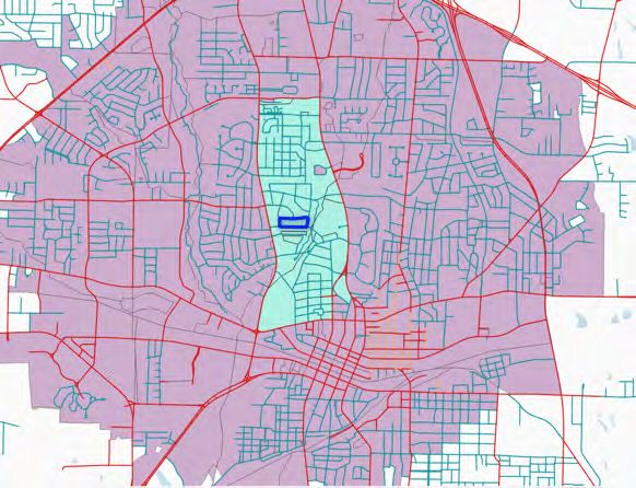
to go in a generally consistent, reliable, and Figure 1. Low-Stress (blue) and high-stress (red) bikeshed
in Longview, TX
comfortable way.
Bike networks in the U.S. rarely function the A “connected bike network” functions just like the
same way. In many places, it isn’t a given that road network. It offers people multiple ways to
people can get from one place to another on a get where they want to go and a safe, comfortable
bike on a network that feels safe. For example, experience for people of all ages and abilities. In
Figure 1 shows the area accessible by bike from order to meet the needs of everyone, a connected
the highlighted census block using the low stress bike network should be, by definition, low-stress
(blue) and high stress (red) network. Notice that and high-comfort. Such a network can include a
busy arterials create a boundary around the low variety of facilities, from a protected bike lane or
stress bikeshed. Additionally, it isn’t uncommon a quiet neighborhood street to a shared-use path.
for a low-stress bike facility, like a protected bike High-stress facilities such as a conventional bike
lane (also known as a separated bike lane or cycle lane on a street with a 45 mph speed limit may not
track), to end abruptly, leaving a rider on a street meet the needs of people of all ages and abilities
that feels unsafe by virtue of the volume and and would therefore not be considered part of a
speed of motor vehicle traffic. Research indicates connected bike network. In this conceptualization,
that concern about safety around motor vehicles a connected bike network gets people where
is a key barrier to increasing ridership they want to go and offers a comfortable way
(PeopleForBikes, 2014). to get there.
1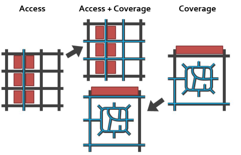
Why do connected bike                                    as a cornerstone national goal. FHWA has also
                                                         recently published numerous planning and design
networks matter?                                         resources to help partners and stakeholders
                                                         implement connected networks at the local,
Connected bike networks increase ridership and           regional, and state level.
improve safety. In 2007, the city of Seville, Spain
focused on connecting a bike network across the          Just north of the U.S.-Canada border is an excellent
entire city, fully separating network facilities from    North American example of a city investing rapidly
auto traffic to make it safe and comfortable for         in a connected low-stress network and accelerating
people of all ages and abilities to ride. Between 2006   the growth of biking. Vancouver started building
and 2013, the network grew from just 12 km of            a downtown network of protected bike lanes
protected bike lanes to 152 km spanning the entire       in 2010 in the face of intense opposition from
city. With these improvements (and other bike-           businesses worried about parking loss and
friendly policies and programs), the city observed       residents concerned about congestion. From 2011
a 435 percent increase in the number of bike             to 2015, bike commuting in the city increased
trips and a 61 percent drop in bike-motor vehicle        from 4 percent (National Household Survey for
crash rates (Marqués & Hernández-Herrador, 2017).        Vancouver City, Statistics Canada, 2011) to 10
                                                         percent (Annual Monitoring Report & Safety Action
After 20 to 30 years of what are at times                Plan, 2016). Vancouver’s downtown business
piecemeal street-by-street improvements, a               association now praises the network and the
similar trend is happening in the U.S. Some of the       mayor, a vocal supporter of bicycle improvements
country’s leading cities on bike infrastructure are      and programs, was reelected twice.
shifting their attention toward linking individual
projects into complete, connected multimodal             These examples demonstrate the value in shifting
networks. For example: In 2014, Austin, TX, and          away from focus on the “low-hanging fruit” of
Seattle, WA, set out to address traffic congestion       bike infrastructure – streets with excess auto
by updating their bike master plans to prioritize        capacity or unused parking – and toward the most
mode shift. Their revised plans call for improving       important roads for bicycle connectivity, even if
networks of streets until it becomes attractive for      they require difficult tradeoffs. These changes may
people not currently biking to choose to do so.          be more politically difficult, but if chosen well they
Tallahassee, FL, is currently repurposing travel         promise bigger payoffs in ridership and safety – a
lanes on key arterials and spur streets to create        promise supported by research.
a network of protected bike lanes and off-street
paths leading from Florida State University through      Pucher and Buehler (2016) analyzed data from 10
downtown to the Gulf coast, 16 miles away.               American cities that have focused efforts to improve
New York City, NY, has been working consistently         and connect their bike networks over the last 15
to connect its network; in 2016 it closed two key        years: Portland, OR; Washington, DC; New York, NY;
links to motor vehicle traffic, creating a single        Minneapolis, MN; San Francisco, CA; Cambridge, MA;
nine-mile string of protected bikeways from              Chicago, IL; Seattle, WA; Los Angeles, CA; and
Brooklyn up the length of Manhattan to the Bronx.        Philadelphia, PA. Across all 10 cities there is evidence
                                                         of increased ridership with a simultaneous
These efforts have been supported at the                 reduction in crashes, fatalities, and severe injuries.
national level. For example, the Federal
Highway Administration (FHWA) published a                The authors and others are quick to point out
Strategic Agenda for Pedestrian and Bicycle              that more research is needed and that not all
Transportation that includes connected networks          bike facilities are created equal, either in terms

2
Figure 2. Ease of Access
and Coverage
Legend:
Blue lines indicate low
stress network segments
Black lines indicate high
stress network segments
Red boxes indicate
destinations
of increasing ridership or improving safety. For
example, a study of 74 U.S. cities found that dense
How do we measure
bike networks with direct connections were the connected bike networks?
most likely to increase bike commuting (Schoner &
Levinson, 2014). Similarly, a study examining a Two key factors that define connected bike networks
variety of bike facility types in Vancouver and Toronto are connectivity and comfort. Following are the
found that the odds of a crash occurring on protected most common measurement approaches to each.
bike lanes on roads without parked cars was 89
percent lower than on major streets (with parked Connectivity
cars and no bike infrastructure). The odds of a
crash occurring on low volume residential streets Connectivity reflects the degree to which people
without any bicycle facilities was 56 percent lower can get where they want to go on the bike network.
than on major streets (Teschke et al., 2012). It is composed of two key factors, access and
coverage. Access reflects the degree to which people
To summarize: connected bike networks can grow can get to key destinations on the network, and
ridership and improve safety. Best of all, people coverage reflects ease with which all destinations
want them. A recent poll conducted by Princeton can be accessed on the network (see Figure 2).
University (2016) found that 58 percent of Americans
support an increase in funding for biking and The key feature of access measures is that they
walking, up from 47 percent in 2012. Another require the prioritization of particular destinations
30 percent support maintaining current levels of (Handy & Niemeier, 1997). In contrast, measures
funding for walking and biking. These priorities are of coverage reflect how well the network gets
reflected in U.S. cities with initiatives like Vision Zero, people to all locations throughout the network
and at the highest levels of government. In fact, (Rayfield et al., 2011). The strengths of coverage
during her confirmation hearing, U.S. Secretary of approaches complement the weaknesses of access
Transportation Elaine Chao stated that “safety will approaches and vice versa. For example, coverage
continue to be the primary objective.” measures don’t require assumptions about where
3Traffic Type of LTS Level of Description
Stress Transportation Comfort
Tolerance Cyclist*
No Way, No How Not Applicable Not interested in riding a bicycle for transportation.
Less Interested but LTS 1(incl. Little tolerance for traffic stress with major concerns for safety. Strongly
Concerned children) prefer separation from traffic on arterials by way of protected bike lanes
LTS 2 (not and paths.
incl. children)
Enthused and LTS 1, LTS 2, Some tolerance for traffic stress. Confident riders who will share lanes with
Confident LTS 3 cars, especially on rural roads, but prefer separated bike lanes, paths, or
paved shoulders on roads with higher traffic levels.
Strong and LTS 1, LTS 2, High tolerance for traffic stress. Experienced riders who are comfortable
More Fearless LTS 3, LTS 4 sharing lanes on higher speed and volume arterials. These riders may use
protected bike lanes and paths if available but will ride without them as well.
Figure 3. Level of Traffic Stress and the Four Types of Bicyclists
*These category names were developed by Roger Geller of the City of Portland Office of Transportation in 2006.
people travel, but they don’t account for factors Although LOS approaches have proven useful in
like land use. As a result, the two measures are measuring bicycle network comfort, they share
best used in conjunction with one another. some common issues. First, data limitations are
a barrier for many agencies in that they don’t
Comfort collect the relevant data on a community-wide
basis. Second, existing LOS measures only take
Comfort reflects the degree to which people feel into account a limited number of facilities – not
safe from contact with motor vehicles while riding including protected bike lanes – so emerging
on the bike network. There are a variety of “Level facilities like protected bike lanes are difficult to
of Service” (LOS) measures that differ with respect score. Finally, LOS measures aren’t related to a
to the specific method of calculation, but all specific standard of comfort, so we don’t know if
generate a comfort score based on characteristics the mainstream population would feel comfortable
of the roadway (LaMondia & Moore, 2014). on a given segment.
PlacesForBikes (e.g., primary, secondary, etc.), type of bike
Bike Network Analysis facility, speed limits, number of lanes, parking,
and width of bike facilities. Intersections are scored
As part of its PlacesForBikes program, taking into account the classifications of crossing
PeopleForBikes is developing a Bike Network streets, intersection control, number of crossing
Analysis (BNA) designed to quantify the lanes, crossing speed limits, and median islands.
degree to which people can get to key destinations
on a comfortable, connected bike network. Key Although there are limitations to this approach
destinations include core services (e.g., grocery (e.g., data availability in OSM), the goal is to
stores and healthcare), opportunity (e.g., jobs provide a tool that all communities can use to
and education), transit, recreation, and retail. measure the quality of their bike networks and
track progress as they move toward building
The tool is based on OpenStreetMap (OSM) and complete, connected bike networks. The
uses a modified Level of Traffic Stress approach PlacesForBikes Network Connectivity scoring is
taking into account factors such as road classification open-source so that anyone can use or modify it.
4To address these limitations, Mekuria et al. (2012)
FHWA’s Measuring Multimodal
developed a method of classifying road segments
based on how comfortable different types of users
Network Connectivity Project
should feel on them. The Level of Traffic Stress
FHWA is currently working on a project on
(LTS) method uses four categories of stress that
Measuring Multimodal Network Connectivity.
roughly correspond to Roger Geller’s (2006) four
This project will synthesize and present a range
categories of bicyclists (see Figure 3). One of of options for measuring multimodal network
its differentiating characteristics is that the LTS connectivity and tracking change over time.
approach assigns the worst rating encountered on It will result in a national guidebook to help
a trip to the entire trip. For example, if a trip transportation agencies select connectivity
follows mostly low stress roads but requires a measures based on the data and technical
stressful crossing that rates LTS 4, the whole trip tools available, scale of analysis, and point
receives a rating of LTS 4, meaning that only the in the planning process. The guidebook
most committed riders would be expected to make will be grounded in real-life examples from
the trip. transportation practice, including five case
studies based on in-depth technical assistance
Because of its explicit connection to types of provided to the following agencies:
riders, intuitive interpretation, and usage of
available data, the LTS approach has become a 1. Fort Collins, CO
standard for measuring the comfort of bicycle 2. Baltimore, MD
networks. Since its original publication, research 3. Atlanta Regional Commission (Metropolitan
has built on the LTS framework. For example, Planning Organization)
Lowry et al. (2016) simplified and extended 4. Metro (Portland Region Metropolitan
the original LTS measurement model with less Planning Organization)
stringent data requirements and incorporated
5. Caltrans District 4 (State Department of
newer facility types such as protected and buffered
Transportation region serving San Francisco/
bike lanes. Cities and advocacy organizations Oakland/Marin)
are adapting the LTS methodology to help them
understand and improve the quality of their local
The resource will be published in fall 2017 and
bicycle networks (see sidebars for examples).
will be available on FHWA’s website.
What are we
bike networks to the transportation planning and
working toward? decision-making process.
The shared goal is to accelerate progress in Cities are also refocusing their efforts to build
building complete, connected bike networks, a complete networks – programs like Complete
concept that is gaining momentum in the U.S. As Streets are an example. There are also
described in the sidebar above, FHWA is focusing several programs offered by organizations like
on how connected bike networks address key PeopleForBikes and the League of American
goals such as improved safety across all modes, Bicyclists that foster the development and
better transportation system efficiency, and institutionalization of connected bike networks.
economic development. To inform this effort, The research is clear, connected bike networks
FHWA developed a Bike Network Mapping Idea increase ridership and ultimately create safer
Book that links the idea of complete, connected places for everyone.
5References and Marqués, R. & Hernández-Herrador, V. (2017). On
the effect of networks of cycle-tracks on the risk of
Useful Resources cycling. The case of Seville. Accident Analysis and
Prevention, 102, 181-190.
Annual Monitoring Report & Safety Action Plan
(2016). Presentation. Vancouver, British Columbia. Mekuria, M.C., Furth, P.G. & Nixon, H. (2012).
Retrieved from (http://council.vancouver. Low-Stress Bicycling and Network Connectivity.
ca/20160504/documents/pspc2-presentation.pdf). (Report No. 11-19). San Jose, CA: Mineta
Transportation Institute.
Dixon, L. B. (1996). Bicycle and pedestrian
level-of-service performance measures and National Household Survey for Vancouver City
standards for congestion management systems. (2011), Statistics Canada.
Transportation Research Record: Journal of
the Transportation Research Board No. 1538, National Poll: Americans Support Increasing
Transportation Research Board of the National Funding for Sidewalks, Bike Lanes and Paths
Academies, Washington, D.C., 1-9. (2016). Princeton Survey Research Associates
International.
Geller, R. (2006). Four Types of Cyclists. Portland
Office of Transportation. Retrieved from (https:// Pucher, R. & Buehler (2016). Safer Cycling Through
www.portlandoregon.gov/transportation/ Improved Infrastructure. American Journal of
article/264746). Public Health, 106(12), 2089-2091.
Handy, S.L. & Niemeier. D.A. (1997). Measuring Rayfield, B., Fortin, M., & Fall, A. (2011).
Accessibility: An Exploration of Issues and Connectivity for conservation: a framework to
Alternatives, Environment and Planning. A classify network measures. Ecology, 92 (4), 847-858.
29:1175-94.
Schoner, J.E. & Levinson, D.M. (2014). The missing
LaMondia, J.L. & Moore, N. (2014). Comparing link: bicycle infrastructure networks and ridership
bicycle level of service measures, roadway in 74 US cities. Transportation, 41, 1187-1204.
characteristics, and perceived bike route suitability.
Submitted for Presentation at the 94th Annual Teschke K., Harris M.A., Reynolds C.C., et al. (2012).
Meeting of the Transportation Research Board. Route infrastructure and the risk of injuries to
bicyclists: a case-crossover study. American
Lowry, M.B., Furth, P., & Hadden-Loh, T. (2016). Journal of Public Health, 102 (12), 2336–2343.
Low-Stress Neighborhood Bikeability Assessment
to Prioritize Bicycle Infrastructure. Submitted for U.S. Bicycling Participation Benchmark
Presentation at the 95th Annual Meeting of the Report (2014). PeopleForBikes (http://www.
Transportation Research Board, Washington D.C. peopleforbikes.org/page/s/download-the-report).
Prepared by Jennifer Boldry, Ph.D., Michael Anderson, and Martha Roskowski (PeopleForBikes)
SUGGESTED CITATION: Boldry, J., Anderson, M., and Roskowski, M. (May 2017).
Defining Connected Bike Networks. Pedestrian and Bicycle Information Center. Chapel Hill, NC.
DISCLAIMER: This material is based upon work supported by the Federal Highway Administration
under Cooperative Agreement No. DTFH61-16-H-00029. Any opinions, findings, and conclusions or
recommendations expressed in this publication are those of the Author(s) and do not necessarily
6reflect the view of the Federal Highway Administration.You can also read