Ecological Assessment of the Illinois River Watershed - February 2022
←
→
Page content transcription
If your browser does not render page correctly, please read the page content below
Ecological Assessment of the Illinois
River Watershed
February 2022
Thank you to our current Ecological Assessment partners.

And thank you to past assessment partners who have made this multi-year study possible.

We would like to express our appreciation to the many contributors of this report including Dr. Nicole
Hardiman, Justin Nachtigal, Matt Taylor, Candice Miller, the staff at Grand River Dam Authority (GRDA)
water quality laboratory, and the many individuals who volunteered their time to make this research
possible current and past. We also want to thank the landowners throughout Oklahoma and Arkansas
who allowed us to access the river and its subwatersheds across their properties.

Mission
IRWP works to improve the integrity of the Illinois River through public education, community outreach,
and implementation of conservation and restoration practices throughout the watershed.

Vision
The Illinois River and its tributaries will be a fully functioning ecosystem, where ecological protection,
conservation, and economically productive uses support diverse aquatic and riparian communities, meet
all state and federal water quality standards, promote economic sustainability, and provide recreational
opportunities.

Contact
221 S. Main Street
Cave Springs, AR 72718
Phone: (479)203-7084
www.irwp.org
https://www.facebook.com/IllinoisRiverWatershedPartnership

2022 Ecological Assessment of the Illinois River Watershed                                         1
Table of Contents
Introduction .................................................................................................................................................. 3
Methods ........................................................................................................................................................ 4
Summary of Findings..................................................................................................................................... 4
Oklahoma ...................................................................................................................................................... 7
   Barren Fork ............................................................................................................................................... 7
   Caney Creek .............................................................................................................................................. 9
   Flint Creek ............................................................................................................................................... 10
   Town Branch ........................................................................................................................................... 13
Arkansas ...................................................................................................................................................... 15
   Clear Creek .............................................................................................................................................. 15
   Moore’s Creek ......................................................................................................................................... 17
   Muddy Fork ............................................................................................................................................. 19
   Sager Creek ............................................................................................................................................. 21
Conclusion ................................................................................................................................................... 23
References .................................................................................................................................................. 23

2022 Ecological Assessment of the Illinois River Watershed                                                                                             2
Introduction
The Illinois River Watershed (IRW), located in Northwest Arkansas and eastern Oklahoma, includes
just over 1 million acres, one of the fastest growing metropolitan areas in the country. The IRW is
also home to Arkansas’ and Oklahoma’s top producing counties for chicken production (Benton and
Delaware County) (USDA, 2021). Benton County, Arkansas is also the top producer in the state for
cattle and calves (USDA, 2021). The watershed is extremely ecologically diverse, containing
extensive cave systems, upland and lowland prairies, oak-hickory dominant forests, and the
northern and western most portions of the Boston Mountains. While the watershed is mostly rural,
consisting of forest and pasture lands, the development of the Fayetteville-Springdale-Rogers
metropolitan area is placing additional environmental pressure on the watershed as the headwaters
of several major tributaries are located in this area. In fact, many of the towns in the region were
first established due to the presence of the many springs and creeks within the IRW. Important
management considerations within the Illinois River Watershed include erosion and sedimentation,
nutrient loading, and bacteria impairments.
The watershed is considered a priority subwatershed by the States of Arkansas and Oklahoma, as
well as the Cherokee Nation, and it is monitored regularly by many state and federal agencies.
However, monitoring locations are widely dispersed geographically, making management decisions
challenging at the subwatershed scale based on monitoring data alone. The three main goals for this
project were:
1. Gain an improved ecological understanding of the entire watershed.
2. Provide long-term trend analysis of watershed condition at small geographic intervals.
3. Identify priority areas for management activities such as education and outreach campaigns,
as well as conservation and restoration projects.
We believe this report, its findings, and management recommendations can assist city and county
elected officials and relevant staff, business leaders, and interested landowners to make decisions
on land use and management decision, stormwater management, and natural resource issues across
the watershed.
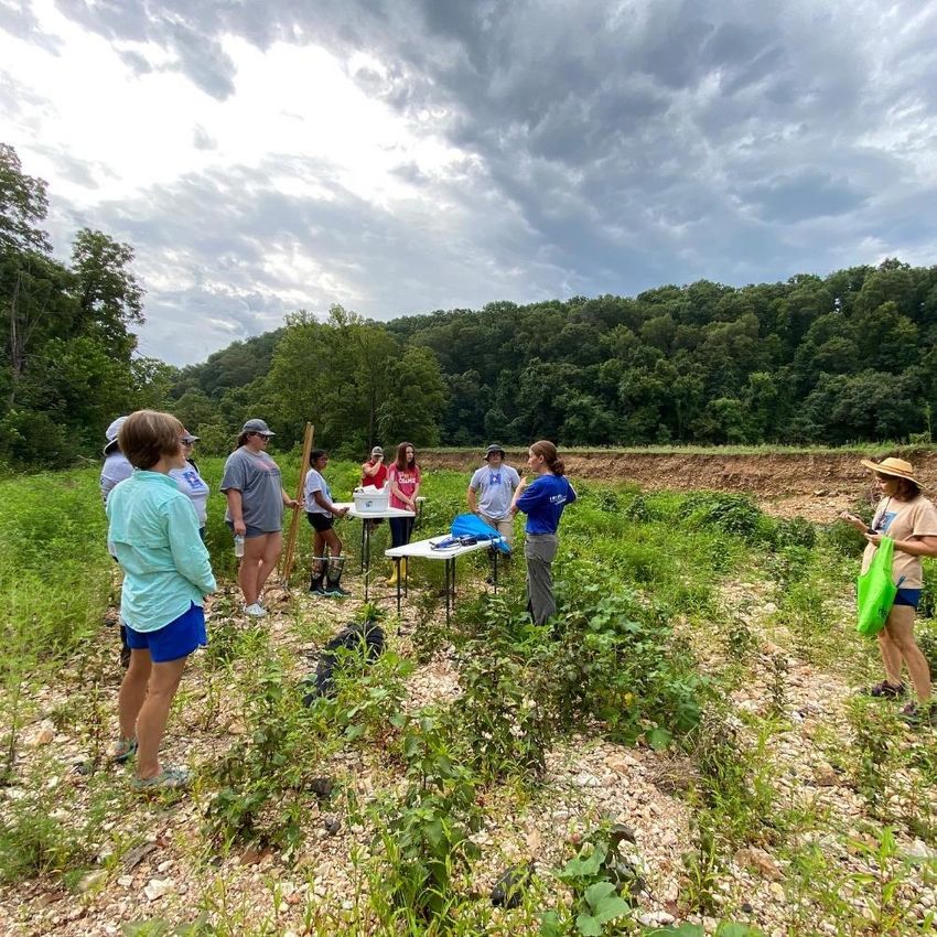
The project assessed in-stream, streambank, and riparian ecological condition and
macroinvertebrate diversity in eight subwatersheds (four in Arkansas and four in Oklahoma). All
subwatersheds are designated as impaired by each State’s Departments of Environmental Quality.
The four subwatersheds in Arkansas have previously been identified as high contributors to
sediment and nutrient loading in modeling studies. In 2018 and 2019, IRWP partnered with local
schools’ Environmental and Spatial Technology (EAST) programs to assess twenty-one locations in
April, August, and November of each year. In 2020 and 2021, IRWP partnered with Oklahoma
Conservation Commission’s Blue Thumb staff and volunteers to assess twelve locations during the
same months. This report summarizes findings from the first four years of study. The assessment in
Arkansas will be repeated in 2022 and it is the goal of the program to assess the same Arkansas sites
in even years and Oklahoma sites in odd years on an on-going basis.
2022 Ecological Assessment of the Illinois River Watershed 3
Methods
Stream Habitat Assessment:

    •   Utilized EPA’s Volunteer Stream Monitoring: A Methods Manual (publication number EPA
        841-B97-003). Section 4.1: Stream Habitat Walk.
    •   300 feet stream reach subdivided into four, 75-foot sections.
    •   Each 75-foot section was observed by standing at the downstream-most end and looking
        upstream.
    •   For the purposes of data analysis, percent observations for each site were averaged across
        sections, then average across years.

Macroinvertebrate Diversity

    •   Utilized EPA’s Volunteer Stream Monitoring: A Methods Manual (publication number EPA
        841-B97-003), section 4.2: Streamside Biosurvey.
    •   Sampling consistent of a composite of three, three-foot riffle locations across the entire 300
        foot stream reach.
    •   Macroinvertebrate identification based on Izaak Walton League of America – Stream Insects
        and Crustaceans.
    •   Macroinvertebrate score calculated using Arkansas Game and Fish Commission’s Stream
        Team method.
    •   One score was generated for each season and, for the purposes of data analysis, averaged
        across years.

Statistical Analysis:

    •   All analyses were performed in Microsoft Excel.
    •   Compared variables included macroinvertebrate diversity, composition of stream bottom,
        streamside cover, surrounding land use, and types of algae present.
    •   Regression analysis was used to examine relationships between each of the above habitat
        variables and diversity scores.
    •   T-tests were used to compare variables between Arkansas and Oklahoma.

Purposive sampling was used in selection of sites with a focus on diverse land use, land cover,
subwatershed integrity, and other characteristics. Below is a map of the Illinois River Watershed.

2022 Ecological Assessment of the Illinois River Watershed                                           4
Summary of Findings
    •    Oklahoma scored a higher average
         macroinvertebrate diversity score (24)
         than Arkansas (16) (Figure 1).
    •    Macroinvertebrate       diversity    was
         significantly higher across all Oklahoma
         sites when compared to Arkansas.
         (Figure 2)(OK sites: Barren, Caney, Flint,
         Town. AR sites: Clear, Muddy, Sager,
         Moore’s).
    •    In Arkansas, the sites with the lowest Figure 1: Average macroinvertebrate diversity in Arkansas
         diversity scores were found in Muddy and Oklahoma
         Fork and Clear Creek subwatersheds. The site with the highest diversity score in Arkansas was
         also found in Clear Creek subwatershed (Figure 3).
    •    In Oklahoma, the site with the lowest average diversity score was found in Barren Fork and
         the site with the highest average diversity score was found in Flint Creek (Figure 3).

  Figure 2: Average macroinvertebrate diversity across all subwatersheds.

  Figure 3: Average macroinvertebrate diversity across all sampling sites.

2022 Ecological Assessment of the Illinois River Watershed                                            5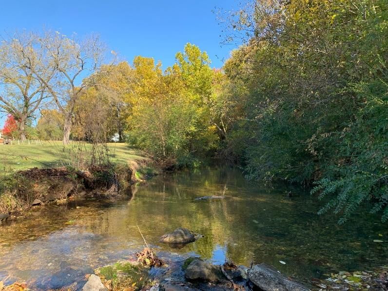
When examining relationships between diversity scores and habitat parameters:

     •      All significant relationships were weakly related (Table 1). This is likely due to the limited
            amount of data taken causing a spread in the analysis. It is expected that as our data set
            becomes more robust, we will see a strengthening relationship.
     •      There were positive relationships between diversity and presence of gravel and cobbles
            within the streambed. There were negative relationships between diversity and presence of
            silt, clay, and mud within the streambed, filamentous algae in the water column, and
            presence of trees along the streambank banks (Table 1).
     •      Due to the number of significant relationships, we have chosen to focus on the three
            significant streambed types for subwatershed analyses. Those are: gravel, cobbles, and
            silt/clay/mud (fig 4, 5, 6).
     •      The positive relationships between gravel, cobbles, and macroinvertebrate diversity is
            expected as these organisms use open spaces between substrates as habitat for protection
            and reproduction. The negative relationship with silt, clay, and mud is also expected. As a
            consequence of erosion, small soil particles can impact aquatic organisms’ ability to obtain
            oxygen. Additionally, these sediments fill open spaces between rocks that are important to
            these organisms’ survival.

For purposes of this report and its findings, management recommendations focus on reduction of
silt, clay, and mud from the immediate site, as well as from upstream land uses (which presumably
contribute silt, clay, and mud to the sampling site).
 Table 1: Regression analysis of all parameters considered in
 the EcoAssessment.
                                                   Relationship to Diversity
                                      Strong or Weak? Significant? Positive or Negative?
                   Slime Coating      Weak            Yes           None
                   Filamentous        None            Yes           None
        Algae
                   Clumps or Mats     None            No            None
                   No Algae           None            Yes           None                   Figure 6: Linear regression model of the relationship
                   Trees              Weak            Yes           Negative               between macroinvertebrates and the presence of gravel on
                   Bushes/Shrubs      None            Yes           Negative               the stream bottom.
                   Tall Grasses       None            Yes           Positive
                   Lawn               None            No            None
  Streamside Cover
                   Boulders/Rocks     Weak            Yes           Positive
                   Gravel/Sand        Weak            Yes           Positive
                   Bare Soil          None            No            None
                   Pavement/Structure None            No            Negative
                   Residential        None            No            None
                   Roads              None            Yes           None
                   Construction       None            No            None
      Land Use
                   Agriculture        None            No            None
                   Recreation         None            No            None
                   Other              None            No            None
                   Silt/Clay/Mud      Weak            Yes           Negative
                                                                                           Figure 5: Linear regression model of the relationship
                   Sand               None            Yes           Positive
                                                                                           between macroinvertebrates and the presence of
                   Gravel             Weak            Yes           Positive
   Streambottom                                                                            silt/clay/mud on the stream bottom.
                   Cobbles            Weak            Yes           Positive
                   Boulders           None            No            None
                   Bedrock            None            Yes           None
                   Percent Pool       Weak            Yes           Negative
   Stream Habitat Percent Riffle      Weak            Yes           Negative
                   Percent Run        None            Yes           None
                   Trees              None            No            None
                   Bushes/Shrubs      None            No            None
                   Tall Grasses       None            Yes           Positive
   Riparian Cover
                   Lawn               None            No            None
                   Boulders/Rocks     None            No            None                   Figure 4: Linear regression model of the relationship between
                   Gravel/Sand        None            No            None                   macroinvertebrates and the presence of cobbles on the
                                                                                           stream bottom.

2022 Ecological Assessment of the Illinois River Watershed                                                                                          6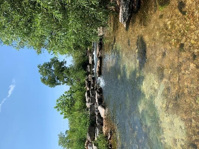
Oklahoma
The Oklahoma portion of the watershed is the focus of the 2021 EcoAssessment. The portion of the
watershed located in Oklahoma makes up approximately 54% of the entire Illinois River Watershed
(OCC, 2010). The Illinois River itself is designated as a State Scenic River and recognized as one of
Oklahoma’s most valuable water resources. In 1953, the Illinois River was impounded to form Lake
Tenkiller for the purposes of flood control and hydroelectric power. Lake Tenkiller is considered to
be one of the state’s most aesthetically appealing lakes (OCC, 2010), promoting various recreational
opportunities. The lake also serves as a drinking water source for many Oklahomans. The Illinois River
in Oklahoma is listed on Oklahoma’s Department of Environmental Quality 303d list of impaired
waters for bacteria, dissolved oxygen, total phosphorus, and chlorophyl a (Lake Tenkiller).

Four tributaries to the Illinois River were observed in this study – Barren Fork, Caney Creek, Flint Creek,
and Town Branch in Tahlequah. Continue reading below for our findings.

Barren Fork
The headwaters of Barren Fork begin in southern Washington county in Arkansas, however, most of
this subwatershed is in Oklahoma. The Barren Fork drainage basin covers more land area than the
main stem of the Illinois river and contains the largest piece of conserved land in
                                                                                    2020 Impairments
the Illinois River Watershed – the J.T. Nickel Preserve (owned and managed by        (Oklahoma DEQ)
The Nature Conservancy). This 17,000-acre Preserve consists of uplands and
                                                                                       Phosphorus
lowlands including upland prairies, oak/hickory dominant forest, and sustainably
managed pasture lands.
                                                      Table 2: Land use Change over time.
                                                                     Barren Fork Land Use Comparison
                                                                  1992 (%) 2016(%) 2019 (%) % Change (1992 - 2019)
                                                      Pasture/Hay    57        52        50           -7
                                                      Forest         40        40        40           0
                                                      Developed       1        6         7            6
                                                      Water          0.3      0.1       0.2          -0.1
                                                      Other           2        3         3            1
Figure 7: Land use in the Barren Fork subwatershed.

Data Summary
•     The Barren Fork subwatershed underwent a 6%
      increase in developed land area from 1992 to
      2019. This is likely caused by the conversion of
      pasture land (Table 2).
•     Barren Fork continued to maintain the lowest                    Figure 8: Average macroinvertebrate diversity in Oklahoma
                                                                      subwatersheds.
      macroinvertebrate score among the four
      watersheds surveyed in Oklahoma (Figure 8)
•     Barren 3 was found to sustain the lowest median
      macroinvertebrate population and the greatest
      variation in population observations. Barren 2

2022 Ecological Assessment of the Illinois River Watershed                                                                 7
sustains the highest median population
(Figure 9)
• Barren 1 and 3 show increased diversity while
Barren 2 shows decreased diversity from 2020
to 2021 (Figure 10)
• The presence of Silt/Clay/Mud stream bottom
substrate was observed to be relatively low
with a high amount of gravel and cobble –
desirable habitat for macroinvertebrates
Figure 9: Average macroinvertebrate score across Barren Fork sites.
(Figure 11).
Figure 10: Change in macroinvertebrate diversity from
Figure 11: Streambottom composition in the Barren Fork 2020 to 2021.
Subwatershed.
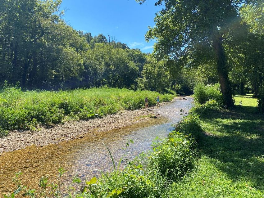
Below are images showing sites on Barren Fork with high and low macroinvertebrate diversity. Barren
2 (left) is the site that sustains the highest level of macroinvertebrate diversity. While there are signs
of active erosion as seen on the left stream bank, suitable habitat conditions for aquatic
macroinvertebrates remain intact as suggested by the data above. Barren 3 (right) sustains the lowest
level of macroinvertebrate diversity. There are no active indications of streambank erosion at this
site, however, a strong presence of gravel substrate and gravel bars indicate active erosion upstream.
Figure 12: Visual comparison of sites with high (left) and low (right) macroinvertebrate diversity.
Management Recommendations:
1. Permanent or semi-permanent land conservation
2. Restoration of riparian forests, wetlands, and floodplains
3. Sustainable livestock practices such as rotational grazing and fencing cattle out of streams
4. Continued water quality monitoring including parameters such as dissolved oxygen, pH, and
nutrients.
2022 Ecological Assessment of the Illinois River Watershed 8
Caney Creek
Caney Creek is a largely rural watershed and is dominated by forested hillsides
                                                                                                    2020 Impairments
and agricultural pastures. The headwaters of the creek begin along Highway 59                        (Oklahoma DEQ)
close to Stilwell in Adair County, Oklahoma. The creek flows westward and
                                                                                                       Bacteria &
eventually drains into Lake Tenkiller. There is no confluence between Caney                         Macroinvertebrate
Creek and either the Illinois River or the Barren Fork tributary.                                           s

                                                       Table 3: Landuse change over time.
                                                                      Caney Creek Land Use Comparison
                                                                   1992 (%) 2016(%) 2019 (%) % Change (1992 - 2019)
                                                       Pasture/Hay    44        43        40           -4
                                                       Forest         49        43        43           -6
                                                       Developed       6        10        11           5
                                                       Water          0.2      0.1       0.1          -0.1
                                                       Other           1        4         5            4

Figure 13: Land use in the Caney Creek subwatershed.

Data Summary
    •    The Caney Creek Subwatershed has
         undergone a 10% decrease in pasturelands
         and forested lands from 1992 through 2019.
         This area of land is home to high quality
         ecological communities as well as the
         westernmost portions of the Boston Mountain
         range. Continued loss of forested lands could
                                                               Figure 14: Average macroinvertebrate diversity in Oklahoma
         have a significant impact on ecosystem health         subwatersheds.
         in this region. Deforestation has waned since
         2016 and no change in forest land cover was
         observed through 2019 (Table 3).
    •    Caney Creek shows a relatively healthy
         community of macroinvertebrates with a
         diversity score of 25 (Figure 14).
    •    Caney 3 shows the highest diversity with a
         median score of 29.
    •    Caney 2 shows the lowest diversity score with
                                                               Figure 15: Average macroinvertebrate score across Caney
         an observed median of 19 (this site is                Creek sites.
         frequently dry in the summer indicating
         subsurface flow of water and contributing to
         low population of macroinvertebrates) (Figure
         15).
    •    Between 2020 and 2021, diversity scores
         remained the same or improved at Caney
         Creek sites (Figure 16).
    •    All site observations indicate a high level of
         suitable habitat for macroinvertebrates –
                                                                Figure 16: Change in macroinvertebrate diversity from 2020
                                                                to 2021.

2022 Ecological Assessment of the Illinois River Watershed                                                            9
cobbles and boulders – with very
little observations of silt/clay/mud
(Figure 17).
Below are images showing sites on Caney
Creek with high and low macroinvertebrate
diversity. Caney 3 (left) shows little to no
signs of erosion with a healthy riparian Figure 17: Streambottom composition in the Caney Creek subwatershed.
buffer along the streambanks. Caney 3 received the second highest average diversity score (28.0)
among the 12 Oklahoma sites sampled (Flint 4 received the highest average diversity score). Caney 2
(right) shows the lowest average diversity score (18 within the Oklahoma subwatersheds of this
study). This is largely due to the steam udergoing intermittent flow during the summer months. The
image below (right) shows the dry creekbed filled with mostly gravel. This would suggest elevated
Figure 18: Visual comparison of sites with high (left) and low (right) macroinvertebrate diversity.
rates of erostion upstream of this site.
Management Recommendations:
1. Permanent or semi-permanent land conservation
2. Restoration of riparian forests, wetlands, and floodplains
3. Sustainable livestock practices such as rotational grazing and fencing cattle out of streams
4. Continued water quality monitoring including parameters such as dissolved oxygen, pH, and
nutrients.
Flint Creek
The headwaters of Flint Creek are located in rural parts of Benton County, 2020 Impairments
Arkansas. The creek flows into Oklahoma where it converges with Sager Creek (Oklahoma DEQ)
and then into the main stem of the Illinois River. Flint Creek is a relatively small Dissolved Oxygen &
and unknown tributary, and it remains a high-quality, scenic stream system Phosphorus
surrounded by forested lands.
Table 4: Land use change over time.
Flint Creek Land Use Comparison
1992 (%) 2016(%) 2019 (%) % Change (1992 - 2019)
Pasture/Hay 44 35 36 -8
Forest 53 57 54 1
Developed 0.5 6 7 6.5
Water 0.3 0 0.2 -0.1
Figure 19: Land use in the Lower Flint Creek Other 2 2 3 1
subwatershed
2022 Ecological Assessment of the Illinois River Watershed 10Data Summary
• After showing a 4% increase in forested
land between 1992 and 2016, 3 percent
of that gain was lost between 2016 and
2019. This may be explained by the 1
percent increase in developed land and
1 percent increase in pasture/hay land
use (Table 4).
• Flint creek remained the most diverse
subwatershed sampled for Figure 20: Average macroinvertebrate diversity in
Oklahoma subwatersheds.
macroinvertebrates in both Arkansas
and Oklahoma. Flint Creek data show an
average macroinvertebrate diversity
score of 25.9 (Figure 20).
• Flint 4 is the most diverse site across the
subwatershed with an average score of
28, while Flint 3 was the least diverse
site with a score of 23 (Figure 21).
• While Flint remains the most diverse
site, diversity scores did decrease
Figure 21: Average macroinvertebrate score across Flint
slightly from 2020 through 2021 (Figure Creek Sites
22).
• Flint Creek shows very little
silt/clay/mud substrate across all sites
observed (Figure 23).
Figure 22: Change in macroinvertebrate diversity from 2020
to 2021.
Figure 23: Streambottom composition in the Flint Creek
subwatershed
2022 Ecological Assessment of the Illinois River Watershed 11Both stream sites below show a healthy riparian buffer with little signs of erosion. This allows for
habitat with little silt/clay/mud streambottom substrate. Additionally, we can infer that the rural land
use upstream of these sites preserves streambottom composition, prevents erosion and silt/mud
loading, and protects macroinvertebrate communities. Flint 4 (left) scored the highest diversity score
and Flint 3 (right) the lowest for this subwatershed.
Figure 24: Visual comparison of sites with high (left) and low (right) macroinvertebrate diversity.
Management Recommendations:
1. Permanent or semi-permanent conservation of all forested parcels (upland and lowland)
throughout the subwatershed.
2. Sustainable practices for livestock production such as rotational grazing and fencing cattle out
of streams.
3. Continued water quality monitoring including parameters such as dissolved oxygen, pH, and
nutrients.
2022 Ecological Assessment of the Illinois River Watershed 12Town Branch
Town Branch flows from north to south through the city of Tahlequah,
2020 Impairments
Oklahoma where it connects with the Illinois River to the southeastern edge of (Oklahoma DEQ)
the city. This stream has been impacted by the pressures of urbanization,
Bacteria (E. coli)
however, the City of Tahlequah has taken steps to mitigate these challenges
through several stream and riparian area restoration projects.
Table 5: Land use change over time.
Town Branch Land Use Comparison
1992 (%) 2016(%) 2019 (%) % Change (1992 - 2019)
Pasture/Hay 45 39 37 -8
Forest 36 32 31 -5
Developed 16 23 26 10
Water 1 1.1 1.3 0.3
Other 2.2 4.1 5 2.8
Figure 25: Land use in the Town Branch subwatershed.
Data Summary
• Between 1992 and 2019, the Town Branch
subwatershed lost 8% of pasture/hay landuse
and 5% of forested land (Table 5)
• Developed land has increased by 10% since
1992 through 2019. (Table 5)
• Town Branch shows an average diversity score
of 24.5 – exceptional for an urban stream
system (Figure 26). Figure 26: Average macroinvertebrate diversity in
• Town Branch 1 scored a higher average Oklahoma subwatersheds.
diversity score of the two sections surveyed
(27) (Figure 27)
• Town Branch 2 scored a lower average
diversity score (23) (Figure 27).
• Town Branch shows a diverse streambed
composition with a large portion of bedrock.
This could indicate water moving at high
velocities through the stream channel during
peak flow events (Figure 29).
• Town Branch 1 shows a decrease of 4 points on Figure 27: Average macroinvertebrate score across Town
Branch Sites.
its diversity score from 2020 to 2021 (Figure
28).
• Town Branch 2 shows an increase of 2 points
on its diversity score from 2020 to 2021 (Figure
28).
Figure 28: Change in macroinvertebrate diversity from
2020 to 2021.
Figure 29: Streambottom composition in the Town Branch
subwatershed.
2022 Ecological Assessment of the Illinois River Watershed 13Town 1 (left) scored the highest of the two sites observed. This image represents a typical stream
reach within the city limits of Tahlequah – a mix of lawn, urban forest, and low density residential or
commercial development. Contrary to conventional understanding of the pressures of urbanization
on ecosystems, this site contained a healthier community (on average) of macroinvertebrates. Town
Branch 2 (right) is a restored section of the stream. This site contains structured riffles, runs, and
pools along with re-established riparian buffers. Although the long-term average diversity score for
this site is lower, the data from 2021 shows a healthier macroinvertebrate community at this site for
that year.
Figure 30: Visual comparison of sites with high (above) and low (right)
macroinvertebrate diversity.
Management Recommendations:
1. Low impact development features on all parcels with impervious surfaces.
2. Permanent or semi-permanent land conservation on headwaters and upstream portions of
the watershed.
3. Continued stream and riparian restoration projects.
4. Continued water quality monitoring including parameters such as dissolved oxygen, pH, and
nutrients.
2022 Ecological Assessment of the Illinois River Watershed 14Arkansas
The Arkansas portion of the Illinois River Watershed lies
predominantly in Benton and Washington Counties with
a small portion crossing from Crawford County. Fishing,
primary and secondary contact recreation, drinking
water supply, and agricultural and industrial water supply
are the designated uses for the Illinois River and its
tributaries. However, portions of the Illinois River and
tributaries have not been meeting these designated uses
due to impairment from various sources – bacteria, Figure 33: Average macroinvertebrate score across Clear
sediment, nutrients (IRWP, 2012). Macroinvertebrate Creek sites.
and streambottom data included in this report have been taken from the previous report as this year’s
data was collected in Oklahoma – 2022 will be focused on Arkansas. Landuse and impairment
information, however, have been updated from the previous report and reflect the most up to date
information.
Four tributaries to the Illinois River were observed in 2018 & 2019 – Clear Creek, Moore’s Creek,
Muddy Fork, and Sager Creek. Continue reading below for our findings.
Clear Creek
Clear creek is the most urbanized subwatershed assessed in this project. The
2020 DRAFT
area continues to urbanize throughout the headwaters of all major tributaries. Impairments
The assessed tributaries of Clear Creek include sites upstream and downstream (Arkansas DEQ)
of Lake Fayetteville – a reservoir created in 1949 as a drinking water supply for Not Listed
the City of Fayetteville. Today, the lake features extensive recreational
amenities that are owned and managed by the city.
Table 6: Land use change over time.
Clear Creek Land Use Comparison
1992 (%) 2016(%) 2019 (%) % Change (1992 - 2019)
Pasture/Hay 58 37 35 -23
Forest 18 21 19 1
Developed 17 39 43 26
Water 3 1 1.2 -1.8
Other 5 1 2 -3
Figure 31: Land use in the Town Branch subwatershed.
Data Summary
• Urban development in the Clear Creek
subwatershed has increased by 26% from 1992
to 2019 (up 3% from 2016). Areas upstream of
Lake Fayetteville are particularly vulnerable as
farmland and remnant prairies are converted
to medium to low density urban development
Figure 32: Average macroinvertebrate diversity in Arkansas
(Table 6).
subwatersheds.
• Clear Creek received a diversity score of 16 –
the second highest in Arkansas (Figure 32).
• Stream sites 1 and 4 show two of the least
diverse sites across the entire scope of this
2022 Ecological Assessment of the Illinois River Watershed 15study but also one of the highest in Arkansas
(Clear 5) (Figure 33).
• Clear Creek shows a slight decrease in
macroinvertebrate diversity from 2018 to
2019 (2018 = 17, 2019 = 15) (Figure 34).
• The stream bottom composition for Clear
Creek found silt/clay/mud are the lowest
observations for Arkansas. The composition
Figure 34: Change in macroinvertebrate diversity from 2018
of Clear Creek 5 appears to be the most to 2019.
suitable for macroinvertebrate diversity – high
cobble/gravel with low bedrock and
silt/clay/mud (Figure 35).
Figure 35: Streambottom composition in the Clear Creek
subwatershed
The Clear Creek site at the left recorded higher diversity and presence of gravel and cobbles than the
site at the right, but both indicate “incision”. Incision is a common occurrence in urban creeks and
streams and occurs when a creek or stream loses access to a wetland or floodplain. This leads to larger
quantities and velocities of water, resulting in a “snow-ball affect” of erosion not only laterally along
the streambank but also to lower elevations below the original streambed.
Figure 36: Visual comparison of Clear Creek sites.
Management Recommendations
1. Permanent or semi-permanent conservation of undeveloped areas around waterways.
2. Low Impact Development practices for all parcels with residential or commercial
development.
3. Restoration of all incised stream reaches using natural channel design, followed by
permanent conservation of surrounding land.
2022 Ecological Assessment of the Illinois River Watershed 164. Continued water quality monitoring including parameters such as dissolved oxygen, pH, and
nutrients.
Moore’s Creek
Moore’s Creek is a rural subwatershed located in southern Washington County, 2020 DRAFT
Arkansas. The city of Lincoln (pop. 2,444) is located in the watershed and includes Impairments
(Arkansas DEQ)
Lincoln Lake – a 90-acre reservoir originally used as the city’s water supply. The lake
offers recreation opportunities including mountain biking, hiking, rock climbing, Bacteria (E. coli) &
Sulfates
non-motorized boating, and fishing. Agricultural land is the predominant land use,
but large areas of forest exist at upper elevations on the norther boundary of the Boston Mountains.
Table 7: Land use change over time.
Moores Creek Land Use Comparison
1992 (%) 2016(%) 2019 (%) % Change (1992 - 2019)
Pasture/Hay 59 61 58 -1
Forest 31 30 31 0
Developed 2 7 9 7
Water 1 0.7 7 6
Other 6 2 2 -4
Figure 37: Land use in the Moore’s Creek subwatershed.
Data Summary
• Developed land has increased by 7% between
1992 and 2019. This increase is likely due to
the conversion of land designated by our
model as “other”. Land uses in this category
include row crops, grass/shrub land, and
barren land (Table 7).
Figure 38: Average macroinvertebrate score across Moore’s
• Moore’s Creek has the lowest average Creek sites.
macroinvertebrate diversity recorded in this
study (14) (Figure 39).
• Moore’s 2 has the lowest average diversity
within this subwatershed with a high
percentage of silt/clay/mud and bedrock
substrate on the streambottom – unsuitable
habitat for macroinvertebrates (Figure 38).
• Moore’s 4 has the highest average diversity (17)
which can be described as unexpected when
Figure 39: Average macroinvertebrate diversity in Arkansas
analyzing the streambottom composition at this subwatersheds.
site. Although a high percentage of
silt/clay/mud is present at this site, the habitat is
suitable to remain slightly above average for
Arkansas (Figure 41).
• Average diversity decreased slightly from 2018
(15) to 2019 (14) (Figure 42).
2022 Ecological Assessment of the Illinois River Watershed 17Figure 41: Change in macroinvertebrate diversity from 2018
to 2019. Figure 40: Stream bottom composition in the Moore’s Creek subwatershed.
The site of the left, located upstream of Lincoln Lake, is a good example of the diversity of stream
habitat that is needed to support diverse macroinvertebrate communities. The creek is on the same
elevation as the surrounding land use, indicating no incision or erosion is occurring. And there is a
wide variety of rock sizes, surface types, and flow regimes that macroinvertebrates can utilize. The
site on the right, on the other hand, is incised and eroding, contains turbid water (indicating
deposition of silt and mud), and lacks variation in habitat (i.e. no riffles, runs, or pools).
Figure 42: Visual Comparison of Sites with High Numbers of Gravel and Cobbles Observations
Management Recommendations
1. Re-establish riparian forests, wetlands, and floodplains
2. Permanent or semi-permanent conservation of areas around headwaters and/or forested
hillsides.
3. Sustainable livestock practices such as rotational grazing and fencing cattle out of streams.
4. Continued water quality monitoring including parameters such as dissolved oxygen, pH, and
nutrients.
2022 Ecological Assessment of the Illinois River Watershed 18Muddy Fork
Muddy Fork subwatershed is located just east of the Moore’s Creek 2020 DRAFT
subwatershed. The headwaters are located just south of the city of Prairie Impairments
(Arkansas DEQ)
Grove and the stream flows north until it converges with the Illinois River
mainstem at Savoy. Land use is similar to Moore’s Creek with pasture lands Bacteria (E. coli)
dominating flat, low-lying areas and forested hillsides towards the south end of
the watershed.
Table 8: Land use change over time.
Muddy Fork Land Use Comparison
1992 (%) 2016(%) 2019 (%) % Change (1992 - 2019)
Pasture/Hay 69 70 68 -1
Forest 22 23 23 1
Developed 1 6 7 6
Water 1 0.1 0.1 -0.9
Other 8 1 1.1 -6.9
Figure 43: Land use in the Muddy Fork subwatershed.
Data Summary
• Muddy Fork has undergone a 6% increase in
development. This is likely due to the conversion
of the land categorized as “other” (row crops,
grass/shrub land, and barren land) (Table 8). Figure 44: Average macroinvertebrate diversity in Arkansas
subwatersheds.
• Muddy Fork scored slightly below average for
macroinvertebrate diversity (15) (Figure 44).
• While most sites observed in Muddy Fork (1, 2,
& 3) maintained a median above average, one
site is significantly lower (Muddy 5 = 5) (Figure 45).
In comparison, Muddy 4 has a median of 12.5,
however, the steambottom at this sight contains
higher amounts of silt/mud/clay and lower
number of cobbles (Figure 47). This would suggest
less suitable habitat for macroinvertebrates, Figure 45: Average macroinvertebrate score across Muddy
however, our data suggests otherwise. Fork sites.
Additional water quality monitoring is
recommended at this site.
• Muddy Fork has the second highest percent
observations of silt/clay/mud – Moore’s Creek
contains the highest (Figure 47).
• Overall, Muddy Fork increased in diversity
between 2018 and 2019 (14 to 16) (Figure 46).
Figure 46: Change in macroinvertebrate diversity from
2018 to 2019.
2022 Ecological Assessment of the Illinois River Watershed 19Figure 47: Streambottom composition in the Moore’s Creek subwatershed.
The left-hand site is a small creek runs through pasture lands with little riparian forest. The
streambank is somewhat incised and the reach may have been trenched at some time in the past. The
right-hand site is a good example of stable streambanks with little incision. On the other hand, the
stream is deep throughout with few riffles, which indicates degradation of the stream bottom
composition that is necessary for diverse communities.
Figure 48: Visual Comparison of Sites with High Numbers of Gravel and Cobbles Observations
Management Recommendations
1. Re-establish riparian forests, wetlands, and floodplains.
2. Permanent or semi-permanent conservation of areas around headwaters and/or forested
hillsides.
3. Sustainable livestock practices such as rotational grazing and fencing cattle out of streams.
4. Continued water quality monitoring including parameters such as dissolved oxygen, pH, and
nutrients.
2022 Ecological Assessment of the Illinois River Watershed 20Sager Creek
Sager Creek is technically a tributary of the Flint Creek subwatershed and is 2020 DRAFT
located in the Siloam Springs area of Arkansas. The historic ecology of the area Impairments
(Arkansas DEQ)
has been upland prairie and oak savannah which has since been converted into
pasture lands. Siloam Springs has also experienced rapid urban growth recently Nitrate (relisted)
and has taken steps to conserve and protect Sager Creek during this period of
growth. The City of Siloam Springs owns much of the land surrounding Sager Creek and has annexed
the land for paved trail use as well as an extensive riparian reforestation effort during the early 2000’s.
Table 9: Land use change over time.
Sager Creek Land Use Comparison
1992 (%) 2016(%) 2019 (%) % Change (1992 - 2019)
Pasture/Hay 68 55 52 -16
Forest 8 7 7 -1
Developed 18 38 42 24
Water 0.5 0 0.1 -0.4
Other 6 0 2 -4
Figure 49: Land use in the Muddy Fork subwatershed.
Data Summary
• Developed land increased by 24% from 1992
to 2019. This is likely due to the conversion
of pasture/hay land. Development in this
area is expected to continue to rise along
with the growth of Northwest Arkansas
(Table 9). Figure 50: Average macroinvertebrate diversity in Arkansas
• Sager Creek has the most diversity among subwatersheds.
the Arkansas watersheds included of this
study (17) (Figure 50).
• Sager 1 has the least diversity (Figure 51)
which is what would be expected when
observing the streambottom composition at
this site. Silt/clay/mud dominated the
substrate at this site (Figure 53). This site
Figure 51: Average macroinvertebrate score across Sager
also has a mix of stream, wetland, and Creek sites.
stormwater retention features.
• Sager Creek also has the highest percentage
of cobbles across all Arkansas watersheds.
• Diversity in Sager Creek maintained
relatively stable from 2018 to 2019 (Figure
52).
Figure 52: Change in macroinvertebrate diversity from 2018
to 2019.
Figure 53: Streambottom composition in the Moore’s Creek
subwatershed.
2022 Ecological Assessment of the Illinois River Watershed 21The site in the left-hand photo demonstrates healthy riparian vegetation that has been re-established
in the last 15 years by the City of Siloam Springs. There is no active erosion and little silt, clay, or mud
in the streambed. While not aesthetically pleasing, the photo at right is a site that is a mix of wetland,
stream, and stormwater detention feature that is located upstream of the left-hand photo site. The
presence of silt, clay, and mud at this site was very high, but not unexpected given its function.
Figure 54: Visual Comparison of Sites with High Numbers of Gravel and Cobbles Observations
Management Recommendations
1. Low impact development features on all parcels with impervious surfaces.
2. Permanent or semi-permanent land conservation on headwaters and upstream portions of
the watershed.
3. Continued stream and riparian restoration projects.
4. Continued water quality monitoring including parameters such as dissolved oxygen, pH, and
nutrients.
2022 Ecological Assessment of the Illinois River Watershed 22Conclusion
As discussed in the introduction, our objective in performing this assessment is to provide decision
makers within each subwatershed with information to make informed decisions regarding land use,
urban planning, stormwater mitigation, and natural resource conservation opportunities. The Illinois
River is of historic, cultural, recreational, and economic importance to Northwest Arkansas and
Eastern Oklahoma and it our hope that stakeholders, landowners, and the general public will
recognize it as such.
For this four-year study, macroinvertebrate diversity was most related to components of the
streambed and not necessarily related to components of the streambank or surrounding land use.
Diversity was positively related to the presence of cobbles and gravel in the streambed and negatively
related to the presence of silt, clay, and mud in the streambed. Assuming the presence of cobbles and
gravel is the “natural” state (i.e. would be present at all sites if it were not for the presence of silt,
clay, and mud), management recommendations include practices that have been shown to reduce
the presence of these small, light, and highly erodible soil particles that are introduced to the stream
via either over-land flow during rain events or streambank erosion. Other studies conducted by IRWP
indicate that streambank erosion from both urban and rural settings is one of the largest contributors
of phosphorus to the watershed.
Land use has not changed significantly across the entire watershed but is changing significantly in one
area of the watershed. The population of Northwest Arkansas is expected to almost double over the
next 20 years and most of the resulting land use change will occur in the Illinois River Watershed. It
will likely occur in the form of pasture lands and farms converting to low density residential and
commercial developments. Conserving and restoring high-value natural resources needs to happen
now as prevention is (generally) much less expensive than remediation. Interestingly, two urban
subwatersheds, Sager Creek and Town Branch, that recently embarked on urban stream restoration
projects had relatively high macroinvertebrate diversity, indicating that such projects can prevent
erosion and deposition of sediment, as well as restore ecological function.
References
Illinois River Watershed Partnership. (2012). Watershed-Based Management Plan for the Upper
Illinois River Watershed, Northwest Arkansas. Retrieved from chrome-
extension://efaidnbmnnnibpcajpcglclefindmkaj/viewer.html?pdfurl=https%3A%2F%2Fwww.
adeq.state.ar.us%2Fwater%2Fplanning%2Fintegrated%2F303d%2Fpdfs%2F2018%2Fuirw-
watershed-based-plan-2012-11-30-final.pdf&clen=14718343&chunk=true
Oklahoma Conservation Commission. (2010). Watershed Based Plan for the Illinois River. Oklahoma
City: OCC.
United State Department of Agruculture. (2021). National Agricultural Statistics Service. Retrieved
from Quick Stats: https://quickstats.nass.usda.gov/results/E7FF7479-3BD7-3EAB-AB35-
93731180A1B3#E760ECB7-603D-3A5B-AA76-72AE4E9D7BF1
United States Department of Agriculture. (2021,). Arkansas Cattle County Estimates. Retrieved from
chrome-
extension://efaidnbmnnnibpcajpcglclefindmkaj/viewer.html?pdfurl=https%3A%2F%2Fwww.
nass.usda.gov%2FStatistics_by_State%2FArkansas%2FPublications%2FCounty_Estimates%2
F2021%2F21_AR_cattle.pdf&clen=139661&chunk=true
2022 Ecological Assessment of the Illinois River Watershed 23To learn more about the management practices recommended here, visit our Online Learning Center at www.IRWP.org/OnlineLearningCenter 2022 Ecological Assessment of the Illinois River Watershed 24
2022 Ecological Assessment of the Illinois River Watershed 25
You can also read