England Coast Path Stretch: Gov.uk
←
→
Page content transcription
If your browser does not render page correctly, please read the page content below
www.gov.uk/englandcoastpath

England Coast Path Stretch:
Bamburgh to the Scottish Border
(including Holy Island)
Overview to Natural England’s compendium of statutory reports to the
Secretary of State for this stretch of coast

1   England Coast Path | Bamburgh to the Scottish Border (including Holy Island) | Overview
Map A: Key Map – Bamburgh to the Scottish Border (including Holy Island)
Inside cover – left hand page
On the inside cover, insert a map of the whole stretch showing the proposed route divided into numbered
lengths of coast as detailed below.

2   England Coast Path | Bamburgh to the Scottish Border (including Holy Island) | Overview
Report number and title
BBS 1: Bamburgh Castle Golf Course Club House to Holy Island Causeway (Maps BBS 1a to BBS 1k and
BBS A1 to BBS A4)

BBS 2: Holy Island Causeway to Beal (Maps BBS 2a to BBS 2f)

BBS 3: Beal to Berwick-upon-Tweed (Maps BBS 3a to BBS 3i)

BBS 4: Berwick-upon-Tweed to Marshall Meadows (Maps BBS 4a to BBS 4d)

Using Key Map
Map A (opposite) shows the whole of the Bamburgh to the Scottish Border (including Holy Island) stretch
divided into shorter numbered lengths of coast.

Each number on Map A corresponds to the report which relates to that length of coast.

To find our proposals for a particular place, find the place on Map A and note the number of the report
which includes it.

If you are interested in an area which crosses the boundary between two reports, please read the relevant
parts of both reports.

Printing
If printing, please note that the maps which accompany reports BBS 1 to BBS 4 should ideally be printed on
A3 paper. If you don’t have the facility to print at A3 size, we suggest you print the text of the report you are
interested in on A4 paper and view the associated map on your computer screen, using the zoom tool to
view it at a suitable size.

3   England Coast Path | Bamburgh to the Scottish Border (including Holy Island) | Overview
Contents
Map A: Key Map – Bamburgh to the Scottish Border (including Holy Island) ......................................... 2
Report number and title ......................................................................................................................... 3
Using Key Map ............................................................................................................................................. 3
Printing .................................................................................................................................................. 3
Contents ....................................................................................................................................................... 4
Please read first! ........................................................................................................................................... 5
Introduction ................................................................................................................................................... 6
1. Improving coastal access ...................................................................................................................... 6
2. The determination process .................................................................................................................... 7
3. Understanding the proposals and accompanying maps ........................................................................ 8
Our Proposals:....................................................................................................................................... 8
Notes on how our Part 3 Proposals Tables work ................................................................................... 8
Notes on how our Part 4 Proposals Maps work .......................................................................................... 13
4. Preparation of the report ..................................................................................................................... 15
Stage 1 - Prepare ................................................................................................................................ 15
Stage 2 - Develop ................................................................................................................................ 16
Key issues along this stretch....................................................................................................................... 17
5. Discretion to include part or all of an estuary or estuaries.................................................................... 17
Map A2: Estuarial Waters of the River Tweed...................................................................................... 20
6. Other considerations on this stretch .................................................................................................... 21
Map B: Existing Public Access - Bamburgh to the Scottish Border (including Holy Island) .................. 24
Map C: Key Statutory Environmental Designations - Bamburgh to the Scottish Border (including Holy
Island).................................................................................................................................................. 25
Map D: Key Statutory Landscape and Historic Designations - Bamburgh to the Scottish Border
(including Holy Island) ......................................................................................................................... 26
Other issues ............................................................................................................................................... 27
7. Future changes ................................................................................................................................... 27
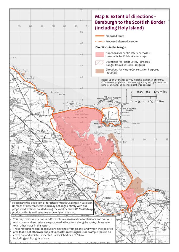
8. Restrictions and exclusions ................................................................................................................. 29
Map E: Extent of directions - Bamburgh to the Scottish Border (including Holy Island) ........................ 32
Annex A: Bibliography ................................................................................................................................ 33
Information about Natural England’s coastal access programme: ........................................................... 33
Information about the statutory framework for coastal access: ................................................................ 33
Environmental legislation referred to in the reports: ................................................................................. 33
Other published information used in the preparation of the report: .......................................................... 33
Annex B: Glossary of terms ........................................................................................................................ 35
Annex C: Excepted land categories ............................................................................................................ 40
Annex D: National restrictions ..................................................................................................................... 41
Countryside and Rights of Way Act 2000 .................................................................................................... 42
4 England Coast Path | Bamburgh to the Scottish Border (including Holy Island) | Overview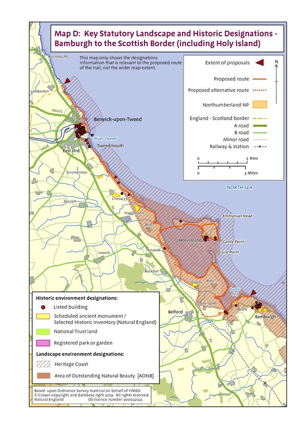
Please read first!
This Overview document sets out the context for Natural England’s proposals to improve public access to
and along the stretch of coast between Bamburgh and the Scottish Border (including Holy Island). It
explains key common principles and background underlying the detailed proposals that we make in our
compendium of linked but legally separate statutory reports, each covering a single length of coast within
the stretch. Each of these reports should be read in conjunction with this Overview.
Taken together, these reports explain how we propose to implement the England Coast Path (“the trail”) on
this stretch of coast, and detail the likely consequences in terms of the wider ‘Coastal Margin’ that will be
created if our proposals are approved by the Secretary of State. Our reports also set out:
any proposals we think are necessary for restricting or excluding coastal access rights to address
particular issues, in line with the powers in the legislation; and
any proposed powers for the trail to be capable of being relocated on particular sections (through
“roll-back”), if this proves necessary in the future because of coastal change.
So although this Overview has multiple reports associated with it, each report relating to a particular part of
the stretch makes free-standing proposals, and seeks approval for them by the Secretary of State in their
own right under section 52 of the National Parks and Access to the Countryside Act 1949.
We have carefully considered any potential environmental impacts of improving public access to this stretch
of coast, and made any necessary adjustments to our proposals prior to publication in order to address
these. Considerations in relation to environmental matters are explained in Section 6 of this Overview and
relevant reports for each length of coast. Links are provided to relevant separately published documentation
where appropriate.
The reports are published on our web pages as a series of separate documents, alongside this Overview
and more general information about how the Coastal Access programme works.
Each report is accompanied by detailed Proposals Maps for the relevant length of coast. The maps are
numbered according to the part of the report to which they relate. For example, maps BBS 1a to BBS 1k
illustrate the proposals in report BBS 1, which deals with the length from Bamburgh Castle Golf Course
Club House to Holy Island Causeway.
5 England Coast Path | Bamburgh to the Scottish Border (including Holy Island) | Overview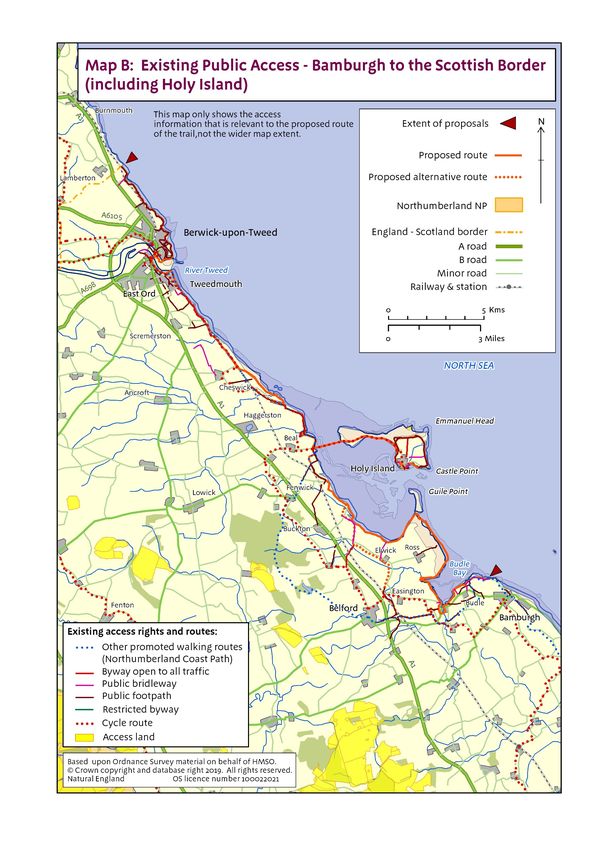
Introduction
1. Improving coastal access
Natural England has a statutory duty under the Marine and Coastal Access Act 2009 to improve access to
the English coast. The duty is in two parts: one relating to securing a long-distance walking route (“the trail”)
around the whole coast: we call this the England Coast Path; the other relating to a margin of coastal land
associated with the route which, in appropriate places, people will also be able to enjoy on foot. Associated
with this duty is a discretion given to Natural England to extend the trail up any river estuary on either or
both sides beyond the seaward limit of the estuarial waters 1, as far as the first bridge or tunnel with
pedestrian access, or as far as any point between the two.
To secure these objectives, we must submit statutory reports to the Secretary of State for Environment,
Food and Rural Affairs recommending where the route should be and identifying the associated coastal
margin. The reports must follow the approach set out in our methodology (the Coastal Access Scheme),
which – as the legislation requires – has been approved by the Secretary of State for this purpose.
This Overview and the related compendium of reports relate to the coast of Northumberland between
Bamburgh and the Scottish Border (including Holy Island). Taken together, our report proposals would
make the following key improvements to the existing arrangements for access to this part of the coast:
New sections of coastal path would be created in strategic places to link existing coastal paths into a
continuous route along this stretch of coast for the first time;
For the first time, there would be secure statutory rights of public access to most areas of beach, cliff
and other coastal land on this stretch of coast;
The coastal path would be able to ‘roll back’ as the cliffs erode or slip, or when other forms of
coastal change occur, solving long-standing difficulties with maintaining a continuous route on this
stretch of coast.
This is a significant opportunity to improve public access to this stretch of coast in these ways, with benefits
for residents, businesses and visitors. More people will have easier and more extensive access to the
coastal environment for open-air recreation, which is widely acknowledged to have significant benefits for
human health and well-being.
Once approved and established, this part of the England Coast Path will be managed as part of the family
of National Trails.
1
section 301 of the Marine and Coastal Access Act 2009
6 England Coast Path | Bamburgh to the Scottish Border (including Holy Island) | Overview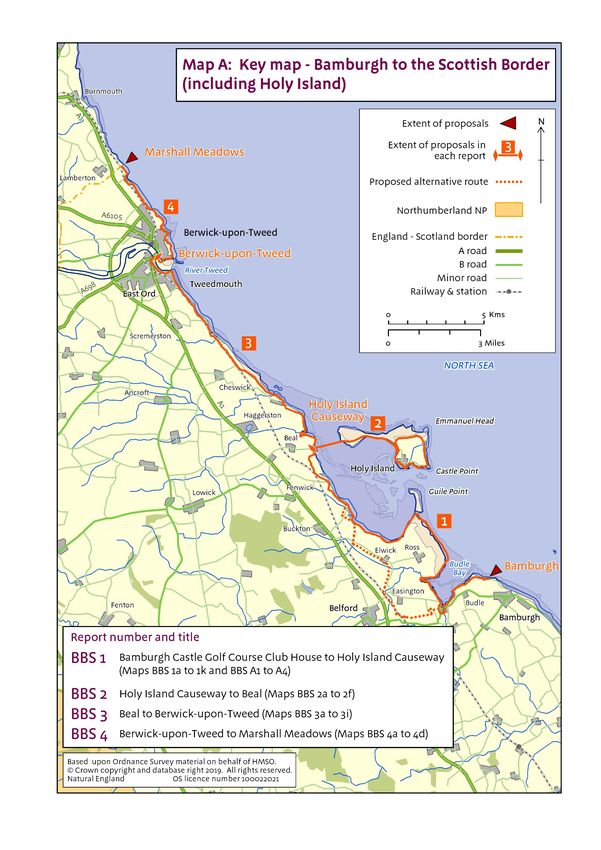
2. The determination process
Each of the reports for this stretch is submitted in accordance with our statutory duty under section 296 of
the Marine and Coastal Access Act 2009 (‘the 2009 Act’) to improve access to the English coast.
Publication of the reports has been advertised locally and online in accordance with the requirements of the
coastal access legislation.
Following publication:
Any person may make representations to Natural England about any of the reports; and
Any owner or occupier of affected land may make an objection to Natural England.
In order to be treated as valid, all objections and representations must be received by Natural
England no later than the end of the advertised eight week period following publication. The specific
closing date appears in the statutory notice for Bamburgh to the Scottish Border (including Holy
Island), which can be viewed here https://www.gov.uk/government/publications/enaglnd-coast-path-
from-bamburgh-to-the-scottish-border-including-holy-island-comment-on-proposals together with
more information about how to make representations or objections.
The Planning Inspectorate will consider any objections and any related representations before passing
recommendations to the Secretary of State, who in turn will consider both representations and objections
and then make a decision as to whether to approve our proposals. Chapter 3 of our Coastal Access
Scheme explains these processes in more detail (see Annex A: Bibliography).
The Secretary of State may confirm the proposals in each report in full, confirm some with modifications, or
reject some or all of them. If the conclusion is that some modification to our proposed approach is required,
further consideration may need to be given as to whether any further environmental assessment is
necessary. We may need to prepare an amended report for consideration by the Secretary of State, relating
to the part(s) of the coast affected by any rejected proposals. The same procedures for representation and
objection would apply to the amended report.
Once proposals for the stretch have been confirmed, there will be a preparation period before the new
access rights come into force. This period is to enable any necessary physical establishment of the trail to
be carried out and to put in place any necessary local management arrangements (including any approved
local access restrictions or exclusions).
Once the preparation period is complete, the rights will be brought into force by order on a date decided by
the Secretary of State. Normally one single commencement date is used for the whole stretch. We will
publicise the commencement of the rights to ensure they are known about and understood locally.
Parts 2 to 4 of each report explain more about the further steps that will be taken to establish the route,
provisions for its future maintenance and the procedures which we will follow to make any subsequent
changes that prove necessary once proposals for this part of the coast have been approved.
7 England Coast Path | Bamburgh to the Scottish Border (including Holy Island) | Overview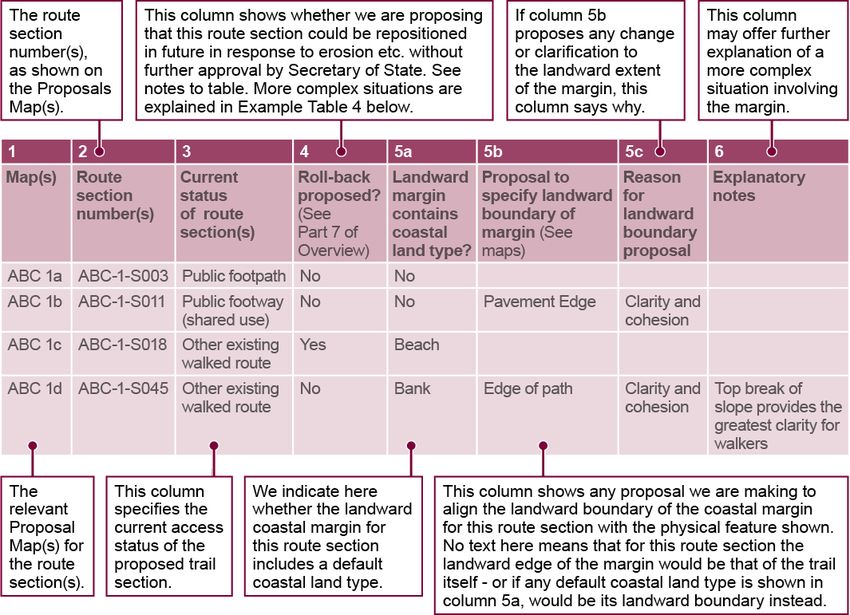
3. Understanding the proposals and accompanying maps
Before looking at the proposals and accompanying maps, it will help you if you read the following notes and
then look carefully at the key to the maps.
Our Proposals:
The proposals are divided into 4 reports, each relating to a particular length of coast on this stretch. Each
report is accompanied by detailed maps of the relevant length of coast. The maps are numbered according
to the report to which they relate. For example, maps BBS 1a to BBS 1k illustrate the proposals described
in report BBS 1.
Each report comprises four parts:
Part 1: Introduction – This sets the context for our proposals for that length of coast.
Part 2: Proposals Narrative - This summarises our alignment proposals in general, including any
proposed use of our discretions to align the route along an estuary, or recommended changes to the
default landward coastal margin. It also summarises the main access management measures that
will need to be introduced and the overall accessibility (ease of use for all) of this length of coast, for
all users. Additionally, it may identify any future changes of which we are aware that are likely to
impact on this part of the coast, and explain how our proposals deal with this change. In each report
the Part 2 Proposals Narrative, in conjunction with the Part 3 Proposals Tables and the Part 4
Proposals Maps, sets out our formal proposals to the Secretary of State in relation to the length of
coast in question, for which we are seeking approval under section 52 of the National Parks and
Access to the Countryside Act 1949.
Part 3: Proposals Tables – These line-by-line listings set out in more detail our formal proposals to
the Secretary of State for the length of coast in question, and should be read in conjunction with the
Proposals Narrative and the relevant Proposals Maps.
Part 4: Proposals Maps – These show in map form the proposals set out in the Proposals
Narrative and Proposals Tables.
Notes on how our Part 3 Proposals Tables work
These notes explain how the various tables found in each report work:
In the first table or set of tables, we set out detailed information for each section of coast under the
following column headings:
Map(s) – This column indicates which of the report maps to view alongside the details in the
other columns in the same row.
Route section number(s) – This is the unique identification number for the route section
concerned. In some cases, two or more adjacent route sections will be amalgamated into a
single row in the table, if all other displayed details happen to be identical.
Current status of route section(s) – This describes the current status of the route we have
proposed and whether it has any existing access rights. Public highways, including public rights
of way such as footpaths, are excepted from new coastal access rights because the existing
public rights to use such highways will remain in force, and the trail is able to make use of these.
Other sections of the proposed trail that do not currently have any access rights or where access
is currently permitted by the landowner will become subject to new coastal access rights if our
proposals are approved. These new rights, and any national or local restrictions on them, will not
affect any existing access arrangements for cyclists, horse-riders or other types of recreational
8 England Coast Path | Bamburgh to the Scottish Border (including Holy Island) | Overview
user that may currently exist at the local level - for example by formal agreement with, informal
permission from or traditional toleration by the owner of the land, or through any type of pre-
existing legal right that remains in force.
Roll-back proposed? – This indicates whether we propose that, in the event of significant
coastal erosion or other geomorphological processes or significant encroachment by the sea, a
section of trail which is affected by such factors should be capable of being repositioned in the
future in accordance with this formal proposal, without needing further confirmation of the
change at that time by the Secretary of State. Roll-back may be used to adjust the trail either in
direct response to such changes or in order to link with other parts of the route that need to roll
back in response to such changes. The column also indicates whether the ‘roll-back’
requirement is likely to give rise to a normal or more complex change on this section. (In the
case of more complex outcomes, further details are provided in the ‘Roll-back implementation’
table). Section 4.10 of the Coastal Access Scheme explains in more detail how roll-back works.
Landward margin contains default coastal land type? – Certain coastal land types are
automatically included in the coastal margin where they fall landward of the trail if they touch it at
some point. These coastal land types are: foreshore, cliff, bank, barrier, dune, beach, flat or
section 15 land. This column identifies where one of the coastal land types is present in the
landward coastal margin.
Proposal to specify landward boundary of margin – This sets out any proposals for the default
landward boundary of the coastal margin on this section to be altered or clarified - see iv below
in the Notes on Maps.
Reason for any proposed use of landward boundary discretion – This provides an explanation
for any such proposal to alter or clarify the default margin on this section. This may be either
because we are proposing a clear boundary around land that in our view would be margin by
default, because it matches the description of ‘coastal land’ explained at paragraph 4.8.8 of the
Scheme; or because we propose using our discretion to add land to or remove it from the default
margin, as described at paragraphs 4.8.11 of the Scheme.
Explanatory notes – This contains any additional information which may help further explain the
proposal for this route section or group of sections.
Where there is an alternative route or optional alternative route we set out the details of those routes
in a separate table. The table includes columns that describe the landward and seaward boundaries
of the alternative route strip. Alternative routes/optional alternative routes have a default width of two
metres either side of the approved line. We propose specific landward and/or seaward boundaries
to the route strip where doing so would add further clarity to the extent of access rights along the
route, by working with the grain of what is already there. It should be noted that where the
alternative route/optional alternative route follows an existing path corridor, the trail may adopt a
variable width as dictated by existing physical features.
Each report also includes a table that sets out any other options that were considered during our
initial planning (in relation to the route and the coastal margin), and explains why they did not form
part of our proposals.
The final table or set of tables for each report provides further details of any situation where local
circumstances mean that implementation of roll-back is likely to be more complex. We identify the
key issue and our expected resolution.
Annotated examples of these various tables are given below, to illustrate how they are used.
9 England Coast Path | Bamburgh to the Scottish Border (including Holy Island) | OverviewIn each report the Part 3 Proposals Tables, in conjunction with the Part 2 Proposals Narrative and the Part 4 Proposals Maps, set out our formal proposals to the Secretary of State in relation to the length of coast in question, for which we are seeking approval under section 52 of the National Parks and Access to the Countryside Act 1949. 10 England Coast Path | Bamburgh to the Scottish Border (including Holy Island) | Overview
Examples of tables found in each report, with explanation of their contents:
Example table 1: Section details

Example table 2: Alternative routes and optional alternative route details

11   England Coast Path | Bamburgh to the Scottish Border (including Holy Island) | Overview
Example table 3: Other options considered

Example table 4: Roll-back implementation – more complex situations

12   England Coast Path | Bamburgh to the Scottish Border (including Holy Island) | Overview
Notes on how our Part 4 Proposals Maps work
The notes that follow will help explain the maps provided for each report.
The proposed route of the trail:
i The thickness of the line used to depict the proposed route on the maps is intended to make it easy
to find on the map and to enable us to differentiate, by shading the line differently, between sections
of the route that would use existing rights of way, sections that appear to follow other existing
walked lines on the ground, and sections that do neither. The thickness of the line on the map is not
an indication of the width of the actual trail on the ground – the proposed route simply follows the
centre of the line shown. The legislation makes the default width of the trail four metres, but its
actual width varies a good deal in practice according to the detail included section by section in our
proposals.
ii In places there are differences between the line of public rights of way recorded on the local
Definitive Map that is maintained by the local highway authority, and paths currently used and
managed on the ground as public rights of way. Some of these differences may be attributed to
adaptation of the path over time to cope with coastal erosion and other processes, whilst others
appear to arise from anomalies in the way the rights were originally recorded on the definitive map.
The maps in this report show the public rights of way as recorded on the definitive map, and depict
them as accurately as possible at the scale used. See part 4.7 of the Scheme for further information.
The coastal margin:
iii The proposed route of the trail shown on the maps is important in understanding the extent of the
coastal margin that would apply to either side of it. Under the legislation:
the coastal margin is a single, continuous corridor of land which includes the trail itself;
the margin includes all land seaward of the trail land - although not all of that land would be
subject to a new right of access (see point vi below);
the landward extent of this margin is by default the trail itself, or the inland edge of any land
adjoining the trail on its landward side that is foreshore, cliff, dune or beach, or a bank, barrier or
flat, or section 15 land (see Annex B: Glossary of terms).
iv We have the discretion to propose that the landward boundary of the coastal margin should coincide
with a recognisable physical feature on the ground – even if the effect of doing so is to add land into
the margin, or to remove land from it. We may use this discretion:
to propose that instead of the default trail width of four metres set by the legislation, particular
physical features such as walls, fences or pavement edges should be used where appropriate to
define the landward extent of the trail land on that section of the route: such features cannot be
depicted on the maps at the scale used, but they are described in the Proposals Tables;
to clarify or adjust the boundaries of a landward area included by default as margin, in order to
create a better ‘fit’ with the circumstances on the ground; or
to propose in some places that additional areas of land should be added to the coastal margin
landward of the trail: land which is affected by such proposals is indicated on the maps with a
purple wash and described in parts 2&3 of each report.
Further explanation of these powers can be found at part 4.8 of the Coastal Access Scheme. Our
proposals take full account of any views expressed by the owner or occupier of affected land about
whether the powers should be used in any of these ways.
v Land which forms part of the coastal margin would be subject to access rights, other than:
13 England Coast Path | Bamburgh to the Scottish Border (including Holy Island) | Overview any excepted land, such as land covered by buildings or their gardens or curtilage: Annex C
summarises in full the categories of excepted land under the legislation; or
any land where coastal access rights would be excluded under our statutory powers: we
indicate in the report where we already know of circumstances that make this necessary, and
make any proposals accordingly.
vi Spreading room is the term used in the reports to describe any land, other than trail land, which
would form part of the coastal margin and would have public rights of access. It does not therefore
include any excepted land within the margin, or any existing access land on the landward side of the
trail that is omitted from the margin.
Annex B (Glossary of terms) includes a full definition of these terms which you may find helpful in
understanding the report.
Voluntary access dedication
vii Land that was previously dedicated as access land under section 16 of the Countryside and Rights
of Way Act 2000 (CROW) will become subject to the coastal access regime if it forms part of the
coastal margin in any of the ways described above. There is also provision in the legislation for a
land owner or long leaseholder to dedicate other land voluntarily as coastal margin if it lies adjacent
to it or within it. Dedicating land as coastal margin disapplies the excepted land provisions within it,
and may also make provision for the removal or relaxation of specific national restrictions that
would otherwise apply. Parts 4.8.20 to 4.8.23 of the Coastal Access Scheme explain these
provisions in more detail.
In each report the Part 4 Proposals Maps, in conjunctions with the Part 2 Proposals Narrative and the Part
3 Proposals Tables, set out our formal proposals to the Secretary of State in relation to the length of coast
in question, for which we are seeking approval under section 52 of the National Parks and Access to the
Countryside Act 1949.
14 England Coast Path | Bamburgh to the Scottish Border (including Holy Island) | Overview4. Preparation of the report
To secure the twin objectives under the legislation we have followed the approach set out in our Coastal
Access Scheme, as approved by the Secretary of State on 9 July 2013. Chapter 3 of this detailed document
sets out the stages of implementation we must follow.
In line with this, before making the proposals in this compendium of reports for the stretch, we conducted
extensive preliminary work in two main stages:
Stage 1: Prepare – defining the extent of the coastal stretch with access authorities and identifying
the key issues and opportunities, including sensitive features, in conjunction with key organisations;
and
Stage 2: Develop – checking the alignment on the ground, sharing our initial thoughts with land
owners and offering to ‘walk the course’ with them, planning for the protection of key features,
talking further with key interests and reality checking our proposals.
Stage 1 - Prepare
This stage involved us working closely with access authorities to develop an understanding of the stretch,
agree its exact extent and carry out initial familiarisation visits. We held discussions with representatives of
national and local organisations with a strategic interest in this stretch of coast. This included discussions
with those we are required by legislation to consult at this stage:
the Local Access Forum;
Northumberland County Council officers, including ecology, transport and Rights of Way team staff;
officers of Northumberland Coast Area of Outstanding Natural Beauty;
local officers from the Environment Agency, in relation to flood defence and coastal erosion
management on this stretch of coast;
local officers of Historic England, in relation to historic features on this stretch of coast; and
We also held discussions with representatives of specific interest groups, including:
the Ramblers;
the British Horse Society;
Sustrans;
Northumberland Wildlife Trust;
the National Trust;
the National Farmers Union;
the British Association for Shooting and Conservation;
the Country Land and Business Association, and
the Lindisfarne National Nature Reserve Joint Advisory Committee.
We publicised on our website the start of work on the stretch and provided an opportunity for all other
interested parties to submit to us their views on local issues and opportunities.
We also engaged with internal specialists and relevant organisations locally - including Royal Society for
the Protection of Birds, English Heritage - to consider any potential for impacts on key sensitive features.
15 England Coast Path | Bamburgh to the Scottish Border (including Holy Island) | OverviewIn addition to these discussions we took into account a wide variety of information, plans and strategies that we considered relevant to the alignment process. Those that are published on the internet are listed in Annex A: Bibliography. We then took all reasonable steps to identify owners, occupiers and those with a legal interest in the land which could be affected. Stage 2 - Develop This stage involved us contacting, and discussing our initial thoughts with, relevant owners, occupiers and other legal interests. We asked for their views and invited them to join us when we visited the land to ‘walk the course’ so that we could discuss options for alignment based on mapped summaries of our emerging proposals. In most cases this was done through separate site meetings with the individuals and businesses concerned. We also took reasonable steps to identify and contact any owners, occupiers or other legal interests who could foreseeably be affected in the future as a result of any roll-back that may prove necessary). See part 7 – Future Changes – below. We then held further detailed discussions with internal and external specialists to refine our thinking on protecting key sensitive features, carrying out any necessary assessments. After further discussions with key local and national organisations we refined our proposals and checked them on the ground before moving onto Stage 3 – Propose, which is the substance of these reports. 16 England Coast Path | Bamburgh to the Scottish Border (including Holy Island) | Overview
Key issues along this stretch
5. Discretion to include part or all of an estuary or estuaries
The Bamburgh to the Scottish Border (including Holy Island) stretch includes part of the estuary of the River
Tweed.
a) Introduction
This part of the Overview:
introduces the core statutory duties and considerations for the national programme as a whole in
relation to exercising the discretion to include part, or all, of an estuary within our proposals;
describes the overall nature of the estuary system(s) found in this part of England, identifying the
geographical limits of our discretion to align the trail around the River Tweed estuary included within
this stretch of coast;
goes on to explain in more detail how each of the specific estuary considerations set out at section
301 of the 2009 Act affects our view of the options for the River Tweed estuary;
sets out the options for estuary trail alignment which we have identified as a result of this analysis,
and;
describes and explains our chosen proposal.
b) Estuary discretion
Under the 2009 Act there is no requirement for the trail to extend up any estuary further than the seaward
limit of estuarial waters that is explained below under “Geographical limits of our discretion”.
But Natural England has a discretion to propose that the trail should extend from the seaward limit as far as
the first bridge over which, or tunnel through which, there is a public right of way, or a public right of access,
by virtue of which the public are able to cross the river on foot, or as far as any specified point in between.
In exercising its discretion, Natural England must have regard to the core national duties and considerations
described in Part B and Chapter 10 of the Coastal Access Scheme.
c) Core national duties and considerations relevant to estuaries
Section 296 of the 2009 Act places a legal duty (the Coastal Access Duty) on Natural England and the
Secretary of State to secure a walking route around the whole of the open coast of England, together with
an associated margin of land for the public to enjoy either in conjunction with their use of the route, or
otherwise.
Section 297 goes on to require both, in discharging this duty, to have regard among other things to the
desirability of ensuring that so far as reasonably practicable, interruptions to this route are kept to a
minimum. This is a key consideration for the whole of the national delivery programme for coastal access.
The whole concept of the England Coast Path relies on delivering continuity of the route so far as
reasonably practicable for the whole country. Although proposing a route around each estuary is a
discretion rather than a legal duty, if the presence of an estuary would interrupt this continuity of access
along the open coast then this will constitute a strong prima facie reason for the trail to serve the estuary
too, at least to the extent necessary to enable users to continue their onward journey around the coast.
The Scheme notes at paragraph 10.1.4 that because the seaward limit of estuarial waters is an arbitrary
point from an access perspective, we are likely to use our discretion at most estuaries to extend the trail
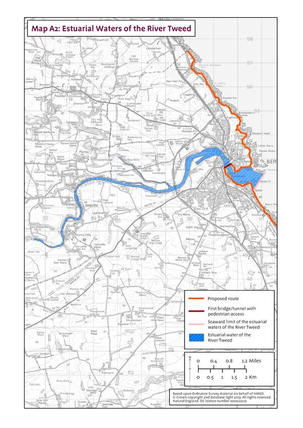
17 England Coast Path | Bamburgh to the Scottish Border (including Holy Island) | Overviewupstream to a more convenient point than this seaward limit. Paragraph 10.1.5 then adds “We will always give careful consideration to our option to extend the trail as far as the first bridge or tunnel with pedestrian public access” – both for reasons of continuity, and with a view to any additional recreational benefits that might result within the estuary itself from doing so. Chapter 10 of the Scheme explains the statutory estuary criteria that section 301(4) of the 2009 Act requires to be taken into account in deciding whether or not to include an estuary in our proposals. These are discussed in more detail in subsection e) below in relation to the River Tweed estuary. The other key considerations, including achieving a fair balance with the interests of owners and occupiers, are discussed in part 6 of this Overview. d) Overall nature of estuary systems in this part of England The lower reaches of the River Tweed meanders through the north Northumberland countryside, close to the Scottish Border, from west to east. The Tweed estuary is bound to the both its northern and southern sides by the town of Berwick-upon-Tweed. Berwick-upon-Tweed is a busy town with good transport links, it being just off the A1 and having a main line train station. It attracts a large number of visitors and holidaymakers throughout the year for recreation, including sight-seeing, walking, fishing and water sports. The town has a working port which operates from the southern bank of the estuary. e) River Tweed estuary Geographical limits of our discretion Map A2 shows the Tweed estuary between its seaward limit and Berwick Bridge which we propose as the most suitable crossing point of the estuary. Berwick Bridge is the first pedestrian crossing point. It provides a safe and convenient way of crossing the estuary and is part of the Northumberland Coast path route. The statutory estuary criteria We have considered below each of the section 301 criteria under the headings given in Chapter 10 of the Scheme. i) Ferry services There is no ferry service crossing the estuary. ii) Character of the Estuary Estuary width The estuary is a largely constant width of roughly 130 metres between Berwick Bridge and its seaward limit. Topography of the shoreline The land immediately inland from the estuary is low lying and mostly flat, but the gradient increases quite steeply as you move inland. Nature of affected land To the south the area mostly comprises of residential and commercial properties. These surround the old port and dock areas where some new residential development is planned. 18 England Coast Path | Bamburgh to the Scottish Border (including Holy Island) | Overview
To the north the shoreline is partly bounded by the historic city ramparts. Beyond which is a mix of well-
established residential and commercial properties which make up the town of Berwick-upon-Tweed.
Features of interest
The historic buildings and infrastructure of Berwick-upon-Tweed combined with the views of the estuary,
coast and surrounding countryside make for a wonderfully diverse landscape.
iii) Recreational Benefit
Both the northern and southern banks of the estuary benefit from extensive networks of existing access
which are widely used by locals and visitors alike.
iv) Excepted land
On the southern bank of the estuary there are quite large areas of excepted land between the proposed trail
and mean low water. These are mostly represented by the operational areas of the dock/port.
The northern side has a number of distinct areas of excepted land that are considered to be buildings and
their curtilage.
v) Options for the Tweed estuary
Option 1 – End the trail from the south at Spittal and from the north at Berwick-upon-Tweed. This
would create a gap of 0.7km (across the seaward limit of the estuary) in the England Coast Path, in
a well populated area, directly around the town of Berwick-upon-Tweed.
Option 2 – Align the trail along a series of existing walked routes to create a continuous walking
route along the southern and northern sides of the estuary, via Berwick Bridge.
Proposed route of the trail
We propose to pursue option 2. In our view this option strikes the right balance and offers the greatest
scope for improvement to public access on this part of the coast by:
creating a continuous way-marked route between Spittal and Berwick-upon-Tweed;
upgrading existing access infrastructure where necessary along the proposed route.
19 England Coast Path | Bamburgh to the Scottish Border (including Holy Island) | OverviewMap A2: Estuarial Waters of the River Tweed Insert Map A2 showing estuarial limit(s) (one map showing all estuaries on the stretch) 20 England Coast Path | Bamburgh to the Scottish Border (including Holy Island) | Overview
6. Other considerations on this stretch

a) Recreational Issues

We have considered interrelationships between our proposals and the Northumberland Rights of Way
Improvement Plan. Our proposals will supplement the ambitions described in this plan by enhancing
provision of access at the coast

Map B gives an overview of existing public access to the Northumberland coast between Bamburgh and the
Scottish Border (including Marshall Meadows) showing public rights of way, access land and promoted
routes along the stretch.

The southern end of the stretch benefits from existing public rights of way along the coast from Bamburgh
up to Budle. This path maintains excellent coastal views for the most part and is well used by locals and
visitors alike.

Holy Island is well served by public rights of way and these afford good coastal views in parts and where
they depart from the shore they do still maintain coastal feel. The island is a place of significant historic and
landscape interest, which is why we have chosen to align the trail onto and around it.

From the middle of the stretch, all the way to its northern end point, there is a mixture of public rights of way
that give outstanding coastal views and strong coastal aspect. For the most part, we have proposed that
the route coincides with them.

b) Protection of the environment

The coast and coastal fringe are of national and international nature conservation importance for their
geology, dune and coastal cliff habitats, offshore islands and intertidal habitats which support internationally
significant populations of birds, grey seals and scarce plants. The coastline is therefore covered by a
number of designations: Sites of Special Scientific Interest, Special Areas of Conservation, and Special
Protection Areas and Ramsar sites. The National Nature Reserve at Lindisfarne protects a significant
(3,541 hectares) stretch of the mainland coast and Holy Island Dunes. The coastline is a recognised
Heritage Coast and designated as an Area of Outstanding Natural Beauty.

The Coast along the mainland of this stretch has two significant and popular access points at Bamburgh
and Berwick, at these points there is extensive use of the coast and associated sandy beaches. Elsewhere
on the mainland access to the coast is limited and less well known to visiting tourists. Sandy beaches at
Ross Back Sands, Goswick Sands, Cheswick Sands and Cocklawburn beach are less well known or used.
However local and national promotions are changing this pattern. Holy Island dominates the coastline as
the destination for tourists accessed by the causeway at low tide only. The AONB invests much time and
resource such as their ‘Coast care’ volunteer team into sensitive recreational management and visitor
engagement. The Northumberland Coast Path and National Cycle Route 1 ‘Coast & Castles’ are both very
popular and have already been developed with the sensitive features in mind.

As a result of the proposals described in this Overview and associated reports for each length of coast, the
quality of coastal paths will be improved and there will be greater certainty and clarity about the rights
people have within the coastal margin. Use of the coast for outdoor recreation can, if not carefully
managed, add to environmental pressures such as the presence of people causing disturbance to wildlife or
new paths leading to removal and fragmentation of habitat. Part of the process we go through on each
length of coast when we are developing our detailed proposals is about finding ways to avoid or reduce
such impacts, and ensure compliance with legislation to protect the environment.

21   England Coast Path | Bamburgh to the Scottish Border (including Holy Island) | Overview
In developing our detailed proposals for coastal access we have taken account of environmental protection
objectives and these are, where relevant, discussed in more detail in the relevant report for each length of
coast and the following documents that we have published separately:
A single Habitats Regulations Assessment (https://www.gov.uk/government/publications/enaglnd-
coast-path-from-bamburgh-to-the-scottish-border-including-holy-island-comment-on-proposals)
relating to any potential impact on the conservation objectives of affected sites from the proposals
we make in each report for the stretch. This assessment considers any potential impacts in relation
both to the individual length of coast covered by each report, and to the stretch as a whole.
Our Nature Conservation Assessment (https://www.gov.uk/government/publications/enaglnd-coast-
path-from-bamburgh-to-the-scottish-border-including-holy-island-comment-on-proposals) for the
stretch, in which we document our conclusions in relation to any other potential impacts on nature
conservation.
c) Interests of owners and occupiers
In discharging our coastal access duty we must aim to strike a fair balance between the interests of the
public in having rights of access over coastal land, and the interests of owners and occupiers of land over
which any coastal access rights would apply. This was a key driver in the design of our proposals, which
were discussed in detail with the owners and occupiers of the affected land during ‘walking the course’ and
other processes.
Rural coast
The majority of this stretch of coast is rural in nature and consists of mixed farmland. Tourism is a major
contributor to the economy of the area, with the Northumberland Coast Path being a well-established and
attractive walk. In general, landowners are accepting of the promoted route and understand the benefits
that it brings to the area. Indeed, many landowners have diversified their business to cater for visitors to the
area by providing accommodation.
The majority of feedback we have received from landowners and occupiers has expressed a desire for the
England Coast Path to mainly adopt the route of the existing Northumberland Coast Path, where this is
possible. Although in places we have adopted a more seaward alignment in order to adhere to the
periphery of the coast and provide views of the sea.
Urban coast
The only town on the open coast of the stretch is Berwick-upon-Tweed. The town benefits from tourism,
with day trippers using the good train links and others who want a longer stay making use of the wide
variety of holiday accommodation that is available locally.
The proposed route through the town makes use of existing access which hugs the coast line and River
Tweed estuary.
No major issues were raised by owners and occupiers in the early stages of the planning for this stretch.
Industrial coast
To the south of Berwick-upon-Tweed there is an industrial area and this is dominated by the port. The
route through this area mostly follows existing public access (see map B: Existing public access on the
Bamburgh to the Scottish Border (including Holy Island) stretch).
No significant issues were raised by landowners or occupiers regarding this route, which is mainly aligned
along footways by public highways and public footpaths. Some initial concerns were raised about public
access to industrial areas, but we explained that such areas would fall into the ‘excepted land’ category, so
whilst they are within the access margin they would not form part of the available ‘spreading room’.
22 England Coast Path | Bamburgh to the Scottish Border (including Holy Island) | Overviewd) Coastal processes
The principal source of information regarding coastal processes on this stretch of coast is the Scottish
Border to the River Tyne Shoreline Management Plan (see Annex A: Bibliography), a non-statutory policy
document for the management of flood risk and coastal erosion. With reference to this document, and with
advice from the Environment Agency and officers from Northumberland County Council, we have identified
the parts of the coast within this stretch which are particularly susceptible to coastal erosion or other
geomorphological processes, such as landslips.
In general where the coast is defended with some certainty, we have not made any specific proposals to
enable the trail to adapt to coastal change - for example, where the trail would be:
on, or on the landward side of sea defences which would protect it; or
landward of the roads and railway which would be protected under the policies set out in the
Shoreline Management Plan 2.
However, in some cases we have identified a possible requirement for roll-back even in scenarios like this,
to ensure that we can maintain continuity of the trail should a nearby section of the trail be affected by
coastal change (see Part 4.10 of the approved Scheme).
The developed areas of Berwick-upon-Tweed described in BBS 3 and 4 of the proposals are defended by
sea defence structures and are unlikely to be affected significantly by coastal processes in the foreseeable
future. We have not made any specific proposals to enable the trail to adapt to coastal change on these
lengths of coast.
The eroding cliffs along the open, rural coast described in BBS 1 to 4 of the proposals are largely
undefended and subject to varying rates of change. On these lengths of coast we propose to recommend
that the trail is able to roll back so that it can be repositioned without further reference to the Secretary of
State, once he has approved the initial route. There is more detail about these roll-back arrangements in
part 7 of the Overview and in the relevant chapters of the proposals.
23 England Coast Path | Bamburgh to the Scottish Border (including Holy Island) | OverviewMap B: Existing Public Access - Bamburgh to the Scottish Border (including Holy Island) (Insert Map B: Existing public access on Bamburgh to the Scottish Border (including Holy Island) 24 England Coast Path | Bamburgh to the Scottish Border (including Holy Island) | Overview
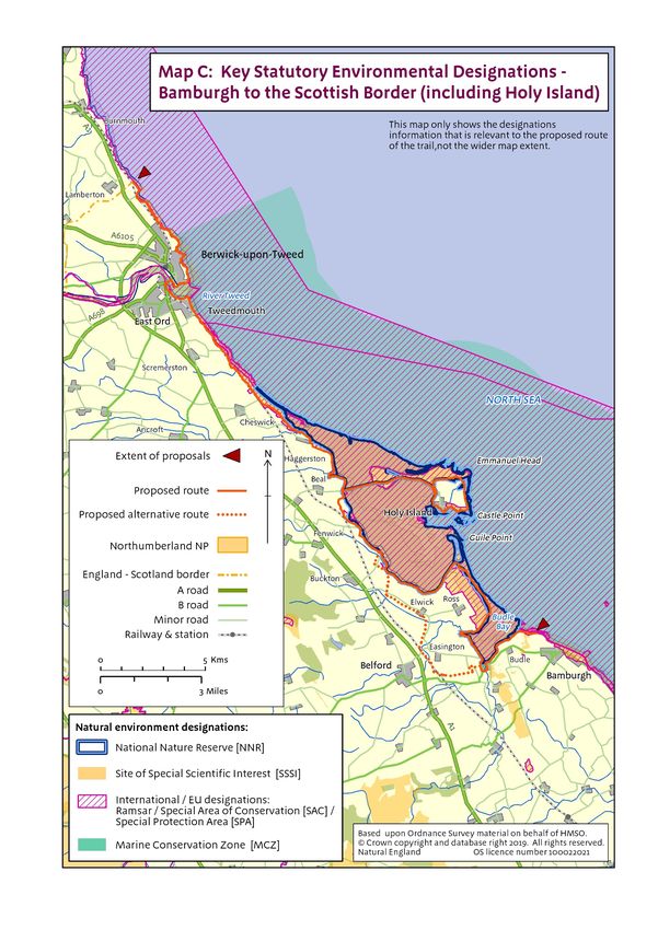
Map C: Key Statutory Environmental Designations - Bamburgh to the Scottish Border
(including Holy Island)

(Insert Map C: Key statutory environmental designations on Bamburgh to the Scottish
Border (including Holy Island)

25   England Coast Path | Bamburgh to the Scottish Border (including Holy Island) | Overview
Map D: Key Statutory Landscape and Historic Designations - Bamburgh to the Scottish
Border (including Holy Island)

(Insert Map C: Key statutory environmental designations on Bamburgh to the Scottish
Border (including Holy Island)

26   England Coast Path | Bamburgh to the Scottish Border (including Holy Island) | Overview
Other issues
7. Future changes
Below we explain the procedures for future changes to the coastal access provisions, once proposals have
been approved by the Secretary of State. Where the need for future changes was foreseeable at the time of
preparing the proposals we have indicated this in the relevant report(s).
Roll-back
Reports BBS 1 to BBS 4 include proposals for specified parts of the route to ‘roll back’ either:
in direct response to coastal erosion or other geomorphological processes, or significant
encroachment by the sea; or
in order to link with other parts of the route that need to roll back as a direct result of coastal erosion
or other geomorphological processes, or significant encroachment by the sea.
Where sections of the approved route need to change for these reasons in order to remain viable, the new
route will be determined by Natural England without any requirement for further reference to the Secretary
of State. Coastal erosion can happen at any time and so, in some cases, this provision may need to be
invoked between approval of the report and commencement of new access rights.
In particular, so far as we consider it necessary in order to maintain the viability of the route as a whole, we
may determine that any part of the route is to be repositioned landward of any physical boundary feature,
area of excepted land or area from which we consider it necessary to exclude access e.g. a protected site
designated for its conservation value.
In determining the new route, we will take into account:
the local factors present at that time, including any views expressed by people with a relevant
interest in affected land;
the terms of the Coastal Access duty (see Annex B: Glossary of terms), including the requirement to
aim to strike a fair balance between the interests of the public and the interests of any person with a
relevant interest in the land; and
the criteria set out in part B of the Coastal Access Scheme.
Any changes to the route in accordance with these proposals will come into force on a date decided by us.
On this date, coastal access rights will come into force as necessary along any new alignment. The date of
change will follow any necessary physical establishment work, including any installation of signs to enable
the public to identify the modified route on the ground. We will take reasonable steps to ensure that anyone
with a relevant interest in land directly affected by the change is made aware this date.
In places where the trail rolls back in this way in response to coastal change, the landward extent of the
coastal margin may also move inland automatically:
with the trail itself, or
because a landward area of section 15 land (see Annex B: Glossary of terms) or foreshore, cliff,
dune, or beach, or a bank, barrier or flat, newly touches the trail when it rolls back, with the result
that it automatically becomes part of the margin under the terms of the legislation.
Ordinarily, where roll-back has been proposed and becomes necessary, we would expect the trail to be
adjusted to follow the current feature (for example, the cliff edge or top of foreshore). Where we foresee that
local circumstances will require more detailed consideration, we have provided further information within the
tables in Part 3 of the relevant report. This and the above information is intended as a guide only, based on
information available to us at the time of writing, and on expert advice provided by the access authority,
27 England Coast Path | Bamburgh to the Scottish Border (including Holy Island) | OverviewEnvironment Agency and others. We have taken and will continue to take all reasonable steps to discuss
implications and options with all parties likely to affected by such changes, both during the initial planning
work that preceded the writing of the reports for each length, and during any future work to plan and
implement a ‘rolled back’ route.
Other changes
We will normally be required to submit a variation report seeking approval from the Secretary of State in
order to make any other changes to the route of the trail (or to propose non-automatic changes to the
landward boundary of the coastal margin) - for example if the land was subject to new build development.
Such changes would be subject to the same procedures for consultation, representations and objections as
our initial reports. Potential developments of which we are already aware that could potentially affect the
route on the stretch are summarised below.
However, even without a variation report:
i We would be able to impose new or modify existing local restrictions or exclusions on coastal
access rights as necessary, and people with a legal interest in the land would be able to apply to us
for such directions under certain circumstances – see chapter 6 of the Coastal Access Scheme.
ii Further work could be carried out where necessary either to establish or maintain the route, or to
provide any means of access to the coastal margin, using powers and procedures set out in
Schedule 20 of the Marine and Coastal Access Act 2009 and chapter 3 of Part 1 the Countryside
and Rights of Way Act 2000.
iii. If at any time the use of affected land should change, the normal rules in relation to excepted land
would apply, so for example land newly covered by buildings and their curtilage, and land in the
course of development, would automatically become excepted from the coastal access rights – see
Annex C: Excepted Land Categories.
28 England Coast Path | Bamburgh to the Scottish Border (including Holy Island) | OverviewYou can also read