European Red List of Habitats - Terrestrial and freshwater habitats - European Commission
←
→
Page content transcription
If your browser does not render page correctly, please read the page content below
European
              Red List of
              Habitats

              Part 2.
              Terrestrial and
              freshwater habitats

Environment
More information on the European Union is available on the internet (http://europa.eu).
Luxembourg: Publications Office of the European Union, 2016

ISBN 978-92-79-61588-7
doi: 10.2779/091372

© European Union, 2016
Reproduction is authorised provided the source is acknowledged. The photos are copyrighted and cannot be used without prior approval from the photographers.

Printed in England
Printed on recycled paper that has been awarded the EU eco-label for graphic paper (http://ec.europa.eu/environment/ecolabel/)

Cover: Active volcano, Iceland. © Wim Ozinga. Insets: Freshwater lake, Finland. © Heikki Toivonen. Larix forest, Mercantour, France. © Benoît Renaux. Soft coastal cliff, Latvia. © John Janssen.
Machair grassland, Ireland. © Joop Schaminée. Calcareous quaking mire, Finland. © Teemu Tahvanainen. Spring mire, Dolomites, Italy. © Michal Hájek.
European Red List of Habitats
     Part 2. Terrestrial and freshwater habitats

                                                                    Authors

     J.A.M. Janssen, J.S. Rodwell, M. García Criado, S. Gubbay, T. Haynes, A. Nieto, N. Sanders, F. Landucci, J. Loidi, A. Ssymank,
 T. Tahvanainen, M. Valderrabano, A. Acosta, M. Aronsson, G. Arts, F. Attorre, E. Bergmeier, R.-J. Bijlsma, F. Bioret, C. Biţă-Nicolae,
  I. Biurrun, M. Calix, J. Capelo, A. Čarni, M. Chytrý, J. Dengler, P. Dimopoulos, F. Essl, H. Gardfjell, D. Gigante, G. Giusso del Galdo,
   M. Hájek, F. Jansen, J. Jansen, J. Kapfer, A. Mickolajczak, J.A. Molina, Z. Molnár, D. Paternoster, A. Piernik, B. Poulin, B. Renaux,
                  J.H.J. Schaminée, K. Šumberová, H. Toivonen, T. Tonteri, I. Tsiripidis, R. Tzonev and M. Valachovič

                                                           With contributions from

     P.A. Aarrestad, E. Agrillo, E. Alegro, I. Alonso, S. Angus, O. Argagnon, S. Armiraglio, S. Assini, L. Aunina, A.B.G. Averis, A.M. Averis,
         S. Bagella, Z. Barina, S. Barron, S. Bell, E. Bendiksen, J. Bölöni, T.E. Brandrud, J. Brophy, G. Buffa, J.A. Campos, L. Casella,
 C. Christodoulou, A. Church, P. Corbett, J.-M. Couvreur, J. Creer, A. Crowle, J. Dahlgren, L. De Keersmaeker, R. Delarze, L.-M. Delescaille,
        L. Denys, S. De Saeger, F. Devany, D. de Vries, I. Diack, M. Dimitrov, W. Eide, D. Espirito Santo, M. Fagaras, V. Fievet, P. Finck,
   U. Fitzpatrick, G. Fotiadis, E. Framstad, P. Frankard, C. Giancola, Ch. Gussev, R. Hall, B. Hamill, R. Haveman, S. Heinze, S. Hennekens,
    C. Hobohm, P. Ivanov, A. Jacobson, G. Janauer, M. Janišová, R.G. Jefferson, P. Jones, N. Juvan, Z. Kącki, A. Kallimanis, Y. Kazoglou,
    D. Keith, K. Keulen, G. Király, K. Kirby, M. Kočí, T. Kontula, E. Leibak, A. Leyssen, S. Lotman, A. Lyngstad, H. Mäemets, C. Mainstone,
K. Mäkelä, C. Marceno, J.R. Martin, V. Matevski, A. Mesterházy, Đ. Milanović, F. Millaku, R. Miller, J. Millet, M. Mjelde, A. Moen, B. Nygaard,
      D.-I. Øien, F. O’Neill, J. Paal, J. Packet, D. Paelinckx, C. Panaïotis, M. Panitsa, P. Perrin, G. Pezzi, I. Prisco, M. Prosser, S. Provoost,
   V. Rašomavičius, U. Raths, S. Rees, U. Riecken, E. Roosaluste, I. Rove, J. Reymann, J.P. Rodriguez, E. Rothero, V. Rusakova, S. Rusina,
   C. Scanlan, R. Schuiling, S. Sciandrello, I. Sell, J. Šibík, J. Simkin, Ž. Škvorc, D. Spray, D. Stešević, G.H. Strand, V. Stupar, A. Thomaes,
       S. Trajanovska, A. Van Braekel, W. Van Landuyt, K. Vanderkerkhove, B. Vandevoorde, J. Van Uytvanck, A. Varga, N. Velkovski,
           R. Venanzoni, P. Verté, D. Viciani, M. Vrahnakis, E. Von Wachenfeldt, H. Wallace, S. Watt, E. Weeda, L. Wibail, W. Willner,
                                                               P. Wilson and F. Xystrakis

                                                                                                                                         John Rodwell
                                                                                                                                         Ecologist
                                                                                                                Susan Gubbay
2 European Red List of Habitats
Contents
Foreword........................................................................................................................................................................................................1
Abstract..........................................................................................................................................................................................................1
Executive Summary...............................................................................................................................................................................2
1. Introduction............................................................................................................................................................................................3
1.1 Background......................................................................................................................................................................................3
1.2 Aims and scope of the assessment..................................................................................................................................3
2. Methodology..........................................................................................................................................................................................4
2.1 The work flow..................................................................................................................................................................................4
2.2 Habitat typology...........................................................................................................................................................................4
2.3 Categories and Criteria.............................................................................................................................................................4
2.4 Data sources...................................................................................................................................................................................5
3. Results.......................................................................................................................................................................................................7
3.1 General overview..........................................................................................................................................................................7
3.2 Coastal habitats...........................................................................................................................................................................9
3.3 Freshwater habitats................................................................................................................................................................11
3.4 Mires and bogs...........................................................................................................................................................................13
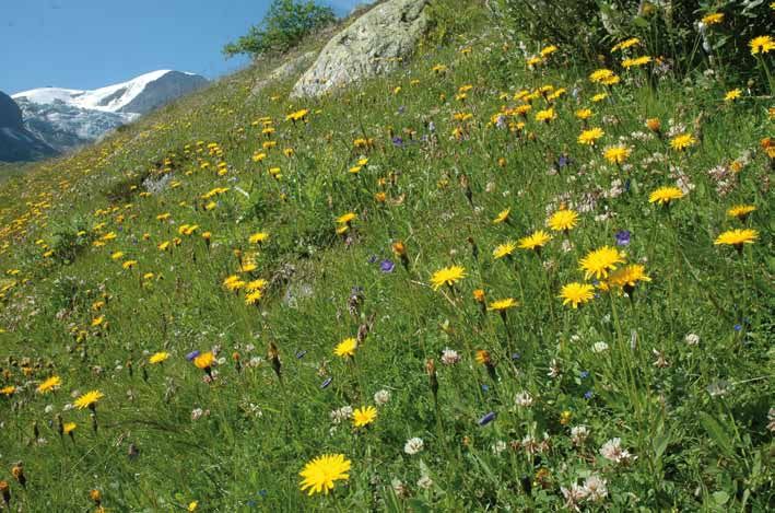
3.5 Grasslands....................................................................................................................................................................................15
3.6 Heathland and scrub...............................................................................................................................................................17
3.7 Forests.............................................................................................................................................................................................19
3.8 Sparsely vegetated habitats..............................................................................................................................................22
4. Discussion.............................................................................................................................................................................................24
4.1 The geographic scope of the assessment.................................................................................................................24
4.2 The habitat typology...............................................................................................................................................................24
4.3 Gaps and uncertainties in the data...............................................................................................................................24
4.4 Assessment criteria.................................................................................................................................................................25
4.5 Other unassessed characteristics and values .......................................................................................................26
5. Applications of the Red List.....................................................................................................................................................27
5.1 General policy applications.................................................................................................................................................27
5.2 The mapping of ecosystems and their services.....................................................................................................27
5.3 Red List evaluations and habitat restoration..........................................................................................................27
5.4 Combining Red List assessments for defining European landscapes.......................................................28
6. Conclusions..........................................................................................................................................................................................29
7. References............................................................................................................................................................................................30
Annex A. List of terrestrial and freshwater habitats and their Red List results...............................................31
Annex B. Red List criteria, thresholds and categories......................................................................................................37
Disclaimer
The information and views set out in this publication are those of the author(s) and do not necessarily
reflect the official opinion of the European Commission. The Commission does not guarantee the accuracy
of the data included in this study. Neither the Commission nor any person acting on the Commission’s
behalf may be held responsible for the use which may be made of the information contained therein.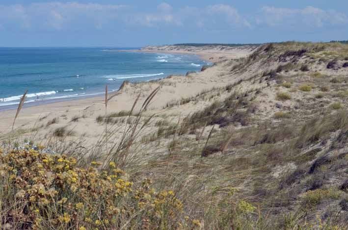
P a r t 2 . Ter r e s t r ia l a n d Fr e s h w a t er H a b i t a t s   1

Foreword
                       Europe is a continent rich in natural and        the Red List tradition, the report provides a comprehensive and
                       cultural heritage with a diverse range           systematic overview of the degree of endangerment of habitats
                       of terrestrial and marine habitats: from         assessed, and summarises data on 490 natural and semi-natural
                       maquis in the south to extensive mires in        habitat types occurring within the European territory of the EU.
                       the north and from sea grass meadows             Together with the current publication, the datasets produced as
                       in shallow areas to cold water coral reefs       part of this work are made publicly available in various formats.
                       in the ocean depths. Over the centuries,         They will help policy makers assess progress towards reaching
                       European landscapes and seascapes                the 2020 biodiversity objectives and targets and support the
have been changed by human activities so that now the continent         implementation of relevant EU legislation, such as the Habitats
is covered with a mosaic of natural and semi-natural habitats           Directive and the Marine Strategy Framework Directive. They can
surrounding urban and other intensively used land. Similarly,           also be used in a wide range of applications in policy, science and
seabed habitats are extensively altered.                                public awareness work.

While the Habitats Directive focuses on the protection of               I am therefore very proud to present to you this state-of-the-art
approximately 230 threatened and characteristic European                piece of work.
terrestrial, marine and freshwater habitat-types, in DG Environment
we wanted to bring together in a systematic manner available
knowledge about the status of all European habitats. This first
ever European Red List of Habitats is the result of an extensive
and thorough assessment carried out by Alterra and IUCN with the        Daniel Calleja Crespo
support of a wide range of experts across Europe. In keeping with       Director-General of DG Environment

Abstract
The European Red List of Habitats provides an overview of the risk      amount of threatened habitats was higher in the EU28 (36%) than
of collapse (degree of endangerment) of marine, terrestrial and         in the wider range of the EU28+ (31%). The European Red List of
freshwater habitats in the European Union (EU28) and adjacent           Habitats provides extensive additional information on habitat
regions (EU28+), based on a consistent set of criteria and categories   classification and definition, pressures and threats, conservation and
and detailed data and expertise from involved countries1. Amongst       restorability of habitats, distribution, status and trends in individual
terrestrial and freshwater habitats the highest percentage of           countries, and sub-habitats that may possibly be threatened. The
threatened types (categories Critically Endangered, Endangered,         information provided can inform and support European nature and
Vulnerable) was found amongst mires and bogs (85% in the EU28,          biodiversity policy in a variety of ways, particularly in relation to the
54% in the EU28+), followed by grasslands (53%, 49%), freshwater        EU2020 Biodiversity Strategy targets. Further applications include
habitats (46%, 38%) and coastal habitats (45%, 43%). Relatively         the revitalisation of the EUNIS habitat classification, synergies with
low percentages of heathland and scrub, forests, and sparsely           the Mapping and Assessment of Ecosystems and their Services
vegetated habitats were assessed to be threatened. Overall the          initiative, and the improvement of Red List methodologies.

1
    http://ec.europa.eu/environment/nature/knowledge/redlist_en.htm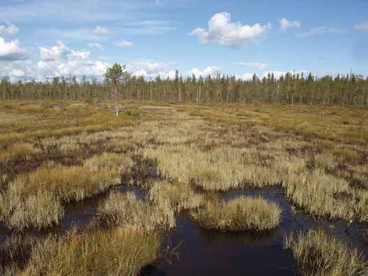
2   European Red List of Habitats

    Executive Summary
    Measuring progress to the EU2020 Biodiversity Strategy, aimed at           All EU28 habitats (n=228)            All EU28+ habitats (n=233)
    halting loss of ecosystem extent and quality, needs reliable and timely
    information on the status and trends of biodiversity across Europe. To                     2%                                    2%
    supplement existing European species Red Lists2, the European                         5%                                    6%
    Commission has extended this approach to the status assessment of                           11%                                   10%
    European terrestrial, freshwater and marine habitats to deliver an
    effective reporting frame for assessing their current status and future
                                                                                                      24%                                   20%
    prospects. This will complement conservation status assessments on
                                                                                 46%                                   50%
    those habitat types included in the Habitats Directive Annex I and the
    Marine Strategy Framework Directive (MSFD).                                                12%                                        12%

    This publication summarises the results of the European Red List
    for terrestrial and freshwater habitats. It provides an overview on            Key:
    the character, extent and status of 233 natural and semi-natural,              ■ Critically Endangered (CR)         ■ Least Concern (LC)
    terrestrial and freshwater habitat types through assessments                   ■ Endangered (EN)                    ■ Data Deficient (DD)
    undertaken between 2013 to 2016. The results are presented                     ■ Vulnerable (VU)                    (n=number of habitats)
    at two geographic levels: across the EU28 and EU28+, including                 ■ Near Threatened (NT)
    Norway, Switzerland, Iceland, and the Balkan countries.

    The publication outlines the development of a Red List typology           Of the criteria used to derive the assessment, three were most
    which, following the Feasibility Study (Rodwell et al. 2013), used a      frequently decisive: Trend in extent over the past 50 years (criterion
    modification of the EUNIS habitat classification (Davies et al. 2004,     A1), Trend in quality over the past 50 years (criterion C/D1) and
    EUNIS 2007), a scheme integral to policy delivery for the European        Long-term historical decline in extent (criterion A3). Restricted
    Commission and already widely used by Member States and NGOs              geographical occurrence (criterion B) was decisive in only relatively
    across Europe. The criteria and categories applied in the European        few cases and Quantitative analysis to assess probability of
    Red List of Habitats are based on modifications of proposals for          collapse (criterion E) was used only once.
    ecosystem risk assessment in the IUCN Red List of Ecosystems
    Categories and Criteria (Keith et al. 2013, IUCN 2016).                   The main pressures and threats vary considerably across the
                                                                              different groups but overall, various kinds of agricultural activities
    Territorial data for the EU28 and the EU28+ countries were                are the most widespread and severe dangers to European terrestrial
    collected through a network of over 150 experts from 33 countries         and freshwater habitats. These include both intensification for
    who supplied information on the area of habitat, trends in quantity       more productive farming and abandonment of traditional land-use,
    and quality (over the past 50 years), long-term and future trends,        changes which especially affect Grasslands. Exploitation for peat
    pressures and threats, conservation measures, data sources and            and shifts to forestry, together with associated modification of
    supporting literature used. These background supporting data are          hydrological process, have been particularly threatening for Mires
    available online through the European Environmental Agency (EEA)          and bogs and direct and indirect effects of hydrological change,
    website.                                                                  together with eutrophication from farming, have also severely
                                                                              affected Freshwater habitats. For Coastal habitats in particular,
    Overall, 36% of the habitats assessed (31% for EU28+) were in the         urbanisation and associated infrastructure and communications
    three threatened categories: Critically Endangered (less than 2% of       continue to be threatening. The impact of climate change is as
    the total), Endangered (11%) and Vulnerable (24%). An additional          yet hard to assess, but some changes are clear and probably
    12% were in the Near Threatened category as defined using the             increasing, particularly with higher temperatures in the Arctic and
    thresholds proposed for this assessment. Only 12 habitats (15 in          at high altitudes.
    the EU28+) were Data Deficient and unable to be assessed, mostly
    remote and poorly known habitats.                                         The publication also reviews the geographic scope of the Red
                                                                              List assessment and variation across Europe in degrees of
    The main part of this publication presents the results of the             endangerment to habitats, the adequacy of the typology, the
    assessment under seven broad habitat headings: Coastal,                   gaps and uncertainties in the data, and the robustness and
    Freshwater, Mires and bogs, Grasslands, Heathland and scrub,              comprehensiveness of the assessment criteria.
    Forests, and Sparsely vegetated habitats. The percentage of
    threatened types differs considerably among the seven major               The general values of the Red List for European environmental
    habitat groups. Mires and bogs are the most threatened groups             policy are outlined and three particular applications illustrated: for
    of habitats in the EU28 (with 85% in the threatened categories),          the mapping of ecosystems and their services, for the restoration
    followed by Grasslands (53%), Freshwater habitats (46%) and               of habitats, and for characterising distinctive landscapes of high
    Coastal habitats (45%). The Forests, Heathland and scrub, and             importance for biodiversity and culture.
    Sparsely vegetated habitats have relatively low proportions of
    threatened types (respectively 29, 14 and 10%).                           Conclusions summarise the achievements and implications of the
                                                                              European Red List of Habitats and highlight some possible next steps.
    2
        http://ec.europa.eu/environment/nature/knowledge/index_en.htm
P a r t 2 . Ter r e s t r ia l a n d Fr e s h w a t er H a b i t a t s   3

1. Introduction
1.1 Background                                                             European Assessment Boundaries
                                                                               European Union member states
To underpin the EU2020 Biodiversity Strategy adopted in 2011,                  Additional countries EU28+
                                                                               Marine Assessment areas
the European Council has committed itself to a long-term vision
and mid-term headline target: “to halt the loss of biodiversity and
the degradation of ecosystem services in the European Union by
2020, restore them in so far as feasible, while stepping up the EU
contribution to averting global biodiversity loss”.

It is impossible to measure progress to this target without reliable
and timely information on the status and trends of biodiversity
across Europe. In order to improve available knowledge, Red
Lists have been compiled by IUCN, HELCOM and many national
teams for different groups of species, both at the EU28 level, at
a pan-European scale and in different countries. Extending the
Red List approach to European habitat types, including terrestrial,
freshwater and marine, will complement the listing of habitats
requiring conservation measures in the European Union such as             Figure 1.1 Assessment boundaries for the European Red List of
those included in the Habitats Directive Annex I and the Marine           habitats. Terrestrial and freshwater regions are given in green (EU28)
Strategy Framework Directive (MSFD).                                      and orange (additional countries EU28+), marine regions in dark blue.

In combination with European Red Lists of species, knowledge on
the status and trends of habitats should deliver synergistic added
value. Since habitat degradation and loss often precede species           1.2 Aims and scope of the assessment
decline, the Red List assessment of habitats provides valuable
signals of upcoming problems for threatened species and their             The main aim was to assess the Red List status of all natural
protection. In addition, it could help identify possible future threats   and semi-natural terrestrial and freshwater habitat types at two
to habitats and scope the possibilities of their restoration under        geographic levels: EU28 and EU28+, including Norway, Switzerland,
the EU2020 Biodiversity Strategy, where there is an associated            Iceland, and the Balkan countries (Figure 1.1).
action of at least 15% restoration of degraded ecosystems under
Target 2.                                                                 Two Red List publications have been produced, one for terrestrial/
                                                                          freshwater habitats, one for marine, and factsheets for all the
Since habitat types represent an important and widely-used scale          habitats. The contents of each factsheet are shown in Figure 1.2
for classifying and understanding ‘ecosystems’, assessments of            and these, together with raw territorial data and distribution
their status and trends should also contribute to the evaluation of       maps are available for public download through the website of
the services which ecosystems can deliver.                                the European Environmental Agency (EEA).

 Figure 1.2 Contents of Red List habitat factsheet.

 Habitat code and name
 • Summary (providing a summary description, distribution, threats, conservation)
 • Synthesis (Red List category and justification)
 • Sub-habitat types (requiring further examination)
 • Images (with brief text description and provider)
 • Habitat description (including characteristic species and indicators of quality)
 • Classification (relationships to EUNIS, EuroVeg Checklist, Annex I, Emerald, MAES, IUCN and other relevant classifications)
 • Geographic occurrence (km2 extent in countries/sea regions in the EU28 and EU28+, summary of trends in quantity and quality)
 • EOO (Extent of Occurrence, in km2) and AOO (Area of Occupancy, number of 10x10 km grid cells)
 • Map (known distribution from modelled or surveyed data and expert opinion)
 • Proportion of habitat in EU28 (%, compared to the worldwide distribution)
 • Trends in quantity and quality (text summaries)
 • Pressures and threats (using Article 17 and MSFD typology)
 • Conservation and management measures (using Article 17 typology and indication of restorability)
 • Red List assessment (with confidence measure, lists of assessor, contributors, reviewer and dates of assessment and review)
 • References (most relevant ones)
4   European Red List of Habitats

    2. Methodology
    2.1 The work flow                                                      was considered too broad for Red List assessment across Europe.
                                                                           Many of the proposed Red List habitats were also renamed. The
    The European Red List of Habitats project was carried out in           resulting list consists of 233 terrestrial and freshwater habitat
    the stages indicated in Figure 2.1, coordinated through a single       types, the numbers in the main groups shown in Table 2.1 and all
    Management Team.                                                       habitats listed in Annex A.

    For terrestrial and freshwater habitats a Habitat typology             The resultant habitats for Red List evaluation were defined
    based on the EUNIS Classification was produced by an expert            especially for this assessment task and were not intended as an
    group together with standardised habitat definitions to aid            official revision of EUNIS level 3. However, proposals were aligned
    recognition. Data for each of these habitats were gathered in the      with the emerging revision of by the European Environment Agency
    EU28 and EU28+ countries by Territorial Experts and delivered          (Schaminée et al. 2012–2016). The final EUNIS typology aims to
    to seven Habitat Working Groups (HWGs), through which the              include all Europe, but some habitat types were not included in
    overall European assessments were made. The seven terrestrial/         the Red List assessment, as these occur only in Ukraine, Belarus,
    freshwater HWGs were based on the major habitats in the EUNIS          Moldova, Russia, the Caucasus and/or European Turkey, outside
    typology (B Coastal, C Freshwater, D Mires and bogs, E Grasslands,     the scope of the Red List project.
    F Heathland and scrub, G Forests and H Sparsely vegetated
    habitats) and comprised four to eight experts from different           The description of each habitat provides the definition, which is
    countries. Training exercises and workshops with the HWGs were         accompanied by relationships to other classifications (see Figure
    held to ensure a standardised approach in applying the criteria        1.2), like the Habitats Directive Annex I types and the EuroVeg
    and categories to the available data and to learn how to use an        Checklist alliances (Mucina et al. 2016, in print).
    online platform on which assessments were made. Assessments
    were then passed to Reviewers and any substantial changes
    agreed with the HWG assessor.
                                                                           2.3 Categories and Criteria
                                                                           The Categories and Criteria applied in the European Red List
    2.2 Habitat typology                                                   of Habitat Types assessment are largely based on a protocol
                                                                           proposed in a feasibility study (Rodwell et al. 2013), combined
    As recommended in the Feasibility Study (Rodwell et al. 2013)          with elements of the IUCN Red List of Ecosystems approach (Keith
    the EUNIS habitat classification (Davies et al. 2004, EUNIS            et al. 2013, IUCN 2016).
    2007) was used as a basis for the Habitat typology, the level 3
    divisions pitched between the fine scale offered by the alliances of   The basis for this European Red List of habitats is a set of
    phytosociology and a broad classification of ecosystems. Mosaic        eight categories and five criteria that provide a method for
    habitat types (EUNIS group X) and highly anthropogenic habitats        assessing the risk of habitat collapse, a measure of degree of
    were omitted, except those thought to be threatened or of interest     endangerment. The Red List Categories are: Collapsed (CO),
    for their biodiversity. Salt marshes (grouped in EUNIS under marine    Critically Endangered (CR), Endangered (EN), Vulnerable (VU), Near
    habitats) were included with other coastal habitats. The existing      Threatened (NT), Least Concern (LC), Data Deficient (DD), and Not
    EUNIS habitats were reviewed and revised and definitions adapted       Evaluated (NE) (Figure 2.2, Box 2.1). The first six categories are
    where EUNIS types were ambiguous, overlapping or of a scale that       ordered in decreasing risks of collapse, while categories DD and
                                                                           NE indicate that a level of risk cannot be or has not been identified.
                                                                           Habitats listed in any of the CR, EN or VU categories are referred
    Figure 2.1 Flow diagram of the work flow.
                                                                           to as ‘threatened’ (IUCN 2016). These categories are analogous to
                                                                           those of the IUCN Red List of Threatened Species (IUCN 2001) and
                                                                           current details of the categories are given in IUCN (2016).

                                  Finalised
                                assessments                                Table 2.1 Final number of terrestrial and freshwater habitats in the
                                                                           seven main groups.
                                 Review of                                  Coastal                                           30
                                Assessments
                                                                            Freshwater                                        26

                            European Assessments                            Mires & bogs                                      13
                          by Habitat Working Groups
                                                                            Grasslands                                        53

                            Data from countries by                          Heathland & scrub                                 38
                              Territorial Experts             Online
     Training
                                                             platform       Forests                                           42

                                                                            Sparsely vegetated                                31
                               Habitat typology
                                and definitions                             Total                                             233
P a r t 2 . Ter r e s t r ia l a n d Fr e s h w a t er H a b i t a t s   5

Figure 2.2 European Red List of Habitats categories (based on Keith         Table 2.2 European Red List of Habitats criteria (from Keith et al., 2013).
et al., 2013).
                                                                            Criterion A. Reduction in quantity (area or distribution)
                                                                                 A1 Present decline (over the last 50 years)
                                                                                 A2a Future decline (over the next 50 years)
                                                                                 A2b Future/present decline (over a 50-year period including
                                                                                       present and future)
                                                                                 A3 Historic decline

                                                                            Criterion B. Restricted geographic distribution
                                                                                 B1 Restricted Extent of Occurrence (EOO)
                                                                                 B2 Restricted Area of Occupancy (AOO)
                                                                                 B3 Present at few locations

                                                                            Criterion C. Reduction in abiotic quality

                                                                            Criterion D. Reduction in biotic quality
                                                                                 C/D1 Reduction in quality over the last 50 years
                                                                                 C/D2 Reduction in quality in the future or in a period including
                                                                                       present and future
                                                                                 C/D3 Historic reduction in quality

                                                                            Criterion E. Quantitative analysis of probability of collapse
 Box 2.1 Summary of the Red List Categories (modified from Keith
 et al. 2013).

 • Collapsed (CO): A habitat is Collapsed when it is virtually certain      processes, Criteria C and D have been combined in this project
   that its defining biotic or abiotic features are lost, and the           (Criterion C/D), with the option to separate where data were
   characteristic native biota are no longer sustained.                     available. The fifth criterion facilitates the integration of multiple
 • Critically Endangered (CR): A habitat is Critically Endangered           threats and symptoms of collapse in a model that estimates the
   when the evidence indicates that it meets any of the criteria A to       likelihood of collapse over time (Criterion E). Most of these criteria
   E for CR, and is then considered to be at an extremely high risk of
                                                                            have been divided into subcriteria. Details on the criteria, with
   collapse.
                                                                            quantitative thresholds, are provided in Annex B.
 • Endangered (EN): A habitat is Endangered when the evidence
   indicates that it meets any of the criteria A to E for EN, and is then
   considered to be at a very high risk of collapse.                        All habitat types were evaluated against all possible criteria.
 • Vulnerable (VU): A habitat is Vulnerable when the best available         Meeting any one of the criteria qualified a habitat type for listing
   evidence indicates that it meets any of the criteria A to E for VU,      at that level of threat. The overall European Red List of Habitat
   and is then considered to be at a high risk of collapse.                 Types status was the highest category of threat identified by any
 • Near Threatened (NT): A habitat is Near Threatened when it has           of the criteria.
   been evaluated against the criteria but does not qualify for CR,
   EN or VU, but the status and trends are close to qualifying for a
   threatened category.
 • Least Concern (LC): A habitat is of Least Concern when it has
   been evaluated against the criteria and does not qualify for CR, EN,     2.4 Data sources
   VU or NT. Widely distributed and relatively un-degraded habitats
   are included in this category.
 • Data Deficient (DD): A habitat is Data Deficient when there is           Territorial data
   inadequate information to make a direct, or indirect, assessment
   of its risk of collapse. DD is not a category of threat and does not     For each habitat type, data on present area of habitat, trend in
   imply any level of collapse risk. Listing habitats in this category      quantity (over 50 years), trend in quality (over 50 years), long-
   indicates that their situation has been reviewed, but that more          term and future trends, pressures and threats, and conservation
   information is required to determine their risk status.                  measures were collected in a standard format (so-called ‘Territorial
 • Not Evaluated (NE): A habitat is Not Evaluated when it is has not        data sheets’) from individual countries by the Territorial Experts
   been assessed against any of the criteria.                               using local inventories and expertise. For the Red List assessment
                                                                            at European level, the territorial data for each habitat type were
                                                                            combined with other information from literature and expert
The assessment comprises the application of five main criteria              knowledge, and these were used to calculate average European
(Criteria A to E, modified from Keith et al. 2013) which have a set of      trends in quantity and quality and evaluate the habitat against all
quantitative and qualitative thresholds that determine for which            the Red List criteria.
(if any) of the threatened categories a habitat qualifies (Table 2.2).
Two of the criteria assess spatial symptoms of habitat collapse in
terms of declining spatial distribution (Criterion A) and restricted        Distribution maps
spatial distribution (Criterion B). Two criteria assess functional
symptoms (degradation of ecological processes) in terms of                  For each habitat a distribution map was produced from a wide
physical or abiotic degradation (Criterion C) and disruption of             variety of sources (Table 2.3) indicating known occurrences of the
biotic processes and interactions (Criterion D). Given that it often        habitat in 10x10 km grids within EU28+. These maps were used
is difficult or impossible to separate biotic and abiotic degradation       for calculating relevant indicators, like the Extent of Occurrence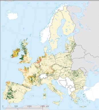
6   European Red List of Habitats

    (EOO) and Area of Occupancy (AOO), see Annex B. Occurrences                  potential distribution based on models or less reliable indicators.
    in grid cells were given in two classes: actual distribution from            An example of a distribution map and the calculated AOO and EOO
    relatively reliable sources (surveys, expert knowledge), and                 is given in Figure 2.3.

    Table 2.3 Data sources used for making distribution maps of terrestrial and freshwater habitats. The given codes of sources are used in the
    GIS-files of the maps.

     Number       Description                                                                                     Code                Reference
         1        Distribution maps of Annex I habitat types provided in the 2013 Article 17 report for the       Art17               EEA,
                  Habitat’s Directive (covering EU27)                                                                                 Copenhagen
         2        European Vegetation Archive (EVA). Dataset of vegetation relevés in Europe, version             EVA                 Chytrý et al.
                  January 2016                                                                                                        2016
         3        Distribution of plant and animal species from the GBIF website, version January 2016            GBIF                www.gbif.org
         4        Natural Vegetation Map of Europe. Potential natural vegetation. Only used for forest types      BOHN                Bohn et al.
                  and other habitats where the potential distribution is likely to be similar to the actual                           2000/2003
                  distribution
         5        European Tree Map, indicating the domiannt tree in an image file. Used for a few forest         ETM                 Hengeveld et al.
                  habitats                                                                                                            2012
         6        National databases of different countries, a.o. Spain (vegetation map), Hungary (habitat        NAT                 -
                  distribution maps), Bosnia and Herzegovina (N2000 database)
         7        Distribution data of ‘wooded grasslands’. This map was compiled in the European project         AGFOR               Plieninger et al.
                  AGFORWARD and was used only for three ‘wooded grassland’ types (E7)                                                 2015
         8        Literature and expert knowledge. Only used for habitats with large distribution gaps in the     EXP, LIT            -
                  previous sources

    Figure 2.3 Example of a distribution map for habitat F4.2 Dry heath. The number of 10x10 km grid cells is the Area of Occupancy (in this case
    8213 for EU28 and 8267 for EU28+), the area of the envelope around the distribution provides a measure for the Extent of Occurrence (in this
    case 6,337,850 km2 for EU28 and 6,541,100 km2 for EU28+).

                                                                                                                                0
                                                                                                                                      Ü        480

                                                                                                                                    Kilometers

                                                                                                                             Legend
                                                                                                                                    Potential distribution
                                                                                                                                    Survey/Expert input
P a r t 2 . Ter r e s t r ia l a n d Fr e s h w a t er H a b i t a t s 7
3. Results
3.1 General overview recent decline in extent of more than 30%: with peat extraction
and conversion to agriculture and forestry are the main and
A Red List assessment was carried out for a total of 233 terrestrial continuing threats. Changes in hydrological functionality by
and freshwater habitats, of which five occur only outside the drainage and abstraction in mire watersheds and eutrophication
EU28. Table 3.1 provides an overview of the final categories for are also threatening and climate change is causing droughts
all habitat types with full details given in Annex A. In total, 36% and, critically important for dependent palsa mires, melting of
(EU28) and 31% (EU28+) of the evaluated habitats are assessed permafrost.
as threatened in categories Critically Endangered, Endangered
and Vulnerable. An additional 12% are Near Threatened in EU28 The 53 Grasslands of Europe comprise an extraordinarily diverse
(15% in EU28+). These figures are slightly higher if Data Deficient and often very species-rich range of habitats that have been a
habitats are excluded. mainstay of pastoral agriculture in every biogeographic region
for centuries. They are widely threatened, particularly certain dry
The percentage of threatened habitats differs considerably grasslands, mesic pastures and meadows, heavy metal grassland
between the seven main groups of habitats. The highest proportion and certain open wooded grasslands. Reductions in extent and
of threatened habitats in the EU28 was found among Mires and quality have been very substantial and widespread due primarily
bogs (85%), followed by Grasslands (53%), Freshwater habitats to ‘improvement’ for agriculture and abandonment of traditional
(46%) and Coastal habitats (45%). Forests, heathland and scrub, pastoralism with the spread of scrub and woodland. Disruption of
and Sparsely vegetated habitats had relatively low proportions of hydrological functioning is damaging to wetter grasslands and, in
threatened types. In the EU28+ the figures of threatened types the alpine belt, warmer winters and longer growing seasons are
are generally slightly lower, but much lower for Mires and bogs. predicted to be a threat.
Details on each group are given in the next sections.
The 26 Freshwater habitats include moving and standing waters
The treeless wetlands on accumulating peat that compose the with submerged, emergent and marginal vegetation, also with
13 Mires and bogs occur widely across Europe, though most saline and brackish habitats inland, some temporary waters and
extensively in the Nordic countries. They have suffered most in a few abiotic types in association with glaciers and ice sheets.
recent times amongst the habitats of Europe with long term and None of these habitats is Critically Endangered but the most
Table 3.1 Overall Red List categories for all terrestrial and freshwater habitats in the EU28 (top) and EU28+ (bottom).
EU28
Heathland Sparsely
Coastal Freshwater Mires & bogs Grasslands & scrub Forests vegetated Total
CR - - 1 3 - - - 4
EN 5 3 3 9 1 2 1 24
VU 8 9 7 16 5 10 2 55
NT 3 7 1 7 2 10 2 27
LC 12 5 1 18 27 19 18 106
DD 1 2 - - 1 1 6 12
total 29 26 13 53 36 42 29 228
threatened % 45 46 85 53 17 29 10 36.4 %
threat. % (excl. DD) 46 50 85 53 17 29 13 37.9 %
EU28+
Heathland Sparsely
Coastal Freshwater Mires & bogs Grasslands & scrub Forests vegetated Total
CR - - 1 3 - - - 4
EN 5 3 2 9 1 1 1 23
VU 8 7 4 14 5 9 2 46
NT 4 7 4 9 1 7 2 29
LC 12 6 2 18 30 20 20 116
DD 1 3 - - 1 3 6 15
total 30 26 13 53 38 42 31 233
threatened % 43 38 54 49 16 24 10 31.3 %
threat. % (excl. DD) 45 43 54 49 16 26 12 33.3 %8 European Red List of Habitats
threatened are characteristic of high salinity or tide-related and mainly because of recent declines in extent and quality with
estuarine fluctuations, many types of open waters, shorelines or an abandonment of traditional management. In fact, such a shift
springs, with widespread recent declines in extent and quality. among grasslands has meant that many losses have been made
Being so important for the provision of water supply, such habitats up by the spread of scrub. Other threats include infrastructure and
are everywhere vulnerable to abstraction and watercourse afforestation, with climatic warming for arctic and high mountain
management but pollution from waste disposal or agricultural and types.
industrial operations is also a widespread threat.
Sparsely vegetated habitats include a diversity of 31 types on
The 30 Coastal habitats include salt-marsh, sand and shingle cliffs, screes, volcanic deposits, moraines and in snow fields, as well
beaches, sand dune, and coastal heath, scrub and woodland as weed communities of traditionally used arable land. Many of
represented in all biogeographic regions of Europe and one also these are remote, hard to survey and little known (so often classed
in EU28+. Much coastal vegetation is truly natural and some still as Data Deficient), their location having provided some protection
subject just to the dynamics of tides and winds. Some habitats from many environmental threats. The most threatened types are
are threatened by having a naturally limited distribution. Dune the weed community, much reduced by shifts to intensive arable
grasslands have experienced widespread declines in extent and cultivation in most parts of Europe, and two abiotic snow and ice
quality, with common threats being from infrastructure and habitats threatened by melting in recent warmer years.
communications, tourism and recreation, the invasion of non-
native plants and pollution. The decisive criteria resulting in the final Red List categories are
summarised in Figure 3.1. Overall three criteria were most often
The Forests of Europe are a diverse constituency of 42 broadleaved, crucial in determining the final Red List category: A1 Trend in
coniferous and mixed types, many of them constituting the
potential natural vegetation of their biogeographic zone, though Figure 3.1 Proportion of different criteria decisive for the final Red
now rarely surviving in pristine condition. They appear to be List result of Threatened and Near Threatened habitats in the EU28
relatively lightly threatened at the present time and mostly in (left) and EU28+ (right) assessments.
wetter habitats on bogs, around open waters or along rivers,
1% 1%
where there have been substantial recent declines in extent and/ 3% 1% 2% 1%
or quality but also including some types at threat because of a
naturally limited distribution. Over a longer time frame, beyond
250 years, huge losses would probably be accountable for many 32% 35% 32% 36%
forest types. The most important threats apart from damage to
natural hydrologic functioning are related to commercial forestry
or over-grazing, and aerial pollution.
6% 16% 1% 6% 18%
2% 2% 1%
Heathland and scrub habitats, which include 30 habitats where
2% 1%
woody sub-shrubs or shrubs dominate, are widespread across
Europe as temporary stages in succession from grasslands to A1 B1 CD1 E
forest, types maintained by repeated grazing and burning or A2a B2 CD2
climax habitats growing in extreme climates. Few are threatened A3 B3 C2
Figure 3.2 Main threats affecting the different European habitat types.
Agriculture extensification and intensification
Urbanisation, roads, transportation
Natural System modifications (a.o. hydrology)
Climate change
Sylviculture, forestry
Natural processes (succession, erosion)
Pollution (nitrogen deposition, groundwater)
Mining (peat, sand, gravel extraction)
Invasive alien species
Sparsely vegetated
Human intrusions and disturbances
Forests
Biological resource use
Heathland
Geological events (volcanic activity)
Grasslands
Outdoor sports, trampling, overuse
Mires and bogs
Forestry, sylviculture
Freshwater
No threats or pressures
Coastal
Fire (natural) and burning
0 20 40 60 80 100 120 140
Number of habitats vulnerable to a threatP a r t 2 . Ter r e s t r ia l a n d Fr e s h w a t er H a b i t a t s 9
quantity over 50 years (36% of all decisive criteria), C/D1 Trend in among the coastal habitats are essentially inland types of heath,
quality over 50 years (32%), and A3 Historical decline in quantity scrub and forest which happen to occur on the coast.
(18%). Restricted geographical occurrence (B1, B2, B3) has been
decisive relatively few times, and E Quantitative analysis was Typological divisions among the coastal habitats of Europe
used only once. have been made in many cases on the basis of geographical
region, often reflected in variation in species composition and
The main pressures and threats vary largely across the different ecological processes. Generally, a separation is made between
groups, as shown in Figure 3.2. Overall, agricultural activities Mediterranean and Black Sea coastal habitats versus Atlantic
are listed most often as a threat to habitats, involving both and Baltic examples, but in cases where these groups still include
extensification of traditional land-use (abandonment) and large differences, further splits have been made.
intensification of land-use, both of these especially threatening
Grasslands and Heathland and scrub. Other main threats are
urbanisation (especially in Coastal habitats), modification of Assessment results
natural systems (especially hydrological systems for Freshwater
habitats, Mires and bogs), climate change, and afforestation of Of the 30 assessed habitats (of which one is occurring only in
treeless habitats. EU28+), 13 qualify for one of the threatened categories of the
Red List, with five being Endangered and eight Vulnerable (Figure
3.4). Four other habitats are assessed as Near Threatened, and of
these one occurs only outside the EU28.
3.2 Coastal habitats
Grasslands are among the most threatened coastal habitats,
European coastlines are dynamic landscapes, influenced by assessed as Endangered. Two types are more or less stabilised
coastal factors like tides and winds but also in many cases Dune grassland (B1.4b, B1.4c), while Dune scrubs of Macaronesia
strongly affected by human activities in the past and present. (B1.6c) is related to grassland, and a fourth Endangered type
Quite a large percentage of the coastal habitats comprise is Baltic coastal meadows (A2.5b). The Endangered Black Sea
relatively natural habitats which do not need any management broadleaved coastal dune woodland (B1.7a) is restricted to
for their survival, for example beach, cliff and foredune types, but Romania and Bulgaria and very rare in both countries.
also, to a large extent, the salt-marsh habitats. Other habitats
contain both natural and semi-natural components, like the grey The eight habitats assessed as Vulnerable consist of one salt marsh
dune types, but only a few habitat types are largely semi-natural type, one beach type and six dune habitats. Two other salt-marsh
in character, notably the Baltic coastal meadows. Also included types have been assessed as Near Threatened. The Vulnerable
Figure 3.3 Coastal dunes along the Atlantic Ocean in South-west France. © John Janssen10 European Red List of Habitats
Figure 3.4 Overall assessment of coastal habitats in the EU28 Figure 3.5 Percentage of threatened coastal habitats in EU28 for
and EU28+. (n=number of habitats) different structural groups.
EU28 (n=29) EU28+ (n=30) 100%
90%
4% 3%
80%
17% 17% 70%
60%
41% 40% 50%
28% 27% 40%
Critically Endangered 30%
10% Endangered13% 20%
Vulnerable
10%
Critically Endangered Near Threatened
Endangered Least Concern 0%
h) d k) b t ks
Vulnerable Data Deficient
e ac sl an l ac cr u res r oc
yb es /s Fo nd
Near Threatened d ra s n a nd a
an G (du ath
l
ffs
Least Concern r (s Mi
re He C li
n ee
dune habitats include Atlantic and Baltic white dunes (B1.3a),
Data Deficient Pio
Atlantic and Baltic grey dunes (B1.4a), coastal Empetrum heath Data Deficient Least Concern Near Threatened Threatened
Data Deficient Least Concern Near Threatened Threatened
(B1.5a), Mediterranean and Black Sea coastal dune scrub (B1.6b),
Baltic coniferous forests (B1.7d) and Atlantic and Baltic wet dune
slacks (B1.8a). The two heathland/scrub types are presently in a Figure 3.6 Percentage of threatened coastal habitats in EU28 for
stable condition or even increasing, but have undergone a large different geographic regions.
historical decline.
100%
Thirteen habitats have been assessed as Least Concern. These 90%
include all coastal rocky habitats (cliff types and pebble beaches),
with the exception of one soft sea cliff, for which too few data 80%
are available, resulting in the Data Deficient designation. Further
70%
more, one beach type, two heathland and scrub habitats, two
forest types, and one dune slack type are of Least Concern. 60%
50%
The overall picture of the coastal results reflect the results of all
other groups. Relatively many grassland habitats are Threatened, 40%
a few rocky habitats are relatively little Threatened, and all other
types are in between (Figure 3.5). Especially for heathland/scrub 30%
and forest types the proportion of Threatened types is a bit
20%
higher than for inland habitats. In the Atlantic, Arctic and Baltic
region slightly more coastal habitats have been assessed under 10%
a Threatened category than in the Mediterranean, Black Sea and
Macaronesia (Figure 3.6). 0%
Atlantic, Baltic, Arctic Mediterranean, Black Sea,
Macaronesia
Data Deficient Least Concern Near Threatened Threatened
Box 3.1 Threatened Coastal habitats.
■ Endangered
A2.5b Baltic coastal meadow Main pressures and threats
B1.4b Mediterranean and Macaronesian coastal dune grassland
(grey dune)
The coastal zone of Europe is one of the most intensively
B1.4c Black Sea coastal dune grassland (grey dune)
B1.6c Macaronesian coastal dune scrub
frequented areas by humans. Since early historic times it has
B1.7b Black Sea broad-leaved coastal dune woodland provided food (notably, fish and shellfish) and good conditions
for transport, especially in estuaries. Many large cities have been
■ Vulnerable built in the vicinity of a river mouth, and their expansion has put
A2.5c Atlantic coastal salt marsh pressures on the natural ecosystems in these sites. During the
B1.1a Atlantic, Baltic and Arctic sand beach last century, tourism has increased enormously, adding an extra
B1.3b Mediterranean and Black Sea shifting coastal dune pressure to all coastal areas. Building of houses and associated
B1.4a Atlantic and Baltic coastal dune grassland (grey dune) infrastructure is seen in many coastal areas, because living here
B1.5a Atlantic and Baltic coastal Empetrum heath is often rewarded with wonderful scenery and an equable climate.
B1.6b Mediterranean and Black Sea coastal dune scrub
Not surprisingly, urbanisation is the most important threat to all
B1.7c Baltic coniferous coastal dune woodland
coastal habitats (Figure 3.7), followed by recreational (over)use
B1.8a Atlantic and Baltic moist and wet dune slack
by people. Invasive non-native species form the next importantP a r t 2 . Ter r e s t r ia l a n d Fr e s h w a t er H a b i t a t s 11
Figure 3.7 Number of coastal habitats vulnerable to different
pressures and threats.
3.3 Freshwater habitats
0 5 10 15 20 25 30 The freshwaters of Europe comprise 26 habitats mainly dominated
Urbanisation, roads
by plants that are strictly aquatic, emergent or amphibious, or
Biological resource use (fishing)
by grasses or herbs that are adapted to occasional floods and
Mining (peat, sand, gravel extraction)
able to develop during dry periods. As defined here, freshwater
Outdoor sports, trampling, overuse
habitats include also inland brackish and saline water bodies and
Invasive alien species a few habitats totally without vegetation, such as underground
Pollution (waste, oil spill) waterbodies or lakes developed on glaciers or ice sheets.
Agriculture intensification, cultivation
Hydrological System modifications Freshwater habitats are widely distributed across Europe, but
Agriculture extensification… vary in character and distribution according to climatic and
Erosion (natural) geomorphological conditions. Permanent water bodies are mainly
Forestry, sylviculture concentrated in the northern and Atlantic regions, while the
Pollution (nitrogen deposition,… temporary ones are more typical in areas with a Mediterranean
Climate change (sea level rise) climate. Some of these habitats can be part of very broad
Succession ecosystems (like long rivers or large lakes), while others occur
Fire (natural) and burning as small and localised patches (like springs or ponds). Natural or
anthropogenic supplies of nutrients and minerals are important
factors determining the species composition of the biotic part of
most freshwater habitats and they can be grouped according to
their trophic level, whether they are oligotrophic, mesotrophic,
eutrophic or dystrophic, or exhibit a range of such conditions.
threat in coastal habitats (Figure 3.8), not only in the relatively
open types such as beaches, white dunes and cliffs, but also in Plant communities characterising freshwaters are generally
more stabilised ecosystems, like grey dunes and forests. More species-poor, but some of these habitats host a contingent of
specific pressures and threats are pollution (to beach habitats), locally rare or scarce species. Many characteristic plant species
agricultural intensification and abandonment (in dune grasslands have a relatively wide range, as they are easily dispersed by water
and salt marshes), hydrological modifications (dune slacks, salt fowl. Besides vascular plant, bryophyte and algal communities,
marshes), erosion (cliffs, foredunes) and sea level rise due to most freshwaters are also characterised by distinctive fauna,
climate change (beaches, salt marshes). especially invertebrates, but sometimes also vertebrates (notably
fish and amphibians), which sometimes also host high numbers of
a) endemics or rare species.
b)
Data quality and gaps
Most freshwater habitats provide essential resources and services
Data provided for coastal habitats were relatively good and such as drinkable water, supplies of fish, building materials
complete, partly because of the good relationship with Annex (such as sand, gravel or stones), hydroelectric power, water for
I-types where Article 17 reporting under the Habitats Directive agricultural and industrial use and recreation services.
was a valuable source of information. Exceptions were the two
soft cliff types, which have rarely been distinguished in other
habitat typologies, and for which little knowledge exists. One of Assessment results
these was assessed as Data Deficient. Another data problem was
the area estimation of beach and cliff types, which differs largely Forty percent of these freshwater habitats are threatened in the
between countries and has to be considered relatively uncertain. EU28, slightly less in the EU28+ (Figure 3.10) and the threatened
Figure 3.8 Rosa rugosa is an invasive shrub originating from Japan Figure 3.9 Pärnu river in the lowlands of Estonia, an example of
that threatens dune grassland and shrubland, like here on the habitat: Permanent non-tidal, smooth-flowing watercourse (C2.3).
Wadden Sea island of Vlieland. © John Janssen © John Janssen
c) d)12 European Red List of Habitats
Figure 3.10 Overall assessment of freshwater habitats in the EU28 Figure 3.11 Assessment results in the EU28 for different subgroups
and EU28+. (n=number of habitats) of freshwater habitats.
100%
EU28 (n=26) EU28+ (n=26)
90%
8% 11% 12% 11% 80%
70%
19%
60%
23% 27%
35% 50%
40%
27% Critically Endangered
27% 30%
Endangered
Vulnerable 20%
Critically Endangered Near Threatened 10%
Endangered Least Concern
0%
Vulnerable Data Deficient t 5) 4) )
en g
nin ) =1
Near Threatened an =9) un (n=7 (n= (n= r (n
e m
r s( n R re s ds ate
P ie s ho be w
Least Concern d r se S te nd
Data Deficient er bo c ou ph
y
ou
wa
t ter el o r gr
wa H de
Un
habitats are relatively evenly divided between different subgroups
Data Deficient Least Concern Near Threatened Threatened
of freshwater habitats (Figure 3.11). The three Endangered
habitats are characterised by very specific ecological conditions,
for example high salinity (C5.4, C3.5c) or tidal fluctuations (C2.4), The Near Threatened habitats include some of the most
that make these habitats exclusive to some geographic areas. common freshwater habitats in Europe such as Oligotrophic and
They have been destroyed to a large extent during recent or mesotrophic to eutrophic water body (C1.1a, C1.2b), Dystrophic
historic time, mainly due to land reclamation for human activities water body (C1.4), Smooth flowing watercourse (C2.3), Periodically
and direct or indirect changes of the natural hydraulic conditions. exposed shore with eutrophic sediments (C3.5b) and Small-
helophyte bed (C5.1b), but also one rare type (saline and brackish
The Vulnerable freshwater habitats include some that, though water body, C1.5). Despite their frequency and large extent across
relatively abundant across Europe, are limited in extent in each Europe, all these habitats are near-threatened because of large
site, such as Mediterranean temporary ponds (C1.6b), Base- declines in abiotic and biotic quality during the last 50 years.
poor and Calcareous springs (C2.1a, C2.1b), Periodically exposed
shores with stable, mesotrophic sediments (C3.5b), and Lakes of
glaciers and ice sheets (C1.7). Others are limited to situations with Main pressures and threats
particular physical or chemical conditions such as waterbodies
with Characeae (C1.2a), Turbulent water courses with Ranunculus The most important and devastating threats for Freshwater
spp. (C2.2b), Sparsely vegetated shores with mobile sediments of habitats are all related to human activities (Figure 3.12). The
montane and alpine regions (C3.5d) and Tall-sedge dominated first is change in the hydraulic conditions of water bodies, among
habitats (C5.2). These habitats are now Vulnerable due to recent which direct effects can stem from the constructions of dykes or
large declines in extent or in quality (criterion A1 and C/D1). artificial banks along the watercourses, water abstraction and
alteration of the water level of lakes, ponds and rivers for fishing,
agriculture and energy production. Threatening indirect actions
Box 3.2 Threatened freshwater habitats.
■ Endangered
C2.4 Tidal river, upstream from the estuary Figure 3.12 Number of freshwater habitats vulnerable to different
C3.5c Periodically exposed saline shore with pioneer or ephemeral pressures and threats.
vegetation
0 5 10 15 20 25 30
C5.4 Inland saline or brackish helophyte bed
Hydrological system modifications
■ Vulnerable Climate change
C1.2a Permanent oligotrophic to mesotrophic waterbody with
Pollution (water)
Characeae
C1.6b Mediterranean temporary waterbody Invasive alien species
C1.7 Permanent lake of glaciers and ice sheets (EU28 only) Agriculture intensification, cultivation
C2.1a Base-poor spring and spring brook (EU28 only)
Mining (peat, sand, gravel extraction)
C2.1b Calcareous spring and spring brook
C2.2b Permanent non-tidal, fast, turbulent watercourse of plains Succession
and montane regions with Ranunculus spp. Biological resource use (fishing)
C3.5b Periodically exposed shore with stable, mesotrophic
Urbanisation, roads
sediments with pioneer or ephemeral vegetation
C3.5d Unvegetated or sparsely vegetated shore with mobile Geological events (volcanic activity)
sediments in montane and alpine regions Forestry, sylviculture
C5.2 Tall-sedge bed
Outdoor sports, trampling, overuseYou can also read