Evaluating Multispectral Imaging for Assessing Bacterial Leaf Blight Damage in Indonesian Agricultural Insurance
←
→
Page content transcription
If your browser does not render page correctly, please read the page content below
E3S Web of Conferences 232, 03008 (2021) https://doi.org/10.1051/e3sconf/202123203008
IConARD 2020

 Evaluating Multispectral Imaging for Assessing
 Bacterial Leaf Blight Damage in Indonesian
 Agricultural Insurance
 Yuti Giamerti1,*, Chiharu Hongo2, Daiki Saito3, Oliver Caasi4, Pepi Nur Susilawati1,
 Masahiro Shishido4, I Putu Sudiarta5, I Made Anom Sutrisna Wijaya6, Koki Homma3
 1 Banten Assessment Institute for Agricultural Technology Indonesian Ministry of Agriculture, Ciruas
 Serang, Banten 42182, Indonesia
 2 Center for Environmental Remote Sensing, Chiba University, 1-33 Yayoi-cho, Inage-ku, Chiba-shi,

 Chiba 263-8522, Japan
 3 Graduate School of Agricultural Science, Tohoku University, 468-1 Aramaki Aza Aoba, Aoba-ku,

 Sendai, Miyagi 980-8572, Japan
 4 Graduate School of Horticulture, Chiba University, 648 Matsudo, Matsudo-shi, Chiba 271-8510,

 Japan
 5 Faculty of Agriculture Udayana University, Jl. P.B Sudirman Denasar Bali
 6 Faculty of Agriculture Engineering Udayana University, Jl. P.B Sudirman Denpasar Bali.

 Abstract. Bacterial Leaf Blight (BLB) is one of the main diseases in
 Indonesia that causes a 90% reduction in grain weight. Multispectral
 imaging may be used as a quick and effective method for damage assessment
 and is expected to utilize on agricultural insurance in Indonesia. Data were
 collected at the rainy season and dry season 2018 in Farmers rice field at
 Bali Province. Vegetation indices (NDVI, GNDVI, and VARIred-edge) was
 analyzed using QGIS 2.18 from multispectral images. Some vegetation
 index shows positive correlation with SPAD and negative correlation with
 DSI (%). VARIred-edge has a higher relationship with DSI (R2: 0.8443) than
 NDVI (R2: 0.8291) and GNDVI (R2: 0.5463) at the average value on each
 location, but the relation seems to be affected by that relation between SPAD
 and LAI. Further data and analysis are required.

 1 Introduction
 Bacterial Leaf Blight disease is one of the main rice diseases in Indonesia because BLB
 spread almost all over in the Indonesian region, and the severity has reached a high level
 especially in the rainy season. Rice can be attacked by BLB from nursery to harvest and is
 identified as a seed-borne pathogen [1]. Grain weight reduction due to BLB can reach 90%
 this happened because of the increase in infection rates [2].
 BLB infected rice plants on the leaves through leaf wounds or natural holes in the stomata
 and damage chlorophyll. Sympthoms start from the edge of the leaves giving a stripped
 appearance, are grayish and became dry. Therefore, the severity of disease due to BLB
 possible to assess based on remote sensing image according to the attack severity.

 * Coresponding author: yuti.giamerti@gmail.com

© The Authors, published by EDP Sciences. This is an open access article distributed under the terms of the Creative Commons
Attribution License 4.0 (http://creativecommons.org/licenses/by/4.0/).
E3S Web of Conferences 232, 03008 (2021) https://doi.org/10.1051/e3sconf/202123203008
IConARD 2020

 Monitoring disease through remote sensing technology will be more efficient and make
 it easier to make quick decisions for pest and disease control in field. Direct detection of
 plants leaves infected with pests and diseases so that appropriate handling can only be
 carried out at specific infected locations. Several recent studies on remote sensing have
 found feature extraction and algorithms carried out at various scales, so that new possibilities
 for detecting pests and plant diseases from the air are known [3]. Furthermore, some studies
 clarify regarding the detection of the severity of BLB attack, it was found that vegetation
 indices can be used to detect crop disease seen in the canopy by estimating the chlorophyll
 contained in these plants [4, 5]. This information supports the determination of the severity
 of plant diseases and the appropriate strategy in terms of assessing the damage in
 agricultural in Indonesia.
 Indonesia has implemented agricultural insurance since 2013 to protect the farmers from
 losses due to damage (drought, flood, pest and diseases attack), but in the implementation of
 agricultural insurance, some obstacles faced by the Indonesian government include of lack
 of farmer awareness, difficult in dissemination of agricultural insurance, need a lot of human
 resources, and the assessment conducted by human eyes so would be time, cost and energy-
 consuming. Accordingly, remote sensing may be used as a quick and effective method for
 damage assessment formulation and monitoring for agricultural insurance policy claims [6,
 7].
 Recently, monitoring crops using Unmanned Aerial Vehicle (UAV) has been introduced
 into agricultural study [8]. The main advantages are simple operating with less manpower
 and imaging below the cloud cover [9]. The drone is also made a remote sensing image most
 appropriate for the smaller area and a small plot that the most used in rice fields in Indonesia.
 For this reason, it is important to consider a new method for assessing damage due to pest
 and diseases in Indonesian Agricultural Insurance, therefore the aim of this research is to
 evaluate multispectral imaging for assessing Bacterial Leaf Blight (BLB) damage.

 2 Method and data analysis
 Data were collected at the rainy season and dry season 2018 in Farmers rice field at Bali
 Province (Table 1). Rice disease intensity using Disease Severity Index (DSI) was measured
 and calculated by the pest observer at the same point with GPS, SPAD and LAI measurement.
 The number of observations points to collect the data is 30-50 point of each location.
 Table 1. Location and data measurement at the rainy season and the dry season 2018.
 Rainy Season Dry Season
 Location Bali: Bali:
 - Cemangi regency - Sembung district, Badung regency (Ciherang,
 (Ciherang, 45-60 DAT*)) 75-80 DAT)
 - Kekeran regency - Kuwum district, Badung regency (Ciherang,
 (Ciherang, 45-60 DAT; 90-100 20-30 DAT and
 DAT) 90-100 DAT)
 Ground - Marking checkpoint by GPS - Marking checkpoint by GPS
 data - Measurement Leaf Area Index - Measurement Leaf Area Index (LAI) in the
 (LAI) in the GPS point by LI- GPS point by LI-COR LAI-2200
 COR LAI-2200 - Measurement leaf greenness by Minolta
 - Pest and disease intensity by pest SPAD 502
 observer - Pest and disease intensity by pest observer
 Drone - Phantom 3 - DJI Mavic Pro
 data - Camera: Sequoia - Camera: Sequoia
 - Software to take an image by - Software to take an image by drone: Precision
 drone is Atlas flight flight
 *) DAT: Day After Treatment

 2
E3S Web of Conferences 232, 03008 (2021) https://doi.org/10.1051/e3sconf/202123203008
IConARD 2020

 Rice plant in the GPS point was observed and measured the harmfulness in the rice plant
 due to BLB damage using scoring, scoring that we used in this study based on technical
 instructions of pest observer, Indonesian Ministry of Agriculture on the Table2.
 Table 2. The scoring method for BLB damage
 Score 0 1 3 5 7 9
 Percentage of BLB attacks on rice tillers in 1- 6- 26- 51- 76-
 0%
 a clump 5% 25% 50% 75% 100%
 Furthermore, using the score of BLB attack, Disease Severity Index (DSI) was calculated
 as:

 ∑ =0( × )
 DSI (%) = x100 (1)
 ×

 Where ni is the class frequency or the number of tillers/part of the sample plant with a
 score of damage vi, vi is the damage score at the sample plant (Score of rating class), N is a
 total number of observations and Z is the maximal disease index.
 Vegetation indices (NDVI, GNDVI, and VARIred-edge) was analyzed using QGIS 2.18
 from multispectral images, these vegetation indices were calculated as:
 −
 NDVI = (2)
 +
 −
 GNDVI = (3)
 +
 _ −
 VARIred-edge = (4)
 _ +

 (a) (b)

 (c)
 Fig 1. Vegetation indices images: (a) NDVI, (b) VARI red-edge, (c) GNDVI calculation from
 multispectral images.

 3
E3S Web of Conferences 232, 03008 (2021) https://doi.org/10.1051/e3sconf/202123203008
IConARD 2020

 3 Result and Discussion
 Xanthomonas oryzae pv. oryzae that causes BLB is the oldest and main bacterial rice disease
 in tropical and subtropical county [10], however, losses caused by BLB in the tropics is
 higher than in the subtropical region, a worldwide concern as well because that bacterial
 disease harm many rice fields regions of the world [11].
 The differences of BLB attack in Bali between rainy season and the dry season is shown
 in Figure 2 which indicates that the most of BLB attack intensity at rainy season is on score
 0 and in the dry season is on score 1. Nevertheless, in the dry season even though there were
 BLB attacks, it was included in minor damage, while in the rainy season BLB attacks reached
 the highest score (score 9), more details can be seen in Table 3 and 4, the tables shows clearly
 that BLB damage in the rainy season is higher than in the dry season from DSI. In the rainy
 season Disease Severity Index (DSI) is higher than in the dry season especially at Sembung
 1, higher DSI means the rice crops suffered more, this condition occurs due to environment
 factors in the rainy and the dry season affect the pathotype diversity of that bacterial [12],
 moreover, humidity in the rainy season is higher than the dry season, the air temperature in
 the rainy season also has the potential for the groth of BLB well.

 Dry season Rainy season

 2500

 2000

 1500
 TILLER

 1000

 500

 0
 0 1 3 5 7 9
 -500
 SCORE

 Fig 2. BLB damage in Bali in the rainy season and the dry season.
 Table 3. BLB attack (tillers) in Bali at the rainy season.
 Location Score
 DSI
 0 1 3 5 7 9
 Sembung 1 159 171 249 116 95 48 33.2
 Sembung 2 1279 251 74 36 3 1 4.67
 Kuwum 1 299 107 55 35 8 0 12.04
 Kuwum 2 101 354 273 79 5 0 21.95

 4
E3S Web of Conferences 232, 03008 (2021) https://doi.org/10.1051/e3sconf/202123203008
IConARD 2020

 Table 4. BLB attack (tillers) in Bali at the dry season.
 Location Score
 DSI
 0 1 3 5 7 9
 Cemangi 1 110 229 173 16 0 0 16.5
 Cemangi 2 116 478 76 10 0 0 11.7
 Cemangi 3 277 354 44 5 0 0 8.9
 Kekeran 1 256 317 16 0 0 0 7.0
 Kekeran 2 419 167 44 0 0 0 5.1
 Kekeran 3 243 350 13 0 0 0 7.3
 The rice crops suffered by BLB are also has a small SPAD value, the evidence was found
 at SPAD value on a Figure 3 that SPAD value at Sembung 1 is lower than the other places.
 Moreover, the DSI at Sembung 1 is higher than the other places. SPAD (chlorophyll meter)
 used for identification plant nitrogen or the greenness of leaf caused by damage. The rice
 leaves that were attacked by bacterial leaf blight indicates a change a leaf color, the greater
 the attack, the less greenness the leves are.

 38
 37
 36
 35
 34
 33
 32
 31
 30
 29
 28
 27
 26
 25
 Sembung_1 Sembung_2 Kuwum_1 Kuwum_2
 Fig 3. Average of SPAD value.
 Relationship between DSI with SPAD and LAI has been analyzed to the evaluation of
 BLB damage on the rice field. The findings showed a negative relationship between DSI with
 SPAD and LAI which mean that the greater the BLB attack, the smaller the SPAD value and
 LAI.
 DSI of BLB attack can be detected more through SPAD than LAI indicated by a higher
 relationship between SPAD with DSI (R2: 0.7879) than LAI (R2: 0.5783) as shown in Figure
 4. Plant symptoms and physiological changes that are caused by pest and diseases, one of
 the symptoms is destruction of pigmen system. Crop damage due to BLB can cause
 destruction of chloroplast or other organelles, leading to change in pigment content.

 (a) (b)
 Figure 4. Relationship between DSI with (a) SPAD and (b) LAI.

 5
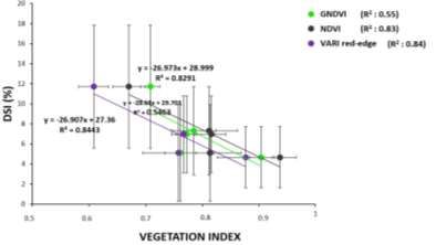
E3S Web of Conferences 232, 03008 (2021) https://doi.org/10.1051/e3sconf/202123203008
IConARD 2020

 Each crop will show different symptoms in response to different diseases. Therefore,
 monitoring for damage due to pests and diseases through remote sensing requires a specific
 response that can be detected by specific sensors or certain vegetation indices so that each
 symptom can be recognized differently.
 The vegetation index is often utilized to evaluate crop health. The evaluation result in this
 study showed that VARIred-edge is the most potent than the three vegetation indices (NDVI,
 GNDVI, and VARIred-edge) tested across BLB damage. The result shows that VARIred-edge has
 a higher relationship with DSI (R2: 0.8443) than NDVI (R2: 0.8291) and GNDVI (R2: 0.5463)
 at the average value on each location as shown in Figure 5. Crop have certain plant reflection
 changes against crop diseases.
 Red-edge region is determined as the spectral region between 80-750 nm there is a sharp
 change in the vegetation reflectance, the Red-edge channel is sensitive to the small change
 in the canopy, gap fraction, and senescence [13]. Some studies clarify regarding the detection
 of severity of BLB attacks trough satellite data, it was found that the Green Red Edge (GRE)
 index is the disease indices that the most sensitive to separate levels of BLB severity [14].
 However, the relation between DSI and vegetation indices seem to be affected by the relation
 between DSI with SPAD and LAI, therefore, further data and analysis are required.

 Fig 5. Correlation between SPAD and vegetation indices (NDVI, GNDVI, and VARIred-edge).

 4 Conclusions
 The detection of BLB on rice with UAV multispectral imagery may be more effective on
 damage assessment for Agricultural Insurance in Indonesia. We summarized that BLB attack
 in Bali in the rainy season is higher than in the dry season due to humidity is higher in the
 rainy season than the dry season and air temperature is potential for BLB growing well. DSI
 of BLB attack can be detected more through SPAD than LAI indicated by a higher
 relationship between SPAD with DSI (R2: 0.7879) than LAI (R2: 0.5783). VARIred-edge has a
 higher relationship with DSI (R2: 0.8443) than NDVI (R2: 0.8291) and GNDVI (R2: 0.5463)
 at the average value on each location. This study can be used as additional information for
 further research in inventing other parameters that are most relevant in determining the
 geospatial information used in determining BLB attack in the rice field, especially for the
 benefit of Indonesian agricultural insurance policy claims.

 6
E3S Web of Conferences 232, 03008 (2021) https://doi.org/10.1051/e3sconf/202123203008
IConARD 2020

 Acknowledgment. The research was founded by JST (Japan Science and Technology Agency) and
 JICA (Japan International Cooperation Agency) in a SATREPS (Science and Technology Research
 Partnership for Sustainable Development) Program, also Indonesian Ministry of Agricultur. Thank you
 to Ir. Resmayeti Purba for guidance in writing this paper.

 References
 1. Agustiansyah, Ilyas S, Sudarsono dan M Machmud. Jurnal Hama dan Penyakit
 Tumbuhan Tropika 13(1): 42-51 (2013)
 2. Naveed S.A., Babar M., Arif A., Zafar Y., Sabar M., Ali I., Chragh M., Arif M. Afr. J.
 Biotechnol. 9(24):3549-3554 (2010)
 3. Sankaran, S., Mishra, A., Ehsani, R., Davis, C. Comput. Electron. Agr. 72, 1-13 (2010)
 4. Calderon M., Cortes J., Lucena C and P. Zarco-Tejada. J. Remote Sensing Environment.
 139: 231-245 (2013)
 5. Mahlein A. K., Rumpf T., Welke P., Dehne H. W., Plumer L., Steiner U and E. C Oerke.
 J. Remote Sensing Environment. 128: 21-30 (2013)
 6. Gogoi N. K., Deka B. and L. C. Bora. Agriculture Rev. 10:1805-1835 (2018)
 7. Martineli F., Scalenghe R. and S. Davino. J. Agronomy for Sustainable Development.
 35(1): 1-25 (2015)
 8. Zhang C and Kovacs J.M. Precis. Agric. 13. 693-712 (2012)
 9. Floreano D and Wood R. J. Science, Nature 521. 460-466 (2015)
 10. S.A. Hasan Naqvi, Rashida Perveen, Ummad ud Din Umer, Owais Malik, Ateew ur
 Rehman, Sajid Wazeer and Taha Majid. International Journal of Microbiology and
 Mycology. 2. 12-19 (2014)
 11. Y. Xu, X.F. Zhu, M.G. Zhou, J. Kuang, Y. Zhang, Y. Shang, J.X. Wang. J. Phytopathol.
 12. Sudir and Yuliani D. AGRIVITA Journal of Agricultural Science. 38(2):174-185.
 DOI:http://dx.doi.org/10.17503/ agrivita.v38i2.588 (2016)
 13. M.N. Kahiu and N.P. Hanan. Journal of Geophysical Research: Biogeoscience 123 (1):
 3-17 (2018)
 14. Caasi O., Hongo C., Wiyono S., Giamerti Y., Saito D., Homma K and Shishido M. J.
 ISSAAS Vol. 26 No. 1: 1-16 (2020)

 7
You can also read