EXPLORING THE FRONTIERS OF DEEP LEARNING FOR EARTH SYSTEM OBSERVATION AND PREDICTION - Dr. David M. Hall, Senior Data Scientist, NVIDIA ECMWF-ESA ...
←
→
Page content transcription
If your browser does not render page correctly, please read the page content below

EXPLORING THE FRONTIERS OF DEEP
LEARNING FOR EARTH SYSTEM
OBSERVATION AND PREDICTION
Dr. David M. Hall, Senior Data Scientist, NVIDIA
ECMWF-ESA Workshop on Machine Learning, Oct, 2020

THE FRONTIERS OF DEEP LEARNING

Applications        AI Trends   Scientific Challenges   Hardware and Tools

                                                                             2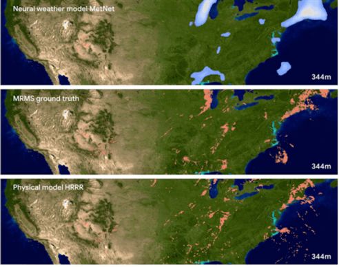
RAPID ADOPTION
Deep learning is being rapidly adopted by the Earth System Science community
Ganapathi Subramanian and Crowley Spatial RL for Fire Dynamics
S. Chen, et al.
A B
C D
E F
Remote Sens. 2018, 10, 1690 18 of 22
G H being weeds or crops. Thus, the center of the extracted image is marked by a colored dot according to
www.nature.com/scientificreports/ www.nature.com/scientificreports the probabilities. Blue, red, and white dots mean, respectively, that the extracted image is identified
as crop, weed, and an uncertain decision (Figure 14a,c). Uncertain decision means that the two
probabilities
Fig. 11. Maps of correlation are very coefficientsclose atto1-km
0.5.resolution
Thereafter,
betweenwe Chlused
(a), Kd crop
(b), SSTline information
(c), SSS and
(d), and surface pCOthe previously created
2, respectively. These correlations were derived
from superpixels
the interannualto classify
monthly all the pixels of the image. On each superpixel, we identify which dot color is
anomalies.
dominant. A superpixel is classed as crop or weed if the majority of dots are blue or red, respectively.
Before locally tuning a RFRE pCO2 model for the G. Maine, we first spatial resolution, it is not practical to include SSS as a predictor.
FIGURE 5 | Results for experiment (B) from all algorithms showing performance on the prediction of the next state For
tested
superpixels
directly
theafter the training data. (A)where
locally parameterized
theMLR
Satellite image majority of dots are white, we used
model proposed by Signorini
crop line information. Hence, superpixels
Signorini et al. (2013) used monthly SSS climatology from the World
of August 11. (B) Thermal image of August 11. (C) Gaussian processes. (D) Value iteration. (E) Policy iteration. (F) Q-learning. (G) MCTS. (H) A3C. Images obtained
from USGS/NASA Landsat Program. et which
al. (2013) are forin thethe crop lines
G. Maine. Similarare regarded
to its as crop
original results, the and
modelthe others are weeds.
Ocean Database (WOD)The2009superpixels created
as a SSS data source in surface pCO2
in their
was found to yield a RMSD of ~42 μatm. Then we tested the RFRE
the background are removed. Figure 14b,d present the classification results in parts of the spinach and resolutions of
model development, but the coarse spatial and temporal
superior results. MCTS was the slowest algorithm we tried since this RL approach model should be(Fig. able to2), learnwhich was parameterized
a reasonable policy in for the GOM, to the G. Maine. this dataset make it difficult to find concurrent and co-located mea-
it is not multithreaded and requires extra roll-out simulations and data-scarce scenarios Poor bean
by focusing
model fields. It can state-action
onperformance
the reachable bewas seenobtained
that inter-row
(RMSD =and intra-row
89.6 μatm), sug- weeds are slightly
surements of SSS foroverdetected.
any given in situ Overdetections
field pCO2 measurements. Fur-
back propagation at every iteration. space only.
There are several reasons why the best RL algorithms are more are
gesting mainly
that the found
effects of at
the the
input edges
variablesoftothe crop
surface pCOrows
2 may where
work the window
thermore, this cannot
area has overlap
relatively the
small whole
river plant.and the corre-
discharge,
Remote Sens. 2020, 12, 901 13 of 19 differently in the G. Maine thannot fromentirely
the GOM.in Because the RFRE-based lation between SSS and surface
suited to such domains than supervised learning algorithms. 8. CHALLENGES Some ANDweed FUTURE pixelsWORK are red because, after applying the threshold to the 2 is poor
pCOExG, the(correlation
parts of coefficient of
The first reason is that, RL can model the spatial dynamics along pCO2 model is empirical and is locally-trained, it can only be applied to ~−0.07 at p < 0.05, based on field measurements). Therefore, even
with time in such domains. This enables RL to predict action As expounded in Malarz theseenvironments.
similar
et plants which
al. (2002), forest fire are less
prediction
Whereas green are RFRE
the GOM-trained considered
model uses soil.
sa- though river discharge-introduced SSS changes (i.e., 25–34) on seasonal
choices using a policy tuned to a particular time of fire spread requires additional information consisting of firefighting inter-
test as compared with supervised learning which estimates a tellite
vention (such as fire SSS
fighting as anand
strategy input to account
time elapsed), whichfor the effect of freshwater mixing, in scale in this region could modulate surface pCO2 variations, SSS may
Figure 5. The results of the whale counting (step-2) CNN-based model that locates and counts the number
model ofbased on inputs and outputs only. The second reason are not taken into consideration in this study, as we choseis
a study
whales (green bounding boxes) in the grid cells in which step-1 CNN gave high probability for whale presence. the G. Maine, because there no relevant satellite SSS available at 1 km not necessarily be an effective predictor for surface pCO2 in the G.
being RL prepares a policy for the agent that takes actions which region having very minimal fire fighting. In future work, we aim
The red bounding box shows a false negative. Map data: Google, DigitalGlobe.
model the underlying causal fire behavior. The supervised learn- to incorporate this kind of information as well as enriching the
ing algorithms do not have such a state-action mapping. Thus model by including more land characteristics such as moisture,
Frontiers in ICT | www.frontiersin.org 10 April 2018 | Volume 5 | Article 6
Figure 6. The proposed automatic whale-counting procedure with a two-step CNN-based model. (A) The
first-step CNN scans the sample area (following the yellow line) to search for the presence of whales in each grid
cell (white squares). Only grid cells in which the first-step CNN gives high probability for whale presence (red
square) are analyzed by (B) the second-step CNN, which finally locates and counts individuals (the four green
(a) (b)
bounding boxes indicate correctly detected whales and the red box indicates a false negative). Map data: Google,
DigitalGlobe.
3
between 0 and 360°, randomly flipping half of the training images, randomly cropping, random the scale size of
the images, and random the brightness level of pixels by a factor of up to 50%.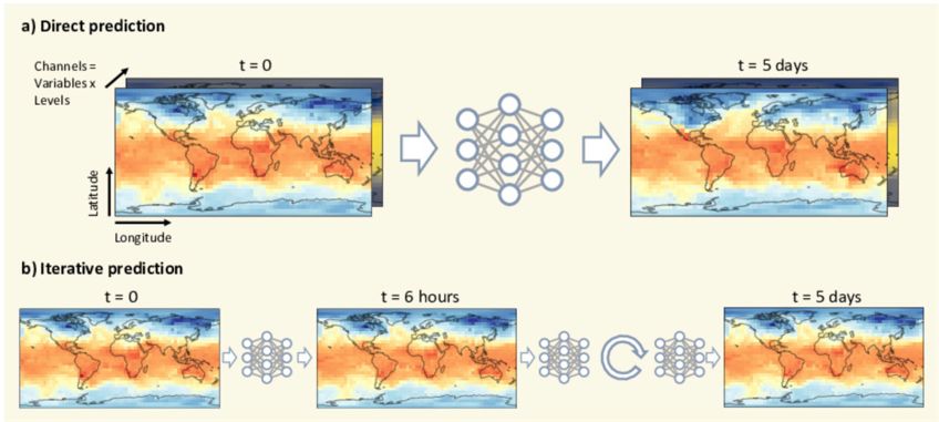
NSF AI INSTITUTES
   Seven new Artificial Intelligence institutes, including one for Weather and Climate

NSF AI Institute for Research on Trustworthy AI in Weather, Climate and Coastal Oceanography

NSF announcement

                                                                                               4
NOAA CENTER FOR AI
Official strategy and dedicated center focusing on AI

  https://nrc.noaa.gov/LinkClick.aspx?fileticket=0I2p2-Gu3rA%3D&tabid=91&portalid=0

                                                                                      5
APPLICATIONS IN
EARTH SYSTEM SCIENCE
                       6
ACCELERATED PHYSICS
       Using surrogate models to speed up existing code

                             EMULATION

  SAMPLES FROM
EXPENSIVE FUNCTION

                                                        FAST
                                                     SURROGATE
                                                       MODEL

                                                                 7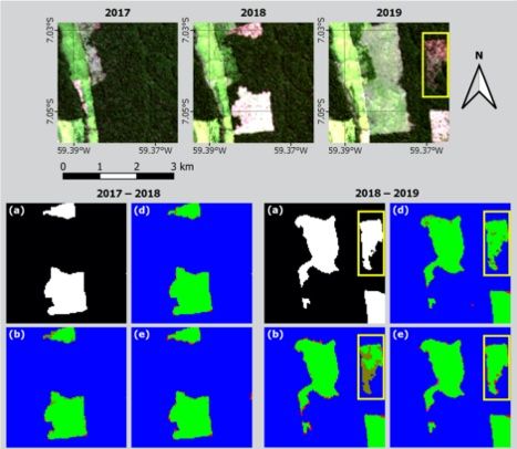
ACCELERATED PHYSICS PARAMETERIZATIONS
                    Emulation of E3SM Super-parameterized SW and LW Radiation

8-10x Speedup in SW and LW Radiative Transfer Calculations

                                                                                8
60
d e
45°
Precipitable water [mm]
IMPROVED PHYSICS PARAMETERIZATIONS 40
Latitude
0°
ARTICLE Building
NATUREmore accurate
COMMUNICATIONS physics parameterizations
| https://doi.org/10.1038/s41467-020-17142-3
https://doi.org/10.1038/s41467-020-17142-3 OPEN 20
Stable machine-learning parameterization
–45° a hi-res b ×8 c ×8-RF
60
of subgrid processes for climate modeling d e
at a range of resolutions 20°
Longitude
50° 20°
Longitude
50° 20° 50°
Longitude
0
45°
Janni Yuval precipitable
& Paul A. O’Gorman 1✉ 1
shots of column-integrated water taken from the statistical equilibrium of simulations. a High-resolution simulation (hi-res),
Precipitable water [mm]
solution simulation (x8), and c coarse-resolution simulation with random forest (RF) parameterization (x8-RF). Insets in a show d a zoomed-in
e the same region but coarse-grained by a factor of 8 to the same grid spacing as in b. The colorbar is saturated in parts of panel b. 40
1234567890():,;
Latitude
Global climate models represent small-scale processes such as convection using subgrid
models known as parameterizations, and these parameterizations contribute substantially to 0°
a Mean precipitation b Extreme precipitation
uncertainty in climate projections. Machine learning of new parameterizations from high-
resolution output is a promising approach, but800
30 modelhi-res hi-res
such parameterizations have been
x8-RF x8-RF
Precipitation [mm day–1]
prone to25 issues of
x8 instability and climate drift, and their performance
x8 for different grid spa-
600 20
cings has not yet been investigated. Here we use a random forest to learn a parameterization
20
from coarse-grained output of a three-dimensional high-resolution idealized atmospheric
model. 15The parameterization leads to stable simulations 400at coarse resolution that replicate –45°
the climate
10 of the high-resolution simulation. Retraining for different coarse-graining factors
200
shows the parameterization performs best at smaller horizontal grid spacings. Our results
5
yield insights into parameterization performance across length scales, and they also
0
demonstrate the potential for learning parameterizations 0from global high-resolution simu- 0
–45° 0° 45° –45° 0° 45°
lations that are now emerging. 20° 50° 20° 50° 20° 50°
Latitude Latitude
Longitude Longitude Longitude
n and extreme precipitation as a function of latitude. a Zonal- and time-mean precipitation and b 99.9th percentile of 3-hourly precipitation,
-resolution simulation (hi-res; blue), and the coarse resolution simulation withFig.
the 1random
Snapshots of parameterization
forest (RF) column-integrated precipitable water taken from the
(x8-RF; orange statistical equilibrium of simulations. a High-resolution sim
https://www.nature.com/articles/s41467-020-17142-3
ted) and without the RF parameterization (x8; green). For hi-res, the precipitation is coarse-grained to the grid spacing of x8 prior to calculating
41 b coarse-resolution simulation (x8), and c coarse-resolution simulation with random forest (RF) parameterization (x8-RF). Insets in a sho
percentile to give a fair comparison .
region and e the same region but coarse-grained by a factor of 8 to the same grid spacing as in b. The colorbar is saturated
9 in parts o
izations both because SAM is not equipped with such outputs in the vertical column together, and therefore the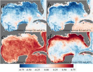
BIAS CORRECTION
Work with ECMWF to remove IFS Model bias

        http://dx.doi.org/10.21957/pl881qs63d   10
NOWCASTING
MetNet: Can beat physical models up to 8 hours
https://ai.googleblog.com/2020/03/a-neural-weather-model-for-eight-hour.html
11MEDIUM-RANGE WEATHER FORECASTING
Weather Bench: A Standardized Benchmark for Data Driven Forecasts
WeatherBench: A benchmark dataset for data-driven weather forecasting
Stephan Rasp, Peter D. Dueben, Sebastian Scher, Jonathan A. Weyn, Soukayna Mouatadid, Nils Thuerey
https://arxiv.org/abs/2002.00469
12MEDIUM-RANGE WEATHER FORECASTING
Data Driven models match accuracy of physical models on weather-bench
13EL NIÑO PREDICTION
Deep learning model able to predict El Niño up to 18 months in advance
https://www.nature.com/articles/s41586-019-1559-7.pdf
14RAPID INTENSIFICATION
Machine Learning improves detection by 40-200 % over operational consensus
Geophysical Research Letters 10.1029/2020GL089102
https://agupubs.onlinelibrary.wiley.com/doi/full/10.1029/2020GL089102
−1
Figure 1. Composite maps of surface precipitation rate (in mm hr ) in storm‐centered coordinate for tropical cyclones in four intensity and four intensification
rate groups (see text for details). The precipitation is from TRMM 3B42 from 1998 to 2014.
15
Wu and Soden (2017). The average IWP within 100 km of storm center is plotted as a function of TC intensityARTICLES
FILLING-IN MISSING CLIMATE OBSERVATIONS https://doi.org/10.1038/s41561-020-0582-5
DL transfer learning + inpainting beats Kriging and PCA
Artificial intelligence reconstructs missing climate
information
ARTICLES Christopher Kadow! !1,2 , David Matthew Hall3 and Uwe Ulbrich! !2
NATURE GEOSCIENCE
Original Historical temperature measurements
(ground truth) Maskedare with
the basis
missingof global
valuesclimate datasets like20crAI
HadCRUT4. This dataset contains many cmipAI reconstruction
reconstruction
a missing values, particularlybfor periods before the mid-twentieth century,calthough recent years are also incomplete. Hered we
demonstrate that artificial intelligence can skilfully fill these observational gaps when combined with numerical climate model
data. We show that recently developed image inpainting techniques perform accurate monthly reconstructions via transfer
learning using either 20CR (Twentieth-Century Reanalysis) or the CMIP5 (Coupled Model Intercomparison Project Phase 5)
Warm experiments. The resulting global annual mean temperature time series exhibit high Pearson correlation coefficients (≥0.9941)
Pacific and low root mean squared errors (≤0.0547!°C) as compared with the original data. These techniques also provide advantages
example relative to state-of-the-art kriging interpolation and principal component analysis-based infilling. When applied to HadCRUT4,
our method restores a missing spatial pattern of the documented El Niño from July 1877. With respect to the global mean tem-
perature time series, a HadCRUT4 reconstruction by our method points to a cooler nineteenth century, a less apparent hiatus in
the twenty-first century, an even warmer 2016 being the warmest year on record and a stronger global trend between 1850 and
20CR 2018 relative to previous estimates. We propose image inpainting as an approach to reconstruct missing climate information
56th e f
and thereby reduce uncertainties and biases in climate records. g h
member
T
Cold he deeper a research period lies in the past, the fewer observa- training based on the output of numerical models (NMs) has been
tions are available. The atmospheric variable with the longest performed on, for example, regional sea surface temperature time
Pacific measurement record is the near-surface air temperature over series in the Baltic Sea14.
example land, usually at a height of 2 m. Around the globe, individual loca- The rapid progress in artificial intelligence (AI) research has sub-
tions have temperature records from as early as the late seventeenth stantially impacted many scientific fields, which includes climate
century1 (for example, Zurich, Prague and Berlin). These records science15,16. Examples include deep learning for the recognition of
are extremely valuable for science2, but these locations are too sparse forced climate patterns17 or extreme events18, ensemble learning
5 × 5° (remap)toAnomalies
derive global(61–90)
or even regional statements.Input for AIs
Station-combining Output composition
using bootstrap aggregation to improve decadal climate predic- Output composition
datasets, which include measurements of sea surface temperature tions and estimating ocean heat content from tidal magnetic satel-
19
by ships, start in the mid-nineteenth century. The Fifth Assessment lite observations using neural networks20, to name a few. Recently,
Fig. 1 | AI models reconstruct two exemplary
Report (AR5) of the United monthly show cases with
Nations Intergovernmental many
Panel on missing
major has beena–h,
progressvalues. madeWarm
in image(September 1877) of(a–d) and cold (August
inpainting, the process
1893) (e–h) eastern PacificClimate Change (IPCC)
examples explainChapter 2 investigates three
the reconstruction
3
pathway reconstructing
of thoseof the held-outmissing parts of images,
56th member from which
20CR.has Shown
been applied
are temperature anomalies in 16
‘Global Combined Land and Sea Surface Temperature’ datasets: primarily to photographs and paintings , but also to, for exam-
21
degrees centigrade with HadCRUT4
respect to 4 the 1961–1990
, MLOST climatology.
(Merged Land–Ocean SurfaceThe ground-truth
Temperature) 5 original
ple, satellite data
images of (column
sea surface 1), masked22,23datasets
temperatures with missing values (grey) of
. In particular,SCIENTIFIC CHALLENGES
17SCIENTIFIC CHALLENGES
Problems that arise when applying AI to science
• Data Labelling
• Limited Data
• Enforcing Physical Constraints
• Uncertainty Quantification
• Trustworthiness and Interpretability
• HPC - AI Coupling
• Loss of Dynamic Range
• Data Movement
• Numerical Stability
• Generalization
18DATA LABELLING
How can we get enough labelled data?
Data Fusion Self-Supervised Learning Reinforcement Learning Active Learning
Using one data source Predicting input B from input A Obtaining labels directly from the Using human machine iteration to
as the label for another environment or simulation make labelling easier
19://doi.org/10.5194/gmd-2020-72
https://doi.org/10.5194/gmd-2020-72
Preprint. Discussion started: 9 April 2020
rint. Discussion started:c 9Author(s)
April2020. 2020
CC BY 4.0 License.
uthor(s) 2020. CC BY 4.0 License.
DATA LABELLING
Online Extreme-Weather Labelling Tool
https://doi.org/10.5194/gmd-2020-72
Preprint. Discussion started: 9 April 2020
c Author(s) 2020. CC BY 4.0 License.
ClimateNet: an expert-labelled open dataset and Deep Learning
architecture for enabling high-precision analyses of extreme weather
Prabhat1,2,* , Karthik Kashinath1,* , Mayur Mudigonda1,10,* , Sol Kim2 , Lukas Kapp-Schwoerer3 ,
Andre Graubner3 , Ege Karaismailoglu3 , Leo von Kleist3 , Thorsten Kurth4 , Annette Greiner1 ,
Kevin Yang2 , Colby Lewis2 , Jiayi Chen2 , Andrew Lou2 , Sathyavat Chandran5 , Ben Toms6 ,
Will Chapman7 , Katherine Dagon8 , Christine A. Shields8 , Travis O’Brien9,1 , Michael Wehner1 , and
William Collins1,2
*
Equal contributions
1
Lawrence Berkeley National Laboratory, Berkeley, CA, USA
2
University of California, Berkeley, CA, USA
3
ETH Zurich, Switzerland
4
NVIDIA, Santa Clara, CA, USA
5
Rice University, Houston, TX, USA
6
Colorado State University, Fort Collins, CO, USA
7
Scripps Institution of Oceanography, University of California, San Diego, La Jolla, CA, USA
8
National Center for Atmospheric Research, Boulder, CO, USA
9
Indiana University, Bloomington, IN, USA
10
Terrafuse, Berkeley, CA,USA
Correspondence to: Karthik Kashinath (kkashinath@lbl.gov)
https://gmd.copernicus.org/preprints/gmd-2020-72/gmd-2020-72.pdf
20ENFORCING PHYSICAL CONSTRAINTS
Is the solution physically correct?
Conservation of Mass, Momentum, Energy, Incompressibility, Loss Penalization, Hard Constraints, Projective Methods,
Turbulent Energy Spectra, Translational Invariance Differentiable Programs
21ENFORCING PHYSICAL CONSTRAINTS
Physics Informed Neural Nets
https://maziarraissi.github.io/PINNs/ 22ENFORCING PHYSICAL CONSTRAINTS
NVIDIA SimNet
https://www.youtube.com/watch?v=Oq2Mpi5pF1w
23UNCERTAINTY QUANTIFICATION
How certain is the prediction?
https://www.researchgate.net/figure/Illustration-of-Gaussian-process-regression-in-
one-dimension-for-the-target-test_fig1_327613136 24UNCERTAINTY QUANTIFICATION
Methods for quantifying uncertainty
https://www.inovex.de/blog/uncertainty-quantification-deep-learning/
25UNCERTAINTY QUANTIFICATION
Methods for quantifying uncertainty
Gaussian process inference Separation of error types
26INTERPRETABILITY
What criteria were used in this prediction?
Layer-wise Relevance Propagation (LRP)
https://lrpserver.hhi.fraunhofer.de/image-classification
27INTERPRETABILITY
Backwards optimization and Layerwise Relevance Propagation applied to ENSO
https://doi.org/10.1029/2019MS002002
28INTERPRETABILITY
LIME: Local interpretable model-agnostic explanations
https://arxiv.org/pdf/1602.04938.pdf
29FORTRAN / AI COUPLING
How can I glue my AI and HPC code together?
+
(Python)
30FORTRAN / AI COUPLING
Many solutions. None ideal.
Use Julia. Call Fortran Use C++ Instead Ok, but limited Missing: Native API Missing: Fortran Bindings
31OVERCOMING LOSS OF DYNAMIC RANGE
Ensemble mean always has less variability than the ensemble members
32OVERCOMING LOSS OF DYNAMIC RANGE
Stochastic Parameterizations
33TRENDS AND
BREAKTHROUGHS
34SELF-SUPERVISION
Babies learn about the world without large labelled datasets. AI can too.
35SELF-SUPERVISION
Pretext tasks build up an internal representation
PREDICT SPATIAL RELATIONSHIPS PREDICT ORIENTATION
PREDICT COLOR
https://arxiv.org/pdf/1806.09594.pdf
PREDICT TEMPORAL ORDER PREDICT MISSING PIECES
36GPT-3
THE TRANSFORMER
175 Billion
Params
Has enabled a series of enormous language models
8.3 Billion
MILLIONS of PARAMETERS
best language papers encoder-decoder-transformers 37GPT-3
(July 2020) Current king of the languages models. Based upon the transformer
38NEW HARDWARE AND
SOFTWARE TOOLS
395 MIRACLES OF A100
NVIDIA Ampere Architecture 3rd Gen Tensor Cores
World’s Largest 7nm chip Faster, Flexible, Easier to use
54B XTORS, HBM2 20x AI Perf with TF32
2.5x HPC Perf
New Sparsity Acceleration New Multi-Instance GPU 3rd Gen NVLINK and NVSWITCH
Harness Sparsity in AI Models Optimal utilization with right sized GPU Efficient Scaling to Enable Super GPU
2x AI Performance 7x Simultaneous Instances per GPU 2X More Bandwidth 40OMNIVERSE
Interactive Raytracing for Data Visualization And Graphical User Interfaces
https://developer.nvidia.com/nvidia-omniverse-platform
41OMNIVERSE
Interactive Raytracing for Data Visualization And Graphical User Interfaces
42PYTORCH LIGHTNING
API to standardize and accelerate your PyTorch models
https://reproducibility-challenge.github.io/neurips2019/resources/ 43PYTORCH-LIGHTNING BOLTS
Lightning implementations of popular models, optimized for GPUs
44Summary
• AI for science is advancing rapidly!
• Good progress on scientific challenges
• Reviewed major trends in AI
• Looked at powerful new hardware and
software tools you can use
dhall@You can also read