FAIRY FEN NATURE RESERVE - MANAGEMENT PLAN ISLANDS TRUST FUND Bowen Island - Bowen Island Conservancy
←
→
Page content transcription
If your browser does not render page correctly, please read the page content below
ISLANDS TRUST FUND
                       Bowen Island

    FAIRY FEN NATURE RESERVE
              MANAGEMENT PLAN

0     1 km

             Whitehead Environmental Consultants Ltd.
                          July 29, 2011

             Adopted by the Islands Trust Fund Board:
                       November 25, 2011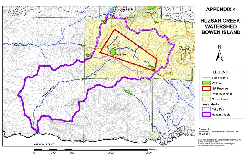
ISLANDS TRUST FUND
               Bowen Island

FAIRY FEN NATURE RESERVE
    MANAGEMENT PLAN

                     Prepared for

                 Islands Trust Fund
         200 – 1627 Fort Street, Victoria, B.C.
                      V8R 1H8

                     Prepared by

     Whitehead Environmental Consultants Ltd.
          P.O. Box 41, Bowen Island, B.C.
                    V0N 1G0

                     29 July 2011

       Adopted by the Islands Trust Fund Board:
                 25 November 2011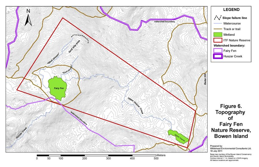
Management Plan: Fairy Fen Nature Reserve, Bowen Island.
Islands Trust Fund. July 29 2011 p.i
Executive Summary
This document presents a m anagement plan for the Islands T rusts Fund’s Fairy Fen Nature
Reserve on Bowen Island. The 18 hectare (44 acr e) property was acquired through the Province
of British Columbia’s Free Crown Grant Program on March 25 th 2010. The main reason for the
establishment of the Reserve was to protect the regionally significant wetland known as Fairy
Fen. The property , which was protec ted in partnership with the Bowen Island Conservancy, is
one of three nature reserves and three covenant areas protected by the Isl ands Trust Fund on
Bowen Island. These protected areas com plement the 397 hectare Ecological Reserve 48,
established by the provincial government in 1973.
The management planning process d ocumented in this report has included identification of the
purpose and management objectives for the Re serve, a compilation of property information, an
ecological inventory, consultation with the public regarding their interest i n and wishes for the
Reserve, and development of an actio n plan covering tasks to be completed in the im mediate
future (18 months to 2 years), as well as short term (3 to 5 years) and long term (5 to 10 years).
The purpose of the Reserve is to preserve the area ’s ecosystems in the ir natural state, in
accordance with the Islands Trust Fund Board’s Five Year Plan (2008-2012) and t he Bowen
Island Official Community Plan. The Reserve’s main management objectives are to:
protect the plant and anim al communities and ecosy stem processes of Fairy Fen and its
headwaters forest in perpetuity;
allow the natural ecological processes and functions to proceed without human interference,
except in the case of wildfire or other situations where remediation is considered imperative;
accommodate the continued low-im pact use of the Reserve for pedestrian visitation, nature
appreciation, education and scientific research;
permit only uses that do not significantly impair the natural condition of the Reserve or its
special features.
The Reserve is located on southwestern flan k of Bowen Island wit hin the Huszar Creek
watershed, spanning an elevation range of 163 m above sea level in the southwest to 239 m in the
northeast. Most of the Reserve is covered in a m ature second-growth coniferous forest of
Western hemlock, Douglas-fir and western redcedar, with smaller areas of mixed forest including
red alder and bigleaf maple. The area was last lo gged in the early to mid 20th century. The last
wildfire in the reserve is thought to have occurred in the late 1920s.
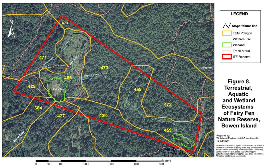
Nine ecosystem types have been documented in the Reserve, belonging to the dry maritime and
very dry maritime units of the Coastal Western Hem lock biogeoclimatic zone. All of these
ecosystems are classified as sensitive by the Islands Trust Fund’s Sensitive Terrestrial Ecosystem
Mapping project. A total of 69 plant and 42 animal species ha ve been iden tified to date in the
Reserve; however, many more are anticipated to be found in the future. Among the species at risk
designated by the provincial and federal governments, only the Red-legged frog ( Rana aurora,
Blue-list) was confirm ed to occur in the Reserve; the Western Screech-Owl ( Megascops
kennicottii kennicottii) and Soot y Grouse (Dendrapagus fuliginosus), both Blue-listed, may
also occur.
Whitehead Environmental Consultants Ltd.
604-947-0144 – alanjw@telus.net
Management Plan: Fairy Fen Nature Reserve, Bowen Island.
Islands Trust Fund. July 29 2011                                                                 p.ii

A total of 1 7 management action items for the Reserve have been identified. These ra nge from
installation of signage and prohibition of access by motorized vehicles, cyclists and horses, and
securing an easement for legal access from Thompson Road in the immediate term; to installing
interpretive signage in th e medium term; and the potential installation of a viewing structure at
Fairy Fen and continuation of biological and ecological inventories in the long term.

It is anticipated that this f irst management plan for Fairy Fen Nature Reserve will be updated in
ten years, in 2021.

                                                                    Whitehead Environmental Consultants Ltd.
                                                                            604-947-0144 – alanjw@telus.net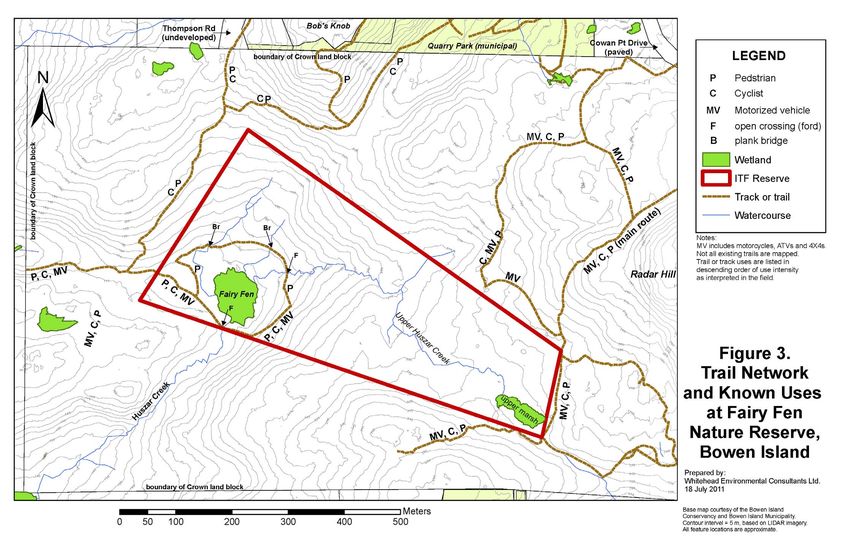
Management Plan: Fairy Fen Nature Reserve, Bowen Island.
Islands Trust Fund. July 29 2011                                                    p.iii

                                   Table of Contents

Executive Summary …………………………………………………………………………….                                         i

Table of Contents ……………………………………………………………………………… iii
List of Figures …………………………………………………………………………………. iv
List of Tables …………………………………………………………………………………..   iv
List of Photos …………………………………………………………………………………..   v
List of Appendices …………………………………………………………………………….. v
Acknowledgements …………………………………………………………………………….. vi

1.0 Introduction ……………………………………………………………………………….                 1
1.1 Islands Trust Fund ………………………… ………………………...…………………….          1
1.2 Islands trust Fund Management Planning ………………………………………………….. 1
1.3 Nature Reserve Purpose ……………………………………………………………………. 2
1.4 Nature Reserve Objectives …………………………………………………………………          2

2.0 Property Information ………………..……………………………….……………………                                  2
2.1 Location ………………..……………………………………………………………………                                         2
2.2 Legal Description ………………..………………………….………………………………                                   4
2.3 Local and Regional Context …………………………………………………………………                                4
2.4 Adjacent Land Use and Connectivity ………………………………………………………..                          4
2.5 Site History ………………………………………………………………………………….                                       8

3.0 Ecological Inventory ………………………………………………………………..……..                                 9
3.1 Climate ……………………………………………………………...………………………                                         9
3.2 Geology and Physiography ………………………………………………………………….                                10
3.3 Soils ………………………………………………………...………………………………                                         11
3.4 Hydrology …………………………………………………………………………………..                                        14
3.5 Ecosystems ………………………………………………………………...………….…….                                     18
3.6 Vegetation ………………………………………………….………………………………                                        19
3.7 Wildlife Species ……………………………………………………………………………                                     22
3.8 Red and Blue Listed Species …………………………………...…………………………                             23
3.9 Red and Blue Listed Plant Communities …………………………………………………                          26
3.10 Invasive Species ………………………………………...………………………………..                                 29

4.0 Stakeholder Consultation ………………………………………………………………..                                29
4.1 Adjacent Landowners ……………………………………………………………………...                                  29
4.2 First Nations Communications ……………………………………………………………..                             29
4.3 Community Members ……………………………………………………………………..                                     30
4.4 Cultural Significance ………………………………………………………………………                                  31

5.0 Management Plan …………………………………………………………………...……. 32
5.1 Discussion topics …………………………………………………………………………... 32
5.2 Public Access ……………………………………………………………………..………… 32
5.3 Trail Use and Location ………………………………………………………….……...…. 32

                                                       Whitehead Environmental Consultants Ltd.
                                                               604-947-0144 – alanjw@telus.net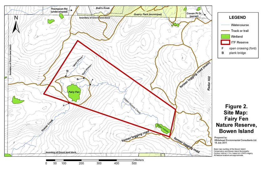
Management Plan: Fairy Fen Nature Reserve, Bowen Island.
Islands Trust Fund. July 29 2011                                                               p.iv

        A Possible Viewing Structure at Fairy Fen ………………………………………….                                33
5.4 Trail Maintenance ……………………………………………………………………….                                                 34
5.5 Permitted Uses …………………………………………………………………………..                                                  34
5.6 Exotic and Invasive Species ……………………………………………………………..                                          34
5.7 Ecological Restoration ………………………………………………………………….                                              34
5.8 Protection of Sensitive Ecosystems and Species at Risk ……………………………….                           35
5.9 Scientific Research and Education ………………………………..……………………...                                    36

6.0 Action Items ……………………………………………………………….…………….                                                   36
6.1 Immediate Actions (within 18 months to 2 years) …………………………….………….                              36
6.2 Short term Actions (within 3 to 5 years) …………………………………………………                                   38
6.3 Long term Actions (within 5 to 10 years) ………………………………………………..                                  38
6.4 Summary Action Item List ………………………………………………….……………                                             38

7.0 Conclusion …………………………………………………………………..…………….                                                    39

8.0 References …………………………………………………………………..……………..                                                  41

Appendices …………………………………………………………...……………………                                                     A-1
Appendix 1. Plant species …………………………………………………..………………                                             A-2
Appendix 2. Wildlife ……………………………………………………….…………… …                                                A-6
Appendix 3. A Brief History of Place Names in Fairy Fen Nature Reserve, Bowen Island ….          A-10
Appendix 4. Summary of responses to the pubic consultation questionnaire ……….………                 A-11
Appendix 5. Watershed Map of Huzsar Creek and Fairy Fen ……………………………..                            A-14
Appendix 6. Copy of Order in Council 166, March 25th 2010, granting the property to
             the Islands Trust Fund. ……………………………………………………….                                      A-16
Appendix 7. Survey Plan of Fairy Fen Nature Reserve ………………………………………                              A-19

List of Figures
Figure 1. Location map of Fairy Fen Nature Reserve, Bowen Island …………………….….…                       3
Figure 2. Site map of Fairy Fen Nature Reserve, Bowen Island ………………………….….…                         6
Figure 3. Trail Network and Known Uses at Fairy Fen Nature Reserve, Bowen Island…….……                7
Figure 4. Average monthly precipitation recorded at Bowen Bay, Bowen Island, 1966 - 1992….           9
Figure 5. Wind speed and prevailing direction at Vancouver UBC Station, 1957 – 1990 ……….            10
Figure 6. Detailed topography of Fairy Fen Nature Reserve, Bowen Island ……………………..                  13
Figure 7. Soils map of South-western Bowen Island including Fairy Fen Nature Reserve ………            11
Figure 8. Terrestrial, Aquatic and Wetland Ecosystems of Fairy Fen Nature Reserve……………              20
Figure 9. Locations of recommended actions or potential improvements in Fairy Fen
          Nature Reserve, Bowen Island ………………………………………………………….                                      41

List of Tables
Table 1. Description of the major soil types reported to occur in the area of
         Fairy Fen Nature Reserve ………………………………………………………..……… 12
Table 2. Descriptions of Islands Trust Sensitive Terrestrial Ecosystem Mapping
         polygons occurring in Fairy Fen Nature Reserve ……………………………………….. 21
Table 3. Number of plant species in the ecosystems of Fairy Fen Nature Reserve ………………. 22
Table 4. Number of wildlife species by major grouping in the forest and wetland
        ecosystems of Fairy Fen Nature Reserve, Bowen Island ………………………………… 22

                                                                  Whitehead Environmental Consultants Ltd.
                                                                          604-947-0144 – alanjw@telus.net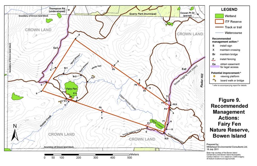
Management Plan: Fairy Fen Nature Reserve, Bowen Island.
Islands Trust Fund. July 29 2011                                                                p.v

Table 5. Red- and Blue-listed Plant Communities existing or potentially present
         in Fairy Fen Nature Reserve, Bowen Island …………………………………………….. 27
Table 6. Conservation Framework Action Groups for species and ecosystems
         in British Columbia ………………………………………….………………………….. 28
Table 7. Invasive plant and animal species confirmed or potentially occurring
         in Fairy Fen Nature Reserve, Bowen Island ……………………………………………. 29

List of Photographs
Photo 1. Springboard logging cuts in a western redcedar stump in Fairy Fen Nature Reserve. …. 8
Photo 2. Charred log from historical wildfire in Fairy Fen Nature Reserve …….………………. 8
Photo 3. Upper Huzsar Creek approx. 150 m from Fairy Fen …………………………………… 14
Photo 4. Lowest reach of upper Huszar Creek as it approaches Fairy Fen ……………………... 14
Photo 5. Confluence of two channels of “West stream” ~120 m from Fairy Fen ……………… 15
Photo 6. “West stream” in an opening of its underground channel beside Fairy Fen …………... 15
Photo 7. Channel of “East stream” ~60 m from Fairy fen, viewed upstream ……………………. 15
Photo 8. Channel of “East stream” within Fairy Fen, near outlet ………………………………... 15
Photo 9. Huszar Creek below Fairy Fen, viewed upstream ……………………………………… 15
Photo 10. Fairy Fen and “West Stream” viewed to north from near fen outlet …………………... 16
Photo 11. Upper marsh, source if upper Huszar Creek …………………………………………… 16
Photo 12. Large puddle in roadway, seasonal source of sediment inputs to inlet of upper marsh … 16
Photo 13. Small seasonal wetland in depression to west of fairy fen, viewed to east ……………… 17
Photo 14. Small forest wetland west of fairy fen, viewed to east ……………………………...….. 17
Photo 15. Mature coniferous forest on the west side of Fairy Fen Nature Reserve ………………. 18
Photo 16. Mature coniferous forest in the southwest sector of Fairy Fen Nature Reserve ……....… 18
Photo 17. Young coniferous forest beside former logging road in the east-central
          area of Fairy Fen Nature Reserve ……………………………………………………… 18
Photo 18. Mixed young forest in the northwest sector of Fairy Fen Nature Reserve ….…….…… 18
Photo 19. Red-legged frog egg mass in East stream within Fairy Fen near the fen outlet ……….. 24
Photo 20. Participants in the field trip to Fairy Fen Nature Reserve during
           the public consultation event on January 23rd, 2011 ………………………………….… 30
Photo 21. Cut logs and ruts due to recreational ATV use on abandoned logging track
          within south-central area of Fairy Fen Nature Reserve ………………………………… 33
Photo 22. Log structure built by recreational ATV users within north-central area
           of Fairy Fen Nature Reserve ……………………………………………………………. 33
Photo 23. Plank bridge (arrow) across West stream near Fairy Fen …………………………….... 33
Photo 24. Heavily disturbed area on the south side of Huszar Creek near the
           Fairy Fen outlet, caused by ATV and motorcycle use ……………………………….... 35

                                                                   Whitehead Environmental Consultants Ltd.
                                                                           604-947-0144 – alanjw@telus.net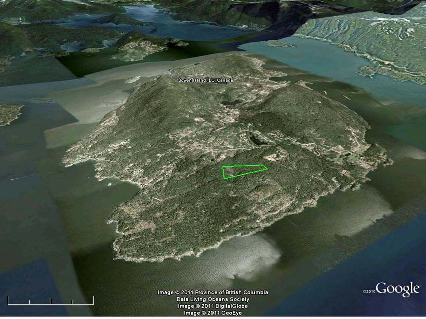
Management Plan: Fairy Fen Nature Reserve, Bowen Island.
Islands Trust Fund. July 29 2011                                                             p.vi

             Acknowledgements

             The Islands Trust Fund Board directs a special thank-you to the
             Bowen Island Conservancy and VanCity Credit Union for their
             financial support, without which Fairy Fen Nature Reserve and
             this management plan would not have been possible.

             The assistance of the following persons and groups in the
             preparation of this m anagement plan is also gratefully
             acknowledged: Peter Drake, Everhard Van Lidth de Jeude and
             Owen Plowman of the Bowen Is land Conservancy; Jeff Ralph,
             Natalie Tamosiunas, Nuala Mur phy and Mark V an Bakel of the
             Islands Trust Fund; Martin Ha rrichhausen of Arbutus Land
             Surveying Inc.; Wil Hilsen of the Bowen Island Municip ality;
             and the many Bowen Islanders and other guests who participated
             in the public consultation. The   report was written by Alan
             Whitehead, M.Sc., R.P.Bio.

                                                                Whitehead Environmental Consultants Ltd.
                                                                        604-947-0144 – alanjw@telus.net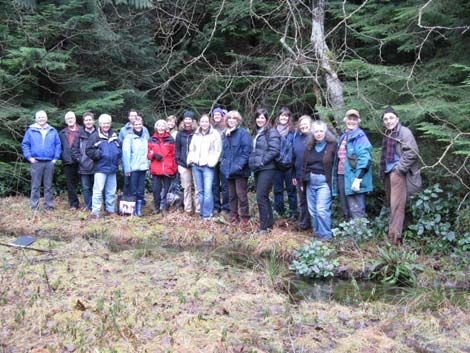
Management Plan: Fairy Fen Nature Reserve, Bowen Island.
Islands Trust Fund. July 29 2011                                                                                      p.1

1.0 Introduction

This document presents a management plan for the Islands Trusts Fund’s Fairy Fen Nature
Reserve on Bowen Island. The 18 hectare (44     acre) property was acquired through the
Province of British Columbia’s Free Crown Grant Program on March 25th 2010.1

The Reserve lies in the headwaters of the      Huszar Creek watershed and contains the
regionally significant wetland known as Fairy Fen. The property was protected in partnership
with the Bowen Island Conserva ncy and is one of three nature reserves and three covenant
areas protected by the Isla nds Trust Fund on Bowen Is        land. These protected areas
complement Bowen Island’s 397 hectare (981 acre) Ecological Reserve 48, established by
the provincial government in 1973.

1.1 Islands Trust Fund

The Islands Trust Fund (ITF) was established in 1990 as a regional conservation land trust
for the Islands Trust area. The Islands Trus t Fund currently owns and m anages 20 nature
reserves and holds over 60 conservation cove nants, permanently protecting over 1,000
hectares of land in the Gulf and Howe Sound Islands.

The ITF “ envisions the islands and waters of the Strait of Georgia and Howe Sound as a
vibrant tapestry of culture and ecology where humans live and work in harmony with the
natural world. This special place has a network of protected areas that preserve in perpetuity
the native species and natural systems of the islands. Engaged residents and conservation
partners work together to protect large natural areas and key wildlife habitat.” (ITF 2010a).

The administration of Islands Trust Fund is pr ovided by the Islands Trust. The Islands Trust
is a unique federation of independent        local governments, including Bowen Island
Municipality, which plans land use and regulates development in the trust area. The object of
the Islands Trust's mandate is “ to preserve and protect the Trust Area and its unique
amenities and environment for the benefit of the residents of the Trust Area and of British
Columbia generally, in cooperation with municipalities, regional districts, improvement
districts, other persons and organizations and the government of British Columbia” (Islands
Trust Act).

1.2 Islands Trust Fund Management Planning

The ITF works to achieve their vision by helping islanders to acquire and protect co re
conservation areas2 that have high biodiversity va lues. Guided by the ITF’s Regional

1
  A copy of the Order in Council granting the property to the Islands Trust Fund is included in Appendix 6.
2
  Core conservation areas include lands with formal/legal conservation status such as: ecological reserves, nature reserves/
sanctuaries held by conservation organizations, parks held for the purpose of protecting natural features (i.e., not including
sports fields and recreational areas), watershed protection lands, conservation covenant lands, etc. They do not include
undesignated Crown Lands or areas protected through land use planning tools like Environmental Development Permit
Areas. (ITF 2010a)

                                                                                        Whitehead Environmental Consultants Ltd.
                                                                                                604-947-0144 – alanjw@telus.net
Management Plan: Fairy Fen Nature Reserve, Bowen Island.
Islands Trust Fund. July 29 2011 p.2
Conservation Plan 2011 – 2015 (ITF 2010a), these areas are evaluated, m anaged and
monitored to preserve their natural featur es. Management plans for each prop erty are
typically developed within one year of its acquisition and updated every five to ten years.
The purpose of a management plan for an ITF nature reserve is to provide long term direction
regarding allowable public use, risks to public safety, ecological values and other significant
features. The Islands T rust Fund Board Five -Year Plan (2008 – 2012) requires that the
following matters are identified and acted upon:
purpose and objectives for the site;
background information including the site history and local and regional context;
environmental inventory;
management issues such as the extent and nature of protection required, appropriate
uses and level of use, research guidelines, risk management, special needs at the site;
strategies and actions to achieve the purpose and objectives for the site and to address
management issues and needs; and
traditional use.
1.3 Nature Reserve Purpose
The purpose of establishing the Fairy Fen Nature Reserve is to:
preserve and protect the natural values of Fairy Fen and its watershed;
allow natural succession of the Reserve’s ecosystems to occur unimpeded; and
protect the site in accordance with the objectives of the Islands Trust, Islands Trus t
Fund and Bowen Island Municipality.
1.4 Nature Reserve Objectives
The Islands Trust Fund objectives for the management of Fairy Fen Nature Reserve are to:
preserve the natural features and functions of the site;
protect and, where necessary, restore the plant and animal communities and
ecological processes at the site;
accommodate the continued low-impact use of the Reserve for pedestrian visitation,
nature appreciation, education and scientific research;
permit only uses that do not significantly impair the natural condition of the Reserve
or its special features; and
allow the natural ecological processes and functions to proceed without human
intervention, except in the case of wildfire or other exceptional situations where
remediation is considered imperative.
2.0 Property Information
2.1 Location
Fairy Fen Nature Reserve is located on Bowen Island, Howe Sound, British Columbia, on the
southwest side of a mountain known locally as Radar Hill (Figure 1). The geographic coor-
Whitehead Environmental Consultants Ltd.
604-947-0144 – alanjw@telus.netManagement Plan: Fairy Fen Nature Reserve, Bowen Island.
Islands Trust Fund. July 29, 2011 p.3
Whitehead Environmental Consultants Ltd.
604-947-0144 – alanjw@telus.netManagement Plan: Fairy Fen Nature Reserve, Bowen Island.
Islands Trust Fund. July 29, 2011 p.4
dinates at the centre of th e property are 49.345° North and 123.399° West (UTM Zone 10N:
Easting 471025, Northing 5465910).
2.2 Legal Description
The legal description of the property is Dist rict Lot 8142, New Westminster District, Bowen
Island (BCGS 92G.034). The lot was created within a block of unsurveyed Crown land
specifically for the purpose of establishing this nature reserve. The parcel was surveyed on
March 26th 2009 by Martin Harrichhausen, BCLS, of Arbutus Land Surveying Inc., Gibsons,
B.C. A copy of the legal survey plan for the property is included in Appendix 7.
2.3 Local and Regional Context
The Reserve is located within the Bowen Island Municipality, the Greater Vancouver
Regional District (GVRD, also known as MetroVancouver) and the Islands Trust.
Bowen Island is access ed by ferry from Horseshoe Bay, West Vancouv er. The Res erve is
accessible from the end of Thompson Road and from an unnamed former logging road off
Cowan Point Drive (Figure 1).
Fairy Fen Nature Reserve lies within the watershed of Huszar Creek, which drains south to
Georgia Strait at the entrance of Howe Sound. The Reserve encompasses the headwaters of
Huszar Creek, including two wetlands (Figure 2).3
2.4 Adjacent Land Use and Connectivity
The Reserve lies within an area of undevelope d mature second-growth forest (cover photo).
Logging and, to a m uch lesser extent, hunting ha ve been the m ain historical land uses
(Howard 1973). Logging is thought to have star ted in the early 1900s and ended possibly as
recently as the 1960s. Hunting was ongoing until as recently as 2001. The summit and upper
northeast part of Radar Hill, approximately 400 to 600 m to the east of the Reserve, contains
a number of Crown tenures (leases), used for communications infrastructure (radio, radar,
microwave), a water tank and, since 2006, a rock quarry. These leases all lie outside of the
Huszar Creek watershed.
Present land uses within the Reserve and in the contiguous lands are lim ited to recreation,
including hiking and, increasingly since approximately 2005, mountain biking, motorcycling
and off-road driving (A TV and 4x4) 4,5. Firewood extraction is also known to occur in the
Crown lands; however this use has not been documented within the Reserve lands.
3
The location of Fairy Fen Nature Reserve within the Huzsar Creek watershed is shown in Appendix 5.
4
ATV = all terrain vehicle; 4x4 = four-wheel drive vehicle; together with trail motorcycles, these are collectively referred to
as off-road vehicles and their use as “off-roading.”
5
We have been unable to confirm whether or not some of the cycling trails in the surrounding Crown land block have been
created or maintained as part of commercial recreational enterprise.
Whitehead Environmental Consultants Ltd.
604-947-0144 – alanjw@telus.netManagement Plan: Fairy Fen Nature Reserve, Bowen Island.
Islands Trust Fund. July 29, 2011 p.5
Built infrastructure within the Reserve and adjacent Crown land is limited to the remains of a
road network, presumably created or last expa nded during periods of logging in the m id-20th
century. The known uses of the existing road and trail network that has been mapped to date
are indicated in Figure 3.
The only trail access to the Reserve lands, as recently as 1995, was an abandoned logging
track from Radar Hill (Figure 3). Additional trails have, by and large, all becom e established
incidentally (i.e., without actual construction) through the effect s of repeated pedestrian and
vehicular traffic. However, m ountain biking and off-roading enthusiast s have been creating
new routes through m uch of the Radar Hill ar ea including lands that are now within the
Reserve. In some places, plank bridges have been built for cycling or trees have been cut and
logs placed to facilitate passage of ATVs and 4x4s.
Whitehead Environmental Consultants Ltd.
604-947-0144 – alanjw@telus.netManagement Plan: Fairy Fen Nature Reserve, Bowen Island.
Islands Trust Fund. July 29, 2011 p.6
Whitehead Environmental Consultants Ltd.
604-947-0144 – alanjw@telus.netManagement Plan: Fairy Fen Nature Reserve, Bowen Island.
Islands Trust Fund. July 29, 2011 p.7
Whitehead Environmental Consultants Ltd.
604-947-0144 – alanjw@telus.netManagement Plan: Fairy Fen Nature Reserve, Bowen Island.
Islands Trust Fund. July 29, 2011 p.8
2.5 Site History
Bowen Island lies within the traditional territory of the Squamish First Nation. The history of
the lands in and around Fairy Fen Nature Reserve is largely undocum ented. Presumably, the
site was known to aboriginal peoples long before the arrival
of the Europeans and their descendants in the late 19 th
century (Howard 1973). The cl osest known archaeological
sites to the Reserve are shell middens located at Arbutus Bay
and Tunstall Bay; no inland sites have been recorded (Hall
2006). No culturally m odified trees or other archaeological
remains in the Reserve and the surrounding C rown lands
were observed during the preparation of this m anagement
plan.
The Reserve area contains numerous tree stumps showing the
characteristic spring-board cuts (Photo 1), which are
evidence of historical logging in the late 1800s and early
1900s before the advent of the chain-saw. Similarly, som e
areas on the east side of the Reserve also co ntain shorter Photo 1. Springboard logging cuts in a
stumps that confirm the presence of chain-saw based logging western redcedar stump in Fairy Fen
Nature Reserve. 110426
in the mid-20th Century.6
Forest fires are known to have occurred on Bowen Island in
the early p art of the 20 th century. Severa l of the older
Douglas-fir trees and standing dead trunks show evidence of
fire (Photo 2). The BC Ministry of Forests reco rds indicate
that there have been no major wild fires on Bowen Island
since at least 1950, the earliest year for which formal records
are available (Rob Crookshank, Ministry of Forests, personal
communication).
Hunting for deer and, possibly, grouse, is also known to have
taken place. Although grouse hunting has not taken place fo r
decades, deer hunting on Crown land continued until
approximately 2000, w hen hunting on public lands was Photo 2. Charred stump from
prohibited by the recently formed municipal government.7 historical (ca. 1920s) wildfire in
Fairy Fen Nature Reserve. 070107
In the late 1980s and early 1990s, the m ain wetland, now known as Fairy Fen, was identified
as the preferred site for the creation of a wate r reservoir to s erve a proposed residential and
golf course developm ent on the Cape Roger Cu rtis lands to the west (Busb y Bridger
Architects 1992). The proposed re servoir design included the c onstruction of two dams, one
on the west and the other on the southwest side of the fen to create a large impoundment that
6
BC Ministry of Forests online records indicating the last known commercial logging under permit on Bowen Island were
not located.
7
Hunting on Bowen Island is only allowed on private property with the owner’s permission, and only using simple long
bows (Bowen Island Municipality Bylaw No. 21, 2000).
Whitehead Environmental Consultants Ltd.
604-947-0144 – alanjw@telus.netManagement Plan: Fairy Fen Nature Reserve, Bowen Island.
Islands Trust Fund. July 29, 2011 p.9
would have flooded the fen. This proposal was later discontinued when the Busby project
was withdrawn.
Recreational and conservation interests in the area have aris en out of increasing visitation by
naturalists in the early 1990s and, more recent ly, active use of the area by m ountain bikers
and off-road vehicle enthusiasts.
The regional importance of the m ain wetland in the Reserve was highlighted in th e Bowen
Island Wetland Inventory, prepared for the Bowen Island Conservancy with support from the
Islands Trust Fund (Golinski 2002). The descri ption in that report, which included the
statement that Fairy Fen “should probably be protected as an Ecological Reserve,” strongly
bolstered the efforts of the island’s naturalist community to achieve the permanent protection
of the wetland and its surrounding forest.8
Mountain biking and off-roading b egan in the early 2000s and, with the growing popularity
of vehicle-centred outdoor recreation, has been increasing throughout Bowen I sland on
undeveloped private parcels and Crown lands.
3.0 Ecological Inventory
3.1 Climate
The climate in the Reserve is typical of the southwest flank of Bowen Is land. Precipitation
averages 1506 mm per year, of w hich approximately 3.3% falls as snow (Environm ent
Canada 1994; based on records from Bowen Bay, 1966 to 1992). The site is m oderately
exposed to the south-easterly and westerly wind s from the Strait of Georgia, which tend to
bring the strongest storms and precipitation (Environment Canada 1994, Lange 1998), and is
sheltered from the northerly and easterly winds. Precipitation data for Bowen Ba y9 from
1966 to 1992 are shown in Figure 4.
250
Average Annual Precipitation = 1505.9 mm.
200
Figure 4. Average
monthly precipitation
150
recorded at Bowen Bay,
mm
Bowen Island, 1966 -
100
1992. (Environment
Canada 1994)
50
0
Jan Feb Mar Apr May Jun Jul Aug Sep Oct Nov Dec
Air temperatures average
8
A brief history of place names in the Reserve is provided in Appendix 3.
9
Bowen Bay is located approximately 3.3 km NW of Fairy Fen.
Whitehead Environmental Consultants Ltd.
604-947-0144 – alanjw@telus.netManagement Plan: Fairy Fen Nature Reserve, Bowen Island.
Islands Trust Fund. July 29, 2011 p.10
around 10º C annually; summe rs are generally cool and hot periods short-lived; winters are
typically cold with infrequent period s of freezing weather, the latter us ually associated with
Arctic outflow winds in Howe Sound. Tem perature extremes recorded in the region reach
33.3º C in July and August and -17.8º C in December and January (Taylor & Langlois 2000).
The closest weather station with wind data is UBC at Point Grey (Environm ent Canada
1994). The most commonly occurring wind directio n is easterly from October through May,
south-easterly from June through August, and north-westerly in September, with wind speeds
usually less than 7 km/h. The strongest winds tend to occur during the fall through spring; the
highest hourly wind speeds range between appr oximately 23 km /h in August and 32 to 40
km/h in October through March.
Figure 5. Wind speed and prevailing direction at Vancouver UBC Station,
1957 – 1990. (Environment Canada 1994)
Maximum Hourly Speed
Most frequent speed
45
SE
40 SE
N
SE
35 SE SE SE
SE
30 E NW SE
25 E
km/h
20
15
E E
10 E E SE SE NW E E E
E SE
5
0
Nov
Oct
Apr
May
Feb
Aug
Sep
Dec
Mar
Jan
Jun
Jul
3.2 Geology and Physiography
The subsurface geology on Bowen Island con sists of Coast Plutonic ho rnblende diorite and
granodiorite which has intruded into a thick asse mblage of altered volcanic rocks and m inor
interbedded sediments of the B owen Island Group (Roddick 1965, Maynard 1979,
Armstrong 1990). Exposed bedro ck surfaces, where visible, tend to be sm ooth and rounded
by glaciation. Within the Reserve, bedrock outcrops occur in places; however, they tend to be
relatively small (Management Plan: Fairy Fen Nature Reserve, Bowen Island.
Islands Trust Fund. July 29, 2011 p.11
to 163 masl at the outlet of Fairy Fen. The detailed topogr aphy of the Reserve, based on a 1-
m elevation contour interval, is shown in Figure 6.
The hillside to the north of Fairy Fen appears to be an area of slope failure and land slippage,
which has formed a horseshoe-shaped depression marked by an abrupt slope chang e at the
upper edge and seepage-fed watercourses along the sides (Figure 6).
3.3 Soils
Figure 7 shows the distribution of soils on southwest Bowen Island, as m apped by the
Provincial government (Luttmerding 1980, 1981). So ils in the area of the Reserve are
described as a com plex consisting of two so il classes plus exposed bedrock. The wetland
soils are not identified in that survey due to the broad scale of mapping.
Figure 7. Soils map of South-western Bowen Island
(adapted from Luttmerding 1980)
Fairy Fen
Nature Reserve
The predominant soil type is a complex of Bose, Cannel and bedrock classes (BO-CE-RO).
Bose (BO) soils are described as follows: “S oil bearing capacities for houses and sim ilar
construction are good (varies to m oderate where glaciomarine deposits occur in the subsoil),
however low subsoil perm eability and often strongly sloping topography limit sewage
effluent disposal from septic tanks.”
Cannel (CE) soils are described as: “poorly su ited for urban and othe r construction because
of shallowness to bedrock and steep sl opes. Although foundation conditions are good
because they can be placed directly on bedrock, basements, underground utilities and other
excavations are difficult to install. Septic tanks are unsuitable because of lack of soil depth
Whitehead Environmental Consultants Ltd.
604-947-0144 – alanjw@telus.netManagement Plan: Fairy Fen Nature Reserve, Bowen Island.
Islands Trust Fund. July 29, 2011 p.12
for effluent disposal, and steep slopes. Road s are difficult and expens ive to co nstruct.”
(Luttmerding 1981).
Table 1 provides additional descriptions of these soil classes.
Table 1. Description of the major soil types reported to occur in the area of Fairy Fen Nature
Reserve. (after Luttmerding 1980, 1981)
Soil Name Material Drainage and water retention Soil
(map symbol) Classification
Bose Gravelly sandy loam or Well to moderately-well drained; low Duric, Ferro-
(BO) gravelly sandy loam at water-holding capacity; rapidly Humic Podzol
surface. 130 to 160 cm of pervious in the upper, gravelly layers,
moderately to very stony slowly pervious in the compacted
gravelly lag or glaciofluvial underlay; lateral seepage along top of
deposits over moderately compacted subsoil is common after
coarse-textured glacial till and prolonged, heavy rain.
some moderately fine-
textured glaciomarine
deposits.
Cannell Sandy loam or gravelly loam; Well to rapidly drained; low to Orthic Humo-
(CE) moderately to exceedingly moderate water holding capacity; Ferric Podzol
stony. 10 to 100 cm of rapidly pervious; lateral seepage along
moderately coarse-textured surface of underlying bedrock where
glacial till or colluvium over latter is unfractured
bedrock (usually granitic)
Rock Areas of bedrock exposed or Rapidly drained; no moisture holding n.a.
Outcrop with less than 10 cm of capacity; impervious; fast surface
organic or mineral soils on runoff.
(RO) the surface.
The wetland soils within Fairy Fen consist of a deep deposit of peat in excess of 3 m deep.
Soils in the other wetlands of the Reserve have not been characterized to date.
Whitehead Environmental Consultants Ltd.
604-947-0144 – alanjw@telus.netManagement Plan: Fairy Fen Nature Reserve, Bowen Island.
Islands Trust Fund. July 29, 2011 p.13
Whitehead Environmental Consultants Ltd.
604-947-0144 – alanjw@telus.netManagement Plan: Fairy Fen Nature Reserve, Bowen Island.
Islands Trust Fund. July 29, 2011 p.14
3.4 Hydrology
Fairy Fen Nature Reserve is situated within the upper headwaters of Huszar Creek (Appendix
5). The watershed of Huszar Creek covers approxim ately 128 hectares (ha), of w hich the
catchment area of Fairy Fen is approximately 50 ha or 39%. The 18.3 ha encompassed within
the Fairy Fen Nature Reserve occup ies approximately 37% of the Fairy Fen watershed and
14% of the Huszar Creek watershed. W ater bodies within the Reserve include several small
streams and two main wetlands.
Streams
Fairy Fen is fed by three separate streams, all of which
are seasonal (Figure 2). Upper Huszar Creek (P hoto 3)
originates at the upper m arsh and flows over a distance
of approximately 685 m to Fairy Fen. Upper Huszar
Creek has three reaches, defined for present purposes on
the basis of channel gradient. The upper reach is gently
sloping and the channel tends to be poorly defined and
meandering; the bank-full width is usually ~1 m but can
reach up to 3 m in places; wa ter depth is typ ically less
than 10 cm , except in o ccasional pools formed behind
individual logs and small de bris jams. The channel in
the middle reach, which is steep er, is confined in the
bottom of a small, V-shaped ravine approximately 3 to 4
m deep; the bank-full width seldo m exceeds 1 m and
water depth is typically less than 10 c m, except in
Photo 3. Upper Huzsar Creek
occasional pools. A small tributary joins the lower end approx. 150 m from Fairy Fen,
of this m iddle reach f rom the northeas t. The lowest viewed downstream. 110513
reach is gently sloping as it app roaches Fairy Fen;
in this area, the channel again becom es poorly
defined (Photo 4), with m eanders and
distributaries being com mon. The bank-full width
is typically ~1 m but can reach up to 2 m in places;
water depth is usu ally less tha n 10 cm , except in
occasional pools.
The two other watercourses, which are m uch
smaller, originate on e ither side of the land-s lip
area to the north of F airy Fen (F igure 2). F or
present purposes, th ey are called “West Stream ” Photo 4. Lowest reach of upper Huszar Creek as it
and “East Stream”. Both are fed by seepage fro m approaches Fairy Fen, viewed downstream.
the land slippage area and runoff from the adjacent
forest. West Stream (Photos 5,6) is approxim ately 315 m long and East Stream is
approximately 140 m long. Both have a steeper upper reach and a flatter lower reach. The
upper reach flows in well defined channels up to 0.5 m wide, with water depth seldom
exceeding 10 cm except in occas ional drop pools. Once these streams enter the flatter area
Whitehead Environmental Consultants Ltd.
604-947-0144 – alanjw@telus.netManagement Plan: Fairy Fen Nature Reserve, Bowen Island.
Islands Trust Fund. July 29, 2011 p.15
Photo 5. Confluence of two channels of “West Photo 6. “West stream” in an opening of its
stream” ~120 m from Fairy Fen. 110426 underground channel beside Fairy Fen.101116
beside Fairy Fen, the channels becom e less well defined. The lower ~ 140 m of West stream
is mostly underground, threading through the fo rest floor, following an arc that u ltimately
enters the fen from the west side (Figure 7). In contrast, East Stream (Photos 7, 8) follows a
more perpendicular route into the fen; however, in the f lattest terrain near the f en, it forms
several distributaries in the forest floor and within the outer edge of the fen.
Photo 7. Channel of “East stream” ~60 m from Fairy Photo 8. Channel of “East stream” within Fairy Fen,
fen, viewed upstream. Note plank bridge. 110426 near outlet, viewed upstream. 101102
The Reserve also inclu des a sho rt segment of
lower Huszar Creek (~15 m) where this s tream
forms the outlet of Fairy Fen (Photo 9). Lower
Huszar Creek contains flow alm ost year-round,
except in late summ er and early fall after
prolonged periods of dry weather. The channel
lies within a small floodplain up to ~10 m wide;
bank-full width ranges be tween approximately
1.5 and 3 m, and the water depth is comm only
over 20 cm.
Photo 9. Huszar Creek below Fairy Fen, viewed
upstream. Channel width ~2 m.
Whitehead Environmental Consultants Ltd.
604-947-0144 – alanjw@telus.netManagement Plan: Fairy Fen Nature Reserve, Bowen Island.
Islands Trust Fund. July 29, 2011 p.16
Wetlands
The Reserve contains two main wetlands: its namesake Fairy Fen at the west (lower) end and
a small marsh at the east (upper) end. For present purposes, this m arsh is referred to as
“upper marsh” (Figure 2).
Fairy Fen (Photo 10) is broadly oval-shaped with
dimensions of approxim ately 70 m east-to-west
and 97 m north-to-south, and a su rface area of
approximately 0.54 ha (1.3 acres). Its surface
water sources have been described above. Within
the fen its elf, “West stream” and “East stream ”
present as distinct watercourses, approximately 65
m and 50 m long, resp ectively, around the
wetland’s perimeter. The channels of these
streams within the fen are vertically-sided,
Photo 10. Fairy Fen and “West Stream” viewed to
approximately 0.4 to 0.7 m wide, and up to 0.6 m north (upstream) from near fen outlet. 101102
deep. The two stream s join near the outle t into
one channel within the fen, approxim ately 8 m
long, forming the upperm ost part of Husz ar
Creek.
Upper marsh (Photo 11) is an elongated wetland,
measuring approximately 95 m long by 25 m
wide and a surface area of approximately 0.21 ha
(0.5 acre). Surface water inputs are m ainly the
runoff from the road ad jacent road on Radar Hill,
which can be heavily laden with sedim ent when
rainy weather coincides with veh icular traffic 070401
(Photo 12). The outle t of this marsh is the o rigin
Photo 11. Upper marsh, source if upper Huszar
of upper Huszar Creek. Creek, viewed to west.
110520
Photo 12. Large puddle in roadway, seasonal
source of sediment inputs to inlet of upper marsh.
Whitehead Environmental Consultants Ltd.
604-947-0144 – alanjw@telus.netManagement Plan: Fairy Fen Nature Reserve, Bowen Island.
Islands Trust Fund. July 29, 2011 p.17
Other minor wetlands a lso exist, particularly in the west co rner of the Reserve, in the flat
terrain immediately west of Fairy Fen (Photos 13 and 14), and in the land slippage area
between East and West streams.
110323 110505
Photo13. Small seasonal wetland in depression to Photo 14. Small forest wetland west of fairy fen,
west of fairy fen, viewed to east. viewed to east. Note disturbance by ATVs in
foreground.
Whitehead Environmental Consultants Ltd.
604-947-0144 – alanjw@telus.netYou can also read