Farm Management Plan - Central Goldfields Shire Council
←
→
Page content transcription
If your browser does not render page correctly, please read the page content below
Page 1 of 36

         Farm Management Plan
          Lot 2 (50 Alma-Moonlight road, Alma)

2077   50 Alma-Moonlight Road, Alma              April 2021
Page 2 of 36

Planning Report for Proposed Lot.2 (50 Alma-Moonlight road, Alma)
Project: 2077
Report prepared by: Julie Lee of Natural Resource Pty Ltd link for the owners

Natural Resource Link
ACN 609 952 025
ABN 83 609 952025
54 Fraser Street, Clunes, Vic, 3370
Ph: 0406 459 522
Email: julie@nrlinks.com.au

 REV    DETAILS      DATE

        FINAL        April 2021

Copyright
Natural Resource Link Pty Ltd shall retain ownership of the reports and drawings, design,
displays and other work produced by Natural Resource Link Pty Ltd during the course of
fulfilling a commission until final payment by the client.

Disclaimer
Natural Resource Link Pty Ltd does not accept any liability for an error, omission or loss or
other consequence that may arise from relying on this report.

2077                  50 Alma-Moonlight Road, Alma                                April 2021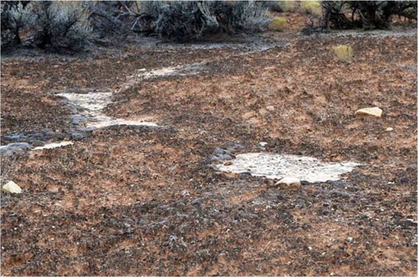
Page 3 of 36

Contents
INTRODUCTION ................................................................................................................................ 4
   PURPOSE .......................................................................................................................................................4
   CATEGORY AND CLASSIFICATION OF LAND ...........................................................................................................4
   OVERLAYS ..................................................................................................................................................... 5
   SITE .............................................................................................................................................................. 5
SOIL TYPE FOR AGRICULTURAL USE ................................................................................................. 6
   AUSTRALIAN SOIL CLASS ..................................................................................................................................6
   LAND SYSTEM ................................................................................................................................................ 7
   LAND FORM ................................................................................................................................................... 7
   TOPOGRAPHY............................................................................................................................................... 10
ECOLOGY AND RISKS ON SITE EXPLAINED ....................................................................................... 11
   CREEKLINE HERB-RICH WOODLAND ................................................................................................................. 12
   ALLUVIAL TERRACES HERB-RICH WOODLAND ................................................................................................... 13
   GRASSY WOODLAND..................................................................................................................................... 14
   EXPLAINING BENCHMARK ............................................................................................................................... 15
FARM MANAGEMENT .......................................................................................................................21
   WEEDS ........................................................................................................................................................ 21
    Environment Protection and Biodiversity Conservation Act ...................................................................... 21
    Flora and Fauna Guarantee Act............................................................................................................... 21
    Catchment and Land Protection Act. ....................................................................................................... 21
           State Prohibited weeds ......................................................................................................................................22
           Regionally controlled weeds ..............................................................................................................................22
           Restricted Weeds ...............................................................................................................................................22
   KEY POINTS FOR ALL LANDOWNERS AND LAND OCCUPIERS ABOUT NOXIOUS WEED AND PEST ANIMAL MANAGEMENT .... 22
     Weeds of National Significance (WONS).................................................................................................. 24
     Methodology .......................................................................................................................................... 25
           Assessment Qualifications and Limitations ........................................................................................................ 25
       Results. .................................................................................................................................................. 25
WEED CONTROL .............................................................................................................................. 26
   WINDBREAKS ............................................................................................................................................... 28
   INCREASE TOPSOIL ........................................................................................................................................ 28
   IRRIGATION .................................................................................................................................................. 28
   REGENERATION-EROSION CONTROL ................................................................................................................ 29
   COMPOSTING ............................................................................................................................................... 29
   INCREASING SOIL CARBON .............................................................................................................................. 30
   OTHER RECOMMENDATIONS ........................................................................................................................... 30
APPENDIX.1. SITE PLAN ................................................................................................................... 31
APPENDIX.2. FARM MANAGEMENT PLAN......................................................................................... 32
APPENDIX.3 EVC 68 ........................................... ............................................................................. 33
APPENDIX.4 WEED LIST ...................................................................................................................34
APPENDIX.5 WINDBREAKS ............................................................................................................... 35
APPENDIX.6 DETAILED INFO ON UNDERSTANDING YOUR SOIL-NCCMA ......................................... 36

2077                                    50 Alma-Moonlight Road, Alma                                                                                 April 2021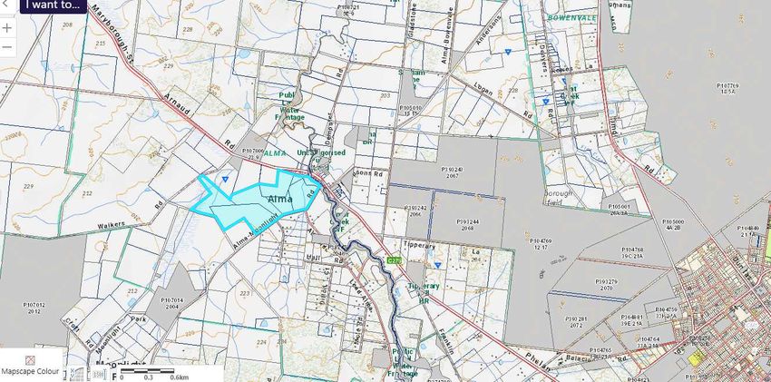
Page 4 of 36

Introduction

This report aims to deal with the need for a land management plan for this site, to advise current
and future owners of their obligations to undertake reviews; and ensure that the site is maintained
to ensure that pest and animals species are controlled on site. This is a requirement of conservation
applications.

Purpose

This plan will demonstrate how the site can be maintained in perpetuity and how existing land
management can be undertaken.

Category and classification of land

The site is zoned Farming Zone and is covered with remnant vegetation to almost 50% of the site.

2077                    50 Alma-Moonlight Road, Alma                                    April 2021
Page 5 of 36

Overlays

The overlay on site is LSIO -Land Subject to Inundation

Erosion management overlay to a small part of the site

Site

The landscape is mostly open rural land with a mix of cropping/grazing, remnant vegetation and
hobby farms. The landscape is flat and is serviced by sealed and all-weather roads and has a mixture
of developed and undeveloped lots.

                                                                           The open landscape has
                                                                           a major watercourse (
                                                                           Timor Creek) and many
                                                                           tributaries; with several
                                                                           small reserves. The
                                                                           Maryborough-St Arnaud
                                                                           is the main highway that

2077                    50 Alma-Moonlight Road, Alma                                   April 2021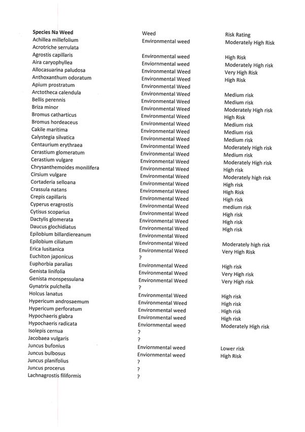
Page 6 of 36

passes the site to the north-east and current access to site is from the Alma-Moonlight road
(unsealed).
The site is in the Goldfields Bioregion and contains a mix of EVC’s on this site.

Soil Type for Agricultural Use

Australian soil class

The Australian soil class for this site is a Sodosol that cover 30% of Australia

(A) Mottled Brown Sodosol
These soils have yellow to brownish yellow coloured upper subsoil horizons that are usually mottled.
The subsoils are usually coarsely structured, and prismatic and/or columnar peds are common. They
are generally specific to mid-range rainfall areas (i.e. 500-800 mm) and commonly occur in the
Uplands regions as well as in the western volcanic plains and southern plains of Victoria. These soils
mainly support dryland sheep grazing and are common in a number of areas of Victoria where gold-
mining has taken place (e.g. central goldfields region). Further information is provided on this soil,
including a case for why it should be considered as the State Soil for Victoria

2077                     50 Alma-Moonlight Road, Alma                                      April 2021

Page 7 of 36

                                                                 Soil profile image of soil on site (left)

Land System

The site is mapped to be 2.1PfQ5-7 which is a duplex soil with the following susceptibilities to land
degradation:

    •   Compaction               High
    •   Leaching                 Moderate
    •   Mass Movement            Nil
    •   Salinisation             Moderate
    •   Water Erosion            Nil
    •   Water logging            Nil
    •   Wind Erosion             Nil

Land Form

2.1.7 Terraces and floodplains (Upper Loddon, Upper Woady Yallock Creek, Pomonal - Moyston
area, Crowlands, Avoca, Newstead)

2. Western Uplands (WU)
2.1 Dissected Uplands

2077                    50 Alma-Moonlight Road, Alma                                        April 2021
Page 8 of 36

Alluvial flats are a common feature in most valley floors.
In some valleys, the majority of the alluvium has been
deposited in episodes of drainage disruption and
blockages during the Late Neogene volcanism. Examples
include the extensive alluvial flats of the Lal Lal Swamp
and Dog Trap Creek. Some minor sandy deposits are
associated with the Lal Lal swamp (lunette).
Soil types present include dark self-mulching clays,
texture contrast soils, some gradational soils and minor
sandy soils.
Alluvial systems within the Dissected Uplands of the
Wimmera CMA region include Mount Cole Creek,
Mount William Creek and the Wimmera River. Mount
Cole Creek, the upper Wimmera River and other minor
tributaries are supplied surface and groundwaters
by Palaeozoic bedrock hilly terrain and Neogene
cappings that line many lower hillslopes. As a tributary
that supplies the Wimmera River, Mount William Creek
rises on the slopes of Mt. William in the Grampians and
flows slowly to the north-west through Dadswells
Bridge. Extensive alluvial plains of this drainage system
represent a low pass (geocol) that separates the
Dissected Uplands (Midlands) to the east from the
Grampians to the west.

These fluviatile alluvia plains are characterised by its effluents and anabranches which leave the
main channels (Sibley 1967). The tributaries are called subsequent streams where streams have
evolved along areas of rock belt weakness leaving folded or titled strata of differing resistance as
prominent strike ridges (Hills 1975). Drainage networks of Mount William Creek, Salt Creek, upper
Wimmera River/Mount Cole Creek and Wattle Creek are aligned in a north north-westerly alignment
with strike ridges on a regular spacing of 10-15 kilometres. Valley flats, terraces and flood out plains
are common with Mount William Creek broadest in cross tributary dimension (often in excess of 5
kilometres) while others are typically less than 2 kilometres. Slopes are gentle to very gently inclined
with terrace slopes of greatest inclination (up to 10%) found along Mount Cole Creek and upper

2077                     50 Alma-Moonlight Road, Alma                                      April 2021

Page 9 of 36

Wimmera River.

The entrenched valleys of Quaternary sediments including the Shepparton Formation (a thick
sequence of unconsolidated fluvial and lacustrine sediments – coarse sand, silt and clay) occur
largely as terraces, plains and drainage lines. Sediments have been derived through differential
weathering of granite masses that are surrounded by ridges and peaks of
resistant metamorphosed sediments. The Coonambidgal Formation (reworked Shepparton
Formation of slightly micaceous silty clay, sand and gravel) occur within drainage lines subject to
flooding and inset streams (Butler 1958, Krokowski de Vickerod, Moore & Cayle 1997).

Flood plains of Mount William Creek are lined by aeolian deposits (sands) sourced from the
Grampians and lined by River Red gums on subdued slopes of this inset stream. The plains and
terraces of the upper reaches of the Wimmera River system around Mount Cole Creek, Concongella
and Elmhurst have been formed by the more rapid weathering of granitic rocks in the area,
accompanied by the deposition of recent alluvial sediments. Incipient weathering profiles of older
fluvial deposits have some mottling reflecting poor site drainage and clay alleviation processes.
Granitic detritus of these valley systems has high concentrations of quartzose sand intermixed with
silts that often compose terraces occupying elevated positions above the current drainage plain.
Soils of the unit are deep grading into the generally unconsolidated regolith. These may range from
texture contrast, generally sodic (Sodosols) to gradational earths and occasional clay
(Vertosols, Dermosols) and sandy soils (Tenosols). Some soils may be waterlogged prone for at least
3 months of the year (Hydrosols).
The texture contrast soils vary between the red non-sodic soils against the brown, yellow and grey
sodic variants. All have sandy loam surfaces overlying a massive conspicuously bleached subsurface
horizon. A clear change exists to light and medium clay subsoils where sodicity and colour are the
distinguishing features. Importantly, the red texture contrast soils are commonly associated with
terraces rather than current alluvial plains. Here most of the gradational yellow and brown soils
(Kandosols) are found.
Remnant vegetation communities are dominated by forests (Heathy Dry Forest and Grassy Forest)
closest to intersection of the Wimmera River downstream of Greens Creek where stream gradients
are low and anabranching is well defined. Woodlands including Damp Sands Herb-rich Woodland,
Plains Grassy Woodland, Creekline Grassy Woodland, Riparian Woodland, Plains Woodland, Grassy
Woodland occur along Mount William Creek with Lateritic Woodland, Sand Heathland, Sand Forest,
Red Gum Wetland and Sedge Wetland found on floodplains and flats away from the current
drainage depression.

2077                     50 Alma-Moonlight Road, Alma                                    April 2021
Page 10 of 36

Heathy Dry Forest and Grassy Forest vegetation communities are associated with exposed areas of
the alluvial plains of the Upper Wimmera River and Mount Cole Creek while Herb-rich Foothill Forest
and Valley Grassy Forest are more associated with sheltered areas higher in the catchment. Various
woodlands including Alluvial Terraces Herb-rich Woodland also occur across these valleys. Dry
woodlands dominate drainage of Six Mile Creek/Seven Mile Creek and Salt Creek.
The alluvial plains often compose later derived sediments that overlie gravels and sands of these
valley deposits. Large volumes of groundwater are attributed to these alluvial systems through
contributions of Grampians colluvium where rainfall is often twice that of the plains. Wetlands line
Mount William Creek especially north of Jallukar to its integration with the Wimmera River. Lake
Lonsdale and Lake Fyans represent large swamps that have now been dammed to form water supply
dams for Stawell and Ararat.
Further east, Greens Swamp (includes a main swamp and shallow ephemeral wetland) has been
derived from a small catchment that has been unable to breach the levee of the Wimmera River
(Hocking 2004). This swamp has a large clay lunette that predates major lake forming processes of
the Murray Basin and reflects an intricate balance between climatic and groundwater conditions for
lunette development.

Topography

The landscape has minor hills and plains with a large proportion of crown land (in grey above). The
site is flat and has no real risk from erosion however waterways on site shows signs of erosion and
this will require management.

2077                    50 Alma-Moonlight Road, Alma                                    April 2021
Page 11 of 36
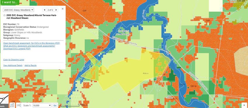
Ecology and risks on site explained
Current mapping (Naturekit) shows the east end of the site that borders the waterway is mapped as
EVC 68 Creekline Grassy Woodland that is Endangered in the Goldfields Bioregion. Endangered is
defined as
“Endangered
Status code: E
Contracted to less than 10% of former range; OR
Less than 10% pre-European extent remains; OR
Combination of depletion, degradation, current threats and rarity is comparable overall to the
above:
• 10 to 30% pre-European extent remains and severely degraded over a majority of this area;
or
• naturally restricted EVC reduced to 30% or less of former range and moderately degraded
over a majority of this area; or
• rare EVC cleared and/or moderately degraded over a majority of former area.””
2077 50 Alma-Moonlight Road, Alma April 2021Page 12 of 36
Creekline Herb-rich Woodland
Intact example of a remnant patch of EVC 68 Creekline Herb-rich Woodland taken in Wedderburn in
the
Goldfields Bioregion. (source Vic Veg) Occurs to the north side of the site along the waterway and
areas that become inundated by the waterway.
2077 50 Alma-Moonlight Road, Alma April 2021Page 13 of 36 Alluvial Terraces Herb-rich Woodland 2077 50 Alma-Moonlight Road, Alma April 2021
Page 14 of 36

Grassy Woodland

2077              50 Alma-Moonlight Road, Alma   April 2021
Page 15 of 36

Explaining Benchmark

Large trees typically should be 20 per ha or on this site 160 with a measurement around the trunk at
breast height to be at least 70cm

Canopy cover is at least 30% of Eucalyptus species

The understorey is all plant life below the tree canopy and consists of many types of life forms see
Appendix.10 for an explanation

The benchmark explanation example

Medium shrub 3 spp (means typically there should be 3 species in a quality site)

10% cover means Medium shrubs should have at least 10% cover over the site

LF code is the Lifeform code- eg Ms=Medium Shrub

                                                                       This list is an example of
                                                                       common species found in this
                                                                       EVC a more comprehensive
                                                                       list in Appendix.11

                                                                       A pictorial example of site
                                                                       coverage is in Appendix.12
                                                                       and should be referred to by
                                                                       the land manager when
                                                                       monitoring the site.

Shrubs are important factors for retaining birds

2077                    50 Alma-Moonlight Road, Alma                                    April 2021
Page 16 of 36
Bryophytes and Lichens is expected in benchmark site to be 10% cover
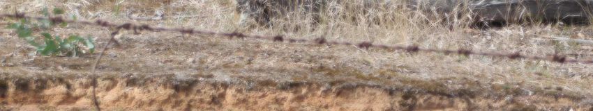
Lichen on site
Example of 10%
cover
Soil crusts in a benchmark site are to also be 10% (example below)
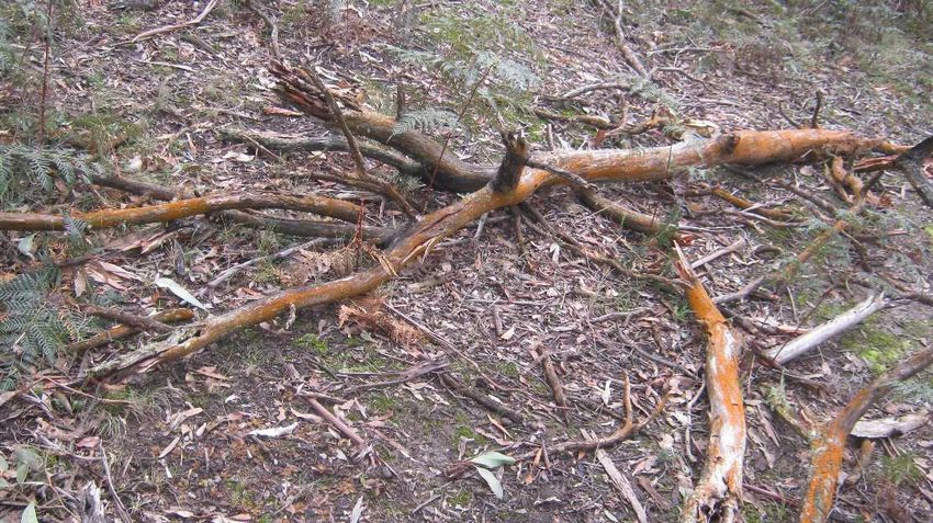
2077 50 Alma-Moonlight Road, Alma April 2021Page 17 of 36 The offset site should have around 20% cover of organic litter (small bits of plant material such as leaves and small sticks); example of 20 cover below. Image of leaf litter on site Dead trees such as this black wattle will lose branches that will fall as logs and rot down into the soil. Larger dead trees may contain hollows that are important habitat for arboreal fauna and birds. It is important to note that a hollow bearing tree takes on average 80 years to grow so their removal is lost for a long period of time even if subsequent trees are replanted. 2077 50 Alma-Moonlight Road, Alma April 2021
Page 18 of 36

Next is a what should be expected from recruitment, organic litter and logs are to be expected to be
monitored for on site.

Sample pic (above from another site) shows how fallen branches mitigates erosion and eventually
rots down to return nutrients that is essential in soils like this of low fertility. This picture is a sample
picture of small logs on site. It is imperative that on this site you should find around 1.6km of logs as
this equates to 20m/0.1ha or 1600m per 8 ha(this site)

                                                                                   Large logs are critically
                                                                                   important not only to
                                                                                   denitrification (to break
                                                                                   down) but to supply
                                                                                   habitat. It is preferred if
                                                                                   large logs make at least
                                                                                   30% of the log
                                                                                   component. Typical
                                                                                   large log shown here

2077                      50 Alma-Moonlight Road, Alma                                         April 2021
Page 19 of 36
This is the last component of the EVC Benchmark and it lists typical weed species
Horehound (Marrumbium vulgare) has
been seen on site.
Wild Rose was evident on site
Aira elegantissima was not seen on site possibly too dry at the time of the survey.
A comprehensive list of weeds in the area including noxious and those under the Catchment Protection
Act that are the responsibility of the landowner to monitor for are listed in the weed section.
2077 50 Alma-Moonlight Road, Alma April 2021Page 20 of 36
African Boxthorn was evident on site
Phalaris aquatica was
evident on site
2077 Lot 2 Alma-Moonlight Rd Alma Apr 2021Page 21 of 36
Farm Management
Weeds
Environment Protection and Biodiversity Conservation Act
There are currently no weeds listed on the EPBC Act. The EPBC Act deals with actions that have or
are likely to have a significant impact on a matter of national environmental significance.
Flora and Fauna Guarantee Act
This state legislation lists taxa and communities of flora and fauna that are threatened and
threatening processes. The listed potential threatening processes under the FFG and relevant to
the site are:
• Invasion of native vegetation by Blackberry Rubus fruiticosa
• Invasion of native vegetation by ‘environmental weeds’
• Land clearance for agricultural use
• Predation by European red fox
• Predation by feral cats
• Loss of biodiversity/shade/windbreak/moisture retention
Catchment and Land Protection Act.
The catchment and Land Protection Act is the main legislation tool in Victoria and is administered
by DELWP. Noxious weeds have the potential to threat primary production and to biodiversity. It is
the responsibility of the land holder to monitor and control the spread of noxious weeds.The CaLP
Act lists certain weeds as noxious and there are 4 categories:
• State Prohibited (S)
• Regionally Prohibited (P)
• Regionally Controlled ( C)
• Restricted (R)
There are weeds listed in the area that fall under the CaLP Act such as:
• Rosa ruginosa ( C)
• Lycium ferocissimum ( C)
2077 Lot 2 Alma-Moonlight Rd Alma Apr 2021Page 22 of 36
• Marrubium vulgare ( C)
• Phalaris aquatica
State Prohibited weeds
These invasive plants either do not occur in Victoria but pose a significant threat if they invade, or
are present, pose a serious threat and can reasonably be expected to be eradicated. If present,
infestations of a State prohibited weed are relatively small.
They are to be eradicated from Victoria if possible or excluded from the State. The Victorian
Government is responsible for their eradication, but under Section 70(1) of the CaLP Act, it may
direct land owners to prevent their growth and spread.
Regionally controlled weeds
These invasive plants are usually widespread in a region. To prevent their spread, ongoing control
measures are required. Land owners have the responsibility to take all reasonable steps to prevent
the growth and spread of Regionally controlled weeds on their land.
Restricted Weeds
This category includes plants that pose an unacceptable risk of spreading in this State and are a
serious threat to another State or Territory of Australia. Trade in these weeds and their propagules,
either as plants, seeds or contaminants in other materials is prohibited. (Department of Agriculture-
Victoria 8 May 2017)
Key points for all landowners and land occupiers about noxious weed and pest animal management
Under s 20 of the CaLP Act, all landowners, including the Crown, public authorities and licensees of
Crown lands, must, in relation to their land, take all reasonable steps to:
• avoid causing or contributing to land degradation which causes or may cause damage to land of
another landowner.
• eradicate regionally prohibited weeds;
• prevent the growth and spread of regionally controlled weeds on their land;
• prevent the spread of, and as far as possible, eradicate established pest animals.
In the case of non-compliance with s 20 of the CaLP Act, the government may serve a Directions
Notice and/or Land Management Notice on a land owner outlining measures that must be taken for
the control or eradication of noxious species on their land. Not complying with the conditions of a
Directions Notice or Land Management Notice is an offence and penalties may apply.
2077 Lot 2 Alma-Moonlight Rd Alma Apr 2021Page 23 of 36
The CaLP Act also contains provisions to prevent the spread of declared noxious weeds, through
regulating the purchase, sale, possession for the purposes of sale, display, propagation or transport
of these species into or within Victoria. Under the CaLP Act it is furthermore prohibited to bring into
Victoria, keep, sell or release declared pest animals without an authority (permit).
In summary, it is an offence to:
• sell or trade any restricted weeds;
• remove or sell soil, sand, stone, gravel, fodder or grain likely to contain any part of a noxious weed
without a permit. A person who contravenes any of these prohibitions may be directed to remove
the noxious weed from any infested goods (animal, plants, vehicle, soil, sand, gravel and stone) or
destroy them or restrict the movement if it is likely to spread weeds;
• buy, sell, possess for sale, bring into the State or transport within the State without a permit
noxious weeds, seeds of noxious weeds or any part of a noxious weed capable of growing;
• sell or offer for hire, without a permit from DEDJTR, any machinery that is for primary production
that contains seeds of noxious weeds or other parts of noxious weeds that are capable of growing;
• sell an animal that is carrying the seeds of a noxious weed without a permit from DEDJTR, unless it
is a farm animal being sold directly to a meat processing facility within the meaning of the Meat
Industry Act 1993;
• deposit on land, without a permit from DEDJTR, a noxious weed or a part of a noxious weed that is
capable of germinating;
• import, keep, sell or release any pest animal in Victoria without a valid permit.
• fail to comply with a Directions Notice
• fail to comply with a Land Management Notice
Penalties for offences under the CaLP Act
Land owners should be aware that the maximum penalty for a single offence involving
responsibilities for the management of noxious weeds is approximately $38,000 in 2017/18. For a
single offence of importing, keeping, releasing or selling a prohibited pest animal, the maximum
penalty is approximately $76,000 in 2017/18.
Catchment and Land Protection Regulations 2012
There are also regulations under the CaLP Act which further guide the management of invasive
pests. The CaLP Regulations 2012 specify the four control measures that can be included in a
2077 Lot 2 Alma-Moonlight Rd Alma Apr 2021Page 24 of 36
Directions Notice for each species of declared noxious weed. The four measures are: application of
herbicide; cultivation of the soil; physical removal; and mulching. The regulations also stipulate how
many rabbits a person may keep without a permit. The CaLP Regulations 2012 also specify the two
prescribed measures for the eradication or control of European Rabbits being ripping and sealing all
entrances to the warren. (Department of Agriculture-Victoria 19 January 2018)
Weeds of National Significance (WONS)
Thirty two Weeds of National Significance (WoNS) have been agreed by Australian governments
based on an assessment process that prioritised these weeds based on their invasiveness, potential
for spread and environmental, social and economic impacts. Consideration was also given to their
ability to be successfully managed. A list of 20 WoNS was endorsed in 1999 and a further 12 were
added in 2012.
Landowners and land managers at all levels are responsible for managing WoNS. State and territory
governments are responsible for legislation, regulation and administration of weeds. (Australian
Government nd)
The following weeds are mapped to be in the vicinity of the site and are listed on WoNS:
• Rosa ruginosa
• Lycium ferocissimum
• Marrubium vulgare
• Phalaris aquatica
2077 Lot 2 Alma-Moonlight Rd Alma Apr 2021Page 25 of 36
Methodology
A weed survey was undertaken throughout the study area 2 March 2021 to identify the weed
species present, distribution, cover and abundance.
The study area was traversed by foot and the location of the weed infestation in the study area was
recorded with its relevant coordinates and then translated onto a site map. Special attention was
given to the low lying and drainage lines on site.
A survey of recorded weeds in the area was undertaken by
using the Atlas of Living Australia (Atlas of Living Australia nd)
to a radius of 5km from the site.
The weed coverage was assessed as a percentage of weed
cover, using the weed density shown here (Source: New South
Wales Agriculture, 2004)
Assessment Qualifications and Limitations
The survey was undertaken in late summer which is not an optimal time for floral surveys. Therefore
the historical listing of weeds in the area will be used as well as those weeds identified on site. The
site assessment was completed by Julie Lee from Nrlinks that has a diploma in Conservation and
Land Management.
Results.
Weed species recorded on site
• Rosa ruginosa
• Lycium ferocissimum
• Marrubium vulgare
• Phalaris aquatica
2077 Lot 2 Alma-Moonlight Rd Alma Apr 2021Page 26 of 36
Weed Control
The control of weed species is a key management action within the site and is critical to achieving
good ground coverage. Effective weed control should promote the regeneration of existing
populations of indigenous species and encourage recruitment from soil stored seed. Care should
therefore be taken to ensure this ultimate objective is not compromised by excessive treatment.
Weed control work should be carried out by a suitably qualified contractor.
Whilst all weeds should be treated, emphasis is placed on priority weeds within the offset site.
Priority weeds include woody weeds, all noxious weeds listed under the Catchment and Land
Protection Act 1994 (CaLP) and high threat perennial grasses. High priority weeds that require
immediate attention are:
• Rosa ruginosa
• Lycium ferocissimum
• Marrubium vulgare
The following key management actions will be undertaken to ensure success of the weed
management program:
• Eliminate priority weeds (cover reduced toPage 27 of 36
• Selective herbicide application is preferable to broad area application but clearly the loss of
non-target species needs to be balanced with the threat of incomplete control of the existing
weed population;
• Strategic crash-grazing of paddocks dominated by Brown-top Bent-grass may be considered
during appropriate seasons to enable other species including native perennial grasses to
increase in cover;
• Any weed control should be done in a manner that minimises soil disturbance;
• Where herbicide application is employed, waterway sensitive products and non-residual
herbicides are to be employed;
• Pest plants that reproduce sexually (by seed) are best controlled before seed set. If herbicide
application is proposed after seed set, slashing should be undertaken to ensure seed does not
reach maturity;
• To reduce the amounts of herbicide used, the target biomass should be reduced (e.g. slashed)
before application so the herbicide can also be absorbed by the actively regrowing plants.
Herbicides are only effective when plants are actively growing; and,
• Weed control works should be monitored regularly to assess their effectiveness, perform
follow up works and evaluate the feasibility of management objectives.
Key Performance Indicators
The following key performance indicators have been provided to measure the success of the weed
management program:
• Reduce priority noxious weed cover toPage 28 of 36
Windbreaks
Windbreaks to the west and
north are recommended on site
to reduce the drying effects of
winds to the crops. The soils have
low nutrient and water holding
capacity so these windbreaks
once established will reducing the
drying effects of winds.
It is suggested that native species
from the list in the appendix are
used with a density of trees to be
1 per every 10m (linear) with 4-5
shrubs in 2 rows as shown here.
Increase topsoil
Areas on site have been filled in from previous mining and have a large amount of rock to the
surface. These areas are devoid of topsoil and this will need to be added to supply a suitable topsoil
for root growth. You will need to allow for the addition of at least 10cm of toil soil.
Irrigation
2077 Lot 2 Alma-Moonlight Rd Alma Apr 2021Page 29 of 36
There are two paddocks currently being irrigated and this has enabled a higher capacity of crops;
although salinity is an issue and irrigation can raise the water table on these areas and increase
salinity in the topsoil.
It is recommended that the owner undertake soil testing for salinity levels then create a bund
around each irrigated paddock to control run off. These areas are best planted with Eucalyptus
camaldulensis (River Red Gum) that is suited to periods of inundation/water logging and is salt
tolerant. The addition of the
trees at a 10m spacing will
ensure that any water run off is
used by the trees and does not
enter the water table below.
It is recommended that these
bunds be created around each
irrigated paddock to a similar
format as shown here.
Regeneration-Erosion control
The area to the north where vegetation has been modified by grazing there is a lack of recruitment
and erosion evident along the stream to mitigate this the area will be fenced off. Grazing will be
allowed to reduce biomass (dead grass) prior to summer usually 2- 3 sheep over 4-5 days is sufficient
for this.
All recruiting trees within this area will need to be protected against predation by a simple wire
frame. The area has kangaroos, and the trees can be lost from this predation. It is not suggested
that the area be planted out, but that natural recruitment occur over time.
Weed management will need to be undertaken in this area to ensure that weed growth does not
suppress growth.
Composting
The soils have low fertility and will benefit greatly from the addition of composting. Leaf little green
plant material can be stock piled on site on a suitably prepared flat area. The site is noted as an
example only on the farm management plan but should be located at least 100m from any
waterway.
For any assistance you can call the North Central Catchment Management Authority they run field
days on composting and sustainable farming that will assist in the long-term management of your
soils, increase carbon and provide you with more resilience against climate change.
There are many ways to find out about sustainable farming:
NCCMA website http://www.nccma.vic.gov.au/
2077 Lot 2 Alma-Moonlight Rd Alma Apr 2021Page 30 of 36
Join the sustainable farming page and meet up with other farmers to learn techniques – Central
Victorian Regenerative Farmers https://www.facebook.com/groups/291403711731532
Join Landcare landcare@nccma.vic.gov.au
View previous newsletter on the NCCMA website http://www.nccma.vic.gov.au/landcare#node-27
Increasing soil carbon
Your soil carbon is currently higher than the surrounding large farming properties due to the trees
around the perimeter and is 0-5cm 1.8 and decreases with depth with 5-15cm at 1.6 based on 20%
clay in the top soil the carbon can be increased to 2.1
Soils such as what you have on your site; will be improved with the increase of carbon. This can be
increased by the following:
• Stock control to maintain ground cover to 70% at all times
• No tillage of the soils
• Perennial plants included to the mix of crop species
• No burning off of stubble
• Increase tree planting
• Natural fertilisers
• Control traffic
• Compost teas
Application of gypsum to replace exchangeable sodium with calcium with organic matter.
Other recommendations
In addition to this stubble should be returned to the soil each year instead of burnt to increase soil
carbon. This needs to be worked back into the soil; an application of gypsum and nitrogen are
required at the same time to improve drainage and provide nutrient for the organic matter to break
down. Composted material can be used in replacement of nitrogen if available.
It is imperative to also manage the following:
• Crop cover should aim at least 70% cover at all time.
• Control of rabbits on site as they break to the topsoil and the subsoil is dispersive and will
erode away.
• Continue to use defined tracks on site for vehicle access.
• Rotate crops and allow sites to be fallow.
• Increase diversity in crops and move away from monocrops (just using one species cropped
into the paddock)
2077 Lot 2 Alma-Moonlight Rd Alma Apr 2021Page 31 of 36 Appendix.1. Site Plan 2077 Lot 2 Alma-Moonlight Rd Alma Apr 2021
LEGEND
MA R
YBO
ER
R OU
TH
GH -
STA
EA
LOT.1 9.9 ha
R NA
W
UD
L
R OA EXISTING EXISTING TURNED OVER
D DWELLING AREA-MINING SHAFTS
AL
TREE COVER
411
AD
KER S RO
W AL
LOT.2 42.77 ha
POOR
DAM EXISTING
L Y DRAINAGE
DRIVEWAY
N
ON
IO
M
AT
K
ND
C
NU
AR
I
RA
Y
OF
T
NE
LI
BO
R O
2 10
U GH-
LOT.1 9.9 ha CONTOUR EXISTING EXISTING
S
RO
AG SHEDS EROSION
TA
LOT.2 42.77 ha
AD
RN
A
RE
S
UD
ER
RO
A
T ION
VE
D
N DA
U
O F IN
L IN E
ADE
ER 274
L L W EA TH
A
NOTE: RISKS TO SOIL HEALTH ON SITE ARE DISPERSIVE
LAID
55
SOILS TO THE NORTH, HIGH COMPACTION RISK,
MODERATE LEACHING AND SALINITY
E LE
HA
A D-
210 268
RK
AL
I
34 M
N
A
R
C
RO
O
OU
AD
AD
R
R
T
251
E
35
SE
AD 33
R
R O
VE
HT 36 ALMA
LI G CEMETRY
O N
32
MO
MA-
A L 37
164
38
EROSION ON MINOR WATERWAY ON THE NORTH OF THE
SITE
EXISTING PLAN
SCALE 1:5000 @A3
PROJECT: PROJECT DWG TITLE: DRAWINGS FOR NATURAL
Note: EXISTING PLAN
50 Alma-Moonlight NO: 2077 RESOURCE
The contractor shall verify all dimensions and all underground DO NOT SCALE Rd, Alma West East PLANNING PERMIT ONLY
services at the site before commencing work. The contractor shall LINK PTY LTD
DATE: NOT TO BE USED FOR 54 Frazer Street
NORTH
verify all levels from the consulting engineer prior to construction. FROM DRAWINGS APR 2021 SCALE: 1:5000 @A3 South CONSTRUCTION Clunes 3370
julie@nrlinks.com.au
C Design Copyright to Natural Resource Link Pty Ltd . This drawing is copyright and the property of the designer and must not be retained, used or copied for any other project without the designer's written authority. Do not scale off drawings. Confirm all dimensions on site prior to setting out.Page 32 of 36 Appendix.2. Farm Management Plan 2077 Lot 2 Alma-Moonlight Rd Alma Apr 2021
LEGEND
MAR
YBO
ER
RO U
TH
G H-
STA
EA
RNA
U
W
DR
L
OAD
PROPOSED PROPOSED PROPOSED
EXISTING grazing/fodde r INCREASE
AL
411 DWELLING WINDBREAK FENCE FENCE TOPSOIL
(FENCED)
pasture
R O AD
E RS
W A LK
grazing*
PROPOSED EXISTING DRAINAGE 1 WEEK
Y COMPOST ADD SALINE ANNUAL
NL GRAZE
N
O AREA TOLERANT TREES
IO
RESTORE
AT
K grazing*
D
irrigated
UN
AC VEGETATION
IN
pasture grazing
OF
TR
NE
LI
irrigated NOTE: RISKS TO SOIL HEALTH ON SITE ARE DISPERSIVE
SOILS TO THE NORTH, HIGH COMPACTION RISK,
pasture MODERATE LEACHING AND SALINITY
grazing/fodder
pasture.2 MITIGATE SOIL RISK BY CHANNELLING RUN OFF AROUND IRRIGATED
PADDOCKS AND PLANTING HIGH SALINE TOLERANT TREES TO USE WATER
THIS WILL AVOID INCREASE IN SALINE WATER TABLE.
ERSOSION RISK -LIMIT GRAZING TO BIOMASS CONTROL, ALLOW FOR
N
NATURAL REGENERATION- REDUCES FRAGMENTATION
ATIO
ALL PASTURES TO BE IMPROVED WITH GYPSUM OR SIMILAR TO IMPROVE
UND
grazing/fodder DRAINAGE.
pasture.4 USE SPECIFIED ROADS ONLY TO ALL PADDOCKS TO LIMIT TRAFFIC
O F IN
MOVEMENT.
L IN E
SALINITY MODERATE IRRIGATION, CONTROL RUN OFF AND USE OF
domestic ER EXCESSIVE RUN OFF BY SALINE TOLERANT TREES.
grazing/fodder L L W E A TH SOIL HAS MODERATE LEACHING SO INCREASE CARBON IN SOIL AND
A INCREASE NUTRIENTS.
pasture.1
grazing/fodder 55 INCREASE SOIL DEPTH WITH COMPOSTING TO IMPROVE SOIL CONDITION
AND CARBON.
pasture.3
HA
R
ha
KI
.3 34
N
42
R
.2
C
OT
OA
O
L
U
DR
RT
E S
35 33
ER
OAD
R
VE
HT 36
G
LI
OON 32
M
M A-
AL 37
164
EROSION ON MINOR WATERWAY ON THE NORTH OF THE
SITE
EXISTING PLAN
SCALE 1:5000 @A3
PROJECT: PROJECT DWG TITLE: DRAWINGS FOR NATURAL
Note: FARM
50 Alma-Moonlight NO: 2077 RESOURCE
The contractor shall verify all dimensions and all underground DO NOT SCALE Rd, Alma MANAGEMENT West East PLANNING PERMIT ONLY
services at the site before commencing work. The contractor shall LINK PTY LTD
DATE: PLAN NOT TO BE USED FOR 54 Frazer Street
NORTH
verify all levels from the consulting engineer prior to construction. FROM DRAWINGS APR 2021 SCALE: 1:5000 @A3 South CONSTRUCTION Clunes 3370
julie@nrlinks.com.au
C Design Copyright to Natural Resource Link Pty Ltd . This drawing is copyright and the property of the designer and must not be retained, used or copied for any other project without the designer's written authority. Do not scale off drawings. Confirm all dimensions on site prior to setting out.Page 33 of 36 Appendix.3 EVC 68 2077 Lot 2 Alma-Moonlight Rd Alma Apr 2021
Page 34 of 36

Appendix.4 Weed List

2077            Lot 2 Alma-Moonlight Rd Alma   Apr 2021
Page 35 of 36

Appendix.5 Windbreaks

Trees:

Eucalyptus viminalis Manna Gum

Eucalyptus leucoxylon Yellow Gum

Eucalyptus camaldulensis River Red Gum

Eucalyptus macrocarpa Grey Box

Shrubs:

Acacia pycnantha

Dodonaea viscosa

Bursaria spinosa

Callistemon sieberi

Melaleuca parvistaminea

Acacia paradoxa

Allocasuarina verticillata

Acacia howittii

Callistemon citrinus (variety)

Grevillea rosmarinifolia ( small needle forms)

Kunzea baxteri

2077                         Lot 2 Alma-Moonlight Rd Alma   Apr 2021
Page 36 of 36

Appendix.6 Detailed info on understanding your soil-NCCMA

2077            Lot 2 Alma-Moonlight Rd Alma         Apr 2021
North Central Victoria

          I
Acknowledgment of Country The North Central Catchment Management Authority (CMA) acknowledges Aboriginal Traditional Owners within the catchment area, their rich culture and their spiritual connection to Country. We also recognise and acknowledge the contribution and interests of Aboriginal people and organisations in the management of land and natural resources. Acknowledgments The North Central CMA wishes to acknowledge Ashley Rogers and Mandy Coulson, for their efforts in the compilation of this Soil Health Guide and Score Card. The North Central CMA wishes to acknowledge Melissa Cann, Belinda Pritchard and Rebecca Mitchell, Agriculture Victoria, DEDJTR for their support in reviewing the guide, providing valuable input and for the use of their photographs and reference material. The North Central CMA also wishes to acknowledge Graham Shepherd (BioAgriNomics) and Lyn Kelson (The Green Cocky) for their knowledge and expertise, and NSW Agriculture and Agriculture Victoria for the use of their photographs and reference material. More information For additional copies of the Soil Health Guide or for further information please contact: North Central CMA 628-634 Midland Highway PO Box 18, Huntly VIC 3551 T: (03) 5448 7124 F: (03) 5448 7148 E: info@nccma.vic.gov.au www.nccma.vic.gov.au The North Central Soil Health Guide and Score Card is an initiative of the North Central CMA’s Regional Landcare Facilitator project through funding from the Australian Government’s National Landcare Programme. Disclaimer This publication may be of assistance to you but the North Central Catchment Management Authority and its employees do not guarantee that the publication is without flaw of any kind or is wholly appropriate to your particular purposes and therefore disclaims all liability for any error, loss or other consequence which may arise from you relying on any information in this publication. 2nd Edition, 2016 © North Central Catchment Management Authority, 2016
CONTENTS

Introduction                                       2
Aim                                                2
North Central CMA Region                           3
How to use the Soil Health Guide                  4
Equipment                                          6
Digging the hole                                   8
Sampling Procedure                                 9
Test 1    Groundcover                             10
Test 2    Evidence of Soil Biological Activity    12
Test 3    Soil Colour                             14
Test 4    Soil pH                                 18
Test 5    Texture                                 20
Test 6    Top Soil                                22
Test 7    Soil structure                          24
Test 8    Soil compaction layers                  26
Test 9    Slaking & Dispersion                    28
Soil health score card                            30
References                                        32

                              1
INTRODUCTION
Healthy soils are fundamental to rural living and food
production. Australian soils are among some of the oldest and
most weathered in the world. They generally contain low levels
of organic matter and if not carefully managed can erode and
degrade easily under traditional European farming practices.
Maintaining healthy soils is essential for farmers and land managers in north
central Victoria to support productive agricultural industries, contribute to
food security and deliver soil related ecosystem services (e.g. clean water and
air). A healthy soil is defined as a state of a soil meeting its range of ecosystem
functions as appropriate to the environment. Healthy soils are essential for
healthy plant growth, human nutrition, drinking water filtration and a landscape
that is more resilient to the impacts of drought or flood (Soils For Life, 2015).
For farmers or rural property owners soil is their most valuable asset. It provides
structural support, water and nutrients for plant growth. Understanding soil
types, applying the appropriate management practices and monitoring soil
quality are all important steps in protecting and enhancing soil health.
AIM
This Soil Health Guide for north central Victoria is a easy-
to-read, practical guide to understanding soil types in north
central Victoria.
The guide provides information to help identify possible soil health issues using
nine simple visual tests conducted in the paddock. The tests are cheap and easy,
and can be undertaken using home-made equipment such as wire quadrants.
Observations and results can be used to determine management actions to
improve soil health and assess differences in soil health between paddocks, farms,
management practices and/or growing seasons. Together with the Soil Health
Score Card (see inside back cover), the guide aims to complement laboratory
test results, providing real-time information on a soils physical, chemical and
biological characteristics.
2NORTH CENTRAL
CMA REGION
SWAN HILL
River Murray
KERANG
COHUNA
QUAMBATOOK
PYRAMID HILL ECHUCA
Avoca River
Loddon River ROCHESTER
DONALD
Richardson ELMORE
River
BRIDGEWATER
ST ARNAUD
Campaspe River
MARNOO
Avon River BENDIGO
BEALIBA
CASTLEMAINE
MARYBOROUGH
AVOCA
KYNETON
DAYLESFORD
3HOW TO USE THE SOIL
HEALTH GUIDE
1. Read all the information first
Before heading out into the paddock it is important to read all the information
and organise the equipment.
2. When to test
The Soil Health Guide contains a series of tests which should be carried out
at least once a year during the main growing season (e.g. late winter or early
spring). Avoid taking samples during very dry or wet conditions, extreme heat or
cold temperatures and after fertiliser or lime applications (wait at least three to
four weeks after applications before testing). To compare results between years
or across paddocks, carry out the tests at similar times of year, under similar
conditions and in the same location(s).
3. Prepare your equipment
Prior to testing collect and/or make the equipment (refer to equipment list).
TIP: Set up Test 9 first, as this will take 30 minutes and can be assessed at the end.
4. Select test sites
Firstly, select the paddock(s) for assessment – it could be the farm’s best and
worst soils, or paddocks under different management. For example, perennial
versus annual pastures, or rotational versus continuous grazing. It is important
to select a test site that is representative of the paddock. Try to avoid stock
camps, headlands, watering points or any other sites of unusual traffic. Refer to
sampling procedure. (Adapted from the Soil Structure Assessment Kit – Shelley
McGuinness, Centre for Land Protection Research, 1991).
5. Decide how many cards you need
The score card has provisions to record three results for each of the nine tests.
More cards will be required for additional testing.
TIP: Conduct tests in undisturbed areas of the paddock and along the fence line
to compare results.
46. Carry out the tests
The Soil Health Guide lists 9 tests. The Soil Health Score Card offers space
to record paddock information (e.g. rainfall, pasture type, site location/map,
grazing frequency and so on) and up to three sets of test results. The more tests
conducted within a site/paddock, the better the understanding of soil health,
as results will be more representative. Once confident with the tests, it will take
approximately 30 minutes to carry out all 9 tests.
TIP: Record the date on the score card before filing to compare results over-time.
7. Review the test procedure
Review the selected sites to ensure results are indicative of the area tested.
TIP: It’s also important to regularly review testing procedures to make sure
procedures are consistent between sites over-time.
8. Review the results and follow up on low scores
Line up the test sheets for the areas/paddocks or compare and identify any
differences or similarities across the 9 tests.
TIP: If neighbours or members of the local Landcare or farming group are also
carrying out the tests, get together as a group to compare results and discuss
possible causes and management options.
9. Make a note to repeat the tests after one year.
By carrying out the tests regularly throughout the season and across multiple
years, it will help identify soil health conditions and the implications of different
management practices on soil health.
Note: To complement this guide, ongoing soil extension support is recommended.
5EQUIPMENT
A plastic tub is recommended to hold equipment
• Shovel • Large garbage bag or tarp
• Tape measure • Home-made penetrometer
• GPS or farm map. • Soil pH kit (available from
gardening supply stores)
• Home-made wire quadrant
• 1 litre bottle of rain or distilled
• Hand magnifying lens
water
• 0.5 Litre water bottle
• Shallow dish or transparent cup.
• Large plastic tub
Home-made equipment
A quadrant is used to show a known area when placed on the ground.
Wire quadrant
Make a 30 cm x 30 cm quadrant (square) out of sturdy cardboard or wire.
Alternatively a wire coat hanger can be used, which measures 24 cm by 24 cm
when opened out to form a square.
Penetrometer
A penetrometer is a device to test compaction in the soil. The depth to which
the average person can push the penetrometer into the soil is usually a good
indication of compaction (Shelley, 1991).
A scientific penetrometer with a gauge can be purchased or a home-made one
can be constructed using a piece of wire or steel.
Figure 1: Home-made wire quadrant, steel-rod penetrometer and wire penetrometer
6Option 1 - For the wire method, take a 500mm length of 3.15mm/10 gauge high
tensile wire. Curve 120mm of the length into a handle, the remaining length
forms the penetrometer.
Home-made equipment: Care needs to be taken. Before undertaking rigorous
testing, please ensure equipment is check by a local soil specialist.
Option 2 - Alternatively a home-made penetrometer can be simply constructed
using two pieces of steel rod. Weld a 1100mm length of 10mm steel rod at right
angles to a 400mm length of 20mm steel rod. The tip of the shaft can then be
sharpened into a point. If a hollow piece of rod is used, a hardened tip will need
to be welded to the end.
Modest effort is required when using a penetrometer. If you hit a rock or tree
root, choose another spot. The easier it is to penetrate the soil, the better the
deep root development and water infiltration.
Using a penetrometer in the field to test compaction.
Photo: North Central CMA
7DIGGING THE HOLE
TIP: Dig a hole large enough to have a clear view of one face (Shelley, 1991)
Equipment: Shovel, tape measure and GPS or map to record the location of
the hole(s).
Instructions: Locate the site for the hole(s). If a farm is made up of different
soil types consider completing the tests for each soil type. Record the GPS
location or mark on a map the location of where the tests were completed so
tests can be undertaken at the same location again in the future. (Victorian State
Government, 2001)
Dig a hole 50-60 cm deep (or until rock is hit) by 50-60 cm wide. A hole of
this measurement allows visibility of soil that is most important to plant roots.
Try and remove the first 20 cm of soil as a solid cube in preparation for the soil
structure test. (Victorian State Government, 2001)
Photo: Poprotskiy Alexey, Shutterstock.com
8SAMPLING PROCEDURE
Taken from: http://www.depi.vic.gov.au/agriculture-and-food/farm-management/
soil-and-water/erosion/groundcovering-measuring-tool
When monitoring it is important to make sure that the areas being assessed
are representative of the entire area. If a soil sample is a different colour from
the other sample it should be discarded. The best way to achieve this is to walk
along an imaginary transect line, diagonally across the paddock from post to
post, Figure 2 or take 10 steps in one direction then randomly turn and take 10
steps in the other direction, Figure 3. Points. (Victorian State Government, 2001)
The larger the area the more tests are required. Take a quick walk over the
general area to understand how variable the paddock is and how many tests
should be undertaken. (Victorian State Government, 2001)
Draw a transect roughly on the Soil Health Card and note approximately where
the tests were undertaken, remember to mark on the drawing where north or the
top of the paddock is as a reference point.
TIP: If available, consider (not necessary) using a GPS (Global Positioning
System) to record test site
Figure 2: Transect Figure 3: Zig zag - random
Assessment
points
9TEST
1
GROUNDCOVER
BIOLOGICAL
Why do we need to know about groundcover?
• Groundcover includes both living and dead plant material and litter.
• By understanding and managing groundcover, soils become less susceptible
to degradation caused by erosion from wind and water.
• A healthy soil contains a broad diversity of microbial types and plants
depend on these beneficial soil organisms to help them obtain nutrients and
water from the soil (Victorian Government of Primary Industries, 2005).
• It is beneficial to measure groundcover each year, not only when pasture
growth is low.
Equipment: Wire quadrant.
Test (the best time to assess is prior to the autumn break):
Randomly place the wire quadrant using the sampling patterns on page 9.
Estimate the proportion of groundcover inside each quadrant (includes both
living and dead plant material and litter). (Victorian Government of Primary
Industries, 2005)
Interpretation of results:
Estimating groundcover levels in pasture
20% Groundcover 40% Groundcover 50% Groundcover
1080% Groundcover 90% Groundcover 100% Groundcover
Table 1: Estimating groundcover levels in a cropping situation
Standing Rolled Chained Cultivated
Coverage Stubble Stubble Stubble Stubble
20%
50%
80%
Pasture photos: Greg Lodge, NSW DPI – 20% and 40% cover photographs. Primary Industries South Australia,
1996, Pasture Pics: easy estimation of pasture dry matter levels, Appila / Bundaleer Pasture Group, Appila,
SA - 50, 80 and 100% photographs; Cropping photos: Mallee Sustainable Farming Inc., 2013, Improving Soil
Health and Reducing Wind Erosion project of the Murray Catchment Management Authority.
11You can also read