Farmers' perceptions of options for pasture remediation and recovery following major tephra fall in New Zealand
←
→
Page content transcription
If your browser does not render page correctly, please read the page content below
Australasian Journal of Disaster and Trauma Studies                                                           Volume 24, Number 2

Farmers’ perceptions of options for pasture remediation and
recovery following major tephra fall in New Zealand

                                                                         system preparedness for (and recovery from) tephra fall.
Seethal P. Sivarajan¹,
Jan M. Lindsay¹,                                                         Keywords: tephra fall, soil remediation, pasture
Shane J. Cronin¹,
                                                                         recovery, volcanic eruption, Mt Taranaki, Mt Ruapehu,
Thomas M. Wilson²
                                                                         Taupō, agriculture
1
    School of Environment, University of Auckland, Auckland, New
    Zealand.                                                             Tephra fall is the most common and widespread volcanic
2
    Geological Sciences, University of Canterbury, Christchurch,         hazard following an explosive eruption. Tephra is the
    New Zealand.
                                                                         term used for fragmented material ejected from a
© The Author(s) 2020. (Copyright notice)                                 volcano during a volcanic eruption (Thorarinsson, 1954)
Author correspondence:                                                   and is classified by size into ash (particles less than 2
Seethal Sivarajan,                                                       millimetres), lapilli (2 to 64 mm), and blocks or bombs
School of Environment,
                                                                         (more than 64 mm; Gilbert, Lane, Sparks, & Koyaguchi,
University of Auckland,
Auckland,                                                                1991). Tephra is typically transported by wind in the
New Zealand.                                                             form of ash clouds and deposited onto the exposed
Email: ssiv734@aucklanduni.ac.nz                                         landscape. Tephra fall can damage many sectors of
URL: http://trauma.massey.ac.nz/issues/2020-2/AJDTS_24_2_Sivarajan.pdf   society including critical infrastructure and agricultural
                                                                         systems due to its abrasive, corrosive, and conductive
Abstract                                                                 potential (Craig, Wilson, Stewart, Outes et al., 2016;
Many regions around the world have farms surrounding                     Wilson et al., 2012). Even small amounts of tephra can
potentially active volcanoes that have been dormant for                  cause substantial problems, disrupting transportation,
decades to centuries. Without any recent experience,                     water supply, and water treatment systems, and leading
a new major eruption and tephra fall would present                       to high clean-up costs (Blake, Deligne, Wilson, &
an unfamiliar soil and pasture remediation challenge.                    Wilson, 2017; Blong, 1984; Cronin, Neall, Lecointre,
We interviewed 23 farmers from the volcanic North                        Hedley, & Loganathan, 2003; Hayes, Wilson, Deligne,
Island of New Zealand in order to gain insight into the                  Cole, & Hughes, 2017). At greater thicknesses (more
current understanding of tephra fall risk and associated                 than 100 mm), tephra can cause structural damage to
production recovery strategies needed for the pastoral                   buildings, with falls of more than 500 mm often resulting
agricultural sector. Of the interviewees, 26% had                        in complete collapse (Blong, 2003; Jenkins et al., 2014;
experienced past minor tephra falls on their farms while                 Spence et al., 1996).
70% believed they were at risk of experiencing future                    Past studies on the effects of tephra on agricultural
tephra fall. Around half of all interviewed farmers (48%),               systems have largely focused on short-term impacts
including one who had previously experienced tephra                      from small eruptions (Bitschene et al., 1993; Cronin et
fall, provided suggestions for possible remediation                      al., 2003; Cronin, Hedley, Neall, & Smith, 1998; Cook,
techniques. The remaining half (52%) did not know                        Barron, Papendick, & Williams, 1981; Georgsson &
what to do if tephra were to fall on their farm. The                     Petursson, 1972; Inbar, Ostera, Parica, Remesal, &
farmer-suggested remediation strategies are: 1) waiting                  Salani, 1995; Johnston, Houghton, Neall, Ronan, &
for rainfall to wash away the tephra (for thin falls),                   Paton, 2000; Rubin et al., 1994) and long-term recovery
2) cultivation, 3) re-grassing, 4) ploughing, 5) using                   following large eruptions (e.g., of Mount Hudson in 1991,
fertilizers, 6) flipping the upper 0.5 metres of tephra                  Wilson et al., 2012; and of Cordón Caulle in 2011, Craig,
and soil, and 7) physical removal. A key barrier to                      Wilson, Stewart, Outes et al., 2016). In the long term
effective recovery is lack of rapid access to appropriate                (decades to centuries), addition of volcanic material
knowledge during and following a tephra fall. These                      can have positive effects on drainage, aeration, fertility,
findings provide potentially useful treatment strategies                 and water retention of soil (Cook et al., 1981; Nanzyo,
for heavy tephra fall on pasture and a key reference                     Shoji, & Dahlgren, 1993; Warkantin & Maeda, 1980).
amongst the farming community when considering farm                      However, in the short-term, apart from the addition

                                                                                                                                 89
trauma.massey.ac.nz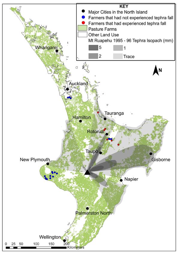
Sivarajan et al. Australasian Journal of Disaster and Trauma Studies
Volume 24, Number 2
of some beneficial nutrients such as sulphur (Cronin, than 10 mm thick across 7,500 km2. Over 962 km2 of
Hedley, Smith, & Neall, 1997), physical impacts are this was agricultural land that was seriously affected
likely to be negative (Wilson, Cole, Cronin, Stewart, & by tephra fall, with damage to crops, livestock, and
Johnston, 2011). fisheries producing a loss of US$86 million (Mercado,
1996; Wilson, Cole, Cronin et al., 2011).
Volcanic soils are highly suited for agriculture and
horticulture due to their high natural fertility, stability, In New Zealand, tephra falls associated with the
good drainage characteristics, and high water-holding 1995/1996 Mt Ruapehu eruption in the North Island
capacity (Annen & Wagner, 2003; Cronin et al., 1998; covered more than 27,000 km2 of primary production
Shoji, Dahlgren, & Nanzyo, 1993; Wilson, Cole, Cronin (Figure 1), causing starvation and fluorosis in thousands
et al., 2011). Past studies have shown that tephra fall can of livestock (Cronin et al., 1998). While there has been an
cause considerable immediate impacts on agricultural increasing focus on documenting the impacts of tephra
systems. The 1980 eruption of Mt St Helens, United fall on agricultural systems in the published literature,
States of America, resulted in tephra being dispersed there has been little focus on recovery strategies,
across 391,000 square kilometres, burying pastures including evaluation of pasture and crop rehabilitation
and crops and resulting in an estimated US$100 million strategies (Neild et al., 1998; Wilson & Cole, 2007;
worth of crop losses at the time (Cook et al., 1981; Wilson, Cole, Cronin et al., 2011). Available literature
Johansen et al., 1981; Folsom, 1986; Lyons, 1986; stresses the importance of adapting strategies to the
Wilson, Cole, Cronin et al., 2011). The eruption of Mt diverse physical and chemical characteristics of tephra
Pinatubo, Philippines, in 1991 dispersed tephra more falls, the local soil and climatic factors, and the capacities
(including knowledge, finance, and technology) of the
farmer (Cook et al., 1981; Craig, Wilson, Stewart, Outes
et al., 2016; Cronin et al., 1998; Folsom, 1986; Lyons,
1986; Wilson, Cole, Cronin et al., 2011).
Following the 1995/96 Mt Ruapehu eruption sequence,
the influence of tephra on agriculture is a key unanswered
question. Past studies have largely focused on the
impacts of tephra on soil, flora, and fauna health (Craig,
2015). Further, the pastoral agricultural context of New
Zealand has changed markedly since the Mt Ruapehu
event, with dairying land use increasing by 42.4%
between 2002 and 2016, to reach 2.6 million hectares.
In 2016, the total area for all agriculture and horticulture
use was 45.3% of New Zealand’s total land area (12.1
million ha; StatsNZ, n.d.). Intensively farmed pastoral
land is common across the soils of both volcanic and
sedimentary parent material in New Zealand (Hewitt,
Barringer, Forrester, & McNeill, 2010; Figure 1). In the
event of large eruptions, such as might be expected
from Mt Taranaki, it is estimated that more than 500
farms could be covered with more than 50 mm of tephra
(Wilson, Gravley, Leonard, & Rowland, 2009). In this
case, farmers would be faced with the difficult task of
removing or rehabilitating tephra to return to production.
Tephra fall of less than 20 mm adds beneficial macro
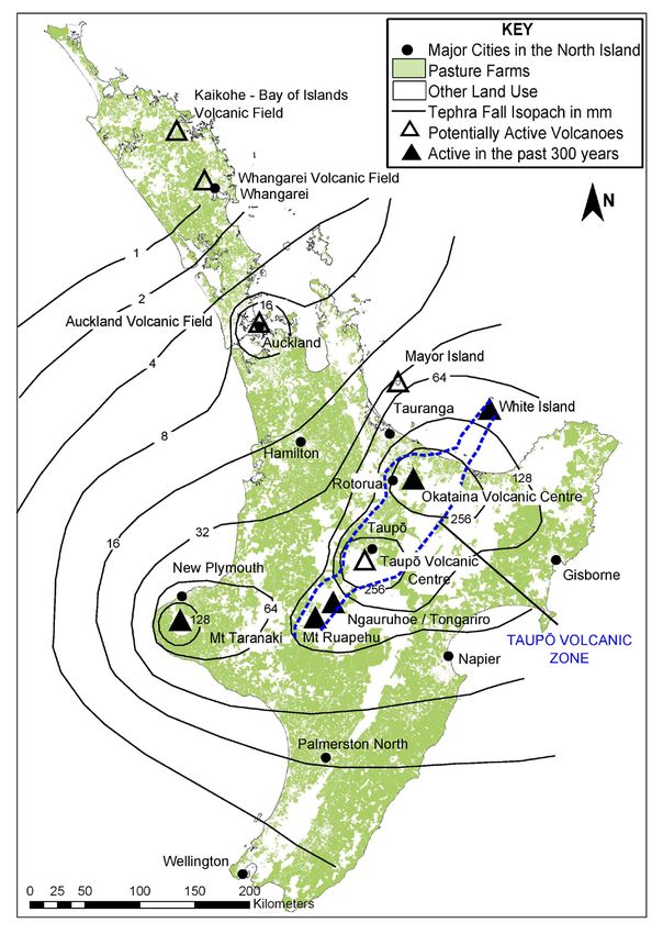
Figure 1. Isopachs in mm of the three largest 1995 and 1996 and micro-nutrients to the soil as well as influencing pH
Ruapehu tephra falls (adapted from Cronin et al., 1998). Red and adding harmful elements (Ayris & Delmelle 2012).
dots show the farm locations of interviewed farmers who reported
that they had experienced tephra fall in the past. Land use data Characteristics such as thickness, density, grain size,
from Agribase, (2018). Accessed 14th January 2019 at www. and composition of tephra influence the type and extent
asurequality.com/our-solutions/agribase/. of impacts caused (Jenkins et al., 2015). Generally a thin
90
trauma.massey.ac.nzAustralasian Journal of Disaster and Trauma Studies Sivarajan et al.
Volume 24, Number 2
(less than 2 mm) coating of tephra can be washed away We infer from these past studies that farmers in New
by rain, while tephra falls of 10 to 100 mm thickness may Zealand may be best able to respond to a volcanic crisis
be remediated over one to five years by cultivation and if they have an accurate perception of the risk, have
in some cases may boost pasture growth (Craig, Wilson, past direct experience of volcanic eruptions, and if they
Stewart, Villarossa et al., 2016). Cultivation prevents re- have an understanding of appropriate preparedness
mobilization of tephra (e.g., by wind or into waterways) and recovery measures. Indeed, the uncommon and
and promotes aeration and bioturbation (where plants complex nature of volcanic hazards necessitates access
or animals rework sediments) to encourage mixing of to expert information by affected communities in order
tephra into the soil (Neild et al., 1998). With thicker to lead their risk management decisions (Paton, Smith,
tephra falls, more intense remediation is needed to Daly, & Johnston, 2008).
counter its low organic material content, low water Here, we present the results of semi-structured interviews
holding capacity, low cation-exchange-capacity, and low with dairy and beef farmers from South Auckland, Bay of
natural fertility. The options for remediation are similar to Plenty, Rotorua, and Taranaki districts in New Zealand
cases of flood deposition where thick deposits smother to explore their views and perceptions of volcanic risk,
the existing soil and pasture; however, flood silt deposits tephra hazard, and possible consequences of tephra
are generally more fertile, with higher organic content fall as well as perceptions of possible remediation
(Hefting et al., 2004; Lockaby, Wheat, & Clawson, 1996). techniques for recovering pastures and soils following
There have been few historical eruptions with major tephra fall. As far as we are aware, this paper presents
tephra falls to learn from in New Zealand. Studies on the first account of farmers’ views on remediation of
volcanic risk perception in other local communities with tephra-affected pastures and soils. The farmers’ insights
past experience of hazardous events are therefore may guide future work on building farmer resilience and
provide a basis for future field and laboratory testing of
important to consider: an approach also recommended
possible rehabilitation techniques.
in past work (e.g., Dominey-Howes & Minos-Minopoulos,
2004; Greene, Perry, & Lindell, 1981; Gregg, Houghton, Tephra Hazard in New Zealand
Johnston, Paton, & Swanson, 2004; Lavigne et al., 2008;
It has been estimated that about 25% of the world’s
Murton & Shimabukuro, 1974; Perry, Lindell, & Greene,
historical and prehistorical eruptions with a volcanic
1982). A study carried out by Jóhannesdóttir and
explosivity index (VEI) of five or more were from the
Gísladóttir (2010) in the village of Vik in southern Iceland Central North Island of New Zealand. This region
revealed that the interviewees were well aware of their contains the world’s highest concentration of youthful
volcanic risk, but their lack of mitigation, prevention, rhyolite volcanoes (Simkin & Siebert, 1994; see Figure
and preparedness was due to experiencing no similar 2). In the central North Island, andesitic volcanism
hazardous event during their lifetime. According to a started circa two million years ago and was joined by
study carried out by Bird, Gísladóttir, and Dominey- voluminous rhyolitic (plus minor basaltic and dacitic)
Howes (2009) in south Iceland, an active response by activity from at least circa 1.6 million years ago (Wilson
the public (and farmers) during a volcanic emergency et al., 1995). Brief characteristics of different types of
depends not only on their perception of the possible magma are given in Appendix 1 and a brief summary
risk, but also their knowledge of preparedness actions. of past volcanic activity in New Zealand is given below.
Several key studies have been carried out on risk The Taupō Volcanic Zone of New Zealand contains
perception in New Zealand; these have found that both andesitic stratovolcanoes (e.g., Mt Ruapehu and
knowledge of a hazard increases with the degree of Mt Tongariro), built by comparatively frequent small
expected maximum hazard, the degree of damage from eruptions, and predominantly rhyolitic calderas (e.g.,
prior events, and the amount of information available Okataina and Taupō volcanic centres), which can
about the hazard (Johnston, Bebbington, Lai, Houghton, produce much larger eruptions at longer intervals (Cole
& Paton 1999). Paton, Millar, and Johnston (2001) 1979; Wilson et al., 1984). There have been numerous
concluded that, for Mt Ruapehu volcano, the perception recent and historical tephra-generating eruptions from
of risk typically increases with people’s proximity to the the Taupō Volcanic Zone. Widespread tephra layers
volcanic centre, the likelihood of a future disaster, the preserved in sedimentary records on the ring plain to
impact level, and past direct experience of hazards. the east of Mt Ruapehu reveal that this stratovolcano
91
trauma.massey.ac.nzSivarajan et al. Australasian Journal of Disaster and Trauma Studies
Volume 24, Number 2
August 2012 after being inactive for 115 years. The
eruption occurred from the upper Te Maari Crater on the
volcano’s northern flanks, which was previously active
in 1869, 1892, and 1896 - 1897 (Cronin et al., 2014).
These past eruptions were short Vulcanian and phreatic
explosions, releasing tephra plumes with wet surges
and lahars; the approximately 400,000 cubic metres of
tephra generated during the 2012 event was dispersed
over a vast area (Cronin et. al., 2014).
The largest historical eruption from the Taupō Volcanic
Zone was a basaltic Plinian eruption from Mt Tarawera
and nearby Lake Rotomahana of the Okataina Volcanic
Centre, in the early hours of 10 June, 1886 (Keam,
2016). The eruption started from the preexisting
Tarawera rhyolite dome, producing a tephra column with
a height estimated at 28 km (Walker, Self, & Wilson,
1984), and then extended into Lake Rotomahana. The
eruption from this latter area was much more violent due
to the interaction of water and deposited a thick layer
of Rotomahana mud on surrounding areas. The whole
eruption of about 2 km3 lasted only a few hours during
the morning of 10 June, 1886 (Keam, 2016). One of
the most productive caldera systems in the world is the
Taupō volcanic centre (Figure 2). The latest eruption
from Taupō was in 232 ± 5 AD (Hogg, Lowe, Palmer,
Figure 2. Tephra hazard map with tephra thickness in mm for
Boswijk, & Ramsey, 2012) and ejected 35 km3 of magma
a 10,000-year return period for all significant volcanic sources
(adapted from Hurst & Smith 2010). Locations of potentially active (Potter, Scott, Jolly, Johnston, & Neall, 2015).
volcanoes along with major towns in New Zealand’s North Island
are also shown. Land use data from Agribase (2018). Accessed Mt Taranaki, a 2,518 metre high andesitic stratovolcano
14th January 2019 at www.asurequality.com/our-solutions/ situated in the Taranaki region (Figure 2), has erupted
agribase/.
over 220 times in the last 30,000 years (Damaschke,
has produced a total of 19 major eruptions, interspersed Cronin, Holt, Bebbington, & Hogg, 2017), spreading
with smaller events, over the past circa 1,800 years tephra over the surrounding areas and as far north as
(Moebis, Cronin, Neall, & Smith, 2011). The most recent the city of Auckland (about 270 km away; Sandiford,
eruption from Mt Ruapehu took place as a series of Alloway, & Shane, 2001; Shane 2005). Mt Taranaki
events between September 1995 and August 1996 is located in the middle of an economically significant
(Cronin et al., 2003; Johnston et al., 2000; Newnham, region of New Zealand, which contributes 10% of the
Dirks, & Samaranayake, 2010). A large eruption on June country’s total dairy land (Ballingall & Pambudi, 2017).
17, 1996 dispersed large amounts of volcanic tephra According to the best currently available model for
over a wide area reaching more than 300 km to the Mt Taranaki, it is estimated that there is a 33 – 42%
north and east of Mt Ruapehu (Figure 1). The eruption chance of an eruption occurring within the next 50 years
column reached an estimated 7 - 10 km, with the axis (Damaschke et al., 2017).
of tephra dispersal sweeping westwards across the
The basaltic Auckland Volcanic Field (AVF) has been
central North Island as the wind direction shifted from
active over the last circa 200,000 years and consists of
SW to SE (Cronin et al., 2003). An estimated 7 million
53 monogenetic (only erupting once) eruptive centres
tons of tephra were dispersed, with light tephra falls
(Leonard et al., 2017). Lava flows and tephra falls are the
over the nearby cities of Taupō and Rotorua (Cronin et
most widespread deposits of the AVF (Kereszturi et al.,
al., 1998; Figure 1).
2014). Although there have been no historical eruptions
The adjacent Mt Tongariro of the Tongariro Volcanic from the AVF (i.e., since written records began), the
Zone erupted suddenly at 2350 hours NZST on 6th most recent eruption, forming Rangitoto island about
92
trauma.massey.ac.nzAustralasian Journal of Disaster and Trauma Studies Sivarajan et al.
Volume 24, Number 2
600 years ago, was witnessed by early Māori. Future Method
eruptions from the AVF are likely to be smaller than
Semi-structured Interviews
those from New Zealand’s andesitic and rhyolite centres
further south. Our study used semi-structured interviews, a widely
used method of data collection within the social sciences
A Probabilistic Volcanic Hazard Model (PVHM) (Bradford & Cullen, 2013). Such interviews are valuable
developed for New Zealand by Hurst and Smith (2010) because they allow researchers to explore subjective
estimates the likelihood of tephra deposits of any given viewpoints (Flick, 2009) and to gather in-depth accounts
thickness at any site, based on the frequency-magnitude of people’s experiences. Typically, an interview schedule
relations of all significant volcanic sources and wind is used, which enables the researcher to address a
distribution statistics. They found that a typical 10,000- defined topic while allowing the respondent to answer
year period could result in the deposition of up to 300 in his or her own terms and to discuss issues and
mm of tephra in many central North Island locations topics pertinent to them (Choak, 2013). In this sense,
(Figure 2). the interview should resemble a flowing conversation
The magnitude of possible eruptions that could affect (Rubin & Rubin 2011; Choak, 2013). The methodological
components of the interview were approved by the
agriculture in New Zealand ranges from minor andesitic
University of Auckland human participation ethics
events such as the 1995/1996 Mt Ruapehu eruptions,
committee (Reference number: 016940).
up to a major rhyolitic Plinian event, such as the 232
AD Taupō eruption (Wilson et al., 1995), which would In this study, 23 farmers from South Auckland, Bay of
eliminate agriculture in the central North Island for an Plenty, Rotorua, and Taranaki districts were interviewed.
extended time period. Mt Taranaki produces many The regions were selected due to their susceptibility
events with typically low volume; however Torres- to tephra fall from Taupō Volcanic Zone and Taranaki
Orozco, Cronin, Pardo, and Palmer (2018) report a volcanoes (Figures 1 and 2). According to the PVHM
Plinian eruption every 300 years on average over the model developed by Hurst and Smith (2010) for New
past 5,000 years. Zealand, 10,000-year return period eruptions are
capable of depositing up to 300 mm thick tephra falls
Although New Zealand has a comprehensive monitoring over most of the central North Island. The participants
network1 and warning system for future eruptions, there themselves were selected by snowball sampling with
are few mitigation measures for impacts to pasture the help of Dairy NZ (an industry research organization)
under rapid accumulation of heavy tephra fall. During and the Taranaki Regional Council. Dairy NZ has regular
volcanic unrest periods, GNS Science release tephra fall meetings with their farmer groups; we were invited to
prediction maps with their Volcanic Alert Bulletins. These attend a meeting at Karaka in the Auckland region on
show the likely tephra fall location and thickness for July 5th, 2016, where a brief introduction to the study
that particular day, given the current weather patterns, was given to the farmers present. This encouraged
thus providing very short notice to farmers in the tephra the immediate participation of two farmers. Dairy NZ
hazard zone. If more time were available (e.g., months subsequently wrote to their farmer groups seeking
to years) possible preparatory measures could be taken, participants for the study, which resulted in two more
such as de-stocking or moving livestock. The cost of farmer participants; these two farmers then spread the
stock evacuation is exceptionally high (Wilson, Dantas, word about the research within their network, resulting
& Cole, 2009) and thus such a warning would likely need in a further eight farmer participants. The Taranaki
to have a high degree of certainty for the measures to Regional Council assisted by spreading the word
be economically viable. This degree of certainty is highly about this study amongst farmers in their region; those
unlikely with current technology and understanding of interested in participating then gave their contact details
volcanoes. Far more likely is that only a few days to to the council and were subsequently contacted by the
hours of warning will be possible, and so little can be researchers to arrange the interview.
done other than to evacuate livestock. Post-tephra fall A participant information sheet and consent form were
remediation and pasture recovery thus becomes a key signed by all interviewed farmers before the interview
recovery consideration. and participants were informed that they could withdraw
1 https://www.geonet.org.nz/volcano/ from the study at any point. Eleven farmers were
93
trauma.massey.ac.nzSivarajan et al. Australasian Journal of Disaster and Trauma Studies
Volume 24, Number 2
interviewed face-to-face and 12 over the phone, with Results
every interview voice recorded. The interviews were
General Farmer Profile
carried out between July and November 2016, with each
interview lasting between 20 minutes to 1 hour. The Of the 23 farmers interviewed, 21 were dairy farmers
farmers’ answers were recorded in an Excel spreadsheet and two were dairy and beef farmers. The majority
under the appropriate headings and analysed semi- of farmers were highly experienced in dairy farming,
quantitatively. The interview questions consisted of a few with the most experienced farmer having 58 years’
closed and mostly open-ended questions that can be experience and the least experienced 7 years. The
summarized and grouped into the following three areas farms ranged in size from 60 ha to 640 ha. The livestock
(see Appendix 2 for the full list of questions). count per farmer ranged from 170 to 1,825 dairy cows.
All farm production systems were centered on growing
General farmer profile. The first group of questions pasture for either direct livestock consumption or to
obtained general information from the farmer and make supplementary feed, which can then be fed
solicited information such as when they started their to livestock during low pasture growth periods (e.g.,
farming career, whether they were first generation winter) or high-energy demand periods (e.g., calving
farmers, how many hectares they farmed, what kind and milking). The majority of the interviewed farmers
of farming they practiced (dairy of beef), what kind of used a ryegrass (lolium multiflorum) and clover (trifolium
pasture mix they grew on their farm, whether they had repens) mix as their dominant pasture type, with two
tried growing any other crop on their farm, and which farmers growing chicory (cichorium intybus), plantain
crop had been most consistent in terms of making a (plantago lanceolate), and lucerne (medicago sativa)
profit. Farmers were also asked how their farming style as supplementary feed along with ryegrass and clover
had evolved during their time farming, what important mix. Seventeen farmers had experienced the effects of
changes they had implemented or encountered on non-volcanic natural hazards on their farm; in order of
their farm, and how these changes affected productivity most-to-least experienced hazard (number of affected
and profitability. They were also asked if their farm farmers in parentheses): drought (10), floods (4), wind/
had experienced any natural hazard events other than storm/cyclone (4), snow/pugging (3), earthquake/heavy
volcanic tephra fall (e.g., flood, landslide, earthquake, rainfall (2), and landslide/infertile soil/coastal erosion (1).
snow, drought). See Supplementary file 1.
Farmer experiences and perceptions of tephra fall Farmer Experiences and Perceptions of Tephra Fall
hazard. The second group of questions were based Hazard
on farmers’ past encounters with tephra fall on their
Of the 23 farmers who were interviewed, only six (five
farm, if any. They were asked if they had experienced
dairy and one dairy and beef farmer, all from the Bay of
tephra fall and if so, when. They were also asked if they
Plenty region) had experienced tephra fall on their farms
considered their farm at risk of receiving heavy tephra
during the 1995/96 eruption of Mt Ruapehu (Figure 1).
fall and what other types of hazards might be associated
These six farmers reported receiving tephra in various
with a volcanic eruption.
thicknesses, including less than 1 mm, a “very light
Farmer thoughts on strategies to combat tephra fall dusting” (two farmers), 10 mm, 15 – 25 mm, and a “quite
effects. The third group of questions was designed to reasonable” amount.
explore farmers’ thoughts on techniques for remediating
Sixteen of the farmers (around 70%) stated that heavy
tephra-affected soils. All farmers were asked to speculate
tephra fall is a possible threat to their farms, while six
what they thought could be done if they were faced with
(26%) believed that they were free from this hazard,
light tephra fall (0 to 10 mm in thickness) and medium to and one was unsure (see Figure 3). The 16 farmers
heavy tephra fall (10 to 300 mm in thickness) covering who agreed their farms were at risk of heavy tephra
their pasture. If they had experienced any natural hazard fall included five who had already experienced tephra
events other than tephra fall (e.g., flood, drought) or fall on their farm. Interestingly, the remaining farmer
soil damage or poor fertility, they were asked how they who had already experienced tephra fall on their farm
recovered from the resulting effects. believed this was a rare, once in a lifetime situation.
We acknowledge that the expected frequency of thin
tephra falls in the North Island of New Zealand is much
94
trauma.massey.ac.nzAustralasian Journal of Disaster and Trauma Studies Sivarajan et al.
Volume 24, Number 2
for rainfall to wash tephra from pasture. In this case, the
farmers anticipate that the grass and soil would return
to their original conditions and could continue to be
used as before. Depending on the season, participants
also considered irrigating the tephra-affected soil as a
recovery option. Irrigation would also have the effect of
washing away much of the tephra settled on the pasture.
Using fertilizers (2 farmers): Two farmers recognized
Figure 3. Schematic illustration of farmer responses to the question:
that tephra fall could cause an imbalance of soil nutrients
“Do you think there is a risk that your farm could experience heavy
tephra fall?” and suggested that this could be remediated by targeted
fertilizer mixtures.
greater than for thick tephra falls. Nine of the 16 farmers
Cultivation/Re-grassing (8 farmers): In the event of
who considered their farm at risk of heavy tephra fall
thick tephra fall, farmers thought that re-grassing or
described additional possible volcanic hazards and
cultivating the affected paddock would be useful. In
impacts (see Figure 4).
this method the whole paddock would be sprayed with
Farmer Thoughts on Strategies to Combat Tephra herbicide (if needed), followed by tilling to produce a
Fall Effects good seed bed.
The six farmers who experienced the 1995/96 Mt Ploughing (3 farmers): For medium to thick tephra
Ruapehu eruption did not notice any adverse effects fall, farmers recommended ploughing as a possible
on the soil or on their farm and waited for rainfall to recovery technique. It was suggested that ploughing
wash the tephra coat from the pasture. Around half
6 to 10 inches (approximately 10 to 15 cm) below the
of all interviewed farmers (11; 48%), including one
top-soil and mixing the tephra with soil would reduce the
who had previously experienced tephra fall, provided
toxicity of tephra and reduce its impacts.
suggestions for possible remediation techniques. The
remaining half (12; 52%) did not know what to do if Machine removal (3 farmers): Three of the farmers
tephra were to fall on their farm. Of the 16 farmers who thought that, in the case of heavy tephra fall conditions
identified heavy tephra fall as a risk to their farm, nine (where tephra forms a thick coat over the pasture soils),
were able to suggest possible remediation measures. excavating or grading the tephra using heavy machinery
Overall, the following possible remediation techniques would be the only option left to recover the pasture.
were suggested (with the number of farmers mentioning
Flipping (1 farmer): One participant, from the Bay of
the technique in parentheses).
Plenty, practised flipping on his farm in order to bring
Rainfall/Irrigation (9 farmers): In the event of light back to the surface the buried layers that were once
tephra fall, participants suggested that they would wait fertile top soils prior to the 232 ± 5 AD Taupō eruption
(Hogg et al., 2012). This reportedly gave excellent
pasture growth and soil fertility results. Flipping is a
method where a large excavator is used to invert the
soil profile, bringing the 1 to 1.5 m deep sub-soil to the
top. The dairy farmer who practised flipping gained
an increase of 40% dry matter over his normal soil.
The farmer suggested that flipping could be an ideal
remediation strategy for heavy tephra fall.
Farmers also suggested a few remediation strategies
that they had used, or were aware of, to recover soils
following other adverse natural events, suggesting
Figure 4. Volcanic hazards and possible impacts identified by the these may also be useful in the remediation of tephra
nine farmers who also considered their farm at risk of heavy tephra
fall. affected soils.
95
trauma.massey.ac.nzSivarajan et al. Australasian Journal of Disaster and Trauma Studies
Volume 24, Number 2
Organic fertilizer/Cow-shed effluent/Chicken manure eruption of Vulcan Hudson in Chile, over 1 m of tephra
(13 farmers): Over half of the farmers interviewed was deposited around 20 to 40 km from the volcano
sprayed their cow-shed washings onto paddocks, (Wilson, Cole, Stewart, Cronin, & Johnston, 2011). The
which helps enhance pasture growth, increases organic farmers in this area tried different remediation strategies
nutrients in the soil, and also increases the number and to recover pastures, such as applying fertilizers and
growth of worms in soil. They stated that this method sowing different types of grasses including indigenous
can be utilised to increase organic nutrient levels in the and foreign ryegrasses and red and white clovers. While
soil, which is likely to drop even after light tephra fall. the grass had moderate success, adding fertilizer alone
did not help due to rapid leaching (Wilson, Cole, Cronin
Liming (9 farmers): Over a third of interviewed farmers
et al., 2011). Other farmers in the area spread hay over
practised liming on their farm to maintain the pH of soil
the tephra to increase the organic content of the soil,
to enhance grass growth. Their comments suggested
which helped but was expensive (Wilson, Cole, Cronin
that considering the acidic nature of tephra, liming could
et al., 2011). Areas with light tephra fall (10 mm) were
be an appropriate recovery method following tephra fall.
able to be rehabilitated rapidly by just irrigation (Wilson,
Different grass mix (2 farmers): Farmers suggested Cole, Cronin et al., 2011). Areas further away from the
that using a different grass mix would be useful in order volcano received 200 to 300 mm of tephra, which was
to recover light tephra-affected soil. It was suggested ploughed using tractor-mounted ploughs or rotary hoes.
that a mix of ryegrass, clover, and chicory gave good Other farmers tilled the thick tephra deposits into the soil
results with respect to pasture growth. The farmers using rakes and shovels, which was effective and led
used this technique to overcome the damage caused by to higher yields within two to three years (Wilson, Cole,
pugging and heavy rainfall. They perceived that using Cronin et al., 2011). It is clear from past experience
different grass mix on tephra can be useful as different around the world that remediation strategies need to
grass types can vary in their tolerance to soil conditions. be designed based on the individual context, taking into
It is also worth noting that several farmers mentioned consideration factors such as farming system, climate,
other response strategies such as de-stocking the soil type, farm topography, tephra chemistry, thickness
farm and/or providing external or supplementary feed and grain size, and availability of fertilizers, labour, and
(Supplementary file 1). These suggestions highlighted machinery. This array of possible contexts means that
that pasture rehabilitation must be considered in the tailoring remediation measures to specific events may
wider context of the recovery of the farming system as be challenging. This study attempts to fill this gap by
a whole. shedding light on farmer perceptions of potentially useful
treatment strategies for heavy tephra fall on pasture in
the New Zealand context.
Discussion
Extreme natural hazard events such as flooding, Farmers’ Perceptions of Tephra Fall Hazard
landslides, or deposition of volcanic material such as Sixteen of the 23 interviewed farmers (nearly 70%)
tephra fall may completely disturb or bury soils. In cases considered heavy tephra fall as a possible threat in
of extreme volcanic deposition, farmers must abandon the future, yet only nine of these suggested potential
the land (Wilson, Gravely et al., 2009). There are several mitigation strategies. Participants recognized the rarity of
global examples where thick volcanic tephra fall has these events, noting none in the past 50 years. Farmers
forced temporary abandonment of farms, including that experienced tephra fall had only experienced minor
eruptions at Hekla volcano, Iceland (Thorarinsson falls, which contributes to their overall perception of
1979), and Vulcan Hudson, Chile (Bitschene et al. 1993; volcanic risk being low. This concurs with past work
Scasso, Corbella, & Tiberi, 1994). In other situations, which has found that knowledge of a hazard is directly
physical or biological remediation of the new tephra- related to the proximity of the hazard source, degree
covered soils may be possible. of expected maximum hazard, the degree of damage,
experience of prior events, and information available
Following the 1943 to 1956 eruption of Volcán de
(Johnston et al., 1999; Paton et al., 2001).
Parícutin, Mexico, farmers discovered that they could
recover production by cultivating tephra into the Interestingly, the farmers who experienced tephra fall
underlying soil (Luhr, Simkin, & Cuasay, 1993; Ort et on their farms from the Mt Ruapehu 1995/1996 eruption
al., 2008; Rees & Grayson, 1979). Following the 1991 perceived a range of tephra thicknesses from less than
96
trauma.massey.ac.nzAustralasian Journal of Disaster and Trauma Studies Sivarajan et al.
Volume 24, Number 2
1 mm to 15 to 25 mm, despite being located in the areas method, potentially also the most expensive: namely, to
thought to have received trace amounts of tephra from excavate and invert (flip) the soil to expose the sub-soil.
this eruption (Figure 1). We believe this represents an Below we discuss these strategies in the context of past
over-reporting of tephra thickness by lay people, which work and provide a summary in Figure 5.
was noted during this and other past eruptions in New
Six farmers who had experienced light tephra fall on
Zealand.
their farm during the 1995/96 Mt Ruapehu eruption
Over half (12; 52%) of the farmers were unable to waited for rainfall to wash away the tephra. This also
suggest remediation strategies and most had given occurred in distal areas after the 1991 Vulcan Hudson
the topic little thought. This may relate to a lack of eruption (Wilson, Cole, Cronin et al., 2011). In many
past experience of volcanic eruptions coupled with a small eruptions, this would be the only action needed,
sense of not being vulnerable to this hazard. A sense but it implies that supplementary feed is required during
of vulnerability encourages response to warnings and the waiting period.
implementation of preventative measures (Johnston
et al., 1999). Limón-Hernández et al. (2009) found Two farmers suggested applying fertilizers could speed
communities at El Chichón volcano in Mexico needed a up remediation, but we note that this was not effective
comprehensive educational programme long before an when applied in the Upper Ibáñez valley after the 1991
eruption to be prepared. This type of education would eruption of Vulcan Hudson (Wilson, Cole, Cronin et al.,
also be important for New Zealand farmers that may 2011). However, different fertilizer and liming treatments
face major tephra falls in the future. have proven to be useful in boosting post-eruptive
growth in the New Zealand context (Cronin et al., 1997).
Farmer-suggested Remediation Techniques
Nearly 35% of participants supported cultivation/
Our survey results show that farmers acknowledged
re-grassing to recover pasture soils following heavy
the importance of knowing effective tephra remediation
tephra fall; this was effective at Volcán de Parícutin,
strategies for pasture soils. Farmers suggested
Mexico (Luhr et al., 1993; Ort et al., 2008; Rees &
some conventional methods of remediation, such as
Grayson, 1979), and in Chile and Argentina following
cultivation, re-grassing, ploughing, and using fertilizer
eruptions (Wilson, Cole, Cronin et al., 2011). This also
mix. One of the farmers suggested an unconventional
had the benefit of helping to
Tephra thickness Remediation strategy Benefits stabilize the tephra from further
Rainfall / Irrigation* Will help to wash away tephra (Wilson, Cole, redistribution (e.g., by wind or
Cronin et al., 2011) water). Ploughing heavy tephra-
Organic fertilizer (cow Will increase organic content (Wilson, Cole, covered soil was suggested by
shed effluent; chicken Cronin et al., 2011); may not be available in large
our participants for heavy tephra
manure) quantities if de-stocking has occurred
Light tephra fall fall and was also effective at
Fertilizer Supplies nutrients for pasture growth (Wilson,
(0 – 10 mm) Chile Chico, Los Antiguos, and
Cole, Cronin et al., 2011)
Liming May help increase the tephra pH levels as tephra Perito Moreno following the 1991
is typically acidic Hudson eruption (Wilson, Cole,
Different grass mix*# Some grasses may have higher tolerance toward Cronin et al., 2011). In practice,
tephra (Wilson, Cole, Cronin et al., 2011)
cultivation and ploughing can
Cultivation* Helps break the tephra layer and bring the buried
soil to the top (Wilson, Cole, Cronin et al., 2011; be considered a similar process:
Craig, Wilson, Stewart, Villarossa et al., 2016) namely mixing the tephra with the
Medium to Heavy Ploughing* Helps mix tephra and underlying soil (Wilson, soil in preparation for sowing of
tephra fall Cole, Cronin et al., 2011)
(10 – 300 mm) seeds. Treating these collectively,
Removal using heavy Helps get rid of thick tephra layers (Wilson, Cole, 11 (48%) farmers recommended
machinery* Cronin et al., 2011)
this strategy. Indeed, such tilling of
Flipping Will bring sub-soils to the top and bury tephra
tephra into the upper soil horizon
Figure 5. Remediation strategies that could be implemented for light and medium to heavy tephra has proven to speed up recovery
fall based on farmer suggestions and literature review.
* = remediation strategies suggested by farmers that have shown success overseas according to and pasture re-establishment
the literature review. (Craig, Wilson, Stewart, Villarossa
# = has shown success for medium to heavy tephra fall overseas.
et al., 2016).
97
trauma.massey.ac.nzSivarajan et al. Australasian Journal of Disaster and Trauma Studies
Volume 24, Number 2
Removing thick tephra using heavy machinery was cultivation and fertilization in order for the pasture to
suggested by three of the farmers; this approach was establish.
also taken following the Hudson eruption where graders
were used to scrape and remove the tephra (Wilson, Conclusions and Recommendations
Cole, Stewart et al., 2011). Excavation is one of the New Zealand, especially the middle portions of the
oldest remediation methods for contaminated soil North Island, is at risk from heavy tephra fall, with many
(Lambert, Leven, & Green, 2000) and may be useful volcanoes capable of producing tephra fall more than
on smaller farms or for high-value crops. However, the 100 mm thick on pastures. It is important for the New
average farm area amongst the interviewed farmers Zealand agricultural sector to have a clear understanding
was 250 ha, thus removing the thick tephra from such of possible ways to recover from this volcanic hazard,
large areas would be impractical and expensive. The prior to an eruption. There are only a few studies of
advantage of this method is the complete removal of rehabilitation of pasture following thick tephra falls in the
the contaminants (Wood, 1997), but the disadvantages literature, and none of these are from New Zealand. It
include disposing of the removed tephra and the is therefore equally important to investigate potentially
feasibility of this technique on many of New Zealand’s useful local options. Although our study used a small
rugged landscapes. sample which limits the generalizability and strength
Thirteen farmers (57%) reported using organic fertilizers/ of conclusions, our findings usefully illuminate farmers’
manure/cow-shed effluent on their farms to recover perceptions of tephra fall hazard and present insight into
soils degraded due to other causes such as pugging, their experiences and thoughts on effective rehabilitation
floods, droughts, or erosion. Lal, Griffin, Apt, Lave, methods. We have prepared a preliminary guide to
and Morgan (2004) reported that adding crop residues possible rehabilitation strategies for tephra-affected
(green manure) into the soils not only increases the pasture based on the results of our study together with
carbon content but also improves the soil structure. In information from the literature (see Figure 5). Some of
the Upper Ibáñez valley, Vulcan Hudson, hay was used the strategies have only been suggested by farmers and
to increase the organic content of the tephra-affected it is unclear whether they will indeed work. On the other
soils, but it was expensive and only used in places hand, many of the recovery strategies suggested by
where tephra was too thick to be cultivated (Wilson, farmers have proven effective in other parts of the world.
Cole, Cronin et al., 2011). Hay is therefore unlikely to We thus provide preliminary insights and recommend
be a practical solution on large New Zealand farms. It further research to test these suggested remediation
is important to know how tephra would react to low-cost techniques on New Zealand pasture soils under
organic manure such as cow-shed effluent, which is simulated heavy tephra fall. While we acknowledge that
readily available on most dairy farms. Another option pasture remediation is just one aspect of farming system
might be chicken manure, a strategy suggested by one recovery following a volcanic eruption, we believe our
farmer for improving infertile soils (See Supplementary study has the potential to raise awareness amongst the
file 1). Any remediation strategy using effluent would be farming community of tephra fall hazard and to prompt
challenging on a large farm and may require imported the development of possible preparedness strategies
effluent as well as additional machinery. for the farming system as a whole.
Two of the interviewed farmers suggested using different
and hardier grass mixes to speed recovery. This showed
Acknowledgements
success following thick tephra falls (more than 500 mm) The authors acknowledge the support of Dairy NZ and
from the 1991 Vulcan Hudson eruption, especially the Taranaki Regional Council in recruiting participants
indigenous grasses and a variety of foreign ryegrasses interviewed in this study. We thank Geena Campbell
and red and white clovers (Wilson, Cole, Cronin et al., for assisting with the creation of Figures 1 and 2. The
2011). This is similar to a basic form of phytoremediation, study was supported by the University of Auckland
which is often used to stabilize mine tailings and prevent EQC Capability Building fund. SJC is supported by the
leaching of pollutants (Fellet, Marchiol, Delle Vedove, Quantifying volcanic risk program of the NZ Natural
& Peressotti, 2011). This may need to be carried out in Hazards Platform.
conjunction with other remediation methods such as
98
trauma.massey.ac.nzAustralasian Journal of Disaster and Trauma Studies Sivarajan et al.
Volume 24, Number 2
References Cronin, S. J., Hedley, M. J., Neall, V. E., & Smith, R. G. (1998).
Agronomic impact of tephra fallout from the 1995 and 1996
Annen, C., & Wagner, J. J. (2003). The impact of volcanic Ruapehu Volcano eruptions, New Zealand. Environmental
eruptions during the 1990s. Natural Hazards Review, 4(4), Geology, 34(1), 21-30. doi: 10.1007/s002540050253
169-175. doi: 10.1061/(ASCE)1527-6988(2003)4:4(169)
Cronin, S. J., Hedley, M. J., Smith, R. G., & Neall, V. E.
Ayris, P. M., & Delmelle, P. (2012). The immediate environmental (1997). Impact of Ruapehu ash fall on soil and pasture
effects of tephra emission. Bulletin of Volcanology, 74(9), nutrient status 1. October 1995 eruptions. New Zealand
1905-1936. doi: 10.1007/s00445-012-0654-5 Journal of Agricultural Research, 40(3), 383-395. doi:
Ballingall, J., & Pambudi, D. (2017). Dairy trade’s economic 10.1080/00288233.1997.9513260
contribution to New Zealand. Wellington, New Zealand: Cronin, S. J., Neall, V. E., Lecointre, J. A., Hedley, M. J., &
NZ Institute of Economic Research (Inc). Loganathan, P. (2003). Environmental hazards of fluoride
Bird, D. K., Gísladóttir, G., & Dominey-Howes, D. (2009). in volcanic ash: A case study from Ruapehu volcano,
Resident perception of volcanic hazards and evacuation New Zealand. Journal of Volcanology and Geothermal
procedures. Natural Hazards and Earth System Research, 121(3-4), 271-291. doi: 10.1016/S0377-
Sciences, 9(1), 251-266. 0273(02)00465-1
Bitschene, P. R., Fernández, M. I., Arias, N., Arizmendi, Cronin, S. J., Stewart, C., Zernack, A. V., Brenna, M.,
A., Griznik, M., & Nillni, A. (1993). Volcanology and Procter, J. N., Pardo, N., ... Irwin, M. (2014). Volcanic
environmental impact of the August 1991 eruption of the ash leachate compositions and assessment of health and
Hudson volcano (Patagonian Andes, Chile). Zentralblatt agricultural hazards from 2012 hydrothermal eruptions,
für Geologie und Palaöntologie Teil IH, 1(2), 165-177. Tongariro, New Zealand. Journal of Volcanology and
Geothermal Research, 286, 233-247. doi: 10.1016/j.
Blake, D. M., Deligne, N. I., Wilson, T. M., & Wilson, G.
jvolgeores.2014.07.002
(2017). Improving volcanic ash fragility functions through
laboratory studies: Example of surface transportation Damaschke, M., Cronin, S. J., Holt, K. A., Bebbington, M. S.,
networks. Journal of Applied Volcanology, 6(16), 1-18. & Hogg, A. G. (2017). A 30,000 yr high-precision eruption
doi: 10.1186/s13617-017-0066-5 history for the andesitic Mt. Taranaki, North Island, New
Zealand. Quaternary Research, 87(1), 1-23. doi: 10.1017/
Blong, R. J. (1984). Social aspect of volcanic eruptions. In R. J. qua.2016.11
Blong (Ed.), Volcanic hazards: A sourcebook on the effect
of eruptions (pp. 132-186). Academic Press. Dominey-Howes, D., & Minos-Minopoulos, D. (2004).
Perceptions of hazard and risk on Santorini. Journal of
Blong, R. (2003). Building damage in Rabaul, Papua New Volcanology and Geothermal Research, 137(4), 285-310.
Guinea, 1994. Bulletin of Volcanology, 65(1), 43-54. doi: doi: 10.1016/j.jvolgeores.2004.06.002
10.1007/s00445-002-0238-x
Fellet, G., Marchiol, L., Delle Vedove, G., & Peressotti, A.
Bradford, S., & Cullen, F. (Eds.). (2013). Research and (2011). Application of biochar on mine tailings: effects and
research methods for youth practitioners. Routledge. perspectives for land reclamation. Chemosphere, 83(9),
Choak, C. (2013). Asking questions: Interviews and 1262-1267. doi: 10.1016/j.chemosphere.2011.03.053
evaluations. In S. Bradford & F. Cullen (Eds.), Research Flick, U. (Ed.). (2009). The SAGE qualitative research kit:
and research methods for youth practitioners (pp. 102- Collection. SAGE Publications Limited.
124). Routledge.
Folsom, M. M. (1986). Tephra on range and forest Iands of
Cole, J. W. (1979). Structure, petrology, and genesis eastern Washington: Local erosion and redeposition. In
of Cenozoic volcanism, Taupo Volcanic Zone, S. A. Keller (Ed.), Mount St. Helens: Five years later (pp.
New Zealand—a review. New Zealand Journal 116-119). US: Eastern Washington University Press.
of Geology and Geophysics, 22(6), 631-657. doi: Georgsson, G., & Pétursson, G. (1972). Fluorosis of sheep
10.1080/00288306.1979.10424173 caused by the Hekla eruption in 1970. In proceedings from
Cook, R. J., Barron, J. C., Papendick, R. I., & Williams, G. Annual conference of IFSR, Hague, 1971 (Report number:
J. (1981). Impact on agriculture of the Mount St. Helens CONF-7110101-).
eruptions. Science, 211(4477), 16-22. doi: 10.1126/ Gilbert, J. S., Lane, S. J., Sparks, R. S. J., & Koyaguchi, T.
science.211.4477.16 (1991). Charge measurements on particle fallout from
Craig, H. M. (2015). Agricultural vulnerability to tephra fall a volcanic plume. Nature, 349(6310), 598-600. doi:
impacts (Unpublished doctoral dissertation). University of 10.1038/349598a0
Canterbury, New Zealand. Greene, M., Perry, R., & Lindell, M. (1981). The March
Craig, H., Wilson, T., Stewart, C., Outes, V., Villarosa, 1980 eruptions of Mt. St. Helens: Citizen perceptions of
G., & Baxter, P. (2016). Impacts to agriculture and volcano threat. Disasters, 5(1), 49-66. doi: 10.1111/j.1467-
critical infrastructure in Argentina after ashfall from the 7717.1981.tb01129.x
2011 eruption of the Cordón Caulle volcanic complex: Gregg, C. E., Houghton, B. F., Johnston, D. M., Paton, D.,
An assessment of published damage and function & Swanson, D. A. (2004). The perception of volcanic
thresholds. Journal of Applied Volcanology, 5(7), 1-31. risk in Kona communities from Mauna Loa and Hualālai
doi: 10.1186/s13617-016-0046-1 volcanoes, Hawai‵ i. Journal of Volcanology and
Craig, H., Wilson, T., Stewart, C., Villarosa, G., Outes, V., Geothermal Research, 130(3-4), 179-196. doi: 10.1016/
Cronin, S., & Jenkins, S. (2016). Agricultural impact S0377-0273(03)00288-9
assessment and management after three widespread Hayes, J., Wilson, T. M., Deligne, N. I., Cole, J., & Hughes, M.
tephra falls in Patagonia, South America. Natural (2017). A model to assess tephra clean-up requirements in
Hazards, 82(2), 1167-1229. doi: 10.1007/s11069-016- urban environments. Journal of Applied Volcanology, 6(1),
2240-1 1-23. doi: 10.1186/s13617-016-0052-3
99
trauma.massey.ac.nzSivarajan et al. Australasian Journal of Disaster and Trauma Studies
Volume 24, Number 2
Hefting, M., Clément, J. C., Dowrick, D., Cosandey, A. C., Bernal, Lal, R., Griffin, M., Apt, J., Lave, L., & Morgan, M. G. (2004).
S., Cimpian, C., ... Pinay, G. (2004). Water table elevation Managing soil carbon. Science, 304(5669), 393. doi:
controls on soil nitrogen cycling in riparian wetlands along 10.1126/science.1093079
a European climatic gradient. Biogeochemistry, 67(1), 113- Lambert, M., Leven, B. A., & Green, R. M. (2000). New methods
134. doi: 10.1023/B:BIOG.0000015320.69868.33 of cleaning up heavy metal in soils and water. Retrieved
Hewitt, A. E., Barringer, J. R. F., Forrester, G. J., & McNeill, S. from https://cfpub.epa.gov/ncer_abstracts/index.cfm/
J. (2010). Soilscapes basis for digital soil mapping in New fuseaction/display.files/fileID/14295
Zealand. In Digital soil mapping (pp. 297-307). Springer, Lavigne, F., De Coster, B., Juvin, N., Flohic, F., Gaillard, J. C.,
Dordrecht. Texier, P., ... Sartohadi, J. (2008). People’s behaviour in
Hogg, A., Lowe, D. J., Palmer, J., Boswijk, G., & Ramsey, C. the face of volcanic hazards: Perspectives from Javanese
B. (2012). Revised calendar date for the Taupo eruption communities, Indonesia. Journal of Volcanology and
derived by 14C wiggle-matching using a New Zealand kauri Geothermal Research, 172(3-4), 273-287. doi: 10.1016/j.
14C calibration data set. The Holocene, 22(4), 439-449. jvolgeores.2007.12.013
doi: 10.1177%2F0959683611425551 Leonard, G. S., Calvert, A. T., Hopkins, J. L., Wilson, C. J.,
Hurst, T., & Smith, W. (2010). Volcanic ashfall in New Zealand– Smid, E. R., Lindsay, J. M., & Champion, D. E. (2017).
probabilistic hazard modelling for multiple sources. New High-precision 40Ar/39Ar dating of Quaternary basalts from
Zealand Journal of Geology and Geophysics, 53(1), 1-14. Auckland Volcanic Field, New Zealand, with implications for
doi: 10.1080/00288301003631129 eruption rates and paleomagnetic correlations. Journal of
Volcanology and Geothermal Research, 343, 60-74. doi:
Inbar, M., Ostera, H. A., Parica, C. A., Remesal, M. B., & Salani, 10.1016/j.jvolgeores.2017.05.033
F. M. (1995). Environmental assessment of 1991 Hudson
Limón-Hernández, C., & Macías, J. L. (2009). Volcanic
volcano eruption ashfall effects on southern Patagonia
hazards and risk perception at the “Zoque” community
region, Argentina. Environmental Geology, 25(2), 119-125.
of Chapultenango: El Chichón volcano, Chiapas,
doi: 10.1007/BF00767868 México. Geofísica Internacional, 48(1), 113-132.
Jenkins, S. F., Wilson, T. M., Magill, C., Miller, V., Stewart, C., Lindsay, J. M., Thompson, M. A., & Shane, P. A. (2016).
Blong, R., ... Costa, A. (2015). Volcanic ash fall hazard Volcanic hazards. In J. Goff & C. R. de Freitas (Eds.),
and risk. In S. C. Loughlin, S. Sparks, S. K. Brown, S. F. Natural hazards in Australasia (pp. 73-103). Port
Jenkins, & C. Vye-Brown (Eds.), Global volcanic hazards Melbourne, Australia: Cambridge University Press.
and risk (pp. 173-222). Cambridge University Press.
Lockaby, B. G., Wheat, R. S., & Clawson, R. G. (1996).
Jenkins, S. F., Wilson, T. M., Magill, C. R., Miller, V., Stewart, Influence of hydroperiod on litter conversion to soil
C., Marzocchi, W., & Boulton, M. (2014). Volcanic ash fall organic matter in a floodplain forest. Soil Science Society
hazard and risk. Retrieved from www.undrr.org/publication/ of America Journal, 60(6), 1989-1993. doi: 10.2136/
volcanic-ash-fall-hazard-and-risk sssaj1996.03615995006000060052x
Jóhannesdóttir, G., & Gísladóttir, G. (2010). People living Luhr, J. F., Simkin, T., & Cuasay, M. (1993). Parícutin: the
under threat of volcanic hazard in southern Iceland: volcano born in a Mexican cornfield. US Geoscience Press.
Vulnerability and risk perception. Natural Hazards and Lyons, J. V. (1986). Agricultural impact and adjustment to the
Earth System Sciences, 10(2), 407-420. doi: 10.5194/ Mount St. Helens ashfall: A search for analogs. In S. A.
nhess-10-407-2010 Keller (Ed.), Mount St. Helens: Five years later (pp. 423-
Johansen, C. A., Eves, J. D., Mayer, D. F., Bach, J. C., Nedrow, 429). US: Eastern Washington University Press.
M. E., & Kious, C. W. (1981). Effects of ash from Mt. St. Mercado, R. A. (1996). Socioeconomic impacts of the Mount
Helens on bees. Melanderia, 37, 20-29. Pinatubo eruption. In C. G. Newall & R. S. Punongbayan
Johnston, D. M., Bebbington, M. S., Lai, C.-D., Houghton, (Eds.), Fire and Mud: Eruptions and lahars of Mount
B. F., & Paton, D. (1999). Volcanic hazard perceptions: Pinatubo, Philippines. University of Washington Press.
Comparative shifts in knowledge and risk. Disaster Retrieved from https://pubs.usgs.gov/pinatubo/mercado/
Prevention and Management: An International Journal, 8(2), Moebis, A., Cronin, S. J., Neall, V. E., & Smith, I. E. (2011).
118-126. doi: 10.1108/09653569910266166 Unravelling a complex volcanic history from fine-grained,
Johnston, D. M., Houghton, B. F., Neall, V. E., Ronan, intricate Holocene ash sequences at the Tongariro Volcanic
K. R., & Paton, D. (2000). Impacts of the 1945 and Centre, New Zealand. Quaternary International, 246(1-2),
1995–1996 Ruapehu eruptions, New Zealand: An 352-363. doi: 10.1016/j.quaint.2011.05.035
example of increasing societal vulnerability. Geological Murton, B. J., & Shimabukuro, S. (1974). Human adjustment
Society of America Bulletin, 112(5), 720-726. doi: to volcanic hazard in Puna District, Hawaii. In G. F. White
10.1130/0016-7606(2000)112%3C720:IOTARE%3E2.0 (Ed.), Natural hazards: Local, national, global (pp. 151-
.CO;2 159). New York: Oxford University Press.
Keam, R. F. (2016). The Tarawera eruption, Lake Rotomahana, Nanzyo, M., Shoji, S., & Dahlgren, R. (1993). Physical
and the origin of the Pink and White Terraces. Journal of characteristics of volcanic ash soils. Developments
Volcanology and Geothermal Research, 314, 10-38. doi: in Soil Science, 21, 189-207. doi: 10.1016/S0166-
10.1016/j.jvolgeores.2015.11.009 2481(08)70268-X
Kereszturi, G., Cappello, A., Ganci, G., Procter, J., Németh, Neild, J., O’Flaherty, P., Hedley, P., Underwood, R., Johnston,
K., Del Negro, C., & Cronin, S. J. (2014). Numerical D., Christenson, B., & Brown, P. (1998). Impact of a
simulation of basaltic lava flows in the Auckland Volcanic volcanic eruption on agriculture and forestry in New
Field, New Zealand—Implication for volcanic hazard Zealand. MAF Policy Technical Paper, 99(2), 92 p.
assessment. Bulletin of Volcanology, 76, 1-17. doi: Newnham, R. M., Dirks, K. N., & Samaranayake, D.
10.1007/s00445-014-0879-6 (2010). An investigation into long-distance health
100
trauma.massey.ac.nzYou can also read