FOUR-YEAR SOIL EROSION RATES IN A RUNNING-MOUNTAIN TRAIL IN EASTERN IBERIAN PENINSULA
←
→
Page content transcription
If your browser does not render page correctly, please read the page content below
Cuadernos de Investigación Geográfica
                                                 2019      Nº 45 (1)   pp. 309-331   eISSN 1697-9540
Geographical Research Letters
DOI: http://doi.org/10.18172/cig.3826                                         © Universidad de La Rioja

       FOUR-YEAR SOIL EROSION RATES IN A RUNNING-
      MOUNTAIN TRAIL IN EASTERN IBERIAN PENINSULA

                                                                           D. SALESA*, A. CERDÀ

       Soil Erosion and Degradation Research Group. Department of Geography,Valencia University, Blasco
                                                                      Ibàñez, 28, 46010 Valencia, Spain.

        ABSTRACT. During the last decades, the use of mountain trails for running is
        more and more popular. New trails are opened to allow the runners to practice
        and compete. This form of human impact on the landscape is new as the new
        trails do not follow the conservation strategies in design and maintenance as
        traditional mountain trails constructed by farmers, shepherds and muleteers do.
        This impact of sport events in nature is not measured and we know little about
        this impact on vegetation, fauna and soils. We surveyed in September 2018 a
        trail that was opened in September 2014 and was used for four official mountain
        trail races, and for training by local runners. Our interviews with organizers
        and users show that 1054 runners passed during the competition days (4 races
        in 4 years) and over the 4-year period the trail was used approximately 43,800
        times by a runner. We measured the current topography and calculated the soil
        lost. The results show extremely high erosion rates in the sloping terrain, with
        the highest rates in the north-facing slope, reaching up to 180.29 Mg ha-1 y-1,
        while in the flat section of the trail soil erosion rates are 107.56 Mg ha-1 y-1 and
        in the south-facing slope trail 128.93 Mg ha-1 y-1. Our study demonstrates that
        (i) soil erosion rates on trails can be easily estimated by measuring the deepest
        trail position enabling fast and cheap surveys; and (ii) that there is a need to
        establish conservation strategies on new trails to avoid non-sustainable soil
        losses in the Mediterranean mountains due to the sport activities such as the
        mountain trail races.

        Cuatro años de tasas de erosión de suelo en una senda para carreras de monta-
        ña en el Este de la Península Ibérica
        RESUMEN. Desde hace unas décadas, el uso de sendas de montaña para carre-
        ras es cada vez más habitual, de manera que se abren nuevas sendas para poder
        practicar y competir. Esta forma de impacto humano en el paisaje es nueva ya
        que el diseño y mantenimiento de estas nuevas sendas no siguen las estrategias de
        conservación de las sendas tradicionales de los agricultores, pastores y muleros. El
        impacto de los eventos deportivos en la naturaleza no ha sido evaluado y se sabe
        muy poco sobre este impacto sobre la vegetación, fauna y suelos. En septiembre
        de 2018 se monitorizó una senda de montaña que había sido creada en septiembre

Cuadernos de Investigación Geográfica 45 (1), 2019, pp. 309-331                                    309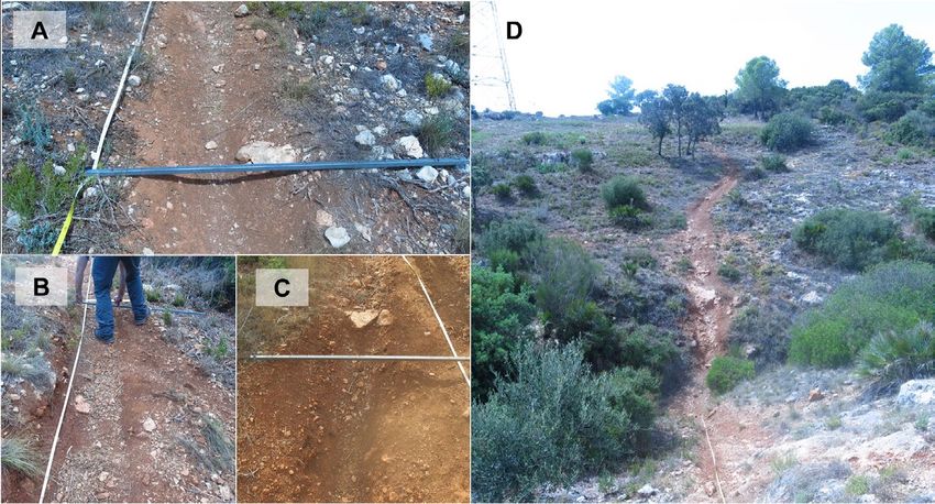
Salesa and Cerdà

        de 2014 y había sido utilizada para cuatro carreras de montaña oficiales y para el
        entrenamiento de corredores locales. Las entrevistas a organizadores y usuarios
        muestran que 1054 corredores pasaron durante los días de competición (4 carreras
        en 4 años) y que durante los 4 años la senda había sido utilizada aproximadamente
        43.800 veces por corredores. Se midió la topografía actual y se calculó la pérdi-
        da de suelo. Los resultados muestran tasas de erosión extremas en las laderas en
        pendiente, con valores máximos en la ladera umbría, alcanzando hasta 180.29 Mg
        ha-1 a-1, mientras que en las secciones llanas las tasas fueron de 107.56 Mg ha-1 a-1
        y en la ladera solana de 128.93 Mg ha-1 a-1. El estudio demuestra que (i) las tasas
        de erosión en sendas de montaña pueden ser fácilmente estimadas midiendo la po-
        sición más profunda de la senda, lo cual permite medidas rápidas y a bajo coste; y
        (ii) se necesitan establecer estrategias de conservación en las nuevas sendas para
        evitar pérdidas de suelo no sostenibles en las montañas mediterráneas debido a
        actividades deportivas como son las carreras de montaña.

        Key words: soil erosion, mountain trails, sustainability, mountain sports, running
        races.
        Palabras clave: erosión del suelo, senda de montaña, sostenibilidad, deportes de
        montaña; carreras.

                                                                         Received: 5 November 2018
                                                                         Accepted: 6 December 2018

*Corresponding author: David Salesa, Soil Erosion and Degradation Research Group.
Department of Geography, Valencia University, Blasco Ibàñez, 28, 46010 Valencia,
Spain. E-mail address: david.salesa@uv.es

1. Introduction

      Running and biking are popular sports that are growing in participants and social
acceptance (Hoffman et al., 2010; Borgers et al., 2015; Knechtle et al., 2015). The use of
mountain areas for sport activities is not new (White and Schreyer, 1981), but during the
last decade it has grown in the number of participants, and therefore the social, economic
and environmental impacts have increased also (Nepal and Way, 2007). The scientific
community is researching the economic and social impact of the use of trails as a leisure
activity (Fix and Loomis, 1997; Bowker et al., 2007; Duglio and Beltramo, 2017) but
much less is known about the biophysical impact of these activities on the environment.
Within the research studies developed in the last decades, the environmental impact of
trails has been assessed in only few regions (Nepal, 2003; Nepal and Nepal, 2004; Beeco
et al., 2013). Furthermore, the awareness of the problem among the general public is low,
although research on the perception of visitors of natural parks is relevant to understand
the problem and find solutions (Sterl et al., 2008).
    Biking, hiking and running are leisure activities that can trigger degradation
processes in natural areas (Thurston and Reader, 2001), although they were created to

310                                     Cuadernos de Investigación Geográfica 45 (1), 2019, pp. 309-331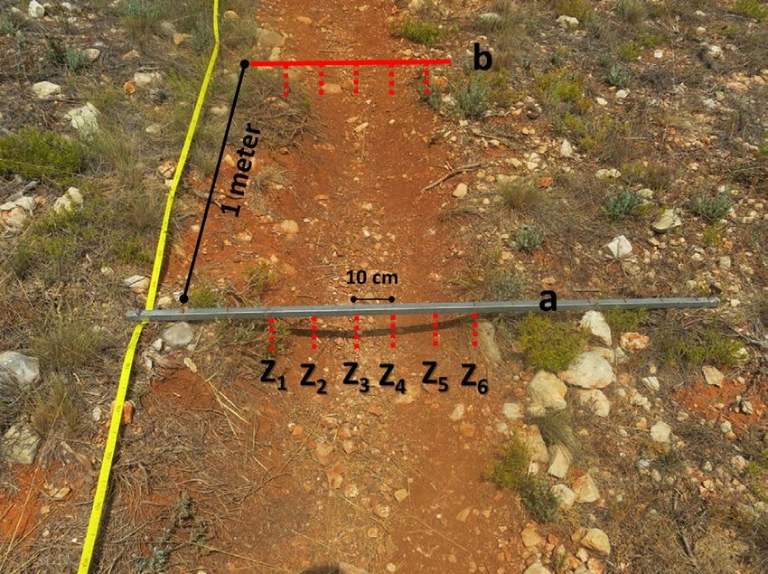
Erosion rates in a running-mountain trail, Iberian Peninsula

preserve natural and high value ecosystems (Jackson, 1987). The awareness of visitors
and managers in natural parks showed an environmental concern related to the outdoor
recreation participation (Jackson, 1986). This is because until recently biking and
running were not considered traditional uses in natural areas as was shown by White
and Schreyer (1981) for National parks in USA. There has been a strong increase in the
number of people that do long runs and bike in natural parks (Knoth et al., 2012). This
triggered a subsequent growth in research in sport activities (Chavez et al., 1993; Rochat
et al., 2017). There is a worldwide growth in the number of trail running practitioners
and many new trails have been opened for this purpose, where runs of sprint trails (11
km), half-marathons (21 km), marathons (42 km) and ultramarathons (100 km or more)
have increasing acceptance. This explains the growth in the research related to the
medical perspective of the trail running (Scheer and Murray, 2011; Burr et al., 2014).
The impact of trails on vegetation and fauna has been found to be negative (Dale and
Weaber, 1974; Comita and Goldsmith, 2008; Newsome and Davies, 2009) but there
is a lack of information about the impact of trails on soil quality, and the key issue to
understand changes in soil quality is the impact on soil erosion due to human trampling,
surface wash, and the interaction of both. There is also a lack of basic data that is needed
to design, management and construction of trails (Symmonds et al., 2000), and for the
advance towards more sustainable management of mountain trails it is necessary to
quantify the soil erosion rates on many locations. In fact, this form of human impact on
the landscape is new as the new trails do not follow the conservation strategies in design
and maintenance as traditional mountain trails constructed by farmers, shepherds and
muleteers do.
      Mountain areas can offer multiple ecosystem services including recreational
services, which contribute positively to human health (Wolf and Wohlfart, 2014;
Brevik et al., 2018). They are an ideal backdrop for many people to practice leisure
and sport activities such as hiking or trail running. This type of activities has been
gaining popularity over the last few years worldwide (Barros et al., 2013; Bodoque et
al., 2017; Ćwiakala et al., 2017) and there are growing numbers of people who seek
to explore new places or create more appealing and challenging routes, particularly
for mountain bikes (Goeft and Alder, 2001), and in recent years more and more for
mountain trail running (Farias-Torbidoni et al., 2018). This anthropogenic pressure on
the environment has effects on ecosystems which implies land degradation due to soil
compaction, vegetation removal and soil erosion. The use of trails by hikers can cause
(i) loss of plant biomass due to trampling, (ii) introduce exotic species and aid their
dispersal, (iii) hinder the movement of wildlife and disturb their habitat, (iv) increase
of human waste in the surroundings; and, (v) alter water quality by increasing turbidity
due to eroded soil ending up in waterways (Leung and Marion, 2000). Moreover, the
main effect of mountain trails is that it triggers land degradation due to the loss of soil
fertility and soil quality, which may ultimately lead to the complete loss of the soil due
to the human trampling induced soil erosion (Morgan and Smith, 1980) and ecosystems
degradation (Burden and Randerson, 1972; Liddle, 1975). Some examples of these
impacts are (i) the loss of soil organic matter and soil moisture, (ii) the increase of bulk
density by compaction, (iii) the detachment and transport of soil particles causing soil

Cuadernos de Investigación Geográfica 45 (1), 2019, pp. 309-331                                             311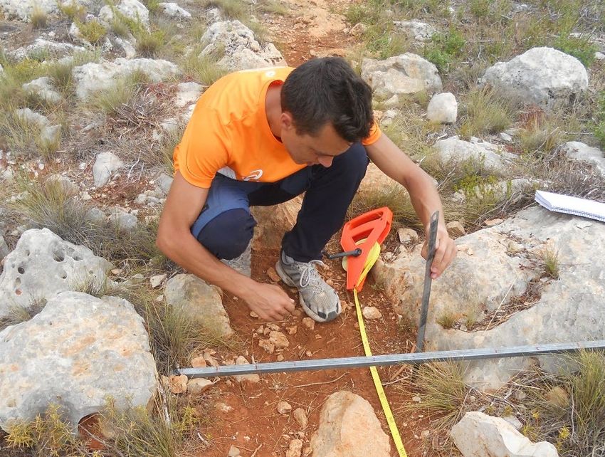
Salesa and Cerdà

erosion and root exposure, (iv) the increase in surface wash; and, (v) alterations in soil
and water chemical properties (Hawkins and Weintraub, 2011). All these impacts are
accentuated if we consider the low rates of soil formation and the limited soil depth,
especially in some areas such as the Mediterranean and mountains terrains where
intensive land use and management has developed over millennia (Butzer, 2005;
González Hidalgo et al., 2007).
     So far, the limited research conducted on trail erosion focussed on trekking trails,
but running trails are at higher risk due to the higher impact of runners as a consequence
of the speed of the runners, and the energy transferred to the soil surface by each step
(Creagh et al., 1998).
     A trail was selected in a Mediterranean range due to the growing recreational
activities in this mountain area and particularly for the purpose of determining erosion
rates in a 4-years old mountain running trail. Therefore, the aims of this paper are: i)
assess soil erosion rates in a Mediterranean trail caused by trail running; ii) determine
the factors that influences the erosion rates; and, iii) develop a new sampling strategy to
reduce the time invested in the field work and allow more measurements.

2. Material and methods

2.1. Study area

      The study area is located in the East of the Iberian Peninsula and is found in a
representative area of the Mediterranean mountains where abandonment took place in
the 1960s, the vegetation is a scrubland and the parent material is limestone (Fig. 1). The
trail selected for this research is located near the municipality of L’Alcúdia de Crespins
and was opened 4 years before the measurements were carried out. Trail runners are the
main users, but also bikers and hikers are regular users of the trail. Within the L’Alcúdia
de Crespins mountain trail we selected 3 sections that are close to each other, but each of
them has different physiographic characteristics such as slope angle and aspect, which
allow to research the soil erosion variability on trails due to those variables. We called
these sections North-facing (35 meters on a northern hillside), South-facing (70 meters in
a southern hillside) and Flat (30 meters on the upper plain). The predominant vegetation in
the study site is scrubland (Globularia alypum, Thymus vulgaris, Rosmarinus officinalis)
with some small dispersed shrubs (Chamaerops humilis, Quercus coccifera, Pistacia
lentiscus). Trees are scarce, mainly represented by Pinus halepensis and Quercus ilex at
the study area but not present in the trail due to the fact that an area without trees was
selected by the trail designer in this part of the trail. The sections of the studied trail
are located under an electric line so the periodic clearing for security reasons results in
a vegetation cover below 1 m in height, with the exception of a bunch of Quercus ilex
trees of approximately 2-m in height. The climate in the study area is temperate with
an average annual temperature of 17ºC; August is the hottest month and January the
coldest. Rainfall is moderately scarce with 426 mm y-1. The driest month is July due to
the summer drought and the wettest is October due to easterly winds coming from the
Mediterranean Sea.

312                                    Cuadernos de Investigación Geográfica 45 (1), 2019, pp. 309-331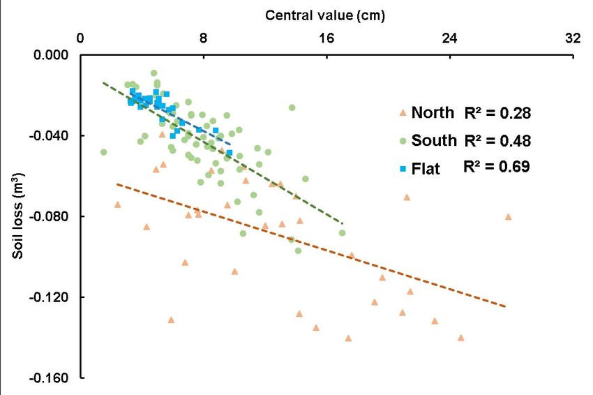
Erosion rates in a running-mountain trail, Iberian Peninsula

Figure 1. L’Alcúdia de Crespins study area in the province of Valencia (Spain). Lower right panel
                     shows the study site with the North and South sections.

     A survey of the trail use by hikers, bikers and runners was done with interviews to the
users and information was collected from the organizers of the “L’Alcúdia de Crespins trail
run” by means of interviews. The interviews (22 users plus 3 organizers) provided information
about how many runners per day used the trail and how many participants yearly use the trail
for competition. In addition, we collected information about the use by bikers and trekkers.

2.2. Measurements of soil erosion

     The three trail sections were surveyed in September 2018 and we calculated soil
erosion rates using the Cross-Sectional-Area (Fig. 2), a widely applied method in trail
erosion research (e.g. Fish et al., 1981; Marion and Olive, 2006; Olive and Marion,
2009; Esque et al., 2016; Tomczyk et al., 2016), which is the most replicable method for
monitoring trail segments (Jewell and Hammitt, 2000). We measured soil depth every
meter of the trail and 10 cm along each cross-section and employed a metal bar which
we placed over the edges of the trail considering that it was the original ground surface
before the use of the trail (Webb et al., 1978). In each metre we registered the slope
angle in the centre of the trail and the rock fragment cover and rock embedded was
quantitatively estimated in percentage. From depth measurements in cm, the erosion
rates (in cm3) of the trail were calculated with the following equation:

                                                                                                         (1)

Cuadernos de Investigación Geográfica 45 (1), 2019, pp. 309-331                                             313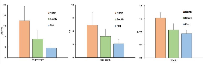
Salesa and Cerdà

      where Za represents each soil depth measurement from the metal bar at measurement
point a and Zb each soil depth measurement on the following point measurement (Fig. 3).
This calculation was repeated for each metre of the trail and by adding all the calculations,
the final volume of soil loss was obtained. With the trail soil samples collected, the soil
density was determined in the laboratory to finally obtain the soil erosion rate in Mg ha-1 y-1.

                    Figure 2. Measuring soil depth in the L’Alcúdia Mountain Trail
                   using the Cross-Sectional-Method to calculate soil erosion rates.

Figure 3. Schematic view of soil depth measurements on the trail. Z represents the height between
 the metal bar and the ground surface (i.e. the soil lowering) and the lower case letters show the
                         measurement points every meter along the trail.

314                                          Cuadernos de Investigación Geográfica 45 (1), 2019, pp. 309-331
Erosion rates in a running-mountain trail, Iberian Peninsula
3. Results
3.1. Runners’ use of the L’Alcúdia trail
The interviews with the organizers of races and individual local runners in October
2018 have shown that there is a higher density of runners during the competition events.
The trail was opened in September 2014, and in 2015 (25/1/2015) the first trail running
competition took place with 401 participants. In 2016 (31/1/2016) the number of runners
dropped to 169 and in 2017 (26/3/2017) and 2018 (22/4/2018) the participants’ number
reached 231 and 253, respectively. The interviews with the runners that use the trail
regularly show that on average 30 people per day use the trail for running and 5 for
trekking. The interviews showed that the use of the trails varies from 5 to 50 users per
day. Bikers are rare in comparison to runners as they are mainly present in the weekends
and on average 3 bikes use the trail daily. Those numbers show that in the last four
years approximately 1054 runners used the trail for a competition. However, the daily
use for training sums up to a total of 43800 runners’, 4380 bikers’ and 7300 trekkers’
passes. Those numbers are based on the calculations of the runners that use the trail,
which is the only source of information as there are no official data about the use and
the governmental organizations are not involved in the maintenance of the trails or the
organization of the competitions.
3.2. Soil erosion
Table 1 shows the descriptive results from the measurements carried out at the
studied trails. North-facing section shows the highest slope values (20.97º) and it
contains the widest trail of the three sections studied (1.23 m). The north-facing trail
section presents a low rock fragment covers in comparison to the south-facing section
(17.08% and 26.48% respectively) whereas the flat trail section shows the lowest
value of rock fragment cover (2.58%). Furthermore, in the South-facing section we
have come across 7 occasions (out of 70) in which the soil lowering was 0 due to the
fact that the trail consisted of a rock outcrop while in the North-facing section this
was measured twice (out of 35). The total exposure of rock outcrops means that the
whole soil profile has been removed and the erosion cannot progress more in depth.
Therefore, although the soil losses were registered as 0 (null) in fact the soil erosion
already removed the whole soil before the trail was established. Figure 4 showed the
basic properties of the 3 studied trail sections: slope angle, soil lowering and trail
width. It can be observed how these 3 results from the L’Alcúdia de Crespins trail
have the same pattern for the 3 sections we have analysed. The North-facing section
presents the highest values of slope angle, soil erosion and trail width. The South-
facing section has middle values and the Flat section exhibits the lowest results of
slope angle, soil erosion and trail width. As a result, soil erosion volume calculations
of the 3 sections are contrasted (Fig. 5). The North-facing section trail shows the most
severe soil loss values and has a high variability. In contrast, the Flat section has low
soil loss values and is very homogeneous.
Cuadernos de Investigación Geográfica 45 (1), 2019, pp. 309-331 315Salesa and Cerdà
Table 1. Topographical characteristics of the three study trails. The standard deviation is
indicated in parentheses.
Topographical measurements North South Flat
Length (m) 35 70 30
Average width (m) 1.23 (0.18) 0.86 (0.19) 0.75 (0.11)
Average slope (º) 20.97 (8.08) 10.61 (5.10) 5.48 (3.25)
Age (y) 4 4 4
Area (ha) 0.004 0.006 0.002
Average parent rock (%) 17.08 (27.03) 26.48 (30.64) 2.58 (4.26)
Lowest elevation (m.a.s.l) 255.17 254.56 268.83
Highest elevation (m.a.s.l.) 264.49 267.4 271.08
Change in elevation (m/linear m) 0.27 0.18 0.08
Figure 4. Basic characteristics of the 3 sections of the trail studied. The standard deviation is
indicated using bars.
Figure 5. Boxplot diagram for the soil lost calculations of the 3 sections of the trail (median
values, average values (with a cross), upper and lower quartiles and outliers).
316 Cuadernos de Investigación Geográfica 45 (1), 2019, pp. 309-331Erosion rates in a running-mountain trail, Iberian Peninsula
Table 2 shows the results of the calculations made and the topographical
changes in the L’Alcúdia de Crespins trail. These results show very significant
soil lowering rates, reaching up to 1.85 cm of soil lost each year in the North-
facing section. Even though it is a much lower value, soil lost in Flat section is still
considerable (0.78 cm y-1). Whereas this is a trail that has only been in use for four
years, the resulting soil erosion rates on the trail surface are totally unsustainable
with values ranging between 107.56 and 180.29 Mg ha-1 y-1 for the Flat and North-
facing sections respectively, in other words, for every 100 meters of trail, between
0.78 and 2.28 Mg per year are lost.
Table 2. Topographical changes and soil erosion rates in the three study trails. The standard
deviation is indicated in parentheses.
Topographical changes North South Flat
Average soil lowering (cm) 7.40 (2.84) 4.80 (1.72) 3.13 (1.00)
Average soil lowering (cmy ) -1
1.85 1.20 0.78
Average of highest depth (cm) 15.62 (5.89) 9.40 (3.22) 5.45 (1.52)
Average of soil depth in the centre
12.85 (6.53) 8.09 (3.01) 5.08 (1.55)
(cm)
Total soil lost (m3) 3.03 2.79 0.82
Average soil lost (m3 m-1) 0.09 (0.03) 0.04 (0.02) 0.03 (0.01)
Soil density (Mg m3) 1.02 (0.12) 1.11 (0.04) 1.18 (0.07)
Soil erosion rate (Mg ha-1 y-1) 180.29 128.93 107.56
We have also found that a relationship exists between the soil lowering value in
the centre of the trail and the calculated soil loss (Fig. 6), especially in the flat section
(R2=0.69). This can be attributed to the strong correlation that exists between erosion
value in the middle of the trail and the maximum erosion value at each measurement point
(Fig. 7), which in turn, has a significant impact on the erosion rate obtained. Considering
this, we can obtain an average of 78.81% of total erosion calculated by measuring only
the trail width and the depth of the trail in the middle of the trail (Fig. 8). This finding is
of great help for future research as this creates the opportunity to increase the surveyed
area with little loss of accuracy.
We have observed a different pattern of soil lowering values depending on the
slope angle in which they are found (Fig. 9). At lower slope angle values (0º-5º) soil
loss tends to decrease. In areas with intermediate slope values (6º-23º), there is a
growing trend of greater soil loss as the angle of the trail increases. At steep slope
values (24º-43º), the soil lowering values do not follow any trend and the results show
large variability.
Cuadernos de Investigación Geográfica 45 (1), 2019, pp. 309-331 317Salesa and Cerdà
Figure 6. Linear adjustment of soil depth values in the centre of the trail and its corresponding
calculated soil erosion value for the 3 trail sections.
Figure 7. Linear adjustment between the central depth in the trail and the maximum depth in
each measurement point.
318 Cuadernos de Investigación Geográfica 45 (1), 2019, pp. 309-331Erosion rates in a running-mountain trail, Iberian Peninsula
Figure 8. Erosion values estimated by the trail width and depth in the centre of the trail relative
to the total erosion calculated with equation (1). The estimated percentage of erosion with
respect to the real value reaches 78.81%.
Figure 9. Measured soil depth values grouped into 3 slope angle categories.
Cuadernos de Investigación Geográfica 45 (1), 2019, pp. 309-331 319Salesa and Cerdà
4. Discussion
The research on soil erosion should be updated and improved in the next decades
(García-Ruiz et al., 2017). Soil erosion has been researched in different land uses, but
mainly in agriculture land (García-Ruiz, 2010; Antoneli et al., 2018; Cerdà et al., 2018;
Rodrigo Comino et al., 2018a; 2018b). On forest ecosystems the impact of fire has been
mainly research in the Mediterranean ecosystems (Inbar et al., 1998; Fox et al., 2006;
Di Prima et al., 2018) but little is known about how human trampling in natural areas
affect the soil erosion processes. Research on soil erosion has been developed since the
beginning of the 20th century (Smith, 1914; Munns, 1920) in USA, but trail erosion is a
new issue, both on global scale as well as on Mediterranean regional scale. This is due
to the fact that mountain areas in developed countries were abandoned and therefore the
traditional trails were abandoned too. The abandonment triggered the vegetation cover
to recover; the trails were lost and soil erosion was controlled and reduced to the lowest
rates. Those changes reduced the connectivity of the flows such as in agriculture land has
been demonstrated by Masselink et al. (2017a) and should be more researched in natural
areas to understand the soil erosion processes and rates (Keesstra et al., 2018a). Leisure
and sports are bringing human presence back to the mountains, and trail running can be
the cause of high erosion rates as we found at the running trail of L’Alcúdia de Crespins
with values that are two orders of magnitude higher than what is considered sustainable
by the scientific community (Smith and Stamey, 1965). The sport activity can change
the connectivity of the systems such as other disciplines have shown (Masselink et al.,
2017b; Turnbull et al., 2018) and we still know little about how this can change the
natural system after a shift (Lana-Renault et al., 2018; Lasanta et al., 2018).
The agriculture abandonment was fast in the Mediterranean landscapes where the
Mountainous areas were abandoned suddenly in the 1950s and 1960s (Lasanta-Martínez et
al., 2005; Serra et al., 2008), which caused profound environmental changes (García-Ruiz
and Lana-Renault, 2011). The return of people to the mountains for leisure activities, such
as trekking has become increasingly popular since the 1970’s, but in the 1990s mountain
biking arrived and in the last decade trail running became one of the favourite activities for
the runners that use to run in urban areas. This increase in trail running results in the creation
of new routes and because runners prefer to use trails on steep slopes, the highest impact of
trail running in terms of erosion is found on these steep slopes but there are few evidences and
proves of this. The fact that there is little information on soil erosion in running and biking
trails makes it urgent to create a knowledge base to be able to achieve the goal of sustainable
management of existing trails and design of the new trails with proper maintenance. This
paper surveys the impact of trail running on soil erosion as a first step to understand the
processes and factors that are important, to improve the survey strategies and finally to
contribute with information to design restoration and rehabilitation programs and improve
the design of a trail for running.
The research on erosion in mountain trails and the effects they cause began to be studied
later in the 1970’s (Willard and Marr, 1971) in the USA. Willard and Marr (1971) studied
the effect of hiking on the vegetation of the alpine tundra in Colorado and the difficulties of
recovering from trampling and Helgath (1975), also in USA, continued seeking to determine
320 Cuadernos de Investigación Geográfica 45 (1), 2019, pp. 309-331Erosion rates in a running-mountain trail, Iberian Peninsula
the influence of different environmental factors in trail degradation. USA has continued
leading the investigation at a global scale in the following years, both in the USA and in
other countries where trail erosion has been studied by American colleagues (e.g. Farrell and
Marion, 2001a; Wallin and Harden, 1996). Those studies were focussed on trails used for
trekking and a need of information from trail running impact is necessary.
The Mediterranean areas show little research on the trail erosion. The pioneer research
was carried out by Bodoque et al. (2005). Pelfini and Santilli (2006) studied the trail erosion
in the Italian Alps. And little research was developed afterwards (López-Vicente et al.,
2013; Tarolli et al., 2013). Then, there is little data about trail erosion in the mountains of the
Mediterranean basin, and no data available about trail running erosion at all.
Our research demonstrates that soil erosion in running trails results in extremely
high erosion rates which are higher than the ones found after forest fires (Shakesby,
2011), bare agriculture soils (García-Ruiz, 2010; Keesstra et al., 2014) and in extreme
rainfall events (Martínez-Casasnovas et al., 2002) in Mediterranean type ecosystems.
We found that the soil losses in this trail are on average 138.92 Mg ha-1 y-1 (14.2 Mg
y-1 km-1), thereby, our results show that trail erosion is totally unsustainable, especially
in semi-arid regions where soil formation rates are very low. The sustainable or non-
sustainable use of trails should be considered according to the soil development, which
depends on their location. In the Mediterranean area, the frequent use of mountain trails
may have a severe effect on the degradation of the soil in an area, since these shallow
soils are subjected to intense trampling, and high intensity rainfall events.
The soil erosion in the running trail of L’Alcúdia de Crespins has shown values that
are similar to other trails which were not recently opened or were used only for trekking.
The trails researched by other scientists such as Stull et al. (1979) showed values of 540
Mg ha-1 y-1 or Johnson and Smith (1983) with 632 Mg ha-1 y-1. The highest soil losses
were found by Sack and da Luz (2003) with 2090 Mg ha-1 y-1. Other authors found values
lower, such as Kidd et al. (2014) with 20.5 Mg ha-1 y-1 and Ramos-Scharrón et al. (2014)
with 81 Mg ha-1 y-1. This data is confirmed by the values found in the Mediterranean
mountains with values of 170 Mg ha-1 y-1 found by Bodoque et al. (2005) with 151.3 Mg
ha-1 y-1 under trekking and biking conditions; and by Bodoque et al. (2017) under hiking
conditions. Similar results were registered by López-Vicente and Navas (2009) with
306.3 Mg ha-1 y-1, and López-Vicente et al., (2013) with 6.1 Mg ha-1 y-1. Data coming
from different continents show that trail erosion rates are very variable from one location
to another, and that this is found also in Mediterranean trails. Our results are in the range
of what was found until now and the use as a running trail did not show any special
response from the erosional point of view.
The spatial distribution of the soil erosion in the researched trails depends on the
physiographic characteristics of the sites and we distinguished between North-facing
South-facing and Flat areas. Aspect turned out to be a key factor as vegetation in the
trails is negligible, unlike other land uses (Feng et al., 2018). Our results show that
the soil erosion rates were higher in the north-facing slope, but the scientific literature
shows the contrary. The pioneer research of Hughes (1972) shows that the aspect is a
relevant variable to explain erosion in the loess area of the Banks Peninsula in New
Cuadernos de Investigación Geográfica 45 (1), 2019, pp. 309-331 321Salesa and Cerdà
Zealand. Cerdà (1998) found that the soil erosion is usually higher in the south-facing
slope due to lower vegetation cover. And similar findings were highlighted by Agassi
et al. (1990), Agassi and Ben-Hur (1991), Sidle et al. (1993), van Breda Weaver (1991)
and Bojie et al. (1995). However, at the trail running of L’Alcúdia de Crespins the soil
erosion is higher on the north-facing slopes, and this can be explained by the fact that
trails behave differently from normal soils due to the lack of vegetation. The north-facing
slopes normally have a higher vegetation cover and deeper soils, as the climate is more
temperate and this allows for a more favourable condition to form soil (Buol et al., 2011;
Olivero and Hix, 1998). The south-facing slopes, on the other hand, suffer from hydric
stress and the plant cover is lower and soil formation (soil depth) repressed (Måren et al.,
2015). This situation is well known in different ecosystems (Phillips et al., 2008; Begum
et al., 2010) and it is also true for Mediterranean type ecosystems (Kutiel, 1992; Kutiel
and Lavee, 1999; Sternberg and Shoshany, 2001; Sidari et al., 2008). Aspect arises has
also been found to be a key factor on soil and soil erosion distribution after a wildfire
(Marques and Mora, 1992; Cerdà et al., 1995; Pausas et al., 1999). In the L’Alcúdia de
Crespins running trail, the high erosion rates in the north-facing trail section is due to
the deeper soils that are present there, which simply means that there is more soil to be
eroded. This situation explains that the running trail almost lost all its soil after 4 years
of use, which is confirmed by the high amount of rock outcrops (Fig. 10). Therefore, it
can be concluded that mountain trail running contributes to removing almost all soil in
a mountainous area with shallow soils. And on locations where more soil is present the
impact is higher: which in this case is the north-facing slope. This does not occur when
a soil is covered with vegetation as the above-mentioned literature showed, because in
these areas the vegetation cover is the key determining parameter (Kirchhoff et al., 2017).
Figure 10. View of the L’Alcúdia de Crespins trail. A, detail of the measurement in the north
facing section; B, view of the measurement in the north-facing section; C, Detail of the depth of
soil lowering in the south-facing section; and, D, View of the north facing slope from the South-
facing section.
322 Cuadernos de Investigación Geográfica 45 (1), 2019, pp. 309-331Erosion rates in a running-mountain trail, Iberian Peninsula
The two key factors for soil erosion on trails are the slope angle and the width of
the trail. The link between slope angle, soil loss and trail width has been well studied
previously by the scientific community. Trail widening is related with flat areas mainly
caused by the lack of runoff which often leads to water accumulations and muddiness
that result in users trying to avoid the puddle and trampling the vegetation along the trail
edges (Monz et al., 2010). However, our results do not support this statement probably
caused by the strong influence of slope angle in the steep Mediterranean slopes. Bratton
et al. (1979) obtained that the slope of the trail is the most important physical factor
related to the erosion rate. Greater erosion on steeper trails can be attributed to the greater
velocity of runoff, which causes more soil particle detachment, and in addition, protective
elements such as stones are easily transported (Farrell and Marion, 2001b). Cao et al.
(2014) also verified that slope angle is a factor influencing rill erosion in different road
types, including trails. In the L’Alcúdia de Crespins trail the low precipitation amount at
the Mediterranean areas (500 mm y-1) reduces the effect of the slope angle as the runoff
production is lower than in regions with higher rainfall amount.
A further component that has an influence on trail characteristics is the angle
formed by the trail compared to the maximum slope angle line of the hillside. This
feature is known as trail alignment and it can cause a major influence on the soil loss
that takes place (Olive and Marion, 2009). According to Marion and Leung (2004), the
main specification to reduce soil erosion rates is to keep the trail slope angle below
12% and the slope alignment angle between 45º and 90º to allow water drainage and
avoid incision. None of these two properties are fulfilled in our studied North and South
sections. Wimpey and Marion (2010) found that fall-alignment trails (low-level trail
alignments) are correlated with wider trails due to the superficial water flow that follows
the maximum slope angle, which is encouraged by the trail that functions as a drainage
line. The cumulative effect of the slope angle and trail alignment was demonstrated by
Marion and Olive (2006) who obtained a greater influence of the slope angle as the trail
alignment was reduced.
In the figure 9 we have found different trend patterns of erosion rates with the
increase of slope angle. At gentle slopes, a slight increase in the slope angle of the trail
reduces the soil loss. This may be caused by the increased mobility of soil particles
from surrounding places. As a result, these soil particles are deposited on the trail, as
the slope gradient of the trail does not allow them to move further. As the slope angle
further increases, the soil loss again becomes higher due to a combined effect of gravity,
an enhanced water erosive power and transport capacity and soil particle detachment.
Finally, on the steepest slopes no clear trend can be found. The great variability in
the erosion values on the steepest slopes is consistent with the results of Randall and
Newsome (2008), who found an increasing trend in erosion rates with higher slopes but
this trend is no longer valid when the slopes become too high.
It is clear that the pathway trail users take on the trail can influence soil erosion
along the trail due to the removal of the vegetation. Plants inside and on trail boundaries
can reduce erosion and a forest canopy can reduce rainfall runoff by up to 10% (Goeft
and Alder, 2001) and even more, vegetation can constrain traffic in a stable tread width
Cuadernos de Investigación Geográfica 45 (1), 2019, pp. 309-331 323Salesa and Cerdà
(Marion and Leung, 2004). Therefore, we think that vegetation should be an essential
feature in the process of designing new trails. Another distinctive attribute of L’Alcúdia
de Crespins Trail is the time it has been open. As we have already proved, a large amount
of soil has been lost in just over 4 years. Nevertheless, some authors report that the higher
soil erosion rates on trails occur shortly after their opening or construction (Deluca
et al., 1998; Nepal, 2003; Ramos-Scharrón et al., 2014), so we expect these erosion
rates to gradually stabilize as the soil available to be eroded decrease, but to verify this
will be upon the improvement of the knowledge. This will contribute to achieve the
sustainability (Keesstra et al., 2018b).
5. Conclusions
The growing interest in outdoor sport activities is common and mountain trail
running is getting more popular. Our measurements determined soil erosion in the
L’Alcúdia de Crespins (eastern Spain) running trail to be very high, with an average
of 1.28 cm y-1, which results in average erosion rates of 138.92 Mg ha-1 y-1 on the trail
surface. We found that north-facing slopes have the highest erosion rates as this is where
there is more soil available to be eroded. We also found that slope angle increases the soil
erosion rates and that the comparison with other researches show that the erosion rates
are as high as other scientists found in other trails. Our calculations show that 4 years is
enough to increase the number of rock outcrops and result in most of the soil on the trail
to be lost. There is a need to apply rehabilitation strategies on running trails and design
new trails with erosion prevention measures, to avoid that most of the soil is lost after 4
years such as we measured in the L’Alcúdia de Crespins trail.
Acknowledgements
This research is one of the results of the RECARE-FP7 project (ENV.2013.6.2-4,
http://recare-project.eu). We thanks the runners that use the L’Alcúdia de Crespins trail
for their help to quantify the use of the trail by the runners’ community. Mauro Ponsoda
contributed to the field measurements.
References
Agassi, M., Ben-Hur, M. 1991. Effect of slope length, aspect and phosphogypsum on runoff and
erosion from steep slopes. Soil Research 29 (2), 197-207. https://doi.org/10.1071/SR9910197.
Agassi, M., Morin, J., Shainberg, I. 1990. Slope, aspect, and phosphogypsum effects on runoff and
erosion. Soil Science Society of America Journal 54 (4), 1102-1106. https://doi.org/10.2136/
sssaj1990.03615995005400040030x.
Antoneli, V., Rebinski, E.A., Bednarz, J.A., Rodrigo-Comino, J., Keesstra, S.D., Cerdà, A., Pulido
Fernández, M. 2018. Soil Erosion Induced by the Introduction of New Pasture Species
in a Faxinal Farm of Southern Brazil. Geosciences 8(5), 166. https://doi.org/10.3390/
geosciences8050166.
Barros, A., Gonnet, J., Pickering, C. 2013. Impacts of informal trails on vegetation and soils in the
highest protected area in the Southern Hemisphere. Journal of Environmental Management
127, 50-60. https://doi.org/10.1016/j.jenvman.2013.04.030.
324 Cuadernos de Investigación Geográfica 45 (1), 2019, pp. 309-331Erosion rates in a running-mountain trail, Iberian Peninsula
Beeco, J.A., Hallo, J.C., Giumetti, G.W. 2013. The importance of spatial nested data in understanding
the relationship between visitor use and landscape impacts. Applied Geography 45, 147-157.
https://doi.org/10.1016/j.apgeog.2013.09.001.
Begum, F., Bajracharya, R.M., Sharma, S., Sitaula, B.K. 2010. Influence of slope aspect on soil
physico-chemical and biological properties in the mid hills of central Nepal. International
Journal of Sustainable Development & World Ecology 17 (5), 438-443. https://doi.org/10.10
80/13504509.2010.499034.
Bodoque, J.M., Ballesteros-Cánovas, J.A., Rubiales, J.M., Perucha, M.Á., Nadal-Romero, E.,
Stoffel, M. 2017. Quantifying Soil Erosion from Hiking Trail in a Protected Natural Area
in the Spanish Pyrenees. Land Degradation & Development 28, 2255-2267. https://doi.
org/10.1002/ldr.2755.
Bodoque, J.M., Díez-Herrero, A., Martín-Duque, J.F., Rubiales, J.M., Godfrey, A., Pedraza,
J., Carrasco, R.M., Sanz, M.A. 2005. Sheet erosion rates determined by using
dendrogeomorphological analysis of exposed tree roots: two examples from Central Spain.
Catena 64 (1), 81-102. https://doi.org/10.1016/j.catena.2005.08.002.
Bojie, F., Xilin, W., Gulinck, H. 1995. Soil erosion types in the Loess Hill and Gully area of China.
Journal of Environmental Science and Engineering 7, 266-272. https://doi.org/10.1002/
ldr.3400050105.
Borgers, J., Thibaut, E., Vandermeerschen, H., Vanreusel, B., Vos, S., Scheerder, J. 2015.
Sports participation styles revisited: A time-trend study in Belgium from the 1970s to
the 2000s. International Review for the Sociology of Sport 50 (1), 45-63. https://doi.
org/10.1177/1012690212470823.
Bowker, J.M., Bergstrom, J.C., Gill, J. 2007. Estimating the economic value and impacts of recreational
trails: a case study of the Virginia Creeper Rail Trail. Tourism Economics 13 (2), 241-260.
Bratton, S.P., Hickler, M.G., Graves, J.H. 1979. Trail erosion patterns in Great Smoky Mountains
National Park. Environmental Management 3 (5), 431-445. https://doi.org/10.1007/
BF01866582.
Brevik, E.C., Pereg, L., Steffan, J.J., Burgess, L.C. 2018. Soil ecosystem services and human health.
Current Opinion in Environmental Science & Health 5, 87-92. https://doi.org/10.1016/j.
coesh.2018.07.003.
Buol, S.W., Southard, R.J., Graham, R.C., McDaniel, P.A. 2011. Soil genesis and classification.
John Wiley & Sons.
Burden, R.F., Randerson, P.F. 1972. Quantitative studies of the effects of human trampling on
vegetation as an aid to the management of semi-natural areas. Journal of Applied Ecology 9
(2), 439-457. https://doi.org/10.2307/2402445.
Burr, J.F., Drury, C.T., Phillips, A.A., Ivey, A., Ku, J., Warburton, D.E. 2014. Long-term ultra-
marathon running and arterial compliance. Journal of Science and Medicine in Sport 17 (3),
322-325. https://doi.org/10.1016/j.jsams.2013.04.018.
Butzer, K.W. 2005. Environmental history in the Mediterranean world: cross-disciplinary
investigation of cause-and-effect for degradation and soil erosion. Journal of Archaeological
Science 32 (12), 1773-1800. https://doi.org/10.1016/j.jas.2005.06.001.
Cao, L., Zhang, K., Liang, Y. 2014. Factors affecting rill erosion of unpaved loess roads in China.
Earth Surface Processes and Landforms 39 (13), 1812-1821. https://doi.org/10.1002/esp.3569.
Cerdà, A. 1998. The influence of aspect and vegetation on seasonal changes in erosion under
rainfall simulation on a clay soil in Spain. Canadian Journal of Soil Science 78 (2), 321-330.
https://doi.org/10.4141/S97-060.
Cerdà, A., Imeson, A.C., Calvo, A. 1995. Fire and aspect induced differences on the erodibility and
hydrology of soils at La Costera, Valencia, southeast Spain. Catena 24 (4), 289-304. https://
doi.org/10.1016/0341-8162(95)00031-2.
Cuadernos de Investigación Geográfica 45 (1), 2019, pp. 309-331 325Salesa and Cerdà
Cerdà, A., Rodrigo-Comino, J., Giménez-Morera, A., Keesstra, S. D. 2018. Hydrological and
erosional impact and farmer’s perception on catch crops and weeds in citrus organic farming
in Canyoles river watershed, Eastern Spain. Agriculture, Ecosystems & Environment 258,
49-58. https://doi.org/10.1016/j.agee.2018.02.015.
Chavez, D.J., Winter, P.L., Baas, J.M. 1993. Recreational mountain biking: A management
perspective. Journal of Park and Recreation Administration 11 (3), 29-36.
Comita, L.S., Goldsmith, G.R. 2008. Impact of research trails on seedling dynamics in a tropical
forest. Biotropica 40(2), 251-254. https://doi.org/10.1017/S0266467405002890.
Creagh, U., Reilly, T., Lees, A. 1998. Kinematics of running on ‘off-road’ terrain. Ergonomics 41
(7), 1029-1033. https://doi.org/10.1080/001401398186577.
Ćwiąkała, P., Kocierz, R., Puniach, E., Nędzka, M., Mamczarz, K., Niewiem, W., Wiącek, P.
2017. Assessment of the Possibility of Using Unmanned Aerial Vehicles (UAVs) for the
Documentation of Hiking Trails in Alpine Areas. Sensors 18 (1), 81. https://doi.org/10.3390/
s18010081.
Dale, D., Weaver, T. 1974. Trampling effects on vegetation of the trail corridors of north
Rocky Mountain forests. Journal of Applied Ecology 11 (2), 767-772. https://doi.
org/10.2307/2402226.
Deluca, T.H., Patterson, L.V., Freimund, W.A., Cole, D.N. 1998. Influence of llamas, horses,
and hikers on soil erosion from established recreation trails in western Montana, USA.
Environmental Management 22 (2), 255-262. https://doi.org/10.1007/s002679900101.
Di Prima, S., Lassabatere, L., Rodrigo-Comino, J., Marrosu, R., Pulido, M., Angulo-Jaramillo, R.,
Pirastru, M. 2018. Comparing transient and steady-state analysis of single-ring infiltrometer
data for an abandoned field affected by fire in Eastern Spain. Water 10 (4), 514. https://doi.
org/10.3390/w10040514.
Duglio, S., Beltramo, R. 2017. Estimating the economic impacts of a small-scale sport tourism
event: The case of the Italo-Swiss mountain trail CollonTrek. Sustainability 9 (3), 343.
https://doi.org/10.3390/su9030343.
Esque, T.C., Inman, R., Nussear, K.E., Webb, R.H., Girard, M.M., DeGayner, J. 2016. Comparison
of Methods to Monitor the Distribution and Impacts of Unauthorized Travel Routes in a
Border Park. Natural Areas Journal 36 (3), 248-258. https://doi.org/10.3375/043.036.0305.
Farias-Torbidoni, E.I., Urbaneja, J.S., Ferrer, R., Dorado, V. 2018. Carreras de trail running y
marchas por montaña en España. Número, evolución e incidencia sobre la Red Natura 2000.
Pirineos 173, 9-18.
Farrell, T.A., Marion, J.L. 2001. Trail impacts and trail impact management related to visitation at
Torres del Paine National Park, Chile. Leisure/Loisir 26 (1-2), 31-59. https://doi.org/10.108
0/14927713.2001.9649928.
Farrell, T.A., Marion, J.L. 2001. Identifying and assessing ecotourism visitor impacts at eight
protected areas in Costa Rica and Belize. Environmental Conservation 28 (3), 215-225.
https://doi.org/10.1017/S0376892901000224.
Feng, T., Wei, W., Chen, L., Rodrigo-Comino, J., Die, C., Feng, X., Yu, Y. 2018. Assessment
of the impact of different vegetation patterns on soil erosion processes on semiarid loess
slopes. Earth Surface Processes and Landforms 43 (9), 1860-1870. https://doi.org/10.1002/
esp.4361.
Fish, E.B., Brothers, G.L., Lewis, R.B. 1981. Erosional impacts of trails in Guadalupe Mountains
National Park, Texas. Landscape Planning 8 (4), 387-398. https://doi.org/10.1016/0304-
3924(81)90004-6.
Fix, P., Loomis, J. 1997. The economic benefits of mountain biking at one of its meccas: An
application of the travel cost method to mountain biking in Moab, Utah. Journal of Leisure
Research 29 (3), 342-352. https://doi.org/10.1080/00222216.1997.11949800.
326 Cuadernos de Investigación Geográfica 45 (1), 2019, pp. 309-331Erosion rates in a running-mountain trail, Iberian Peninsula
Fox, D., Berolo, W., Carrega, P., Darboux, F. 2006. Mapping erosion risk and selecting sites for
simple erosion control measures after a forest fire in Mediterranean France. Earth Surface
Processes and Landforms 31 (5), 606-621. https://doi.org/10.1002/esp.1346.
García-Ruiz, J.M. 2010. The effects of land uses on soil erosion in Spain: a review. Catena 81 (1),
1-11. https://doi.org/10.1016/j.catena.2010.01.001.
García-Ruiz, J.M., Lana-Renault, N. 2011. Hydrological and erosive consequences of farmland
abandonment in Europe, with special reference to the Mediterranean region–a review.
Agriculture, Ecosystems & Environment 140 (3-4), 317-338. https://doi.org/10.1016/j.
agee.2011.01.003.
García-Ruiz, J.M., Beguería, S., Lana-Renault, N., Nadal-Romero, E., Cerdà, A. 2017. Ongoing
and emerging questions in water erosion studies. Land Degradation & Development 28 (1),
5-21. https://doi.org/10.1002/ldr.2641.
Goeft, U., Alder, J. 2001. Sustainable mountain biking: a case study from the southwest
of Western Australia. Journal of Sustainable Tourism 9 (3), 193-211. https://doi.
org/10.1080/09669580108667398.
González-Hidalgo, J.C., Peña-Monné, J.L., de Luis, M. 2007. A review of daily soil erosion in Western
Mediterranean areas. Catena 71 (2), 193-199. https://doi.org/10.1016/j.catena.2007.03.005.
Hawkins, J., Weintraub, M.N. 2011. The Effect of Trails on Soil in the Oak Openings of Northwest
Ohio. Natural Areas Journal 31 (4), 391-399. https://doi.org/10.3375/043.031.0409.
Helgath, S.F. 1975. Trail deterioration in the Selway-Bitterroot wilderness (Research Note INT
193). USDA Forest Service. 15 pp.
Hoffman, M.D., Ong, J.C., Wang, G. 2010. Historical analysis of participation in 161 km
ultramarathons in North America. The International Journal of the History of Sport 27 (11),
1877-1891. https://doi.org/10.1080/09523367.2010.494385.
Hughes, P.J. 1972. Slope aspect and tunnel erosion in the loess of Banks Peninsula, New Zealand.
Journal of Hydrology (New Zealand) 11 (2), 94-98.
Inbar, M., Tamir, M.I., Wittenberg, L. 1998. Runoff and erosion processes after a forest fire in
Mount Carmel, a Mediterranean area. Geomorphology 24 (1), 17-33. https://doi.org/10.1016/
S0169-555X(97)00098-6.
Jackson, E.L. 1986. Outdoor recreation participation and attitudes to the environment. Leisure
Studies 5 (1), 1-23. https://doi.org/10.1080/02614368600390011.
Jackson, E.L. 1987. Outdoor recreation participation and views on resource development and
preservation. Leisure Sciences 9 (4), 235-250. https://doi.org/10.1080/01490408709512165.
Jewell, M.C., Hammitt, W.E. 2000. Assessing soil erosion on trails: a comparison of techniques.
In: D.N. Cole, F.S. McCool, T.W. Borrie, J. O’Loughlin (Comps.), Wilderness Science in
a time of change Conference- Volume 5: Wilderness ecosystems, threats, and management.
USDA Forest Service. pp. 133-140.
Johnson, C.W., Smith, J.P. 1983. Soil loss caused by off-road vehicle use on steep slopes.
Transactions of the ASAE 26 (2), 402-405.
Keesstra, S.D., Temme, A.J.A.M., Schoorl, J.M., Visser, S.M. 2014. Evaluating the hydrological
component of the new catchment-scale sediment delivery model LAPSUS-D. Geomorphology
212, 97-107. https://doi.org/10.1016/j.geomorph.2013.04.021.
Keesstra, S., Nunes, J.P., Saco, P., Parsons, T., Poeppl, R., Masselink, R., Cerdà, A. 2018. The way
forward: Can connectivity be useful to design better measuring and modelling schemes for
water and sediment dynamics? Science of the Total Environment 644, 1557-1572. https://doi.
org/10.1016/j.scitotenv.2018.06.342.
Keesstra, S., Mol, G., de Leeuw, J., Okx, J., de Cleen, M., Visser, S. 2018. Soil-Related Sustainable
Development Goals: Four Concepts to Make Land Degradation Neutrality and Restoration
Work. Land 7 (4), 133. https://doi.org/10.3390/land7040133.
Cuadernos de Investigación Geográfica 45 (1), 2019, pp. 309-331 327Salesa and Cerdà
Kidd, K.R., Aust, W.M., Copenheaver, C.A. 2014. Recreational stream crossing effects on
sediment delivery and macroinvertebrates in Southwestern Virginia, USA. Environmental
management 54 (3), 505-516. https://doi.org/10.1007/s00267-014-0328-5.
Kirchhoff, M., Rodrigo-Comino, J., Seeger, M., Ries, J.B. 2017. Soil erosion in sloping vineyards
under conventional and organic land use managements (Saar-Mosel valley, Germany).
Cuadernos de Investigación Geográfica 43 (1), 119-140. https://doi.org/10.18172/cig.3161.
Knechtle, B., Rosemann, T., Zingg, M.A., Rüst, C.A. 2015. Increase in participation but decrease
in performance in age group mountain marathoners in the ‘Jungfrau Marathon’: a Swiss
phenomenon? Springerplus 4 (1), 523. https://doi.org/10.1186/s40064-015-1330-y.
Knoth, C., Knechtle, B., Rüst, C.A., Rosemann, T., Lepers, R. 2012. Participation and performance
trends in multistage ultramarathons—the ‘Marathon des Sables’ 2003–2012. Extreme
Physiology & Medicine 1 (1), 13. https://doi.org/13.10.1186/2046-7648-1-13.
Kutiel, P. 1992. Slope aspect effect on soil and vegetation in a Mediterranean ecosystem. Israel
Journal of Botany 41 (4-6), 243-250. https://doi.org/10.1080/0021213X.1992.10677231.
Kutiel, P., Lavee, H. 1999. Effect of slope aspect on soil and vegetation properties along an aridity
transect. Israel Journal of Plant Sciences 47 (3), 169-178.
Lana-Renault, N., López-Vicente, M., Nadal-Romero, E., Ojanguren, R., Llorente,
J.A., Errea, P., Pascual, N. 2018. Catchment based hydrology under post farmland
abandonment scenarios. Cuadernos de Investigación Geográfica 44 (2), 503-534. http://
doi.org/10.18172/cig.3475.
Lasanta-Martínez, T., Vicente-Serrano, S.M., Cuadrat-Prats, J.M. 2005. Mountain Mediterranean
landscape evolution caused by the abandonment of traditional primary activities: a study of
the Spanish Central Pyrenees. Applied Geography 25 (1), 47-65. https://doi.org/10.1016/j.
apgeog.2004.11.001.
Lasanta, T., Nadal-Romero, E., García-Ruiz, J.M. 2019. Clearing shrubland as a strategy to
encourage extensive livestock farming in the Mediterranean mountains. Cuadernos de
Investigación Geográfica 45. http://doi.org/10.18172/cig.3616.
Leung, Y.F., Marion, J.L. 2000. Recreation impacts and management in wilderness: a state-
of-knowledge review. In: N.D Cole, F.S. McCool, T.W. Borrie, J. O’Loughlin (Comps.),
Wilderness Science in a time of change Conference- Volume 5: Wilderness ecosystems,
threats, and management. USDA Forest Service, pp. 23-48.
Liddle, M.J. 1975. A selective review of the ecological effects of human trampling on natural
ecosystems. Biological Conservation 7 (1), 17-36. https://doi.org/10.1016/0006-
3207(75)90028-2.
López-Vicente, M., Navas, A. 2009. Predicting soil erosion with RUSLE in Mediterranean
agricultural systems at catchment scale. Soil Science 174 (5), 272-282. http://doi.org/10.1097/
SS.0b013e3181a4bf50.
López-Vicente, M., Poesen, J., Navas, A., Gaspar, L. 2013. Predicting runoff and sediment
connectivity and soil erosion by water for different land use scenarios in the Spanish Pre-
Pyrenees. Catena 102, 62-73. https://doi.org/10.1016/j.catena.2011.01.001.
Måren, I.E., Karki, S., Prajapati, C., Yadav, R.K., Shrestha, B.B. 2015. Facing north or south:
Does slope aspect impact forest stand characteristics and soil properties in a semiarid trans-
Himalayan valley? Journal of Arid Environments 121, 112-123. https://doi.org/10.1016/j.
jaridenv.2015.06.004.
Marion, J.L., Leung, Y.F. 2004. Environmentally sustainable trail management. In: R. Buckley
(Ed.). Environmental impact of tourism. CABI Publishing, Wallingford, pp. 229-244.
Marion, J.L., Olive, N. 2006. Assessing and understanding trail degradation: results from Big
South Fork National River and recreational area. US Geological Survey. 84 pp. https://doi.
org/10.3133/5200309.
328 Cuadernos de Investigación Geográfica 45 (1), 2019, pp. 309-331Erosion rates in a running-mountain trail, Iberian Peninsula
Marques, M.A., Mora, E. 1992. The influence of aspect on runoff and soil loss in a Mediterranean burnt
forest (Spain). Catena 19 (3-4), 333-344. https://doi.org/10.1016/0341-8162(92)90007-X.
Martínez-Casasnovas, J.A., Ramos, M.C., Ribes-Dasi, M. 2002. Soil erosion caused by extreme
rainfall events: mapping and quantification in agricultural plots from very detailed
digital elevation models. Geoderma 105 (1-2), 125-140. https://doi.org/10.1016/S0016-
7061(01)00096-9.
Masselink, R., Temme, A J.A.M., Giménez, R., Casalí, J., Keesstra, S.D. 2017a. Assessing
hillslope-channel connectivity in an agricultural catchment using rare-earth oxide tracers and
random forests models. Cuadernos de Investigación Geográfica 43 (1), 17-39. http://doi.
org/10.18172/cig.3169.
Masselink, R.J., Heckmann, T., Temme, A.J., Anders, N.S., Gooren, H.P., Keesstra, S.D. 2017b.
A network theory approach for a better understanding of overland flow connectivity.
Hydrological Processes 31 (1), 207-220. https://doi.org/10.1002/hyp.10993.
Monz, C.A., Cole, D.N., Leung, Y.F., Marion, J. L. 2010. Sustaining visitor use in protected
areas: future opportunities in recreation ecology research based on the USA experience.
Environmental Management 45 (3), 551-562. http://doi.org/10.1007/s00267-009-
9406-5.
Morgan, R.P.C., Smith, A.J. 1980. Simulation of soil erosion induced by human trampling. Journal
of Environmental Management 10, 155-165.
Munns, E.N. 1920. Chaparral cover, run-off, and erosion. Journal of Forestry 18 (8), 806-814.
https://doi.org/10.1093/jof/18.8.806.
Nepal, S K. 2003. Trail impacts in Sagarmatha (Mt. Everest) National park, Nepal: a logistic
regression analysis. Environmental Management, 32 (3), 312-321. . https://doi.org/10.1007/
s00267-003-0049-7.
Nepal, S.K., Nepal, S.A. 2004. Visitor impacts on trails in the Sagarmatha (Mt. Everest) National
Park, Nepal. Ambio 33 (6), 334-340.
Nepal, S.K., Way, P. 2007. Characterizing and comparing backcountry trail conditions in Mount
Robson Provincial Park, Canada. Ambio 36 (5), 394-400.
Newsome, D., Davies, C. 2009. A case study in estimating the area of informal trail
development and associated impacts caused by mountain bike activity in John Forest
National Park, Western Australia. Journal of Ecotourism, 8 (3), 237-253. https://doi.
org/10.1080/14724040802538308.
Olive, N.D., Marion, J.L. 2009. The influence of use-related, environmental, and managerial
factors on soil loss from recreational trails. Journal of Environmental Management 90 (3),
1483-1493. https://doi.org/10.1016/j.jenvman.2008.10.004.
Olivero, A.M., Hix, D.M. 1998. Influence of aspect and stand age on ground flora of
southeastern Ohio forest ecosystems. Plant Ecology 139 (2), 177-187. https://doi.
org/10.1023/A:1009758501201.
Pausas, J.G., Carbó, E., Caturla, R.N., Gil, J.M., Vallejo, R. 1999. Post-fire regeneration patterns
in the eastern Iberian Peninsula. Acta Oecologica 20 (5), 499-508. https://doi.org/10.1016/
S1146-609X(00)86617-5.
Pelfini, M., Santilli, M. 2006. Dendrogeomorphological analyses on exposed roots along two
mountain hiking trails in the Central Italian Alps. Geografiska Annaler: Series A. Physical
Geography 88 (3), 223-236. https://doi.org/10.1111/j.1468-0459.2006.00297.x.
Phillips, J.D., Turkington, A.V., Marion, D.A. 2008. Weathering and vegetation effects in early
stages of soil formation. Catena 72 (1), 21-28. https://doi.org/10.1016/j.catena.2007.03.020.
Ramos-Scharrón, C.E., Reale-Munroe, K., Atkinson, S.C. 2014. Quantification and modeling of
foot trail surface erosion in a dry sub-tropical setting. Earth Surface Processes and Landforms
39 (13), 1764-1777. https://doi.org/10.1002/esp.3558.
Cuadernos de Investigación Geográfica 45 (1), 2019, pp. 309-331 329You can also read