Global Earthquake Prediction Systems - Scientific Research ...
←
→
Page content transcription
If your browser does not render page correctly, please read the page content below
Open Journal of Earthquake Research, 2020, 9, 170-180
                                                                                                https://www.scirp.org/journal/ojer
                                                                                                          ISSN Online: 2169-9631
                                                                                                            ISSN Print: 2169-9623

Global Earthquake Prediction Systems

Oleg Elshin1, Andrew A. Tronin2

President at Terra Seismic, Alicante, Spain/Baar, Switzerland
1

Chief Scientist at Terra Seismic, Director at Saint-Petersburg Scientific-Research Centre for Ecological Safety of the Russian
2

Academy of Sciences, St Petersburg, Russia

How to cite this paper: Elshin, O. and          Abstract
Tronin, A.A. (2020) Global Earthquake
Prediction Systems. Open Journal of Earth-      Terra Seismic can predict most major earthquakes (M6.2 or greater) at least 2
quake Research, 9, 170-180.                     - 5 months before they will strike. Global earthquake prediction is based on
https://doi.org/10.4236/ojer.2020.92010
                                                determinations of the stressed areas that will start to behave abnormally be-
Received: March 2, 2020                         fore major earthquakes. The size of the observed stressed areas roughly cor-
Accepted: March 14, 2020                        responds to estimates calculated from Dobrovolsky’s formula. To identify
Published: March 17, 2020                       abnormalities and make predictions, Terra Seismic applies various methodolo-
Copyright © 2020 by author(s) and
                                                gies, including satellite remote sensing methods and data from ground-based
Scientific Research Publishing Inc.             instruments. We currently process terabytes of information daily, and use
This work is licensed under the Creative        more than 80 different multiparameter prediction systems. Alerts are issued if
Commons Attribution International
                                                the abnormalities are confirmed by at least five different systems. We ob-
License (CC BY 4.0).
http://creativecommons.org/licenses/by/4.0/     served that geophysical patterns of earthquake development and stress accu-
               Open Access                      mulation are generally the same for all key seismic regions. Thus, the same
                                                earthquake prediction methodologies and systems can be applied successfully
                                                worldwide. Our technology has been used to retrospectively test data ga-
                                                thered since 1970 and it successfully detected about 90 percent of all signifi-
                                                cant quakes over the last 50 years.

                                                Keywords
                                                Global Earthquake Prediction, Earthquakes, Geophysics, Big Data, Remote
                                                Sensing, Seismic Analysis, Terra Seismic, Future Technologies

                                              1. Introduction
                                              Earthquake forecasting is one of the most ancient skills known to mankind. The
                                              first known forecast was made by Pherecydes of Syros about 2500 years ago: he
                                              made it as he scooped water from a well and noticed that usually very clean wa-
                                              ter had suddenly become silty and muddy. Indeed, an earthquake occurred two
                                              days later, making Pherecydes famous. Unusual natural phenomena, such as

DOI: 10.4236/ojer.2020.92010 Mar. 17, 2020                        170                         Open Journal of Earthquake Research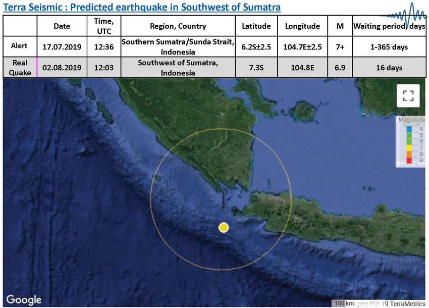
O. Elshin, A. A. Tronin

                               seismic clouds, changes in the behavior of living beings, etc., may be observed be-
                               fore a lot of major earthquakes. Ancient Greeks lived very close to nature and were
                               able to detect unusual phenomena and forecast earthquakes. Multiple sources in-
                               dicate that earthquake forecasting was a recognized science in ancient Greece.
                                  From ancient Greece to the present day, countless scientists have tried to de-
                               velop tools to predict earthquakes. Their attempts usually focused on searching
                               for reliable precursors of forthcoming quakes. Nowadays, seismic and re-
                               mote-sensing methods are considered to have the greatest potential in terms of
                               resolving the earthquake prediction problem. Both of these leading methods can
                               provide the real-time information necessary for global prediction. Scientists have
                               already accumulated enough reliable historic data in order to perform accurate
                               retrospective testing.
                                  The most natural means of predicting earthquakes is by studying seismicity.
                               Thus, seismic methods represent a first-choice group of methodologies for
                               earthquake prediction. Various attempts have been made to predict earthquakes
                               based on local seismicity analysis. One of the most outstanding achievements of
                               the 1980s was the development of the family of M8 algorithms by Vladimir Kei-
                               lis-Borok et al. [1]-[6]. However, a critical analysis of the forecasts it predicts has
                               revealed a low success rate.
                                 The second group of methodologies makes use of satellite remote sensing [5]
                               [7] [8] [9]. A wide range of remote sensing methods has been applied to earth-
                               quake analysis and prediction such as visible and infra-red observations, satellite
                               radar interferometry, and thermal surveying, among others. GPS methods have
                               also been used. Data have been collated from several geophysical parameters to
                               obtain a possible prediction signal: the Earth’s surface, sea surface and air tem-
                               peratures, outgoing longwave radiation (OLR) [10], humidity, surface displace-
                               ment, etc. Numerous anomalies were recorded by many researchers before dif-
                               ferent earthquakes using remote sensing satellite techniques on land and sea
                               surfaces and in the atmosphere.

                               2. Geophysics and Global Earthquake Prediction
                               The Terra Seismic global prediction methodology adheres to some widely ac-
                               cepted assumptions and is based on the observation and detection of real geo-
                               physical processes that always take place below the earth’s surface before earth-
                               quakes [11]-[21]. While earthquakes happen very suddenly for humans, they are
                               not sudden for nature. In nature, earthquakes build up over time in a gradual
                               process involving the accumulation of a huge amount of physical stress. This
                               accumulated stress is subsequently released as an enormous amount of energy
                               when the earthquake strikes. For example, a magnitude 7 earthquake releases the
                               same amount of energy as 32 Hiroshima bombs. Our method is based on the
                               premise that such a huge accumulation of stress can be successfully detected well
                               in advance. The area of future earthquake will be stressed, and, as a result, it will
                               behave differently compared to other areas in the vicinity.

DOI: 10.4236/ojer.2020.92010                         171                         Open Journal of Earthquake Research
O. Elshin, A. A. Tronin

                                  Actually, real earthquake prediction is very similar to the diagnosis of under-
                               lying human illnesses based on observing and analyzing each patient’s signs and
                               symptoms. Just like a fever is an indication to visit a doctor because something is
                               wrong, anomalies in geophysical parameters indicate something is wrong in that
                               specific part of the world. Before an earthquake strikes, we can notice anomalies
                               in the data we collect. These deviations tell us that an event is coming. Major
                               earthquakes are very rare but recurring events; they may take place in a specific
                               area once every 30, 40, 50, 70 or even 100 years. As can be expected, we can ob-
                               serve historically unique combinations of certain parameters in stressed areas
                               before they are hit by a forthcoming earthquake.
                                  Major earthquakes require more time to develop and, therefore, can be de-
                               tected earlier. For example, based on our current systems, we would have de-
                               tected the following famous earthquakes with the lead times (detection time be-
                               fore the earthquake) given in Table 1.
                                  In many cases, the greater the magnitude of the forthcoming event, the larger
                               the area of observed stressed. The size of observed stressed areas roughly cor-
                               responds to estimates derived from the famous Dobrovolsky formula [22]. Also,
                               fully in line with our expectations, we discovered that the size of the stressed area
                               gradually increases during the longer buildup period associated with large mag-
                               nitude events.

                               3. New Approach Based on Worldwide Big Data Acquisition
                                  and Processing
                               To develop our prediction method, our R&D team accumulated all the available
                               data on earthquakes, their precursors and earthquake prediction from all sources
                               over the last 2000 years. While some scientists concentrate most of their efforts
                               and research on just one specific country or region, such as Japan or California,
                               thanks to Big Data, our team can efficiently analyze data from the whole world
                               in almost real time. We’ve discovered that reliable data for some specific regions,

                               Table 1. Lead time periods: earthquake became detectable based on current prediction
                               systems.

                                   No.         Date                     Earthquake                     Lead Time

                                    1        12-11-2017                M7.3 Iran-Iraq                   4 months

                                    2        24-08-2014             M6 Napa, California                 5 months

                                    3        07-09-2017            M8.2 Chiapas, Mexico                 5 months

                                    4        15-10-2013           M7.1 Bohol, Philippines              10 months

                                    5        17-10-1989         M6.9 Loma Prieta, California           10 months

                                    6        06-04-2009             M6.3 L’Aquila, Italy               12 months

                                    7        14-11-2016         M7.8 Kaikoura, New Zealand             15 months

                                    8        05-07-2019          M7.1 Ridgecrest, California             2 years

                                    9        11-03-2011             M9.1 Tohoku, Japan                   3 years

DOI: 10.4236/ojer.2020.92010                          172                          Open Journal of Earthquake Research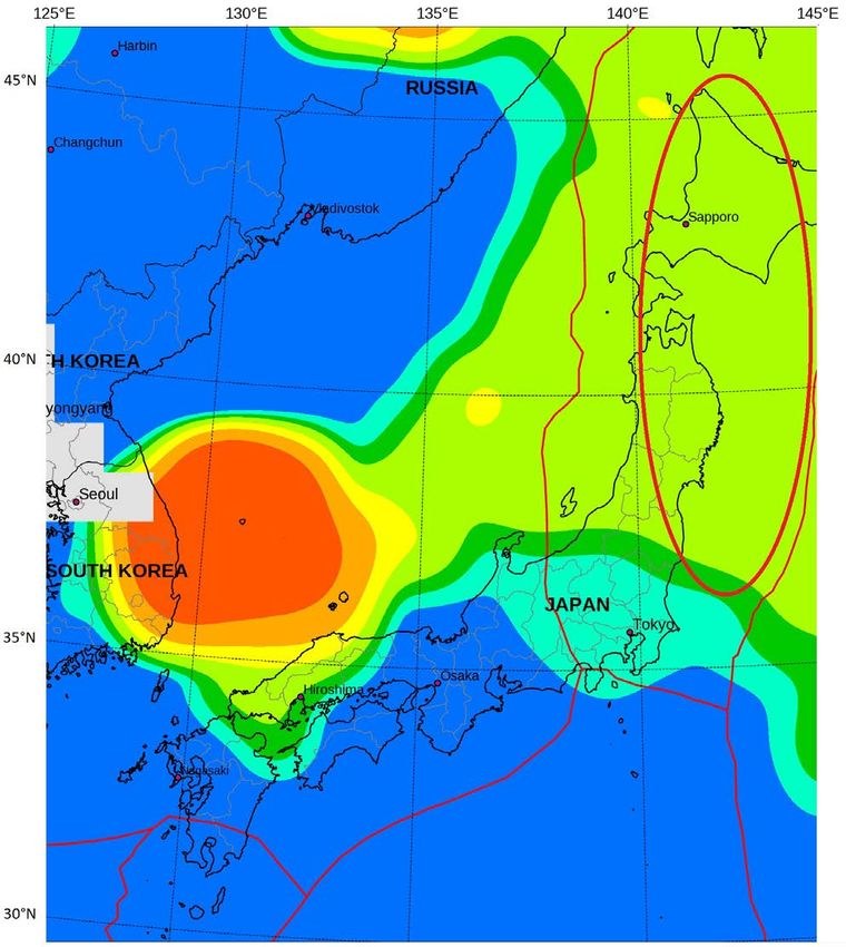
O. Elshin, A. A. Tronin

                               such as California, can be successfully complemented with data from other key
                               seismic regions. So, by applying a global approach based on Big Data applica-
                               tions, we’ve managed to significantly increase the volume of reliable data for de-
                               veloping and testing completely novel theories, models and systems.
                                  We apply innovative satellite Big Data technology capable of processing and
                               analyzing terabytes of information every day. The core of our system is mainly
                               programmed in Python and lives in an open source software ecosystem. The
                               frontend runs on the Apache web server and in the Debian GNU/Linux envi-
                               ronment. The system core generally relies on NumPy for computations and a
                               stack of open source geospatial tools. It uses GDAL to read and process archived
                               satellite data, PROJ to compute the necessary coordinate transformations, and
                               Matplotlib and CartoPy for the final graphics. Some parts of the systems were
                               written in R language which is specifically targeted for statistical computations.
                                  We selected the Python programming language so we could rapidly deploy the
                               system in production and quickly implement new ideas and algorithms, thus
                               constantly expanding the number of parameters involved. The open source Li-
                               nux based software stack also affords us the ability to perform quick and painless
                               deployment and adds greater flexibility when novel features are permanently
                               added to the system.
                                  Original software algorithms analyze satellite images and data from
                               ground-based instruments in order to discover stressed areas based on area-specific
                               comparisons of current data against historical data.

                               4. Terra Seismic Global Earthquake Prediction Technology
                                  Overview
                               Terra Seismic was established in 2012. In 2019, the company relocated to Baar,
                               Switzerland. Terra Seismic can predict most major earthquakes (M6.2 or great-
                               er) at least 2 - 5 months before they will strike. We currently provide earthquake
                               prediction for 25 key earthquake-prone regions: Alaska, the Balkans, California,
                               Canada, the Caribbean, Central America, Chile, China, Greece, India and Pakis-
                               tan, Indonesia, Iran, Italy, the Izu Islands, Japan, Kamchatka and the Kuril Isl-
                               ands, Mexico, Central Asia, New Zealand, Okinawa, Papua New Guinea, Peru,
                               Philippines, Taiwan, and Turkey.
                                  Terra Seismic can identify the epicenter of a forthcoming earthquake with a
                               high level of confidence. At present, the company can identify potentially dan-
                               gerous earthquake areas with a radius of 150 - 250 km. Generally, Terra Seismic
                               does not promise to predict a quake if the earthquake’s epicenter is located
                               beyond a depth of 40 km. Some exceptions are possible. Fortunately, such
                               quakes are almost always harmless, since the quake’s energy is dissipated before
                               reaching the Earth’s surface. Sometimes, instead of a single forecasted earth-
                               quake, a few smaller earthquakes will strike in the specified area and time period.
                               In such cases, Terra Seismic’s systems correctly predict the sum total of the
                               energy released by all the smaller seismic strikes. For this reason, the actual
                               quake magnitude is sometimes less than the predicted one.

DOI: 10.4236/ojer.2020.92010                       173                         Open Journal of Earthquake Research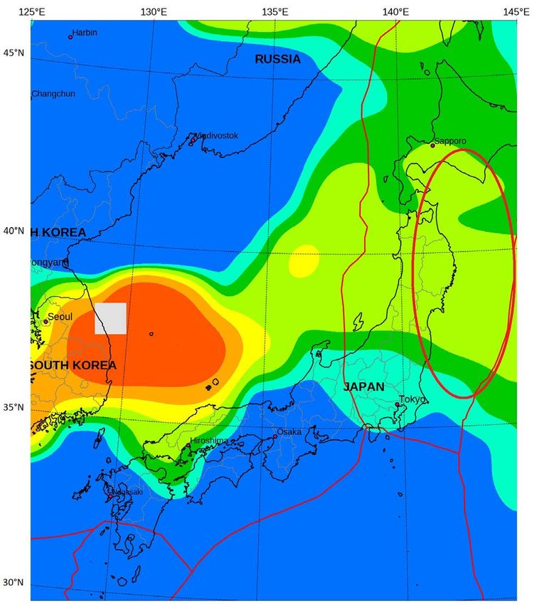
O. Elshin, A. A. Tronin
We develop long-term (from 2 to 5 years), mid-term (from 2 months to 2
years), and short-term (from 10 to 60 days) global prediction systems. The
mid-term systems are the most reliable and can predict most major earthquakes
at least 2 - 5 months in advance.
Terra Seismic technology has been used to retrospectively test data gathered
since 1970, and its systems successfully predicted about 90 percent of all signifi-
cant quakes over the last 50 years. Our technology has been in practical use since
2013. A top California earthquake insurer has been successfully testing our pre-
dictions for nearly five years after they became a Terra Seismic client in 2015.
Terra Seismic is actively working on improving its prediction capabilities.
5. Remote Sensing
All kinds of thermal anomalies have repeatedly been registered before different
earthquakes by many researchers using remote sensing satellite techniques ap-
plied to land and sea surface temperatures [7]. Thermal anomalies associated
with strong earthquakes have been observed at various levels, from the ground
surface up to the top of clouds. At present, the most promising is the Outgoing
Longwave Radiation (OLR) anomaly measured at the top of clouds [10]. The
advantage of this method is that it measures all of the infrared radiation emitted
from the Earth’s surface and atmosphere within the transparency window of 8 -
12 microns. OLR is currently mapped by the AIRS (Atmospheric Infrared
Sounder) instrument launched into orbit in 2002. AIRS is one of six instruments
on board the Aqua satellite, part of NASA’s Earth Observing System.
6. Global Earthquake Prediction. Practical Cases
Let’s demonstrate a few cases of real stress gradually accumulating before major
earthquakes (Figure 1 and Figure 2). At some point the stressed area becomes
detectable for our prediction systems. In many cases, the epicenter of a forth-
coming earthquake is located near the center of the stressed area. However, in
some cases, the epicenter is closer to the boundaries of the stressed area. A poss-
ible explanation is that the rupture zone represents a better indicator for major
earthquakes (rather than the epicenter). The rupture may reach a length of 1300
km for M9 events [23].
7. Results
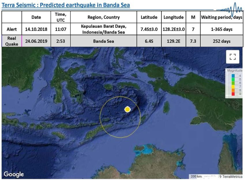
A few recent successful prediction cases are shown in Figures 3-6.
8. Conclusions
Terra Seismic can predict most major earthquakes (M6.2 or greater) at least 2 - 5
months before they will strike. Global earthquake prediction is based on deter-
minations of the stressed areas that will start to behave abnormally before major
earthquakes. The size of the observed stressed areas roughly corresponds to es-
timates calculated from Dobrovolsky’s formula. To identify abnormalities and
DOI: 10.4236/ojer.2020.92010 174 Open Journal of Earthquake Research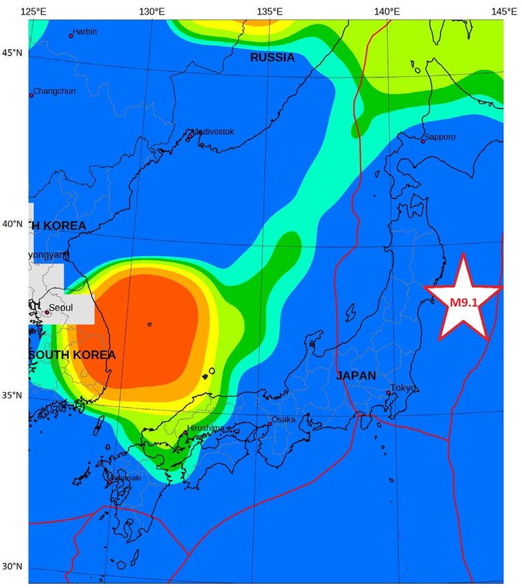
O. Elshin, A. A. Tronin

                                (a)                                                             (b)

                                (c)                                                             (d)

Figure 1. Example of prognostic signal analysis for M9.1 Tohoku earthquake 11 Mar 2011: (a) Mar 2010, (b) Aug 2010, (c) Mar
2011, (d) Apr 2011, after the shock. Note that the green stressed area grew larger in March 2011 due to an increased accumulation
of stress. The red ellipse indicates the prognostic signal.

                                        make predictions, Terra Seismic applies various methodologies, including satellite
                                        remote sensing methods and data from ground-based instruments. We currently

DOI: 10.4236/ojer.2020.92010                                  175                          Open Journal of Earthquake Research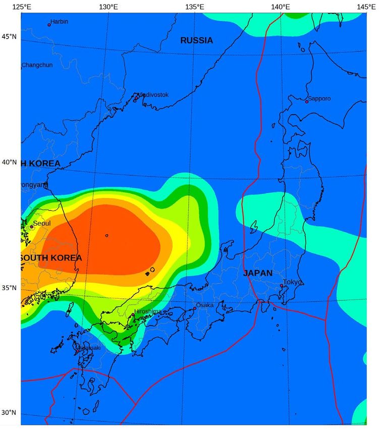
O. Elshin, A. A. Tronin

                                 (a)                                                               (b)

                                 (c)                                                               (d)

Figure 2. An example of how multiple earthquakes developed simultaneously in Indonesia in 2018. Area A: preparation of M6.4
quake on 28.07.2018, M6.9 quake on 05.08.2018, M6.3 quake and M6.9 quake on 19.08.2019 in Lombok Region. Area B: preparation of
M6.2 quake on 28.08.2018 in the East Timor region. (a) Dec 2017, (b) Jan 2018, (c) Jul 2018, (d) Sep 2018, after the shocks. Note
that the cyan stressed areas grew larger due to an increased accumulation of stress. The red ellipse indicates the prognostic signal.

                                         Figure 3. Example of prediction and real quake comparison for 22.10.2018 M6.8 earth-
                                         quake in Vancouver Island, Canada region. Yellow circle indicates prognostic area and
                                         yellow dot shows the location of epicenter.

DOI: 10.4236/ojer.2020.92010                                    176                           Open Journal of Earthquake Research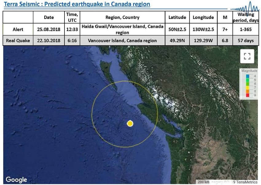
O. Elshin, A. A. Tronin

                               Figure 4. Example of predicted M7.3 earthquake in Banda Sea, Indonesia. Yellow circle
                               indicates prognostic area and yellow dot shows the location of epicenter.

                               Figure 5. Example of predicted M6.9 earthquake in Southwest of Sumatra, Indonesia.
                               Yellow circle indicates prognostic area and yellow dot shows the location of epicenter.

                               process terabytes of information daily, and use more than 80 different multipa-
                               rameter prediction systems. Alerts are issued if the abnormalities are confirmed
                               by at least five different systems. We observed that geophysical patterns of
                               earthquake development and stress accumulation are generally the same for all
                               key seismic regions. Thus, the same earthquake prediction methodologies and
                               systems can be applied successfully worldwide.

DOI: 10.4236/ojer.2020.92010                         177                         Open Journal of Earthquake Research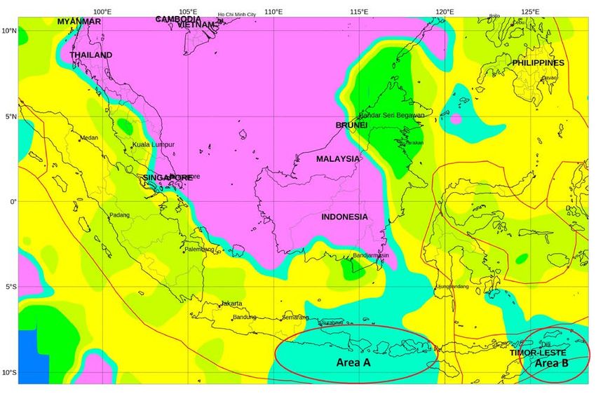
O. Elshin, A. A. Tronin

                               Figure 6. Example of predicted M6.4 earthquake in Puerto Rico region. Yellow circle in-
                               dicates prognostic area and yellow dot shows the location of epicenter.

                                  Stress gradually accumulates before a major earthquake. To measure the dif-
                               ferent stages of stress accumulation, we have developed long-term (from 2 to 5
                               years), mid-term (from 2 months to 2 years), and short-term (from 10 to 60
                               days) global prediction systems. The most reliable are the mid-term systems that
                               can predict most major earthquakes at least 2 - 5 months in advance. In some
                               cases we can determine the final stage of stress build-up. We can also predict the
                               epicenter of a forthcoming earthquake with a high degree of confidence to with-
                               in a radius of 150 - 250 km. Terra Seismic currently provides earthquake predic-
                               tions for 25 key earthquake-prone regions. Our technology has been used to re-
                               trospectively test data gathered since 1970 and it successfully detected about 90
                               percent of all significant quakes over the last 50 years. Throughout 2017-2020,
                               Terra Seismic’s work was presented to more than 150 university professors from
                               63 countries. Our technology has been in practical use since 2013.
                                  Our paramount priority is to help governments save human lives. Terra Seis-
                               mic calls for collaboration with all governments and agencies responsible for
                               dealing with natural disasters.

                               Acknowledgements
                               This project was not possible without the scientific data provided by different
                               government agencies, international organizations, science institutions and aca-
                               demia. We would like to acknowledge their leading contribution to Earth and
                               space data collection.
                                 We wish thank to US Geological Survey (USGS), European-Mediterranean
                               Seismological Centre (EMSC), Japanese Meteorological Agency (JMA), National
                               Aeronautical and Space Administration (NASA), National Oceanic and Atmos-

DOI: 10.4236/ojer.2020.92010                         178                         Open Journal of Earthquake Research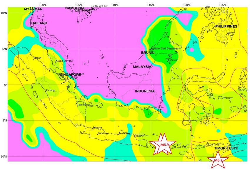
O. Elshin, A. A. Tronin

                               pheric Administration (NOAA), European Space Agency (ESA), International
                               GNSS Service (IGS), Jet Propulsion Laboratory (JPL)/Caltech, Ionospheric Pre-
                               diction Service (IPS), Weather Underground and World Data Center (WDC) in
                               Kyoto, Japan.

                               Conflicts of Interest
                               The authors declare no conflicts of interest regarding the publication of this pa-
                               per.

                               References
                               [1]   Keilis-Borok, V.I. and Kossobokov, V.G. (1990) Premonitory Activation of Earth-
                                     quake Flow: Algorithm M8. Physics of the Earth and Planetary Interiors, 61, 73-83.
                                     https://doi.org/10.1016/0031-9201(90)90096-G
                               [2]   Rathje, E.M. and Adams, B.J. (2008) The Role of Remote Sensing in Earthquake
                                     Science and Engineering: Opportunities and Challenges. Earthquake Spectra, 24,
                                     471-492. https://doi.org/10.1193/1.2923922
                               [3]   Liu, W.L. and Liu, Y.C. (2012) Applicability of Several Seismic Wave Parameters in
                                     Earthquake Prediction. International Research Journal of Geology and Mining, 2,
                                     32-40.
                               [4]   Ogata, Y. (2013) A Prospect of Earthquake Prediction Research. Statistical Science,
                                     28, 521-541. https://doi.org/10.1214/13-STS439
                               [5]   Bobrowsky, P. (2013) Encyclopedia of Natural Hazards. Springer, Dorchester, 1135
                                     p. https://doi.org/10.1007/978-1-4020-4399-4
                               [6]   Ghaedi, K. and Ibrahim, Z. (2017) Earthquake Prediction. In: Zouaghi, T., Ed., Earth-
                                     quakes—Tectonics, Hazard and Risk Mitigation, IntechOpen, London, 205-227.
                                     https://www.intechopen.com/books/earthquakes-tectonics-hazard-and-risk-mitigati
                                     on/earthquake-prediction
                                     https://doi.org/10.5772/65511
                               [7]   Tronin, A.A. (2010) Satellite Remote Sensing in Seismology. A Review. Remote
                                     Sensing, 2, 124-150. https://doi.org/10.3390/rs2010124
                               [8]   Alvan, H.V. and Azad, F.H. (2011) Satellite Remote Sensing in Earthquake Predic-
                                     tion. A Review. National Postgraduate Conference, Kuala Lumpur, 1-5.
                                     https://doi.org/10.1109/NatPC.2011.6136371
                               [9]   Alvan, H.V. and Omar, H. (2011) Overview of Remote Sensing Techniques in
                                     Earthquake Prediction. Journal of Engineering, Design and Technology, 9, 164-177.
                                     https://doi.org/10.1108/17260531111151050
                               [10] Kong, X., Li, N., Lin, L., Xiong, P. and Qi, J. (2018) Relationship of Stress Changes
                                    and Anomalies in OLR Data of the Wenchuan and Lushan Earthquakes. IEEE
                                    Journal of Selected Topics in Applied Earth Observations and Remote Sensing, 11,
                                    2966-2976. https://doi.org/10.1109/JSTARS.2018.2839089
                               [11] Kalvik, J. (2019) Nobel Prize to Oleg Elshin and Terra Seismic Will Help Protect
                                    Humanity from Earthquakes and Tsunamis.
                                    http://www.etterretningen.no/2019/08/16/nobel-prize-to-oleg-elshin-and-terra-seis
                                    mic-will-help-protect-humanity-from-earthquakes-and-tsunamis
                               [12] Carlucci, R. (2018) Terra Seismic con i Big Data satellitari candidata al Nobel per la
                                    Pace nella previsione dei terremoti.
                                    https://rivistageomedia.it/2018050314651/Scienze-della-Terra/terra-seismic-con-i-b

DOI: 10.4236/ojer.2020.92010                          179                           Open Journal of Earthquake Research
O. Elshin, A. A. Tronin
ig-data-satellitari-candidata-al-nobel-per-la-pace-nella-previsione-dei-terremoti-1
[13] Marr, B. (2015) Big Data: Saving 13,000 Lives a Year by Predicting Earthquakes?
http://www.forbes.com/sites/bernardmarr/2015/04/21/big-data-saving-13000-lives-
a-year-by-predicting-earthquakes
[14] Norway News (2018) Terra Seismic Can Save Millions of Lives and Create a New,
Safer Earth for Mankind.
http://www.norwaynews.com/terra-seismic-saving-millions-lives-a-year-by-predicti
ng-earthquakes
[15] Kassandra Petsas, Bodoposten (2018) Terra Seismic nominert til Nobels Fredspris:
Eksklusivt intervju!
http://xn--bodposten-n8a.no/terra-seismic-nominert-til-nobels-fredspris-eksklusivt
-intervju
[16] Alice Scarsi, Express (2018) Earthquakes Can Be Predicted to “Protect Mankind”.
Nobel Prize Nominee Claims.
http://www.express.co.uk/news/world/1049598/earthquakes-today-forecast-news-ea
rthquakes-terra-seismic
[17] Kassandra Petsas, Bodoposten (2018) Terra Seismic kan skape en ny, tryggere ver-
den. http://xn--bodposten-n8a.no/terra-seismic-kan-skape-en-ny-tryggere-verden
[18] CNN Philippines (2019) Live Interview with Oleg Elshin.
https://www.youtube.com/watch?v=x1erNJVtM4U&fbclid=IwAR19kZFjwZgiA3B6
bP_3hmF_uJ3m2_p3YC3uGJIfZ1Uyop7uybDYV__kU9E
[19] BNAmericas (2015) Predicting Earthquakes “No Longer a Rough Science”.
http://www.bnamericas.com/en/news/insurance/predicting-earthquakes-no-longer-
a-rough-science
[20] Marr, B. How Terra Seismic Uses Big Data in Practice.
https://www.bernardmarr.com/default.asp?contentID=729
[21] Marr, B. (2016) Big Data in Practice. How 45 Successful Companies Used Big Data
Analytics to Deliver Extraordinary Results. In: Terra Seismic: Using Big Data to
Predict Earthquakes, Wiley, Hoboken, Chapter 39.
https://doi.org/10.1002/9781119278825
[22] Dobrovolsky, I.P., Zubkov, S.I. and Miachkin, V.I. (1979) Estimation of the Size of
Earthquake Preparation Zones. Springer, Berlin.
https://link.springer.com/article/10.1007/BF00876083
https://doi.org/10.1007/BF00876083
[23] Lay, T., et al. (2005) The Great Sumatra-Andaman Earthquake of 26 December
2004. Science, 308, 1127-1133. https://doi.org/10.1126/science.1112250
DOI: 10.4236/ojer.2020.92010 180 Open Journal of Earthquake ResearchYou can also read