Haleʻiwa Small Boat Harbor Maintenance Dredging and Beach Restoration Haleʻiwa, Island of Oʻahu, Hawaiʻi
←
→
Page content transcription
If your browser does not render page correctly, please read the page content below
Haleʻiwa Small Boat Harbor Maintenance
    Dredging and Beach Restoration
   Haleʻiwa, Island of Oʻahu, Hawaiʻi
                   SECTION 1122
WATER RESOURCES DEVELOPMENT ACT (WRDA) OF 2016
    BENEFICIAL USE OF DREDGED MATERIAL (BUDM)

      DRAFT INTEGRATED FEASIBILITY REPORT
        AND ENVIRONMENTAL ASSESSMENT

               November 2020
                   Prepared by:

       United States Army Corps of Engineers
                  Honolulu District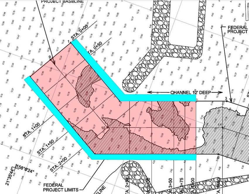
This page left blank intentionally.
Executive Summary

This report presents the evaluation of beneficial uses for dredged material resulting from the routine
maintenance dredging of the federal channel at Haleʻiwa Small Boat Harbor. Beneficial use of dredged
material can provide benefits to the navigation, coastal storm risk management, recreation, and
environmental missions. Despite general perceptions of the pristine sand beaches of Hawaiʻi, sand is
relatively scarce. The study area contains one of the most visited beaches outside of Waikiki, Haleʻiwa
Beach Park, and therefore is a high-value opportunity for receipt of beach grade sand dredged in
accordance with authority granted under Section 1122 of Water Resources Development Act (WRDA) of
2016, as amended.

This study evaluated alternatives for beneficial use based on economic, engineering, environmental and
other factors. The Recommended Plan maximized both economic and ecosystem restoration benefits
making it the National Economic Development (NED) Plan and the National Ecosystem Restoration
(NER) Plan. Beneficial use of dredged material for the purposes of beach restoration is strongly
supported by local stakeholders including the State of Hawaiʻi Department of Land and Natural
Resources (DLNR) Office of Conservation and Coastal Lands (OCCL) and Division of Boating and
Ocean Recreation (DOBOR), as well as the City and County of Honolulu Department of Parks and
Recreation. The non-federal sponsor for this project is the State of Hawaii as represented by DLNR
OCCL and DOBOR.

The Recommended Plan, Alternative 4, consists of beneficial use from the Federal Navigation Channel
maintenance dredging to 13 ft mean lower low water (MLLW), a shoaling deposit caused by a state
owned breakwater, hereafter referred to as State Breakwater Settling Basin, and the Offshore Sand
Borrow Area. This plan involves the beneficial use of dredged material from these locations for the
purposes of restoring aquatic habitat and reducing storm damage to property and infrastructure. The
dredged material from these locations that is beach suitable will be used to nourish the beach which is
part of the Haleʻiwa Beach Shore Protection Project (HBSPP), adjacent to Haleʻiwa Beach Park (HBP).
Dredging from these locations will yield approximately 26,071cubic yards (cy) of beach suitable sand
and will be used to restore 4.4ac of beach. The fine-grained dredged material from the Federal
Navigation Channel that is not suitable for beach restoration, approximately 2,000 cy, will be
transported by scow and taken to the South Oʻahu Ocean Dredged Material Disposal Site (ODMDS).

The beach is part of the federally authorized HBSPP, and nourishment with dredged material will help
restore the beach to its original extent. This will produce both NER and NED benefits in the form of
restored habitat for the green sea turtle, recreational benefits, and storm damage reduction benefits. The
Recommended Plan is both the NER and NED plan and provides a net increase of 1.87 average annual
habitat units and an economic benefit of $18,525,000 with a Benefit-Cost Ratio BCR of 3.85.

The Recommended Plan has an estimated total project first cost (Constant Dollar Cost at FY20 price
levels) of $3,068,000. This cost represents the incremental total project cost over the Base Plan, which
would be maintenance dredging of the federal channel and disposing of dredged material at the South
Oʻahu ODMDS. The fully funded total project cost for the Recommended Plan is $3,261,000 including
escalation to the midpoint of construction. The non-federal share of the project components is
estimated at $1,798,800 and will be funded by the local sponsor. The federal share of the project
components is estimated at $1,269,200.

 Section 1122 Beneficial Use of Dredged Material                                                   Page i
 Feasibility Study, Haleʻiwa, Oʻahu, Hawaii
List of Abbreviations and Acronyms

AAHU   Average Annual Habitat Unit                Report/Environmental Assessment
AAC    Average Annual Cost                        IWR         Institute for Water Resources
BCR    Benefit Cost Ratio                         MBTA        Migratory Bird Treaty Act
BU     Beneficial Use                             MLLW        Mean Lower Low Water
BUDM   Beneficial Use of Dredged Material         MSA         Magnuson-Stevens Fishery
CAA    Clean Air Act                                          Conservation Management
CAP    Continuing Authorities Program             MUS         management unit species
CE/ICA Cost Effective/Incremental Cost            NED         National Economic Development
       Analysis                                   NEPA        National Environmental Policy Act
CEQ    Council for Environmental Quality          NER         National Ecosystem Restoration
CWA    Clean Water Act                            NFS         Non-Federal Sponsor
CY     Cubic yards                                NHPA        National Historic Preservation Act
CZMA Coastal Zone Management Act                  NMFS        National Marie Fisheries Service
DLNR Department of Lands and Natural              NOAA        National Oceanic Atmospheric
       Resources                                              Administration
DMMP Dredged Material Management Plan             NPDES       National Pollutant Discharge
DOBOR Division of Boating and Ocean                           Elimination System
       Recreation                                 NRHP        National Register of Historic
DPS    Distinct Population Negments                           Places
EA     Environmental Assessment                   OCCL        Office of Conservation and Coastal
EC     Engineering Circular                                   Lands
EFH    Essential Fish Habitat                     ODMDS       Ocean Dredged Material Disposal
EO     Executive Order                                        Site
ER     Engineering Regulation                     O&M         Operations and Maintenance
ESA    Endangered Species Act                     OMRR&R Operations, Maintenance, Repair,
EPA    Environmental Protection Agency                        Rehabilitation and Replacement
FEP    Fishery Ecosystem Plans                    PPA         Project Partnership Agreement
FONSI Finding of No Significant Impact            S&A         Supervision and Administration
FWCA Fish and Wildlife Coordination Act           SLC         Sea level change
GNF    General Navigation Feature                 SLR         Sea level rise
HBP    Haleʻiwa Beach Park                        TSP         Tentatively Selected Plan
HSBH Haleʻiwa Small Boat Harbor                   U.S.        United States
HBSPP Haleʻiwa Beach Shore Protection             USACE       U.S. Army Corps of Engineers
       Project                                    USFWS       U.S. Fish and Wildlife Service
HU     Habitat Unit                               USC         United States Code
HTRW Hazardous Toxic Radioactive Waste            WRDA        Water Resources Development Act
IFR/EA Integrated Feasibility
                                                  UNITS
                                                    Acres ac
                                                    Cubic Yards     cy
                                                    Feet ft

Section 1122 Beneficial Use of Dredged Material                                          Page ii
Feasibility Study, Haleʻiwa, Oʻahu, Hawaii
Pertinent Data

                                            Recommended Plan
                                              Sand Placement
                                      Placement Amount (cy)       26,071
                                    Length of Placement Area (ft) 1,000
                                    Width of Placement Area (ft)   200

                                              Economic Information
   Item                                                                                                 Amount ($)
   Total Design and Construction Costs                                                                   3,068,000

   Total Annual National Economic Development Cost (50 years)                                                  93,000
   Annual Benefits                                                                                            531,000
   Average Net Annual Benefits                                                                                483,000
   Benefit to Cost Ratio                                                                                         3.85
    Note: Totals may not sum due to rounding.

                         Conversion Table for SI (Metric) Units
   Multiply                    By                        To Obtain
   Cubic Yards (cy)        0.7646       Cubic Meters
   Acre (ac)               0.4049       Hectare
   Feet (ft)               0.3048       Meters
   Feet Per Second         0.3048       Meters Per Second
   Inches                  2.5400       Centimeters
   Knots (international)   0.5144       Meters Per Second
   Miles (U.S. Statute)    1.6093       Kilometers
   Miles (Nautical)        1.8520       Kilometers
   Miles Per Hour          1.6093       Kilometers Per Hour
   Pounds (mass) (lb)      0.4536       Kilograms
   *To obtain Celsius (C) temperature readings from Fahrenheit (F) readings, use the followin g formula: C = (5/9)(F-32)

Section 1122 Beneficial Use of Dredged Material                                                                      Page ii
Feasibility Study, Haleʻiwa, Oʻahu, Hawaii
TABLE OF CONTENTS

1.0     Introduction .................................................................................................................. 2
  1.1      Authority ................................................................................................................... 2
  1.2      Study Purpose and Scope ........................................................................................... 2
  1.3      Location and Study Area ............................................................................................ 4
  1.4      Description of Federal Projects................................................................................... 5
      1.4.1       Haleʻiwa Small Boat Harbor................................................................................ 5
      1.4.2       Haleʻiwa Beach Shore Protection Project ............................................................. 6
  1.5      Historical Dredging of Haleʻiwa Small Boat Harbor.................................................... 8
  1.6      Study Participants and Coordination ........................................................................... 8
  1.7      Related Studies and Reports ....................................................................................... 8
2.0     Affected Environment-Existing Conditions .................................................................. 10
  2.1      Physical Setting ....................................................................................................... 10
      2.1.1       Climate............................................................................................................. 10
      2.1.2       Geology and Geomorphology............................................................................ 10
      2.1.3       Land Use .......................................................................................................... 11
      2.1.4       Soils ................................................................................................................. 11
      2.1.5       Benthic Substrate .............................................................................................. 11
      2.1.6       Bathymetry and Nearshore Bottom Conditions .................................................. 12
      2.1.7       Tides, Water Levels, and Sea Level Change....................................................... 13
      2.1.8       Littoral Sand Transport ..................................................................................... 17
      2.1.9       Winds............................................................................................................... 17
      2.1.10 Waves .............................................................................................................. 18
  2.2      Social and Economic Resources ............................................................................... 20
      2.2.1       Haleʻiwa Small Boat Harbor.............................................................................. 20
      2.2.2       Haleʻiwa Beach Park ......................................................................................... 20
      2.2.3       Demographics................................................................................................... 24
      2.2.4       Socioeconomic and Environmental Justice......................................................... 24
  2.3      Biological Resources ............................................................................................... 24
      2.3.1       Wetlands .......................................................................................................... 24
      2.3.2       Terrestrial Habitats ........................................................................................... 25
      2.3.3       Aquatic Species and Habitats ............................................................................ 25

Section 1122 Beneficial Use of Dredged Material                                                                                  Page iii
Feasibility Study, Haleʻiwa, Oʻahu, Hawaii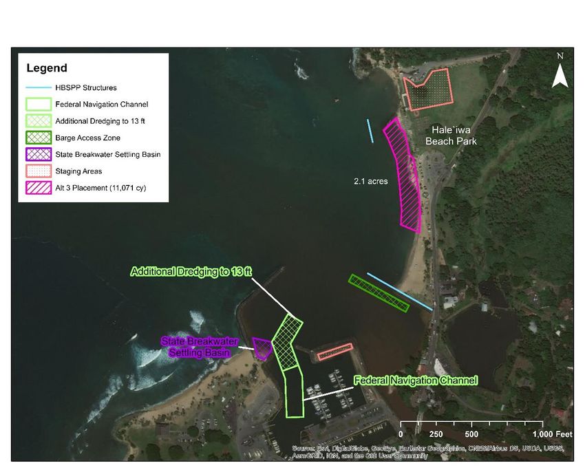
2.3.4      Endangered and Threatened Species .................................................................. 27
      2.3.5      Fish and Essential Fish Habitat.......................................................................... 28
      2.3.6      Essential Fish Habitat Designation .................................................................... 29
      2.3.7      Vegetation ........................................................................................................ 31
      2.3.8      Birds ................................................................................................................ 31
  2.4      Air Quality .............................................................................................................. 31
  2.5      Water Quality .......................................................................................................... 31
  2.6      Aesthetic Quality ..................................................................................................... 31
  2.7      Noise....................................................................................................................... 32
  2.8      Hazardous and Toxic Substances.............................................................................. 32
  2.9      Historical and Archeological Resources.................................................................... 32
3.0     Plan Formulation......................................................................................................... 34
  3.1      Purpose and Need .................................................................................................... 34
  3.2      Problems ................................................................................................................. 34
  3.3      Opportunities and Constraints .................................................................................. 35
      3.3.1      Opportunities.................................................................................................... 35
      3.3.2      Constraints (Factors to avoid)............................................................................ 36
  3.4      Objectives ............................................................................................................... 36
      3.4.1      Federal Planning Objectives .............................................................................. 36
      3.4.2      Specific Planning Objectives ............................................................................. 37
  3.5      Future Without Project Condition ............................................................................. 37
      3.5.1      Navigation........................................................................................................ 37
      3.5.2      Haleʻiwa Beach Park ......................................................................................... 37
      3.5.3      Biological Environment .................................................................................... 37
  3.6      Formulation of Measures ......................................................................................... 38
      3.6.1      Dredging, Transport, and Placement Methods .................................................... 38
      3.6.2      Beneficial Uses of Dredged Material ................................................................. 38
      3.6.3      Other Dredged Material Placement Options....................................................... 39
      3.6.4      Dredging Locations .......................................................................................... 39
      3.6.5      Preliminary Screening of Measures ................................................................... 41
      3.6.6      Array of Alternatives Considered ...................................................................... 43
4.0     Comparison of Alternatives ......................................................................................... 44
  4.1      Alternative Plan Descriptions ................................................................................... 44

Section 1122 Beneficial Use of Dredged Material                                                                                Page iv
Feasibility Study, Haleʻiwa, Oʻahu, Hawaii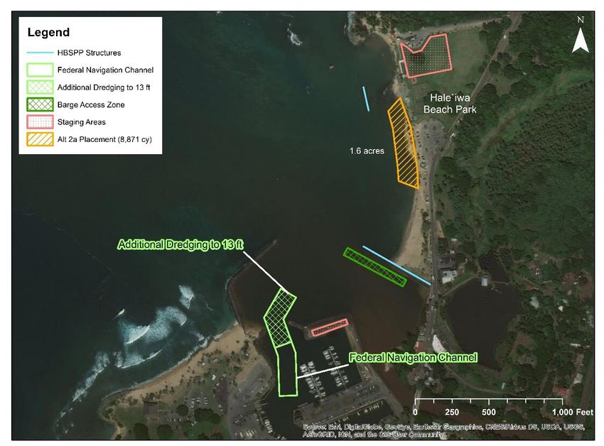
4.1.1 Alternative 1- No Action Alternative ................................................................. 44
4.1.2 Alternative 2 – Beneficial Use of Dredged Material from Federal Channel to 12 ft
MLLW Depth ................................................................................................................ 45
4.1.3 Alternative 2A - Beneficial Use of Dredged Material from Federal Channel to 13 ft
MLLW Depth ................................................................................................................ 46
4.1.4 Alternative 3– Beneficial Use of Dredged Material from Federal Channel to 13 ft
MLLW and Settling Basin.............................................................................................. 48
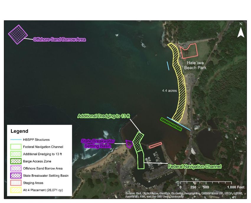
4.1.5 Alternative 4: Beneficial Use of Dredged Material from Federal Channel to 13 ft
MLLW, Settling Basin, and Offshore Sand Borrow Area................................................. 50
4.2 Preliminary Screening of Alternative Plans ............................................................... 52
4.3 Base Plan Costs ....................................................................................................... 53
4.4 Costs of Alternatives................................................................................................ 53
4.4.1 Operations and Maintenance Costs .................................................................... 53
4.4.2 Alternative Costs .............................................................................................. 53
4.5 Ecological Outputs................................................................................................... 55
4.6 Economic Benefits................................................................................................... 56
4.7 Cost Effectiveness Incremental Cost Analysis........................................................... 57
4.8 Evaluation of Alternatives ........................................................................................ 59
4.9 Plan Selection .......................................................................................................... 61
5.0 Recommended Plan ..................................................................................................... 62
5.1 Plan Description ...................................................................................................... 62
5.1.1 Plan Components.............................................................................................. 62
5.2 Detailed Cost Estimate of the Recommended Plan .................................................... 65
5.3 Summary of Significance ......................................................................................... 65
5.3.1 Institutional Significance................................................................................... 65
5.3.1 Public Significance ........................................................................................... 66
5.3.1 Technical Significance ...................................................................................... 67
5.4 Residual Risk .......................................................................................................... 68
5.5 Integration of Environmental Operating Principles .................................................... 68
5.6 Summary of Accounts.............................................................................................. 69
5.6.1 National Economic Development ...................................................................... 69
5.6.2 Regional Economic Development...................................................................... 69
5.6.3 Environmental Quality ...................................................................................... 69
5.6.4 Other Social Effects.......................................................................................... 70
Section 1122 Beneficial Use of Dredged Material Page v
Feasibility Study, Haleʻiwa, Oʻahu, Hawaii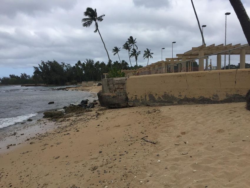
6.0     Environmental Impacts ................................................................................................ 71
  6.1      Physical Environment .............................................................................................. 71
      6.1.1      Water Quality ................................................................................................... 71
      6.1.2      Air Quality ....................................................................................................... 71
      6.1.3      Aesthetic Quality .............................................................................................. 71
      6.1.4      Noise................................................................................................................ 72
      6.1.5      Human Activity ................................................................................................ 72
  6.2      Biological Resources ............................................................................................... 72
      6.2.1      Terrestrial Habitat............................................................................................. 72
      6.2.2      Federal and State Threatened and Endangered Species ....................................... 72
      6.2.3      Fishery Resources and Essential Fish Habitat..................................................... 73
  6.3      Coastal Zone Resource Management ........................................................................ 73
  6.4      Historical and Archaeological Resources .................................................................. 73
  6.5      Environmental Justice and Protection of Children ..................................................... 73
  6.6      Cumulative and Long-term Impacts.......................................................................... 73
  6.7      Summary of Mitigation Measures............................................................................. 74
      6.7.1      No Action Plan ................................................................................................. 74
      6.7.2      Recommended Plan .......................................................................................... 74
  6.8      Plan Selection .......................................................................................................... 74
7.0     Public and Agency Involvement .................................................................................. 75
  7.1      Public/Scoping Meetings.......................................................................................... 75
  7.2      Federal and State Agency Coordination .................................................................... 75
      7.2.1      Pre-Consultation Agency Coordination.............................................................. 75
  7.3      Status of Environmental Compliance (Compliance Table) ......................................... 75
      7.3.1      Relationship to Environmental Laws and Compliance ........................................ 75
  7.4      Views of the Non-Federal Sponsor ........................................................................... 80
8.0     Plan Implementation Requirements.............................................................................. 81
  8.1      Non-Federal Responsibilities.................................................................................... 81
  8.2      Federal Responsibilities ........................................................................................... 81
  8.3      In-Kind Contributions.............................................................................................. 81
  8.4      Cost Sharing ............................................................................................................ 81
  8.5      Project Partnership Agreement ................................................................................. 83
  8.6      Operations and Maintenance .................................................................................... 83

Section 1122 Beneficial Use of Dredged Material                                                                               Page vi
Feasibility Study, Haleʻiwa, Oʻahu, Hawaii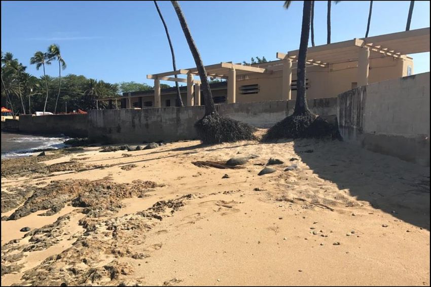
8.7     Monitoring and Adaptive Management..................................................................... 84
   8.8     Mitigation................................................................................................................ 84
   8.9     Implementation Schedule ......................................................................................... 84
   8.10       Real Estate Considerations ................................................................................... 84
   8.11       Risk and Uncertainty ............................................................................................ 85
   8.12       Local Betterments ................................................................................................ 85
   8.13       Monitoring........................................................................................................... 85
9.0      Conclusions and Recommendations ............................................................................. 86
   9.1     Conclusions............................................................................................................. 86
   9.2     Recommendations ................................................................................................... 86
10.0 References and Prior Studies ....................................................................................... 87

Section 1122 Beneficial Use of Dredged Material                                                                             Page vii
Feasibility Study, Haleʻiwa, Oʻahu, Hawaii
List of Tables
Table 1. USACE dredging history of Haleʻiwa Harbor .............................................................. 8
Table 2. Water level data for Haleʻiwa Harbor ........................................................................ 13
Table 3. Shoaling volume and rate ......................................................................................... 20
Table 4. Resource categories and mitigation goals (USFWS, August 2020). ............................ 26
Table 5 Bottomfish MUS species ........................................................................................... 28
Table 6 Crustaceans MUS species .......................................................................................... 29
Table 7 Pelagic MUS species ................................................................................................. 29
Table 8 EFH designation for Bottomfish MUS ....................................................................... 30
Table 9 EFH designation for Crustaceans MUS ...................................................................... 30
Table 10 EFH designation for Pelagics MUS.......................................................................... 30
Table 11. Preliminary measures considered ............................................................................ 42
Table 12. Final array of alternatives ....................................................................................... 43
Table 13. Alternative 2 dredged material volume and uses ...................................................... 45
Table 14. Alternative 2A dredged material volume and uses ................................................... 47
Table 15. Alternative 3 dredged material volume and uses ...................................................... 49
Table 16. Alternative 4 dredged material volume and uses ...................................................... 51
Table 17. Base Plan Costs for All Alternatives........................................................................ 53
Table 18. Alternative costs..................................................................................................... 54
Table 19. Habitat outputs ....................................................................................................... 55
Table 20. Economic Benefits ................................................................................................. 57
Table 21. Cost Effectiveness and Incremental Cost Analysis ................................................... 58
Table 22. Alternative comparison criteria ............................................................................... 60
Table 23. Total project cost of the Recommended Plan ........................................................... 65
Table 24: Summary of relevant federal statutory authorities .................................................... 80
Table 25. Cost share allocation............................................................................................... 83
Table 26: Design and implementation schedule ...................................................................... 84

List of Figures
Figure 1. Project location ......................................................................................................... 4
Figure 2. Project location and study area .................................................................................. 5
Figure 3. Haleʻiwa Small Boat Harbor federal project ............................................................... 6
Figure 4. Photo of Haleʻiwa Beach Park, circa 1970, depicting the historic extent of beach and
tombolo (Sea Engineering Inc., 2019) ...................................................................................... 7
Figure 5. Bathymetry and topography, Haleʻiwa Beach park. (Sea Engineering, Inc., 2019) ..... 12
Figure 6. Extreme water levels at Honolulu Harbor, Oʻahu ...................................................... 14
Figure 7. Sea level trend for Honolulu, Hawaiʻi (NOAA, 2020)............................................... 15
Figure 8. Interannual variation at Honolulu Harbor NOAA tide station.................................... 16
Figure 9. Relative sea level change curves at Honolulu Harbor NOAA tide station .................. 17
Figure 10. Wind rose from WIS station 82508 ........................................................................ 18
Figure 11. Wave height rose from CDIP buoy 106 .................................................................. 19
Figure 12. Wave period from CDIP buoy 106 ......................................................................... 19
Figure 13. Erosion near WWII monument circa 2019 (SeaEngineering, 2019) ......................... 22
Figure 14. Beach in front of seawall and comfort station. Note exposed reef rock and root balls.
Photo from 2017 (SeaEngineering, 2019) ............................................................................... 22

Section 1122 Beneficial Use of Dredged Material                                                                           Page viii
Feasibility Study, Haleʻiwa, Oʻahu, Hawaii
Figure 15. National Wetlands Inventory for Hale’iwa Beach Park and vicinity. ....................... 25
Figure 16: Haleʻiwa Beach Park erosion. ................................................................................ 35
Figure 17. Dredging locations ................................................................................................ 41
Figure 18. Alternative 1: No action alternative (Federal Navigation Chan nel shown in green) . 44
Figure 19. Alternative 2: Beneficial use of dredged material at Haleʻiwa Beach Park................ 46
Figure 20. Alternative 2A: additional dredging area to 13 ft .................................................... 47
Figure 21. Alternative 2A: Beneficial use of dredged material at Haleʻiwa Beach Park. ............ 48
Figure 22. Alternative 3: beneficial use beach restoration area................................................. 50
Figure 23. Alternative 4: beneficial use beach restoration area................................................. 52
Figure 24. Cost versus outputs graphs .................................................................................... 59
Figure 25. Recommended Plan components............................................................................ 64

Appendices:
A: Coastal Appendix
B: Environmental Appendix
C: Economic Appendix
D: Cost Engineering Appendix

Section 1122 Beneficial Use of Dredged Material                                                                        Page ix
Feasibility Study, Haleʻiwa, Oʻahu, Hawaii
1.0     INTRODUCTION
This chapter provides information on the study authority, area of concern, study participants,
previous studies that contributed to this product and tasks remaining to be completed prior to the
report being finalized.

     1.1       Authority
This feasibility study is being conducted under authority granted by Section 1122 of the Water
Resources Development Act (WRDA) of 2016 (Public Law (PL) 114-322), as amended. Section
1122 of WRDA 2016 requires U.S. Army Corps of Engineers (USACE) establish a pilot
program to carry out 10 projects for the beneficial use of dredged material, including projects for
the purposes of— (1) Reducing storm damage to property and infrastructure; (2) promoting
public safety; (3) protecting, restoring, and creating aquatic ecosystem habitats; (4) stabilizing
stream systems and enhancing shorelines; (5) promoting recreation; (6) supporting risk
management adaptation strategies; and (7) reducing the costs of dredging and dredged material
placement or disposal.

In general, Section 1122 provides that projects under the pilot program will be cost shared in
accordance with the cost sharing requirements for projects carried out under the Section 204
Continuing Authorities Program (CAP). However, for projects under the pilot program that
utilize dredged material from federal navigation projects, Section 1122(e)(2) provides that the
incremental costs above the Federal Standard for transporting and depositing such dredged
material will be borne entirely by the Federal Government. If such pilot projects involve
additional activities other than transportation and placement of dredged material, such as wetland
plantings or mechanical shaping of dunes and beach berms, those costs shall be shared in
accordance with the cost sharing requirements of Section 204. If additional material is dredged
from a federal navigation project solely for purposes of a pilot project, the costs associated with
the additional dredging will be cost-shared with the non-federal sponsors (NFS) of the pilot
project in accordance with Section 204. If a pilot project relies on dredged material from a non-
federal navigation project, the dredging and transportation costs will be 100% non-federal; all
other costs associated with the pilot project will be cost-shared in accordance with Section 204.

     1.2       Study Purpose and Scope
This study examines the feasibility and environmental effects of implementing beneficial use of
dredged material (BUDM) measures at Haleʻiwa, Oʻahu, Hawaiʻi. Haleʻiwa is located on the
central north coast of the island of Oʻahu, approximately 25 miles northwest of Honolulu. The
project area is shown below in Figure 1. The study area is in Hawaiʻi’s Second Congressional
District, which has the following Congressional delegation: Senator Mazie Hirono (D); Senator
Brian Schatz (D); and, Representative Tulsi Gabbard (D-Honolulu).

Engineering Pamphlet (EP) 1105-2-58 “Continuing Authority Program” describes the policy
requirements associated with projects conducted under this authority. This feasibility document
describes the planning process to demonstrate consistency with applicable policy requirements.

Section 1122 Beneficial Use of Dredged Material                                             Page 2
Feasibility Study, Haleʻiwa, Oʻahu, Hawaiʻi
Engineer Regulation (ER) 200-2-2, “Procedures for Implementing NEPA” and ER 1105-2-100, directs the contents of environmental assessments (EAs). This document and its appendices present the information required by both regulations as an integrated feasibility report and EA. Compliance with the requirements of the Council on Environmental Quality regulations for implementing the National Environmental Policy Act of 1969 (42 United States Code (USC) 4321 et seq.) will be met upon completion of the final decision document. Additionally, this document augments the National Environmental Policy Act (NEPA) requirement to ensure compliance with the Hawaiʻi Revised Statutes Chapter 343, Environmental Impact Statements. This Integrated Feasibility Report and EA (IFR/EA) documents the study and coordination conducted to determine whether the Federal Government should participate in BUDM measures by dredging suitable materials from Haleʻiwa Small Boat Harbor (HSBH) and other suitable areas in the vicinity for placement at the Haleʻiwa Beach Shore Protection Project (HBSPP) that is adjacent to Haleʻiwa Beach Park (HBP), Oʻahu, Hawaiʻi. Studies of potential BUDM measures considered a wide range of alternatives and the environmental consequences of those alternatives but focused mainly on actions that would provide efficient and effective benefits to navigation, coastal storm risk management, recreation, and ecosystem restoration to the study area. The implementation of BUDM measures is growing in interest not just for USACE, but also for other groups interested in the benefits that these measures can provide. The measures proposed by this report generate notable National Economic Development (NED) and National Ecosystem Restoration (NER) benefits. The non-federal sponsor for this project is the State of Hawaii as represented by DLNR. Both DOBOR and OCCL are branches of DLNR, and have stated their intention to serve as cost-share sponsors for the BUDM project at Haleʻiwa Beach. The City and County of Honolulu owns and maintains HBP. This partnership of federal and non-federal interests in BUDM helps ensure that the selected plan will effectively serve both local and national needs. Section 1122 Beneficial Use of Dredged Material Page 3 Feasibility Study, Haleʻiwa, Oʻahu, Hawaiʻi
Oʻahu ↑N
Hawaiʻi
Figure 1. Project location
1.3 Location and Study Area
The project is located on the northeastern shore of the island of Oʻahu, approximately 30 miles
north of Honolulu, Hawaiʻi (Figure 1). The study area (Figure 2) encompasses the federally
authorized HSBH and HBSPP, and the HBP. It is located near the mouth of the Anahulu River
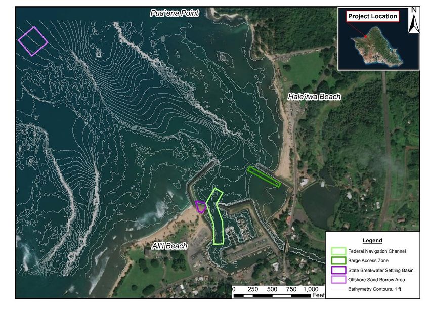
(21° 35’ 49.24” N, 158° 05’ 47.50 W”). The study area also includes a 0.3 acres (ac) shoaling
deposit caused by state owned breakwater (State Breakwater Settling Basin) located immediately
to the east of the state breakwater on Aliʻi Beach, and a 1.7 ac offshore sand deposit (Offshore
Sand Borrow Area) located 3,400 feet (ft) northwest of HBP.
Section 1122 Beneficial Use of Dredged Material Page 4
Feasibility Study, Haleʻiwa, Oʻahu, HawaiʻiOʻahu
Figure 2. Project location and study area
1.4 Description of Federal Projects
The federal projects include the HSBH and the HBSPP.
1.4.1 Haleʻiwa Small Boat Harbor
Haleʻiwa Small Boat Harbor is located at the mouth of the Anahulu River. The State of Hawaiʻi
constructed the outer breakwater for the Harbor in 1955. The harbor was authorized on 26 March
1964 and 25 October 1974 under Section 107 of the River and Harbor Act of 1960, as amended.
The project was the first joint federal-state harbor constructed on Oʻahu. The original federal
project, which was completed in November 1966, consisted of the entrance channel and revetted
mole. The stub breakwater and wave absorber were added in 1975. The current federal general
navigation features of HSBH consist of an entrance channel 740 ft long, 100 – 120 ft wide, with
an authorized depth of -12 ft MLLW; a revetted mole that is 1,310 ft long; a stub breakwater that
is 80 ft long; and a wave absorber that is 140 ft long (Figure 3). Non-federal project features
include 64 berths, 26 moorings, 2 loading docks, and 3 ramps. The NFS for the harbor is the
State of Hawaiʻi, DLNR, DOBOR.
Section 1122 Beneficial Use of Dredged Material Page 5
Feasibility Study, Haleʻiwa, Oʻahu, HawaiʻiFigure 3. Haleʻiwa Small Boat Harbor federal project
1.4.2 Haleʻiwa Beach Shore Protection Project
The federally authorized HBSPP is adjacent to HBP, and is less than one mile from HSBH
(Figure 2). The HBSPP was authorized by the River and Harbor Act of 1965 (Public Law 89-
298) and was constructed in 1965 for the purpose of restoring the eroded public beach at HBP.
The shoreline protection project consists of a sand beach (1,600 ft long and 140-265 ft wide), an
offshore breakwater (160 ft long), and a terminal groin (500 ft long) at the southern end Haleʻiwa
Beach.
In December 1969, the USACE conducted emergency repairs on the groin and offshore
breakwater in response to damages caused by severe storms and placed approximately 12,000 cy
Section 1122 Beneficial Use of Dredged Material Page 6
Feasibility Study, Haleʻiwa, Oʻahu, Hawaiʻiof sand on the beach. Figure 4 shows the shoreline of HBP in the year following the sand
placement, in which a tombolo has formed between the beach and the offshore breakwater. A
tombolo is a deposit of sand that forms between an island or detached breakwater and a
shoreline, due to wave refraction and diffraction. Storms in January 1974 and November 1976
caused damages requiring emergency repairs for the project, in 1975 and 1978, respectively. The
project authorization states that the NFS is responsible for ongoing maintenance of the project
and that the USACE may conduct emergency repairs to the project in accordance with PL 84-99.
The NFS for the HBSPP is the State of Hawaiʻi, Department of Transportation.
Figure 4. Photo of Haleʻiwa Beach Park, circa 1970, depicting the historic extent of beach and
tombolo (Sea Engineering Inc., 2019)
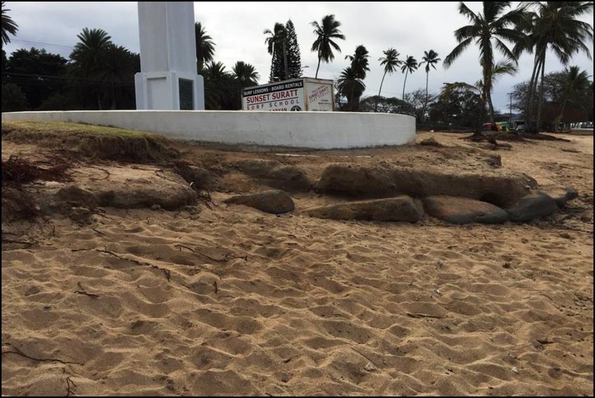
Regular maintenance of the HBSPP has been limited; Haleʻiwa Beach is known to be erosive
with current rates of erosion at an average of 2.2 ft per year (University of Hawaiʻi, 2010).
Recent erosion has exposed underlying beach rock, impacting recreation uses of the beach in the
suitability of sandy habitat for sea turtle nesting. Additionally, the erosion has undermined the
retaining wall associated with the comfort station. The City and County of Honolulu completed
repairs of the damaged seawall in 2020.
Section 1122 Beneficial Use of Dredged Material Page 7
Feasibility Study, Haleʻiwa, Oʻahu, Hawaiʻi1.5 Historical Dredging of Haleʻiwa Small Boat Harbor
HSBH has been dredged twice since initial construction: (1) 7,214 cubic yards (cy) in 1999 and
(2) approximately 6,500 cy in 2009 (Table 1). Both times, the material was disposed upland.
In 2018, the USACE developed the HSBH Dredge Material Management Plan, identifying South
Oʻahu Ocean Dredged Material Disposal Site as the Federal Standard. The Federal Standard is
defined in USACE regulations as the least costly dredged material disposal or placement
alternative identified by USACE that is consistent with sound engineering practices and meets all
federal environmental requirements. It is also USACE policy to fully consider all aspects of the
dredging and placement operations while maximizing benefits to the public. Beneficial use
options for the dredged material should be given full and equal consideration with other
alternatives.
Table 1. USACE dredging history of Haleʻiwa Harbor
Year Type of Work Type of Disposal Volume (cy) Total Cost Unit Cost
1999 maintenance upland 7,200 $208,000 $29.00
2009 maintenance upland 4,556 $1,300,000 $252.00
1.6 Study Participants and Coordination
The Honolulu District, USACE was primarily responsible for conducting studies for BUDM
measures at Haleʻiwa. The studies that provide the basis for this report were conducted with the
assistance of many individuals and agencies, including the City and County of Honolulu, United
States Fish and Wildlife Service (USFWS), the State of Hawaiʻi Historic Preservation Officer,
the State of Hawaiʻi Department of Fish and Game, the State of Hawaiʻi Department of Health,
the State of Hawaiʻi DLNR, and many members of the interested public who contributed
information and constructive criticism to improve the quality of this report.
1.7 Related Studies and Reports
The following reports provided pertinent information that was critical to the decision making and
feasibility study process. Additional referenced reports are provided in Chapter 10 of this
document.
1) Concept Designs for Selected Beach Parks. Volume 1 Haleʻiwa Beach Park. May 2019.
Prepared for City and County of Honolulu.
This report was prepared by Sea Engineering, Inc for the City and County of Honolulu. It
presents the results of a coastal engineering study of HBP and concept design of
alternatives. Key components of the study include wave, current, and circulation field
studies; sand source investigations; concept structure and beach design. This report
presents five alternative designs with estimated construction estimates.
2) Hawaiʻi RSM: Advance Planning for the Beneficial Reuse of Dredged Material at
Haleʻiwa Harbor, Island of Oʻahu, Hawaiʻi
Section 1122 Beneficial Use of Dredged Material Page 8
Feasibility Study, Haleʻiwa, Oʻahu, HawaiʻiThis USACE Regional Sediment Management Technical Note (RSM-TN) brings
together the information necessary to prepare for the next maintenance dredging event at
HSBH. It describes previous maintenance dredging and sediment budgets, evaluates
sediment quality data, and projects future sediment volumes and shoaling rates.
Additionally, this RSM-TN identifies environmental coordination requirements and
permits and documents discussions with the NFS and other stakeholders to identify
stockpile, beneficial reuse, and disposal options.
3) Potential Regional Sediment Management (RSM) Projects in the Haleʻiwa Region, Oʻahu,
Hawaiʻi. May 2014. U.S. Army Corps of Engineers. ERDC/CHL-CHETN-XIV-37
This report describes opportunities for regional sediment management in the Haleʻiwa
Region. Specifically, it describes opportunities to beneficial reuse of sediment for beach
restoration, reducing shoaling within the HSBH, and reducing loss of sand from existing
beaches. This report describes the need and interest for using dredged sand to restore the
beach at HBP.
4) Regional Sediment Budgets for the Haleʻiwa Region, Oʻahu, Hawaiʻi. June 2014. U.S.
Army Corps of Engineers. ERDC/CHL-CHETN-XIV-38
This report reviews the development of a conceptual regional sediment budget for the
Haleʻiwa Region as part of the Regional Sediment Management Program. It describes the
sources and deposition areas for sediment in the Haleʻiwa Region. A relevant conclusion
of this study is that beach nourishment of Haleʻiwa beach could be used to address the
erosion happening within this cell. However, the strong transport from north to south in
this region would require tightening of the permeable groin and construction of new
retention structures to aid in keeping the nourished sand within the cell.
Section 1122 Beneficial Use of Dredged Material Page 9
Feasibility Study, Haleʻiwa, Oʻahu, Hawaiʻi2.0 AFFECTED ENVIRONMENT-EXISTING CONDITIONS
The following sections describe the existing conditions for the study area and include HBP,
HSBH, and the nearshore areas of the Pacific Ocean in the vicinity of Haleʻiwa Beach. This
section includes discussions of the physical, environmental, and social resources that are most
pertinent to the plan formulation, future without project condition, and the environmental impact
of the developed plans. Discussions of additional resources that were evaluated as part of the full
EA (as required by NEPA) are included in Appendix B.
2.1 Physical Setting
2.1.1 Climate
The island of Oʻahu has a tropical wet and dry/savanna climate with pronounced dry season in
the high summer months. Generally, it experiences mild and fairly uniform temperatures
throughout the year. Honolulu’s mean annual temperature is 76F with a maximum of 93F and
a minimum of 56F. In general, the west side of the island is much drier than the east side.
It is anticipated that climate change and increasing global temperatures will influence key
processes that will affect the coastal system. Most pertinent to this project, climate change is
anticipated to accelerate sea level rise (SLR). Rising sea levels will escalate the threat to coastal
infrastructure and property. SLR is described further in Section 2.1.7.
2.1.2 Geology and Geomorphology
The island of Oʻahu is made of two volcanoes: Waiʻanae and Ko ʻolau. Waiʻanae, the older of the
two volcanoes, makes up the west part of the island. The shield of Waiʻanae volcano formed
between 3.8 and 2.95 million years ago. A caldera is located near the center of the Waiʻanae
Range and rift zones extend to the northwest and southeast.
The northwest coast of Oʻahu extends from Kahuku Pt. to Haleʻiwa, and is characterized by
massive winter surf, long sandy beaches, rocky points, and patches of exposed beach rock. The
beach rock is particularly exposed in the winter, when foreshore slopes steepened, and large
quantities of sand are moved by high surf from the water’s edge toward the back of the beach.
During relatively calm summer conditions, the beaches are flat and wide. Sand at the shoreline is
mostly coarse grained and calcareous, a signature of the high energy waves that impact this coast
in the winter. A fringing reef of variable width and depth is present offshore. The coastal plain is
variable in width and is composed largely of fossiliferous limestone and unconsolidated sand.
Shoreline Change
The shoreline of Oʻahu is dominated by erosion processes. Compared with Kauaʻi and Maui,
Oʻahu has lost the greatest total length of beach to erosion (5.4 miles). An analysis of shoreline
change rates indicated the maximum long-term erosion rate to be -4.3 +/- 2.6 ft/yr at Haleʻiwa
Beach (USACE, 2014). This is the highest erosion measured in the north Oʻahu region. At these
average rates, 4,300 square ft (0.1 ac) of beach would be lost each year.
Section 1122 Beneficial Use of Dredged Material Page 10
Feasibility Study, Haleʻiwa, Oʻahu, Hawaiʻi2.1.3 Land Use
Currently, almost one third of Oʻahu’s land area is located in the State Land Use Urban District.
Over the last 50 years, an estimated 26,000 ac of agricultural land, almost 7% of the total land
area, has been converted to urban land to address the growing demand for housing. Land use in
the study area consists primarily of open water and sand beach cover types. Adjacent land uses
include urban, wetland, and grassland habitats.
2.1.4 Soils
The soil of the study area consists primarily of sand beaches and the Jaucus soil series. The
Jaucus series consists of very deep, excessively drained, very rapidly permeable soils on
vegetated beach areas along the seacoast.
The adjacent back beach areas of HBP that are vegetated with turf grasses and other vegetation
are designated as the Mamala cobbly silty clay loam. This soil series consists of shallow, well
drained soils that formed from alluvium deposited over coral limestone and consolidated
calcareous sand.
2.1.5 Benthic Substrate
Haleʻiwa Small Boat Harbor and Navigation Channel
Substrate within HSBH and the navigation channel vary from sand to silts. Based on the 2008
Sampling and Analysis Report for Maintenance Dredging (MRC, 2008), sediment samples from
the northern part of the navigation channel were the only samples with a least 85% sand or larger
material and considered suitable for beach use. Samples from this area had nearly 100% sand and
gravel fractions. Samples from other areas indicated much lower sand fractions. Chemical
analysis indicated that all sediments from HSBH would have no restrictions on placement.
Approximately, 2,400 cy of sandy, beach quality material is expected to be located at the front of
the navigation channel. The middle and back areas of the navigation channel and HSBH are
anticipated to be a mix of silt and silty sand.
State Breakwater Settling Basin Area
The 0.3 ac sand shoaling deposit caused by a state owned breakwater, referred to as the State
Breakwater Settling Basin, is located immediately to the east of the state breakwater and consists
primarily of beach quality sand that has migrated through the breakwater as a result of wind and
wave energy.
Offshore Sand Borrow Area
The 1.7- ac Offshore Sand Borrow Area was identified by Sea Engineering Inc, (2019). The
deposit appears to be an extension of a relict stream bed to the west of Ali ʻi Beach Park and may
be at the confluence of that streambed and one extending from the Anahulu River, now used as
an entrance channel for HSBH. Grain size analysis (discussed in Appendix A) indicates that it is
similar to the beach sand currently at HBSPP. It is estimated that approximately 20,000 cy of
sand could be recovered by dredging 15 inches of sand throughout this area.
Section 1122 Beneficial Use of Dredged Material Page 11
Feasibility Study, Haleʻiwa, Oʻahu, Hawaiʻi2.1.6 Bathymetry and Nearshore Bottom Conditions
The offshore bottom in the vicinity of Haleʻiwa Beach is composed of distinct areas of reef and
sand. The shallower portions are made up of fossil and living reef, which create surf breaks and
dissipate nearshore wave energy. The HSBH Channel is likely an ancient stream bed from the
Anahulu River with depths as great as 90 ft further out in Waialua Bay.
The nearshore topography of Haleʻiwa Beach is show in Figure 5. The backshore has typical
elevations of +8ft and +10 ft Mean Low Lower Water (MLLW), while sea floor elevations were
-3 to -4 ft MLLW 100 to 200 ft from shore.
Figure 5. Bathymetry and topography, Haleʻiwa Beach park. (Sea Engineering, Inc., 2019)
Section 1122 Beneficial Use of Dredged Material Page 12
Feasibility Study, Haleʻiwa, Oʻahu, Hawaiʻi2.1.7 Tides, Water Levels, and Sea Level Change
Tides
Tides in Hawaiʻi are semi diurnal with pronounced diurnal inequalities (i.e. two high and low
tides each 24-hour period with different elevations). Water level data established for a temporary
HSBH tidal station is shown below.
Table 2. Water level data for Haleʻiwa Harbor
Datum Elevation (MLLW) Elevation (Mean Sea Level)
Mean Higher High Water 1.9 ft 1.0 ft
Mean High Water 1.6 ft 0.7 ft
Mean Sea Level 0.9 ft 0.0 ft
Mean Low Water 0.3 ft -0.6 ft
Mean Lower Low Water 0.0 ft -0.9 ft
Hawaiʻi is subject to periodic extreme tidal levels due to large scale oceanic eddies that
propagate through the islands. These eddies produced tide levels up to 0.5 to 1 ft higher than
normal for periods of up to several weeks.
Water Levels
Water level plays a critical role in design of coastal projects, particularly in those locations where
waves are depth limited. The super-elevation of water level near the coast can be a controlling
factor in determining the amount of wave energy affecting the harbor and shorelines. It can
significantly affect coastal processes such as harbor seiching (oscillating waves can resonate
within a harbor or other enclosed body of water) , wave breaking, wave generated currents, wave
runup and inundation, and sediment transport.
Water level is a combination of many factors that can occur over different temporal and spatial
scales. Longer-term water level increases may be due to sea level change (SLC), and/or annual
or decadal anomalies such as El Niño/La Niña or the Pacific Decadal Oscillation. These
phenomena will be discussed in the next section. Shorter-term effects on nearshore still water
level are astronomic tide (presented above), storm surge (which includes wind setup and
localized increase due to low pressure), and wave setup. Wave runup can be ad ded to the still
water level in areas where inundation along the shoreline or overtopping of a structure is a
concern.
Extreme water levels calculated at the Honolulu Harbor tide gauge (Figure 6) can be viewed as a
generalized representation of still water level conditions at HSBH. However, since wave and
storm exposure can vary dramatically on different coasts of Oʻahu, actual still water level
probabilities at HSBH are likely different than those shown below. Figure 6 shows that the 1%
annual exceedance probability still water level is 2.5 ft (0.76 m) above Mean Sea Level for the
period between 1983 -2001. This type of short-term water surface elevation in combination with
longer-term increases such as SLR will cause increasing erosion, wave runup, and threats to
habitat, recreation and coastal infrastructure at HBP.
Section 1122 Beneficial Use of Dredged Material Page 13
Feasibility Study, Haleʻiwa, Oʻahu, HawaiʻiYou can also read