Town of Windsor, Vermont: Local Hazard Mitigation Plan - 2021-2026 Adopted by the Town
←
→
Page content transcription
If your browser does not render page correctly, please read the page content below

Town of Windsor, Vermont:
Local Hazard Mitigation Plan
             2021-2026

              DRAFT 7-24-2021

   Adopted by the Town: ______________

              Prepared by
            Town of Windsor
                  and
   Mount Ascutney Regional Commission
To be Done

                    Town of Windsor 2021-2026 All Hazard Mitigation Plan
                                          DATE
_____________________________________________________________________________

                                     CERTIFICATE OF ADOPTION

                                      Town of Windsor, VT
                                          Selectboard
                                   A Resolution Adopting the
                       Town of Windsor 2021-2026 All Hazard Mitigation Plan

WHEREAS, the Town of Windsor has worked with Mount Ascutney Regional Commission to prepare an
updated hazard mitigation plan for the town to identify natural hazards, analyze past and potential
future damages due to natural and man-made caused disasters, and identify strategies for mitigating
future damages; and

WHEREAS, duly-noticed public meetings were held by the Windsor Selectboard on July 1, 2019 to
present and receive public comment on the draft Plan; and

WHEREAS, the updated Town of Windsor Windsor2021-2026 Local Hazard Mitigation Plan demonstrates
the community’s commitment to implementing the mitigation strategies and authorizes responsible
agencies to execute their actions; and

WHEREAS, the updated Town of Windsor Windsor2021-2026 Local Hazard Mitigation Plan was
submitted to Vermont Emergency Management and the Federal Emergency Management Agency for
review on August 5. 2019; and

NOW, THEREFORE BE IT RESOLVED that the Town of Windsor Selectboard hereby adopts the 2021-2026
Windsor Local Hazard Mitigation Plan for municipal use and implementation.

Duly adopted this ____ day of __________, 20__.

Selectboard

_________________________________                     ________________________________
Chair, Windsor Selectboard                                   Member

_________________________________                     ________________________________
Member                                                       Member

_________________________________
Member

                                                                                                      1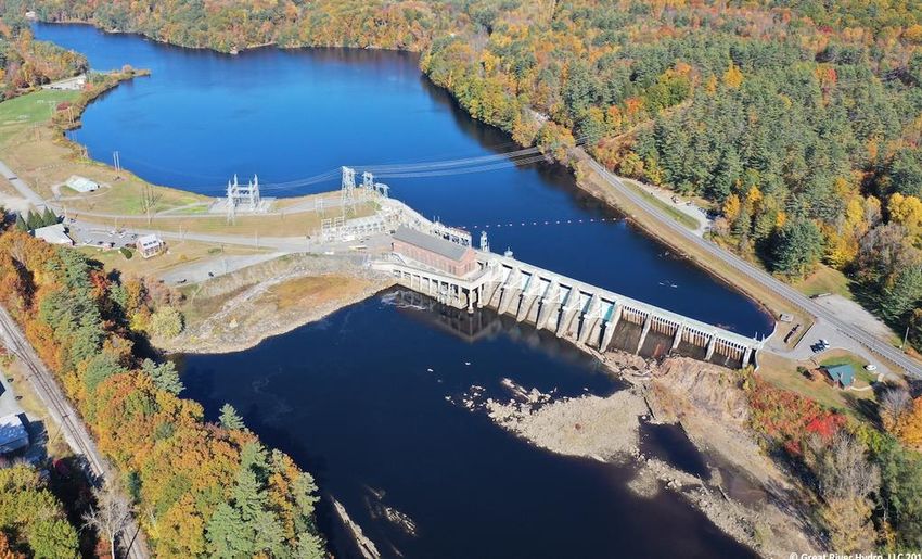
Table of Contents

1.     INTRODUCTION ..................................................................................................................................................... 4
2.     PURPOSE................................................................................................................................................................... 5
3.     TOWN PROFILE ..................................................................................................................................................... 6
4.     PLANNING PROCESS ......................................................................................................................................... 10
     4.1       Public Involvement................................................................................................................................... 11
     4.2       Resources Consulted................................................................................................................................ 13
     4.3       Review of Town Progress, Resources, and Capabilities ............................................................ 13
           4.3a           Previous Plan Period Mitigation Actions ............................................................................. 13
           4.3b           Review of Town Plan ................................................................................................................... 15
           4.3c           Status of Community Resources and Capabilities ............................................................ 15
5.     HAZARD IDENTIFICATION and ASSESSMENT ....................................................................................... 20
     5.1       Hazard Probability of Occurrence and Impact Assessment ..................................................... 20
     5.2       Hazard Profile............................................................................................................................................. 23
           5.2a.          Wildfire .............................................................................................................................................. 26
           5.2b.          Structure Fire .................................................................................................................................. 29
           5.2c.          Inundation & Flash Flooding / Fluvial & Other Erosion .............................................. 35
           5.2d.          Ice Storm & Ice / Extreme Cold ............................................................................................... 50
           5.2e.          High Wind ......................................................................................................................................... 57
           5.2f.          Extreme Heat / Drought ............................................................................................................. 60
           5.2g.          Dam Failure ..................................................................................................................................... 64
6.     MITIGATION PROGRAM .................................................................................................................................. 67
     6.1       Mitigation Goals and Objectives .......................................................................................................... 67
     6.2       Hazard Mitigation/Preparedness Strategies and Actions ........................................................ 68
           6.2a           Changes from Prior Plan ............................................................................................................. 68
           6.3b           Prioritization of Strategies and Actions ............................................................................... 69
     6.3       Plan Monitoring and Maintenance Process .................................................................................... 78
           6.3a           Plan Monitoring Process............................................................................................................. 78
           6.3b           Plan Maintenance Process ......................................................................................................... 79

                                                                                                                                                                                  2
APPENDICES
    Appendix A:
     Map 1: Existing Land Use
     Map 2: Future Land Use
     Map 3: Water Resource Map
     Map 4: Forest Block Map
     Map 5: Downtown Flood Overlay
    Appendix B: Agendas, Sign-In Forms, Public Notice
    Appendix C: Process Flow Chart
    Appendix D: Town Plan Review
    Appendix E: Future Hazard Mitigation Ideas
    Appendix F: Plan Monitoring Forms

                                                        3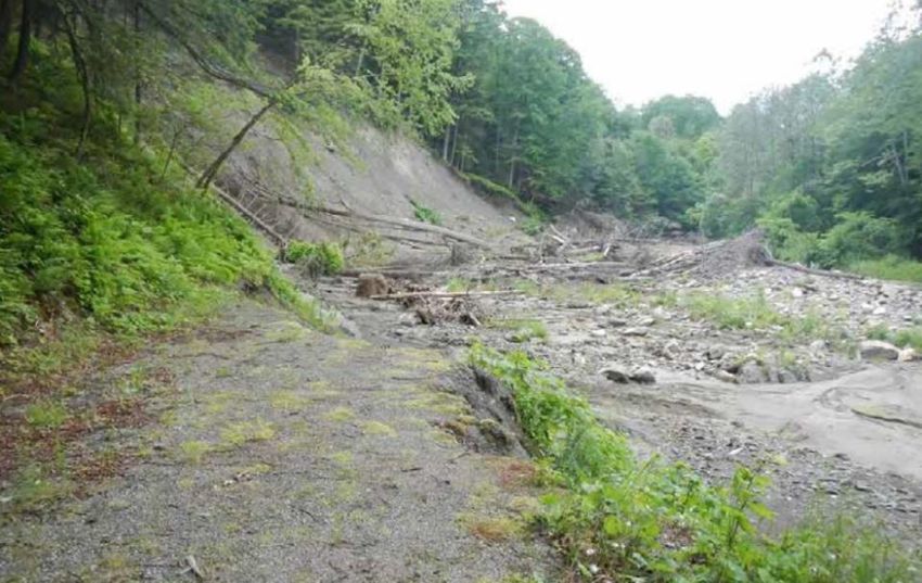
1. INTRODUCTION
This Local Hazard Mitigation Plan is intended to is to assist the Town of Windsor in identifying and
understanding the risks of natural or man-made hazard events to the and providing strategies and actions
that can be taken to improve the resiliency of the local community in the event of a natural or man-made
hazard.

Local Hazard Mitigation Planning is the process of identifying strategies and policies in order to develop a
long-term plan of action that will reduce or remove future risk and losses to a community caused by
natural or man-made hazard events. This planning effort involved an assessment of local capabilities and
resources, an awareness of historical and future hazard occurrences, an understanding of the potential
impacts to life, local economy, infrastructure and the environment; and a determination of vulnerable
areas and assets within the community. These efforts have culminated into a list of actions that can be
found in Table 12 at the end of this plan and are to be monitored for progress over the next five-year
period.

This plan will focus on assessing natural hazards and mitigating actions to minimize the impact of these
hazards on the community and increase the Town’s resiliency to disaster. The Windsor community has
provided input to this plan in the form of local and historic knowledge and experience.

                                                                                               Hazard
                                                                                               Mitigation
                                                                                               Plan
                                                                           What can we do to
                                                                               improve our
                                              What parts of                  resiliency in the
                                             the community                   future given the
                                              were affected                     anticipated
                            How severe have   and what are                 changes in climate?
                          hazard events been our current
                             in the past and vulnerabilities?
                             what was their
                                impact on
        What hazards have       Windsor?
       impacted Windsor in
      the past and what are
      future climate trends
         for the region?

                                                                                                          4
2. PURPOSE
The Federal Emergency Management Agency (FEMA), Vermont Emergency Management (VEM), and
local towns have come to recognize that it is less costly to take action to minimize the impact of natural
hazards than to repeatedly repair damage after a disaster has struck. Hazards cannot be eliminated, but
it is possible to determine what the hazards are and which are more likely to occur and tend to have the
greatest impact on a community. With some research and outreach, a local community can determine
the extent and impact of these hazards and which assets and areas are most at risk. A culmination of
these efforts is a working dynamic list of specific strategies and actions that can be taken to reduce the
impact of these hazards on the community. This plan also recognizes and has identified opportunities for
mitigation measures during all of the other phases of emergency management: preparedness, response,
and recovery.

                                               Increased
                                                Disaster
                                               Recovery
                                                Funding

                                             HAZARD
               Reduced                                                         Reduced
                                            MITIGATION                         Financial
                Hazard
                Impact                      PLANNING                            Losses
                                             BENEFITS

                                               Informed
                                              & Prepared
                                                 Public

                                                                                                        5
3. TOWN PROFILE
The Town of Windsor is a small rural New England town located within Windsor County in southeastern
Vermont. It is bordered by the Towns of Hartland, Weathersfield, West Windsor, and Cornish, New
Hampshire. The Windsor County region is comprised of 24 towns and is the largest county by area in
Vermont, encompassing 977 square miles. It is influenced by both the Connecticut River, which runs
along the eastern edge, and the Green Mountains which dictate the physiology of the western edge of
the                                                                                            region.

Known as the “Birthplace of Vermont”, the Town of Windsor is a relatively small town in terms of land
area, only 20 square miles, with a population of 3,400. The historic buildings in the downtown are
surrounded by outstanding natural assets, including the Connecticut River, Mount Ascutney State Park,
Mill Pond, Lake Runnemede and Paradise Park. A large infrastructure system, built for the expansive
manufacturing industry that thrived in the mid-1900s, serves the more developed parts of Town. Mt.
Ascutney Hospital, the Windsor school system and smaller-scale shopping opportunities in Windsor
serve the surrounding towns.
The Town’s topography is relatively flat land with rolling hills and it is situated with its entire east border
along the high banks of the Connecticut River. The Mill Brook is a tributary of the Connecticut River that
runs through Windsor and feeds the Mill Pond, an 80-acre waterbody just south of downtown that
services one of the Town’s recreation centers. It is impounded by the historic Ascutney Mill Dam,
constructed in 1834. The dam’s stone buttress which had been damaged by Tropical Storm Irene has
been repaired since the prior plan. North of downtown, Kimball Brook and Hubbard Brook feed Lake
Runnemede, which is managed for wildlife conservation and accessed through Paradise Park in
Windsor’s Town forest.

                                                                                                              6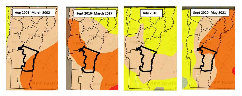
Windsor is served by four state roads which provide a number of alternative evacuation routes. These
major thoroughfares also bring of out-of-state travelers through town on their way to other south
centrally located tourist destinations. The Green Mountain Railroad runs through Windsor on the route
that extends from Bellows Falls to Rutland. Currently the tracks are used mainly for freight traffic,
although an excursion train, the Green Mountain Flyer, runs from Bellows Falls to Ludlow during the fall
foliage season.
Vermont state highways including Routes 44 and 44a along with US Route 5 and Interstate-91 connect
the town with larger population centers to the north and
south. In addition, Bridge Street and County Road are
classified as Class 2 town highways and serve as
important connections to other towns. Bridge Street is
notable as it leads to the historic Cornish – Windsor
Covered Bridge, originally built in 1976, and
reconstructed in 1988. The covered bridge, which spans
the Connecticut River, is the only direct connection
between Windsor and New Hampshire. The bridge is
owned and maintained by the State of New Hampshire.
Land use patterns in Windsor have developed in the
classical New England village pattern with a densely
developed downtown surrounded by more sparsely
developed rural lands. The downtown commercial center
is located near the Connecticut River and is concentrated
along Route 5 with industrial uses nearby. The
downtown is home to many beautiful historic buildings.
Immediately outside of the downtown and to the west of
Route 5 are high- and medium-density residential
neighborhoods, sprinkled heavily with historic structures.
                                                         Beyond these neighborhoods are rural
                                                         residential areas, as well as areas of farmland
                                                         and forest. All of the high-density residential
                                                         areas are served by Town water and sewer
                                                         while areas outside of the downtown are served
                                                         by private wells and on-site septic systems. The
                                                         current zoning map designates uses and areas
                                                         of development which are sufficient to handle
                                                         current development trends. (See Appendix A:
                                                         Map 1 – Existing Land Use)
                                                            Windsor has two sections of town located in the
Industrial zoning district, Windsor Industrial Park (i.e. Artisans Park) north of town and the other to the
far South occupied by construction enterprises. The former Goodyear 60-acre campus, although not in

                                                                                                          7
the Industrial District, is located in the downtown area east of the railroad tracks. Recreational centers
are on the outskirts of the town center and include Lake Runnemede (also known as Evart’s Pond) to the
northwest, used primarily for conservation and known for its natural beauty, mountainous views and
recreational opportunities. To the southwest of
downtown is Mill Pond (also known as
Kennedy Pond) impounded by the historic
Ascutney Mill Dam (also known as Windsor
Upper Dam) or Mill Pond Dam) which is one of
the oldest in the country. The impoundment is
an important summer recreational area for the
town.

Windsor County population had experienced uninterrupted growth since 1950 but had begun to slow in
2000, from 57,481 to 55,275 in 2019. Conversely, over the same period, the median age and household
income for the county have been trending up; now at 48 years of age and $60,987, respectively.
The population of the Town of Windsor has been in decline, falling 18% since 1970, according to the U.S.
Census (See Table 1). Over the same period, the percent of population under 18 years of age has
dropped by more than half while the percent over 65 years of age has almost doubled. Although the
population for Vermont and for Windsor County is generally aging, over the past 20 years, the over 65-
years-of-age population in Windsor has remained steady at, approximately, 21%.1 Median income for
Windsor in 2019 was $49,063, below that of $60,987 for the County. 2

1
    U.S. Census Bureau
2
    U.S. Census Bureau

                                                                                                        8
TABLE 1: Windsor Population and Age Distribution – 1970-20193
Year       1970                    1980            1990            2000            2010             2019
Population 4,158                   4,084           3,714           3,756           3,593            3,392
Age        #               % of    #       % of    #       % of    #       % of    #        % of    #        % of
                           total           total           total           total            total            total
4. PLANNING PROCESS
The local planning process used to develop this hazard mitigation plan follows guidance by the Federal
Emergency Management Agency (FEMA) and Vermont Emergency Management (VEM). The planning
process began in December 2020 with the Windsor Town Manager reaching out to municipal staff and
local volunteers to participate as members of a Hazard Mitigation Committee. A seven-member Hazard
Mitigation Committee was formed to direct the activities of the process with guidance from Mount
Ascutney Regional Commission’s (MARC) Community Development Specialist. All correspondence was
via phone or email and meetings were conducted virtually.
MARC staff had initial discussions with the Town Manager of Windsor to review the overall planning
process. The discussion included the need for town input, the importance of the public participation and
public notice procedure, VEM and FEMA review and approval process, and the timeline to complete the
update. This information was forwarded to Committee also provided to committee members via email
in December.
The Hazard Mitigation Committee was tasked with updating the plan and overseeing the public process.
Committee members include representation from a cross-section of town departments and Boards.
MARC staff conducted the meetings, provided data for the plan update, drafted the plan and presented
a review of the draft plan to the Selectboard during a Selectboard public meeting. Committee Members
and participants are listed below.
• Windsor Town Manager
• Windsor Highway Foreman
• Fire Chief/Emergency Management
• Zoning Administrator
• Community Development Specialist, Mount Ascutney Regional Commission
The Hazard Mitigation Committee members participated throughout the planning process either by
scheduled virtual group meetings or via committee email correspondence and conference calls as
outlined below.
The kick-off meeting with the Hazard Mitigation Committee began with an overview of the process with
a discussion on the purpose of hazard mitigation planning, the planning process and timeline, and the
importance of community outreach and public involvement. Hazard Mitigation Committee members
and meeting schedules were determined at that time and a procedure was discussed on how to engage
the local community to participate given State Covid restrictions that were in place at the time. The
process proceeded with the tasks as depicted in Appendix C: 2021-2026 Windsor Local Hazard
Mitigation Plan Process Flow Chart. The meeting dates and tasks performed are identified in the flow
chart with Sign-in Sheets and Agendas in Appendix B.
Throughout the process members and the public were encouraged to provide information either during
the virtual meetings or through Town website notifications and on the MARC Windsor Hazard Mitigation
10Planning webpage. Public input on past hazard events and the impact of those events on the Town as
recollected was incorporated into the hazard profile section to provide a local perspective and basis for
local data research. Hazard data was updated by MARC staff, presented to the Committee members,
and posted for public review.
Early in the process each hazard was assessed for the probability of future occurrence and the potential
impact each would have on life, infrastructure, the local economy, and the environment. Vulnerable
areas and assets were identified during the hazard assessment as part of the discussion on historical
impact (see Section 5.1: Hazard Probability of Occurrence and Impact Assessment).
As part of the update process, the Hazard Mitigation Committee conducted a review of the status of
prior plan actions and other progress made in mitigation and preparedness (see Section 4.3a: Previous
Plan Period Mitigation Actions). Municipal capabilities and available resources for hazard mitigation
planning and implementation were also discussed and suggestions made for improving effectiveness
(see Section 4.3c: Review of Town Progress, Resources and Capabilities). A thorough review of the
Town Plan policies and recommendations identified common strategies which generated ideas for new
mitigation actions (see Section 4.3b: Review of Windsor Town Plan).
This update is an extensive update to the previous plan and includes a number of revisions and
improvements. The following is a partial list of revisions:
▪ General updates to Town profile and town maps.
▪ Inclusion of an easy-to-read Process Flow Chart to depict the planning process.
▪ Reorganization/restructuring of the plan contents to better reflect required FEMA elements.
▪ Reevaluation of hazards with a new methodology for scoring similar to that of the Vermont
State 2018 Hazard Mitigation Plan to better recognize the integral natural of hazard events and
hazard impacts and how hazards can impact a community in different ways.
▪ Update of hazard data using new data sources and more local data.
▪ Prioritization of mitigation strategies/actions and correlation to plan goals and incorporation of
phasing large projects.
▪ Recognition of specific prior actions completed but not previously identified in prior plan.
▪ Review and integration of new relevant reports and documents.
▪ A formalized Plan Monitoring process to maintain focus on plan goals and to encourage
progress, annual reporting, recording of local hazard events, identification of new vulnerable
assets, and public outreach over the plan period.
4.1 Public Involvement
Due to State Covid restrictions and guidelines, all meetings were held virtually. Three monthly planning
meetings were held, and all were publicly noticed (see Public Notice in Appendix B). The notice was
posted on the Town website and included in the Town’s weekly newsletter, as is customary for the
11Town, and was linked to a dedicated Windsor Hazard Mitigation Planning Update page on the MARC
website. A link to participate in the virtual meetings was offered. The MARC webpage posted the
meeting schedule, agendas and planning documents and materials for public access throughout the
process. The notice and webpage encouraged participation and requested public comment on planning
topics with templates to provide information on hazard events and local impact. The Town Manager was
tasked with keeping the Town Selectboard and relevant commissions abreast of the planning progress
and noticed meetings, and to encourage participation to attending public. Public input received
included:
Public Release of First Draft(to be done)
A first draft was released for public review on July 30, 2021. The Public Review Process included:
o An electronic copy posted on the Town and MARC websites that circulated to individual
members of the Board of Selectmen and Planning Commission, requesting comments
from the local boards and community.
o An electronic distribution made to adjacent towns (Hartland, Weathersfield, West
Windsor) via email to respective Town Clerks with a request to post the draft on their
websites and provide a copy to their Planning Commission and Selectboard members.
o All distributions included the following:
"The Town of Windsor is seeking comment on its 2021-2026 Local Hazard Mitigation Plan draft.
The purpose of this planning effort is to improve Windsor's resiliency to natural hazards through
hazard assessment, recognition of vulnerable assets, and identification of mitigating actions and
strategies to reduce the impact of these hazards on the community. The neighboring town
communities are also invited to attend the Windsor Selectboard meeting of August 24, 2021 at 7
PM for a review of the draft plan. The meeting will be held virtually. Please feel free to forward
any questions or comments to Tom Marsh, Town Manager at tmarsh@windsorvt.org by August
25, 2021. We welcome all input."
• ____ comments were received from the local community during the public release
process and incorporated into the draft.
• ____ comments were received from neighboring communities.
• _____ comments were received during the draft review meeting.
The draft plan was presented by MARC staff during a scheduled Selectboard Meeting on August 24,
2021 following public notice two weeks prior. Subsequently, all comments received were considered
and incorporated into the final draft.
The final plan draft will complete the Vermont State Hazard Mitigation Officer review for referral to
FEMA for Approval Pending Adoption (APA). Following APA, the Town may then adopt the Local Hazard
Mitigation Plan and forward a copy of the adoption resolution for FEMA to complete the plan approval
and adoption process. The final adopted Local Hazard Mitigation Plan will also be posted on the Town
and Mount Ascutney Regional Commission websites and made available at the Windsor Town Offices.
124.2 Resources Consulted
A number of plans, studies, reports, and technical information and web data sources were consulted in
addition to local input during the preparation of this plan. These sources provided data on hazard extent
and historical trends, and ideas for new hazard mitigation actions. A partial listing of these sources
includes the following:
• Local Hazard Mitigation Plan, Town of Windsor, Adopted April, 2016
• Windsor Town Plan, adopted November 12, 2019
• Windsor Zoning Regulations, as amended in March 24, 2015
• 2008 Hubbard Brook Phase I Stream Geomorphic Assessment
• Windsor 2016 Stormwater Report
• Mill Brook River Corridor Plan, 2015
• Tactical Basin Plan for the Black and Ottauquechee Rivers and Connecticut River Tributaries, 2018
• Town of Windsor 2017 Road Erosion Inventory
• MRGP Road Assessment of Hydrologically Connected Segments, 2017-2018
• Windsor Community Flood Study, May 2014
• A Plan For Windsor's Riverfront Community - Connecting The Right Side of the Tracks
• Great River Hydro Plans for Dam Failure: 9/28/2018 Local News reformer.com
• U.S. Census Bureau
• NOAA Storms Event Database
• Vermont Division of Fire Safety
• U.S. Climate Data
• USGS WaterWatch
• FEMA Disaster Declarations
• Vermont Agency of Natural Resources-Flood Ready
• State of Vermont 2018 Hazard Mitigation Plan
• Drought.gov
• Mount Ascutney Regional Commission for GIS mapping data
4.3 Review of Town Progress, Resources, and Capabilities
4.3a Previous Plan Period Mitigation Actions
Table 2 below lists the mitigation and preparedness projects and actions from the previous 2016
Windsor All Hazard Mitigation Plan and indicate the status of each as determined by the Hazard
Mitigation Committee. It can be seen that most of these actions have been completed. Other actions
that are ongoing or uncompleted were reevaluated for inclusion in Table 12: 2021-2026 Mitigation/
Preparedness Strategies and Actions at the end of this document. Others were deemed to be
ineffective or not necessary and have been dropped.
13TABLE 2: Status of Previous Plan Mitigation Actions
2016 MITIGATION ACTION 2021 STATUS
Maintain Basic Emergency Operations Plan ongoing
Maintain ICS/NIMS Training ongoing
Discuss Requirements/ Encourage the installation of
ongoing
adequate fire suppression into new construction
Discussion & Upgrades to Mill Pond dam to meet
Repairs made to Dam Buttress completed
standards
Collect additional hazard vulnerability data for
In progress
inclusion in next plan update
Discuss/Identify Options for Bridge enlargement on
Infeasible
Bridge Street
Enhance fire suppression capabilities ongoing
Make NFIP pamphlets available in town completed
Review Regional Resources List (shared equipment
ongoing
inventory)
Public Outreach: distribute state brochures on fire Completed – Brochures and Digital material
prevention available
Conduct studies to assess vulnerability of critical
completed
facilities to earthquake events
Not completed and removed from list of
Conduct an engineering study of critical facilities to
recommended actions because of low
identify vulnerabilities to high wind
vulnerability and low priority
Public Outreach: distribute FEMA guides and Completed – Brochures and Digital material
brochures available
Additional progress made in reducing hazard risk and improving preparedness since the prior plan:
• In addition to repairs, substantial safety reinforcements were made to further stabilize the stone
buttress and spillway of the historic Ascutney Mill Dam following Tropical Storm Irene (TSI) to
reduce the risk of a dam breach.
• Juniper Hill upgrades have improved the resiliency of the road.
14• Permanent removal of Brook Road Bridge 22 and debris with bank stabilization and a
conservation easement through Upper Valley Land Trust to maintain vacant lots for floodplain
access and sediment storage.
• Debris cleanup of the Goodyear Industrial Campus concrete slab for a solar array install has
reduced the risk of a release of hazardous material debris during future flood events.
• Windsor’s Riverfront Redevelopment Plan highlights the flood hazard risks, includes mapping of
180 structures in Special Flood Hazard Areas and plans for reducing flood risk for neighborhood
communities on the Connecticut River.
• Enhancements were made to expand mutual aid agreements and technical training of EMS
personnel for increased emergency response capability.
4.3b Review of Town Plan
The Windsor Town Plan was updated in 2019 and adopted November 12, 2019. Compared to earlier
plans, the community is making strides in its efforts to address sustainable development, natural
resource conservation, flood resiliency, and hazard mitigation. The current Town Plan includes a more
comprehensive integration of the local hazard mitigation planning and a commitment to implementing
its strategies and actions. Town planning can always benefit from better integration and coordination of
hazard mitigation planning goals and strategies in the planning process. To help achieve this, the last
Town Plan update included a Flood Resiliency Chapter with description of the hazard, vulnerable areas
and recommended goals, policies and strategies.
The Windsor Town Plan has outlined goals, policies and recommendations related to hazard mitigation
which can be found in Appendix D. Upon review, the Hazard Mitigation Committee has identified
mitigation strategies and actions that will meet objectives for both the Town and Hazard Mitigation
Plans. These proposed actions can be found as noted in Table 12: 2021-2026 Mitigation/Preparedness
Strategies and Actions.
4.3c Status of Community Resources and Capabilities
Table 3 is a compilation of community resources and capabilities including town authorities, policies,
and programs, which can be helpful in reducing hazard risk for the community. Each was evaluated for
effectiveness in attaining hazard mitigation goals and for opportunities for improvement. These
resources and capabilities are useful in regulating development location, building design, environmental
conservation, and best management practices to reduce flooding and erosion. They are critical in
providing an effective local emergency response.
Windsor currently participates in the National Flood Insurance Program (NFIP) and will continue to
regulate floodplain use through the Flood Hazard Review which is conducted during the development
review as outlined in the Town’s Zoning Regulations and Flood Hazard Overlay District Boundaries as
shown on the NFIP maps, as amended in March, 2015. These regulations are based on flood elevations
15and floodway limits and data provided by the NFIP Flood Insurance Study and accompanying maps.
Participation status for Windsor can be found on pg. 48.
Continued enforcement of these regulations by the Windsor Administrative Officer will maintain
Windsor’s compliance with the NFIP. The Zoning Administrator is charged with implementing these
regulations and, in concert with the Development Review Board, advising residents on floodplain
development.
TABLE 3: Status of Community Resources and Capabilities
Effectiveness in Opportunities for Improving
Resource Description
implementing HM Goals Effectiveness/Status
Plan for coordinated Effective in addressing Plan can be strengthened to be
town-wide planning development in hazard more effective by better
for land use, municipal areas, including coordinating with LHMP goals
2019 Town Plan
facilities, etc. Updated floodplains. The last and actions in some Town Plan
every 8 years. update incorporated a sections.
flood resiliency section.
State requirement for Effective in providing Opportunities to consider actions
Town Plans as of 2015. guidance to restrict new that meet stated
Identifies flood and development in identified recommendations, policies &
2019 Town Plan fluvial erosion hazard flood hazard, fluvial goals that reduce flood hazard
Addendum on areas and vulnerable erosion, and river corridor risk in vulnerable areas identified.
Flood Resiliency structures. areas, and encourage
Recommends policies floodplain protection and
and strategies to restoration and flood
mitigate risks. emergency preparedness.
Provides access to Effective in providing the Radio communication
Connecticut
dozens of other fire capacity for the Town to standardization will improve
Valley Fire Mutual
departments, in respond within minutes to effectiveness.
Aid System and
addition to the a large-scale emergency in
the Upper Valley
equipment and Windsor.
Fire Mutual Aid
personnel at the local
System
fire station
Basic municipal Effectively outlines VEM updated the LEMP process
Local Emergency procedures for procedures for call-outs, in 2019 to allow towns more
Management emergency response evacuation, etc. planning flexibility and additional
Plan (LEMP) Updated annually. planning resources online at
(adopted 4/2020) VEM/LEMP. No improvements to
be made by Town.
Volunteer LEPCs create an important State is in discussion to move
Local Emergency organization involved partnership between forward with a statewide LEPC
Planning in regional hazard residents, local and transition to (REMC) Regional
Committee 3 mitigation efforts government, and Emergency Management
(LEPC3) industries to protect Committee. The REMCs will act as
communities from all-hazards planning committees
16Effectiveness in Opportunities for Improving
Resource Description
implementing HM Goals Effectiveness/Status
hazardous materials that are regionally organized and
incidents, emergencies, locally controlled. This regional
and disasters. approach will be more effective
for HMP in small towns for
hazards such as flooding.
A planning tool and Effective in providing data Last revised in 2016. No updates
resource to Local and resources to town are planned at this time but state
LEPC 3 All
Emergency Planning first responders is considering expanded use by
Hazards Resource
Committee for towns contractors.
Guide
in emergency
situations
School procedures for Utilizes template provided Recently standardized to improve
emergency response by state; provides a coordination with Municipal Aid
School
checklist of actions for use Programs. Coordination with the
Emergency
by administrators and first LEOP will improve effectiveness.
Response
responders. Effective to
Protocol
reference during
emergency situations.
Town complies with Effective through their Continued implementation of
State Road &
State design and continued implementation State Road standards is critical to
Bridge Standards
construction standards effectiveness. No improvements
(last adopted
for roads and drainage to be made by Town.
7/9/2019)
systems.
State Standards have Effective in controlling Work with regional planners to
been updated to road erosion and actively pursue available funding
include the MRGP to stormwater run-off from opportunities to implement
control runoff and roads with recommended improvements on
drainage on hyrdo- implementation of Best hydrologically connected road
Municipal Roads logically connected Management Practices. segments. Be proactive in
General Permit road segments. Current update requires preparing and annually
(MRGP) Compliance is being prioritization and planned monitoring an implementation
phased in over time. implementation schedule plan for compliance.
of identified road
segments. Provides
funding source for
compliance.
Bridge & Culvert Effective at tracking andProactive planning to incorporate
Infrastructure &
Inventory, updated planning for upgrades to identified needed upgrades
Road
every 3 years. most vulnerable through available clean water and
Maintenance
infrastructure road improvement grant
Programs (last
programs can improve
updated 2020)
effectiveness.
Regulates the division Effective through their Continued updates and
Subdivision
of land, standards for continued implementation enforcement are important for
Regulations
site access and utilities continued effectiveness. No
17Effectiveness in Opportunities for Improving
Resource Description
implementing HM Goals Effectiveness/Status
improvements or updates
planned at this time.
Windsor Zoning Seeks to guide Effective in standardizing Continued updates and
Regulations development in the permitting and review enforcement are important for
(amended conformance with process for development continued effectiveness. Update
3/2015) Town Plan. within a flood hazard area. is planned for 2021.
Provides ability for Covers damage caused by Continue outreach to flood
National Flood residents in flooding and informs vulnerable residents and
Insurance participating residents of flood risk and maintain Town compliance.
Program (NFIP) communities to homeowner tools for
(enrolled acquire flood flood mitigation. Effective
9/28/1979) insurance in ensuring that future
development is safe from
flooding.
Regulates building Effective in meeting fire No improvements to be made by
State Building
construction standards and safety standards for Town.
Code residential and
commercial buildings
Regulates driveway Effective in limiting the Continued enforcement of access
access along town- number of road cuts and permit regulations and
maintained roads and in reducing the potential incorporating Flood Hazard Area
Access Permits
in flood hazard areas for flooding and erosion requirements as updated. No
with culvert size improvements planned by Town
requirements at this time.
Ensures compliance Effective in implementing Effectiveness determined by
Windsor Zoning with zoning codes and zoning bylaws to minimize periodic Zoning Regulation
Administrator flood hazard flood hazard risk updates.
regulations
Regional organization Effective in assisting The RC can improve the planning
working to further towns in Hazard process and investigate additional
Mount Ascutney Emergency Mitigation Planning and sources of historical and
Regional Management and other municipal planning statistical data for identified
Commission Hazard Mitigation efforts and with hazards.
goals. application assistance for
project funding.
Technical Resources
State Program Effective in identifying The Inventory report prioritizes
provides an road sections that are assessed segments and can be
assessment of vulnerable to erosion and used to identify the higher
Windsor MRGP hydrologically suggests Best Practices to priority or most vulnerable
Road Segment connected road improve resiliency and sections.
Inventory (2020) segments for erosion bring segments up to
and requires a local MRGP Standards.
plan for achieving
compliance.
18Effectiveness in Opportunities for Improving
Resource Description
implementing HM Goals Effectiveness/Status
These state funded Identifies and prioritizes This report is most effective when
Town of Windsor reports were road erosion issues and considered for capital budgeting,
Road Erosion produced every few recommended actions infrastructure upgrades and
Inventory Report years to assess site with cost estimates planning. It is no longer produced
(2017) specific vulnerabilities but some identified sites may still
to erosion. be relevant.
2015 Mill Brook These reports provide Recommended actions are Effectiveness can be improved if
Corridor Plan & detailed analyses of prioritized based on these documents are consulted
Hubbard Brook current conditions and effectiveness for for project implementation on a
Stream watershed-wide and improving flood resiliency periodic basis and incorporate
Geomorphic site-specific and water quality in rivers these projects into other town
Study recommendations. and streams planning activities
intended to identify Identifies specific Effectiveness can be improved
flood and erosion mitigation techniques, with a more active and expanded
hazard areas, clarify explains NFIP, identifies distribution effort. May require
Windsor the local flood permit other resources and can small updates upon review.
Community Flood process, and explain serve as an educational
Study (2014) complex flood rules outreach document.
for residents to guide
redevelopment
efforts.
Inundation Flood Identifies specific areas at Effectiveness can be improved if
Emergency Action
Maps are maintained risk from inundation residents are made aware of the
Plans/Maps for
for the Mill Pond and flooding from a dam existence of these plans and can
Ascutney Mill
Connecticut River should it breach. If a dam be better prepared should
Dam (Mill Pond
dams which depict breach is anticipated, this warnings or evacuation be
Dam or Windsor
extent of inundation in can help with evacuation required.
Upper Dam) and
the event of dam plans and can be
Wilder Dam (??)
failure. lifesaving.
An online-map tool Effective at providing a Effectiveness can be improved if
that provides mapping wealth of public the website can be better
data to identify areas information on everything promoted through outreach or
at risk of flood or flood related in a possibly offer an instructional
Vermont Flood
fluvial erosion. community in a very webinar for the local community.
Ready
Provides community concise and organized
risk assessment interactive web portal.
reports and references
for reducing flood risk.
195. HAZARD IDENTIFICATION and ASSESSMENT
The following assessment addresses all of the hazards identified during the hazard analysis. The
probability of occurrence and impact to the town were used to assess the town’s vulnerability to each
hazard and can be found in Section 5.1. Following this assessment, it was determined that only those
hazards that were more likely to occur were further examined for historical occurrence and extent of
impact, and trends and community risk as outlined in Section 5.2.
5.1 Hazard Probability of Occurrence and Impact Assessment
A hazard vulnerability assessment for Windsor began with identifying all possible natural hazards as
addressed in the 2018 Vermont State Hazard Mitigation Plan. The group performed two assessment
exercises, similar to the approach that was used in the State plan. This type of approach was helpful in
that it distinguished between hazard events and hazard impacts. For example, Wind is a hazard impact
from different hazard event types: Hurricanes, Thunderstorms and Winter Storms and Erosion can result
from Tropical Storms, Ice Jams, Thunderstorms or spring melt. This new approach to the assessment
allowed for better focus on the probability and risk of the impact of flooding, for example, rather than
on the weather event itself.
The first exercise was to generate a Hazard Event Probability Score for each hazard event based on the
frequency of historical occurrence and the projected occurrence over the plan period, given expected
changes in climate. These scores are shown in Table 4a: Hazard Events Assessment along with a listing
of possible impacts from each event type.
The second exercise listed all possible hazard impacts and generated a Potential Hazard Impact Score by
considering the potential severity and extent of damage and disruption to the population, property,
public services, the economy and the local natural environment. An overall Hazard Assessment Score
was calculated by multiplying the Potential Hazard Impact Score times the Hazard Event Probability
Score. The results are shown in Table 4b: Hazard Impact Assessment. The methodology used for each of
these exercises is detailed below each table.
A discussion of each of the hazards is given in the proceeding Subsections 5.2a through 5.2g. Only
natural hazards were further evaluated for this update. The Hazard Profile and Assessment in Section 5
provided a basis for the selected implementation strategies and actions listed in Table 12: 2021-2026
Mitigation/Preparedness Strategies and Actions.
20TABLE 4a: Hazard Events Assessment
Probability Event
Historical Types of Potential Hazard Impacts from the
Hazard Events of Future Probability
Occurrence Event
Occurrence Score
Score Range 1-4 1-4 Avg.
Inundation & Flash Flooding, Erosion & Fluvial
Rainstorm/Thunderstorm/
4 4 4.00 Erosion, Slope Failure, High Wind, Lightning,
Microbursts
Hail, Wildfire
Inundation & Flash Flooding, Erosion & Fluvial
Hurricane/Tropical Storm 1 2 1.50
Erosion, Slope Failure, High Wind
Heavy Snow, Ice, High Wind, Transportation
Winter Storm 3 3.5 3.25
Incident, Structure Fire
Increases vulnerability to Wildfire, Erosion,
Drought 2 3 2.50
Slope Failure, Invasive Species
Increases vulnerability to Erosion and Slope
Wildfire 1 2 1.50
Failure
Ice Jams 2 2.5 2.25 Inundation, Fluvial Erosion
Extreme Cold 3 3 3.00 Increases vulnerability to Structure Fire
Increases vulnerability to Drought and
Extreme Heat 2 3 2.50
Wildfire
Earthquake 1 1 1.00 Slope Failure
Tornado 1 1 1.00 Wind, Hail
Dam Failure 1 1 1.00 Inundation, Erosion, Fluvial Erosion, Landslide
Infectious Disease 1 3 2.00
Historical Occurrence: Relative frequency of occurrence experience in the past 10 years
1 = Rarely 0 to 2 occurrences
2 = Few Occurrences 2 to 5 occurrences
3 = Several Occurrences 5 to 9 occurrences
4 = Annual Occurrence 10 or more occurrences or typically experienced at least once annually
Probability of Future Occurrence: Probability of occurrence over next 10 years.
1 = Not Likely Not expected to occur
2 = Occasionally Could plausibly occur at least once
3 = Likely Likely to occur in any one year
4 = Highly Likely Highly likely to occur at least once in any one year
Types of Hazard Impacts: Examples of types of impacts should a hazard event occur.
Fluvial Erosion/Erosion Landslides/Slope Failure Inundation Flooding
Ice/Ice Jam Heavy Snow Hail
Extreme Heat/cold Drought Wildland/Structural Fire
High Wind Lightning Infectious Disease
Invasive Species Transportation Incidents
Water Supply Contamination
21TABLE 4b: Hazard Impact Assessment
Potential Hazard Impact (score 1-4) Hazard
Hazard Impacts Probability Assessment
Infrastructure Life Economy Environment Avg. Score**
Score*
Inundation / Flash
4 2 2 2 2 2.0 8.0
Flooding
Fluvial Erosion/
3 2 1 1 2 1.5 4.5
Erosion
Slope Failure 1 1 1 1 1 1.0 1.0
Ice 4 3 2 1 1 1.75 7.0
Heavy Snow 3 1 1 2 1 1.25 3.8
High Wind 3 2 2 1 1 1.5 4.5
Hail 1 1 1 1 1 1.00 1.0
Lightning 2 1 1 1 2 1.25 2.5
Extreme Cold 4 1 2 1 1 1.25 5.0
Extreme Heat 4 1 2 1 1 1.25 5.0
Wildfire 4 1 1 1 1 1.00 4.0
Structure Fire 4 1 2 1 1 1.25 5.0
Earthquake 1 1 1 1 1 1.0 1.0
Drought 3 1 2 1 2 1.50 4.5
Dam Failure 1 4 3 4 4 3.75 3.8
Invasive Species 3 1 1 1 2 1.25 3.8
Infectious Disease
2 1 2 3 1 1.75 3.5
Outbreak
Potential Impact: Probability of a Significant Impact defined as ‘Severity and extent of damage and disruption to
population property, environment and the economy’
1 = Negligible Isolated occurrences of minor property and environmental damage, minor disruption of critical facilities
and infrastructure, potential for minor injuries, no to minimal economic disruption
2 = Minor Isolated occurrences of moderate to severe property and environmental damage, brief disruption of
critical facilities and infrastructure, potential for injuries, and minor economic disruption
3 = Moderate Severe property and environmental damage on a community scale, temporary shutdown of critical
facilities, injuries or fatalities, short-term economic impact
4 = Major Severe property and environmental damage on a town-wide or regional scale, shutdown of critical
facilities, and/or multiple injuries or fatalities, significant economic impact
225.2 Hazard Profile
While the assessment scores in Table 4b are not intended to prioritize hazard risk, they can be used to
get a general sense of which hazards are of greatest concern to the Windsor community. The Hazard
Mitigation Committee had decided that only those natural hazards which scored a ‘4’ or greater out of a
possible 16 were considered for evaluation and are profiled in this plan. These are highlighted in the
Table 4b above. For other hazards, the HMC decided that these be excluded given that the likelihood of
occurrence is either very low with no account of recent local occurrence or the hazard impact is very
isolated or low.
Subsections below provide additional detail of each of the hazards determined to be most relevant to
the Town of Windsor. and include:
• a description of the hazard and its general impact on a community;
• a discussion of historical local occurrences and extent of the hazard impact based on available
data; and
• hazard trend and determination of populations and community assets at risk.
The following hazards were determined to be of lower priority for reasons noted below. For more
information on these hazards, the reader is directed to the 2018 Vermont State Hazard Mitigation Plan.
Hail and Lightening do occur but very rarely and have not resulted in reported damage to the Town
of Windsor. These incidents are very difficult to predict or mitigate and can only be addressed through
preparedness and effectiveness of emergency response. Regional weather warnings and safety
measures are issued when an extreme event is projected.
Although Earthquakes can be significant hazards, the likelihood of occurring in Windsor over the plan
period would be negligible for New England per the Vermont State Hazard Mitigation Plan. Local
regional recollection of this type of hazard occurring has been the sensation of minor tremors felt from
distant events.
Infectious Disease would likely be addressed at a state or nationwide scale. However, additional
evaluations could be done for local opportunities to improve preparedness for emergency response and
supplies. This is recognized as a secondary hazard with a new action item in Table 12, but the hazard is
not profiled in this local plan.
Heavy Snow events are anticipated during the winter season and most small towns, like Windsor,
have the equipment and local capacity to clear and manage average annual snow loads of over 85
inches for southern Vermont.
Invasive Species is a recognized hazard and has increased since the ravaging of Tropical Storm Irene
in 2011. Japanese Knot Weed has claimed the barren riverbanks and its shallow root system make this
invasive prone to wash out during high water flow events causing blockage under bridges and in
23culverts. However, removal from barren sections of riverbed is not permitted and berm removal and
restoration to improve floodplain access would also include removal and revegetation with native
species. Infestations of local plant species can be considered here in future planning as the impacts of
the Emerald Ash Borer and White Pine Needle Disease progress with regional mitigation efforts. This is
recognized as a secondary hazard with risk to town infrastructure and residents. A new action item for
this is included in Table 12, but the hazard is not profiled in this local plan.
Slope Failure is a real threat along the banks of the Williams River as a result of the severe erosion
caused by Irene. Should they fail and block an underpass, significant isolated flooding could occur. The
scope to mitigate this hazard is beyond the jurisdiction and capability of the Town and is not covered
here. Flood mitigation efforts upstream may help to reduce this risk.
Dam Failure was assessed as having a low probability of occurrence since repairs were made to the
Mill Pond Dam buttress in 2018. However, this hazard continues to be profiled in hazard mitigation
planning due to the potential for a catastrophic impact on the community (See Section 5.2g).
Windsor is a small rural town, and much of the town-specific data for these natural hazards does not
exist. Previous occurrence hazard data specific to Windsor has been provided where available. However,
where no town-specific data exists, the most relevant available data or information has been provided,
such as county, regional or state data, or data from a neighboring town. Windsor will strive to improve
the recording and maintenance of local hazard data and has included this as part of the monitoring
process for this plan.
Changes from Prior Plan Hazard Assessment
A comparison was made to the prior plan’s hazard assessment with notable changes listed below.
Changes in the methodology used for the hazard assessment exercise and recent and trending climate
extremes in wind, temperature and precipitation events are reflected in these differences.
• Flooding and related erosion continue to be a priority given the Town’s geographical
characteristics and historical and projected probability of occurrence and impact. However,
these hazards were assessed as one in the prior plan. They are now assessed separately to
better differentiate the risk of erosion due to river or inundation flooding or stormwater flow.
• Winter Storm related hazards were combined in the prior plan. This update identifies ice,
extreme cold and heavy snow as separate hazards. This is due to changes in climate that have
increased the impact of ice and extreme cold while the impact from heavy snow has been a low
priority and is not expected to change.
• Ice from winter storm events has become a more frequent occurrence, due to a trend towards
more extreme variations in temperature during the winter season, and is identified separately
from other winter snow events (extreme cold and heavy snow) in this update. This in turn
increases the risk of transportation incidents on major throughfares through town and of
downed powerlines and structure fire incidents.
24• Extreme Heat and Extreme Cold have increased in priority primarily due to an increase in
probability of occurrence and duration of events with climate change. The aging of Windsor’s
residents, a more vulnerable population, was also a consideration.
• High Wind is now identified separately as a significant hazard impact from thunderstorms,
winter storms, other severe weather events, and winds without precipitation. Together these
events have a high probability of occurrence and prevalence of higher wind gusts.
• Drought is now recognized as a notable and increasing risk to the community with more
frequent extended periods of extreme heat and variability in precipitation events.
• Infectious Disease Outbreak has been identified as a hazard risk due to the recent COVID-19
pandemic experience. Impact to the community from this type of hazard is widespread and
recovery is long. The potential of a new pandemic or likelihood of the continuation of COVID-19
during the plan period exists but was determined to be low.
• Plant Infestations due to climate change is beginning to gain recognition. While more
information is needed, the Town recognizes that this could become a hazard for town roads and
infrastructure.
The types of hazards having the greatest impact on a regional basis can be gleaned from Table 5, a
listing of FEMA Disaster Declarations for Windsor County since 1990. It can be seen from this table that
these are typically severe storms with heavy rains that cause flooding. Severe Winter Storms also occur;
however, harsh winters are a ‘way-of-life’ in Vermont and the Windsor Town Highway Department is
accustomed to operating in heavy snows and low temperatures. (deleted line)
TABLE 5: Federal Disaster Declarations for Windsor County VT4
Federal Disaster Declarations: Windsor County 1970 – 2020(current)
FEMA Disaster Number Date of Declaration Description Date Occurred
DR-4532-VT April 8, 2020 Vermont COVID-19 1/20/2020 (cont)
EM-3437 March 13, 2020 Vermont COVID-19 1/20/2020 (cont)
DR-4445-VT June 14, 2019 Severe Storms and Flooding 4/15/2019
4330 August 16, 2017 Severe Storms and Flooding Need to complete
4207 February 3, 2015 Severe Winter Storm
4140 August 2, 2013 Severe Storms and Flooding
4022 September 1, 2011 Tropical Storm Irene
1790 September 12, 2008 Severe Storms and Flooding
1715 August 3, 2007 Severe Storms and Flooding
1698 May 4, 2007 Severe Storms and Flooding
1488 September 12, 2003 Severe Storms and Flooding
1336 July 27, 2000 Severe Storms and Flooding
1307 November 10, 1999 Tropical Storm Floyd
4
FEMA Disasters Declaration Website
251228 June 30, 1998 Severe Storms and Flooding
1101 February 13, 1996 Storms and Flooding
938 March 18, 1992 Flooding, Heavy Rain, Ice
Jams
Probability of Occurrence: 4.0
5.2a. Wildfire Average Hazard Impact: 1.0
Hazard Assessment Score: 4.0
Wildfire was identified as a notable hazard for the Town primarily because of the high probability of
occurrence, although the impact of fire incidents is typically isolated. Assessment Score: 5.0
Wildfires, which for discussion here include forest, brush, crop or grassland fires, are defined as ‘An
uncontrolled burning of woodlands, brush or grasslands.” 5 While relatively uncommon within Vermont
and the Town of Windsor, large wildland fires are always a threat particularly for rural communities
with large tracts of forested and vegetative land and have the potential to damage structures and
utilities and croplands. A major wildfire can leave a large amount of scorched and barren land
susceptible to erosion for many years, particularly on steep slopes and ridgelines.
5
2020 Vermont State Hazard Mitigation Plan
26You can also read