HARRISDALE ACTIVITY CENTRE PLAN - NICHOLSON ROAD, HARRISDALE - STOCKLAND

Page created by Laura Hoffman
 
CONTINUE READING
HARRISDALE ACTIVITY CENTRE PLAN - NICHOLSON ROAD, HARRISDALE - STOCKLAND
HARRISDALE
     ACTIVITY
     CENTRE PLAN
     NICHOLSON ROAD,
     HARRISDALE

PREPARED FOR

STOCKLAND
JULY 2020
HARRISDALE ACTIVITY CENTRE PLAN - NICHOLSON ROAD, HARRISDALE - STOCKLAND
URBIS STAFF RESPONSIBLE FOR THIS REPORT WERE:
Director                    Tim Dawkins
Associate Director          Sean Morrison
Senior Consultant           Emma Dunning
Project Code                PA1310

© Urbis 2020

This publication is subject to copyright. Except as permitted under
the Copyright Act 1968, no part of it may in any form or by any means
(electronic, mechanical, photocopying, recording or otherwise) be
reproduced, stored in a retrieval system or transmitted without prior
written permission. Enquiries should be addressed to the publishers.

URBIS.COM.AU
HARRISDALE ACTIVITY CENTRE PLAN - NICHOLSON ROAD, HARRISDALE - STOCKLAND
CONTENTS

1.0 IMPLEMENTATION                         12
1.1   ACTIVITY CENTRE PLAN AREA            13
1.2   OPERATION                            13
1.3   STAGING                              13
1.4   SUBDIVISION AND DEVELOPMENT
      REQUIREMENTS                         13
      1.4.1   Activity Centre Objectives   13
      1.4.2   Precincts and Objectives     14
      1.4.3   Land Use Permissibility      15
      1.4.4   Other Controls               15
1.5   LOCAL DEVELOPMENT PLANS              19
1.6   OTHER REQUIREMENTS                   19
1.7   ADDITIONAL INFORMATION               19
1.8   VARIATIONS                           19

2.0 EXPLANATORY REPORT                     22
2.1   PLANNING BACKGROUND                  22
      2.1.1   Introduction and Purpose     22
      2.1.2   Land Description             26
      2.1.3   Planning Framework           32
2.2   CENTRE VISION AND FORM               38
      2.2.1   Vision and Overview          40
      2.2.2   Role in Hierarchy, Size
              and Uses                     42
      2.2.3   Urban Form                   44
      2.2.4   Movement Network             50
      2.2.5   Sustainability               52
      2.2.6   Implementation and Staging   53
2.3   TECHNICAL STUDIES/APPENDICES INDEX   55
HARRISDALE ACTIVITY CENTRE PLAN - NICHOLSON ROAD, HARRISDALE - STOCKLAND
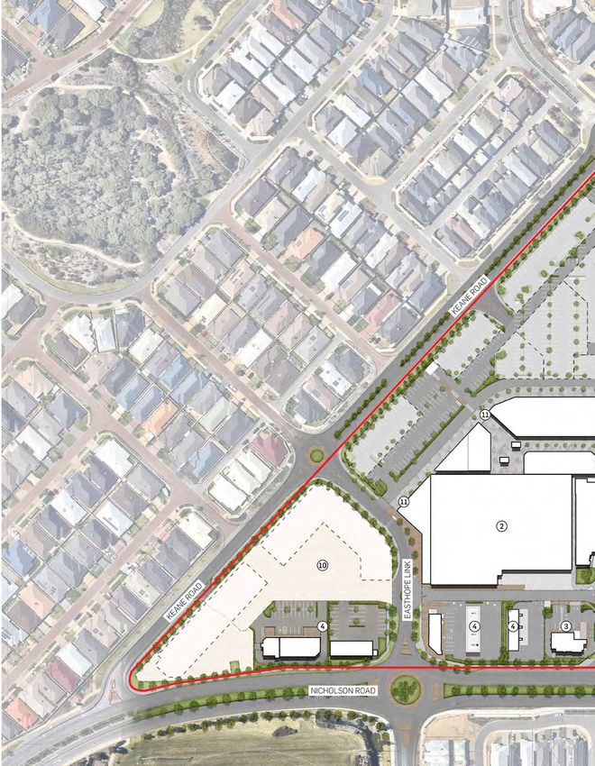
TABLE OF AMENDMENTS
Amendment No.   Summary Of The Amendment   Amendment Type   Date Approved By Wapc
HARRISDALE ACTIVITY CENTRE PLAN - NICHOLSON ROAD, HARRISDALE - STOCKLAND
EXECUTIVE
SUMMARY
The Harrisdale activity centre plan will facilitate the        ▪   Continued development of Yellowwood Avenue as the
ongoing development of the Harrisdale district centre for          activity centre’s main street, with highly active edges,
the growing locality in which it is sited.                         accommodating retail, commercial and entertainment
                                                                   land uses.
Located at the apex of Nicholson Road and Keane Road, the
centre has been contemplated and provided for in a range
                                                               ▪   Car-based retail and commercial uses along
of higher-level planning documents, including SPP4.2 –             Nicholson Road.
Activity Centres for Perth and Peel (SPP4.2) and the North
                                                               ▪   A variety of potential residential development sites,
Forrestdale Stage 1 (‘Central’) local structure plan.              both for short-term and long-term development.
                                                               ▪   Consolidated car parking areas.
The City of Armadale Town Planning Scheme No. 4 (TPS           ▪   Highly legible, well-designed pedestrian linkages to
4) zones all lots within the activity centre as District
                                                                   connect all parts of the activity centre.
Centre, and the City of Armadale Local Planning Strategy
contemplates the activity centre growing substantially
                                                               ▪   Guidance and protections for the longer-term
from its current size.                                             development of the activity centre.

This activity centre plan supersedes and replaces              This activity centre plan, as required by the relevant clauses
the Newhaven District Activity Centre Structure Plan           of the deemed provisions, provides the primary land use,
(NDACSP). The NDACSP restricts the primary lot in the          built form and strategic planning controls for the Harrisdale
activity centre to 12,000sq.m NLA. Existing development in     activity centre, and is to be given due regard in the
the activity centre, which includes the Stockland Harrisdale   consideration of development and subdivision applications
shopping centre, already exceeds that cap. This activity       by the relevant determining authority.
centre plan removes the cap, and provide for ongoing           The activity centre already has a number of minor
expansion of the activity centre in a coordinated manner.      developments approved and set to commence imminently,
This activity centre plan is made pursuant to TPS 4,           however ‘major development’ (as defined by SPP4.2) in
including the deemed provisions for local planning schemes     the form of substantial additions to the existing shopping
of the Planning and Development (Local Planning Schemes)       centre, are likely to occur in the short term (i.e. less
Regulations 2015 (the deemed provisions).                      than 5 years). Further development will take place per
                                                               market demand.
The planning for this activity centre has been led by
Stockland, as sole landowner of the activity centre (sans      Structure planning and subdivision works have already
road reserves), in consultation with the Department of         planned for the delivery of relevant services, infrastructure
Planning/WA Planning Commission (DoP/WAPC), and the            and roads that will support the activity centre – with all
City of Armadale (the City).                                   public roads within and adjacent to the activity centre
                                                               having already been constructed.
The activity centre is planned to provide:
                                                               The Harrisdale activity centre plan will facilitate the
▪  A shopping centre that will expand from its current
                                                               provision of a district centre to service the rapidly emerging
   approximately 12,000sq.m NLA to over 20,000sq.m
                                                               surrounding residential community, in a manner and form
   NLA in the life of this activity centre plan – including
                                                               consistent higher level planning documents, and the
   the addition of a discount department store, and likely
                                                               direction of the City and the DoP/WAPC.
   larger in the longer term.
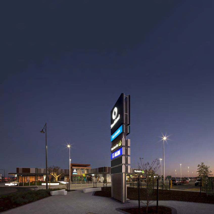
HARRISDALE ACTIVITY CENTRE PLAN - NICHOLSON ROAD, HARRISDALE - STOCKLAND
ITEM                                       DATA

 Total area covered by the structure plan   11.72ha.

 Area of each land use proposed:            Residential – 2.24ha.
                                            Commercial – 6.28ha.
                                            Consolidated car parking area – 3.2ha.

 Total estimated lot yield                  ~140 residential lots (freehold or strata).

 Estimated number of dwellings              ~140.

 Estimated residential site density         20+ dwellings per gross hectare within walkable catchment.

 Estimated population                       ~220.
                                            ~2,100+ within walkable catchment (existing).

 Number of high schools                     0.

 Number of primary schools                  0.

 Estimated commercial floor space           ~27,000sq.m NLA including ~19,000sq.m of shop-retail NLA.

 Estimated area and percentage of public    0ha, 0%
 open space given over to:
 • Regional open space
 • District open space
 • Neighbourhood parks
 • Local parks

Table 1     Activity Centre Plan Overview
HARRISDALE ACTIVITY CENTRE PLAN - NICHOLSON ROAD, HARRISDALE - STOCKLAND
PART ONE
IMPLEMENTATION
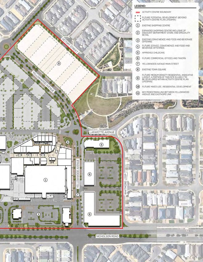
HARRISDALE ACTIVITY CENTRE PLAN - NICHOLSON ROAD, HARRISDALE - STOCKLAND
LEGEND

                                                                                                                                                                                                                                                                           Activity Centre Boundary (11.72Ha)

                                                                                                                                                                                                                                                                 PRECINCTS
                                                                                                                                                                                                                           Jim and Alma
                                                                                                                                                                                                                             Baker Park                                    Retail Core Precinct (5.92Ha)
               D

                                                                                                                                                                                                                                                                           Convenience/Service Commercial Precinct (1.09Ha)
           A
          RO
     HT

                                                                                                                      ET
    G

                                                                                                                     E
                                                                                                                 R
                                                                                                                                                                                                                                                                           Mixed Use/Residential Precinct (2.24Ha)
 RI

                                                                                                              ST
W

                                                                                                         ID
                                                                                                      LL
                                                                                                  PA                                                                                                                                                                       Main Street Commercial Precinct (1.18Ha)
                                                                                                                                                                H
                                                                                                                                                            C
                                                                                                                                                           A

                     Piara Waters                                                                                                                PP
                                                                                                                                                      RO                                                                                                         LAND USE
                                                                                                                                                A
                    Cricket Pavilion
                                                                                   R80-100
                                                                                                                                 IN
                                                                                                                                        G
                                                                                                                                                                                                                                                                           Concentrated Car Parking Area (3.2Ha)
                                                                                                                               PW
                                                                                                                             LA                                                                                                                                            (potential long term development opportunities)

                                                                                                                                                                                                                                                                           Primary Service Area
                                                                                                                                                                                                                                                                           R-Code

                                                                                                                                                                                  Y
                                                                                                                                                                                                                                                                 R80-100

                                                                                                                                                                                 A
                                                                                                                                                                                W
                                                                                                                                                                       N
                                                                                                                         *

                                                                                                                                                                      VE
                                                                                                                                                                    RA
                                                                                                  K
                                                                                                                                                                                                                                                                 OTHER

                                                                                                LIN
                                                  BVD
                                             AY
                                       BRO
                                          ADW
                                                                                  EASTHOPE
                                                                                                                                                                                                                                                                           Town Square

                                                                                                                                                                                                               ET
                                                                                                                                                                                                           RE
                                                                                                                                                                                                         ST
                                                                                                                                                                       KE

                                                                                                                                                                                                                                                                   **      Landmark Building
                                                                                                                                                                            A
                                                                                                                                                                             N

                                                                                                                                                                                                     A
                                                                                                                                                                                 E

                                                                                                                                                                                                   N
                                                                                                                                                                                                 A
                                                                                                                                                                                               LT
                                                                                                                                                                                     RO

                                                                                                                                                                                              BE
                                                                                                                                                                                                                                                                           Landmark Feature
                                                                                                                                                                                       A
                                                                                                                                                                                          D

                                                                                                                                                                                                                                                                           Secondary Building Emphasis

                                                                                                                                                                                                                                                                           Building Orientation
                                                                   ROAD

                                                                                                                                                                                                                                                            D
                                                                                                                                                                                                                                                                           Primary Main Street

                                                                                                                                                                                                                                                           BV
                                                                  NICHOLSON
                                                         LOOP

                                                                                                                                                                                                                                                      LD
                                                                                                                                                                                                                                                      IE
                                                                                                                                                                                                                                                   EF
                                                                                                                                                                                                                                                                           Secondary Main Street

                                                                                                                                                                                                                                                  C
                                                                                                                                                                                                                                                 RA
                                                                                                                                                                                                                                             G
                                                         HOBSON

                                                                                                                                                                                                                                                                           Indicative Major Vehicle Access *

                                                                                                                                                                                                                                                                           Private Service Road

                                                                                                                                                                                                                        UE
                                                                                                                                                                                                                       N
                                                                                                                                                                                                                     VE
                                                                                                                                                                                                                                                                           Key Pedestrian Linkage

                                                                                                                                                                                                                    A
                                                                                                                                                                                                               D
                                                                                                                                                                                                             O
                                                                                                                                                                                                           O
                                                                                                                                                                                                                                                                           Indicative Pedestrian Linkages

                                                                                                                                                                                                         W
                                                                                                                                                                                                       W
                                                                                                                                                                                                     O
                                                                                                                                                                                                   LL
                                                                                                                                                                                               YE
                                                                                                                                                                                                                                                                           Indicative Bus Stop Location
                                                                                                                                                                                                                    R80-100

                                                                                                                           *                                                                                                                                     FRONTAGES

                                                                                                                                                                                                                                            ET
                                                                                                                                                                                                                                       RE
                                                                                                                                                                                                                                                                           Active Frontage

                                                                                                                                                                                                                                       ST
                                                                                                                                                                                          *
                                             YELLOWWOOD AVE
                                                                                         YELLOWWOOD

                                                                                                                                                                                                                                  RY
                                                                                                              AVENUE

                                                                                                                                                                                                                              TO
                                                                                                                                                                                                                             C
                                                                                                                                                                                                                             VI                                            Semi Active Frontage

                                                                              *
                                                                                                                                    LAFAYETTE

                                                                                                                                                                                                                                                                           Attractive Frontage
                                                                                                                                                                       Public
                                                                                                                                                                                                                                                                           Movement Frontage
                                                                                                                                      AVE

                                                                                                                                                                     Open Space

                                                                                                                                                                                                                                                                           HV Powerline
                                                                                    WHITMORE   LOOP

                                                                                                                                                                                                                                                                   *     All site access arrangements are subject to a Transport
                                                                                                                                                                                                                                                                         Impact Assessment at Development Application stage

                   ACTIVITY CENTRE PLAN MAP                                                                                   DATA SOURCE
                                                                                                                              SLIP/LANDGATE
                                                                                                                                                                                                                                                                CLIENT                                                 PROJECT NO.
                                                                                                                                                                                                                                                                                                                       PA1310
                                                                                                                                                                                                                                                                                                                                     DATE
                                                                                                                                                                                                                                                                                                                                     10.07.2020
                   HARRISDALE ACTIVITY CENTRE - NICHOLSON ROAD, HARRISDALE                                                    PROJECTION
                                                                                                                                                                                                                                                                STOCKLAND                                              DRAWING NO.   REVISION
                                                                                                                              MGA94, ZONE 50                                                                                                                                                 1:2500 @ A3
                                                                                                                                                                                                                                                                                                           25   50 m   03            F
1.0 IMPLEMENTATION
1.1            ACTIVITY CENTRE                                  1.4            SUBDIVISION AND
               PLAN AREA                                                       DEVELOPMENT
This activity centre plan applies to the Harrisdale activity
centre, at the intersection of Nicholson Road and Keane
                                                                               REQUIREMENTS
Road, Western Australia.                                        1.4.1          ACTIVITY CENTRE OBJECTIVES
The activity centre plan applies to all areas within the        Development in the activity centre plan area shall align with
boundary identified on the activity centre plan map.            the following objectives:
                                                                ▪   The Harrisdale activity centre is to offer the local
1.2            OPERATION                                            community a high-quality, retail-focused mixed-use
                                                                    district centre development.
This activity centre plan comes into effect on the day it is    ▪   A main street is to be provided on Yellowwood Avenue
approved by the WAPC, the date of which is outlined on              between Nicholson Road and Lafayette Avenue. This
the endorsement page. As per the deemed provisions from             street will be a major focus of activity in the centre,
the date of endorsement this activity centre plan is to have        and will be treated with high quality landscaping and
effect for a period of 10 years, unless otherwise determined        activated frontages.
by the WAPC.                                                    ▪   Shop-retail activity is to be concentrated between
Unless otherwise specified, the words and expressions               Yellowwood Avenue and Easthope link to agglomerate
used in this activity centre plan shall have the respective         retail activity.
meanings given to them in TPS 4.                                ▪   Community and other non-retail, commercial land uses
Nothing in this activity centre plan is to be interpreted as        are to be accommodated in the centre to ensure there is
limiting clause 4.5 of TPS 4 which allows for variations to         a diversity of land uses.
site and development standards and requirements.
                                                                ▪   The centre is to accommodate safe and pleasant
                                                                    pedestrian and cyclist internal movement, and
Nothing in this activity centre plan is to be interpreted           connections to surrounding areas. Pedestrians and
as limiting clause 43 of the deemed provisions that                 cyclists should be able to travel within the centre
outlines that a decision-maker for an application for               between Yellowwood Avenue and Easthope Link in a
development approval or subdivision approval in an area             direct and convenient manner.
that is covered by an activity centre plan is to have due       ▪   Surrounding and internal roads, intersections and
regard to, but is not bound by, the activity centre plan when
                                                                    crossovers are to be designed to allow for the safe and
deciding the application.
                                                                    efficient movement of vehicles to and from the centre.
This Activity Centre Plan supersedes the Newhaven District      ▪   Development is to be designed to present well to street
Activity Centre Structure Plan to the extent of the structure       frontages and public spaces to facilitate a viable,
plan boundary.                                                      enduring and high-quality centre.
                                                                ▪   Development within the life of the activity centre plan

1.3            STAGING                                              should be undertaken with consideration of the long-
                                                                    term development potential of the centre
Further development in the activity centre plan area can
be progressed in the near term, as services are already
available, and the road network within and surrounding the
activity centre has already been constructed.
The staging of future commercial and residential
components will take place in line with market demand,
with further discussion of potential staging of development
outlined in part two of this activity centre plan.
1.4.2                 PRECINCTS AND OBJECTIVES
As outlined on the activity centre plan map, the activity centre plan area is divided into precincts. In addition to the overall
activity centre objectives, development in each of the precincts should respond to the precinct vision statement and
objectives in Table 2.
Table 2             Precinct Vision and Objectives Table
                                        CONVENIENCE/
             MAIN STREET                SERVICE
             COMMERCIAL                 COMMERCIAL                                                      MIXED USE/ RESIDENTIAL
             PRECINCT                   PRECINCT                 RETAIL CORE PRECINCT                   PRECINCT
             This precinct will         This precinct will       This precinct will accommodate         This precinct will provide for a
Vision

             accommodate the            predominantly            a mix of retail and commercial         range of mixed use, small scale
             southern portion of the    accommodate a            land uses in a shopping centre         commercial and residential uses.
             primary main street,       mix of car-based         environment – enclosed and             The southern portion of
             with a mixture of          commercial uses like     unenclosed.                            the precinct will likely be
             commercial buildings       Fast Food Outlet,        Smaller scale, active uses are to      predominantly residential with
             fronting Yellowwood        Convenience Store        be concentrated on Yellowwood          the likely development being
             Avenue.                    and Service Station.     Avenue with secondary                  high density single residential
             The precinct should        Built form in this       concentration facing east along        dwellings or small-scale multi-unit
             accommodate a mix          precinct responds        the north-south key pedestrian         development.
             of commercial uses,        to the uses to           linkage through the precinct.          Residential and commercial
             such as Tavern, Child      ensure it is fit for     The precinct will include some         land uses are encouraged to be
             Care Premises, Offices     purpose, resulting       large format retail uses (including    developed in an integrated, mixed-
             or Medical Centre, to      in standalone            supermarket/s, a discount              use format. Alternatively, where
             promote visitation and     buildings, ‘drive        department store, and mini             uses are not integrated, residential
             activity on the main       through’ elements        majors), and a consolidated area       development should incorporate
             street.                    and parking directly     for car parking in the eastern         adaptable dwelling design to
                                        adjacent buildings.      portion of the precinct.               allow transition to mixed use over
             Built form will be
             concentrated along         A dedicated precinct                                            time and contribute to the semi-
             Yellowwood Avenue          for these types                                                 active frontage on Easthope Link.
             with parking generally     of uses, along                                                  Commercial development should
             located behind the         Nicholson Road,                                                 be designed in a manner which
             built form in order to     ensures that these                                              reflects the mixed use/ residential
             facilitate activity and    car-based uses do                                               character of the precinct.
             interactions within the    not compromise the                                              Car oriented single use
             main street element.       amenity of the other                                            development that does not
                                        parts of the activity                                           adequately address streets is
                                        centre.                                                         not supported, and car parking
                                                                                                        areas should be screened and/or
                                                                                                        appropriately treated.
             •   Provide for            •   Provide for car-     •   Provide a convenient district      •   Provide for a mix of uses,
Objectives

                 development that           based uses away          shopping centre environment            including commercial and
                 activates the main         from the main            for the surrounding                    residential development.
                 street.                    street.                  community.                         •   Provide interaction and/or
             •   Provide an             •   Provide              •   Provide interaction and visual         visual interest to the Yellowood
                 amenable interface         development              interest to the key pedestrian         Avenue and Easthope Link.
                 to surrounding             that is attractive       linkage through the precinct.      •   Provide an amenable interface
                 residential                to Nicholson         •   Provide for development that           to surrounding development.
                 development.               Road.                    activates the main street.         •   Contribute to a residential
             •   Provide for            •   Provide for          •   Provide safe and pleasant              density target of 140 dwellings
                 development that           development              pedestrian connections to the          within the Activity Centre Plan
                 contributes to the         that is also             adjacent precincts.                    boundary.
                 built form character       accessible to        •   Provide an amenable
                 of Yellowwood              pedestrians.             interface to surrounding
                 Avenue.                                             development.
             •   Provide for                                     •   Provide for development that
                 development which                                   minimises, within reason,
                 contributes to the                                  the visual and other amenity
                 overall mix of land                                 impacts of service areas
                 use within the ACP.                                 associated with a retail centre.
1.4.3          LAND USE PERMISSIBILITY
The activity centre plan precincts have land use permissibility as per Table 1 Zoning Table within TPS 4 for the District Centre
zone.
The activity centre and precinct objectives should inform determinations where discretion is sought.
Residential land uses should be avoided at street level fronting the primary main street.

1.4.4          OTHER CONTROLS
The development standards outlined below apply to development in each of the precincts.

Table 3      Other Controls Table
                  Main Street Commercial         Convenience/ Service        Retail Core
 Control          Precinct                       Commercial Precinct         Precinct          Mixed Use / Residential Precinct
 R-Code           N/A                            N/A-                        N/A-              R80 (single/grouped dwellings)
                                                                                               R100 (multiple dwellings)
 Residential      Residential density and development standards shall be in accordance with the allocated R-code.
 Development      The provisions of this activity centre plan shall prevail over the Residential Design Codes where they are in conflict.
 Building         •     Maximum building height: 3 storeys above ground, or 13m above ground, whichever is less.
 Height           •     Architectural features and minor projections may extend above the maximum height at the discretion of the
                        responsible authority.
                  •     Maximum overall building height may be increased at the discretion of the responsible authority where it
                        can be demonstrated any variation is consistent with the objectives of the activity centre plan and would not
                        unduly adversely affect surrounding properties.
                  •     Minimum residential building height within the Mixed Use/Residential precinct is 2 storeys.
 Frontages        A frontage type has been allocated for all road frontages on the activity centre plan map.
                  These frontage types, each with their own development standards, are to ensure that activity and built form is
                  scaled and designed to respond to the relevant street context and foster the desired experience for users of the
                  street.
                  Development to street boundaries shall be in accordance with the standards for the allocated frontage type.
                  The standards are to be interpreted as minimums and therefore frontages can be developed at a higher
                  activation level. For example, an allocated semi-active frontage may be developed as an active frontage.
                  The frontage types, in order from highest to lowest activation are:
                  • Active.
                  • Semi-Active.
                  • Attractive.
                  • Movement.
                  Where a site is developed solely for residential purposes, then the applicable R-code provisions apply to the
                  street interface of that development.
 Active           This frontage type is concentrated on the primary main street of Yellowwood Avenue between Nicholson Road
 Frontages        and Layfette Avenue, where a high level of activation and clear visual engagement with pedestrians is promoted.
                  Built form along the active frontage shall be in accordance with the following:
                  • Default nil building street setback. Building setbacks may be supported where desirable in order to provide
                      outdoor dining or similar activities that promote visual interest, casual surveillance and interaction between
                      the internal use and public realm.
                  • Breaks in the built form are permitted to provide for vehicle access, pedestrian access ways, landscaping
                      and activities which provide interaction between the internal use and public realm. Breaks for vehicle access
                      are to be designed in a manner that maintains pedestrian priority.
                  • Ground floor ceiling height is to be minimum 3.6 metres. Facade heights are to be minimum 5.2 metres to
                      create a sense of enclosure for the pedestrian environment.
                  • Main building entrances should be directly visible from the main street.
                  • Building façades are to maximise building articulation, including 65% glazing (with at least 55% of glazed
                      area unobscured) at ground floor.
                  • Awnings are to be provided along at least 80% of each building frontage. Awnings are to have minimum 3m
                      under clearance and be wide enough to provide shelter to pedestrians, and must be provided at entries.
Main Street Commercial       Convenience/ Service        Retail Core
 Control        Precinct                     Commercial Precinct         Precinct         Mixed Use / Residential Precinct
 Semi-Active    This frontage type relates to areas intended to reflect an urban character but do not necessarily accommodate
 Frontages      highly active functions. Built form along the semi-active frontage shall be in accordance with the following:
                • Default nil building street setback where appropriate. Building setbacks may be supported where desirable
                    to allow for activities, landscaping or spaces that create interest and surveillance between the building and
                    street.
                • Building façades are to maximise building articulation, including 25% glazing at ground floor and windows
                    and entrances accessible or visible from the street or public realm.
                • Awnings are to be provided where practicable to provide shelter to pedestrians, but must be provided where
                    buildings have a nil setback.
                • Buildings frontages to be continuous except where desirable to provide for access, parking or other public
                    spaces and facilities.
                • Buildings are to be oriented toward the street and public open space.
                • Residential design is to be in accordance with the Residential Design codes.
 Attractive     This frontage type is intended to ensure good design outcomes for areas where design limitations associated
 Frontages      with rear facades, back of house environments and where ‘big box’ retail and commercial service areas may
                occur. This frontage type is not intended to provide for built form outcomes.
                The frontage type seeks to ensure there is a visually appealing aesthetic to any adjacent public realm or
                residential development. Built form along the attractive frontage shall be in accordance with the following:
                • Where built form is established to the boundary a nil building street/reserve setback is permitted.
                • Building façades, either located on the boundary or visible from the boundary are to incorporate variations in
                    depth, height, colour, texture and/or materials as well as openings (windows and doors) where practicable to
                    create interest and surveillance and avoid visual monotony and blank walls to the public realm and adjacent
                    development.
                • Vehicle access and parking may be sited between the street and built form where adequately screened from
                    view, or landscaped, so as to complement the amenity of adjacent streets and surrounding development.
 Movement       This frontage type reflects built form that is primarily experienced from passing vehicles travelling at speed,
 Frontages      and not located in core pedestrian areas. This frontage will typically not consist of continuous built form. Built
                form along the movement frontage shall be in accordance with the following:
                • Building setbacks up to 10 metres are permitted for the purposes of providing landscaping, vehicle access,
                    circulation and queuing areas, but not vehicle parking. Vehicle access, queuing and parking areas shall
                    otherwise be sited behind buildings and designed so as not to visually dominate street frontages or other
                    public spaces.
                • Buildings should maximise building heights and orient built form to achieve visibility from passing trade on
                    major roads whilst not being visually distracting or obtrusive.
                • Building façades, including entries, glazing and signage, is to incorporate building articulation and be
                    oriented toward and clearly visible from the street where practicable to create interest and surveillance and
                    avoid blank walls and inactivity to the public realm.
                • Awnings are to be provided along each building frontage where practicable to provide shelter to pedestrians.
                    Building entries are to be connected via a legible footpath to the road.
 Building       Entryways to the centre and other key wayfinding locations as indicated on the activity centre plan map are
 Emphasis       to be highly visible and easily recognisable from street level and from a distance. Built form should generally
 Locations      incorporate the following to emphasise the 'landmark' role of these locations:
                Landmark Buildings
                • Second storeys and/or prominent parapet heights and/or more pronounced façades at key points.
                • Distinct architectural features, materials and textures such as detailed panels, vertical and horizontal lines,
                   and glazing.
                • Facades, glazing and entrances that address both street frontages and/or the public realm.
                Secondary Building Emphasis
                • Pronounced façade or wall treatment to corner that address both street frontages and/or the public realm.
                • Distinct architectural features, materials and textures such as detailed panels, vertical and horizontal lines,
                   and glazing.
                Landmark Feature
                • Denotes arrival and integrates residential frame with retail core.
                • May incorporate public art, seating, distinctive landscaping and paving.

16    Harrisdale Activity Centre Plan Nicholson Road
Main Street Commercial        Convenience/ Service        Retail Core
Control         Precinct                      Commercial Precinct         Precinct         Mixed Use / Residential Precinct
Architectural   Architectural design across all precincts shall ensure variations in building plane, as well as materials, colours
Design          and textures. Blank walls to streets, public open space, key pedestrian linkages and other public spaces should
                be avoided. Where unavoidable they are to be articulated or otherwise treated with architectural features,
                vegetation (including consideration of green walls), and/or murals.
Vehicles        Major vehicle access points should be in the general location and function as outlined on the activity centre plan
Access          map.
Points          All major vehicle access arrangements, including variations from those outlined on the activity centre plan map,
                are subject to a Transport Impact Assessment at the development application stage.
Pedestrian      •   All road verges (except laneways) shall be provided with a pedestrian path with a minimum width of 2
Paths               metres.
                •   Pedestrian paths in road verges shall connect with major building entries.

Pedestrian      Pedestrian linkages through the activity centre plan area are to be provided generally where indicated on the
Linkages        activity centre plan map. Routes identified on the activity centre plan map should be considered indicative, and
                demonstrate one possible way of providing for a pedestrian connection through the activity centre.
                Designated pedestrian linkages are to provide direct connections through the activity centre plan area, and
                should be designed generally in accordance with the following:
                • Shall provide suitable level of shelter and/or be tree-lined.
                • Be of a typical minimum width of 3 metres.
                • Be of a grade and treatment so that it is able to be utilised by all sectors of the community.
                • Provide wayfinding signage at appropriate points to direct users of the activity centre.
                • Be well lit and provide seating at appropriate intervals.
                • Where the linkage passes through a building (for example a shopping centre), appropriate arrangements are
                   to be put in place to allow for pedestrian passage at reasonable hours.
                Where a pedestrian linkage is shown where there is existing development, the linkage is to be provided when/if
                that existing development is substantially redeveloped.
Car Parking     •   Car parking for all non-residential land uses shall be provided at a rate of 4.25 car spaces per 100sq.m of
                    NLA, with the exception of Office which shall be provided at a rate of 2 car spaces per 100sq.m of NLA. The
                    outlined rate is a minimum, and additional provision can be required if circumstances warrant it such as
                    where a review of parking demand at DA stage identifies any parking issues/shortfalls at peak times.
                •   TIS/TIAs to be provided at DA stage which will assess, amongst other things, proposed car parking supply.
                •   Car parking for the activity centre is to be supplied in the form of off-street reciprocal and shared parking
                    facilities and on-street or other public parking wherever possible. Major redevelopment of the retail core
                    is to utilise rooftop or underground car parking where car parking in excess of the minimum 4.25 spaces
                    per 100sq.m is proposed unless provided as part of integrated development in other precincts in a shared/
                    reciprocal manner.
                •   On-street parking opportunities shall be concentrated on Yellowwood Avenue and Easthope Link.
                •   Bays are to be designed to AS2890.1 and AS2890.6.
                •   Car parking for all residential uses is to be provided as per the Residential Design Codes.
                •   Small car bays (to the specifications of AS2890.1) are permitted off-street to a maximum of 25% of the non-
                    residential off-street car parking provided.
                •   Shade tree planting in car parks is to comply with the requirements of TPS4.
                •   At-grade car parking shall be provided with one tree for every 8 car parking spaces.
                •   Non-residential car parking requirements are encouraged to be provided and/or shared across different
                    sites within the activity centre boundary, subject to appropriate agreements being put in place.
                •   Car parking for the activity centre is to be concentrated in, but not limited to, the primary car parking area as
                    indicated on the activity centre plan map.

                                                                                             Prepared by Urbis for Stockland         17
Main Street Commercial          Convenience/ Service         Retail Core
 Control        Precinct                        Commercial Precinct          Precinct          Mixed Use / Residential Precinct
 Bicycle        For residential development.
 Parking and    • In accordance with the R-codes.
 End of Trip
                For non-residential development less than 500sq.m NLA.
 Facilities
                • Minimum 2 bicycle parking rack spaces for occupants or visitors.
                For non-residential development 500sq.m or greater.
                For building occupants:
                • Secure bicycle storage bays at a rate of 1 bay per 500sq.m NLA.
                • End of trip facilities are required where 10 or more secure bicycle bays are required, with a minimum of 1
                    locker per bay, and a minimum of 2 showers (1 male, 1 female) for each bloc of 10 bays, to a maximum of 10
                    total showers.
                • End of trip facilities are to be secure and conveniently located.
                For visitors:
                • Bicycle parking rack spaces are to be provided at a rate of 1 per 750sq.m NLA and shall be located near
                    building entrances.
                Where additions are being made to existing development, the provision of bicycle parking and end of trip
                facilities is to relate to the increase in NLA as a result of those additions.
 Screening of   •     External fixtures (e.g. utilities, plant, equipment, infrastructure) are to be a similar colour to the building to
 Services             which they are affixed and/or adequately screened so as not to be visually obtrusive when viewed from the
                      road reserve or public realm.
                •     Service areas, including refuse and storage areas and loading docks, shall not front or face the street or
                      public spaces unless these areas are fully integrated with the design of the relevant building so as to be
                      'sleeved' behind other externally-oriented buildings, and/or adequately screened from view of the public
                      realm; and segregated to allow service vehicles to enter the public road in forward gear and avoid conflict
                      with users of customer parking areas and pedestrian linkages.
 Primary        N/A                             Service areas, including refuse area           N/A
 Service Area                                   and storage area and loading should be
                                                concentrated in, but not limited to, the
                                                Primary Service Area indicated on the
                                                activity centre plan map.
 Signage        An additional pylon/monolith sign on the northern portion of the activity centre on Nicholson Road, of similar
                scale to those existing, can be considered to provide consolidated business signage for the centre on this key
                road, subject to consideration of the objectives for signage in TPS4 and relevant local planning polices.
                All other signage shall be compatible in scale and sited so as not to detract from the amenities of the road
                frontages and nearby development
                Except where stated in this activity centre plan or any associated local development plan, signage is to be in
                accordance with the City’s local planning policy for advertising signs (PLN 4.2) or equivalent.
 Main Street    Yellowwood Avenue, as identified on the activity centre plan map, is to function as a ‘main street’ for the activity
                centre.
                The primary main street is located between Nicholson Road and Layfette Avenue with the secondary main
                street located between Layfette Avenue and Keane Road.
                The primary main street is to contain street level activation via commercial tenancies. The secondary main
                street is to, over time, be developed to provide a strong built form emphasis to Yellowwood Avenue, however
                with a lesser emphasis on commercial development.
                The main street shall:
                • Not be widened any further beyond its current 25m reservation width.
                • Continue to provide extensive on-street car parking opportunities.
                • Minimise any proliferation of vehicle access points.
                • Be appropriately designed and treated to slow vehicle speeds and prioritise pedestrian movement.
                • Be designed and landscaped to a high standard that is reflective of its position as a main feature and
                   gathering place for the surrounding community, and broader catchment.

18    Harrisdale Activity Centre Plan Nicholson Road
1.5            LOCAL DEVELOPMENT                                    1.6            OTHER REQUIREMENTS
               PLANS                                                The provision of services, and the funding of roads,
                                                                    community land, and community infrastructure is to be
A Local Development Plan(s) (LDP) is required:                      in accordance with the development contribution scheme
▪  Prior to any development or subdivision in the Mixed             prepared for the locality being the North Forrestdale
   Use/Commercial Precinct.                                         Contribution Plan No. 3 2007 ,except for the abutting roads,
▪  Prior to any development or subdivision in the Main              which would be subject to normal development application
   Street Commercial Precinct.                                      processes and conditions of the Planning and Development
                                                                    Act 2005.
The LDP(s) shall co-ordinate development in an integrated
manner, taking into account built form siting and controls,
vehicle access points and car parking areas, building
entries, and
                                                                    1.7            ADDITIONAL
Provisions of LDPs shall ensure land uses and activities
                                                                                   INFORMATION
that actively or passively contribute to the public realm are       Table 4 outlines additional information required to
located at the ground level of buildings and other non-active       ensure the fulfillment of the requirements of the activity
land uses shall be located in the upper level(s) or the rear        centre plan. The below is in addition to the lodgement
of buildings.                                                       requirements of TPS4.

                                                                    Table 4       Additional Information Requirements

 ADDITIONAL INFORMATION                     APPROVAL STAGE                             CONSULTATION REQUIRED
 Landscape concept masterplan,              Prior to planning approval of any major    City of Armadale.
 including details of key pedestrian        development in the Retail Core precinct.
 linkages.
 Environmental noise assessment,            Prior to planning approval of non-         City of Armadale
 demonstrating capacity for non-            residential development at the
 residential development to comply with     discretion of the City of Armadale.
 noise regulations, including taking into
 account future residential development
 in the activity centre area.
 Future development protection –            Prior to planning approval of any major    City of Armadale
 information outlining how future long-     development in the Retail Core Precinct.
 term development of the activity centre
 is not unduly compromised, including
 information of potential integration and
 expansion scenarios of any proposed
 development. This can be in the form of
 written and/or graphic material.
 Traffic Assessment - The traffic           Prior to to planning approval of any       City of Armadale
 assessment is to provide additional        major development in the Retail Core
 information relating to traffic modeling   Precinct or as otherwise required.
 for a range of days and times, current
 traffic volumes and must address traffic
 impacts with pedestrian movements.

1.8            VARIATIONS
If a development application or subdivision application does not comply with the provisions and controls of this activity centre
plan, the responsible authority may vary any provision or control where it is satisfied that:
▪    Such a variation will not prejudice the achievement of the objectives of this activity centre plan; and
▪    The orderly and proper planning and amenity of the activity centre plan area will be maintained.

                                                                                           Prepared by Urbis for Stockland       19
PART TWO
EXPLANATORY
REPORT
2.0 EXPLANATORY
    REPORT
2.1            PLANNING BACKGROUND
2.1.1          INTRODUCTION AND PURPOSE
The purpose of the Harrisdale Activity Centre Plan is to facilitate the ongoing development the Harrisdale district activity
centre, as contemplated and planned for in a variety of state and local planning documents.
The activity centre plan is made pursuant to the requirements of SPP4.2 and the deemed provisions.
The centre will provide for a mix of land uses, and provide a focal point for the surrounding established
and growing community.
Figure 2 outlines the key relevant planning documents to the activity centre. Figures 3, 4, and 5 provide location, cadastral
and contextual information.

                              Metropolitan                     State Planning               Perth & Peel @ 3.5
   METROPOLITAN               Regional Scheme                  Policy 4.2                   Million

                              Draft South Metropoliton
           REGIONAL           Peel Sub-Regional
                              Framework

                              City of Armadale                City of Armadale            North Forrestdale
                LOCAL         Local Planning                  Local Planning              (Stage One/Central)
                              Scheme No4                      Strategy                    Local Structure Plan

                              Harrisdale Activity
              CENTRE          Centre Plan

                              Main Street Commercial                      Local Development
                              Local Development Plan                      Plans (Potential)

Figure 2     Key Planning Documents
PERTH CBD 25KMS                                                CANNING VALE

                                  Jandakot
                                  Airport

                                                                                              Southern River
                                                                                             Shopping Centre
                     JANDAKOT

                                                                                          HARRISDALE
                                                                                                                                                   CHAMPION LAKES

                                                                                                                    Harrisdale
                                                                                                                                              WY
                                                                    Piara Waters                                    Primary School
               Cockburn Central                                  Primary School                                                              H
               Train Station
                                                                 PIARA WATERS                                                           NKIN
                                                                                                                                     TO
                                                                                                            Harrisdale Senior
                                                                                                            High School
         Cockburn Gateway
         Shopping City
                                                ARM
                                                      ADA
                                                         LE R
     KWINANA FWY

                                                             D
                   ATWELL
                                                                                                  2KM
                                                                                                                                                     Haynes
                                                                                                                                             Shopping Centre
                                                                                                        FORRESTDALE

             Aubin Grove
                                                                                   NICHOLSON RD

             Train Station
                                             BANJUP

 LEGEND:
      SUBJECT SITE                                                                                                                               ARMADALE 12KMS
                                                                                                  5KM

Figure 3            Regional Context Map
PIARA
                            WATERS
                             OVAL

                                                                        LIN

                                                                        K
                                                          EASTH O P E

                                                                                                     ST
                                                                                                          KE
                                                          YELLOWWOOD AVE
                                                                                                  RY        AN
                                                                                               TO
                                                                                                               ER
                                                                                              VIC

                                                                              LAFAYETTE                          D
                                                                                PARK

                                                          WHITMORE LOOP
                                           NICHOLSON RD

                                                                              LAFAYETTE AVE

 LEGEND:
       ACTIVITY CENTRE
       BOUNDARY

Figure 4   Aerial Location Map

24    Harrisdale Activity Centre Plan Nicholson Road
PIARA
                            WATERS
                             OVAL
                                                         1

                                                                  LIN

                                                                  K
                                                    EASTH O P E
                                                                          2

                                                                      3

                                                                                              4

                                                                                                        ST
                                                                                                                    KE
                                                    YELLOWWOOD AVE
                                                                                                     RY               AN
                                                                                                  TO
                                                                                                                         ER
                                                                                              VIC

                                                     6            5           LAFAYETTE                                    D
                                                                                PARK

                                                    WHITMORE LOOP
  LEGEND:
       ACTIVITY CENTRE
       BOUNDARY
                                     NICHOLSON RD

                                                                              LAFAYETTE AVE

   1   LOT 6 - P405214

   2   LOT 9008 - P408299

   3   LOT 1 - P409065

   4   LOT 9008 - P408299

   5   LOT 3003 - P072330

   6   LOT 3004 - P072330

Figure 5   Cadastral Plan

                                                                                                  Prepared by Urbis for Stockland   25
2.1.2            LAND DESCRIPTION

2.1.2.1          Location                                              The suburbs of Harrisdale and Piara Waters have
                                                                       undergone significant development over the past ten years
The Harrisdale activity centre is located at the apex
                                                                       with only small pockets of undeveloped Urban-zoned land
of Nicholson Road and Keane Road, Harrisdale,
                                                                       remaining. This remaining land is likely to be developed in
Western Australia.
                                                                       the short to medium term. These suburbs are restricted
The site is located approximately 25km south-east of the               from further expansion due to areas to the west being
Perth CBD, 12km north-west of the Armadale strategic                   protected from development to protect the Jandakot water
metropolitan centre and 8km east of the Cockburn                       mound, and Bush Forever areas to the east. Further to the
secondary centre.                                                      east, Southern River has substantial areas of undeveloped
                                                                       Urban and Urban Deferred land.
2.1.2.2          Regional and Local Context
                                                                       The activity centre has access to a number of public,
The Harrisdale activity centre is located within the rapidly           community, civic and transport uses including;
growing south east Perth metropolitan corridor. The site               ▪  Harrisdale Primary School, located approximately
and surrounding area has transitioned from rural or rural                 1km east.
residential landholdings to residential estates typically              ▪  Harrisdale Senior High School, located approximately
ranging in density from R25 to R50 (with typical lot sizes                600m east.
in the range of 200sq.m to 400sq.m) with some limited                  ▪  Harrisdale Community and Sporting Pavilion and Oval,
pockets of R60 density.                                                   located approximately 900m east.
The North Forrestdale DCP No. 3 anticipates a gross                    ▪  Piara Waters Pavilion and playing field located
density of 14.6 dwellings per gross hectare with a                        immediately west.
future total of 25,000 residents within the Piara Waters               ▪  Bus route 518/519 along Nicholson Road, which travels
and Harrisdale locality. It is noted that the trade area                  between Murdoch train station and Armadale.
for the Harrisdale activity centre extends beyond the
                                                                       A range of activity centres are in proximity to Harrisdale,
immediate locality, as outlined in the attached retail
                                                                       and will partly influence the uses and scale able to be
sustainability assessment.
                                                                       achieved at Harrisdale, as outlined in Table 5.

 ACTIVITY CENTRE             NOTE
 Armadale                    This strategic metropolitan centre, located 12km south-east of Harrisdale, contains an extensive
                             range of retail and community services. Armadale has a range of civic services and facilities, as well as
                             access to the metropolitan rail network.
 Cockburn                    This secondary centre, located 8km west of Harrisdale contains extensive retail and community
                             facilities. The centre has been achieving residential density and has access to the metropolitan rail
                             network.
 Murdoch                     This specialised activity centre, located 10km north-west of Harrisdale, has a range health, education
                             and community facilities, as well as some retail. The centre is likely to expand its retail and commercial
                             offerings, whilst strengthening and broadening its existing offering.
 Jandakot                    This specialised activity centre, located 6.5km north-west of Harrisdale, has an aviation base, however
                             has been increasingly attractive commercial, retail and bulky goods retail development.
 Livingstone                 This district centre, located 4.5km north of Harrisdale, is retail-focused, and includes a supermarket
                             and discount department store. There are no known expansion plans.
 Neighbourhood               A range of neighbourhood centres are nearby, including Southern River (2.5km north-east), Haynes
 centres                     (6km south-east) which contains typical neighbourhood centre retail uses.

Table 5        Nearby Activity Centres

26        Harrisdale Activity Centre Plan Nicholson Road
2.1.2.3       Existing Development
The Harrisdale activity centre contains existing commercial        External facing tenancies are food catering oriented, and
development, and all adjacent roads as well as all internal        thus pedestrian interest and activity in concentrated in
public roads have been constructed.                                these areas. The centre has been constructed to a high
                                                                   standard with the use of a range of high quality materials
All existing development is located between Easthope Link
                                                                   utilised to create articulation of facades, active and passive
and Yellowwood Avenue.
                                                                   spaces (both internally and externally) and a legible,
All existing development is branded as ‘Stockland                  pedestrian oriented environment.
Harrisdale’ which contains a shopping centre with internal
                                                                   A town square on Yellowwood Avenue is the main feature
and external components, as well some free-standing
                                                                   of the activity centre. The town square includes a range of
buildings.
                                                                   hard and soft landscaping treatments and is surrounded by
The shopping centre primarily opened in June 2016 and              active frontages.
contains the following:
                                                                   Two more recent developments have been constructed
▪  A shopping centre, anchored by Woolworths and ALDI,             including:
   that has an internal mall, as well as external facing           ▪   A childcare centre with capacity for 104 children on the
   tenancies to Yellowwood Avenue and facing east to
                                                                       southern side of Yellowwood Avenue at the corner of
   a consolidated surface car parking area. The centre
                                                                       Lafayette Avenue opened in 2019. The building fronts
   contains two mini-majors, and approximately 30
                                                                       the corner, with car parking to the west of the building.
   specialty stores.
                                                                   ▪   A 7-Eleven service station has also recently been
▪  Three free-standing ‘pad’ sites along Nicholson
                                                                       constructed on Nicholson Road, south of Easthope Link.
   Road, currently tenanted by McDonald’s, KFC, and
   Hungry Jack’s.
                                                                   2.1.2.4        Legal Description and Ownership
Existing development comprises approximately 12,700sq.m
                                                                   The activity centre is comprised of the following lots.
of NLA and 530 car parking spaces.
                                                                   Refer to Figure 5 for a graphical representation of the lots.
There is an existing monolith sign containing consolidated
business signage on Nicholson Road, south of
Yellowwood Avenue.

 LOCATION /ADDRESS                                           LOT/PLAN               AREA               PROPRIETOR
 Northern-most triangular site at the apex of Nicholson      Lot 6 P405214          12,364sq.m         Stockland WA
 Road and Keane Road (Map reference 1)                                                                 Development Pty Ltd
 Eastern portion of central site between Yellowwood          Lot 9008 P408299       20,895sq.m         Stockland WA
 Avenue and Easthope Link (Map reference 2)                                                            Development Pty Ltd
 120 Yellowwood Avenue                                       Lot 1 P409065          35,026sq.m         Stockland WA
                                                                                                       Development Pty Ltd
 Western portion of central site between Yellowwood
 Avenue and Easthope Link – containing all existing
 development (Map reference 3)
 South-eastern site, south of Yellowwood Avenue adjacent     Lot 9008 P408299       10,082sq.m         Stockland WA
 to Keane Road (Map reference 4)                                                                       Development Pty Ltd
 125 Yellowwood Avenue                                       Lot 3003 P072330       6,805sq.m          Stockland WA
                                                                                                       Development Pty Ltd
 Site at corner of Yellowwood Avenue and Lafayette
 Avenue (Map reference 5)
 115 Yellowwood Avenue (Map reference 6)                     Lot 3004 P072330       5,018sq.m          Stockland WA
                                                                                                       Development Pty Ltd

Table 6     Activity Centre Plan Lot Details

The total area of land within the activity centre plan boundary is 11.72ha, including road reserves for Yellowwoowd Avenue
and Easthope Link.

                                                                                          Prepared by Urbis for Stockland      27
PIARA
                             WATERS
                              OVAL

                                                                         LIN

                                                                         K
                                                           EASTH O P E

                                                                                                      ST
                                                                                                           KE
                                                           YELLOWWOOD AVE                       TO
                                                                                                   RY        AN
                                                                                                                ER
                                                                                               VIC

                                                                               LAFAYETTE                          D
                                                                                 PARK

                                                           WHITMORE LOOP

 LEGEND:
                                            NICHOLSON RD

                                                                               LAFAYETTE AVE

         ACTIVITY CENTRE
         BOUNDARY
     MRS - ZONES AND RESERVES
         URBAN
         PARKS AND RECREATION
         PUBLIC PURPOSES
         OTHER REGIONAL ROADS

Figure 6     Metropolitan Region Scheme Map

28      Harrisdale Activity Centre Plan Nicholson Road
PIARA
                         WATERS
                          OVAL

                                                               LIN

                                                               K
                                                 EASTH O P E

 LEGEND:
       ACTIVITY CENTRE

                                                                                            ST
       BOUNDARY                                                                                         KE
                                                 YELLOWWOOD AVE
                                                                                         RY               AN
                                                                                      TO
  LPS - ZONES AND RESERVES                                                                                   ER
                                                                                     VIC

                                                                     LAFAYETTE                                 D
       POLICY                                                          PARK

       SPECIAL CONTROL AREA                      WHITMORE LOOP
       DISTRICT CENTRE
       URBAN DEVELOPMENT
                                  NICHOLSON RD

       BUSH FOREVER AREA
                                                                     LAFAYETTE AVE

  MRS - ZONES AND RESERVES

       PARKS AND RECREATION

       URBAN

       PUBLIC PURPOSES

       OTHER REGIONAL ROADS

Figure 7   TPS 4 Map

                                                                                      Prepared by Urbis for Stockland   29
12.0011ha                                Non Residential
                                                                                                                                                                                                                                                                                                                                                                                                                                                                      P.O.S
                                                                                                                                                                                                                                                         Landuse
                                                                                                                                                                                                                                                                         11.5675ha
                                                                                                                                   Residential lots between
                                                                                                                                   250m and 500m subject
                                                                                                                                                                                                                                                                                            Proposed
                                                                                                                                                                                                                                                                                          Primary School                                                                                                                                                   c.c.w      Conse
                                                                                                                                   to memorials on title
                                                                                                                                                                                                                                                                                                                                                                                                                                                                      Parks
                                                                                                                                                                                                                                                                                                                                                                                                                                                                      Distric
                                                                                                                                                                                                                                                                                                                                                                                                                                                                      Public
                                                                                                                                                                                                                                            P.O.S.                                       P.O.S.
                                                                                                                                                                                                                                                                                                                                                                                                                                                                      (Purpose n

                                                                                                                                                                                                                                                                                                                                                                                                                                                                      Integr
                                                                                                                                                                                                                                          53.82ha
                                                                                                                                                                                                                                                                                                                                                                                                                                                                      Neigh
                                                                                                                                                                                                                                 P.O.S.
                                                                                                       RECREATION RESERVE

                                                                                                                                                                                                                                                                                                                                                                                                                                                                      High O
                                                                                                                                                                                                                                                       Public Open
                                                                                                                                                                                                                                                         Space
                                                                                                                                                                                                                                                                                                                                                       50.8ha

                                                                                                                                                                                                                                                                                                  P.O.S.

                                                                                                                                                                                                               P.O.S.
                                                                                                                                                                                                                                                                                                                                                                                                                                                                      Acces
                                                                                                                                                                                                                                                                                                                                                                                                                                                                      Lanew

                                                                                                                                                                                                 WRIGHT
                                                                                                                                                                                                                                                     P.O.S.

                                                                                                                                                                                                                             P.O.S.

                                                                                                                                                                                                                                                                                                                                                                                                                                                                      Distric
                                                                                                                                                                                                                                                                                                                                                                                                                                                                      (Developme

                                                                                                                                                                                                 ROAD
                                                                                                               RECREATION RESERVE                                                                                                                      P.O.S.
                                                                                                                                                                                                                                                                                                           P.O.S.                                                                                                                                                     Bus R
                                                                                                                                                                                                                                                                                                                                                                                                                                                                      Kenne

                                                                                                                                                                                                                                                                                                                                                                                                     ROAD
                                                                                                              HARRISDALE SWAMP
                                                                                                                                                                                                                                                                                                     P.O.S.
                                                                                                                                                                                                                                                                                                                                                                                                                                                                      (Memorials

                                                                                                                                                                                                                                                                                                                                                                                                                                                                      Road

                                                                                                                                                                                                                                                                                                                                                                                                     SKEET
                                                                                                                                                                                                                            P.O.S.

                                                                                                                                                                                                                                                                                                                                                                                                                                                                      Signa
                                                                                                                                                                                                                                                                P.O.S.

                                                                                                                                                                                 Public Open
                                                                                                                                                                                   Space
                                                                                                                                                                                                                                          53.82ha
                                                                                                                                                                                                                                                      P.O.S.
                                                                                                                                                                                                                                                                          Public Open
                                                                                                                                                                                                                                                                            Space
                                                                                                                                                                                                                                                                                                                                                       53.8ha
                                                                                                                                                                                                                                                                                                                                                                                                                                  Bush Foerever Site

                                                                                                                                                                                                                                                                                                                                                                                                                                                          *   N
                                                                                                                                                                                                                                                                                                                                                                                                                                                                      Mand

                                                                         LEGEND                                                                                                                                                                                                                                                                                                                                                                                               0
                                                                                                                                                          Public Open
                                                                                                                                                            Space

                                                                                                                     32.3ha                                                                                                                                                                          C.C.W

                                                                                                                                                                                                                   C.C.W                                                                                                                                                            High School

                                                           Structure Plan Boundary
                                                                               Public Open Space

                                                           Residential R25
                                                           Residential R30                                                                                                                                                                                                                                                                                                                                                     KEANE                   ROAD

                                                           Residential R40                                    Public Open
                                                                                                                                                    P.O.S.
                                                                                                                                                                Public Open
                                                                                                                                                                                                 P.O.S.
                                                                                                                                                                                                                                                 R50
                                                                                                                Space                                             Space

                                              R50          Residential R50
                                                                                                                                                                                                                                                                                                                                                                                                                                                                   CITY O
                                                                                                                                                                                                                   P.O.S.
                                                                                                                                                                                                                                                                                                                                                                                                             Development and subdivision shall
                                                           Residential R60                                                   9.7ha                                                                                                                                                                                                             P.O.S                                                         occur in accordance with the

                                                                                                                                                                                                                                                                                                NI
                                                                      ERADE VILLAGE                                                                                                                                                                                                                                                                                                                          adopted      Newhaven    District

                                                                                                                                                                                                                                                                                                  CH
                                                                                                                                                                              10.7ha                                        21.1ha
                                                           RMD Residential R30                                                                                                                                                                                                                                                         P.O.S
                                                                                                                                                                                                                                                                                                                                                                                                             Activity Structure Plan

                                                                                                                                                                                                                                                                                                      O
                                                                                                                                                                                                                                                                                                           LS
                                                           RMD Residential R40
                                                                                                                                                                                                                                                                                                                                                                                                                                Bush Foerever Site

                                                                                                                                                                                                                                                                                                              O
                                                                                                                                                                                                                                                                                                                                                                         48.2ha

                                                                                                                                                                                                                                                                                                              N
                                                                            8.3ha                                                                                                                                                                                                                                                                                                                            Potential Signalled Intersection            NOTES
                                                           P.O.S. & Drainage
                                            Residential lots within
                                                                                                                                                                                                             Public Open
                                                                                                                                                                                                               Space                                                                                                                                      P.O.S
                                                                                                                                                                                                                                                                                                                                                                                                             subject to approval by MRWA
                                            200m subject to                                                                                                                                                                                                                                                                                                                                                                                              1. This Structure
                                                           Conservation Category Wetland
                                                                                                                                                                                                                                                                                                                R40
                                            memorials  on title
                                               c.c.w
                                                                                                                                                                                                                                                                                                                                                                                    P.O.S                                                                    Contribution Pl

                                                                                                                                                                                                                                                                                                                              RO
                                                           Parks and Recreational                                                                                                                                                                                                                                                                                                                                                                            and the two ke
                                                                          20.4ha (Regional)

                                                                                                                                                                                                                                                                                                                               AD
                                                                                                                                                                                                                                                                                                                        R60                                                                                                                                  in conjunction
                                                           District Centre                                                                     pe
                                                                                                                                                  n                                                                                                                                                                                                                                                                                                      2. Each Plan of S
                                                                                                                                                                                                                                                                                                                                                                                                                                                             following:
                                                                                                                                              O
                                                           Public Purpose                                                               lic
                                                                                                                                              e

                                                                                                                                       b                                                                                                    P.O.S
                                                                                                                                           ac

                                                                                                                                    Pu
                                                                                                                                      Sp

                                                           (Purpose notated on each reserve)
                                                                                                                                                                                                                                                              38.3ha
                                                                                                                                                                                                                                                                                    P.O.S
                                                                                                                                                                                                                                                                                                                                                                                                                                                             - a Developme
                                                           Integrator Arterial                                                                                                                                                                                                                                                                                                                                                                                 of infrastructu
                                                                                                                                                                                           e n

                                                                                                                                                                                                                                                                                                                               *
                                                                                                                                                                                       ac pe
                                                                                                                                                                                     Sp c O
                                                                                                                                                                                       bli

                                                                                                                                                                                                                                                                                                                                                                                                                                                             - an Urban Wa
                                                                                                                                                                                   Pu

                                                           Neighbourhood Connector
                                                                                                                                                                                                                                                                                                                                                                           Public Open
                                                                                                                                                                                                                                                                                                                                                                             Space

                                                                                                                                                                                                                                                                                                                                                                                                                                                               (including wa
                                                        ROAD

                                                           High Order Access Street                                                                                                                                                                                                                                                                                                  15ha
                                                                       20ha                                                                                                                               Primary School                                                                                                                                                                                                                                    - A Public Open
                                                                                                                                                                                                                                                                                                                                                                                                                                                         3. Following comp
                                                           Access Streets                                                                                                                                                                                                                                                                                                                                                                                    Corporation, su
                                                                                                                                                                                                                                                                                                                                                          R25
                                                                                      ( GWPA - 10.830ha )
                                                                                                                                                                                                                                                                                                                            *

                                                           Laneways                                                                                                                                                                                                                                                              Public Open
                                                                                                                                                                                                                                                                                                                                                                                                                                                             accord with the
                                                           District Dual Use Path
                                                                                                                                                                                                                                                                                                                                   Space
                                                                                                                                                                                                                                                                                                                                               27.3ha                                                                                                        LWMP.
                                                           (Development Contribution Item)                                                                                                                                                                        Public Open
                                                                                                                                                                                                                                                                    Space                                                                               R40                                                                                              4. Road specifica
                                                                                   19.9ha                                                                                                                                                                                                                                                                                                                                                                    policy unless o
                                                           Bus Routes                                                                                                                                                                      23.8ha
                                                                                                                                                                                                                                                                                                                                                                                                                                                         5. Lot 13 Nicholso
                                                        WARTON

                                                           Kennel Buffer                                                                                                             Public Open

                                                                                                                                                                                                                                                                                                                                                                                                                                                             Plan. Regardle
                                                                                 ( GWPA - 10.853ha )                                                                                   Space
                                                           (Memorials on Title)

                                                           Road Widening                                                                                                                                                                                                                                                                                 DRIVE
                                                                                                                                                                                                                                                                                                                                                                                                                                                             designated as
                                                                                                                                                                                                                                                                                                                              PIARA
                                                                                                                                                                                                                                                                                                                                                                                                                                                             on land identifi
                                                           Signalled Intersection                                                                                                                                                                                                                                                                                                                                                                            hazard shall co

                                               *
                                                                                                                                                                          AD
                                                                                                                                                                        RO
                      Bush Foerever Site
                                                           Mandatory 2-Storey Dwellings                                                                                                                                                                                                                                                                                                                                                                      Standard 3959
                                                                                                                                                      N
                                                                                                                                    MA
                                                                                                                                              SO                                                                                                                                                                                                                                                                                                             Notifications ar
                                                   N                                                                                                                                                                                                                                                                                                                                                                                                         affected lots to
                                                                        0                      100                           200m
                                                                                                                                                                                                                                                                                                                                                                  PIARA NATURE
                                                                                  20ha                                                                                                                                                                                                                                                                              RESERVE
                                                                               ( GWPA - 13.4883ha )
                                                                                                                                                                                                                                                                     30.6ha                                                                                                                                                                                  standards requ
                                                                                                                                                                                                                                                                                                                                                                                                                                                             lower in accord
                                                                             SCALE 1 : 10 000                                                                                                                                                                                           P.O.S
                                                                                                                                                                                                                                                                                                                                                                                                                                                             (AS3959-2009
                                                                                                                                                                                    P.O.S
                                                                                                                                                                                                                                                                                                                                                                                                                                                             areas.
                   KEANE                   ROAD                                                                                                                                                                              P.O.S
                                                                                                                                                                                                                                                                                                                                                                                                                                                         6. The requireme
                                                                                                                                                                                                                                                                                                                    P.O.S                                                                                                                                    measures and/
                                                                                                                                                                                                                                                                                                                                                                                                                                                             part of future s
 Development and subdivision shall
 occur in accordance with the
 adopted      Newhaven
 Activity Structure Plan
                          District
                                                       CITY OF                     Armadale
                                                                         Date Printed - 1 September 2015
                                                                                                                                                                                                           P.O.S
                                                                                                                                                                                                                                                                                                                                                                                                                                                             Policy 5.4 'Roa
                                                                                                                                                                                                                                                                                                                                                                                                                                                             Considerations
                                                                                                                                                                                                                                      WR

                    Bush Foerever Site
                                                                                                              60.4ha
                                                                                                            ( GWPA - 32.5760ha )
                                                                                                                                                                                                                                                                                                                                                                                                                                                        ISSUE/DATE           IN
                                                                                                                                                                                                                                      IGH

 Potential Signalled Intersection            NOTES
 subject to approval by MRWA                                                                                                                                                                                                                                                                                                                                                                                                                             21/08/2006      Refer A
                                                                                                                                                                                                                                          T

                                             1. This Structure Plan is complementary to the Development                                                                                                                                                                                                                                                                                                                                                  31/01/2007      Refer A
                                                 Contribution Plan for the North Forrestdale First Stage area
                                                                                                                                                                                                                                                                                                                                                                                                                                                         30/07/2008      Refer A
                                                 and the two key statutory documents each should be read
                                                 in conjunction with the other.                                                                                                                                                                                                                                                                                                                                                                           9/10/2008      Refer A
                                             2. Each Plan of Subdivision/ODP to be supported by the                                                                                                                                                                                                                                                                                                                                                      19/05/2009      Refer A
                                                                                                                                                                                                                                               ROA

                                                 following:                                                                                                                                                                                                                                                                                                                                                                                              16/12/2009      Refer A
                                                 - a Development Contribution Plan report (detailed analysis                                                                                                                                                                                                                                                                                                                                                             minor v
                                                                                                                                                                                                                                                                                                                                                                                                                              D
                                                                                                                                                                                                                                                                                                                                                                                                                       ROA
                                                                                                             AREA SUBJECT
                                                                                                                                                                                                                                                     D

                                                   of infrastructure contributions in works and funds);     TO AMENDMENT
                                                                                                                                                                                                                                                                                                                                                                                                                                                         28/05/2010      Refer A
                                                 - an Urban Water and Nutrient Management Strategy / Plan                                                                                                                                                                                                                                                                                             AD     ALE
                                                   (including water monitoring); and                                                                                                                                                                                                                                                                                                              ARM                                                     9/07/2010      Refer A
                                                - A Public Open Space Schedule                                                                                                                                                                                                                                                                                                                                                                            9/07/2010      Refer A
                                                                                            URBAN GROUNDWATER
                                             3. Following completion of the LWMP to be prepared by Water                                                                                                                                                                                                                                                                                                                                                  9/07/2010      Refer A
                                                                                              PROTECTION     AREA
                                                 Corporation, subsequent subdivision and development     is to                                                                                                                                                                                                                                                                                                                                           10/10/2010      Refer A
                                                accord with the specifications and requirements of the                                                                                                                                                                                                                                                                                                                                                   17/05/2011      Refer A
                                                LWMP.
                                                                                                                                                                                                                                                                                                                                                                                                                                                         07/10/2011      Refer A
                                             4. Road specifications to be in accordance with State and Local
                                                policy unless otherwise agreed to by the City and / or WAPC.                                                                                                                                                                                                                                                                                                                                             19/03/2012      W.A.P
                                             5. Lot 13 Nicholson Road is supported by a Fire Management                                                                                                                                                                                                                                                                                                                                                  19/03/2012      Refer A
                                                Plan. Regardless of whether the land has been formally                                                                                                                                                                                                                                                                                                                                                   03/04/2012      Refer A
                                                designated as bushfire prone, any buildings to be erected                                                                                                                                                                                                                                                                                                                                                08/06/2012      Refer A
                                                on land identified as falling within 100 metres of a bushfire
                                                                                                                                                                                                                                                                                                                                                                                                                                                         06/09/2012      Refer A
                                                hazard shall comply with the requirements of Australian
                                                Standard 3959 under the Building Code of Australia.                                                                                                                                                                                                                                                                                                                                                      29/09/2012      Refer O
                                                Notifications are to be placed on Certificates of Title of all                                                                                                                                                                                                                                                                                                                                           24/06/2013      Refer A
                                                affected lots to advise of Building setbacks and construction                                                                                                                                                                                                                                                                                                                                            24/03/2014      Refer A
                                                standards required to achieve a Bushfire Attack Level -29 or                                                                                                                                                                                                                                                                                                                                             12/05/2015      Refer A
                                                lower in accordance with Australian Standards                                                                                                                                                                                                                                                                                                                                                            03/06/2015      Refer A

                                                  DEVELOPMENT AREA No. 25 - NORTH FORRESTDALE
                                                (AS3959-2009) Construction of buildings in bushfire prone
                                                areas.                                                                                                                                                                                                                                                                                                                                                                                                   12/01/2017      Refer A
                                             6. The requirement for a noise impact assessment/ remediation
                                                measures and/or notifications on title is to be addressed as

                                                        (STAGE ONE / CENTRAL) STRUCTURE PLAN
                                                part of future subdivision having regard to State Planning
                                                Policy 5.4 'Road and Rail Transport Noise and Freight

                                            Figure 8 North Forrestdale (Stage One/Central) Structure Plan Map
                                                Considerations in Land Use Planning'.

                                            ISSUE/DATE                INFORMATION INCORPRATED IN ISSUE
                                             21/08/2006          Refer Application 35.2006.12.1

                                            30
                                             31/01/2007
                                             30/07/2008
                                                        Harrisdale Activity Centre Plan Nicholson Road
                                                        Refer Application 35.2006.19.1 - W.A.P.C Approved 1/03/2007
                                                        Refer Application 35.2008.2.1 - W.A.P.C Approved 2/07/2008
                                              9/10/2008          Refer Application 35.2008.3.1 - W.A.P.C Approved 15/09/2008
                                             19/05/2009          Refer Application 35.2008.9.1 - W.A.P.C Approved 18/05/2009
                                             16/12/2009          Refer Application 12.2009.99.1 - Reffered to W.A.P.C. as a
                  D                                              minor variation (SUB 140812)
           ROA                               28/05/2010          Refer Application 35.2009.4.1 - W.A.P.C Approved 21/10/2010
   LE
ADA                                           9/07/2010          Refer Application 35.2009.2.1 - W.A.P.C Approved 19/05/2010
LEGEND:
       ACTIVITY CENTRE
       BOUNDARY
       LOW DENSITY
       RESIDENTIAL R25
       LOW DENSITY
       RESIDENTIAL R30
       MEDIUM DENSITY
       RESIDENTIAL R40
       MEDIUM DENSITY
       RESIDENTIAL R60
       P.O.S. & DRAINAGE
       DISTRICT CENTRE ZONING
       CONSERVATION
       CATEGORY WETLAND
       DISTRICT DUAL USE PATH
       DEVELOPMENT
       CONTRIBUTION ITEM
       BUS ROUTES
       SIGNALLED
       INTERSECTION

Figure 9   North Forrestdale (Stage One/Central) Structure Plan Map

                                                                      Prepared by Urbis for Stockland   31
2.1.3           PLANNING FRAMEWORK

2.1.3.1         Key Planning Documents
The documents outlined below provide the basis and/or guidance for the ongoing development of the activity centre.

Metropolitan Region Scheme                                              exceed that amount, however discretion should be
                                                                        considered and applied where development can be
The Harrisdale activity centre is zoned Urban within the
                                                                        demonstrated as being in align with s1.8 of part one.
MRS. The development of a district activity centre is
                                                                    ▪   Design and pedestrian access. Specific guidance is again
consistent with the Urban MRS zone.
                                                                        referred to the relevant centre plan. The activity centre
The site abuts Nicholson Road which is reserved as an                   plan provides appropriate guidance for key linkages and
‘Other Regional Roads’ in the MRS.                                      main streets.
Nicholson Road has been upgraded to meet the
                                                                    ▪   Landscaping. TPS 4 requires landscaping to be
specifications for an ‘Other Regional Road’.                            considered in relation to each development proposal.
                                                                        This activity centre plan requires the provision of a
City of Armadale Local Planning Scheme No. 4                            landscape concept plan prior to planning approval of
                                                                        major development in the Retail Core precinct, and also
All lots in the Harrisdale activity centre is zoned District            requires LDP’s prior to development in the Main Street
Centre in TPS 4.                                                        Commercial and Mixed/Use Residential Precinct. The
Relevant objectives of District Centre Zone include:                    activity centre plan also provides guidance in relation
                                                                        to verge and/or setback landscaping and tree provision
▪  To provide a diversity of shopping, commercial and
                                                                        within surface car parking areas.
   community services to meet the weekly needs of
   neighbourhood groupings, and contribute towards the
                                                                    ▪   Car parking and vehicular access. TPS 4 provides high
   employment needs of the local workforce.                             level guidance in this respect, and requires car parking
                                                                        provision in line with scheme rates. This activity centre
▪  To ensure the design and landscaping of development
                                                                        plan provides appropriate minimum car parking rates
   provides a high standard of safety and amenity and
                                                                        that are in line with SPP4.2 guidance. TPS 4 rates are
   contributes towards a sense of place and community
                                                                        considered excessive and would compromise the built
   within the service area.
                                                                        form intentions of the activity centre plan. Consolidated
The Harrisdale activity centre plan provides for a greater              areas of car parking are outlined on the activity centre
scale of shopping, commercial and community services                    map, and shared car parking provision is encouraged.
to be provided in a coordinated design outcome, and                     It is expected that Stockland will remain the sole
consequently is considered to be in accordance with the                 landowner of the precinct (except where residential may
objectives of the zone.                                                 be provided), and consequently cross-utilisation and
                                                                        sharing of car parking will be encouraged and permitted.
TPS 4 provides land use control for the District Centre zone.
Per part one of this activity centre plan, this activity centre
plan is to provide guidance when discretion is required with        City of Armadale Local Planning Strategy
respect to land use permissibility.                                 The City’s 2016 Local Planning Strategy includes an
TPS 4 prescribes a number of other standards for the                Activity Centres Planning Strategy – Working Paper which
District Centre zone include:                                       sets out the direction and future scale of activity centres
                                                                    within the municipality.
▪   Setbacks. TPS 4 provides high level guidance for
    building guidance, and defers specific control to relevant      Supported by technical analysis, the strategy outlines that
    ‘centre plans’. The provisions of part one of this activity     the Harrisdale district centre can:
    centre plan complement and are in alignment with TPS            ▪   Accommodate 20,000sq.m NLA of shop retail
    4 guidance.                                                         floorspace by 2021.
▪   Building height. TPS 4 again defers to a relevant ‘centre       ▪   Accommodate 31,000sq.m NLA of shop retail
    plan’ and offers higher level guidance to ensure that               floorspace by 2031.
    the amenity and character of development within the             ▪   Accommodate a maximum 20,000sq.m of shop retail
    zone, and adjacent zones, is maintained. Part one of                NLA without a Retail Sustainability Assessment (RSA)
    this activity centre plan provides for maximum building             prior to 2021.
    height across the activity centre plan area.
▪   Building bulk. Plot ratio is limited to 1.0:1 in the District   Total current NLA in the activity centre area is
    Centre zone. It is not anticipated that any development         approximately 12,700sq.m, with a lower proportion of that
    within the lifespan of this activity centre plan will           being shop retail floorspace.

32      Harrisdale Activity Centre Plan Nicholson Road
You can also read