HERITAGE IMPACT ASSESSMENT OF INKWAZI ESTATE, BALLITO, KWAZULU-NATAL, SOUTH AFRICA
←
→
Page content transcription
If your browser does not render page correctly, please read the page content below
HERITAGE IMPACT ASSESSMENT OF INKWAZI ESTATE,
                         BALLITO,
               KWAZULU-NATAL, SOUTH AFRICA

Assessment and report by

                                For   Chapman Enterprises
                                      Telephone Jason Chapman 032 946 3558

    Box 20057 Ashburton 3213
PIETERMARITZBURG South Africa
     Telephone 033 326 1136
     Facsimile 086 672 8557
  082 655 9077 / 072 725 1763
       thembeni@iafrica.com           15 October 2008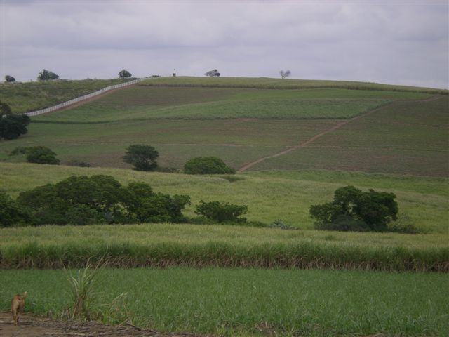
HERITAGE IMPACT ASSESSMENT OF INKWAZI ESTATE, BALLITO, KWAZULU-NATAL

                                                 Management summary

   eThembeni Cultural Heritage was appointed by Chapman Enterprises to undertake a heritage impact
   assessment of a proposed residential estate in Ballito, in terms of the KwaZulu-Natal Heritage Act No
   10 of 1997. Two eThembeni staff members inspected the area on 3 October 2008 and completed a
   controlled-exclusive surface survey, as well as a database and literature search.

   We identified no heritage resources within the proposed development area.

   The proposed development site is located close to the townlands of Ballito. The entire property is
   under sugar cane, with some drainage lines. Adjacent land uses consist of agricultural and residential
   properties. The site will be altered significantly and permanently by the proposed development, but it
   will be in keeping with the surrounding landscape.

   We recommend that the development proceed with no further heritage mitigation and have submitted
   this report to Amafa aKwaZulu-Natali in fulfilment of the requirements of the KwaZulu-Natal Heritage
   Act. The client may contact Ms Wesiwe Tshabalala at Amafa’s Pietermaritzburg office (telephone 033
   3946 543) in due course to enquire about the Council’s decision.

   If permission is granted for the development to proceed, the client is reminded that the Act requires
   that a developer cease all work immediately and notify Amafa aKwaZulu-Natali should any heritage
   resources, as defined in the Act, be discovered during the course of development activities.

eThembeni Cultural Heritage for Chapman Enterprises                                                Page 2
HERITAGE IMPACT ASSESSMENT OF INKWAZI ESTATE, BALLITO, KWAZULU-NATAL
TABLE OF CONTENTS
Page
Introduction and legislation 4
Nature of proposed activities 6
Site access, description and environmental issues 7
Methodology 8
Observations and recommendations 8
Summary of findings in terms of the KwaZulu-Natal Heritage Act 1997 Section 27(3) 10
Conclusion 10
Appendix A – A history of South Africa until 1902 11
Appendix B – Significance and value of heritage resources 26
Appendix C – Criteria for the identification and management of cultural landscapes 29
Appendix D – Statement of independence and ability 30
eThembeni Cultural Heritage for Chapman Enterprises Page 3HERITAGE IMPACT ASSESSMENT OF INKWAZI ESTATE, BALLITO, KWAZULU-NATAL
Introduction and legislation
eThembeni Cultural Heritage was appointed by Chapman Enterprises to undertake a heritage impact
assessment of a proposed residential estate in Ballito, in terms of the KwaZulu-Natal Heritage Act No 10 of
1997. Section 27(1) of the Act requires such an assessment in case of:
(a) construction of a road, wall, power line, pipeline, canal or other similar form of linear development
or barrier exceeding 300 m in length;
(b) construction of a bridge or similar structure exceeding 50 m in length; and
(c) any development, or other activity which will change the character of an area of land, or
water –
2
(i) exceeding 10 000 m in extent;
(ii) involving three or more existing erven or subdivisions thereof; or
(iii) involving three or more erven, or subdivisions thereof, which have been consolidated
within the past five years; or
(d) the costs of which will exceed a sum set in terms of regulations; or
(e) any other category of development provided for in regulations.
A heritage impact assessment is not limited to archaeological artefacts, historical buildings and graves. It is
far more encompassing and includes intangible and invisible resources such as places, oral traditions and
rituals. In the KwaZulu-Natal Heritage Act 1997 a heritage resource is defined any place or object of cultural
significance i.e. of aesthetic, architectural, historical, scientific, social, spiritual, linguistic or technological
value or significance. This includes the following wide range of places and objects:
(a) places, buildings, structures and equipment;
(b) places to which oral traditions are attached or which are associated with living heritage;
(c) historical settlements and townscapes;
(d) landscapes and natural features;
(e) geological sites of scientific or cultural importance;
(f) archaeological and palaeontological sites;
(g) graves and burial grounds, including -
(i) ancestral graves,
(ii) royal graves and graves of traditional leaders,
(iii) graves of victims of conflict,
(iv) graves of important individuals,
(v) historical graves and cemeteries older than 60 years, and
(vi) other human remains which are not covered under the Human Tissues Act, 1983 (Act No.65
of 1983 as amended);
(h) movable objects, including -
(i) objects recovered from the soil or waters of South Africa including archaeological and
palaeontological objects and material, meteorites and rare geological specimens;
(ii) ethnographic art and objects;
(iii) military objects;
(iv) objects of decorative art;
(v) objects of fine art;
(vi) objects of scientific or technological interest;
(vii) books, records, documents, photographic positives and negatives, graphic, film or video
material or sound recordings; and
(viii) any other prescribed categories,
but excluding any object made by a living person;
(i) battlefields;
(j) traditional building techniques.
eThembeni Cultural Heritage for Chapman Enterprises Page 4HERITAGE IMPACT ASSESSMENT OF INKWAZI ESTATE, BALLITO, KWAZULU-NATAL
A ‘place’ is defined as:
(a) a site, area or region;
(b) a building or other structure (which may include equipment, furniture, fittings and articles associated
with or connected with such building or other structure);
(c) a group of buildings or other structures (which may include equipment, furniture, fittings and articles
associated with or connected with such group of buildings or other structures); and
(d) an open space, including a public square, street or park; and in relation to the management of a place,
includes the immediate surroundings of a place.
‘Structures’ means any building, works, device, or other facility made by people and which is fixed to land and
any fixtures, fittings and equipment associated therewith older than 60 years.
‘Archaeological’ means -
(a) material remains resulting from human activity which are in a state of disuse and are in or on land and
are older than 100 years, including artefacts, human and hominid remains and artificial features and
structures;
(b) rock art, being a form of painting, engraving or other graphic representation on a fixed rock surface or
loose rock or stone, which was executed by human agency and is older than 100 years including any
area within 10 m of such representation; and
(c) wrecks, being any vessel or aircraft, or any part thereof, which was wrecked in South Africa, whether
on land or in the maritime cultural zone referred to in section 5 of the Maritime Zones Act 1994 (Act 15
of 1994), and any cargo, debris or artefacts found or associated therewith, which are older than 60
years or which in terms of national legislation are considered to be worthy of conservation;
(d) features, structures and artefacts associated with military history which are older than 75 years and
the sites on which they are found.
‘Palaeontological’ means any fossilised remains or fossil trace of animals or plants which lived in the
geological past, other than fossil fuels or fossiliferous rock intended for industrial use, and any site which
contains such fossilised remains or trace.
‘Grave’ means a place of interment and includes the contents, headstone or other marker of and any other
structures on or associated with such place. Amafa aKwaZulu-Natali will only issue a permit for the alteration
of a grave if it is satisfied that every reasonable effort has been made to contact and obtain permission from
the families concerned. Since Amafa has not yet formulated guidelines or regulations for the removal of
human remains, eThembeni adheres to the following procedures, compiled in discussion with the South
African Heritage Resources Agency and used by professional colleagues:
Notification of the impending removals (using English and Zulu language media and notices
at the grave site);
Consultation with individuals or communities related or known to the deceased;
Satisfactory arrangements for the curation of human remains and / or headstones in a
museum, where applicable;
Procurement of a permit from Amafa aKwaZulu-Natali;
Appropriate arrangements for the exhumation (preferably by a suitably trained archaeologist)
and re-interment (sometimes by a registered undertaker, in a formally proclaimed cemetery);
Observation of rituals or ceremonies required by the families.
eThembeni Cultural Heritage for Chapman Enterprises Page 5HERITAGE IMPACT ASSESSMENT OF INKWAZI ESTATE, BALLITO, KWAZULU-NATAL Nature of proposed activities (information obtained from the client) The proposal includes the development of 1800 residential units (Planned Unit Development of Medium Density) in clustered villages, as well as the possible development of a school, cultural village, hotel, limited commercial high street and activity zone adjacent to the main road. The proposed development covers an area of 59 hectares in Ballito, KwaZulu-Natal North Coast. Approximately 25 hectares is suitable for development, the remainder of the site has been identified as wetland and wetland buffer and consequently no development will occur in these areas. The individual villages will be separated by open spaces and conservation areas and emphasis will be on strong urban form, structure, landscaping and urban design criteria. Water will be supplied by the municipality and sewage will be via mains sewer to the new sewage treatment works on the uMhlali River. Alternative and sustainable energy options will be examined as part of the project design process. There will be up to two entrances to the development from Main Road 228. Access around the site will, where possible, follow existing cane tracks. A master home owners association (Property Owners Association) will be established and all individual home owners associations and / or body corporates shall belong to the master home owners association. The said home owners association(s) shall be responsible for the ongoing maintenance of certain services and infrastructure as per the rates policy and excluded services agreement with the KwaDukuza Municipality. A scoping study will be undertaken in accordance with the Regulations published in terms of the National Environmental Management Act – GNR 387, triggered by Schedule (2) ‘Any development activity, including associated structures and infrastructure , where the total area of the developed area is, or is intended to be, 20ha or more’. These Regulations are administered by the Department of Agriculture and Environmental Affairs – KwaZulu-Natal. The scoping study will be followed by an Environmental Impact Assessment. An Environmental Management Plan will be compiled which will address issues such as the recreational usage of the open space areas, the rehabilitation of wetlands etc. The study will involve consultation with all Interested and Affected Parties (neighbours, NGOs, local conservancies, authorities, public etc). The study will investigate planning issues and surrounding land use, the ecology of the area, social and economic considerations, as well as alternatives considered, matters raised by all interested and affected parties and the mitigation and management of any potential impacts. eThembeni Cultural Heritage for Chapman Enterprises Page 6
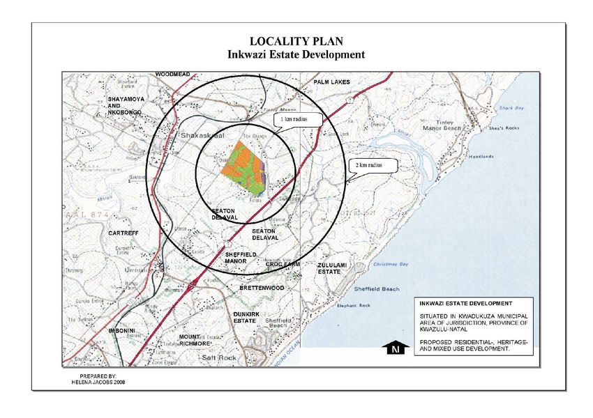
HERITAGE IMPACT ASSESSMENT OF INKWAZI ESTATE, BALLITO, KWAZULU-NATAL

Site access, description and environmental issues (information obtained from the client)

Road access to the proposed development site is from the N2 freeway northbound from Durban. Take exit
214 Umhlali / Salt Rock and turn right and then left towards Sheffield Beach. Follow the signage to Seaton
Delaval; the proposed development area is located between the Animal Farm and Seaton Delaval
properties (see following map).

The properties concerned are:

Rem of Portion 19 of Farm Lot 69 No. 917
Portion 13 of Farm Lot 69 No. 917
Portion 39 of Farm Lot 69 No. 917
Portion 15 of Farm Lot 69 No. 917
Rem of Portion 20 of Farm Lot 69 No. 917
Portion 150 of Farm Lot 69 No. 917
Portion 109 of Farm Lot 69 No. 917

The site comprises mainly sugar cane, with small amounts of indigenous vegetation in the drainage
channels.

eThembeni Cultural Heritage for Chapman Enterprises                                              Page 7
HERITAGE IMPACT ASSESSMENT OF INKWAZI ESTATE, BALLITO, KWAZULU-NATAL
Methodology
Two eThembeni staff members inspected the entire proposed development area on 3 October 2008. We
completed a controlled-exclusive surface survey, where ‘sufficient information exists on an area to make
solid and defensible assumptions and judgements about where [heritage resource] sites may and may not
be’ and ‘an inspection of the surface of the ground, wherever this surface is visible, is made, with no
substantial attempt to clear brush, turf, deadfall, leaves or other material that may cover the surface and with
no attempt to look beneath the surface beyond the inspection of rodent burrows, cut banks and other
1
exposures that are observed by accident’ (King 1978 ).
We consulted various provincial databases, including historical, archaeological and geological sources and
provide a concise summary of South Africa’s pre and post-colonial history, included as Appendix A. We
assessed the value and significance of heritage resources, as defined in the KwaZulu-Natal Heritage Act
1997 and the criteria contained in Appendix B. Culturally significant landscapes were assessed according to
the criteria in Appendix C.
The client has provided a map of the area, submitted to Amafa separately. Geographic coordinates were
obtained with a handheld Garmin GPS72 global positioning unit. Photographs were taken with a Nikon
Coolpix S200 digital camera and submitted to Amafa on compact disc. Appendix D contains a statement of
independence and a summary of our ability to undertake this heritage impact assessment.
The assumptions and limitations of this heritage impact assessment are as follows:
We have assumed that the description of the proposed project, provided by Chapman Enterprises, is
accurate.
We have assumed that the public consultation process undertaken as part of the Environmental
Impact Assessment is sufficient and adequate and does not require repetition as part of the heritage
impact assessment.
Soil surface visibility was good to non-existent. Heritage resources might be present below the
surface or in areas of dense vegetation and we remind the client that the Act requires that a
developer cease all work immediately and notify Amafa should any heritage resources, as defined in
the Act, be discovered during the course of development activities.
No subsurface investigation (including excavations or sampling) were undertaken, since a permit
from Amafa aKwaZulu-Natali is required to disturb a heritage resource.
Observations and recommendations
No development activities associated with the proposed project had begun at the time of our visit, in
accordance with provincial heritage legislation.
Places, buildings, structures and equipment
None were identified within the proposed development area.
Places to which oral traditions are attached or which are associated with living heritage
None were identified within the proposed development area.
Historical settlements and townscapes
None were identified within the proposed development area.
1
King, T. F. 1989. The archaeological survey: methods and uses. Quoted in Canter, L. W. 1996. Environmental impact assessment.
Second Edition. New York: McGraw-Hill, Inc.
eThembeni Cultural Heritage for Chapman Enterprises Page 8HERITAGE IMPACT ASSESSMENT OF INKWAZI ESTATE, BALLITO, KWAZULU-NATAL
Landscapes and natural features
The proposed development site is located close to the townlands of Ballito. The entire property is under
sugar cane, with some drainage lines. Adjacent land uses consist of agricultural and residential properties.
The site will be altered significantly and permanently by the proposed development, but it will be in keeping
with the surrounding landscape.
Geological sites of scientific or cultural importance
None were identified within the proposed development area.
Archaeological and palaeontological sites
None were identified within the proposed development area.
Graves and burial grounds
None were identified within the proposed development area.
Movable objects excluding any object made by a living person
None were identified within the proposed development area.
Battlefields
None were identified within the proposed development area.
Traditional building techniques
None were identified within the proposed development area.
eThembeni Cultural Heritage for Chapman Enterprises Page 9HERITAGE IMPACT ASSESSMENT OF INKWAZI ESTATE, BALLITO, KWAZULU-NATAL
Summary of findings in terms of the KwaZulu-Natal Heritage Act 1997 Section 27(3)
(a) the identification and mapping of all heritage resources in the area affected
None.
(b) an assessment of the significance of such resources in terms of the heritage assessment criteria set
out in regulations
Not applicable.
(c) an assessment of the impact of development on such heritage resources
Not applicable.
(d) an evaluation of the impact of the development on heritage resources relative to the sustainable social
and economic benefits to be derived from the development
Not applicable.
(e) the results of consultation with communities affected by the proposed development and other
interested parties regarding the impact of the development on heritage resources
The client has undertaken such consultation in terms of statutory requirements and retains the relevant
documentation.
(f) if heritage resources will be adversely affected by the proposed development, the consideration of
alternatives
Not applicable.
(g) plans for mitigation of any adverse effects during and after completion of the proposed development
If permission is granted for development to proceed, the client is reminded that the Act requires that a developer
cease all work immediately and notify Amafa should any heritage resources, as defined in the Act, be discovered
during the course of development activities.
Conclusion
We recommend that the development proceed with no further heritage mitigation and have submitted this report to
Amafa aKwaZulu-Natali in fulfilment of the requirements of the KwaZulu-Natal Heritage Act. According to Section
27(4) of the Act:
The report shall be considered timeously by the Council which shall, after consultation with the person
proposing the development, decide -
(a) whether or not the development may proceed;
(b) any limitations or conditions are to be applied to the development;
(c) what general protections in terms of this Act apply, and what formal protections may be
applied to such heritage resources;
(d) whether compensatory action shall be required in respect of any heritage resources damaged
or destroyed as a result of the development; and
(e) whether the appointment of specialists is required as a condition of approval of the proposal.
The client may contact Ms Wesiwe Tshabalala at Amafa’s Pietermaritzburg office (telephone 033 3946 543)
in due course to enquire about the Council’s decision.
eThembeni Cultural Heritage for Chapman Enterprises Page 10HERITAGE IMPACT ASSESSMENT OF INKWAZI ESTATE, BALLITO, KWAZULU-NATAL
APPENDIX A
A HISTORY OF SOUTH AFRICA UNTIL 1902
The following information was obtained from the website
http://www.britannica.com/EBchecked/topic/555568/South-Africa/44057/Pastoralism-and-early-
agriculture#tab=active~checked%2Citems~checked&title=South%20Africa%20%3A%3A%20Pastoralism%2
0and%20early%20agriculture%20--%20Britannica%20Online%20Encyclopedia
The authors of this document are Colin J. Bundy, Julian R. D. Cobbing, Martin Hall and Leonard Monteath
Thompson
The prehistory and history of South Africa span nearly the entire known existence of human beings and their
ancestors—some three million years or more—and include the wandering of small bands of hominins
through the savanna, the inception of herding and farming as ways of life, and the construction of large
urban centres. Through this diversity of human experience, several trends can be identified: technological
and economic change, shifting systems of belief, and, in the earlier phases of humanity, the interplay
between physical evolution and learned behaviour, or culture. Over much of this time frame, South Africa’s
past is also that of a far wider area, and only in the last few centuries has this southernmost country of Africa
had a history of its own. This article focuses on the country of South Africa.
The Stone Age
The earliest creatures that can be identified as ancestors of modern humans are classified as
australopithecines (literally “southern apes”). The first specimen of these hominins to be found (in 1924) was
the skull of a child from a quarry site at Taung in what is now the North-West province. Subsequently more
australopithecine fossils were discovered in limestone caves farther northeast at Sterkfontein, Swartkrans,
and Kromdraai (collectively designated a World Heritage site in 1999), where they had originally been
deposited by predators and scavengers.
South Africa’s prehistory has been divided into a series of phases based on broad patterns of technology.
The primary distinction is between a reliance on chipped and flaked stone implements (the Stone Age) and
the ability to work iron (the Iron Age). Spanning a large proportion of human history, the Stone Age in
Southern Africa is further divided into the Early Stone Age, or Paleolithic Period (about 2,500,000–150,000
years ago), the Middle Stone Age, or Mesolithic Period (about 150,000–30,000 years ago), and the Late
Stone Age, or Neolithic Period (about 30,000–2,000 years ago). The simple stone tools found with
australopithecine fossil bones fall into the earliest part of the Early Stone Age.
o The Early Stone Age
Most Early Stone Age sites in South Africa can probably be connected with the hominin species known as
Homo erectus. Simply modified stones, hand axes, scraping tools, and other bifacial artifacts had a wide
variety of purposes, including butchering animal carcasses, scraping hides, and digging for plant foods. Most
South African archaeological sites from this period are the remains of open camps, often by the sides of
rivers and lakes, although some are rock shelters, such as Montagu Cave in the Cape region.
Change occurred slowly in the Early Stone Age; for more than a million years and over a wide geographic
area, only slight differences existed in the forms of stone tools. The slow alterations in hominins’ physical
appearance that took place over the same time period, however, have allowed physical anthropologists to
recognize new species in the genus Homo. An archaic form of H. sapiens appeared about 500,000 years
ago; important specimens belonging to this physical type have been found at Hopefield in Western Cape
province and at the Cave of Hearths in Mpumalanga province.
o The Middle Stone Age
The long episode of cultural and physical evolution gave way to a period of more rapid change about
200,000 years ago. Hand axes and large bifacial stone tools were replaced by stone flakes and blades that
eThembeni Cultural Heritage for Chapman Enterprises Page 11HERITAGE IMPACT ASSESSMENT OF INKWAZI ESTATE, BALLITO, KWAZULU-NATAL
were fashioned into scrapers, spear points, and parts for hafted, composite implements. This technological
stage, now known as the Middle Stone Age, is represented by numerous sites in South Africa.
Open camps and rock overhangs were used for shelter. Day-to-day debris has survived to provide some
evidence of early ways of life, although plant foods have rarely been preserved. Middle Stone Age bands
hunted medium-sized and large prey, including antelope and zebra, although they tended to avoid the
largest and most dangerous animals, such as the elephant and the rhinoceros. They also ate seabirds and
marine mammals that could be found along the shore and sometimes collected tortoises and ostrich eggs in
large quantities. The rich archaeological deposits of Klasies River Mouth on the Cape coast west of Port
Elizabeth have preserved the first known instance of shellfish being used as a food source.
Klasies River Mouth has also provided important evidence for the emergence of anatomically modern
humans. Some of the human skeletons from the lower levels of this site, possibly 115,000 years old, are
decidedly modern in form. Fossils of comparable age have been excavated at Border Cave, in the
mountainous region between KwaZulu-Natal province and Swaziland.
o The Late Stone Age
Basic toolmaking techniques began to undergo additional change about 40,000 years ago. Small finely
worked stone implements known as microliths became more common, while the heavier scrapers and points
of the Middle Stone Age appeared less frequently. Archaeologists refer to this technological stage as the
Late Stone Age. The numerous collections of stone tools from South African archaeological sites show a
great degree of variation through time and across the subcontinent.
The remains of plant foods have been well preserved at such sites as Melkhoutboom Cave, De Hangen, and
Diepkloof in the Cape region. Animals were trapped and hunted with spears and arrows on which were
mounted well-crafted stone blades. Bands moved with the seasons as they followed game into higher lands
in the spring and early summer months, when plant foods could also be found. When available, rock
overhangs became shelters; otherwise, windbreaks were built. Shellfish, crayfish, seals, and seabirds were
also important sources of food, as were fish caught on lines, with spears, in traps, and possibly with nets.
Dating from this period are numerous engravings on rock surfaces, mostly on the interior plateau, and
paintings on the walls of rock shelters in the mountainous regions, such as the Drakensberg and Cederberg
ranges. The images were made over a period of at least 25,000 years. Although scholars originally saw the
South African rock art as the work of exotic foreigners such as Minoans or Phoenicians or as the product of
primitive minds, they now believe that the paintings were closely associated with the work of medicine men,
shamans who were involved in the well-being of the band and often worked in a state of trance. Specific
representations include depictions of trance dances, metaphors for trance such as death and flight,
rainmaking, and control of the movement of antelope herds.
o Pastoralism and early agriculture
New ways of living came to South Africa about 2,000 years ago. Until that time, human communities had
survived by gathering plant foods and by hunting, trapping, and scavenging for meat, but with the
introduction of agriculture—arguably the single most important event in world history—people began to make
use of domesticated animals and plants. This in turn led to a slow but steady rise in population and to more
complex political and religious organizations, among other things. Crops could be grown and cattle, sheep,
and goats herded near permanent villages and towns in the east, where rainfall was adequate. In the more
arid west, domestic livestock were kept by nomadic pastoralists, who moved over wide territories with their
flocks and herds.
Although the origin of nomadic pastoralism in South Africa is still obscure, linguistic evidence points to
northern Botswana as a probable source. The linguistic evidence is supported by finds of sheep bones and
pottery from Bambata Cave in southwestern Zimbabwe that have been dated to about 150 BCE. Whether
new communities moved into South Africa with their flocks and herds or whether established hunter-gatherer
bands took up completely new ways of living remains unclear. In any case, the results of archaeological
excavations have shown that sheep were being herded fairly extensively by the first few centuries ACE in
eastern and western parts of the Cape and probably in the northern Cape as well.
While traces of ancient herding camps tend to be extremely rare, one of the best-preserved finds is at
Kasteelberg, on the southwest coast near St. Helena Bay. Pastoralists there kept sheep, hunted seals and
eThembeni Cultural Heritage for Chapman Enterprises Page 12HERITAGE IMPACT ASSESSMENT OF INKWAZI ESTATE, BALLITO, KWAZULU-NATAL
other wild animals, and gathered shellfish, repeatedly returning to the same site for some 1,500 years. Such
communities were directly ancestral to the Khoekhoe (also spelled Khoikhoi) herders who encountered
European settlers at the Cape of Good Hope in the mid-17th century.
The archaeological traces of farmers in the eastern regions of South Africa are more substantial. The earliest
sites date to the 3rd century ACE, although farming was probably already well established by this time.
Scatters of potsherds with distinctive incised decoration mark early village locations in Mpumalanga and
parts of KwaZulu-Natal.
The Iron Age
Because the first farmers had knowledge of ironworking, their archaeological sites are characterized as Iron
Age (c. ACE 200). New groups of people arriving in South Africa at that time had strong connections to East
Africa. They were directly ancestral to the Bantu-speaking peoples who form the majority of South Africa’s
population today.
o Iron Age sites
Early Iron Age farmers grew crops, cutting back the vegetation with iron hoes and axes, and herded cattle
and sheep. They heavily supplemented farming by gathering wild plant foods, engaging in some hunting,
and collecting shellfish if they lived near enough to the coast. Where conditions for agriculture were
favourable, such as in the uThukela River valley in the east, villages grew to house several hundred people.
Some trade existed between groups of farmers—evidence for specialization in salt making has been found in
the northeast—and with the hunter-gatherer bands that continued to occupy most parts of South Africa.
Finely made life-size ceramic heads found near the city of Lydenburg (now Mashishing) in eastern South
Africa and dated to the 7th century ACE are all that remains of the people who once inhabited this region.
Early Iron Age villages were built in low-lying areas, such as river valleys and the coastal plain, where forests
and savannas facilitated shifting (slash-and-burn) agriculture. From the 11th century, however, in the period
conventionally known as the Late Iron Age, farming communities began to settle the higher-lying grasslands.
It has not been established whether these new communities were inhabited by invaders or reflected the
diffusion of new knowledge to existing populations. In many areas the new communities started making
different forms of pottery and built villages out of stone. Most probably these and other changes in patterns
of behaviour reflect the increasing importance of cattle in economic life.
o First urban centres
Other changes came in the north. Arab traders established small settlements on the Tanzanian and
Mozambican coasts in their search for ivory, animal skins, and other exotica. The trade beads they offered in
return began to reach villages in the interior, the first indications that the more complex economic and social
structures associated with long-distance trade were developing. The arid Limpopo River valley, avoided by
the earliest farmers, developed as a trade route. Sites such as Pont Drift (c. 800–1100) and Schroda (dated
to the 9th century) show that their occupants were wealthy in both livestock and trade beads.
The Limpopo River valley was also the setting in which Bambandyanalo and Mapungubwe developed as
South Africa’s first urban centres during the 11th century. Starting as a large village like Schroda and Pont
Drift, Mapungubwe rapidly developed into a town of approximately 10,000 people. Differences in status were
clearly demarcated: the elite lived and were buried at the top of the stark sandstone hill at the town’s centre,
while the rest of the population lived in the valley below. Hilltop graves contained lavish burial goods,
including a carefully crafted gold rhinoceros and evidence of specialized crafts such as bone and ivory
working. Bambandyanalo and Mapungubwe were abandoned after the 13th century after having been
occupied for several hundred years. The trade connections that the Limpopo valley offered were taken over
by Great Zimbabwe, farther to the north.
o Europeans in South Africa
The first Portuguese ships rounded the Cape of Good Hope in 1488, their occupants intent on gaining a
share of the lucrative Arab trade with the East. Over the following century, numerous vessels made their way
around the South African coast, but the only direct African contacts came with the bands of shipwreck
survivors who either set up camp in the hope of rescue or tried to make their way northward to Portuguese
settlements in present-day Mozambique. Both the British and the Dutch challenged the Portuguese control of
the Cape sea route from the early 17th century. The British founded a short-lived settlement at Table Bay in
eThembeni Cultural Heritage for Chapman Enterprises Page 13HERITAGE IMPACT ASSESSMENT OF INKWAZI ESTATE, BALLITO, KWAZULU-NATAL 1620, and in 1652 the Dutch East India Company set up a small garrison under the slopes of Table Mountain for provisioning their fleets. Settlement of the Cape Colony The Dutch East India Company, always mindful of unnecessary expense, did not intend to establish more than a minimal presence at the southernmost part of Africa. Because farming beyond the shores of Table Bay proved necessary, however, nine men were released from their contracts with the company and granted land along the Liesbeek River in 1657. The company made it clear that the Khoekhoe were not to be enslaved, so, beginning in that same year, slaves arrived in the Cape from West and East Africa, India, and the Malay Peninsula. By the end of the century, the imprint of Dutch colonialism in South Africa was clear, with settlers, aided by increasing numbers of slaves, growing wheat, tending vineyards, and grazing their sheep and cattle from the Cape peninsula to the Hottentots Holland Mountains some 30 miles (50 km) away. A 1707 census of the Dutch at the Cape listed 1,779 settlers owning 1,107 slaves. In the initial years of Dutch settlement at the Cape, pastoralists had readily traded with the Dutch. However, as the garrison’s demand for cattle and sheep continued to increase, the Khoekhoe became more wary. The Dutch offered tobacco, alcohol, and trinkets for livestock. Numerous conflicts followed, and, beginning in 1713, many Khoekhoe communities were ravaged by smallpox. At the same time, colonial pastoralists—the Boers, also called trekboers—began to move inland beyond the Hottentots Holland Mountains with their own herds. The Khoekhoe chiefdoms were largely decimated by the end of the 18th century, their people either dead or reduced to conditions close to serfdom on colonial farms. The San—small bands of hunter- gatherers—fared no better. Pushed back into marginal areas, they were forced to live by cattle raiding, justifying in colonial eyes their systematic eradication. The men were slaughtered, and the women and children were taken into servitude. The trekboers constantly sought new land, and they and their families spread northeast as well as north, into the grasslands that long had been occupied by African farmers. For many generations these farmers had lived in settlements concentrated along the low ridges that break the monotony of the interior plateau. While it is difficult to make population estimates, it is thought that some of the larger villages could have housed several hundred people. Cattle were held in elaborately built stone enclosures, the ruins of which survive today across a large part of Free State province and in the higher areas north of the Vaal River. Extensive exchange networks brought iron for hoes and spears from specialized manufacturing centres in the Mpumalanga Lowveld and the deep river gorges of KwaZulu-Natal. Thus, by the closing decades of the 18th century, South Africa had fallen into two broad regions: west and east. Colonial settlement dominated the west, including the winter rainfall region around the Cape of Good Hope, the coastal hinterland northward toward the present-day border with Namibia, and the dry lands of the interior. Trekboers took increasingly more land from the Khoekhoe and from remnant hunter-gatherer communities, who were killed, were forced into marginal areas, or became labourers tied to the farms of their new overlords. Indigenous farmers controlled both the coastal and valley lowlands and the Highveld of the interior in the east, where summer rainfall and good grazing made mixed farming economies possible. Cape Town was developing into South Africa’s major urban centre, although it took many years for it to equal the size that Mapungubwe had attained some five centuries earlier. The initial grid of streets had been expanded and linked the company’s garden to the new fortress that overlooked Table Bay. Houses featuring flat roofs, ornate pediments, and symmetrical facades sheltered officials, merchants, and visitors en route between Europe and the East. A governor and council administered the town and colony. While the economy was in principle directed by the interests of the Dutch East India Company, in practice corruption and illegal trading were dominant forces. Both the town and the colony existed in large part because of slaves, who by now outnumbered their owners. eThembeni Cultural Heritage for Chapman Enterprises Page 14
HERITAGE IMPACT ASSESSMENT OF INKWAZI ESTATE, BALLITO, KWAZULU-NATAL

Growth of the colonial economy

From 1770 to 1870 the region became more fully integrated into the world capitalist economy. Trekboers,
who were weakly controlled by the Dutch East India Company, advanced across the semidesert Karoo of the
central Cape and collided with African agricultural peoples along a line running from the lower Vaal and
middle Orange river valleys to the sea around the Gamtoos River (west of modern Port Elizabeth). These
agriculture-based African societies proved resilient but, even at their height in the 1860s, were unable to
unite completely enough to expel the Europeans.

The decisive moment for the colony occurred in 1806 when Britain seized Cape Colony during the
Napoleonic Wars. Initially the colony’s importance was related to its function as a strategic base to protect
Britain’s developing empire in India. In the next few years, however, it also served as a market, a source of
raw materials, and an outlet for emigration from Britain.

African societies after the 1760s were increasingly affected by ivory and slave traders operating from
Delagoa Bay, Inhambane, and the lower Zambezi River in the northeast as well as by traders and raiders
based in the Cape to the south. In response to these invasions, the farming communities created a number
of sister states different in structure, scale, and military capacity from anything that had existed before. The
Pedi and Swazi in the eastern Highveld, the Zulu south of the Pongola River, the Sotho to the east of the
Caledon River valley, the Gaza along the lower Limpopo, and the Ndebele in present-day southwestern
Zimbabwe proved to be the most successful.

The areas of the western Cape with the longest history of settlement by Europeans had evolved an
agricultural economy based on wheat farming and viticulture, worked by imported slave labour. Slaves were
treated harshly, and punishments for slaves who assaulted Europeans were brutal—one of the most heinous
being death by impalement. Escaped slaves formed groups called Maroons—small self-sufficient
communities—or fled into the interior. Because slave birth rates were low and settler numbers were
increasing, in the 1780s the Dutch stepped up the enserfment of surviving Khoe (also spelled Khoi;
pejoratively called Hottentots) to help run their farms. Those Khoe who could escape Dutch subjugation
joined Xhosa groups in a major counteroffensive against colonialism in 1799–1801, and there were slave
rebellions in the outskirts of Cape Town in 1808 and 1825.

The Dutch refusal to grant citizenship and land rights to the “Coloured” offspring of unions between
Europeans and Khoe or slaves produced an aggrieved class of people, known as Basters (or Bastards), who
were Christian, spoke Dutch, and had an excellent knowledge of horses and firearms. Many fled north
toward and over the Orange River in search of land and trading opportunities. After merging with
independent Khoe groups, such as the Kora, they formed commando states under warlords, three of the
more successful being the Bloem, Kok, and Barends families, who were persuaded by missionaries in the
early 19th century to change their name to Griqua. By the 1790s they were trading with and raiding local
African communities such as the Rolong, Tlhaping, Hurutshe, and Ngwaketse. For self-defense some of
these African communities formed larger groupings that competed against each other in their quest to control
trade routes going south to the Cape and east to present-day Mozambique.

The Portuguese and also some British, French, Americans, and Arabs traded beads, brass, cloth, alcohol,
and firearms along the southeast coast in return for ivory, slaves, cattle, gold, wax, and skins. During the late
18th century, large volumes of ivory were exported annually from Delagoa Bay, and slaves were taken from
the Komati and Usutu (a major tributary of the Maputo) river regions and sent to the Mascarene Islands in
the Indian Ocean and to Brazil to work on sugarcane and coffee plantations. By 1800 trade routes linked
Delagoa Bay and coastal trade routes with the central interior.

European trade precipitated structural transformation within societies inland of Delagoa Bay. Warlords
reorganized military institutions to hunt elephants and slaves. Profits from this trade enhanced the warlords’
ability to disperse patronage, attract followers, and raise military potential and, in turn, their capacity to
dominate land, people, and cattle. Near the bay, Tembe and Maputo were already powerful states by the
1790s. To the west of the coastal lowlands emerged the Maroteng of Thulare, the Dlamini of Ndvungunye,
and the Hlubi of Bhungane. Between the Pongola and Tugela rivers evolved the Mthethwa of Dingiswayo
south of Lake St. Lucia, the Ndwandwe of Zwide, the Qwabe of Phakatwayo, the Chunu of Macingwane,
and, south of the Tugela, the Cele and Thuli. Several groups—for example, the Mthethwa, Ndwandwe, and

eThembeni Cultural Heritage for Chapman Enterprises                                                   Page 15
HERITAGE IMPACT ASSESSMENT OF INKWAZI ESTATE, BALLITO, KWAZULU-NATAL

Qwabe—later merged with the Zulu. These groups competed to dominate trade and became more
militarized the closer they were to the Portuguese base.

The Cape Colony had spawned the subcolonies of Natal, the Orange Free State, and the Transvaal by the
1860s. European settlement advanced to the edges of the Kalahari region in the west, the Drakensberg and
Natal coast in the east, and the tsetse-fly- and mosquito-ridden Lowveld along the Limpopo River valley in
the northeast. Armed clashes erupted over land and cattle, such as those between the Boers and various
Xhosa groups in the southeast beginning in the 1780s, and Africans lost most of their land and were
henceforth forced to work for the settlers. The population of European settlers increased from some 20,000
in the 1780s to about 300,000 in the late 1860s. Although it is difficult to accurately estimate the African
population, it probably numbered somewhere between two and four million.

Increased European presence (c. 1810-35)

     o British occupation of the Cape
When Great Britain went to war with France in 1793, both countries tried to capture the Cape so as to control
the important sea route to the East. The British occupied the Cape in 1795, ending the Dutch East India
Company’s role in the region. Although the British relinquished the colony to the Dutch in the Treaty of
Amiens (1802), they reannexed it in 1806 after the start of the Napoleonic Wars. The Cape became a vital
base for Britain prior to the opening of the Suez Canal in 1869, and the Cape’s economy was meshed with
that of Britain. To protect the developing economy there, Cape wines were given preferential access to the
British market until the mid-1820s. Merino sheep were introduced, and intensive sheep farming was initiated
in order to supply wool to British textile mills.

The infrastructure of the colony began to change: English replaced Dutch as the language of administration;
the British pound sterling replaced the Dutch rix-dollar; and newspaper publishing began in Cape Town in
1824. After Britain began appointing colonial governors, an advisory council for the governor was established
in 1825, which was upgraded to a legislative council in 1834 with a few “unofficial” settler representatives. A
virtual freehold system of landownership gradually replaced the existing Dutch tenant system, under which
European colonists had paid a small annual fee to the government but had not acquired land ownership.

A large group of British settlers arrived in 1820; this, together with a high European birth rate and wasteful
land usage, produced an acute land shortage, which was alleviated only when the British acquired more land
through massive military intervention against Africans on the eastern frontier. Until the 1840s the British
vision of the colony did not include African citizens (referred to pejoratively by the British as “Kaffirs”), so, as
Africans lost their land, they were expelled across the Great Fish River, the unilaterally proclaimed eastern
border of the colony.

The first step in this process included attacks in 1811–12 by the British army on the Xhosa groups, the
Gqunukhwebe and Ndlambe. An attack by the Rharhabe-Xhosa on Graham’s Town (Grahamstown) in 1819
provided the pretext for the annexation of more African territory, to the Keiskamma River. Various Rharhabe-
Xhosa groups were driven from their lands throughout the early 1830s. They counterattacked in December
1834, and Governor Benjamin D’Urban ordered a major invasion the following year, during which thousands
of Rharhabe-Xhosa died. The British crossed the Great Kei River and ravaged territory of the Gcaleka-Xhosa
as well; the Gcaleka chief, Hintsa, invited to hold discussions with British military officials, was held hostage
and died trying to escape. The British colonial secretary, Lord Glenelg, who disapproved of D’Urban’s policy,
halted the seizure of all African land east of the Great Kei. D’Urban’s initial attempt to rule conquered
Africans with European magistrates and soldiers was overturned by Glenelg; instead, for a time, Africans
east of the Keiskamma retained their autonomy and dealt with the colony through diplomatic agents.

The British had chronic difficulties procuring enough labour to build towns and develop new farms. Indeed,
though Britain abolished its slave trade in 1807 and pressured other countries to do the same, the British in
Southern Africa continued to import some slaves into the Cape after that date, but in numbers insufficient to
alleviate the labour problem. A ban in 1809 on Africans crossing into the Cape aggravated the labour
shortage, and so the British, like the Dutch before them, made the Khoe serfs through the Caledon (1809)
and Cradock (1812) codes.

Anglo-Boer commandos provided another source of African labour by illegally capturing San women and
children (many of the men were killed) as well as Africans from across the eastern frontier. Griqua raiding

eThembeni Cultural Heritage for Chapman Enterprises                                                     Page 16
HERITAGE IMPACT ASSESSMENT OF INKWAZI ESTATE, BALLITO, KWAZULU-NATAL
states led by Andries Waterboer, Adam Kok, and Barend Barends captured more Africans from among
people such as the Hurutshe, Rolong, and Kwena. Other people, such as those known as the Mantatees,
were forced to become farmworkers, mainly in the eastern Cape. European farmers also raided for labour
north of the Orange River.
Cape authorities overhauled their policy in 1828 in order to facilitate labour distribution and to align the
region with the growing imperial antislavery ethos. Ordinance 49 permitted black labourers from east of the
Keiskamma to go into the colony for work if they possessed the proper contracts and passes, which were
issued by soldiers and missionaries. This was the beginning of the pass laws that would become so
notorious in the 20th century. Ordinance 50 briefly ended the restrictions placed on the Khoe, including
removing the requirement for passes, and allowed them to choose their employers, own land, and move
more freely. Because an insufficient labour force still existed, Anglo-Boer armies (supported by Khoe,
Tembu, Gcaleka, and Mpondo auxiliaries) acquired their own workers by attacking the Ngwane east of the
Great Kei at Mbolompo in August 1828. The formal abolition of slavery took place in 1834–38, and control of
African labourers became stricter through the Masters and Servants Ordinance (1841), which imposed
criminal penalties for breach of contract and desertion of the workplace and increased the legal powers of
settler employers.
o The Delagoa Bay slave trade
While events were unfolding at the Cape, the slave trade at Delagoa Bay had been expanding since about
1810 in response to demands for labour from plantations in Brazil and on the Mascarene Islands. During the
late 1820s, slave exports from the Delagoa Bay area reached several thousand a year, in advance of what
proved to be an ineffective attempt to abolish the Brazilian trade in 1830. After a dip in the early 1830s, the
Bay slave trade peaked in the late 1840s.
The impact of the slave trade was increasing destabilization of hinterland societies as populations were
forcibly removed. The Gaza, Ngoni, and other groups became surrogate slavers and joined the Portuguese
soldiers in inland raiding. Along the Limpopo and Vaal river networks, Delagoa Bay slavers competed with
Griqua slavers in supplying the Cape. After slavers burned crops and famines became common, many
groups—including the Ngwane, Ndebele, and some Hlubi—fled westward into the Highveld mountains
during the 1810s and ’20s. The Kololo, on the other hand, moved east out of Transorangia, where they ran
into Bay slavers, and migrated west into Botswana. In 1826 they were attacked by an alliance of Ngwaketse
and European mercenaries and ended up in Zambia in the 1850s exporting slaves themselves to the Arabs
and Portuguese.
o Emergence of the eastern states
Four main defensive African state clusters had emerged in eastern South Africa by the 1820s: the Pedi (led
by Sekwati) in the Steelpoort valley, the Ngwane (led by Sobhuza) in the eastern Transvaal, the Mokoteli
(led by Moshoeshoe) in the Caledon River region, and the Zulu (led by Shaka) south of the Swart-Mfolozi
River. The Pedi received refugees from the Limpopo and coastal plains, and the Mokoteli absorbed eastern
Transorangian refugees, which enabled them to defeat the Griqua and Korana raiders by the mid-1830s. By
1825 Shaka had welded the Chunu, Mthethwa, Qwabe, Mkhize, Cele, and other groups into a large
militarized state with fortified settlements called amakhanda. Zulu amabutho (age sets or regiments)
defended against raiders, provided protection for refugees, and, apparently, began to trade in ivory and
slaves themselves.
From 1824 the Zulu began to clash with Cape colonists who came to Port Natal (renamed Durban in 1835)
and organized mercenary armies. These groups were comparable to the Portuguese prazero armies along
the Zambezi and to the warlord state set up by the Portuguese trader João Albasini in the eastern Transvaal
in the 1840s, but they operated on a smaller scale. During the 1820s European raiders joined Zulu amabutho
in attacking areas north of the Swart-Mfolozi River and south of the Mzimkulu River, where in the mid-1820s
French ships exported slaves. Francis Farewell’s raiders, in alliance with Zulu groups, seized women and
children in the same area in 1828.
Conflicts split the Zulu elite into rival factions and led to Shaka’s assassination in 1828. Shaka’s half brother
Dingane became the Zulu leader, but his succession was accompanied by civil wars and by increasing
interference in the Delagoa Bay trading alliances. By the mid-1830s a coalition of Cape merchants had
begun planning for the formal colonization of Natal, with its superb agricultural soils and temperate climate.
eThembeni Cultural Heritage for Chapman Enterprises Page 17HERITAGE IMPACT ASSESSMENT OF INKWAZI ESTATE, BALLITO, KWAZULU-NATAL
The British left the less-desirable malaria-ridden Delagoa Bay region to the Portuguese, who traded slaves
out of Lourenço Marques (now Maputo, Mozam.) for another half century.
The expansion of European colonialism (c. 1835–70)
o The Great Trek
A few Boer settlers had moved north of the Orange River before 1834, but after that the number increased
significantly, a migration later known as the Great Trek. The common view that this was a bid to escape the
policies of the British—i.e., the freeing of slaves—is difficult to sustain, as most of the former slave owners
did not migrate (most trekkers came from the poorer east Cape), and the earlier labour shortage had been
alleviated by 1835. Instead, the trek was more of an explosive culmination of a long sequence of colonial
labour raids, land seizures, punitive commando raids, and commercial expansions. Europeans, who
possessed technologically advanced weaponry, also had instructive examples of how small groups of raiders
in Natal and Transorangia could cause disruption over large areas. Thus, the trekkers should not be seen as
backward feudalists escaping the modern world, as some historians have maintained, but as energized
people extending their frontier.
Several thousand Boers migrated with their families, livestock, retainers, wagons, and firearms into a region
already destabilized and partially depopulated by Griqua and coastal raiders. They did encounter some
Africans (such as the Ndebele), who in the early 1830s had moved from the southeastern to the western
Transvaal. The Boers and their Rolong, Taung, and Griqua allies, however, crushed the Ndebele during
1837, taking their land and many cattle, women, and children. The remaining Ndebele fled north, where they
resettled in southern Zimbabwe.
The trekkers had penetrated much of the Transvaal by the early 1840s. A grouping of commando states
emerged based at Potchefstroom, Pretoria, and, from 1845, Ohrigstad-Lydenburg in the eastern Transvaal.
Andries Hendrik Potgieter, Andries Pretorius, Jan Mocke, and others competed for followers, attacked
weaker African chiefdoms, hunted elephants and slaves, and forged trading links with the Portuguese. Other
Boers turned east into Natal and allied themselves with the resident British settlers. Farms developed slowly
and, as had been the case in the Cape prior to the 1830s, depended on forced labour. Until the 1860s the
Pedi and Swazi in the east and even the Kwena and Hurutshe in the west were strong enough to avoid being
conscripted as labour and thus limited the labour supply.
o The British in Natal
The appearance of thousands of British settlers in Natal in the 1840s and ’50s meant that for the first time
Africans and European settlers lived together—however uneasily—on the same land. The Boers began to
carve out farms in Natal as they had done along the eastern frontier, but further slave and cattle raids on the
Bhaca south of the Mzimkulu provided the pretext for British annexation of Natal in 1843. Theophilus
Shepstone received an appointment in 1845 as a diplomatic agent (later secretary for native affairs), and his
position served as a prototype for later native commissioners. The Harding Commission (1852) set aside
reserves for Africans, and missionaries and pliant chiefs were brought in to persuade Africans to work. After
1849 Africans became subject to a hut tax intended to raise revenue and drive them into labour. Roads were
built, using forced labour, and Africans were obliged to pay rent on state land and European farms. To meet
these burdens some African cultivators grew surplus crops to sell to the growing towns of Pietermaritzburg
and Durban.
The British were reluctant, though, to annex the Transorangian interior, where no strategic interests existed.
Boer trade links with Delagoa Bay posed little threat because Portugal was virtually a client state of Britain.
To the Boers fell the tasks of eroding African resistance and developing the land, although the policy never
received clear enunciation or much financial backing. Britain halfheartedly attempted to protect some of its
African client states, such asthat of the Griqua and the Sotho state led by Moshoeshoe. However, after
further fighting with the Rharhabe-Xhosa on the eastern frontier in 1846, Governor Colonel Harry Smith
finally annexed, over the next two years, not only the region between the Great Fish and the Great Kei rivers
(establishing British Kaffraria) but also a large area between the Orange and Vaal rivers, thus establishing
the Orange River Sovereignty. These moves provoked further warfare in 1851–53 with the Xhosa (joined
once more by many Khoe), with a few British politicians ineffectively trying to influence events.
A striking feature of this period was the capacity of the Sotho people to fend off military conquest by the
British and Boers. After defeating and absorbing the rival Tlokwa in 1853–54, Moshoeshoe became the most
eThembeni Cultural Heritage for Chapman Enterprises Page 18You can also read