Land at Pool House Road, Wombourne - Masterplan and Phasing Report - South Staffordshire Council
←
→
Page content transcription
If your browser does not render page correctly, please read the page content below
Land at Pool House
Road, Wombourne
Masterplan and Phasing Report
Masterplan and Phasing Report
Land at Pool House Road, Wombourne

    Executive Summary
    As part of the South Staffordshire District Council Local Plan review Apt Group are
    representing clients promoting ‘Land to the North of Pool House Road’ Wombourne. The site
    presents an excellent opportunity to grow the village in a sustainable and balanced manner
    whilst addressing both a large brownfield site which is available for development and
    building on the potential of land already safeguarded in that area.
    This document builds on the original site submission as part of the ‘Call for Sites’ which was
    undertaken in late 2018. The masterplan for the site clearly demonstrates that the site works
    much better as a whole rather than its constituent parts and represents a once in a lifetime
    opportunity to strategically plan for sustainable development. Planning strategically for
    housing growth will help meet the future needs of South Staffordshire.
    The site can be broken down into 3 distinct phases two of which are brownfield parcels of
    land and the other ‘greenfield’ site consists of a former landfill site. Linking the 3 sites
    together provides for a greater critical mass helping to secure a range of onsite and offsite
    infrastructure benefits that meet the objective of the Council’s Local Plan Review without
    overloading the area with an unsustainable level of development.
    To support the demonstration of the deliverability of the site, in advance of the ‘Strategic
    Spatial Strategy & Infrastructure’ consultation in Autumn 2019, investigations into key areas
    including highways, drainage, geotechnical (ground conditions) and ecology related to the
    site have been undertaken and inform the content of this document. There are no overriding
    physical, environmental or technical constraints affecting site delivery. The site is suitable,
    available and achievable for development during the lifetime of the new plan period.
    As the site progresses through the allocations process further work will be undertaken to
    support the adoption of this site in the final iteration of the Local Plan review.
    This document establishes a vision for sustainable growth in Wombourne and sets out the
    suitability, availability and achievability of development at this location which is summarised
    as:
    Suitable – the site would contribute to overall housing needs by providing a mix of housing
    types, tenures and sizes at a scale proportionate with the role and function of Wombourne.
    Together with bringing forward the adjacent safeguarded land, the proposal would rebalance
    the distribution of development across Wombourne; a comprehensive masterplan-led
    development would bring forward housing, infrastructure and open space.
    Available – the landowner(s) are willing sellers and have indicated support for release of the
    whole site from the West Midland Green Belt; there are no known legal or ownership issues
    that preclude the whole site’s development during the Local Plan period; neither are there
    any significant overriding physical or technical constraints preventing future delivery.
    Achievable – the whole site could be comprehensively developed with a quantum of
    development that would deliver benefits by retaining and enhancing green infrastructure,
    together with site remediation and socio-economic benefits in terms of housing provision and
    infrastructure contributions.

    2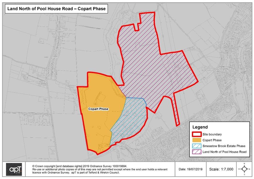
Masterplan and Phasing Report
Land at Pool House Road, Wombourne
Contents
1. Introduction
2. Site Location
3. Site Constraints
4. Site Description
5. Proximity to Local Services
6. Housing Requirement and Site Yield
7. Vision and Masterplan
8. Site Phasing
9. Onsite Infrastructure
10. Highways
11. Drainage
12. Geotechnical
13. Ecology
14. Alternative Sites
15. Performance Against Green Belt Objectives
16. Conclusions
17. Emerging Spatial Housing Strategy & Infrastructure Delivery Consultation
18. Annexes
Annex A. Drainage Note
Annex B. Geotechnical Note
Annex C. Ecology Note
Annex D. Site Masterplan
Annex E. Performance Against Green Belt Objectives
3
Masterplan and Phasing Report
Land at Pool House Road, Wombourne

    1. Introduction

    1.1.    South Staffordshire Council is reviewing its local plan. The review will consider the
            strategy and policies in both the core strategy and site allocations documents,
            updating evidence where necessary and setting out how much development is
            required in the district up until 2037. As part of this review new and/or amended
            policies will be proposed along with new residential and employment site allocations.

    1.2.    The Council’s Local Development Scheme (April 2019) sets out a broad timetable
            for key stages in preparing the local plan. The stages and dates are summarised in
            the following table.
     Table 1. Timetable for Local Plan Review
     Stage                                                  Dates
     Issues and options consultation                        October – November 2018.
                                                            Complete
     Strategic spatial strategy & infrastructure delivery   Autumn 2019
     consultation
     Preferred spatial strategy and sites                   Spring 2020
     Publication plan                                       Winter 2020-21
     Submission of local plan                               Autumn 2021
     Local plan examination                                 Winter 2021-22
     Local plan adoption                                    Summer 2022

    1.3.    The Council consulted on issues and options for the local plan review in October
            2018. This was the first stage of the local plan review and identified planning issues
            facing South Staffordshire. The document also set out a range of options for future
            development. Five housing growth options were proposed and they ranged from
            5,130 dwellings (270 per annum) to 25,130 dwellings (1,323 per annum) for the plan
            period 2018-37.

    1.4.    South Staffordshire Council consider that a minimum 9,130 dwellings (481 per
            annum) would be a proportionate contribution towards its own housing needs and
            also providing an element of unmet need from the wider Greater Birmingham
            Housing Market Area. This option is one of many and a decision has not been made
            on a preferred level of growth. Should the Greater Birmingham housing shortfall be
            reduced, the contribution from South Staffordshire to the housing market area
            shortfall would also be proportionally reduced.

    1.5.    Six spatial options for distributing housing growth are presented in the issues and
            options consultation. They comprise various combinations of housing growth
            including urban extensions, village growth, intensification of development within
            existing village boundaries and new settlements. The options are not mutually
            exclusive and a combination of options could be the most sustainable solution.

    4
Masterplan and Phasing Report
Land at Pool House Road, Wombourne
1.6. Consultation responses from the issues and options stage are available on the
Council’s website. A summary of responses will be published later in the year. The
Council has not made any decisions on which growth option, or combination of
options, to take forward in the local plan review.
1.7. The next stage in the local plan review is to consult on the overall strategy and
broad locations for future development, including infrastructure delivery
requirements. Consultation on the strategic spatial strategy and infrastructure
delivery is scheduled for autumn 2019. Consultation on the preferred strategy for
development will follow in spring 2020.
1.8. Given the identified need for housing growth, the Council launched a call for sites
exercise to identify land which could be developed for housing and economic uses.
Portions of the land north of Pool House Road were submitted for consideration in
2018 (site references 310, 311 and 458). A Strategic Housing and Economic Land
Availability Assessment (SHELAA) was published later in 2018 and sets out a broad
assessment of each site’s suitability, availability and achievability, in accordance
with the National Planning Policy Framework (NPPF). The submitted portions of the
Pool House Road site were considered potentially suitable but subject to policy
constraints at present, namely the Green Belt designation.
1.9. This document expands on the previous call for sites submission and summarises
the land north of Pool House Road’s suitability, availability and achievability for
future development.
1.10. A summary of the emerging Spatial Housing Strategy & Infrastructure Delivery
consultation is included in section 17 of this document. The proposed consultation
documents have been made available on the Council’s website prior to review by
Scrutiny Committee on the 10 October 2019.
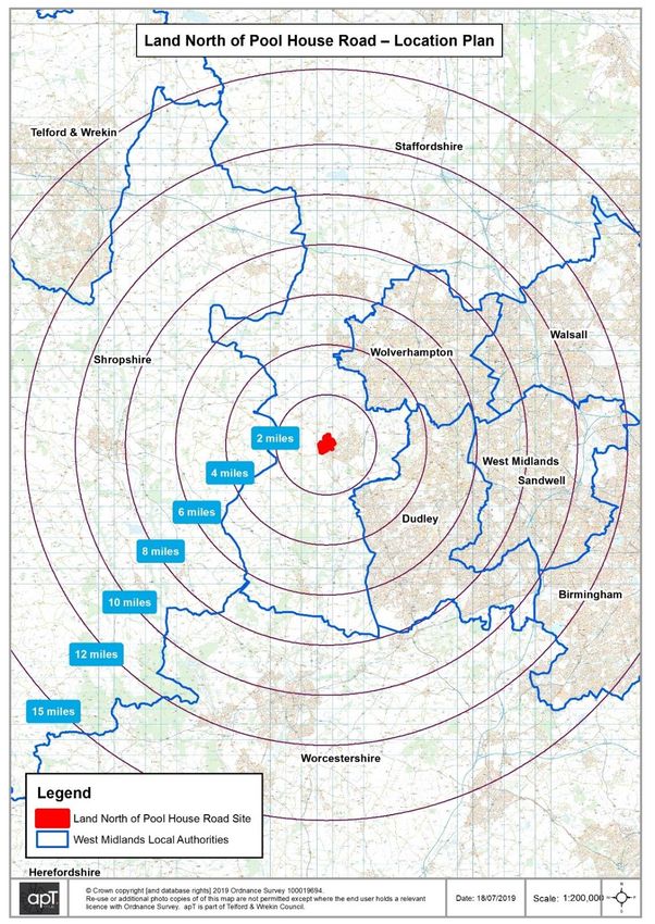
2. Site Location
2.1. The site is located to the west of the village of Wombourne in South Staffordshire
which itself is to the west of the Black Country, separated from the conurbation area
by Green Belt land.
2.2. Wombourne has a population of around 14,000 (2011 Census) with the village being
evenly split by the former railway line, now the South Staffordshire Railway Walk,
which runs north to south. To the west of the line the majority of existing
development is to the south west of the village. Further development in this area is
likely to create an imbalance in the urban form of the village with additional
residential areas being further from services and facilities.
5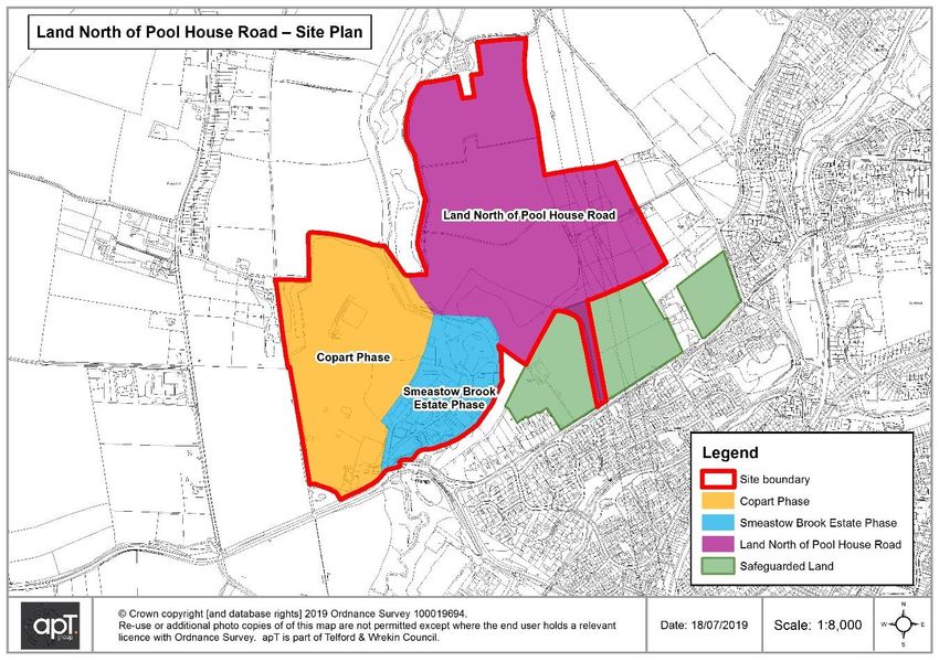
Masterplan and Phasing Report
Land at Pool House Road, Wombourne
PLAN 1 - LOCATION PLAN OF SITE
2.3. The proposed development site is made up of 3x parcels of land. These are:
Copart
Land North of Pool House Road
Smestow Brook Industrial Estate
6
Masterplan and Phasing Report
Land at Pool House Road, Wombourne

    2.4.   The Copart and Smestow Brook portions of the site are accessed off the B4176
           Bridgnorth Road and the Land North of Pool House Road is accessed from a point
           midway along Pool House Road. The site is within the West Midlands Green Belt,
           this includes the brownfield parcels of the site.

    2.5.   There are three existing safeguarded development sites which adjoin Pool House
           Road, these are located to the south of the proposed site allocation. The three sites
           were safeguarded in the Council’s Site Allocations Document (site references 285,
           459 and 415) and removed from the West Midlands Green Belt. Future access to
           the Land North of Pool House Road is through the larger of the three development
           plots and land has been retained within the control of the site promoter for this
           purpose.

    3. Site Constraints

    3.1.   The site has a number of constraints which are discussed in more detail in the
           technical reports annexed to this document. These include topographical,
           geotechnical, ecological, drainage and highway constraints; however, the technical
           reports conclude there are no overriding constraints affecting overall site delivery.

    3.2.   In summary the site is has some historical constraints associated with former uses
           including ground conditions and use as a landfill. Physical access to the 3x parcels
           of land for residential development is also a constraint that is addressed in more
           detail below. Landscape sensitivity has been raised as an issue in relation to local
           conservation areas and views towards Wombourne. There are no constraints that
           would prevent the allocation of the site for residential purposes as it is possible to
           design and engineer out existing issues.

    3.3.   The plan below highlights the areas of previous landfill.

    7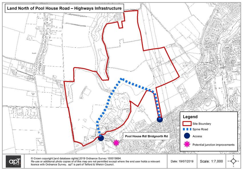
Masterplan and Phasing Report
Land at Pool House Road, Wombourne
PLAN 2 – FORMER LANDFILL SITES
3.4. Consideration of site constraints and opportunities include:
A strong relationship with safeguarded land to the east. This provides opportunities to
connect with the built form along Pool House Road
Drainage solutions – there are some changes in levels across the three sites. There
is an opportunity for SuDS to be designed into future development
Public rights of way and overhead pylons crossing through parts of the site –
diversion and/or integration of these routes into the scheme design will be required
Smestow Brook – this water feature divides the site areas. There is scope to open up
the small river and integrate it as a physical feature into the scheme design
The site includes parcels of previously developed land – development of the whole
site brings the potential to reuse large areas of this land but remediation works may
also be required
Integrating Smestow Brook, hedgerows, trees and other natural features into a
comprehensive green network, together with public open space provision
Site accessibility – utilising existing junction access from the B4716 Bridgnorth Road
and providing connectivity for pedestrians and cyclists between the site, safeguarded
land and services and facilities in Wombourne.
4. Site Description
4.1. Land north of Pool House Road comprises a substantial area of previously
developed land plus a remaining portion of greenfield land. These two areas are
separated by Smestow Brook which runs north to south through the site. The site
comprises of 3x parcels of land which are described below:
8
Masterplan and Phasing Report
Land at Pool House Road, Wombourne
PLAN 3 - LAND PARCELS
4.2. Copart
Position and current usage - this portion of the site is located to the far west of the
overall site and consists of previously developed land that is currently occupied by a
car storage yard. The current occupiers have secured an alternative site with which
to relocate the business. The alternative site is at Meaford in Staffordshire and the
Copart Business is in the process of submitting a planning application to enable
relocation. The site is cleared and is ready to be developed so there are no issues of
relocating existing users in this case.
Previous usage – the site was previously used as a cement pipe works; however,
this has not operated for several years and most buildings that were associated with
this use have now been cleared.
Current access - access to the site is via a single junction off Bridgnorth Road which
is shared with the Smestow Brook Business Park.
Adjoining land - the site is bounded by agricultural land to the west and north, by
the Smestow brook and Industrial Estate to the east and by Bridgnorth Road to the
south.
Topography – the site consists of relatively flat platforms of land associated with the
previous uses and sits above Smestow Brook Industrial Estate.
9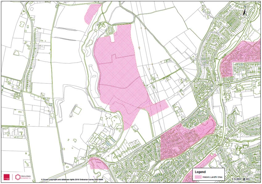
Masterplan and Phasing Report
Land at Pool House Road, Wombourne
4.3. Land North of Pool House Road
Position and current usage – The parcel sits to the north west of 2x brownfield
parcels of the overall site and comprises green fields used as grazing land.
Previous usage – the site is a former landfill and the Environment Agency have
confirmed that the fill is inert material which predominantly consists of construction
waste.
Current access – the land is accessed off Pool House Road via an access road
which has been retained by the site promoter for the purposes of developing this site.
Adjoining land – the site is bounded to the south and west by Smestow Brook, the
north by an existing farm and to the east by grazing land. This portion of the site sits
directly above 3 x plots of safeguarded land which have been identified in the current
South Staffordshire Site Allocations Document.
Topography – access to the site is relatively flat and rises up to the north with main
body of the site before slopping down again mid-point. The western side of the site
falls away towards the Smestow Brook.
4.4. Smestow Brook Industrial Estate
Position and current usage – the parcel of land represents the middle portion of the
overall site and is currently occupied by an Industrial Estate which consists of small
business units, a children’s play barn, storage yards, vehicle repair centres and
haulage yards. The site promoter is working to facilitate the relocation of these
businesses.
Previous usage – the previous use of the site would have been associated with the
adjoining cement works and as such it remains brownfield land.
Current access – the site shares the same access point as the Copart site from
Bridgnorth Road which then splits to provide separate access points for both Copart
and the business park.
Adjoining land – the site is bounded to the west by Copart and to the north, east
and south by Smestow Brook.
Topography – this parcel of land sits at a lower level than the Copart site and
consists of relatively flat platforms of land, this is evidenced by existing industrial /
commercial buildings onsite. The land falls from south to north towards the Smestow
Brook.
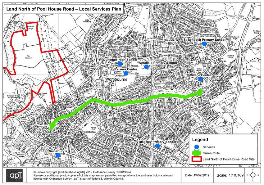
5. Proximity to Local Services
5.1. Wombourne is a large village and has a wide range of community facilities and
services to serve residents’ daily needs. The village also has a strategic role serving
smaller outlying villages and hamlets. The site is close to employment and retail
along the B4176 Bridgnorth Road, including the main local Sainsbury’s supermarket.
10Masterplan and Phasing Report
Land at Pool House Road, Wombourne
5.2. The location of the site presents the opportunity for off-road access into the village
centre via the Wom Brook. Local education and leisure facilities are located further
along Pool House Road, this includes both primary and secondary provision as well
as Wombourne Leisure Centre. The site benefits from relatively good pedestrian and
vehicle access to Ounsdale High School together with shops and services along
Planks Lane.
5.3. In summary the site is well connected to services, facilities and retail opportunities
that Wombourne has to offer and most provisions can be reached on pavement or
offroad with Wombourne’s network of foot paths.
PLAN 4 - LOCAL SERVICES
Table 2. Distances to Local Services
Facility / Service Approximate Distance (as the crow
fly’s)
Primary School 1.6km
Secondary School 1.3km
Village Centre 2.1km
Supermarket 1km
Leisure Centre 1.4km
Employment Park 0.9km
11Masterplan and Phasing Report
Land at Pool House Road, Wombourne
6. Housing Requirement and Site Yield
6.1. The Local Plan Review issues and options consultation identifies a minimum
housing need of 5,130 dwellings over the plan period 2018-37 (270 per annum).
This figure is based on the national standard method of assessing housing need as
set out in the NPPF and guidance. The Council’s preferred level of future growth at
this stage is 9,130 dwellings (481 per annum) which meets the districts objectively
assessed housing need and includes an additional 4,000 dwellings towards the
shortfall from the Greater Birmingham Housing Market Area.
6.2. South Staffordshire Council have undertaken a Strategic Housing and Economic
Land Availability Assessment (SHELAA) which is an assessment of housing and
employment land availability. Several sites including land at Wombourne have been
submitted to the ‘call for sites’ and they have been assessed by the Council. The
process does not allocate housing and employment sites – this is still to be
determined by the Council. It does however make realistic assumptions about the
availability, suitability and likely economic viability of sites.
6.3. The assessment applied developable area and density assumptions for housing
sites that were submitted to the Council. For sites greater than 2 hectares a 60%
ratio is applied to calculate the net developable area, given that allowances need to
be made for open spaces, access roads and infrastructure. Site specific features
could impact net developable areas.
6.4. The density assumptions used in the assessment are based on an analysis of
average densities across historic schemes in the district.
Table 3. Sites Densities
Density assumptions (dwellings per net developable hectare)
Village edge/isolated greenfield sites 32 dph
Sites within existing village envelope/brownfield sites 38 dph
Sites on the edge of an adjacent urban area (e.g. the Black 35 dph
Country)
6.5. The Local Plan review issues and options consultation also proposes an option of
adopting a 35 dph minimum density standard for new housing sites.
6.6. Land to the North of Pool House Road comprises 3x parcels of which fall into
different density types. For the purposes of this assessment they have been
grouped into three broad areas – the Copart site, Smestow Bridge Industrial Estate
(both brownfield sites on the edge of a settlement) and the greenfield land to the
north of Pool House Road. Using the Council’s SHELAA site assessment
methodology, various dwelling yields have been calculated with a preferred
combination based on the land types.
12Masterplan and Phasing Report
Land at Pool House Road, Wombourne
Table 4. Site Yield – Land North of Pool House Road
Site Site Area Net Density Assumption Density Yield
(hectares) Developable (adapted from the (dwellings)
Area Strategic Housing and
(hectares) Economic Land
Availability Assessment)
Copart 23.34 14 32 dph - village edge site 448 dwellings
Greenfield 14.66 8.8 32 dph - village edge site 282 dwellings
land
Smestow 6.64 4 32 dph - village edge site 128 dwellings
Bridge
Industrial
Estate
Total 858 dwellings
6.7. While the Copart and Smestow Bridge Industrial Estate are brownfield sites, they
are located on the edge of Wombourne and would require a comprehensive
landscape design solution. Development could be phased throughout the parcels
with variation in densities as a response to its edge of village context. A lower
density could be applied along the outer site edges, for example, as a response to
the boundary edges. The proposals for land north of Pool House Road have
therefore applied a 32 dwellings per hectare density assumption for the whole site.
While the estimated yields are slightly lower on the brownfield parcels than the
SHELAA findings, these calculations are considered to be reasonable having been
based on the SHELAA assumption of 60% gross to net developable area, the 32
dph density calculation, and initial findings from the site assessment work.
6.8. The Council acknowledges these assumptions can only be considered starting
points for estimating site capacity; however, they give a broad indication of likely
yield which can be taken forward for consideration and subject to further technical
assessments.
6.9. The Local Plan issues and options consultation proposes that Wombourne is a Tier
2 settlement, below the Tier 1 level of settlements but still with a range of services
and facilities. Several of the growth options include Wombourne as a potential
settlement to accommodate a proportionate level of growth, but no figures have
been suggested. Both the preferred level of housing growth and distribution strategy
are yet to be agreed by the Council. Further information will be provided on
settlement capacity in the autumn 2019 consultation on strategic spatial strategy and
infrastructure delivery.
7. Vision and Masterplan
7.1. This site offers a generational opportunity for the Council and community of
Wombourne to achieve a sustainable level of growth within the local area that meets
the needs of future generations for quality affordable housing. The site also provides
a real opportunity to capture the infrastructure benefits that development at an
appropriate scale can provide for the existing community of Wombourne as well as
new residents. A positive approach from the Council, community and stakeholders
13Masterplan and Phasing Report
Land at Pool House Road, Wombourne
will help regenerate this area brownfield land and open up the north west of
Wombourne for everyone’s benefit.
7.2. The vision for the delivery of the site would be as one whole development
opportunity this is supported by the following rationale:
The site delivers a yield of approximately 858 dwellings based on 32 dwellings
per hectare, a level of development that is consistent with the emerging Local
Plan review and the Council’s preferred strategy for future development.
The site has the potential to deliver local infrastructure benefits such as a safer
highways network, onsite allotment provision and improved access to the
Smestow Brook Local Nature Reserve.
The site, as a whole, supports the wider delivery of development opportunity to
the west of Wombourne and re-balances the urban form of the village which is
currently heavily weighted to the east. It also support a more comprehensive
‘master planned’ approach to development when considered alongside the
development potential of the existing safeguarded sites along Pool House Road.
This development opportunity to the west of the village will also help protect the
West Midlands Green Belt and provide the Council with a more robust position in
resisting development between the conurbation and Wombourne to the east.
The site is a major opportunity to regenerate and integrate a brownfield site on
the edge of the village, an allocation that would provide certainty to the Council
and the community around the long term use of the site. Without an allocation the
relocation of Copart is still likely to go ahead with the prospect of a derelict,
vacant site on the edge of the village.
The site as a whole is well connected to the local area and provides the
opportunity to open up access to the countryside to the north of Wombourne. The
access to green space could be managed either by the Council or directly by
future development partners.
14Masterplan and Phasing Report
Land at Pool House Road, Wombourne
PLAN 5 – SITE MASTERPLAN
8. Site Phasing
8.1. The following assessments analyse how the sites work sequentially starting with the
Copart site, followed by the Copart + Greenfield land and finally the overall site
which includes all 3x parcels of land. It looks at the relative benefits and challenges
provided by each scenario. The phasing strategy is based on initial highways
assessments which indicate approximately 300 dwellings can be served off a single
access point. The Copart site capacity could therefore be delivered in the first
phase, with development of the Greenfield land coming forward next and utilising
access from the safeguarded Green Belt sites off Pool House Road. Smestow
15Masterplan and Phasing Report
Land at Pool House Road, Wombourne
Bridge Industrial Estate would form the third and final phase for overall site delivery,
with the internal link road connecting through from the Greenfield land.
Table 5. Copart
Site Site Summary
Opportunities
Housing 448 homes including affordable provision
Regeneration Regeneration of large brownfield site on the edge of the village
Infrastructure Highway improvements on Bridgnorth Road and Pool House
Road junction and need for connection to Pool House Road to
deliver all 448 homes.
PLAN 6 - COPART LAND
8.2. As an allocation on its own, the Copart site delivers a yield of 448 dwellings at a rate
of 32 dwellings per hectare.
8.3. Delivery of the Copart site on its own would enable the regeneration of a significant
area of brownfield land which currently sits outside the Wombourne settlement
boundary. The site is likely to have limited future potential as a ‘quality employment
site’ due to the nature of the previous and current uses which would have an impact
on viability. Developing the site for residential uses is likely to increase the
deliverability of the site through increased land values to offset any remediation
costs.
16Masterplan and Phasing Report
Land at Pool House Road, Wombourne
8.4. At 448 dwellings the site cannot be developed in its entirety off a single point of
access. Staffordshire County Council highways use a measure of 300 dwellings off a
single point of access and the Copart site could be developed up to this threshold
with a single access point. To deliver the remaining 148 dwellings a second access
would be required off Pool House Road which connects the remaining phases of the
Copart site with the Greenfield area of land. A second access of Pool House Road
would also enable the release of Smeastow Brook Industrial Estate site and the
delivery of a further 128 dwellings.
8.5. The delivery of a viable residential scheme onsite will limit the delivery of green open
space provision and prevent the delivery of additional community benefits such as
allotments that could be delivered on the overall wider site. This could potentially be
offset by providing improved access to the Smestow Brook Local Nature Reserve,
ensuring there are play facilities on site and managing development areas to
maximise the usable open space. Good links into Wombourne for walking and
cycling would need to be considered so that residents can access a typology of
parks.
8.6. A serious draw back to the delivery of the Copart site, in isolation, is the resulting
disconnect with Wombourne. The site would sit clearly outside the built form of the
village and it would be far more difficult to achieve sustainable links into the village
with missed opportunities for access via Land to the North of Pool House Road. The
site would also sit next to a commercial / industrial park with potential issues
associated with the proximity of those uses such as noise, dust, vehicle movements
all impacting on the lives of incoming residents.
8.7. Pedestrian, cyclist and vehicle traffic will all access Wombourne from the existing
Bridgnorth Road access. This is problematic when the Bridgnorth Road sweeps
down towards Wombourne and will make access for pedestrians and cyclists
(especially elderly and younger residents) more difficult, thereby increasing the
likelihood of residents travelling by car for even short journeys.
8.8. Allocation of the Copart site in isolation will be a significant missed opportunity for
the Council and community. It will result in piecemeal development of sites within the
area including; the increased likelihood of the Smestow Bridge Industrial Estate
being redeveloped for residential uses, at a later date, as well as the delivery of the
safeguarded land on Pool House Road. This approach will reduce the Council’s
ability to secure a ‘future proofed’ area that has been master planned to deliver a
range of infrastructure improvements at scale such as highway improvements,
sustainable transport links and community uses. Where sites come forward without
a clear overall infrastructure led strategy the Council are likely to have to ‘gap fund’
infrastructure provision as sites are far less likely to relate to each other.
17Masterplan and Phasing Report
Land at Pool House Road, Wombourne
Table 6. Copart + Land North of Pool House Road
Site Site Summary
Opportunities
Housing 730 homes including affordable provision
Regeneration Regeneration of a large brownfield site on the edge of the village
Scope for a more ‘finished’ urban form when linked to
safeguarded sites.
Infrastructure Opportunity for a site link road providing an alternative route
through to Bridgnorth Road in the event of accidents
Provision of onsite allotments to meet community needs
Strategic opportunity to secure wider infrastructure benefits from
site + safeguarded land
PLAN 7 - COPART + LAND NORTH OF POOL HOUSE ROAD
8.9. An allocation covering Copart and land north of Pool House Road could deliver a
total of approximately 730 dwellings.
8.10. This approach would bring in land north of Pool House Road as a second phase of
site development. Access to this second phase would be provided off Pool House
Road via the safeguarded sites that have been removed from the Green Belt. An
internal link road would connect land north of Pool House Road with the Copart site.
8.11. Although the delivery of 730 dwellings should be feasible it is not the most optimum
solution because it removes the opportunity to bring forward additional brownfield
18Masterplan and Phasing Report
Land at Pool House Road, Wombourne
land within the overall scheme as part of an overall masterplan. The result instead
will be piecemeal (Industrial Estate remaining in the centre of a residential area)
development which misses the opportunity to deliver a comprehensive scheme
through the internal link road.
8.12. The development of Copart and Smestow Bridge Industrial Estate would exceed the
Staffordshire County Highways guidance thresholds off a single access point. This
would place a greater strain on the junction of Bridgnorth Road and Pool House
Road which becomes an even greater potential single point of failure on the local
highway network in the event of an accident or need for maintenance works.
Instead, it is proposed to bring forward development of the greenfield land north of
Pool House Road which could provide a link to the Copart site as a means of
delivering a comprehensive approach to improvements in the area.
8.13. The inclusion of the greenfield parcel will provide extensive areas of green open
space which can be made publicly accessible. This space provides a green buffer
between proposed areas of development and existing Green Belt to the north of the
village. The space can be used to plant appropriate levels of screening to protect
sensitive view looking towards Wombourne, landscape mitigation can also be
provided by setting development on the greenfield parcel down by re-profiling the
landscape. Open space also provides the opportunity for community input into the
planning process to determine what benefits they would wish to see such as the
provision of allotments which could be managed for benefit of the whole village.
8.14. A greater scale of development which combines both sites will have some additional
benefits. These are mainly generated by the potential for more open space across
the site, a more finished urban form (including the safeguarded sites) and a more
favourable position in terms of securing offsite infrastructure improvements.
8.15. The challenge presented by allocating the two parcels of the overall site is that the
Copart site could still be seen as isolated from Wombourne by the Smestow Bridge
Industrial Estate. The potential issues of noise, dust and vehicle movements from
the industrial estate could still arise in this scenario, impacting on both residents and
businesses.
Table 7. Copart Site + Land North of Pool House Road + Smestow Brook Industrial
Estate
Site Site Summary
Opportunities
Housing 858 homes including affordable provision
Regeneration Regeneration of 2x large brownfield sites on the edge of the
village
Open up access to the former (inert) landfill site to the north as
green open space
Better sustainable travel links between brownfield sites and
services and facilities in Wombourne
Infrastructure Maximised highway improvements on Bridgnorth Road and Pool
House Road junction
19Masterplan and Phasing Report
Land at Pool House Road, Wombourne
Opportunity for a site link road providing an alternative route
through to Bridgnorth Road in the event of accidents
Provision of onsite allotments to meet community needs
Strategic opportunity to secure wider infrastructure benefits of
safeguarded land such as education contributions
Opportunity to design a comprehensive ‘green infrastructure’
solution which minimises the visual impact of proposals and
maximises opportunities for public benefit.
Improved public access to Smestow Brook
PLAN 8 - COPART + SMESTOW BROOK INDUSTRAIL ESTATE + LNPHR
8.16. The overall site can deliver approximately 858 dwellings as an allocation and this
would meet emerging local housing requirements. Allocation of the 3x parcels of
land will have significant additional benefits which cannot be achieved with a
piecemeal allocation of only the brownfield sites.
8.17. In terms of highways benefits the overall site could deliver a link road from the
Bridgnorth access via a bridge across the Smestow Brook and connecting in with
Pool House Road. This would enable the delivery of a greater number of units
across the site as well as providing a suitable alternative route for traffic from
Wombourne out to towards Bridgnorth should it be required. The Copart site could
be released in part with the delivery of the remaining brownfield land being enabled
via the construction of a link road between the Copart site and the Land North of
Pool House Road.
20Masterplan and Phasing Report
Land at Pool House Road, Wombourne
8.18. The 3x parcels of land allocated as a whole will provide a greater critical mass from
which to secure developer contributions for offsite infrastructure such as highways,
education and sustainable travel improvements. This is a generational opportunity to
secure a safe, robust and future proofed highway network and address public
perception of highway safety in this area of the village. The inclusion of the green
field land parcel will help facilitate better access by sustainable modes of travel into
Wombourne from the Copart and Smestow Bridge sites via the green field land and
through appropriate infrastructure to enable residents to cross Pool House Road
safely.
8.19. A more strategic approach to allocating land within Wombourne will help rebalance
the urban form of the village towards the west whilst maintaining good access to
services, facilities and recreation opportunities. This should be done alongside the
formal allocation of the safeguarded land along Pool House Road to provide the
community with a clear indication of where development will go and what
improvements will come with it.
9. Onsite Infrastructure
9.1. At 858 dwellings the site offers an opportunity for small scale retail focussed at the
core of the site or closer to the main access off the Bridgnorth Road to address
passing trade.
9.2. An overall green infrastructure offer could include:
Meeting the village need for allotment spaces and associated parking spaces
Access to green open space for the whole community – with a variety of
management options available from a dedicated management company,
community led approach to Council adoptions
Potential for improvements to the Smestow Brook Local Nature Reserve
Onsite play and parks facilities to meet local needs
Appropriate screening for development to address issues of landscape sensitivity
especially to the north of green field land.
Potential for offsite contributions towards education provision
9.3. Allotments - South Staffordshire Council published a draft Allotment Strategy in
2011, although it has never been formally adopted. The most recent open space
audit, in the Open Space Strategy 2014-28 identified one allotment site in the
Wombourne North & Lower Penn ward. There were no allotments in the
Wombourne South East and South West wards.
9.4. The Council’s open space policies do not include an allotment standard; the need for
allotments within a village will be led by locally identified demand. On site provision
or contributions to improve existing facilities will be sought if a local need for such
facilities has been identified. Consultation with the relevant Parish Council and local
community will be the starting point for identifying such needs. It is clear that the
21Masterplan and Phasing Report
Land at Pool House Road, Wombourne
potential areas of open space on this site could provide an excellent opportunity to
meet local need.
9.5. Education – An estimate has been calculated of pupil demand generated by the
proposed development and safeguarded land along Pool House Road. This
estimate is based on the dwelling mix assumptions in the Council’s Long Term
Balancing Market Housing Report (2017). Following these assumptions it is unlikely
that the generated demand would require on-site primary school provision. Any
surplus provision in the local catchment area would need to be considered and it is
therefore likely that developer contributions would be required towards either
existing or new education facilities.
10. Transport
10.1. The highways infrastructure plan for the area is provided in Plan 9.
PLAN 9 – HIGHWAYS INFRASTRUCTURE PLAN
10.2. With a development of this size first principles would suggest that significant junction
upgrades would be required for both the site access locations and other key
locations on the local highway network. At this stage it is difficult to draw any firm
conclusions on what would specifically be required and where. Therefore a transport
model such as PTV Vissim would be required to comprehensively map the existing
22Masterplan and Phasing Report
Land at Pool House Road, Wombourne
transport movements and forecast the development impact on the village and
surrounding area including those routes into the West Midlands conurbations.
10.3. Delivering a sustainable development is also key and therefore it is acknowledged
that walking and cycle connectivity requires a detailed appraisal and new
infrastructure, including the upgrade and enhancement of existing facilities would be
necessary. Discussions will also be held with the local public transport operators
regarding the improvement of local bus links and associated bus infrastructure with
a view to hopefully providing a bus service through the development site itself. Any
future planning application on the site would be supported by a comprehensive
sustainable transport and travel plan strategy.
11. Drainage
11.1. A summary of the Drainage note is provided below.
11.2. The report is a desk study that has been produced to identify any key development
constraints and opportunities in relation to drainage for the site and its 3x parcels of
land. The report is high level as there are no detailed development layouts are
available at the time of writing the report.
11.3. Smestow Brook
11.3.1. The Smestow Brook is an important feature within the site and is also a
Biological Alert site; the development should maintain and enhance the
watercourse valley as a blue/green corridor as public open space. If possible, a
wider watercourse corridor should be provided along the site’s southern
boundary. This can easily be accommodated within the current proposals.
11.4. Flood Risk
11.4.1. The mapped flood risk to the site from rivers and reservoirs is shown to be
contained to the Smestow Brook watercourse valley. Reservoir flooding may
affect a small area along the southern boundary of Smestow Brook Business
Park, however the majority of the overall site is not within river or reservoir flood
zones. Some localised surface water flooding and flow routes are mapped
affecting the site, however this can be accommodated by considering the flow
routes within a site design.
11.5. Drainage
11.5.1. Given the historic and current site usages and the Principal Aquifer underlying
the site, infiltration drainage is extremely unlikely to be suitable and the
Smestow Brook should be seen as the best point of outfall in accordance with
the Drainage Hierarchy. Surface water discharge from the site should be
restricted as close to greenfield runoff rates as possible. Preliminary estimations
of discharge rates and corresponding attenuation volumes for each
development phase have been calculated to provide an indication of what
volume of surface water attenuation will be required.
23Masterplan and Phasing Report
Land at Pool House Road, Wombourne
11.5.2. Any development of the site should utilise SuDS for surface water drainage,
providing multiple benefits e.g. water quality treatment for any development
highway. Any SuDS serving should not be located in Flood Zones 2 or 3a. The
Masterplan does not identify any space for SuDS within the development and
space for drainage infrastructure will need to be identified when developing the
site design further. Any SuDS features would likely need to be lined because of
ground conditions.
11.5.3. There are no existing public sewers within the development site, although it is
expected that there are existing private foul and surface water drainage
systems within the existing industrial estate. The industrial estate is served by
mains water and a main is located under the B4167.
11.6. Connecting the 3x parcels of land
11.6.1. The development proposals include a highway over the Smestow Brook
linking the brownfield and greenfield areas of the overall site. This will need to
be designed with consideration of existing flow routes and levels, the site’s
Biological Alert Site status and the modelled flood zones. Any feature crossing
the watercourse will require a permit from the Environment Agency and will
likely require flood modelling to demonstrate that proposals do not affect flood
flows down the watercourse.
11.7. Former Landfill
11.7.1. The former landfill site and any SuDS and drainage will likely require
excavation into this landfill material. How this can be achieved will need to be
carefully considered. Any SuDS features would need to be designed to account
for loading and settlement from storage of large volumes of water. Engineering
costs associated with this parcel are therefore expected to be abnormal.
11.7.2. In conclusion, no major drainage constraints have been identified in
brownfield parcels of land although a number of features and conditions will
need to be considered within the site design as this develops.
12. Geotechnical
12.1. A summary of the geotechnical note is included below.
12.2. Draft master plan
12.2.1. Substantial demolition and clearance of Copart and Smestow Bridge
Industrial Estate, which include buildings, hard standings and services within
these areas will be necessary. Based on the modern industrial use of this land,
contamination is more likely to be an issue in this part of the site. Furthermore,
the north-western parts of Phase 1 area have been extensively quarried and
subsequently infilled with landfill. As such, more extensive remediation and
more extensive foundation measures may be necessary. Also, the surface
water flood risk map indicates that the northern part of Phase 1 will be prone to
flooding and specific measures may be necessary to address this issue. Phase
2 is located at the southern end of the north-eastern part of the site. Although
this part of the site currently appears as open green fields, the entire area
24Masterplan and Phasing Report
Land at Pool House Road, Wombourne
appears to have been subjected to extensive quarrying and subsequent infilling
with landfill. As such, more extensive remediation and more extensive
foundation measures are likely to be required.
12.3. Ground contamination issues
12.3.1. Many of the current operators on the industrial estate could give rise to
significant contamination issues. Given the extent of the various automotive
works (scrap yards), it is anticipated that the greatest concern will be from
various hydrocarbons ‘leaking’ into the surface soils. Similarly, the various
areas of extensive landfill within the site represent significant risks and are likely
to require further studies in advance of a planning application.
12.4. Topography
12.4.1. Generally speaking, the south-western part of the site falls easterly towards
Smestow Brook, whilst the north-eastern part of the site falls westerly towards
Smestow Brook. Given the relatively gentle topography, modest earthworks
should be possible to create the proposed development platforms.
12.5. Geology
12.5.1. Based on the preliminary information available, it would appear that the
prevailing ground conditions are likely to comprise varying amounts of Made
Ground materials (backfilled quarries and landfills) overlying predominantly
granular natural superficial deposits (sands and gravels), which in turn overly
sandstone bedrocks. Locally, immediately adjacent to the route of the Smestow
Brook, the natural superficial deposits are likely to be me more cohesive clays
(Alluvium).
12.6. Further studies
12.6.1. Further studies will inevitably be required to bring the development forward to
detailed design. These studies will need to include detailed topographical
surveys, comprehensive geotechnical desk study and site specific ground
investigations to determine the prevailing ground conditions and geotechnical
parameters for design. The specific requirements for each development site
should be determined as part of detailed geotechnical desk study works.
13. Ecology
13.1. A summary of the ecology note has been included below.
13.2. The following features have been identified 2km or more from the site:
No Special Areas of Protection (SPA), Special Areas of Conservation (SAC) or
Ramsar sites within 5km of the site.
No SSSI within 2km of the site:
o ‘Highgate Common’ SSSI is located approximately 2.5km to the south west of
the site, and
o ‘Gospel End Road Cutting’ SSSI is located approximately 5km to the east of
the site.
25Masterplan and Phasing Report
Land at Pool House Road, Wombourne
No National Nature Reserves within 2km of the site.
‘Wom Brook Walk’ and ‘South Staffordshire Railway Walk’ Local Nature
Reserves are located within 2km of the site. Neither site is located within, or
immediately adjacent to, the site.
13.3. The following has been identified within 2km of the site:
• Four Local Wildlife Sites and one ‘Biodiversity Alert Site’ are located within 2km
at:
o Staffordshire and Worcestershire Canal:: Penn Substation
o The Grotto, Trysull
o Heath Mill and Smestow Mill Smestow Brook, and
o Himley Planation
13.4. The following has been identified adjacent to or partially within the proposed site
(Phases 1 – 3):
One Local Wildlife Site is immediately adjacent to the site, ‘Feiashill’. This site
was declared as a Local Wildlife Site in 1996.
A single Biodiversity Alert Site ‘Woodford Grange and Smestow Barn’ is presently
partially within, and immediately adjacent to, the site
14. Alternative Sites
14.1. An analysis of alternative sites included within the SHELAA in the table below.
Table 8. Summary of Alternative Sites
SHELAA Comment
reference /
site name
280 - Land Although the site is within the development boundary of Wombourne it has
at the existing constraints that make sustainable development difficult not least its
Bratch location in relation to Bratch Locks and the listed pumping station onsite.
The site would lend itself well to more tourism related development that
could open up the site which sits between two of Wombourne’s most
valuable assets being the canal and the South Staffordshire Railway Walk.
Highways access to the site is potentially difficult with access onto any of
the surrounding roads leading to disruption for existing residents from either
through traffic or changes to the network.
283 - Land The site is in Green Belt land and outside of the development boundary.
off Development at this location will start to signal a coalescence of the village
Bridgnorth with the conurbation area. The site is also adjacent to the Sytch Lane
Road Cemetery and once the proposed site had been completed the cemetery
will be surrounded by residential development on 3 sides and a Livery /
Agricultural Yard. Although the site is adjacent to the urban area it remains
relatively isolated from Wombourne with access likely to be achieved via
the Bridgnorth Road.
416 – Land Development of this site would start to see a finger of development
off Orton extending to the north of Wombourne. This appears to be a relatively
Lane remote proposal that does not contribute to the logical form of the village.
26Masterplan and Phasing Report
Land at Pool House Road, Wombourne
Part of the site is safeguard land with approximately a quarter of the site
being made up of additional land in the Green Belt.
463 (a, b, c The site would benefit from access onto the Stourbridge Road, however it
and d), 284 signals a willingness for further development in the gap between the village
– Billy Buns and the conurbation. Development at this point is highly likely to lead to
Lane further pressures in the future.
554 – Land The site is within close proximity of Bratch Locks conservation area. It
off Trysull represents an expansion into the Green Belt that is on a wholly greenfield
Road site and does not provide a logical form to the village with further pressure
for infill development in the area in future years. A potentially piecemeal
approach to development in the area will water down the Council’s ability to
secure an infrastructure led strategy and negate the benefits of a master
planned approach.
626, 627, The proposed sites collectively represent a major extension to the south
628, 629 – west of Wombourne. The sites are greenfield open land within the West
Land off Midlands Green Belt that if delivered would bring Wombourne much closer
Bridgnorth to the village of Swindon to the south. It would then be difficult for the
Road Council to resist further pressure in the future to bring the two settlements
(Parcels a, together, as part of future Local Plan work. This site does not provide any
b, c and d) benefits arising from the delivery of a brownfield site such as the Land
North of Pool House Road.
15. Performance against Green Belt objectives
15.1. The sites identified above have been included along the Land North of Pool House
Road to assess them against the 5 Green Belt objectives in the NPPF. A table
summarising the results is included in Annex F to this document. The table
demonstrates that of all the major sites around Wombourne the Land to the North of
Pool House Road performs the best against the 5 objectives of the Green Belt as
summarised below:
1. Check the unrestricted sprawl of large built-up areas – The site represents an
extension to the north west of Wombourne - opposite side of village to the West
Midlands conurbation
2. Prevent neighbouring towns merging into one another – There are no
implications for merging the gap between Wombourne and the West Midlands
3. Assist in safeguarding the countryside from encroachment – There is limited
scope for further development beyond proposals due to the presence of natural
barriers
4. Preserve the setting and special character of historic towns – A major
developable part of site is brownfield and there is scope to enhance the setting of
the area
5. Assist in urban regeneration, by encouraging the recycling of derelict and
other urban land – The site provides a major opportunity to deliver regeneration
of brownfield land on the edge of the village
27Masterplan and Phasing Report
Land at Pool House Road, Wombourne
16. Conclusions
16.1. It is clear from the analysis provided that Land North of Pool House Road (including
Copart, Smestow Brook Industrial Estate and safeguarded land) works best as a
whole and not as individual parcels of development. The overall site delivers an
opportunity to take a strategic approach to development in Wombourne, in an area
that has already been identified as suitable for development with the designation of
safeguarded land. The site is also suitable as it helps meet the Council’s desire to
protect the Green Belt buffer between the West Midlands and Wombourne as well
as regenerating a brownfield site.
16.2. The analysis provided in the attached notes highlight areas for development and
further investigation. They demonstrate that the site does not have any overriding
physical or environmental constraints that prevent a future allocation and there are
technical solutions to any issues raised that can be dealt with through outline and
reserved matters planning applications.
16.3. The site also performs better on many counts to other proposals in the Wombourne
area which rely on the development of solely green field sites of which a number of
these sites suggest a development strategy that would see Wombourne at risk of
merging with surrounding settlements on the West Midlands conurbation fringe.
16.4. The content of this document establishes that the site is:
Suitable – the site would contribute to overall housing needs by providing a mix of
housing types, tenures and sizes at a scale proportionate with the role and function
of Wombourne; the site’s proximity to services and facilities in Wombourne and
nearby West Midlands conurbations, accessibility by public transport; the Council’s
SHELAA identifies the site overall as ‘potentially suitable’, with general policy
compliance, the main outstanding issue being the Green Belt designation; No issues
were identified in the Council’s Infrastructure Delivery Plan (2018) that could impact
on development of this scale in this location. Together with bringing forward the
nearby safeguarded land, proposals would rebalance the distribution of development
across Wombourne; a comprehensive masterplan-led development would bring
forward housing, infrastructure and open space.
Available – the landowner(s) are willing sellers and have indicated support for
release of the whole site from the West Midland Green Belt; there are no known legal
or ownership issues that preclude the whole site’s development during the Local Plan
review plan period; neither are there any significant overriding physical or technical
constraints preventing delivery during the future plan period.
Achievable – the whole site could be comprehensively developed with a quantum of
development that would deliver benefits both in retaining and enhancing green
infrastructure, together with site remediation and socio-economic benefits in terms of
housing provision and necessary infrastructure contributions.
16.5. The benefits of developing the whole site can be summarised as:
28You can also read


