Middlebank, Dunfermline Vision Document - Response to FIFEplan December 2014 - Fife Council consultation portal.
←
→
Page content transcription
If your browser does not render page correctly, please read the page content below

Middlebank, Dunfermline
                                                                         Vision Document - Response to FIFEplan
                                                                                                December 2014
                                                                                                    Client: CALA Management Ltd
                                                                                                                   Date: 141208

© Crown copyright, All rights reserved 2013. Licence number 0100031673
© Google 2013
N    Not to scale

Middlebank, Dunfermline
pg. 2                     © Crown copyright, All rights reserved 2013. Licence number 0100031673
                                                                                   © Google 2013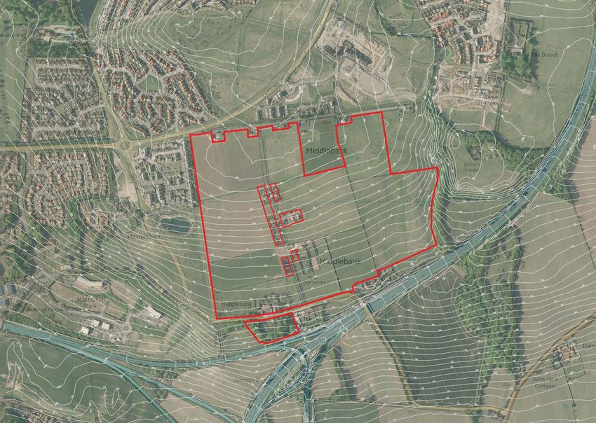
› Vision › Contents
CALA Management (Ltd) (CALA) believes that development at Middlebank 1. Introduction pg. 2 4.2.1 Landform pg. 17
can deliver a unique and distinctive residential development in south east
4.2.2 Slopes pg. 17
Dunfermline. The site presents the opportunity for CALA to provide a low 1.1 Purpose of this document pg. 2
density, high quality residential development of up to 300 homes in a manner 4.2.3 Aspect pg. 17
1.2 Proposed FIFEplan pg. 2
that reflects the high quality of environment in this location. Importantly there 4.3 Views from the site pg. 18
1.3 A design led approach pg. 2
are no obstructions to development at CALA could deliver the proposals in
4.4 Landscape structure pg. 19
the short term. 1.4 Document structure pg. 2
Development at Middlebank is proposed to provide family homes in an 4.5 Access pg. 20
2. Contextual analysis pg. 3
attractive landscape within the context of the Dunfermline Eastern Expansion 4.6 Site viewpoints pg. 21
(DEX). The new homes will be located within a new high quality landscape 2.1 The site pg. 3
4.7 Approach to development pg. 23
setting set against the distinctive backdrop. A series of parkland spaces will
2.2 Planning context pg. 4
allow residents and visitors alike the opportunity to enjoy a new public open 4.8 Appraisal + concept pg. 24
space in this part of the city, revealing views south towards the River Forth 2.3 Existing context pg. 5
and Edinburgh.
5. Development vision pg. 25
2.4 Access pg. 6
Development here can benefit from an accessible location, on a bus route 5.1 Strategy for development pg. 25
2.5 Evolving context pg. 8
and located a short walk from a variety of local shops and primary school in
5.2 Development Framework pg. 25
one of the most successful residential areas in Dunfermline. The proximity to 2.5.1 Area of eastern expansion (DEX) pg. 8
good transport links and a wide variety of employment areas, coupled with 5.2.1 Development capacity pg. 25
2.5.2 Future growth pg. 8
the high demand for housing, means that the site offers a strong development 5.2.2 Landscape framework pg. 27
opportunity in a unique landscape setting. Development at Middlebank can 3. Visual appraisal pg. 9
5.2.3 Access and connectivity pg. 28
help realise the need for more high quality residential development within the
3.1 Landscape setting pg. 9
city and allow the success of DEX to continue. 5.2.4 Pedestrian and cycle access pg. 28
3.2 Viewpoint selection pg. 9
The site at Middlebank has not previous been accepted as a development 5.3 Illustrative Masterplan pg. 29
site as a result of the perceived sensitive nature of the landscape setting. 3.2.1 View from Lapwing Drive pg. 10
5.3.1 Fife Urban Design Guide pg. 29
New development at Middlebank, through its design and contribution to
3.2.2 View from Masterton Road pg. 11
placemaking, should enhance not detract from the character and quality of 5.4 Character and Identity pg. 29
environment. It should be designed to include open space that will positively 3.2.3 View from M90 pg. 12
5.5 High quality new development pg. 31
reinforce the southern boundary to Dunfermline. Further CALA would like to 3.3 Site appraisal pg. 13
see the aspects that make the site unique and attractive brought to the fore, 5.6 Safe and Pleasant Open Spaces pg. 33
3.4 Visual capacity of the study area pg. 14
the distinct features and characteristics of the site are articulated through the 5.7 Easy to Move Around pg. 34
design to create a distinctive new residential area with a clear identity and
4. Site analysis pg. 15
sense of place. 6. Summary pg. 35
4.1 Understanding the study area pg. 15
The following document will describe the approach and principles that CALA 6.1 Summary pg. 35
believe should be followed to allow the land at Middlebank to be allocated for 4.1.1 Existing land use pg. 15
residential development in FIFEplan.
4.1.2 Ownership pg. 15
4.1.3 Existing properties pg. 15
4.2 Topography pg. 17
Middlebank, Dunfermline
© Crown copyright, All rights reserved 2013. Licence number 0100031673
© Google 2013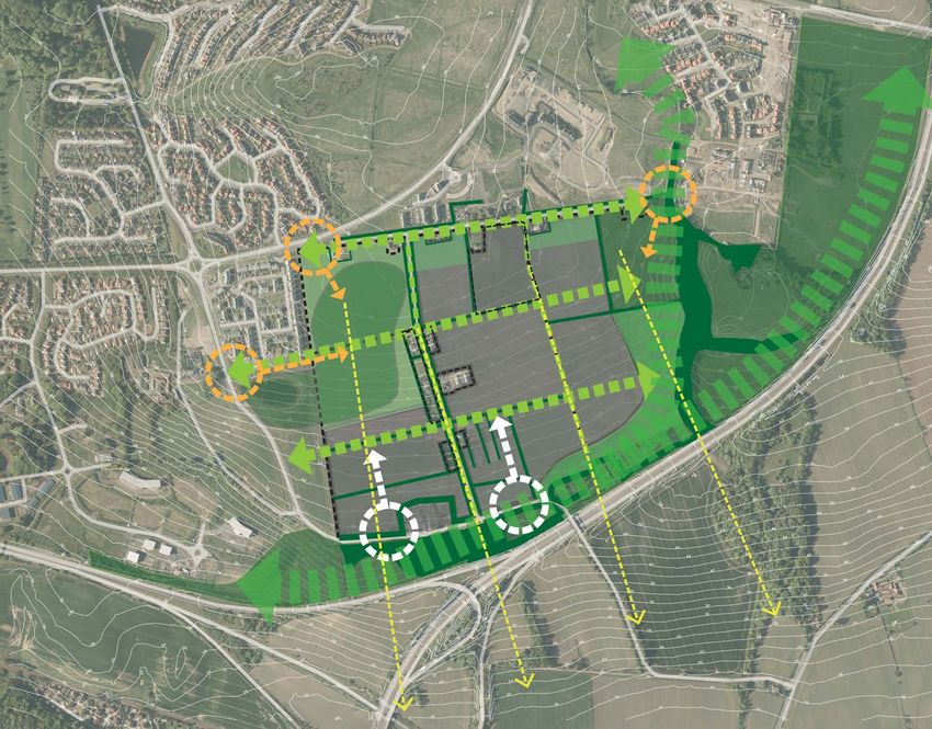
Middlebank
                                site

    N     Not to scale

fig. 1:     Site location.

Middlebank, Dunfermline
pg. 1                                     © Crown copyright, All rights reserved 2013. Licence number 0100031673
                                                                                                   © Google 2013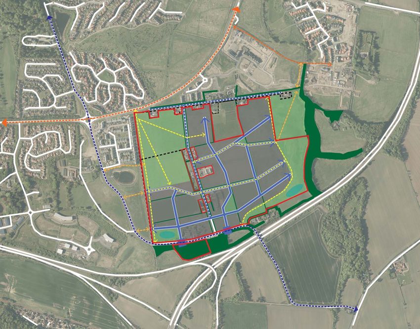
1. Introduction

1.1 Purpose of this document                                                     1.3 A design led approach                                                            1.4 Document structure
This response to the Proposed FIFEplan has been prepared by Optimised            This Vision document describes the proposed site location and its surrounding        The document is presented in a number of sections to clearly establish how
Environments Limited, ‘OPEN’ on behalf of CALA Management Ltd (CALA).            context, it includes a visual and physical appraisal of the site and its environs.   the Middlebank site can provide a high quality development opportunity.
The document forms a supporting statement to accompany CALA’s objection          Through this appraisal, the study then identifies the development capacity           The document is structured as follows;
to the Proposed FIFEplan and promotes the allocation of land at Middlebank,      of the site to accommodate change and concludes with a concept and a
                                                                                                                                                                      Contextual analysis
Dunfermline for the purpose of residential development.                          description of the opportunity for development at Middelbank.
                                                                                                                                                                      This section introduces the study area context, including an overview of the
CALA controls circa 41 hectares of land at Middlebank, to the south east of      The document demonstrates that the overall character and quality of the              landscape planning designations, the landscape setting and how the site
Dunfermline immediately to the south of the identified Dunfermline Eastern       landscape setting will not be unacceptably compromised through careful               relates to the DEX strategy.
Expansion Area (DEX), shown on figure 1 opposite, and has appointed              development and indeed that an opportunity exists to enhance aspects of the
                                                                                                                                                                      Visual appraisal
OPEN, as part of multi-disciplinary design team, to explore the potential for    site including the contribution that it can make towards improved accessibility
                                                                                                                                                                      This section provides a visual analysis of the potential impacts on the
development in this location and to inform its response to the Proposed Local    to landscape and the setting of south Dunfermline.          Following a master
                                                                                                                                                                      surrounding area to inform the visual capacity of the site to accommodate
Development Plan.                                                                planning approach, which considers the study area in a comprehensive rather
                                                                                                                                                                      development.
CALA believes that the site at Middlebank has the capacity to accommodate        than a piecemeal and incremental basis, this approach emphasises landscape

up to 300 family homes which will help to address the acknowledged               capacity, site appraisal, design quality, innovation and sustainability as the key   Site analysis
shortfall in housing provision which has been identified within FIFEplan. This   factors which can achieve this objective.                                            The aim of this section is to identify the sensitivities and opportunities that
representation has been prepared to demonstrate how sensitive development        CALA has appointed a multi-disciplinary team to demonstrate that                     exist in within the site area and its immediate context and identify a physical
on the site can complement landscape setting objectives whilst securing          development at Middlebank is both deliverable and can meet the aspirations           capacity and a preferred approach to development within the site area.
significant wider public benefit in terms of improved open space and green       for good place making enshrined within National and Local Policy
                                                                                                                                                                      Development vision
linkages.                                                                        The team appointed consists of the following:                                        This section of the document sets out the CALA Vision for development

1.2 Proposed FIFEplan                                                            •   Planning: TMS Planning and Development Services (TMS)                            at Middlebank and the opportunities and benefits that it will present.       It
                                                                                                                                                                      describes how the development concept that has evolved from the analysis
                                                                                 •   Masterplanners / Landscape Architects: Optimised Environments (OPEN)
                                                                                                                                                                      and appreciation of the site and its strategic and local context.
FIFEplan sets out the Council’s proposals for the future development of Fife     •   Transport and Engineering Consultants: WSP UK Limited (WSP)
and concentrates on the key changes since the previous Local Plan. The           •   Architecture/Developer: CALA Homes (East) Ltd (CALA)
                                                                                                                                                                      Summary
FIFEplan strategy aims to maintain a strong emphasis on supporting job                                                                                                This section provides CALA’s response to the Proposed FIFEplan and
opportunities through economic growth and the creation of high quality                                                                                                summarises CALA’s rationale for development.
places and sustainable communities through sustainable development.
Currently there are already a number of allocated sites across the Fife region
through the existing Local Plans. At the present the Middlebank site is not
currently included within the draft list of allocated development sites.

                                                                                                                                                                                                                          Middlebank, Dunfermline
© Crown copyright, All rights reserved 2013. Licence number 0100031673                                                                                                                                                                          pg. 2
© Google 2013
2. Contextual analysis
2.1 The site
M90
The site at Middlebank encompasses some 41 ha of largely under utilised Calais Muir
farmland, located on the south eastern edge of Dunfermline. Located Wood
approximately 4km (20min cycle) from Dunfermline town centre the site is
located directly adjacent to the area identified as part of Dunfermline Eastern
Expansion (DEX).
Sandpiper
A minor road divides the site into two parcels of land (north-south axis), Drive
which are referred to as the western and eastern parts respectively. A number
Duloch Leisure
of other residential properties are located along the minor road, which is Centre
accessed via a junction on Masterton Road to the south, and along the north Duloch
Retail
boundary of the site. Park
To the south of the site area there is a small number of private properties set Pitreavie
Primary
with existing mature woodland which define the southern edge of Dunfermline School
to the M90 and A823(M). The railway south of the A823(M) defines the
northern edge of Rosyth.
Masterton
Primary
To the east the site is bounded by existing areas of mature woodland which School
define the fields and surround Duloch House and M90 boundary. Aberdour
Pitreavie Golf Road
The site is bounded by Lapwing Drive to the north, Masterton Road and the Course
M90 to the south and Skylark Road and Merlin Drive to the west. Masterton
Road (which incorporates National Cycle Route 1) connects Dunfermline
across the M90 to Inverkeithing to the south east.
Pitreavie
The land surrounding the site on its western, northern and north eastern Park Lapwing
Drive
sides has undergone and continues to undergo a significant transformation
as extensive new housing areas are completed as part of the Dunfermline
Duloch
Eastern Expansion (DEX). House
The sites identified for residential development in the Adopted Local Plan are M90
highlighted in yellow, on the plan opposite.
Skylark
There are significant areas of land surrounding the site, highlighted on the Road
plan opposite, identified for employment land, bounded in white, as part of Masterton
Business
the Dunfermline East Investment Zone. Park
Rosyth rail Masterton
station A823(M) Road
Rosyth
M90
N Not to scale
fig. 2: Site location in context of South Dunfermline.
Middlebank, Dunfermline
pg. 3 © Crown copyright, All rights reserved 2013. Licence number 0100031673
© Google 2013
2.2 Planning context                                                              Extract of Adopted Dunfermline and West Fife Local Plan.

The Middlebank site, highlighted on the Adopted Local Plan extract opposite,
is currently not allocated for any development. It is clear from the plan that
Dunfermline has been planned to grow east to the M90 and south to the
A823(M).

Land to the north and east of the site has been identified for housing
development, some of which has be delivered.

Land to the west of the site, south of Masterton Road, has been identified for
employment development, as part of the Masterton Business Park.

Outwith the current settlement boundary the site is not subject to any national
or local designations. Part of the woodland to the east of the site surrounding
Duloch House is identified as Ancient Woodland and should be protected
accordingly.

                                                                                                                                                             Middlebank
                                                                                                                                                                site

                                                                                    N       Not to scale

                                                                                  fig. 3:       Extract from Adopted Dunfermline and West Fife Local Plan.

                                                                                                                                                                   Middlebank, Dunfermline
© Crown copyright, All rights reserved 2013. Licence number 0100031673                                                                                                                pg. 4
© Google 2013
2.3             Existing context
Local amenities
The surrounding area comprises predominantly residential development in a series of ‘planned estates’
with separate areas zoned for mixed use or employment rather than integrated throughout the wider
area.

There are currently no local food stores that fall within a 20 minute walk of the development site
although Tesco and Aldi are located just outside of the 20 minute walk radius.

Via Masterton Road and the B981, cyclists travelling from the site can travel south towards Inverkeithing
rail station within a 15 minute cycle. This allows commuters to change mode and gives them access to
a variety of locations, including Edinburgh city centre.

Duloch Leisure Centre, Duloch Park Retail Centre and Fife Leisure Park (which contains a cinema, gym,
bowling alley and restaurants) are all located within a 5-10 minute cycle of the site which provides
opportunity for those working or using these major employment and leisure areas to commute by
bicycle.

Employment land
It is considered that a number of employment opportunities and extensive network of cycle facilities are
provided within the vicinity of the site which will encourage a proportion of future residents to travel
to and from the site by cycle

Schools
It is generally accepted that children are prepared to travel up to 20 minutes on foot to access their
school. Masterton Primary School is located within a 20 minute walk of the site. However, the Middlebank
site falls within the Pitreavie Primary School catchment area.

An assessment of the routes which development residents could use to access both Pitreavie and
Masterton Primary Schools has been undertaken and is contained within the Transport Assessment.
The site falls into the Pitreavie Primary School catchment area. Pitreavie Primary School is located
2.6km to the north west of the site and it is understood that a school bus is currently provided for pupils
living in the surrounding residential areas.

Areas of public open space                                                                                    fig. 4:   Study area context - walking distances (extract from WSP Transport Assessment).

Pitreavie Park and Calais Muir woodland provide two strategic areas of public open space within the
wider area. These large public parks provide a wide variety of formal and informal recreation resources
for the community.

There are a number of local areas of open space closer to the site within surrounding residential areas.

There is an opportunity for a neighbourhood park scale area of open space within the site area.

Middlebank, Dunfermline
pg. 5                                                                                                                                                                                                     © Crown copyright, All rights reserved 2013. Licence number 0100031673
                                                                                                                                                                                                                                                                   © Google 2013
2.4 Access
Extract from WSP Transport Assessment.
Local amenities such as Masterton Primary School and Duloch Park District
Centre are located within a convenient walk or cycle of the site providing
opportunity for travel to and from the site on foot and by cycle. In addition,
public transport facilities such as existing bus stops are located within an
acceptable walk of the site. It is intended that the site’s accessibility will
encourage residents to travel to and from the site using sustainable modes
of travel.

Pedestrian and Cycle Facilities
The site is linked to a comprehensive network of pedestrian and cycle facilities
which are associated with the established residential areas located in the
vicinity of the development site.

Dunfermline’s Core Path Network is extensive and incorporates the majority
of the town’s main roads and streets. These provide both formal and informal
pedestrian links around the town of Dunfermline and its residential areas.
These links facilitate uninterrupted access on foot or cycle to Dunfermline
town centre and surrounding residential areas.

Figure 5 shows the site’s location in relation to the existing core paths network.

The area surrounding the site is predominantly residential in nature; consisting
of established residential areas and areas of farmland. As such, there are a
number of existing walking routes in the vicinity of the proposed development
site.
                                                                                      fig. 5:   Core Path Network (Extract from WSP Transport Assessment).                fig. 6:   Existing Cycle Routes (Extract from WSP Transport Assessment).
Facilities for Cyclists
There are no dedicated off-road cycling facilities on Masterton Road although        Bus Services                                                                        Rail Access
Sustrans National Route 1 runs along this road and connects the site with
                                                                                     The nearest bus stops to the proposed development site are located on               The closest rail stations to the development site are at Inverkeithing which
Dunfermline town centre to the north, and Inverkeithing and Edinburgh City
                                                                                     Lapwing Drive (a 5-8 minute walk from the centre of the site). The bus stops        is located approximately 2.6km by road to the south of the site and Rosyth
Centre to the south.
                                                                                     located within the vicinity of the site are not supported by shelters, seating or   which is approximately 2.8km by road to west of the site. Both stations,
Sustrans National Route 1 connects to a number of Local Routes, both on-road         timetable information and are marked solely by a sign.                              identified on figure 8, are accessible by cycle, with the route to Inverkeithing
and off-road, providing access to Dunfermline and the wider area, including                                                                                              Rail Station incorporating both on-road and off-road sections whereas the
                                                                                     These stops are served by regular bus services operated by Stagecoach, to
additional National Routes. These connected cycle routes allow for easy                                                                                                  route to Rosyth Rail Station is covered by off-road cycle paths for the entirety
                                                                                     Dunfermline town centre and its surrounding settlements.
access to local amenities within the vicinity of the site.                                                                                                               of the route.
                                                                                     The routes of local bus services and the locations of the nearest bus stops to
The cycle facilities along Lapwing Drive form part of the Local Route network                                                                                            Both stations operate on the Fife Circle Line, although Inverkeithing Rail
                                                                                     the site are shown in Figure 7.
and comprise a shared pedestrian / cycle path, which is 3m wide and well lit,                                                                                            Station is considered to offer the more attractive option to commuters due to
providing good links with the east of Dunfermline and its associated facilities.                                                                                         its frequent 15 minute service to Edinburgh. In addition, East Coast services
                                                                                                                                                                         stop at Inverkeithing Station, with services between Aberdeen and London’s
                                                                                                                                                                         Kings Cross stopping here.

                                                                                                                                                                                                                                      Middlebank, Dunfermline
© Crown copyright, All rights reserved 2013. Licence number 0100031673                                                                                                                                                                                   pg. 6
© Google 2013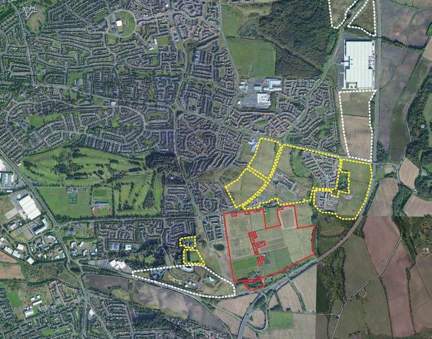
Road network
The site is bound by Lapwing Drive to the north, open farmland to the east,
Masterton Road and the M90 to the south and Skylark Road and Merlin Drive
to the west. Masterton Road is currently subject to a 40mph speed limit.

Connections to surrounding major destinations to both the north and south
of the site are all easily accessible via the strategic road network. The M90
which connects to Edinburgh and Perth can be accessed from the site using
a number of route options.

In addition to the M90, the A985 and A92 are also easily accessible from the
proposed development site; therefore the site benefits from the configuration
of the existing road network to ensure that all surrounding major and local
destinations are easily accessible. Furthermore, the multiple routing options
would ensure that development traffic is effectively dispersed on the local
and strategic road network.

Access Summary
The development is located on the southern edge of Dunfermline. Existing
                                                                                                                                                                             fig. 8:   Location of rail facilities (Extract from WSP Transport Assessment).
conditions for pedestrians provide continuous access from the development
to key destinations including Duloch Park, Masterton Primary School and
other local facilities.

Accessibility for cyclists and pedestrians is considered satisfactory on the
majority of routes, providing access to the surrounding areas of Dunfermline
and local amenities.

There are a number of bus services that operate in the vicinity of the proposed
development. The closest bus stops are located on Lapwing Drive, to the north
of the site. The bus services provide direct access to key local destinations.

The closest rail station to the site is Inverkeithing Rail Station, which provides
a service every 15 minutes into Edinburgh. The station is accessible within a        fig. 7:   Existing Public Transport Services (Extract from WSP Transport Assessment).
15 minute cycle from the Middlebank site via residential and rural roads, and
by off-road paths.

The site is well situated in terms of access to the local and strategic road
network. The M90 is easily accessible from the site via a number of route
options and provides a link to Edinburgh, Glasgow and Perth. There are also
convenient routes from the site to the A92 and A985.

Middlebank, Dunfermline
pg. 7                                                                                                                                                                                                          © Crown copyright, All rights reserved 2013. Licence number 0100031673
                                                                                                                                                                                                                                                                        © Google 2013
2.5 Evolving context
2.5.1 Area of eastern expansion (DEX)
The Dunfermline East Expansion Area (DEX) was identified in the 1994 Fife
Structure Plan as the area best located to accommodate the town’s expansion
needs over the next 20 years. The site extends to approximately 290 hectares.
This planned extension to Dunfermline presently contains over 4500 houses
(around 1000 units still to be completed), a district centre with a range of
shops and commercial uses anchored by a Tesco Superstore, a sports centre
with library, 3 primary schools, a 50 acre public park with an array of sports
facilities, and Fife Leisure Park. The DEX area also contains significant
employment provision (Amazon, etc) and available employment land and is The M90 contains
growth to the east
adjacent to the business park at Pitreavie Castle (to the west).
The expansion has seen the town grow eastward towards the M90 corridor
and is planned to continue until 2022.
House building immediately to the north and north-east of the site is presently
on-going. The context for the site is therefore a changing one and the further
change planned/on-going will reinforce the urban fringe characteristics
surrounding the site.
It is understood that further development interests are being promoted to
the south of Merlin Drive, immediately west of the site, and this would further
add to the context for change and relate well to CALA’s proposals for the
Middlebank land.
The M90 contains
growth to the east
2.5.2 Future growth
Whilst the development of Eastern Dunfermline has been rapid to date, future Duloch House should be
strategic growth opportunities beyond the current allocations in this area Opportunity for future protected by surrounding
housing development to landscape areas
are limited. There remains land to be developed within/adjacent to the DEX
integrate with existing
area but this is reducing and its contribution to housing delivery will begin to areas
diminish in the short/medium term. Growth is constrained by the M90 and
A823(M) which act to define the southern and eastern edge to Dunfermline.
The site area is not identified as green belt and as such presents a logical Development should include landscape proposals
and sustainable area for the future growth of the eastern expansion area, to strengthen the landscape boundary to the south
and east, this will further contain the site and
see figure 9, completing the eastern expansion area up to a robust and well The A823(M)
provide a robust boundary to the M90.
contains growth
defined boundary. The site could provide a reasonable extension of the to the south
existing built-up area and if carried out sensitively provide the opportunity
for additional residential development. Development here could also provide
N Not to scale
the opportunity to strengthen and enhance the landscape boundary and
setting to south east Dunfermline. fig. 9: Middlebank, opportunity for future growth.
Middlebank, Dunfermline
© Crown copyright, All rights reserved 2013. Licence number 0100031673 pg. 8
© Google 20133. Visual appraisal
3.1 Landscape setting Existing development
on Merlin Drive
Existing properties on
private road
Existing development
at Macgregor Road
The landscape setting of south east Dunfermline, including the site area, has Extent of site area
been an area of concern for the Council with regard to further development
in this area.
The LDP Assessment states that “site highly visible in distant views”. It goes
on to state that “more significant impact on landscape setting for Dunfermline
in distant views from major transport routes – important gateway to Fife”,
and concludes that the development would result in “significant landscape
impacts”.
The following section has been included to demonstrate that the approach to
the emerging development proposals for the site will minimise any resultant
landscape impact. The most sensitive parts of the site will be retained free
from development with the remainder being set within an existing/enhanced
landscape context, strengthening the southern boundary to the town.
The landform of the site rises from approximately 55m adjacent to the M90 up
to a high point of 90m, with all of the site area located on a south facing slope.
fig. 10: View to the site from the B980.
In reviewing the visual impact it has been important to consider the landscape
setting as this has a significant impact on how the site is viewed. Figure 10
opposite highlights the site area viewed from the south and illustrates how
important the existing landscape structure and surrounding development
areas are when considering the setting and character of the site.
3.2 Viewpoint selection
Viewpoints have been selected to illustrate both the existing site character
and the surrounding context. These viewpoints have informed a visual analysis
of the potential impacts on the surrounding area. This work has informed the
visual capacity of the site to accommodate development and highlighted any
implications on the proposed layout of the site.
Middlebank, Dunfermline
pg. 9 © Crown copyright, All rights reserved 2013. Licence number 0100031673
© Google 2013Existing properties on
private road
fig. 11: View to the site from Lapwing Drive.
3.2.1 View from Lapwing Drive
This view is taken from Lapwing Drive, Looking south across the site area.
Only the north western part of the site is visible from this location with the
landform concealing views to the southern and eastern parts of the site. This
view illustrates how the landform of the site area slopes down to the south, Viewpoint
allowing views out over the site from this elevated location. location
The plan opposite highlights the viewpoint location and indicatively the parts
of the site visible from this location. Area
visible
N Not to scale
View point location
Middlebank, Dunfermline
© Crown copyright, All rights reserved 2013. Licence number 0100031673 pg. 10
© Google 2013Existing development Existing properties on
on Merlin Drive private road
fig. 12: View to the site from Masterton Road.
3.2.2 View from Masterton Road
This view is taken from Masterton Road looking north east in to the site. From
this view only the south western area of the site is visible, open to the road,
with the landform rising to restrict view to the northern part of the site.
The eastern part of the site area is not visible, with the view to this area
restricted by the landform, hedgerow planting and existing properties along
the private access road that divides the site.
This view illustrates how the landform of the site area rises from the south,
and clearly shows the prominence of the existing housing on Merlin Drive,
visible on the ridge line.
The plan opposite highlights the viewpoint location and indicatively the parts Area
visible
of the site visible from this location.
Viewpoint
location
N Not to scale
View point location
Middlebank, Dunfermline
pg. 11 © Crown copyright, All rights reserved 2013. Licence number 0100031673
© Google 2013Masterton Business Existing properties on Existing properties on
Park Merlin Drive private road
Western site Woodland
boundary forming southern
boundary
fig. 13: View to the site from the M90 travelling north.
3.2.3 View from M90
The view above is taken from the M90 travelling north, just before the A823(M)
junction. This enlarged photograph is representative of the views to the site
from the motorway.
From this view the eastern part of the site is well defined and partly screened,
by mature intervening woodland. The woodland along the southern edge of
the site provides a strong and identifiable boundary to the site.
The private road, private dwellings off the road and surrounding hedgerows
and garden planting are visible. In particular some of the prominent buildings
on the ridge line are visible.
To the east of the private road, no parts of the site are visible from this
viewpoint, concealed by the surrounding woodland.
The fields to the west of the private road and adjacent to the new development
at Merlin Drive are visible. The lower fields in this area are partially screened
by the woodland along the southern edge, however, those on the higher land
adjacent to existing housing are the most prominent. The existing housing at
Merlin Drive is already very prominent in this view as are some of the existing
properties along the ridge line that forms the northern boundary of the site.
N Not to scale
View point location
Middlebank, Dunfermline
© Crown copyright, All rights reserved 2013. Licence number 0100031673 pg. 12
© Google 2013cess road
3.3 Site appraisal Private ac New green space
acting as a buffer
The Middlebank site slopes from a relative high point of some 90 metres to M90 and to
AOD elevation near Lapwing Drive, to a low point in the vicinity of the former protect existing
Scottish SPCA headquarters at approximately 55m AOD (Masterton Road). amenity
A minor road divides the site into two parcels of land (north-south axis),
Prominent area
which are referred to as the western and eastern parts respectively. This road Existing housing of ground in
is owned by No. 10 Middlebank Smallholdings, which is part of CALA’s land prominent on view from M90.
interest. A number of other residential properties are located along the minor ridge line Well contained
Retain as area
road
road, which is accessed via a junction on Masterton Road to the south, and area with limited
of public open
along the north boundary of the site. visibility from M90 Existing
space
ss
The land surrounding the site on its western and northern sides has undergone woodland edge
acce
and continues to undergo a significant transformation as extensive new restricts views
housing areas are completed. House building immediately to the north and to the site
ate
north-east of the site is presently on-going. The context for the site is therefore
Priv
a changing one and the further change planned/on-going will reinforce the
urban fringe characteristics surrounding the site.
The site is south facing and as a consequence of its elevation, parts of the land
benefit from panoramic views to the south, across Inverkeithing and the Forth
road and rail bridges, and to the Pentland Hills. From lower elevation, the site
is more enclosed and a large mature tree belt between the site and the M90 Area with limited
provides some screening to views, both into and from the site. It is the case visibility from M90
Existing
that from some locations surrounding the site the upper parts of the land are
woodland edge
seen, positioned below the skyline of the existing urban edge.
restricts views
The western part of the site is prominent from the M90, when heading in a to the site
northerly direction, as is the recent housing developed on Merlin Drive, off
Masterton Road, which is situated on the crest of the skyline, in a direct line
of sight from the M90. From this location, the eastern part of the site, (to the
east of the existing road which subdivides it), is much less conspicuous and
has a greater capacity for further change as a result.
Dunfermline has already expanded south and east to meet the M90 and
its spurs. The motorway forms a logical and defensible boundary to the
settlement and sensitive development of the Middlebank site could secure a
sizeable area of mixed housing, without impacting unduly on the setting of
the town, or views approaching it from the main route north.
Scale 1:5000 @ A3 Views from M90
N 0m 50m 100m 150m 200m 250m
fig. 14: Visual analysis.
Middlebank, Dunfermline
pg. 13 © Crown copyright, All rights reserved 2013. Licence number 0100031673
© Google 2013From the M90, the mature tree belt along the southern edge of the site
provides a limit to the site and the long term retention and management
of the trees is desirable to maintain a boundary to the settlement. CALA‘s
proposals for the site can deliver this management as the trees lie within the
larger site area.
From other locations in the surrounding area, the eastern more elevated parts
of the site can be seen, but always in the context of a ribbon of detached
houses along the private road on the skyline, which demarcates the northern
boundary. New housing would be seen in the context of this existing skyline
impact and would reinforce an existing influence rather than create something
new. As further housing is completed near Stewart Crescent and on the
allocated commercial/housing site on higher ground across Lapwing Drive at
Dover Heights, this effect will be of less significance.
In response to the visual analysis, CALA has decided not to promote any
housing development on the elevated land to the west of Middlebank
Smallholdings, but instead to offer the protection of this area as shown on
Figure 15 for use as a sizeable area of open space/parkland. The northern part
of this area has relatively level gradients and the potential exists to provide
formal recreation provision, including a sports pitch, which could be accessible
to the new community on the site and to the wider area. Such a facility would
provide a notable public benefit, which is otherwise absent in the surrounding
housing areas due to undulating landform pattern and to address existing
public open space deficiencies in the wider area.
3.4 Visual capacity of the study area
Through the process of review and analysis this study has identified the
parts of the site that have inherent capacity to accommodate development.
Figure 15 opposite identifies the proposed distribution of developable and
undeveloped land uses across the site, having regard to the visual analysis.
The suggested areas suitable for development amount to approximately 22
hectares (within CALA control) within which, in light of the relative levels,
provision of additional public open space, etc. It is proposed that a mix of
housing types and tenure, with a potential capacity of up to 300 units, would
Site area
be provided.
The remainder of the site would be utilised primarily for public open space Suggested development areas
(parkland) and to enhance the landscape setting of the site/development.
Scale 1:5000 @ A3
Suggested areas of open space
N 0m 50m 100m 150m 200m 250m
fig. 15: Indicative development areas.
Middlebank, Dunfermline
© Crown copyright, All rights reserved 2013. Licence number 0100031673 pg. 14
© Google 20134. Site analysis
4.1 Understanding the study area
With regard to the planning context and visual appraisal, described in previous
sections of this study, it has been identified that the site has the capacity to
accommodate some sensitively sited development.
The aim of this section is to identify the sensitivities and opportunities that
exist within the study area and its immediate context, ultimately identifying a
cess road
preferred approach to the location, shape and form of any development to be Private ac
proposed. Analysis of the site has identified the key influences that will determine
the location, shape and character of any future development. The site features
and characteristics will not only direct the shape of any development in this area,
if respected they will allow the site to be developed with a unique character and
‘sense of place’.
4.1.1 Existing land use
The site is currently used for agricultural purposes. Presently, much of the site is
disused and due to constraints (size of the fields and size of modern machinery)
road
is non-viable as an agricultural farm unit.
ss
There have been a number of archaeological surveys to date and no constraints
acce
to development have be recorded.
The Scottish SPCA facility at Middlebank is now no longer operational and forms
ate
a largely Brownfield area within the larger site.
Priv
4.1.2 Ownership
The substantive sections of the site are presently under option to CALA from the
respective landowners. All parties are committed to promoting the development
and therefore ownership is not a constraint to delivery.
4.1.3 Existing properties
A minor private road divides the site into two parcels of land (north-south axis), Site area
which are referred to as the western and eastern parts respectively. This road is
owned by No. 10 Middlebank Smallholdings, which is part of CALA’s land interest. Land outwith control of CALA
The road is single track, with currently only one access point, which is Masterton
Road. ExisƟng properƟes to be retained
A number of other residential properties are located along the minor road, which
is accessed via a junction on Masterton Road to the south, and along the north Land owned by SSPCA
Scale 1:5000 @ A3
boundary of the site.
N 0m 50m 100m 150m 200m 250m Site promoted for development by others
The existing private road will be retained to maintain access to the existing
properties. fig. 16: The site area.
pg. 15 © Crown copyright, All rights reserved 2013. Licence number 0100031673
© Google 2013Scale 1:5000 @ A3
N 0m 50m 100m 150m 200m 250m
fig
fig.
fi
ig 17
17
17:
7:: S
Site aer
ae
errial
e ial phot
hot
oto.
o o
Middlebank, Dunfermline
© Crown copyright, All rights reserved 2013. Licence number 0100031673 pg. 16
© Google 20134.2 Topography
4.2.1 Landform Section line
The site slopes noticeably, from a relative high point of some 90 metres AOD
elevation near Lapwing Drive, to a low point in the vicinity of the former
Scottish SPCA headquarters at approximately 55m AOD (Masterton Road).
To the north of the site area the site levels to a northern plateau, allowing
extensive, panoramic views across the Forth estuary to the Lothians and
Pentlands.
4.2.2 Slopes
Slope analysis, based on Ordnance Survey data, demonstrates that whilst some
parts of the site would require re-profiling, the land area overall is suitable for
development. To the east of the site, adjacent to Duloch House, there are
areas of steeper slopes which would not be suitable for built development.
4.2.3 Aspect
The whole site area is located on a south facing slope which not only provides
great views to the south but also presents a favourable aspect for solar gain.
fig. 18: Slope analysis. fig. 19: Middlebank, site landform.
fig. 20: Section through the existing site (section line on fig 18 above).
Middlebank, Dunfermline
pg. 17 © Crown copyright, All rights reserved 2013. Licence number 0100031673
© Google 2013fig. 21: View south from western edge of study area.
4.3 Views from the site
The site at Middlebank offers the opportunity to experience a number of long
range views south to the River Forth, The Forth Bridges, Edinburgh and the
Lothians. These views can be experienced from most parts of the site and
are best experienced from the areas of higher ground to the north of the site.
The site layout should be developed in such a way so as to retain the views
where possible and provide access to areas of open space where views can
be experienced.
fig. 22: View south from the private road along the northern edge of the study area. fig. 23: The private road aligns to key views south.
Middlebank, Dunfermline
© Crown copyright, All rights reserved 2013. Licence number 0100031673 pg. 18
© Google 2013Hedgerow field boundary within the site. Southern boundary to Masterton Road.
N Not to scale
fig. 24: Landscape structure.
4.4 Landscape structure
Any development proposals at Middlebank should carefully consider the Private access road. Western boundary to existing housing.
landscape quality and pattern that make the site distinctive and which
landscape elements should be considered as features within any site layout.
The Middlebank site has a regular pattern of small fields well defined by a mix
of hedgerows and stonewalls. The private access road and existing properties
are defined by hedgerows.
The southern and eastern boundaries are well defined by mature woodland
areas which restrict views into these parts of the site from surrounding roads.
The western boundary is defined by a stone wall and back fences of adjacent
properties to the west.
The northern site boundary is well defined by a combination of stone walls
and hedges surrounding the existing properties. This edge is further defined
by some larger trees and the buildings located along the road.
Western site boundary to south adjacent to Masterton Road. Existing private road along the northern boundary.
Middlebank, Dunfermline
pg. 19 © Crown copyright, All rights reserved 2013. Licence number 0100031673
© Google 20134.5 Access Proposed pedestrian connections
A comprehensive network of pedestrian facilities is provided throughout the
established residential area which is located within the immediate vicinity of Bus
Extract from WSP Transport Assessment. stop
the site.
A comprehensive network of pedestrian and cycle facilities will be provided
throughout the development to encourage local trips to be made on foot or Access onto Lapwing Drive is provided from an existing path and road
by cycle. A number of pedestrian / cycle accesses will be formed to ensure network within the site. This provides access to the nearest bus stops which Bus
are located to the north along Lapwing Drive. stop
that the internal network is well connected to the external facilities.
It is proposed to design the internal development layout in accordance with To the south of the site on Masterton Road footpath provision is limited.
400m from
Designing Streets which will result in a network of streets which encourages As such, it would be proposed to provide a new shared pedestrian / cycle bus stop
low vehicle speeds providing an attractive environment for pedestrian and path along the southern site boundary on Masterton Road on land within the
cyclist movement with the opportunity to introduce areas of public realm. proposed site boundary.
The road network within Dunfermline is generally well lit and residential in 400m from
Local amenities such as Masterton Primary School and Duloch Park District bus stop
Centre are located within a convenient walk or cycle of the site providing nature with a minimum of one footway provided adjacent to the carriageway.
opportunity for travel to and from the site on foot and by cycle. In addition, These are supplemented by additional footpaths and a network of Core Paths
public transport facilities such as existing bus stops are located within an and cycle routes to provide a comprehensive network facilitating convenient
acceptable walk of the site. It is intended that the site’s accessibility will travel on foot and by bicycle to key destinations in and around Dunfermline.
800m from
encourage residents to travel to and from the site using sustainable modes It is proposed to provide comprehensive pedestrian accesses into the site bus stop
of travel. to ensure convenient connection is provided between the internal and
It is considered that the range of proposed accesses will ensure that the established external pedestrian networks. Pedestrian access will be provided
development is legible by all modes of transport and that it will provide into the site from an existing link taken from Lapwing Drive and a new access
taken at the north eastern corner of the site, to ensure convenient access to N Not to scale
opportunity for residents to access the site by sustainable modes of travel.
the bus stops which are located immediately to the north of the site. fig. 25: Pedestrian connections.
Public transport
Frequent bus services currently operate in the vicinity of the site. Services
Proposed vehicle connections
currently operate on Lapwing Drive connecting the site with a number of Vehicular access will be taken from two new access junctions located on Site area
destinations including central Dunfermline. Approximately 40% of the Masterton Road on the southern site boundary on land under the control of
development site is within 400m of the existing bus stops on Lapwing Drive, the site promoter. It would be proposed to construct two priority junctions on ExisƟng Core Path
with the remainder of the site being between 600 and 800m. This can be Masterton Road to link with the internal road network, which described will be
seen in figure 25. designed in accordance with Designing Streets. ExisƟng NaƟonal Cycle Route
Access from Lapwing Drive to the north would be for pedestrians and cyclists
only. LocaƟon of exisƟng Bus Stop
It is proposed to design the internal development layout in accordance with
Designing Streets which will result in a network of streets which encourages Alignment of exisƟng access road
low vehicle speeds providing an attractive environment for pedestrian and
cyclist movement with the opportunity to introduce areas of public realm. Proposed vehicle connecƟon point
Proposed pedestrian connecƟon point
Middlebank, Dunfermline
© Crown copyright, All rights reserved 2013. Licence number 0100031673 pg. 20
© Google 20137.
6 4.
5.
Viewpoint 1 - looking west from private access road.
1.
3. 2.
N Not to scale
fig. 26: Site viewpoints.
4.6 Site viewpoints
The photos opposite are included to illustrate some of the key aspects of the Viewpoint 2 - Masterton Road, existing hedge and mature woodland defining southern boundary. Viewpoint 3 - Private access road and existing propoerties defined by hedgerows.
site area and key site features.
Viewpoint 4 - Private access road along the northern boundary of the site.
Middlebank, Dunfermline
pg. 21 © Crown copyright, All rights reserved 2013. Licence number 0100031673
© Google 2013Viewpoint 5 - Looking west to existing housing at Merlin Dive.
Viewpoint 6 - View west along Lapwing Drive and existing housing along western boundary.
Viewpoint 7 - View east along Lapwing Drive.
Middlebank, Dunfermline
© Crown copyright, All rights reserved 2013. Licence number 0100031673 pg. 22
© Google 20134.7 Approach to development
The approach to guide development at Middlebank has been driven by the
analysis and appreciation of the site area. The desire to create a high quality
residential development that aims to respect and enhance the setting and
Ridgeline
surrounding environment. The approach to development is based on the
following key principles:
• The visual appraisal has identified the extents of the site’s inherent
capacity to accommodate residential development and these should be
respected in any layout.
• An area of open space must be created in the north west of the site area. Prominent area
• Areas of open space and woodland planting should be located to of ground in view
strengthen the eastern and southern boundaries. from M90. Retain
as area of public
• Vehicle access should be gained from at least two locations on Masterton
open space
Road.
• Pedestrian connections must be provided to Lapwing Drive in the north
west and Masterton Road (NCR1) to the south west.
• An interconnected network of pedestrian routes should connect all parts Prominent existing
of the site and explore connections to neighbouring residential areas. housing edge
• The setting and access of existing properties must be maintained and
sensitively respected.
• The layout should retain existing field boundaries where possible.
• The layout should seek to maximise the southerly aspect and views from
the site.
• The layout should be designed to allow adjacent landowners to stitch into Site area
the network of streets and spaces.
• Potential for a vehicle connection to Masterton Road to the west should Suggested development areas
be considered and discussed with neighbouring developers.
Importantly all aspects of the development must seek to minimise the visual Suggested areas of open space
impact upon the study area, be in keeping with the character of the area and
maintain the ‘sense of place’. Access points to the site
Through analysis of the site there are considered to be no physical constraints
ExisƟng field boundaries
which would preclude the development at Middlebank within the development
areas identified.
Scale 1:5000 @ A3
Strategic landscape structure
Access was a matter of concern raised previously but this is now fully
N 0m 50m 100m 150m 200m 250m
addressed in the amended proposals and in the Transport Assessment.
fig. 27: Site analysis.
Middlebank, Dunfermline
pg. 23 © Crown copyright, All rights reserved 2013. Licence number 0100031673
© Google 20134.8 Appraisal + concept
The site lies at the southern edge of the East Dunfermline
expansion area and its new city districts. Currently the
land within the site is a combination of isolated residential
and farm buildings, open grassland used for grazing with
defining internal hedges and mature woodland to the east
and south. A prominent northern plateau dominates visually,
supported by open fields sloping to the south and south-
east, allowing extensive, panoramic views across the Forth
estuary to the Lothians and Pentlands.
The site is in an important strategic location, straddling
an important threshold for the City of Dunfermline and
its eastern expansion area, in particular. This southern
threshold, is defined by the prominent skyline and associated
ridge line, which had been the natural boundary of the city.
Recent development however has now broken through this
threshold, and the proposed site offers a real prospect of
protecting this important edge of the city, by responding
in a positive and sensitive way, creating a vibrant new
developed frontage for the city, one that can compliment
and ‘ bookend’ the other development sites in the area,
notably, the long term build-out at Masterton Park.
Key features of the site are illustrated and described on the
diagram opposite. Strong landform and orientation of the
site features naturally divide into characteristic parcels. This
diagram can also be read as the basis of any development
concept.
This linear orthogonal grid will offer the opportunity to
strengthen the already well wooded edge of the site to
the east and south, allowing the development framework
to be permeated by a new hedge and street tree matrix,
defining new plot zones. The natural orientation of this grid
(notionally indicated here) can do a number of important
jobs. First, it can allow woodland to sit at an appropriate
angle to the primary views into the site, partially screening
and absorbing potential development, whilst at the same Scale 1:5000 @ A3
time, and second, allowing views out from the site and its
N 0m 50m 100m 150m 200m 250m
high quality housing, over the exceptional landscape to the
fig.
fig
g 28
28:
8::
8 Site
Sit
S it
ite
tte
e ap
app
appprais
r all a
rai
ra and
nd conce
conc
o ept
once pt.
pt.
south.
Middlebank, Dunfermline
© Crown copyright, All rights reserved 2013. Licence number 0100031673 pg. 24
© Google 20135. Development vision
5.1 Strategy for development 5.2 Development Framework
FIFEplan and the Fife Urban Design Guide recognise that development The Development Framework shown opposite illustrates how the concept for
can bring some benefits through enhancing landscape and creating future the site could be realised through site wide design principles. It sets out a
landscapes of quality and character in the provision of new green infrastructure. spatial framework for the way in which the site could be developed. It is used
In line with this principle, the following sections will explain further how the to describe and explain the integrated land-use, landscape and transport
concept for development at Middlebank can be sensitively integrated within proposals.
the urban pattern and landscape setting and can bring a number of benefits Following principles set out in the Fife Council Urban Design Guide and best
to the wider area that comply with the aims of the Local Development Plan. practice ‘Masterplanning Guidance’, it establishes a flexible structure for
The strategy for development at Middlebank, illustrated opposite on the development which will allow more detailed proposals to come forward in
Adopted Local Plan base, is to provide a comprehensive and well planned due course.
expansion to the south of Dunfermline that fits the existing landscape The Development Framework uses the natural characteristics of the site and
structure. its context to order the nature of any development and distribution of land
The site should be developed in a positive manner to complete the southern uses, streets and open spaces. The orthogonal nature of the site features
edge of Dunfermline, providing future growth of DEX and ensuring that a already respects the land-form and their relationship to the topography, the
strong, well defined southern boundary is created. The framework should ridge line and existing wooded edges.
respect and strengthen the existing landscape structure to create an attractive
environment and mitigate against any environmental and visual impacts. 5.2.1 Development capacity
The site should be designed to integrate with the existing development as Of the total site area of 41ha the areas suitable for development identified on
best possible through built form, access and in particular the landscape the plan opposite, Figure 30 measure approximately 22ha.
N Not to scale
framework. Through testing it is considered that the layout has capacity for up to 300
fig. 29: Illustration of strategy for development on Local Plan base. homes. The residential density would be lower as a result of the topography
The following section will demonstrate how the strategy for development
of Middlebank can be carried out to create an attractive and importantly and the desire to respect the landscape setting and location of the existing
deliverable new part of Dunfermline. properties. Some areas of higher density could be incorporated within the
layout to add variety in the development mix and aid the development of
character.
The final mix would include affordable housing in line with the requirements
of FIFEplan.
Middlebank, Dunfermline
pg. 25 © Crown copyright, All rights reserved 2013. Licence number 0100031673
© Google 2013Site area
Proposed development areas
ExisƟng properƟes within study area
Proposed areas of open space
Suggested areas for SUDs
ConnecƟons to exisƟng road network
IndicaƟve street network
ExisƟng private road within site area
IndicaƟve pedestrian/cycle connecƟons within the site
PotenƟal pedestrian/cycle connecƟons
ExisƟng core path connecƟons outwith the site
ExisƟng NaƟonal Cycle Route outwith the site
Scale 1:5000 @ A3
Note: Proposals not within land controlled by CALA are shown for aspiraƟonal
masterplanning purposes. N 0m 50m 100m 150m 200m 250m
fig. 30: Middlebank Development Framework.
Middlebank, Dunfermline
© Crown copyright, All rights reserved 2013. Licence number 0100031673 pg. 26
© Google 20135.2.2 Landscape framework Open space provision
The general approach towards the landscape structure is based upon Guidance given in the Adopted LP requires the provision of 60m2 of open
mitigating the visual impact of the primary views to the site. This has helped space per dwelling. Using the maximum site capacity of 300 residential units,
inform the location of the key features and areas of open space. The function an area of approximately 18,000sqm (1.8ha) would be required.
and purpose of these aspects is described further below. The landscape framework shown opposite provides approximately 10.7ha
Key landscape elements of open space within land controlled by CALA, exceeding the open space
Field boundaries requirements of the Council. All of the open space will be designed to be
easily accessible and provide a variety of functions for residents.
Field boundaries are characteristic of the site area and should be retained
where possible and integrated into the streets and spaces. The layout should In addition to the core areas of open space, areas are identified for SUDs
incorporate these features to give a sense of location and orientation. which if implemented sensitively, could also count towards provision of green
links and semi-natural space.
The matrix of intervening field boundaries if retained and enhanced will act to
further mitigate any significant visual effects. SUDs
Formal parkland (7.3ha) The treatment of surface water run off generated as a result of the proposed
An area of open space is proposed to the north west of the site, in the most development will be managed via the use of SUDs. The SUDs facilities will offer
visible part of the site. This space will provide a resource for the surrounding an important resource for biodiversity and sustainable treatment of surface
community and act to minimise the visual impact of the new development on water run-off. The SUDs facilities should be integrated within the areas of
views from the south. open space in which they are identified and be designed to feel part of the
space. They may need to be fenced as part of the Scottish Water design
This space will be the main entrance space from the north for pedestrians.
requirements and if so should be done in a way in which they still contribute
It should be designed to incorporate path links and allow users to enjoy the
to the design of the park, incorporating the SUDs as ‘natural’ features within
views to the south. It should be designed as a more formal parkland space,
the layout. N Not to scale
providing areas for equipped play, sports and recreation.
fig. 31: Middlebank - Location of SUDs features.
Informal parkland edge (3.4ha within CALA site area)
A significant area of open space should be provided along the southern
and eastern edges of the site to create a robust defensible boundary and
Site area
enhance the landscape setting. This space should be designed as an informal
parkland and include new woodland planting to reinforce the existing areas of Proposed development areas
woodland that currently define this edge.
ExisƟng woodland areas
The space should incorporate SUDs, areas for informal and possibly formal
recreation, and appropriate planting to provide an attractive outlook for
ExisƟng field boundaries
adjacent properties.
Proposed area of formal parkland
Proposed area of informal parkland
Proposed entrance spaces/nodal spaces within development
Suggested locaƟons for SUDs
Middlebank, Dunfermline
pg. 27 © Crown copyright, All rights reserved 2013. Licence number 0100031673
© Google 2013You can also read