PENN HOUSE FEBRUARY 2021 - Understanding Historic Parks and Gardens in Buckinghamshire - Buckinghamshire Gardens Trust
←
→
Page content transcription
If your browser does not render page correctly, please read the page content below
Understanding Historic Parks and
       Gardens in Buckinghamshire
The Buckinghamshire Gardens Trust Research & Recording Project

                 PENN HOUSE
                  FEBRUARY 2021

                                        Roland
                                        Callingham
                                        Foundation
Bucks Gardens Trust, Site Dossier: Penn House, Chiltern Area February 2021

    HISTORIC SITE BOUNDARY

                                    2
Bucks Gardens Trust, Site Dossier: Penn House, Chiltern Area February 2021

                                    3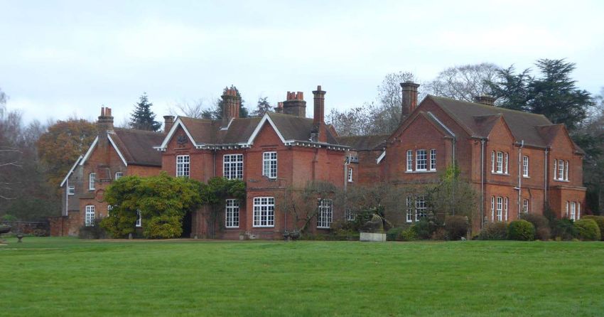
Bucks Gardens Trust, Site Dossier: Penn House, Chiltern Area February 2021

INTRODUCTION

Background to the Project
This site dossier has been prepared as part of The Buckinghamshire Gardens Trust (BGT) Research
and Recording Project, begun in 2014. This site is one of several hundred designed landscapes
county‐wide identified by Bucks County Council (BCC) in 1998 (including Milton Keynes District) as
potentially retaining evidence of historic interest, as part of the Historic Parks and Gardens Register
Review project carried out for English Heritage (now Historic England) (BCC Report No. 508). The list
is not definitive and further parks and gardens may be identified as research continues or further
information comes to light.

Content
BGT has taken the Register Review list as a sound basis from which to select sites for appraisal as
part of its Research and Recording Project for designed landscapes in the historic county of Bucks
(pre‐1974 boundaries). For each site a dossier is prepared by volunteers trained by BGT in appraising
designed landscapes.

Each dossier includes the following for the site:
 • A site boundary mapped on the current Ordnance Survey to indicate the extent of the main part
    of the surviving designed landscape, also a current aerial photograph.
 • A statement of historic significance based on the four Interests outlined in the National Planning
    Policy Framework and including an overview.
 • A description, derived from documentary research and site visits, based on the format of
    Historic England’s Register of Parks & Gardens of special historic interest 2nd edn.
 • A map showing principal views and features.

The area within the site boundary represents the significant coherent remains of the designed
landscape. It does not necessarily include all surviving elements of the historical landscape design,
which may be fragmented. It takes no account of current ownership.

NOTE: Sites are not open to the public unless advertised elsewhere.

Supporters and Acknowledgements
The project was funded by BGT, with significant grants from the Finnis Scott Foundation, the
Roland Callingham Foundation, BCC (since April 2020 part of Buckinghamshire Council) and
various private donors. Buckinghamshire Council also provided significant funding, and help in
kind including current and historic mapping and access to the Historic Environment Record. The
project is supported by The Gardens Trust.

The Trust thanks the volunteers and owners who have participated in this project and given so much
time and effort to complete this challenging and rewarding task.
Further information is available from: www.bucksgardenstrust.org.uk

                                                        4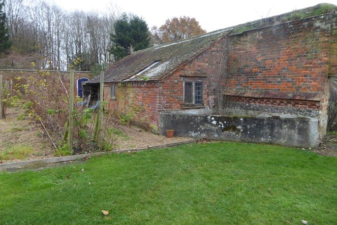
Bucks Gardens Trust, Site Dossier: Penn House, Chiltern Area February 2021

SITE NAME: PENN HOUSE                                          HER No. 001692000

COUNTY: BUCKINGHAMSHIRE                                        GRID REF: SU 924 949
PARISH: PENN

STATEMENT OF SIGNIFICANCE

Overview

Penn House is a country house of the Curzon and Howe families with a park, gardens and pleasure
grounds in which a small garden surrounding the house in the 1760s was extended successively in
the late C18/early C19, and late C19, with minor additions in the early-mid-C20. The grounds survive
intact with much mature ornamental planting and are a good example of a Chiltern estate.

Archaeological interest

The site has the potential for evidence associated with medieval agricultural and woodland uses,
particularly relating to the surviving ancient trees, banks, routes, boundaries, buildings and the tile
industry. It has potential for the early house (c.C16 and possibly earlier) and associated features, and
for former features of the designed landscape from the C18 onwards, e.g. buildings, paths, beds,
terraces, boundaries, particularly for the kitchen garden, and lost drives and rides.

Architectural interest

The house, stable block, service structures, lodges and kitchen garden walls form a group of
architectural note, built incrementally between the mid-C18 and early C20. Garden structures of this
period are of considerable importance as part of the landscape design, particularly the group of
Pope’s obelisk and urns which were brought from his garden in Twickenham c1830 and which now
stand here. The late C19 work on the house and stables/ coach house was carried out by the
architect David Brandon.

Artistic interest

The site is a typical Chiltern country estate comprising park, garden and pleasure grounds,
developed over c.200 years, to reach its zenith in the mid-C20. The layout remains intact, focussed
on the house, formal gardens to the east and kitchen garden to the north, with many mature trees,
including Wellingtonias, and fine avenues and belts along the drives. Pope’s Obelisk and Urns are the
most significant ornamental feature, terminating an axis from the entrance of the house. The long
south drive is of particular note with a winding course from the early C20 lodge up the hillside to the
plateau, taking in extensive views of the steep hillsides and estate land. Other estate structures
particularly the kitchen garden walls and cottages form incidents along the drives.

Historic interest

The estate has been associated with the notable Curzon and Howe families for several centuries, and
a related archive survives (Buckinghamshire Archive). The early C19 connection of the Howe family
with Pope’s renowned Villa in Twickenham is of significance for the destruction of the villa by
Baroness Howe, and the removal of one of the most important elements of his influential garden,
commemorating his mother, that now adorn the grounds at Penn.

                                                        5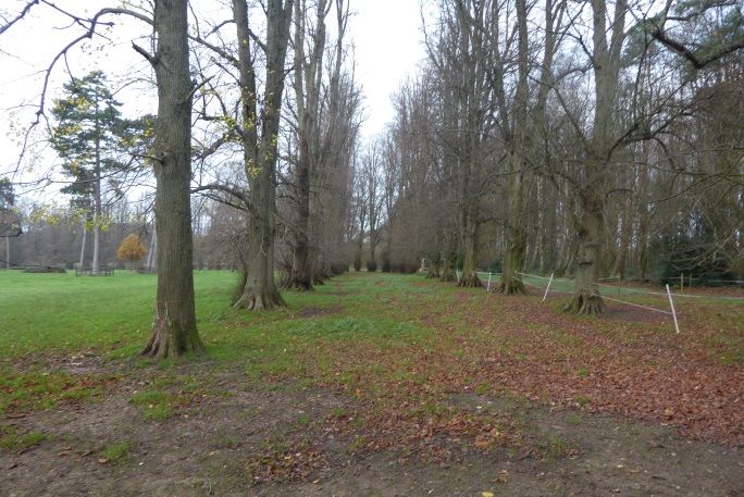
Bucks Gardens Trust, Site Dossier: Penn House, Chiltern Area February 2021

HISTORIC DEVELOPMENT

The history of the landscape begins with the formerly extensive Wycombe Heath, originally part of
lands belonging to Alfred the Great, covering originally nearly 4000 acres (about 4 miles long and 2
wide), largely wooded to the south of what is now the A404 Wycombe-Amersham road, and more
open to the north. Its boundaries defined a ‘chase’ rather than a heath, which was maintained in
Saxon and early Norman times for the benefit of the citizens of London. This was confirmed by a
charter of Henry I between 1130 and 1133 (Green 2018). The Parish of Penn was held by the Turville
family in the C12 and was later attached to the Honour of Leicester and afterwards passed to the
Duchy of Lancaster. In 1222 the manor was divided: the part called Penn Manor was held by James
Penn (VCH). Penn house may have originated c1285 as Pennbury Manor, an incursion on the Heath
by the Penn family (Green 2000).

The tile industry centred on Penn and Tylers Green 2.2 km (1.4 miles) south west of the house was
‘the most extensive, successful and well-organized commercial tile workshops in medieval England’.
It provided vast quantities of floor and roof tiles for royal, monastic and high status sites across the
south east of England (Green 2005). Opposite the northern entrance to Penn House is Pennstreet
Farm, noted as a Brick and Tile works in the late C19 (OS). Extractive workings were across the road
(HER 0835500000 – MBC 2357).They are partly located within the historic site boundary as
delineated here.

A charter of c.1400 redefined the boundaries of the heath as a consequence of the incursions
(Green, 2013). Grants of land were made to David and Sybil Penn by Henry VIII and Edward VI (Sybil
had been nursemaid to the infant Edward). A house was probably built at this time (a date stone for
1536 survives at the house). Roger Penn (Sheriff of Buckinghamshire in 1706) died unmarried in
1731. With the marriage of his sister, the manor passed to the Curzons of Kedleston, Derbyshire
(VCH).

The house was remodelled c.1760 and much was demolished (Pevsner and Williamson). In 1787, the
Hon. Penn Assheton Curzon married Sophia Charlotte, a daughter of Admiral Lord Howe, who later
became Baroness Howe of Langar in Nottingham in her own right (Jenkins). The magnificent Gopsall
Hall near Twycross, Leicestershire was inherited from Charles Jennens (a great uncle) in 1773. Penn
House was thus the second home for this branch of the Curzon family until the sale of Gopsall Hall in
1918. (The hall and gardens at Gopsall became Crown Property in the early 1930’s and it was
demolished in 1951. https://en.wikipedia.org /wiki/gopsall and
http://congerstonevillage.co.uk/gopsall-hall/)

The nucleus of the present layout was established around the house by 1761 (Rocque South Bucks
map). ‘Pen House’ at this time was enclosed by small formal garden except on the west, entrance
side which faced the drive from the north off Penn Street. It was set adjacent to Wycombe Heath in
a typical Chiltern landscape, of small fields and woodland including Penn Wood, on a plateau above
a scarp to the west and south-west.

Penn Assheton and Sophia’s son Richard William Penn Curzon (1796-1870), created Earl Howe, later
took the surname Curzon-Howe. By 1812 (Ordnance Survey Draft) ‘Pen Ho.’ was a small estate with

                                                        6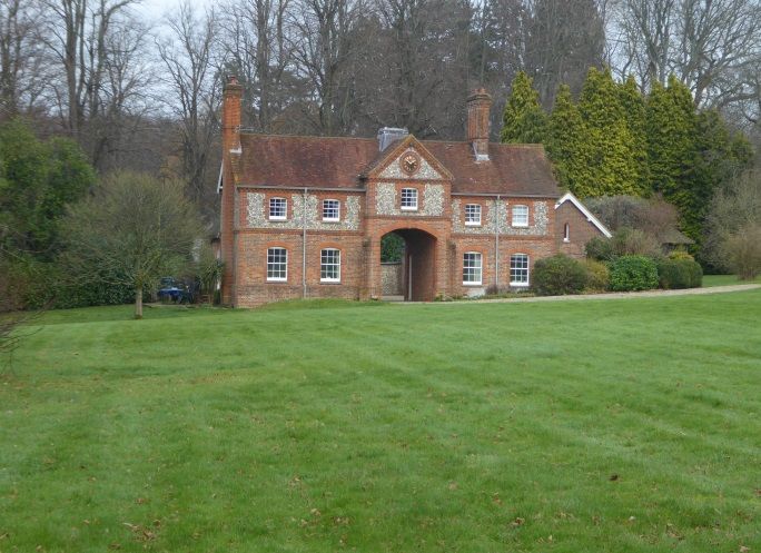
Bucks Gardens Trust, Site Dossier: Penn House, Chiltern Area February 2021

the current north drive, and a walled enclosure on the site of the current kitchen garden, which was
somewhat smaller than the present enclosure.

The grounds were developed in the late C18/early C19 so that by 1824 (Bryant) the house stood at
the north-west corner of a small, roughly square estate which corresponds to what is today The Big
Park. This was bounded to the west by the north drive which had been considerably extended south
of the house to the public road now called Gravelly Way.

A cedar of Lebanon was planted at Penn House to celebrate the visit of William IV and Queen
Adelaide in the early 1830s, Earl Howe being chamberlain to the Queen.
(www.pennhouse.org.uk/house/house and Jenkins)

By 1840 (Tithe) the small Estate noted by Bryant was scheduled as divided into five parcels fringed
on its south and east sides by a belt of trees. Three parcels had ‘warren’ in their names. A fourth was
called ‘Dove House Mead’. Along with the walled garden and orchard to the north of the house
stretching out towards the approach from Penn Street to the north (1812 OS Draft) and a ‘melon
ground and garden’ to the west, these with the warrens were the only parcels of land closely
recorded as associated with the house, totalling just over 30 acres (12ha). The house then had a
large block on the north-east at right angles to the current alignment of the house. The main
approach from the north swept round the outside of the walled garden north of the house, and
terminated in front of the coach house and stables to the south. Three small areas of water included
one within the garden east of the house, another just east of the garden, and a third in an enclosure
east of what was later mapped as a farm yard (Tithe).

By the 1870s (OS) little had altered in the grounds, but Garden Cottage had been built in Old English
style alongside the north drive near the kitchen garden. The main north-east part of Penn House had
been demolished and the surviving section was extremely modest. It was located between a service
yard and a kitchen garden to the north and a stable yard with a carriage circle to the south (AR 94/80
612). The east front of the house overlooked a small formal garden which led east to a larger garden
with an oval pool on the axis. This garden had been extended to take in the second pond and had
subsidiary buildings on its northern side. The inner end of the drive had been redirected towards the
west front of the house where a roughly circular drive was laid out. The earlier connection with the
coach house and stables was blocked with tree planting and a drive looped round the south end of
the stables to the stable yard (AR 94/80 612). The west elevation of the house appears to have been
haphazard and perfunctory (AR 94/80 612). The entrance to the kitchen yard and services - from the
north - left the principal approach from Penn Street and ran between a walled garden and an
orchard. A track crossed the square park from the south-east towards the coach yard and turned
westwards to meet the northern approach (OS 1874-77).

Further plans (AR 94/80 612) demonstrate the considerable interest by the 3rd Earl (d.1900) shown
at the time in the urgent improvement of Penn House. Early in 1878 the range of farm buildings and
a farm yard on the east side of the coach yard had been swept away by the time of a sketch in April
for the improvement of foul drainage. Plans were presented by David Brandon (1813 -1897) c.1880
for a southern extension to provide new bedrooms over a library and a new drawing room: the first
designs were more ornate and were accompanied by full scale details (AR 94/80 612). They were not

                                                       7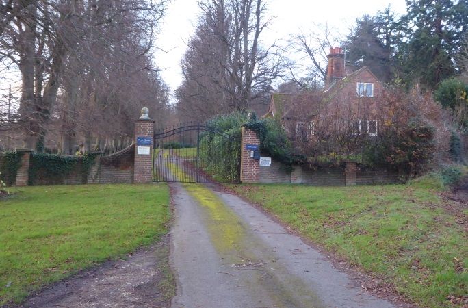
Bucks Gardens Trust, Site Dossier: Penn House, Chiltern Area February 2021

proceeded with and plainer designs were executed. The resulting extension gave the surviving house
south-facing rooms for the first time. The clearance of the old stable yard, stables and coach house,
farm buildings and yard and the extension of the gardens around the new rooms with a wider
perimeter gave the occupants of the house fresh vistas to enjoy (AR 94/80 612; OS 1897).

A replacement stables and coach house was erected west of the house to designs by Brandon. This
was not completed as originally designed as enclosing a yard (AR 94/80 612). A further building
campaign by Brandon saw the erection of a new west frontage which was complete by 1895 (photo
in possession of Earl Howe) and the erection of the Dower House and accommodation for staff on
the north side of the yard. A radical scheme by Sir Reginald Blomfield (1856-1942) for the
‘remodelling’ of Penn House in Jacobean Style (RIBA, Keil p.49), was presumably made for the house
to be ready for the role as the principal family residence after the sale of Gopsall but was not
executed.

In the 20 years between 1877 and 1897 (OS) the north park had been laid out in several sections
between Charcoal Grove and Penn Street. Land between the north drive and Penn Street was laid
out, with a new lodge, Laurel Lodge on the main road, linking a short straight avenue with Garden
Cottage where it joined the north drive. The Big Park was extended with a smaller square area
south-west of the house. The north end of the south drive was realigned, probably as part of the
alterations described above (Earl Howe, pers. comm.) when part of The Big Park was enclosed into
the pleasure grounds. The garden east of the house was laid out in its present form.

Around 1830 an obelisk and two urns from the Twickenham garden of the famous early C18 writer
Alexander Pope, commemorating his mother, were installed at Gopsall (Keil p.10). Pope had used
the obelisk as one of the focal points of his garden which was reached via his renowned grotto under
the road. Shortly before they were moved, in 1826, they had been measured and sketched by
Buckler. They were owned by Baroness Howe, who had demolished Pope’s house in 1807, as she
was inconvenienced by persistent visitors anxious to see the garden and grotto. She earned the
name the ‘Queen of the Goths’ thereby (Batey). The obelisk, urns and seat were moved to Penn
House probably in the early C20. (Earl Howe, pers. comm.)

The matching porte cochére on the west frontage followed in 1929
(Britainfromabove.org.uk/image/EPW031201 shows the work in progress). The ha-ha evident in the
same aerial photo was later removed as part of the extension of the pleasure grounds to the south-
east.

The house was rented by two schools during and after World War II: firstly by Forres School from
Swanage, Dorset ) 1940-45; and subsequently by Emsworth House School (Hampshire) until 1955
(Earl Howe pers. comm.) The latter school’s buildings had been requisitioned by the Admiralty
(://emsworthmuseum.org.uk/emcms/exhibits/show/history-of-emsworth/emsworth-timeline).

Frederick, 7th Earl Howe (1951-) has since his succession in 1986 carried out considerable works in
the site and the wider estate, which had fallen in poor condition. A thicket of planting was cleared at
the east end of the main axis of the formal part of the garden. This was earlier the location of a
square sweet pea garden with rustic thatched summer house instituted by the 5th Earl to provide his

                                                       8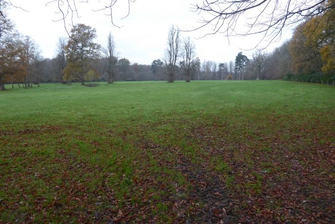
Bucks Gardens Trust, Site Dossier: Penn House, Chiltern Area February 2021

favourite flowers for his London house (Earl Howe, pers. comm.).The square was set within a hedge
with the summer house located in an apsidal extension on the east (outer) side (1947 RAF aerial
photo (‘AP’)).

The House and Estate remain in private ownership with various lodges and the stables (now called
‘Grove House’) occupied separately.

SITE DESCRIPTION

LOCATION, AREA, BOUNDARIES, LANDFORM AND SETTING

Penn House lies at the heart of the Chilterns, 2km (1.25 miles) north-east of Penn, 1km (0.6 miles)
west of Winchmore Hill, and 6km (3.75 miles) north-east and 5.2km (3.25 miles) north-north-west of
the historic centres of Wycombe and Beaconsfield respectively. The 50 ha. site lies within the
country road network provided by the Penn Street/Winchmore Hill road to the north, Horsemoor
Lane to the east, Penn Bottom to the south and the Penn Bottom/Penn Street road to the west. The
countryside is rolling and well-wooded. The ground is heavy clay with chalk and flints. The house,
Penn Street and Winchmore Hill are located on ‘Reading Beds’ which usefully provided water for the
early surrounding settlements, acting as saucers where water can accumulate (Green 2013). The site
lies in a secluded patchwork of mature woodland, copses, parkland and fields on relatively level high
ground above valleys leading down to the valley of the River Wye to the south. Because of the
wealth of mature woodland, there are no long views. Boundaries are generally of post and wire.

ENTRANCES AND APPROACHES

The main approach is from the north. The main entrance lies 380m north of the house, 270m south-
east of the south end of Penn Street off the road to Winchmore Hill where the common widens out
into a triangular space. From the simple gateway flanked by a white-painted wooden gate, adjacent
to two C17 pairs of semi-detached cottages, Lodge Cottages, Elm Cottage/Gate Cottage (listed Grade
II) and a pair of C20 estate houses, the sinuous north drive leads through the park to the house. The
drive is flanked on the west side by The Copse and on the east by a small area of parkland with
stands of mature trees. Approaching a lodge of C19 date in cottage orné style (Garden Cottage) it
passes the south-west end of a short avenue recently replanted with oaks arriving from Laurel Lodge
standing 240m north east on the Penn Street/Winchmore Hill road.

A spur south off the north drive forms the service drive, leading from Garden Cottage directly to a
yard against the east side of the house. The entrance to the yard is flanked by two-storey buildings:
to the west is a service building with prominent dormer gables: eastwards is the Dower House, a late
C19 former stable block (listed Grade II); the white-painted cupola was rescued from the demolition
of the earlier coach house and stable yard (Earl Howe pers. comm.) This yard has three decorative
exits through its boundary walls, all by means of segmental brick arches under tall triangular brick
pediments. One leads along the east side of the house to the formal garden while another exits
northwards into the walled garden. The third gives access eastwards to the front door of the Dower
House.
The main north drive continues south-west for c.100m past the north side of the walled garden and
turns south along its west side for 70m past a line of mature horse chestnuts. It enters an oval

                                                       9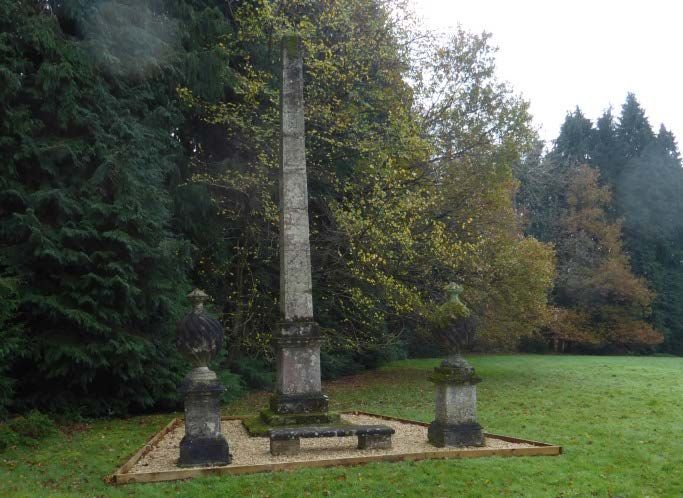
Bucks Gardens Trust, Site Dossier: Penn House, Chiltern Area February 2021

gravelled carriage sweep in front of the entrance (west) front of the house. Formerly a small circular
pond occupied the centre, present in 1956 (Keil p.28 and various AP’s (HER)).

The south drive enters the park 1.1km south-east of the house near the south end of Horsemoor
Lane. The South Lodge was probably erected after World War I (OS 1925) by the 4th Earl (d.1929), an
improvement most likely in response to the convenience of the new Beaconsfield station opened in
1906. The decorative metal gates supported by late square brick piers with ball finials followed more
recently (Earl Howe, pers. comm.). Alterations by the 5th Earl as a noted racing driver were probably
limited to surfacing the drive in tarmac and banking the main corners to allow motor travel at speed
(Earl Howe, pers. comm.). South Lodge, to the east inside the gate, is a neat brick cottage with a
substantial central chimney stack. The winding approach climbs steadily, first through a 165m long
lime avenue and then through woodland. Nearer the house it leaves the woodland and enters
another mature lime avenue, 200m long, on the south west side of The Big Park. This second avenue
was newly planted after World War II (1947 RAF AP). It enters the pleasure grounds through metal
gates with brick piers c.140m south-west of the house. It continues north-west to join the oval
carriage sweep in front of the house.

A disused drive from the valley to the south-west approaches along the line of a public footpath.
From the entrance, off Gravelly Way lane 500m south-west of the house, it is framed by a lime
avenue then enters Pennhouse Grove curving up the hill, in part lined by rhododendron
understorey, to the south end of Shinglemere, dividing it from the stable yard to the south. Here it is
lined by a mature lime avenue and joins the north drive just beyond the entrance to the stable block.
The route was present as a track by the mid-C19 (Inclosure map) and the south end seems to have
been ornamented with trees by 1897 (OS) when the north park including Shinglemere was laid out,
linking to the north drive and Shinglemere avenue from Charcoal Grove. The lime avenue is of
similar mid-C20 origin as that along the south drive.

PRINCIPAL BUILDING

Penn House (listed Grade II) stands in the centre of the site. It is the much-altered west wing of a
larger house that largely replaced the Tudor house in the 1760s and was in turn mostly demolished
during the third quarter of the C19. The main part survived into the mid-C19 (1840 Tithe; 1855
Inclosure) and faced south. The four main components of the surviving two-storey red brick house
are: firstly, the central section dating from the C18: its east garden front displaying small-paned sash
windows; secondly, the late C19 wing added on the south side of the house to designs by David
Brandon in an understated gabled style; Thirdly, Brandon’s later west entrance front designed to
provide more accommodation and improve the appearance of this front of the house. It has
prominent gables with decorated bargeboards and deep eaves on decorative brackets. The main
entrance under the north gable is marked out by the family coat-of-arms in the gable and by the
later addition of a brick porte cochère (1929); and lastly the limited sections at the north end which
display the oldest visible external fabric to the west with modern plain brick facades to the north and
east employed to repair the elevations after further limited demolitions in the late C20.

The stables and coach house (David Brandon, listed Grade II) stand 60m west of the house. A gable
above a central archway in a symmetrical south facade combines flint with brick window surrounds

                                                       10
Bucks Gardens Trust, Site Dossier: Penn House, Chiltern Area February 2021
at first floor over a ground floor of red brick, all under a red tile roof. A planned central cupola was
not completed beyond its lead-clad base. A sketch dated 23 July 1880 (Buckinghamshire Archive)
sets out the proposed site as a 60ft (18.2m) square, the south front aligned with the centre line of
the entrance gable of the west elevation of the house. The stables were not completed fully as an
enclosed courtyard, only the south entrance front being finished. The single-storey east wing
followed at a later date.
GARDENS AND PLEASURE GROUNDS
The east and the south fronts are skirted by a gravel path which passes through a detached pair of
brick gate piers with caps and ball finials (listed Grade II) standing next to the junction between the
C18 east front and Brandon’s extension. The path runs along a low terrace which continues round
the south façade bounded by a dwarf brick wall present by 1925 (OS). The formal gardens are
located on the east side of the central portion and consist of a wide gravel path in existence in 1842
(watercolour, private collection: Keil p.11) leading eastwards between beds of roses planted where
bushes were present by the late C19 (OS). The gravel ends after 47m where this axis is crossed by
the clearly visible raised traces of a former path present in the late C19 (OS). The outer section of
this axis has been cleared and includes the site of a former oval pool (also illustrated in the 1842
watercolour but dry by the time of the 1st Edition 25” OS). Just north of the former pool is a
magnificent cedar. East of the cedar is a small square pond present by 1840 (Tithe), when it was
associated with a larger building and lay outside the enclosures east of the earlier, larger house. The
ruins of a small brick structure stand between it and the cedar.
Continuing clockwise, the informal pleasure garden extends to the south-east for c.120m over the
site of an earlier ha-ha. The area is laid to lawn with numerous specimen trees. On its south-east
boundary with The Big Park, a long mound topped with trees hides a World War II air-raid shelter.
The decorative parkland character continues west across the south drive and down a gentle
gradient. Close to the junction between the south drive and the oval carriage drive stands a fine C19
Wellingtonia. At the brow of the slope an axis links the inner end of the north approach, across the
circular carriage sweep and along a low grassed terrace to Pope’s obelisk, urns and seat (listed Grade
II), standing 100m south-west of the house, backed by a screen of tall conifers. A grass tennis court
terraced into the slope is possibly associated with the war-time use of the house as a school (Earl
Howe pers. comm.). With further specimen trees the informal garden sweeps round northwards to
the west front of the house. Turning further towards the northern approach, the thatched rustic
summer house has been relocated 50m north-west of the porte-cochere on the house’s west
frontage, between Brandon’s former coach house and the oval carriage drive
PARK
‘The Big Park’ is the larger and older section of the park. It lies south-east of the house beyond the
pleasure ground as extended in the mid C20 and north-east of the inner avenue of the south
approach. It largely represents the area mapped by Bryant in 1824. The early 7.5ha core area is
bounded to the south by mature trees. During the C20 this park was extended c.260m north, curling
round the east extremity of the principal east axis from the house. Both the original area and the
northern extension retain scattered unfenced roundels of trees.
11Bucks Gardens Trust, Site Dossier: Penn House, Chiltern Area February 2021
The north park lies north of the house and was laid out between the 1870s and 1897 (OS). The west
half is called ‘Shinglemere’ and lies north-west of the kitchen garden, extending for 400m north-
south and 200m east-west. It contains roundels and scattered trees and is bounded to the south by
the south-west drive from Charcoal Grove on the west side of the park (OS). A lime avenue runs up
the east side of 'Shinglemere' and curves round its north eastern side; the southern third of the
avenue is inaccessible with overgrown rhododendrons.
East of the north drive, the north park is bounded to the north by houses and gardens east of the
north entrance. It contains scattered groups of mature trees. A line of lime trees separates it from
the area containing the young oak avenue running north-east between Garden Cottage and Laurel
Lodge. Laurel Lodge (in separate ownership) is a substantial 1½ storey cottage of brick and flint
under a tiled roof with decorative chimneys. A further belt of mature trees (earlier the site of a
sequence of enclosures: 1947 AP) divides this from a cricket pitch surrounded by further mature
planting, all tucked into the angle between the pleasure grounds and the north-east extension of
The Big Park. The cricket pitch may date from the 1920s (Earl Howe pers. comm.). The modern brick
pavilion at the north-east corner replaces a smaller version which was a little closer to the centre of
the pitch (OS, 1970s).
KITCHEN GARDEN
The brick-walled kitchen garden lies immediately north of the house, bounded largely by the house,
the service drive and the south end of the north drive. It measures 113m long to its north-east
extremity by 65m wide (OS 1880) and is divided into two unequal portions, the division being made
after 1929 (AP). The north wall, c.3.3m (11ft) high, formerly supported a long line of glasshouses (OS;
1929 AP; 1947 RAF AP). The lower half of part of the exterior of the east wall towards the service
drive is of flint panels with brick interlacing.
The much larger east section is mostly laid to lawn. A short length of brick wall survives from the
longer one that crossed the north half of the garden along with a stove house on its north side also
built before 1880. A path runs northwards across the southern third of this part of the garden
towards a raised circular platform in the middle of a timber pergola running across the southern part
of the garden evident in the 1947 (RAF AP). A small open air pool lies in the south-west corner (first
noted on 1999 AP). The central third has some orchard trees and a small vegetable plot. Within the
northern third is the metal skeleton of a detached freestanding glasshouse made by Skinner, Board
& Co (Kiel, p45). Vehicular access is at the north-west corner from the north drive via tall timber
gates with plain brick piers with ball finials. A neat single-storey flat-roofed brick building tucked into
the north-east corner houses the Estate Office with a staff door through the wall from the adjacent
service drive.
The smaller west portion is divided from the rest by a lower C20 brick wall with buttresses. It is
reached from a path leading directly northwards from the oval carriage sweep between tall brick
piers. This gateway existed before the division was made (1929 aerial) and may represent an earlier
alignment of the north approach to the house. This rectangular compartment, 60m x 20m,
featureless in 1947 (RAF AP), is now largely filled with an all-weather tennis court, dating from at
12Bucks Gardens Trust, Site Dossier: Penn House, Chiltern Area February 2021
least the mid-1970s (OS). At the north end stand the remains of a semi-circular pergola of brick piers
and timber beams dating probably from the mid C20. A substantial timber door with a semi-circular
head, in a semi-circular recess paved with stone crazy paving connects to the transverse pergola in
the east section of the kitchen garden.
The walled garden originated before 1812 (OS Draft) and was possibly part of the 1760s work (a
feature is shown in this position by Jefferys) but it did not extend so far north or west as the current
enclosure. The remains of the internal cross wall are on the line of the original outer north wall, and
the internal wall between the kitchen garden and the walled enclosure for the tennis court to the
west occupies the site of the kitchen garden’s original outer west wall alongside which the northern
drive approached the house. Thus the gateway flanked by the south gate piers to the tennis court
was apparently originally the entrance to the house from the north.
REFERENCES
Books, Reports and Articles
Batey, M, Alexander Pope the Poet and the Landscape (1999), 9, 71, 127.
Chenevix-Trench, J and Green, M, ‘Wycombe Heath and its charter’ Records of Bucks vol. 36. (1994).
Green, M, ‘Medieval Tile Industry at Penn’ Records of Bucks vol. 45 (2005), 115- 60.
Green, M, (Hunt, B and Tebbutt, L), Britain from old photographs – Penn and Tylers Green (2000).
Green, M, ‘Wycombe Heath and the London Chase’ Records of Bucks vol. 53 (2013), 151-61.
Green, M, ‘Wycombe Heath 1000 years ago’ Penn and Tylers Green Residents Society (2018).
Jenkins, J Gilbert ,‘A History of the Parish of Penn’ London St Catherine’s Press (1935).
Keil, L, ‘High Society at Penn House’ (June 2020) unpublished report for Masters, History of Garden
and Landscape, Institute of Historical Research, University of London.
Pevsner, N and Williamson, E, The Buildings of England: Buckinghamshire’ (2nd Edn 1994), 597-98.
Victoria County History vol. 3 (1925), 235-240.
Maps
1761 Rocque map of South Bucks
1770 Jefferys’ map of Buckinghamshire
1825 Bryant’s map of Buckinghamshire
1840 Penn Tithe map and schedule (Buckinghamshire Archives 304)
1855 Penn Inclosure map and schedule (Buckinghamshire Archives IR 77)
1812 OS surveyor's draft 2-inch drawing (OS Draft) (British Library)
First Edition 6” 1874-77 published 1883
Second Edition 6” revised 1897 published 1900
25” Edition of 1925
Provisional Edition revised 1938 Published c.1944
1975 & 1977 National Grid 1:10.000 OS
13Bucks Gardens Trust, Site Dossier: Penn House, Chiltern Area February 2021
Illustrations
Aerial Photographs:
1929: Historic England: britainfromabove.org.uk/image/EPW031200 and EPW031201
1947 RAF (HER)
Archival Material
Buckinghamshire Archive
AR 94/80 612 Collection of plans including David Brandon, Proposals for alternations to Penn House
and environs
British Museum
ADD 36371 Sketches by JC Buckler, 1826:
f31 “Monument erected by POPE to the memory of his MOTHER in the grounds near his Villa at
Twickenham” 4 Sep 1826. The monument has some figured dimensions.
f32 “Obelisk erected by Pope to the memory of his Mother in the grounds near his house at
Twickenham”, Sep 4 1826. The obelisk and the urns are dimensioned; the obelisk 24’ high.
GH December 2020/February 2021 ed. SR/GH February 2021
14Bucks Gardens Trust, Site Dossier: Penn House, Chiltern Area February 2021
KEY HISTORIC FEATURES & VIEWS
Dotted lines indicate currently obscured views
7 7
3
9
7
8
4 11
2
1
5
INSET
4
10
5
6
15Bucks Gardens Trust, Site Dossier: Penn House, Chiltern Area February 2021
Key to numbered features (see maps above and below)
1. Penn House 2. Former stable block (Grove House)
3. North Drive 4. South-West Drive including Lime Avenue
5. Front (south) Drive 6. South Lodge & Gateway including Lime Avenue
7. North Lime Avenue 8. Shinglemere park
9. East Avenue 10. The Big Park
11. North extension to The Big Park 12. Formal Garden
13. Oval Pond (site) 14. Sweet Pea Garden (site)
15. Walled Kitchen Garden 16. Tennis Court
17. Dower House 18. Service Drive
19. Garden Cottage 20. Pope’s Seat, Urns, Obelisk
INSET – CORE OF SITE
3
19
8
18
4
15
16
17
2
1
14
12 13
20
5
10
16Bucks Gardens Trust, Site Dossier: Penn House, Chiltern Area February 2021
CURRENT IMAGES
Entrance gates to north approach (left), South Lodge, lime avenue and entrance to south approach
(right)
Formal garden and house from E (left), Line of former cross path to east of formal garden with view
of informal pleasure ground to south(right)
Former stables from S (left), Obelisk, urns and seat from Pope’s garden at Twickenham from N (right)
17Bucks Gardens Trust, Site Dossier: Penn House, Chiltern Area February 2021
Southern half of kitchen garden from N (left), brick shed in centre of kitchen garden from NW(right)
Shinglemere from S (left), lime avenue to east and north of Shinglemere from S (right)
18You can also read