WAVENDON HOUSE, MILTON KEYNES - Understanding Historic Parks and Gardens in Buckinghamshire - Buckinghamshire Gardens ...
←
→
Page content transcription
If your browser does not render page correctly, please read the page content below
Understanding Historic Parks and Gardens
                      in Buckinghamshire
    The Buckinghamshire Gardens Trust Research & Recording Project

  WAVENDON HOUSE, MILTON KEYNES
                            May 2020

                                     The Finnis Scott
                                       Foundation

Bucks Gardens Trust
Bucks Gardens Trust, Site Dossier: Wavendon House, MKDC May 2020

                               2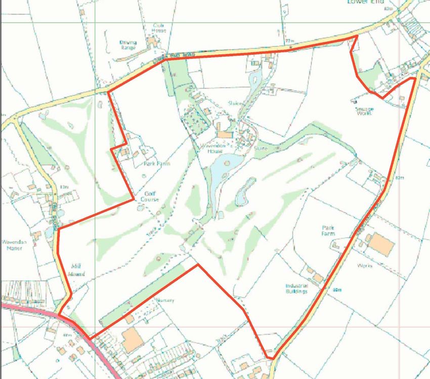
Bucks Gardens Trust, Site Dossier: Wavendon House, MKDC May 2020

                               3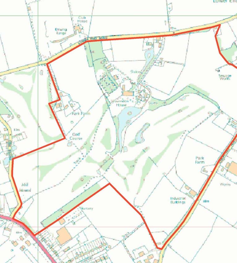
Bucks Gardens Trust, Site Dossier: Wavendon House, MKDC May 2020

INTRODUCTION

Background to the Project
This site dossier has been prepared as part of The Buckinghamshire Gardens Trust (BGT) Research
and Recording Project, begun in 2014. This site is one of several hundred designed landscapes
county‐wide identified by Bucks County Council (BCC) in 1998 (including Milton Keynes District) as
potentially retaining evidence of historic interest, as part of the Historic Parks and Gardens Register
Review project carried out for English Heritage (now Historic England) (BCC Report No. 508). The list
is not definitive and further parks and gardens may be identified as research continues or further
information comes to light.

Content
BGT has taken the Register Review list as a sound basis from which to select sites for appraisal as
part of its Research and Recording Project for designed landscapes in the historic county of Bucks
(pre‐1974 boundaries). For each site a dossier is prepared by volunteers trained on behalf of BGT by
experts in appraising designed landscapes who have worked extensively for English Heritage/Historic
England on its Register Upgrade Project.

Each dossier includes the following for the site:
       A site boundary mapped on the current Ordnance Survey to indicate the extent of the main
       part of the surviving designed landscape, also a current aerial photograph.
       A statement of historic significance based on the four Interests outlined in the National
       Planning Policy Framework and including an overview.
       A written description, derived from documentary research and a site visit, based on the
       format of the English Heritage (now Historic England) Register of Parks & Gardens of special
       historic interest 2nd edn.
       A map showing principal views and features.

The area within the site boundary represents the significant coherent remains of the designed
landscape. It does not necessarily include all surviving elements of the historical landscape design,
which may be fragmented. It takes no account of current ownership.

NOTE: Sites are not open to the public unless advertised elsewhere.

Supporters and Acknowledgements
The project was supported by The Gardens Trust (formerly the Association of Gardens Trusts and the
Garden History Society) and funded by BGT with significant grants from the Stanley Smith
Horticultural Trust, the Finnis Scott Foundation, BCC and other donors. BCC generously provided
current and historic mapping and access to the Historic Environment Record was provided by Milton
Keynes Council.

The Trust would like to thank the volunteers and owners who have participated in this project and
given so much time and effort to complete this challenging and rewarding task.

Further information is available from: www.bucksgardenstrust.org.uk

                                                     4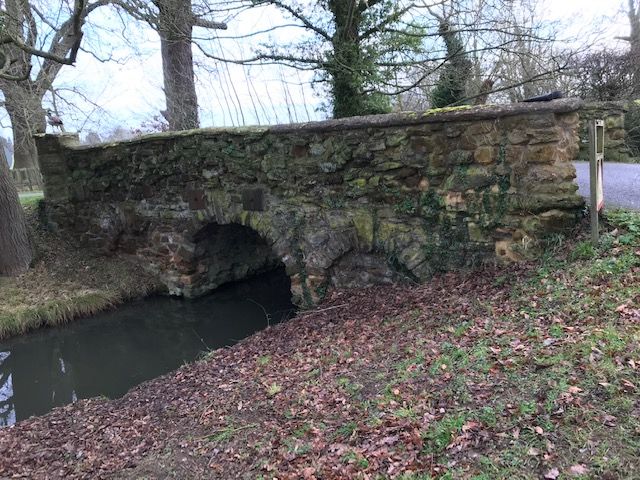
Bucks Gardens Trust, Site Dossier: Wavendon House, MKDC May 2020

COUNTY:
DISTRICT:
                         BUCKINGHAMSHIRE
                         MILTON KEYNES
                                                                   Wavendon House
PARISH:                  WAVENDON
OS REF:                  SP 923 377
NB This dossier amplifies the Historic England Register of Historic Parks and Gardens entry for
Wavendon List Entry Number: 1458292 (published November 2019).

STATEMENT OF SIGNIFICANCE (see also Appendix)

Overview

A late C18 country villa pleasure ground and possibly drives by Richard Woods, typical of his style,
which survives largely intact, with late C18/early C19 additions for the Hoares of Stourhead, and
extensive later C19 park additions that complemented Woods’ work. It has been little altered since
the 1880s although localised modern development has damaged parts of the site.

Archaeological interest

Motte and Bailey north of southern entrance (Mill mound); remains of icehouse in park west of
north entrance; enclosure near Wavendon House defined by shallow ditches probably post-dates
the adjacent ridge & furrow (Post Medieval) defined on all sides by broad shallow depression. Ridge
& furrow within enclosure in line with that outside to north-west, cut by enclosing depression. The
potential exists for features related to lost features of the pleasure grounds and park. Evidence of
lost garden features may include paths, walls, greenhouses and service buildings, and other buildings
and the ornamental layout of elements evident on historic maps.

Architectural interest

Grade II* house, Grade II stables, coach house and lodges, Woods' ornamental bridges, c. 1760s.

Artistic Interest

The designed landscape shows three major phases of development. Initially the Richard Woods
design, 1768-72; then for Henry Hoare from 1798 into the early C19, when the aspect of the house
appears to have been changed from north to south-facing and the mid-C19 expansion of the park.
Much of this layout survives intact.

The detail of Woods’ scheme remains unclear but analysis of the surviving fabric of the pleasure
ground and drives suggests it remains largely intact, with later developments incorporating it at the
heart of the landscape design. Two drives, with the lakes and park can still be traced, despite part of
the design being somewhat blurred by the golf course to the south, it retains the historic boundary,
some historic trees and parkland.

The Hoare family's later C18 and C19 alterations to the house developed and extended the
ornamental design considerably, including the park, with additional interest in the context of their
outstanding C18 estate at Stourhead. The exact nature and extent of their landscape work remains
unclear, but it was apparently in Picturesque style, with C19 planting belts framing the southern lake

                                                     5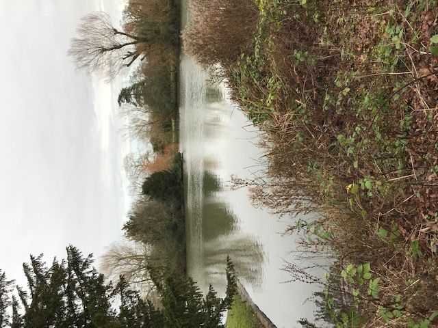
Bucks Gardens Trust, Site Dossier: Wavendon House, MKDC May 2020

which survive, including a large laurel hedge. Some later C19 walks, shrubberies and beds near the
house have been replaced by, or have reverted to lawns.

Key aspects of the artistic significance include:

* pleasure grounds and drives by a significant C18 landscape designer, reflecting the taste of the
period, and transforming the setting of a house by the skilful use of water;

* the substantial survival of a Woodsian scheme that on other sites tend to be incomplete or
overlain by subsequent remodelling;

* the late C18 and C19 development of the design, and early C20 development of the walled garden;

Woods’ original design survives largely intact within the pleasure grounds, together with the
relationship with the house, and other important landscape features.

Historic Interest

* enhancement of an estate within easy reach of fashionable London and Woburn, with work for the
influential Hoare family;

* C18 patronage, where Woods, a Catholic, worked for both Catholic and Protestant employers.

HISTORIC DEVELOPMENT

In 1653 James Selby purchased the manor and other land at Wavendon. In 1688 he was succeeded
by his son, also James Welby. His son Thomas James Welby inherited the estate in 1724, greatly
enlarged the house, made handsome gardens, canals and fish ponds and planted orchards and
avenues of trees (VCH, Lipscomb).

The pleasure grounds at Wavendon House were laid out in 1768-72 by Richard Woods. He was
employed to enhance an existing estate within easy reach of fashionable London. He created two
pear-shaped lakes, to the north and south of the house, linked by a canal. His work here ended on
the death of his employer (Cowell, 2009). The two bridges, one with a small cascade (listed Grade II),
may also be his work as they resemble known designs by Woods but are first shown on the 1841
tithe map. They also bear a resemblance to those at Weston Park Weston Underwood.

By 1791 the estate was in the possession of Robert Shuttleworth and the 1791 Enclosure included
several exchanges of land in respect of ‘the Park’ (CBS Q/RX/4, IR74 and IR74A) indicating the
presence of a park to some extent.

In 1798 the estate was bought by Henry Hoare, later of Stourhead, Wiltshire. His reasons for
obtaining the property are unclear but may have been influenced by its elevated position on the
Greensand Ridge, with its combination of good farmland and acidic soil, which lent itself to hunting
estates, and its proximity to London and the social life of nearby Woburn Abbey, with which the
owners had business connections, and the cluster of other eminent country houses on the Ridge.
The house was extended and probably reversed to face the southern lake (Lipscomb and Sheahan).

In 1815 Wavendon House was called Wavendon Hall (OSD). The house stood in the centre of the
pleasure grounds, surrounded by the park with the two lakes to the north-east and south.

                                                      6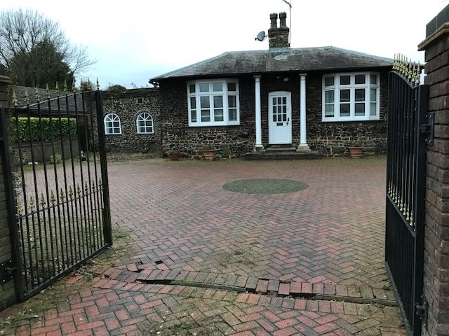
Bucks Gardens Trust, Site Dossier: Wavendon House, MKDC May 2020

Woodland lay to its east. The estate was shown as parkland studded with occasional trees, distinct
from the enclosed fields beyond. The main access to the Hall was via the avenue from the south-
west but there was also access from the south and north. A stable block, or other ancillary building
stood east of the house with the walled garden to the north-west of the house. The Walled Garden
comprised several rectangular plots in similar form to the later C18 walled garden at Stanmer, West
Sussex.

Sir Henry Hugh Hoare died in 1841. No significant changes had taken place since 1815 (OSD; Tithe
Map). For much of the rest of the century the house was let to tenants (Kelly’s Directory).

In 1862 Wavendon House had a ‘rural and retired’ situation, approached via a ‘neat lodge and a
carriage drive through an avenue of trees nearly ½ a mile in length’. The pleasure grounds and
shrubberies were noted as ‘tastefully arranged’ (Sheahan). By 1880 the house and ancillary
buildings were surrounded by a pattern of garden and pleasure ground paths, the two lakes and a
mixture of conifer and deciduous trees. A boat house stood by the southern lake. Lodges stood at
the north and south entrances (OS).

The majority of the estate was given over to an open tract of pasture with trees scattered
throughout. (OS)

The Hoare family were in residence at The Lodge, Wavendon in 1891 (Census) and resided on the
estate until 1895 when Sir Hugh Henry Arthur Hoare inherited Stourhead from his cousin. On
Thursday 7th February Lady Alda Hoare wrote in her diary ‘Henry & I left our dear old house,
Wavenden, with deep regret’ (Diary of Lady Alda Hoare).

An 1897 document relating to the subsequent rental of Wavendon House shows parts of Crabtree
Farm, Deeth Farm, Home Farm and Cross End Farm as part of ‘The Park’ (CBS ST154). The 1898 OS
depicts the landscape design at its zenith. Within the immediate environs of the house the buildings
and paths remained largely the same. Much of the contents of the house were removed to
Stourhead in 1908 following a serious fire there in 1902.

Harry Hoare, the heir apparent, was killed in 1917 and in 1918 the estate was advertised for sale,
described as ‘Estate 1169 acres. Beautiful pleasure grounds, rose garden, flower bed, tennis lawn,
croquet court, completely walled kitchen garden, range of glasshouses including peach house, early
and late vinery and carnation house.’ The main drive, from the south-west, was ‘lined by fine elms
and ½ a mile long’. There was also a ‘superior lodge entrance of brick and a secondary drive with
flint-built lodge’ (Hamptons, D-WIG/2/6/146 and 167 CBS). The house and gardens (c. 160 acres)
continued to be occupied by the tenant F.E. Bond (Kellys). The remainder was sold.

The house remained the property of Sir H. H. A. Hoare in 1927 with Mr. Bond still in residence (VCH).
The house, grounds and 42 acres were finally sold in 1935 to Stuyvesant Henry Le-Roy Lewis Esq.
(Northampton Mercury, 12 April 1935; Bedfordshire Times, 15 March 1935; Bedfordshire Times, 3
July 1936 and Kelly’s Directory). The offer included ‘the beautiful grounds, two lakes, Elm Avenue,
well – timbered park of 154 acres and two lodges’ (James Styles and Whitlock catalogue).

The house served as an outpost of Bletchley Park during WWII with both staff and Bombe machines
being housed there. The house and ancillary buildings were converted to a residential special school

                                                    7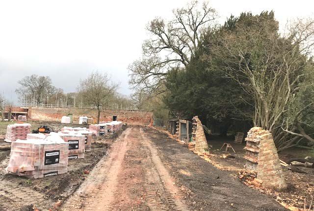
Bucks Gardens Trust, Site Dossier: Wavendon House, MKDC May 2020

in the 1950s; subsequently the main house was extended to the north-west and a small number of
new buildings were constructed in the vicinity (OS and Rutherford).

In the 1980s the house and service buildings were divided into flats and a modern block of garages
was built north of the Walled Garden, along with an access road from the northern driveway and a
small visitor parking area. A new house was built at the south end of the south lake. The house and
immediate grounds are in private divided ownership. Approval was granted in January 2019 for the
development of three houses to the north-west of the walled garden in the former orchard
(17/00823/FUL MKDC Planning application). Much of the park was turned into a golf course, which is
no longer in use but remains in private ownership.

SITE DESCRIPTION

LOCATION, AREA, BOUNDARIES, LANDFORM, SETTING

Wavendon House is 7km east of the centre of Milton Keynes, 1 km south-west of the M1 Motorway,
(3.3 km west of Junction 13). The parish is bordered on the north and east by Bedfordshire. The soil
is stiff loam and sand, the subsoil clay and gravel. The land is about 220 ft above sea level (VCH). The
site slopes very slightly to the north-west and to the south-east the ground rises towards Woburn
and Apsley Heath.

The north boundary is formed by Lower End Road. To the south-west are Park Farm, parts of which
lie within the former parkland of Wavendon House and Cross End. To the north-east is Lower end
with Cranfield Road forming the rest of the south-eastern boundary. Deeth Farm lies at the
southern tip and parts of the farmland were part of the park.

The 75 ha. site is relatively flat, without major wider views. Within the site the view from Wavendon
House towards the lake designed by Richard Woods survives largely unaltered. Other important
views are those towards the house and the walled garden from the Milton Keynes Boundary Walk
(MKBW) that approaches the house via part of the historic access road from the south-west through
the park, now golf course, leading past the south side of the walled garden and main house.

The site would have been framed by mixed farming and rural approaches, lined with trees. It is
facing substantial development from housing and roads outside the historic boundary, as well as
from changes within.

ENTRANCES AND APPROACHES

The house is approached from the north-east via a drive, which follows the route of the approach
from the north-east which was present by 1788 (CBS Q/RX/4, IT74A) and in 1815 (OSD).

The Lodge (listed Grade II) at the start of this driveway is shown on the 1841 Tithe Map. It is an early
C19 single storey building constructed of greensand stone rubble, with a hipped slate roof. (HER
Listing)

This northern approach runs 225m south-west on a causeway east of the north lake. It is tree-lined
and framed by park, now open arable. The lake is wider at its north end, where there is an island.

                                                     8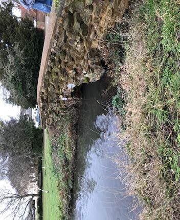
Bucks Gardens Trust, Site Dossier: Wavendon House, MKDC May 2020

The origin of this drive is unclear, and it is an unusually straight feature in Woods’ sinuous landscape.
It is possible that it survives from an earlier formal landscape, although it is not aligned
symmetrically on the C18 house (Rutherford). The driveway crosses the canal linking the north lake
to the south lake via an ornamental bridge (listed Grade ll), similar to one at nearby Weston Park
(qv). This bridge is of rubble greensand stone of brownish colour, with a central semi-circular arch
and flanking blank arches, all with rough stone voussoirs. From here a gravelled drive branches
north-west for 100m, leading to parking areas and garages with another branch after 35m leading to
the west, entrance front of the house. This corresponds to one of the routes present by 1880 (OS).

The drive continues south-east for 25m to the entrance to the former Coach House and stable block
20m east of the house then curves round the east side of the house to a gravelled turning circle
south of house. A central sundial stood here in the late C19 (1881 and 1898 OS), and early C20
(1918 catalogue map; early photographs). At one point it was surrounded by a ‘knot garden’ (Nat
Trust 7 206), at another it stood at the centre of a grass circle (Nat Trust 7 205). This sundial was not
shown by 1924 (OS), so it is possible it was moved to the walled garden, where there was one at this
date. It may have been returned from there to in front of the main house as a feature, and
something that looks like a sundial appears in photographs in the 1935 auction catalogue.
Photographs of the main house in the late 1940s do not show it.

A yew hedge leading from the south-west corner of this turning circle marks the route of the former
main drive to the house from Cross End.

The beginning of this drive from the south-west is marked by the remains of small well-defined
motte castle (listed Grade ll) on the flat top of a low hill to the north. The motte is slightly oval, 26m
by 22m. It rises to a flat summit at 3.4m with the sides of the mound eroded to give a terraced
appearance. Surrounding the motte is a shallow dry ditch from which material was quarried during
the construction of the mound. There is no evidence of a building on the summit with finds of
pottery limited to the C13. (HER Listing) It is also shown on maps as Mill Mound. To the south is the
C19 lodge, present by 1841 (Tithe Map) and mentioned by Sheahan in the 1860s as a ‘neat lodge’.
This red-brick, single storey lodge with tiled roof has been much altered and extended (Rutherford).

The former main drive continues 500m as a track north-east across the former golf course in the
south park, lined with C19 ornamental firs and conifers. It then becomes a grass footpath, part of
The Milton Keynes Boundary Walk leading after 30m to a gate. Beyond the gate into the pleasure
ground it continues as a gravel path reaching the turning circle after another 50m.

The origin of this drive is unclear but it was probably created when the main aspect of the house was
apparently shifted c.1798. It existed by 1815 (OSD) as the main access to the house, finishing at a
turning circle at the main, south facing entrance to the house.

Branching from this approach, where the Milton Keynes Boundary Walk meets the track across the
former golf course 80m south-west of the turning circle, a footpath continues west past Park Farm
to the hamlet of Cross End. The Milton Keynes Boundary Walk turns south and continues to Deeth
Farm.

                                                      9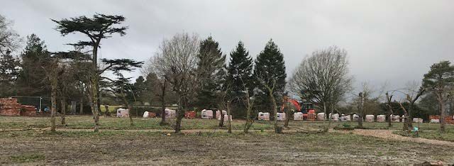
Bucks Gardens Trust, Site Dossier: Wavendon House, MKDC May 2020

In 1815 (OSD) an approach ran from Deeth Farm in the south, past the south-west tip of the south
lake before joining the main south drive. This drive does not appear on later maps but roughly
follow the line of the present Milton Keynes Boundary Walk.

PRINCIPAL BUILDINGS

Wavendon House (listed Grade ll*) stands slightly to the north of the centre of the site. Of late C17
origin it was enlarged c.1703 for James Selby and remodelled in 1798 for Henry Hoare. It is
constructed of painted brick and stucco with hipped slate roofs and has two storeys and cellars.

The south, entrance front, has views across the turning circle to the lake and the park beyond. A
Greek Doric porch has four plain columns. West of this is the c1798 wing and to the east is a lower
painted brick, C18, service wing. The west elevation of the 1798 wing has five bays and a central
semi-circular arched door. The northern elevation (formerly the entrance front) of the central block
has an early C19 half octagon to one storey in the centre of the ground floor. North of the 1798 wing
is a late C20 block. (HER Listing)

The Coach House (listed Grade II) stands 20m east of the house and has been converted to offices. It
is an early C19 building of painted brick with a tiled roof and three gabled dormers, with one storey
and an attic. (HER Listing) The original entrances for the coaches are visible.

The adjacent C18 Stable Block (listed Grade II), 25m to the east of the house, has been converted to
residential use. It is constructed of a single storey with an attic, painted brick with a hipped old tile
roof, three loft entries and one dormer on the west side, all gabled with scalloped bargeboards.
(HER Listing)

GARDENS AND PLEASURE GROUNDS

The c. 8ha. gardens and pleasure grounds lie immediately north, west and south of the house and
consist mainly of lawns studded with a few trees and a number of areas planted with shrubs and
other ornamental plants, some of them being the small, private gardens divided up for the current
residents. They are attributed to Richard Woods but the detail of his layout is unclear.

East of the front door, in front of the C18 service wing a small shrubbery surrounds the beech tree
which can be seen in many of the historic photographs of the south front of Wavendon House. The
shrubbery extends c35m south-east alongside the drive to the corner of the house. A further small
shrubbery screens the modernist ‘Lake House’. A footpath leads through this shrubbery to a bridge
(listed Grade ll) of rubble greensand stone of brownish colour, with a central semi-circular arch and
flanking blank arches, all with rough stone voussoirs. It is c.7.5m long, and 2.5m wide, and crosses
the canal, linking the two lakes. A weir by this bridge in 1898 (OS) has gone. It is contemporary with
the bridge north-east of the house carrying the north drive and in similar style but has been
considerably rebuilt.

South of the house, beyond the turning circle, a lawn leads down the 25m to the edge of the south
lake.

The rectangular lawn west of the house (c50m x30m), south of the Walled Garden, formerly a
croquet lawn, contains two mature mulberry trees. It is hoped that the ornamental planting at the

                                                     10
Bucks Gardens Trust, Site Dossier: Wavendon House, MKDC May 2020
south-east front of the Walled Garden, which formed a backdrop to this lawn and contained a large
wisteria, will survive the work being done to restore the Walled Garden. A further bed of ornamental
planting runs along the south-east side, backed by a yew hedge. The ornamental paths here in 1924
no longer exist (OS).
A further area of lawn containing trees and shrubs, bounded by the drives, lies north of the house. A
large horse chestnut, in the north-east corner, has recently been felled.
PARK
The gardens and pleasure grounds are surrounded by the park with specimen trees, clumps and
lakes.
The north park is almost rectangular, covering an area of c.27ha area. It consists mainly of grass,
divided by the former orchard and walled garden, the north drive from the north-east and field
boundaries, with arable land on the eastern edge.
The roughly triangular c.34ha south park, with an extension to the west, is dominated by the defunct
golf course, surrounding the south lake to the west, south and east.
The western end of the north park consists of rough pasture bounded by the drive to Park Farm on
the west and the former golf course beyond. To the east of this is the former orchard, now the site
of three new houses, and the Walled Garden. One damson tree is being kept in the garden of one of
the houses. The triangular area north of the house, bounded by the orchard and the drives is divided
into two, horizontally, by a mixed field hedge and is laid to grass with a few mature trees.
The tree-lined north drive from Lower End Road is lined by mature oaks to the east with planes,
interspersed with conifers and ornamental trees, and the adjacent lake to the west. An icehouse lay
south of the lodge at this north entrance to the park. All that now remains of this is a depression of
about 4m diameter, partly brick-lined and set into a slight mound. It is said to have been excavated
c.1976 but all that was found was some bottles, bricks and tile. The bottom was c.1m below the
present level (Pike). The icehouse does not feature on the 1918 sale catalogue map (Hamptons).
The area to the north-east, bounded by the north drive, Lower End Road, Cranfield Road and the
former golf course is pasture and arable land. At the north-east tip the lodge at 2 Lower End Road
(listed Grade ll), is a small, early C19, single storey house, pebble-dashed with a hipped slate roof.
(HER Listing)
The wooded park belt stands east of the house. It may be part of Woods’ design as its outline,
throughout the C19 and C20 echoes the pear-shaped nature of the lakes, being wider at the south-
west end and tapering towards the north-east. Historically it screened the house from the farmland
beyond, it now also provides a boundary with the former golf course.
The south lake is widest at this north end, tapering towards the south end and is significantly wider
than the north lake. It has two wooded islands and a varied border of trees and shrubs and a grass
path along the west edge passing steps leading down to the site of the former boathouse present in
1880 (OS). By 1924 there were two boathouses, the second being closer to the house on the east
11Bucks Gardens Trust, Site Dossier: Wavendon House, MKDC May 2020
side of the lake (0S). A laurel hedge on the east side of the lake is separated from the former golf
course by modern fences to the west and south.
Most of the south park was converted to a golf course in 1989 which operated until recently. The
area to the south retains a number of mature trees. Two large oak stand at the south end of the
south lake with many pollarded limes to the south-west. There was formerly an enclosure defined
by shallow ditches which probably post -dated the adjacent ridge and furrow and was outlined by
trees in the C19 (MK HER and OS). This is no longer evident. This area was historically managed as
pasture, studded with specimen trees and clumps.
Together the two lakes, with their fringes of trees and still connected by the canal with its bridges,
are important survivors of the C18 design; the outlines of which can still be clearly seen.
Park Farmhouse (Listed Grade ll) lies on the west edge of the park, 200m from the house. The two
storey, early C19 painted brick building has an early C17 rear block. The rear block is timber-framed
with brick infill and additions each end. (HER Listing)
In the C19 the park occupied 73.5 ha. enclosing the core of the designed landscape: the house,
stables, Walled Garden and pleasure grounds. The house was ‘pleasantly situated in a well-wooded
park of 118 acres’ (Kelly’s 1877). By 1935 the park was ‘well-timbered’ (Northampton Mercury,
1935).
KITCHEN GARDEN AND ORCHARD
The 0.5 ha. rectangular Walled Garden (52m wide x 76m long) lies 25m north-west of the house
beyond a lawn. It is surrounded by brick walls, historically of varying heights and width, altered on
several occasions, indicating various periods of rebuilding. Due to the poor condition most of these
walls are being rebuilt, with as many of the original bricks as possible being used in the rebuilding.
The Garden is probably of the later C18 or early C19 and was present by 1815 (OSD). In 1841 the
Walled Garden included two lean-to buildings, one against the north-west and one against the
south-east external walls (Tithe Map).
Sheds adjoining the north-west wall, are of brick and timber, with slated timber roofs. These
correspond in part those present by 1841 (Tithe Map). Two doors lead from the interior of the sheds
into the garden. These probably provided access to the greenhouses that formerly lined the
northern interior wall. A further door is present at the south-west end of this north-west wall.
By 1880 (OS) greenhouses lined the interior of the north-west wall of the walled garden. The date of
the demolition of these is unclear, but the location of the greenhouses is still indicated by a white
wash on the garden wall. Two further greenhouses lie in the area to the north, with the orchard
beyond. A building also seems to lie along the external wall at the south-east of the garden, forming
an extension of the earlier one. Neither building survives except for the foundations (Albion) and the
greenhouse does not appear on the 1898 map. These buildings suggest that the current entrance to
the garden from this side did not exist in 1880.
The cruciform paths follow the pattern evident by 1898 (OS). Path edging stones found have been
kept for re-use. A central capped well at the centre where the paths meet, has a stone basin
12Bucks Gardens Trust, Site Dossier: Wavendon House, MKDC May 2020
adjacent. The basin may have been catchment for a pump, one was present in 1898 along with a
further pump along the north-west wall (possibly linked to a remaining feature on this wall), and a
third pump at the southern external corner of the walled garden (OS). However, its function and
origin are unclear. It was present by 1881 (OS); by 1924 (OS) it had been replaced by a sundial. A
rainwater tank near the central doorway in the north-west wall, has a cover with the name of
Charles Sinfield and Sons, Contractors, Apsley Guise, noted in 1925 in the Woburn Sands telephone
directory.
The remains of a late C19 pear alley runs along the path along the north-west to south-east axis. The
trees were supported on a framework of wrought iron hoops, several of which survive and are partly
ingrown into some of the trees. The pear alley has 64 fruit tree positions and 56 positions are
supported by the iron hoops. Eight trees in total are positioned equally at the ends of each half and
each side of the pear alley and have no iron hoop. The pear alley halves are; north - 84’ long and
south - 98’ long with an overall length (including the intersection), of 202’. 28 trees are still alive
including damsons and plums as well as pears (Ives). This is a rare and exceptionally large survivor of
this type of feature.
Tall wrought iron gates in the south-east wall date from the late C19 or early C20.
The former orchard lies north-west of the walled garden. Three houses are being built in it, retaining
a mature damson tree. Two C19 greenhouses have recently been demolished, parts of which have
been retained in order to construct a lean-to greenhouse on the south-east wall. The origin of the
orchard is unclear, but it was present by 1815 (OSD), and may date from the mid-late C18.
REFERENCES
BOOKS AND ARTICLES
AKS Ward Construction Consultants, Wavendon Garden Wall, (July 2017)
Albion Archaeology, Land to North-West of Wavendon House, Wavendon, Milton Keynes: Heritage
Statement, (2016)
Bedfordshire Times and Independent (15 March 1935)
Bedfordshire Times and Independent, (3 July 1936)
Country Life, [Supplement], (April 20th 1918)
Cowell, Fiona, Richard Woods (1715-1793). Master of the Pleasure Garden, (2009)
Hampton & Sons for the Wavendon Estate, Auction catalogue, (23rd May 1918)
Historic England, Historic Parks and Gardens Register, Buckinghamshire: Wavendon (2019).
https://historicengland.org.uk/listing/the-list/list-entry/1458292
Ives G, Dir, Wavendon House Manag. Co. The Lost Walled Garden of Wavendon House, (July 2017)
James Styles and Whitlock, Auction Catalogue, (1935)
Kelly's, Post Office Directory of Berks, Bucks and Oxon, (1883, 1887, 1895, 1899, 1903, 1915,1920,
1924, 1928, 1935 and 1939)
Lipscomb, History and Antiquities of the County of Buckinghamshire, (1847) Vol. lV p395
Pike, A. R., Field Visit to Wavendon House, (Oct 1980) SMK3440 and SMK3451.
Rutherford, Dr. S, Wavendon House site appraisal Bucks Gardens Trust, August 2018 (see Appendix)
Sheahan, J.J., History and Topography of Bucks, (1862)
Northampton Mercury, (12 April 1935)
13Bucks Gardens Trust, Site Dossier: Wavendon House, MKDC May 2020
Victoria County History, A History of the County of Buckingham, Volume. 4 (1927) pp489-496.
MAPS
Jeffreys, T., Map of the County of Buckinghamshire surveyed in 1766-1768 (1770)
Wavendon Enclosure Award and Reconstruction of Map, [CBS IR74 and 74A], (1791)
Ordnance Surveyor’s Draft, c1815
Bryant, A., A Map of the County of Buckinghamshire… in the year 1824 (1825).
OS 6” Surveyed: 1880 Published: 1885
OS 6” Revised: 1898 to 1900, Published: 1902
OS 25” Surveyed: 1898, Published: 1901
OS 6” Revised: 1924 Published: 1926
OS 6” 1950–52
OS 1:2,500, 1972
OS Explorer Map 2007
ARCHIVAL ITEMS
Centre for Buckinghamshire Studies
D/WIG/2/6/146 and 167 Auction sale particulars for Wavendon Estate (1911)
Q/RX/4 Inclosure awards for Wavendon, (1791)
ST154 Terrier and Rental of the Wavendon Estate. P9 (1897)
1891 Census
National Trust Collections – Stourhead
Diaries of Alda Hoare 1894 – 7
Photographs 7 206 Riders outside Wavendon, 7 205 View from the front of Wavendon,
IMAGES
accessed Nov 2019
http://www.ampthillimages.com/Media/Wavendon-Gall/pages/1948%20Manor%20House%2006.html
http://www.ampthillimages.com/Media/Wavendon-Gall/pages/1948%20Manor%20House%2004.html
https://i.pinimg.com/736x/f2/ff/96/f2ff966d0fd0f7d78fadf9c2b34b5f1e.jpg
accessed Jan 2020
http://www.nationaltrustcollections.org.uk/object/732540 http://wwwhttp://www.basildongolfcourselp.com/page29.htm
Which.nationaltrustcollections.org.uk/object/732406
J Stansfield & G Grocott, January 2020 Edited SR February 2020
Issued April 2020; revised May 2020
14Bucks Gardens Trust, Site Dossier: Wavendon House, MKDC May 2020
KEY HISTORIC VIEWS
15Bucks Gardens Trust, Site Dossier: Wavendon House, MKDC May 2020
KEY HISTORIC FEATURES
15
11
5 10
9
3
7
1 2
6
8
4
17
12
14
17
13
17
Key to numbered features
1. Wavendon House 2. Stables & Coach House
3. Walled Garden 4. South Lake
5. North Lake 6. Turning circle/forecourt
16Bucks Gardens Trust, Site Dossier: Wavendon House, MKDC May 2020
7. Bridge NW of house 8. Bridge SE of house
9. Former orchard 10. North Drive
11. Lodge to North Drive 12. Route of former main drive from Cross End
13. South Lodge 14. Motte/mill mound
15. Lodge 2 Lower End Road 16. Former SE drive from Deeth Farm
CURRENT IMAGES
Bridge north east of House Bridge south west of House
Croquet Lawn Entrance to Walled Garden Lodge to north drive
17Bucks Gardens Trust, Site Dossier: Wavendon House, MKDC May 2020
Former main drive from lake end The former main drive from the The Motte
west
Walled Garden Feb 2020, north-west wall with the remains of the sheds, present in 1841, being
rebuilt and including original bricks (courtesy of David Heath). The walls were present by 1815.
Walled Garden Feb 2020 (courtesy of David Heath).
Site of the south-west wall, being rebuilt including original bricks. The walls were present by 1815.
18Bucks Gardens Trust, Site Dossier: Wavendon House, MKDC May 2020
APPENDIX
Wavendon House site appraisal submitted by Bucks Gardens Trust to Historic England
August 2018 Dr S Rutherford
Three major phases of landscape development are apparent from documentary and site evidence:
1. 1768-72 designer Richard Woods: core of site, water and possibly drives, incorporating an area that
originated as a manor house site possibly with earlier work incorporated. The extent of the park in his time is
unclear but Cowell identifies the key features at the core that are likely to be by Woods. In addition the
drives may also be his.
2. 1798 onwards for owner Hoare when aspect of house is changed to south-facing. Unclear the extent of
landscape works carried out for him.
The cumulative effect of these two late C18 phases is mapped by 1815 (OSD). The parkland is relatively simple and is
the setting for the core and the drives.
3. Mid-C19 park expansion by 1880s (OS): seamless ornamentation of agricultural land as the essential
ornamented setting for established drives and core which are retained. This is of good quality design and
complements and frames the earlier phases well.
1815 OSD by end of second phase of landscape development
19Bucks Gardens Trust, Site Dossier: Wavendon House, MKDC May 2020
1898 OS by completion of third phase of landscape development.
Extent of park by 1815 (approx) show within black line.
Red areas = C19 additions that should be included in Registered area where not irreversibly altered.
Historic Design Context for Richard Woods
Based on BGT’s knowledge of the list of Registered parks with work by Woods, and information from Fiona Cowell’s
book on Woods including her gazetteer of all sites associated with him, we conclude that his major schemes for
which considerable evidence survives on site are Brocket Hall, Herts; Cannon Hall, Yorks; Cusworth Hall, Doncaster;
Hartwell House, Bucks; Wardour Castle, Wilts
The design of Wavendon is not it seems to the same level of complexity of Woods’ work as the above. It is
apparently more comparable with sites of somewhat lesser complexity, but which are typical of his competent
design and still retain good survival such as Hatfield Priory, Essex, Old Alresford House, Hampshhire, and New Hall,
Boreham (all GII).
Survival of Wavendon
Fiona Cowell notes that although lacking an archive to provide the detail, Wavendon is an excellent example of the
transformation of the setting of a house using skilfully laid out pieces of water. His putative 2 lakes and
20Bucks Gardens Trust, Site Dossier: Wavendon House, MKDC May 2020
bridges/cascades, and linking drives, have not been superseded by a later landscape scheme and the core remains
legible despite the house being reversed in the 1790s. Many of Woods’ other schemes have ben overlain, or are part
of a larger designed landscape. Even if some of this work was carried out in the second phase taken together it is a
good example of the late C18 English Landscape style.
Much of the first two phases at Wavendon survives, both at the core and the two drives with localised C20
development that does not significantly damage the key design features.
Woods’ typical schemes were founded on pleasure ground and walled garden ensembles. Here the kitchen garden
may be part of his scheme and survives, together with other pleasure ground features on an earlier site. The setting
of these C18 features is of high importance, including the C18 parkland and drives, and the C19 extension
encompassing the drives and core established by 1815.
The later parkland adds its own considerable interest to the site, extending the original area in similar style, and
contributes to the significance of the design. It survives largely intact and is not irreversibly developed. Despite part
of the design being somewhat blurred by the golf course to the south, it retains the historic boundary, historic trees,
the C18 south drive and C19 South Lodge, and could be restored to parkland.
Significance
A late C18 country villa pleasure ground and possibly drives by Richard Woods, typical of his style, which survives
largely intact, with C19 additions that complemented Woods’ work, and has been little altered since the 1880s.
Conclusion
We conclude that Wavendon Hall as developed by 1900 represents a nationally significant design, containing at the
core a good survival of a typical C18 pleasure ground scheme with work by designer Richard Woods. The main
elements of the C18 landscape are essentially complete, including the Woods core around the house and drives and
the C19 extension also largely survives.
The whole area is thus suitable for designation and meets the criteria for Grade II, being of similar historic design
significance and survival to other registered sites of the period.
We strongly believe that the proposed boundary is too tightly drawn. It omits the drive to the SSW shown on the
1815 map. This is an essential element of the significance/special historic interest of the C18/early C19 landscape,
and therefore should be included in the designated area. We strongly suggest that the park boundary line on the
1898 OS is followed as far as possible as this represents the landscape design at its zenith with almost not loss to
irreversible development. The small pockets of irreversible development which have occurred around North Lodge
and on the east boundary do not reduce the significance of the historic design to any major degree.
21You can also read