Land Registry Practice Guide 40 Oct 2005
←
→
Page content transcription
If your browser does not render page correctly, please read the page content below

Land Registry
Practice Guide 40
Oct 2005

Land Registration Act 2002
Scope of this guide                       Land Registry plans
This guide provides background
information about the plans records
held and maintained by Land Registry.
It also explains the pre-registration     A summary of
requirements for lodging plans in
different types of applications and
                                          — Land Registry plans records
covers various other plans-related
services we offer. It is aimed at legal
                                          — pre-registration requirements
advisers and land professionals such
as surveyors; you should interpret
                                          — other plans related services
references to “you” accordingly. Land
                                          Update – This edition of the guide replaces the March 2003 edition. Section
Registry staff will also refer to it.
                                          3 and Appendix 3 have been amended as a result of a review of our practice
Information is also available in other    on determining boundaries.
practice guides and public guides
(written in a non-technical way) – see
section 9 Enquiries and comments.

Contact details
You can obtain copies of this and all
our other guides free from any Land
Registry office, and view or download
them from our website in English
and Welsh.

This publication can be made
available in alternative formats
on request. If you or any of your
colleagues require an alternative
format please contact Customer
Service at Land Registry Head Office.

You can find details of Land Registry
offices, telephone numbers and
opening times on our website.
Telephone numbers are also
listed under ‘Land Registry’
in the Phone Book.

www.landregistry.gov.uk

1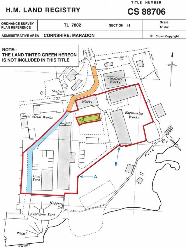
2
Land Registry
Practice Guide 40
Oct 2005

                    Land Registry plans
                    1     Introduction                                                             5

                    2     Land Registry plans based on the Ordnance Survey map                     5
                    2.1   Ordnance Survey base map                                                 5
                    2.2   Scale and accuracy                                                       8
                    2.3   Feature representation on Ordnance Survey maps                           8
                    2.4   Availability of Ordnance Survey maps                                     9
                    2.5   Copyright                                                                9

                    3     Boundaries                                                               11
                    3.1   Definition of a boundary                                                 11
                    3.2   General boundaries and Land Registry plans                               11
                    3.3   Determined boundaries                                                    11
                          3.3.1 What is a determined boundary?                                     11
                          3.3.2 Determined boundary plan requirements                              11
                          3.3.3 Involving adjoining owners                                         12
                          3.3.4 Method of application to determine a boundary                      14
                          3.3.5 Use of National Grid coordinates                                   14
                    3.4   Fixed boundaries                                                         14
                    3.5   Ownership of fences                                                      14
                    3.6   Party Wall etc, Act 1996 (the Act)                                       15
                    3.7   Accretion and diluvion (non-tidal rivers and streams)                    15

                    4     Index map                                                                16
                    4.1   Purpose                                                                  16
                    4.2   Format                                                                   16
                    4.3   Specification                                                            16

                    5     Title plans                                                              18
                    5.1   How we prepare title plans                                               18
                    5.2   Surveys                                                                  18
                    5.3   The land in a title                                                      19
                    5.4   Easements                                                                19
                    5.5   Measurements                                                             20
                    5.6   Areas                                                                    20
                    5.7   Plans supplementary to the title plan                                    20
                    5.8   Revision, replacement and amendment of the title plan                    21

                    6     Requirements for identification of land to be registered                 26
                    6.1   Identification of land in deeds lodged for registration                  26
                    6.2   First registrations                                                      26
                    6.3   Transfers of part and dispositionary leases                              29
                    6.4   Unusual land extents                                                     29
                    6.5   Plans for use in deeds                                                   29
                    6.6   Plans reduced in scale                                                   30
                    6.7   Detailed plan requirements under LRR 2003                                30
                    6.8   Property descriptions                                                    30

                    7     Inadequate identification of land                                        31
                    7.1   Differences between parcels and plans                                    31
                    7.2   Poor quality plans                                                       31
                    7.3   Conveyances by description only                                          31
                    7.4   Plans for identification purposes only                                   31
                    7.5   Completion of the title plan as an alternative to raising requisitions   32

                    8     Other plans related services                                             32
                    8.1   Search of the index map service                                          32
                    8.2   Title plan office copy service                                           32
                    8.3   Developing estates – registration services                               32

3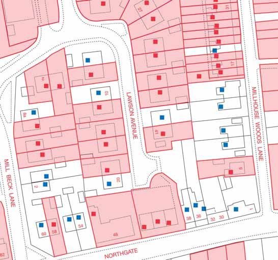
Land Registry
Practice Guide 40
Oct 2005

                    9   Enquiries and comments                                      32

                    10 Forms and fees                                               33

                    11 Appendix 1 Scale and accuracy of the Ordnance Survey map     33

                    12 Appendix 2 Legal presumptions                                34

                    13 Appendix 3 Example form DB                                   36

                    14 Appendix 4 BS1192 Part 3 British Standard for Construction   38
                       Drawing Practice

                    Land Registry advisory policy                                   40

4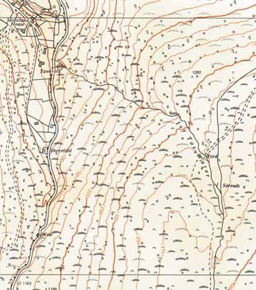
Land Registry
Practice Guide 40
Oct 2005

                    1 Introduction
                    This guide describes the following subjects that involve plans and the work
                    of Land Registry.
                    — Ordnance Survey map.
                    — Boundaries.
                    — Index map.
                    — Title plans.
                    — Plans for applications.

                    Land Registry maintains a map that records whether any registered title
                    (other than a relating franchise or lordship) affects a parcel of land – s.68,
                    Land Registration Act 2002 (“LRA 2002”). This map is based on the Ordnance
                    Survey map and is called the index map – r.10(a), Land Registration Rules
                    2003 (“LRR 2003”). See section 4 Index map.

                    Each individual registered title has a title plan. Its purpose is to provide a plan
                    of the land included in a registered title and the extent of land affected by
                    entries on that individual register. It must always be viewed in conjunction with
                    the register. The title plan used to be known as the ‘filed plan’ and you may still
                    see it described in this way.

                    The only types of registered titles that do not have title plans are relating
                    franchises and lordship titles. A verbal description of these registrations is held
                    in the index of relating franchises and manors – r.10(b), LRR 2003.

                    As our title plans are based on the Ordnance Survey map (r.5(a), LRR 2003)
                    an insight into its conventions and accuracy is contained in section 2 Land
                    Registry plans based on the Ordnance Survey map.

                    This guide also provides information on the boundaries of registered titles.
                    The majority of titles only establish the general boundary of the land. This is
                    an approach that allows land to be registered and dealt with while avoiding the
                    need for extensive enquiry into the exact line of a boundary (which may give
                    rise to a dispute). See section 3 Boundaries.

                    One of the most important factors that Land Registry takes into account when
                    preparing a title plan is the plan lodged with an application. It is in the applicant’s
                    interest that the plan lodged with their application or used in a deed meets
                    basic standards of accuracy. See section 6 Requirements for identification of
                    land to be registered.

                    2 Land Registry plans based on the
                    Ordnance Survey map
                    2.1 Ordnance Survey base map
                    Until quite recently, Land Registry title plans and the index map were based
                    on the large-scale paper maps published by Ordnance Survey.

                    These maps were published at the following scales.
                    1/1250 scale (1cm = 12.5 m) in urban areas. See Example 1.
                    1/2500 scale (1cm = 25 m) in rural areas. See Example 2.
                    1/10000 scale in mountain and moorland areas. See Example 3.

5
Land Registry
Practice Guide 40
Oct 2005

                    Example 1
                    Scale 1/1250

                    © CROWN COPYRIGHT. Produced by HMLR. Further reproduction in whole or part is prohibited without
                    the prior permission of Ordnance Survey.

6
Land Registry
Practice Guide 40
Oct 2005

                    Example 2
                    Scale 1/2500

                    © CROWN COPYRIGHT. Produced by HMLR. Further reproduction in whole or part is prohibited without
                    the prior permission of Ordnance Survey.

                    Example 3
                    Scale 1/10000

                    © CROWN COPYRIGHT. Produced by HMLR. Further reproduction in whole or part is prohibited without
                    the prior permission of Ordnance Survey.
7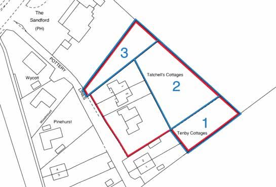
Land Registry
Practice Guide 40
Oct 2005

                    Land Registry title plans (as described in section 5 Title plans) are now produced
                    using Ordnance Survey’s definitive large-scale digital map data. This is supplied
                    and maintained in a single consistent format but is surveyed and digitised at
                    different scales (the same as the previously published paper maps) according
                    to location. See Example 4.

                    The index map (as described in section 4 Index map) has been converted into
                    an electronic map format using the Ordnance Survey digital map as its base.

                    Example 4
                    Digital map data

                    © CROWN COPYRIGHT. Produced by HMLR. Further reproduction in whole or part is prohibited without
                    the prior permission of Ordnance Survey.

                    2.2 Scale and accuracy
                    Perfect accuracy in survey measurement and the drawing of features on a
                    plan is unattainable even when using the highest order of survey techniques.
                    Ordnance Survey maps are therefore subject to specified accuracy tolerances.
                    This will mean, for example, that measurements scaled between features
                    shown on the Ordnance Survey map will not exactly match the actual distance
                    measured between the same features on the ground. Different levels of accuracy
                    apply dependent on the scale of the map and the original method used to
                    create it. Ordnance Survey publishes expected confidence levels in the accuracy
                    of their maps in terms of absolute and relative accuracy.

                    Further details on the scale and accuracy of Ordnance Survey maps,
                    including examples of its application, are contained in Appendix 1.
                    This information is also available on Ordnance Survey website at
                    www.ordnancesurvey.co.uk

                    The copying, reducing or enlarging of any plan is likely to distort its accuracy.

                    2.3 Feature representation on Ordnance Survey maps
                    The Ordnance Survey map shows permanent physical features, normally at
                    ground level, together with a variety of descriptive information and symbols.
                    Generally, the Ordnance Survey map shows features over 0.3m high by firm

8
Land Registry
Practice Guide 40
Oct 2005
black lines and those less than 0.3m high by dotted black lines. Within private
gardens the only features the Ordnance Survey map shows are permanent
buildings over 12 sq metres in area, roads and tracks over 100m long and
other continuous features such as streams and features that mark the line
of an administrative boundary.
The way features are shown on an Ordnance Survey map will depend on the
scale of the map. For example, a feature such as a small jut or porch of a main
building may not be shown at all on a 1/2500 map but could be shown on a
map at 1/1250 scale. Another example would be where there are two features
close together on the ground but only one feature is shown on the Ordnance
Survey map. This is because the gap between the features cannot be shown
at the scale at which the map was drawn.
Ordnance Survey publishes details of how features are shown on their large-
scale maps. Further information is available on the Ordnance Survey website
address mentioned in section 2.2 Scale and accuracy.
2.4 Availability of Ordnance Survey maps
You can obtain Ordnance Survey maps in a variety of forms including, for
example, customised extracts and enlargements. It is not Land Registry’s
role to supply extracts of Ordnance Survey maps it holds, either generally
or for conveyancing purposes. Ordnance Survey, through its stockists, can
supply up-to-date extracts of its maps.
You will find information on your nearest Ordnance Survey stockist on
the Ordnance Survey website address mentioned in section 2.2 Scale
and accuracy.
2.5 Copyright
All Land Registry plans are Crown copyright and all rights are reserved.
Please email any enquiries regarding copyright to
copyright@landregistry.gov.uk
9Land Registry
Practice Guide 40
Oct 2005
Example 5
Aerial photograph of physical features with corresponding Ordnance
Survey map at 1/1250 scale.
© CROWN COPYRIGHT. Produced by HMLR. Further reproduction in whole or part is prohibited without
the prior permission of Ordnance Survey.
© CROWN COPYRIGHT. Produced by HMLR. Further reproduction in whole or part is prohibited without
the prior permission of Ordnance Survey.
10Land Registry
Practice Guide 40
Oct 2005
3 Boundaries
3.1 Definition of a boundary
The word ‘boundary’ has no special meaning in law. In land ownership,
it is understood in two ways.
— The legal boundary – is the line, which is not visible on the ground, that
divides one person’s land from another’s. It is an exact line having no
thickness. It is rarely identified with any precision either on the ground
or in the deeds.
— The physical boundary – is a feature such as a fence, wall or a hedge.
The legal boundary may be intended to follow the physical boundary but this
is not always the case. For example, the legal boundary may run somewhere
within a feature or, along one particular side or, beyond its near or far side,
or include all or any part of an adjoining roadway or stream.
Example 5 shows a photograph of physical boundaries in a residential area
and how they are represented on an Ordnance Survey map.
3.2 General boundaries and Land Registry plans
The precise position of the legal boundary is often unclear because of:
— the difficulty in defining the boundary as mentioned in the preceding
paragraph
— the deeds are often silent on this issue
— the legal presumptions which may apply to determine ownership
(see Appendix 2).
This means the great majority of land in England and Wales is registered with
general boundaries only. As a result, it is not possible to identify the position
of the legal boundary from the register of title and title plan.
For further information see Public Guide 6 – Boundary questions.
3.3 Determined boundaries
3.3.1 What is a determined boundary?
This is a procedure that allows for the exact line of a boundary to be
determined and recorded on a registered title (s.60, LRA 2002).
An alternative and less demanding method for adjoining owners to clarify
a boundary is by entering into a formal boundary agreement and applying
for it to be noted on the individual registers. This will effectively record the
agreement, but will not determine the exact line of the boundary of the
registered title under s.60, LRA 2002. Public Guide 6 – Boundary questions
contains more information about boundary agreements.
3.3.2 Determined boundary plan requirements
— The plan supporting an application to determine the exact line of
a boundary must:
— show sufficient surrounding physical features to allow the position
of the boundary to be drawn on the Ordnance Survey map.
If the plan does not allow the boundary to be identified on the
Ordnance Survey map the application will be rejected
— identify the start, end and any turning points of the
determined boundary
— be drawn accurately to a stated recognised scale. We advise that this
is no smaller than 1/200.
— Measurements shown on the plan need to be both precise and accurate
to 10mm and should be taken from at least two defined points on
surrounding permanent features. In this context ‘permanent features’ are
taken to be physical features, which it is reasonable to assume will remain
11Land Registry
Practice Guide 40
Oct 2005
in position for at least 10 years, taking into account the nature and
construction or character. The measurements must be taken horizontally,
that is not along a slope.
— Any measurements must be from precise points on physical features such
as the corners of buildings. Measurements from features that are subject to
natural growth or decay cannot meet the accuracy requirements. If possible
measurements should be taken from both sides of the boundary.
— The specific relationship of the boundary to physical features must be
shown. For example, on which side of the feature the boundary lines runs
or through which point of the feature the boundary passes.
— As the plan lodged with the application will be used to record the boundary
and filed at Land Registry it should only include information and detail that
is relevant. Any superfluous information that could clutter the plan
or possibly contradict the relevant information should be left off.
— We will insist that any coordinates used in the surveying process, other
than National Grid coordinates, do not appear on the plan – see section
3.3.5 Use of National Grid coordinates.
— The plan must not bear any statement of disclaimer.
— The plan should be no larger than A3 size (if necessary more than one
plan can be used).
Certificate of accuracy
Following consultations with the Royal Institution of Chartered Surveyors (RICS),
The Survey Association (TSA) and Ordnance Survey, it was agreed as good
practice for plans prepared by a chartered land surveyor or other suitably
qualified professional to be endorsed with a certificate as to its accuracy:
“I certify that the measurements shown on this plan have a relative accuracy
of +/- 10mm”.
3.3.3 Involving adjoining owners
To have the best chance of successfully determining the exact line of a boundary,
the owners of the adjoining land should be involved in agreeing the boundary
and in the process of appointing a suitably qualified surveyor to draw up the
plan. Use panel 9 of form DB when the application is being made with the
adjoining owner’s agreement.
Appendix 3 contains guidance for completing form DB.
If an application is made without the agreement of the adjoining owner and we
think there is an arguable case, we will serve notice on them. They may object
and the additional costs of having that disagreement resolved can be very
high, particularly where a number of adjoining owners are involved. An
application to determine the boundary lodged without the involvement of the
adjoining owner is not a solution to a boundary dispute.
Where the adjoining land is not registered documentary evidence of ownership
will be required. We need this to verify that the named owner on form DB is
correct and to check for evidence regarding the boundary. Ideally the adjoining
owner should lodge the original deeds under cover of a form FR1 and apply for
voluntary registration.
12Land Registry
Practice Guide 40
Oct 2005
Example 6
Example of a plan to determine the exact line of a boundary
This plan has been produced for illustrative purposes only. © CROWN COPYRIGHT. Produced by HMLR.
13Land Registry
Practice Guide 40
Oct 2005
3.3.4 Method of application to determine a boundary
Application must be made in form DB and accompanied by a plan, or a plan
and a verbal description, identifying the exact line of the boundary claimed
(r.118, LRR 2003). A separate form DB and plan is required for each boundary
or part of the boundary involving different owners.
Appendix 3 contains guidance for completing form DB.
The application must be accompanied by written evidence to establish the exact
line of the boundary. This could take the form of an agreement with the adjoining
owner (see section 3.3.3 Involving the adjoining owners). We will cancel the
application if we are not satisfied that an arguable case has been shown.
A fixed fee is payable, see the current Land Registration Fee Order.
3.3.5 Use of National Grid coordinates
The most meaningful way of showing the exact line of the boundary is by
using dimensions from precise points on permanent physical features. Future
owners may be able to use these simple measurements without the need for
professional help. On this basis using dimensions is always preferable to using
National Grid coordinates.
The only coordinates that will be accepted are National Grid coordinates. If
they are used they must be precise to 10mm. They also need to be to a relative
accuracy of 10mm and absolute (positional) accuracy of 300mm. Record the
coordinates as a set of two eight digit metric numbers with the eastings first,
eg Easting (m) 652,968.97, Northing (m) 303,713.39. If such coordinates appear
on the plan we will require that Ordnance Survey, a Chartered Land Surveyor
or other suitably qualified professional certifies their accuracy. If coordinates
are used and the following endorsement cannot be provided on the plan, the
plan will not meet the requirements of r119(1), LRR 2003 and we will cancel
the application:
“I certify that the measurements shown on this plan are accurate to 10mm and
that the National Grid coordinates shown have a relative accuracy of 10mm
and an absolute (positional) accuracy of 300mm”.
3.4 Fixed boundaries
This procedure was used to fix the precise position of a boundary. It was
superseded by the determined boundaries provisions referred to above.
Fixing a boundary was a very expensive process and only a handful of titles
have ever had boundaries fixed under this procedure. A boundary fixed before
the commencement of the LRA 2002 does not offer any special protection
against adverse possession.
3.5 Ownership of fences
The register will only show information concerning the ownership of boundary
features where this information was available in the deeds lodged for
registration. The most common marking on deed plans which indicates
ownership of a boundary is a ‘T’ mark.
We will reproduce ‘T’ marks on the title plan when they are expressly referred
to in deeds lodged for registration and the relevant entries from the deeds are
set out on the register.
Alternatively, when it is simpler to do so, the boundaries affected by ‘T’ marks
will be referred to the register. An entry referring to a ‘T’ mark is normally a
statement concerning the ownership of a boundary structure or the liability to
maintain and repair it.
14Land Registry
Practice Guide 40
Oct 2005
‘T’ marks on a deed plan which are not referred to in the deed have no special
force or meaning in law and, unless an applicant specifically requests that
such ‘T’ marks be shown on the title plan, we will normally ignore them.
There are various notions that the way a wall or fence is constructed indicates
ownership (eg that the posts and arris rails of a fence are on the owner’s side).
There is, however, no legal foundation for such beliefs. Deeds may contain
covenants to maintain a wall or fence but on their own, such covenants do
not necessarily confer ownership. Where the ownership or responsibility for
maintenance of a boundary cannot be determined, that boundary feature is
generally best regarded as a party boundary. Any alterations or replacement of
the boundary should only be done with the agreement of the adjoining owners.
3.6 Party Wall etc Act 1996 (the Act)
The purpose of this Act is to regulate the manner in which works to party walls
and other works adjacent to boundaries are carried out. In general terms the
Act does not affect ownership of land although it does provide that the owner
who has carried out works remains the owner of those works until the neighbour
pays a share of the costs. We cannot offer advice about the Act; this should
be sought from an appropriate professional adviser (eg solicitor, licensed
conveyancer or surveyor).
3.7 Accretion and diluvion (non-tidal rivers and streams)
The boundary between registered titles abutting a natural non-tidal river or
stream changes if the course of the stream changes naturally over a period
of time. This gradual build up of deposits on one bank and the erosion of the
other is known as accretion and diluvion. The fact that a title plan may show
the boundary in a particular position does not affect the loss and gain of land
resulting from the operation of accretion and diluvion (s.61(1), LRA 2002).
An agreement between adjoining owners about the operation of accretion
and diluvion must be registered to have any effect (s.61(2), LRA 2002). The
application must be accompanied by the consent of the proprietors of both
titles and any registered charges (unless they are party to the agreement)
(r.123, LRR 2003).
The position of the registered boundary does not change if the course of the
stream is artificially altered or is changed by any sudden means whether or
not it is natural.
15Land Registry
Practice Guide 40
Oct 2005
4 Index map
4.1 Purpose
We maintain a map showing every registered title (other than a relating franchise
or lordship) within the whole of England and Wales. This map is based on the
large scale Ordnance Survey map and is known as the index map.
The index map enables the title number of any property that is registered to be
established. Once the title number is known, the individual title plan and register
of any registered title can be accessed. We do not hold any title information on
properties that are not registered.
4.2 Format
The index map is held in electronic map format and can be accessed using
a title number, Ordnance Survey map reference or sometimes the address
of the property.
4.3 Specification
For each registered title, a separate colour edging (an index map polygon) is
created and shown on the index map. A polygon consists of an area of pink
colouring surrounded by red edging showing the position of the land in a title.
Each property contains its own access point to further information known as
its seedpoint. Seedpoint details include the address and where the property
is registered, the title number and class of title (see Example 7).
The land contained in any registered title cannot be established from the
information on the index map alone. This will only be identified from the
individual title plan (see section 5 Title plans).
The index map also contains information on cautions against first registration.
Postal address information is shown on the index map and this is updated
when new information becomes available. We also have a database of
addresses cross-referenced to title numbers.
In addition to showing registered properties the index map also shows
properties that are in the process of being registered.
The Ordnance Survey map on which the index map is based may become out
of date where new development occurs. As new topographical detail becomes
available we will update the index map from time to time to reflect this change.
16Land Registry
Practice Guide 40
Oct 2005
Example 7
Electronic index map showing properties registered with examples
of seedpoint information for a registered and unregistered property.
Note: The map is reproduced from an electronic image and is for illustrative purposes only.
© CROWN COPYRIGHT. Produced by HMLR. Further reproduction in whole or part is prohibited without the prior
permission of Ordnance Survey.
Registered Property
Unregistered Property
17Land Registry
Practice Guide 40
Oct 2005
5 Title plans
5.1 How we prepare title plans
Land Registry title plans are based on the Ordnance Survey map. We prepare
a title plan for each registered title based on the information contained in the
original title deeds and using the unique title number allocated. Where the
plans in deeds are compatible with the detail shown on the Ordnance Survey
map we do not usually undertake a survey of the land (see section 5.2 Surveys).
We retain each title plan, the majority of which are in electronic form.
The scale of a title plan is usually 1/1250 in urban areas and 1/2500 in rural
areas. Where a title plan covers a large rural area it may be prepared at 1/5000
or 1/10,000 scale. Enlargements of detail may be added to title plans where
necessary. For information on the accuracy of the title plan see section 2.2
Scale and accuracy.
The title plan is usually prepared on the version of the Ordnance Survey map
that is current at the time the land is first registered. Ordnance Survey maps
are updated from time to time but the version of the Ordnance Survey map
on which the title plan is based may not show all the features as they appear
on the ground at a future date (see section 5.8 Revision, replacement and
amendment of the title plan). In addition to showing the land in a registered
title, a title plan may contain other plan references which identify any parts
of the land or adjoining land affected by entries in the register, eg easements,
covenants or areas of land removed from the title.
Where a boundary of the land is not defined by a physical feature on the Ordnance
Survey map, we will indicate it on the title plan by a dotted line. We may add
other available particulars of the boundary. For example, where boundaries are
not defined by physical features, dimensions given on the deed plan may be shown
on the title plan (see section 5.5 Measurements). These will define the extent of the
land or relate the position to adjacent physical features, but they do not
determine the boundary’s exact line (see section 3.3 Determined boundaries).
Extracts of the Ordnance Survey map on which the title plans are prepared
often show information not directly relevant to the registration. For example,
map symbols such as Ordnance Survey field or parcel numbers on the map
have no special significance in relation to the registered title unless such
markings are used as plan references for land affected by easements or
covenants. In that case we ring the Ordnance Survey field or parcel number
in blue and make an entry referring to it in the register.
When preparing title plans we follow the conventions published by the British
Standards Institute under BS 1192 Part 3 of the British Standards for Construction
Drawing Practice. This is reproduced in Appendix 4.
Every official copy of a title plan is supplied with the following note.
“This title plan shows the general position of the boundaries: it does not show
the exact line of the boundaries. Measurements scaled from this plan may not
match measurements between the same points on the ground. For more
information see Public Guide 7 Title plans”.
Two typical title plans with a number of plan references together with extracts
from their respective registers are shown in Examples 8 and 9.
5.2 Surveys
Applications for registration or enquiries sometimes prompt the need for a
survey. The majority of surveys are carried out by Land Registry surveyors.
18Land Registry
Practice Guide 40
Oct 2005
The remainder are carried out by Ordnance Survey. Only a small percentage
of applications require a survey.
Surveys are usually undertaken for one or more of the following reasons.
— To supply new topographical detail.
— To check the accuracy of existing detail where it conflicts with evidence
in the title deeds.
— To provide a range of site information required during the process of
registration (eg ground measurements, age and nature of boundary
features, land use and occupation, photographs).
We keep all survey reports indefinitely, except when the information obtained
in the survey was just an update of new topographical information.
We also hold copies of various versions of the Ordnance Survey map and,
when appropriate, copies of these may be issued in correspondence.
5.3 The land in a title
In order to identify the land in any title, the title plan must always be viewed
in conjunction with the entries in the register.
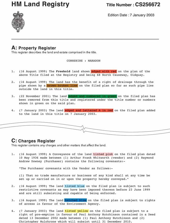
We normally show the land in a registered title by red edging on the title plan.
The red edging follows the inside of the line of the physical boundaries or the
plotted lines of undefined boundaries surrounding the property (see Examples
8 and 9). In exceptional circumstances, the edging may follow the outside of
the line or the land may be shown by pink colouring. These methods may be
used on very small areas of land, eg sites of walls, where the use of normal
edging is impractical. We also use pink colouring to show land on a caution
title plan.
Where an island of land is excluded from a title we will show it by green
colouring or hatching (see Example 9) and add a note of this exclusion to
the property register and the title plan.
Any parts removed from a title plan to another title will usually be edged with
green and the title number added in green (see Example 8). Another method
we use is green colouring without showing the new title numbers. In each case
we will add an explanatory note to the register and sometimes to the title plan.
Where a registration includes only part of a building, eg a room over a
passageway, we will make an explanatory note in the property register and
sometimes add a plans reference to the title plan. For clarification, we may
show complex floor levels on a supplementary plan that we prepare at a larger
scale and attach to the title plan.
Where the layout of the property is complex (eg multiple overlapping floor
levels) we may supplement a title plan with a deed which is referred to in the
property register.
For further information on title plans (see Public Guide 7 – Title plans).
5.4 Easements
Where possible, we make verbal descriptions of easements in the register
instead of plan references. We do this provided the subject matter described
(eg a passageway) is clearly identifiable on the title plan.
When a plan reference is necessary, we normally show the extent of beneficial
rights of way by brown colouring or brown hatching, and subjective rights of
way by blue colouring or blue hatching.
19Land Registry
Practice Guide 40
Oct 2005
It is helpful if the conventions mentioned in section 5.1 How we prepare title
plans, particularly with regard to rights of way, are followed when deed plans
are prepared. Where the colour references for rights of way on existing deeds
do not follow the conventions, we will reproduce the references shown in the
deed on the title plan where practicable.
The position of specific drainage rights granted by a deed are normally shown
on the title plan by a coloured broken line.
On developing estates, easements granted and reserved in individual deeds
by the vendor are likely to be similar. Such easements may include rights of
way over estate roads and common passageways, and rights of drainage.
The title plan of the vendor’s title will not show individual references for the
numerous rights of way and other easements of this kind to which the title is
subject. We make a general verbal entry in the register to cover such matters.
5.5 Measurements
We may show dimensions on the title plan only if they are shown on a deed
plan. These measurements do not determine the boundary’s exact line (see
section 3.3 Determined boundaries). We will not add dimensions to boundaries
that are already defined on the Ordnance Survey map, or to undefined boundaries
that are simply an extension of a solid line shown on the Ordnance Survey map.
Dimensions on a title plan or measurements in a register may be shown in
imperial or metric units or, in certain circumstances, both. The way they are
shown on a particular title or register will depend on:
— how they appeared in the derivative deed
— the date of the derivative deed
— the date they were added to the title plan or register
— whether they form part of a verbatim extract used on the register.
This is because, since 1995, metric units have been used. Prior to this date,
either imperial or metric units could be used.
Additionally, any qualifying words used such as “about” or “approximately”
will be reproduced on the title plan or in the register.
There has not been a wholesale conversion of any imperial measurements
appearing on title plans or registers created prior to 1995. Any request made
by a registered proprietor for measurements to be converted from imperial to
metric will normally be carried out without any fee. Any conversion of imperial
measurements is made precisely to four decimal places.
Where it is unavoidable to show metric and imperial dimensions together on
the same title plan, we make a warning note on the title plan stating that both
are shown.
5.6 Areas
Some Ordnance Survey maps on which the title plan is prepared may show
areas with a field or parcel number. This information has no special significance
in relation to the land in a registered title and we cannot guarantee that the
areas quoted are correct (see also section 5.1 How we prepare title plans).
5.7 Plans supplementary to the title plan
As stated in section 5.3 The land in a title, we sometimes show complex floor
levels on a supplementary plan or on an enlargement to the title plan. We also
sometimes use supplementary plans to show easements or covenants which
need a plan reference to clarify the register entry.
20Land Registry
Practice Guide 40
Oct 2005
5.8 Revision, replacement and amendment of the title plan
As a general rule, once a title plan has been prepared, we will only make an
amendment to the title boundary with the agreement of the registered proprietor
or as a result of a specific application. During the processes of registration it
sometimes becomes necessary to consider updating title plans in accordance
with the latest survey information. In these circumstances we may prepare a
new title plan and add a suitable note to the register. We call this replacing a
title plan.
We may also revise title plans to show later Ordnance Survey map information
where land has been sold from the title.
21Land Registry
Practice Guide 40
Oct 2005
Example 8
Title plan with extract of register
Note: The plan is a reduced copy of the original and has been reproduced for illustrative purposes only.
22Land Registry Practice Guide 40 Oct 2005 23
Land Registry
Practice Guide 40
Oct 2005

                    Example 9
                    Title plan with extract of register

                    Note: The plan is a reduced copy of the original and has been reproduced for illustrative purposes only.
24
Land Registry Practice Guide 40 Oct 2005 25
Land Registry
Practice Guide 40
Oct 2005

                    6 Requirements for identification of land to
                    be registered
                    6.1 Identification of land in deeds lodged for registration
                    Applications for first registration and transfers, or leases of part of the land in
                    registered titles are likely to require a plan to be attached to the appropriate
                    deed. All such applications should be supported by suitable plans (see sections
                    6.5 Plans for use in deeds and 6.7 Detailed plan requirements under Land
                    Registration Rules 2003). There are separate rules covering different types
                    of application (see sections 6.2 First registrations, 6.3 Transfers of part and
                    dispositionary leases and 6.4 Unusual land extents).

                    It is of the utmost importance that the land to be registered is described fully
                    and accurately in the deed inducing registration.

                    When drawing up a deed it is important to ensure that the plan and description
                    of the property are accurate and relate to the current state of the property.
                    Simply carrying forward an earlier property description may be misleading,
                    particularly if part of the land has already been sold. It is also important to
                    check whether any beneficial easements referred to in the property description
                    are still exercisable.

                    Any measurement quoted in a newly drawn deed must be in metres. An imperial
                    measurement may only be used as a supplementary indication if placed in
                    brackets after the metric measurement.

                    It is never necessary to specify the area of land in a deed.

                    6.2 First registrations
                    An application for first registration must be accompanied by sufficient details,
                    plan or otherwise, so that the land can be clearly identified on the Ordnance
                    Survey map.

                    In most cases a plan will be necessary. A verbal description may sometimes
                    be adequate, for example in the case of a house with a clear postal description
                    which is shown on the Ordnance Survey map with well established, fully defined
                    boundary features. A verbal description without a plan is inadequate if there is
                    any uncertainty about the land included (for example, where there are open
                    side passageways, open plan frontages, undefined rear gardens or a separate
                    garage/buildings).

                    See Examples 10 and 11.

26
Land Registry
Practice Guide 40
Oct 2005
Example 10
Properties not capable of being accepted for first registration without a plan
© CROWN COPYRIGHT. Produced by HMLR. Further reproduction in whole or part is prohibited without
the prior permission of Ordnance Survey.
© CROWN COPYRIGHT. Produced by HMLR. Further reproduction in whole or part is prohibited without
the prior permission of Ordnance Survey.
27Land Registry
Practice Guide 40
Oct 2005
Example 11
Properties which may be capable of being accepted for first registration
by postal address only
© CROWN COPYRIGHT. Produced by HMLR. Further reproduction in whole or part is prohibited without
the prior permission of Ordnance Survey.
Example 12
Extract from vendor’s/lessor’s title plan showing parts which may be
described in a transfer/lease without a plan ie the parts edged and
numbered 1, 2 and 3 in blue.
© CROWN COPYRIGHT. Produced by HMLR. Further reproduction in whole or part is prohibited without
the prior permission of Ordnance Survey.
28Land Registry
Practice Guide 40
Oct 2005
6.3 Transfers of part and dispositionary leases
A transfer of part or lease must always be accompanied by a plan unless the
land transferred or leased is clearly defined on the vendor’s/lessor’s title plan
and can be described verbally (see Example 12).
Where an approved estate plan exists, any plan used in the transfer/lease must
be based on the current approved version.
A verbal description referring to only plot numbers on an estate plan or to
a postal address is not acceptable.
The vendor/lessor must sign the plan to the transfer or lease. Where the
vendor/lessor is a company, the plan should be signed by officers of the
company with authority to sign on behalf of the company. The officers of the
company whose signatures appear in the form of execution at the end of the
transfer or lease itself can be be taken to have the necessary authority.
There are situations where we will reject any dealing of part or lease application
because of a defective plan. Further information is available in our Practice
Guide 49 – Rejection of applications for registration.
6.4 Unusual land extents
Unless all the land above and below the surface is included in an application,
a plan of the surface, on, under or over the land to be registered together with
sufficient information to define the vertical and horizontal extents must be
provided. For example, registration of cellars, flats or tunnels.
The plan requirements for any unusual application for registration are
fundamentally the same as for other applications (see sections 6.5 Plans for
use in deeds and 6.7 Detailed plan requirements under Land Registration
Rules 2003).
We are always prepared to advise on precise plan requirements for a specific
application. For further information, please contact the Customer Information
Centre at any Land Registry office.
6.5 Plans for use in deeds
Plans used in deeds originate from a variety of sources. Generally, any plan that
has been professionally prepared and is drawn accurately to a scale referred to in
section 6.7 Detailed plan requirements under LRR 2003, should be satisfactory
for use in a deed. Hand drawn sketches must not be used.
There are some occasions where a professionally drawn plan may be
unsuitable. For example, if it was drawn for an architectural or engineering
purpose (large scale) or it was drawn as a location plan or road map (small
scale). The most commonly acceptable plans for use in a deed are copy
Ordnance Survey maps or copy estate layout plans which we have approved.
Transfers and leases of part out of a new development MUST be accompanied
by a plan showing the land being dealt with and where an approved estate
plan exists, it must be based on the current approved version. A verbal
description by reference to plot numbers on the estate layout plan or the
postal address is not acceptable.
If the land does not have a clearly defined identity on the vendor’s title plan
(for example, an edging or number reference), a plan must be prepared for
the transfer of part or lease (see Example 11).
There are situations where we will reject any dealing of part or lease application
because of a defective plan. Further information is available in our Practice
Guide 49 – Rejection of applications for registration.
29Land Registry
Practice Guide 40
Oct 2005
6.6 Plans reduced in scale
Where it is clear that the plan contained in a deed or copy deed is a reduced
copy of the original, it is only acceptable provided either:
— the original scale has been deleted
— it has been endorsed with a statement to the effect that it is a reduced
copy (or in the case of a copy deed, a reduced copy of the plan to the
original deed), or
— the actual scale is stated in place of the original scale.
We will reject any dealing of part or lease application in respect of registered
land which contain plans that have been reduced from their original scale that
still bear the original scale endorsement. (See Practice Guide 49 – Rejection of
applications for registration).
Any plan attached to a certified copy of an original deed must not be
a reduced copy of the original. It must be identical to the original in all
respects.
6.7 Detailed plan requirements under LRR 2003
Where a plan is required for any new deed or for any application lodged at
Land Registry, it should be prepared having regard to the following guidelines.
— Drawn to and show its actual scale.
— Show its orientation (for example, a north point).
— Use preferred scales of 1/1250 – 1/500 for urban properties.
— Use preferred scales of 1/2500 for rural properties (fields and farms etc).
— Do not base on a scale of imperial measurement (for example 16 feet to
1 inch).
— Do not reduce in scale (see section 6.6 Plans reduced in scale).
— Do not mark or refer to as being for identification only.
— Do not show statements of disclaimer used under Property
Misdescriptions Act 1991.
— Show sufficient detail to be identified on the Ordnance Survey map.
— Show its general location by showing roads, road junctions or other
landmarks.
— Show the land of the property including any garage or garden ground.
— Show buildings in their correct (or intended) position.
— Show access drives or pathways if they form part of property boundaries.
— Show the land and property clearly (for example by edging, colouring
or hatching).
— Have edgings of a thickness that do not obscure any other detail.
— Show separate parts by suitable plan markings (house, parking space,
dustbin space).
— Identify different floor levels (where appropriate).
— Show intricate boundaries with a larger scale or inset plan.
— Show measurements in metric units only, to two decimal places.
— Show undefined boundaries accurately and where necessary, by reference
to measurements.
— Show measurements that correspond, so far as possible, to scaled
measurements.
We will reject any dealing of part or lease application in respect of registered
land where the plan to the deed bears a statement of disclaimer (see Practice
Guide 49 – Rejection of applications for registration).
6.8 Property descriptions
Any application for registration must contain a full description of the land to
be registered. All of the following details should be included wherever possible.
— Postal number or house name.
— Floor level.
— Road name.
— Locality.
30Land Registry
Practice Guide 40
Oct 2005
— Town.
— Administrative area.
— Postcode.
7 Inadequate identification of land
7.1 Differences between parcels and plans
An application should not contain any discrepancy between the parcels and
the plan in a recently executed deed.
Examples are where markings or colourings referred to in the deed do not
appear on the plan, or where the deed refers to a plan but no plan has been
attached. In these specific situations we will reject any dealing of part or lease
application in respect of registered land which contains either of these
discrepancies (see Practice Guide 49 – Rejection of applications for registration).
7.2 Poor quality plans
Difficulty will sometimes arise in identifying the land in an application. This
may be because:
— the plan cannot be related to the Ordnance Survey map
— the land is not clearly defined on the plan, eg by edging, colouring
or hatching
— markings used on the plan are badly drawn
— the plan is distorted, badly copied, or otherwise unclear.
In these situations we will either reject the application or raise a requisition.
Further information is available in our Practice Guide 49 – Rejection of
applications for registration. Where there is a problem of this nature affecting
an old deed we may ask for the parties to agree to a new plan. Alternatively,
we may carry out a survey or make other enquiries before seeking clarification
from the parties.
We normally deal with defective plans in modern transfers and leases by
requesting either that the existing plan is amended or a new plan is substituted
or the boundaries are altered where necessary. Where the plan is very large
or complex and the deficiency only relates to a small part of the boundary, we
may ask that the parties supply a separate plan endorsed with a statement to
the effect that it correctly shows the intention of the parties to the deed.
Whenever a deed plan is substituted or amended, it is essential that all parties
concerned in the transaction signify that the new plan correctly identifies the
land described in the deed.
7.3 Conveyances by description only
Where the land in a conveyance for first registration is identified by a verbal
description only and the land cannot be precisely identified on the Ordnance
Survey map, we may requisition for a plan to be supplied to show the land
intended to be conveyed (see section 6.2 First Registrations). Although an
extract from the relevant Ordnance Survey map may be supplied when this
type of requisition is made, it is stressed that we may still need to carry out
further investigations before title is approved.
7.4 Plans for identification purposes only
Plans described as “for identification purposes only” are not satisfactory for
land registration purposes.
Statements of disclaimer as described in section 6.7 Detailed plan requirements
under LRR 2003 are not acceptable.
31Land Registry
Practice Guide 40
Oct 2005
7.5 Completion of the title plan as an alternative to raising requisitions
In appropriate circumstances, as an alternative to raising requisitions, we may
prepare the title plan and send a letter to the applicant explaining that the
extent is different from the deeds and why.
Examples of situations where this may happen are where part of the land in
the application:
— clearly falls outside the occupied extent as shown on the latest Ordnance
Survey map and therefore appears to be occupied by another owner
— is already registered under another ownership.
Applicants may of course respond to the observations made in these letters.
8 Other plans related services
Copies of all of the practice guides mentioned below can be obtained from
any Land Registry office or downloaded from Land Registry’s website at
www.landregistry.gov.uk
8.1 Search of the index map service
Practice Guide 10 – Official searches of the index map explains how you can
find out whether a property is registered or not and, if so, its title number.
8.2 Title plan official copy service
Practice Guide 11 – Inspection and applications for official copies explains how
to obtain a copy of the title plan.
8.3 Developing estates – registration services
Practice Guide 41 – Developing estates – registration services with six
supplements deals with this topic. The supplements are:
Supplement 1: Estate boundary approval.
Supplement 2: Estate plan approval.
Supplement 3: Approval of draft transfers and leases.
Supplement 4: Plot sales – transfers and leases.
Supplement 5: Detailed plan requirements and specification – guidance
for surveyors.
Supplement 6: Voluntary application to note overriding interests.
8.4 Commonhold
Practice Guide 60 – Commonhold – section 4.3 The CCS plan gives details of the
requirements and specifications for commonhold community statement plans.
9 Enquiries and comments
If you have a particular concern which is not covered by this guide, please
contact Land Registry in advance of the transaction – see the Contact details
panel on the front cover of this guide. If the transaction is particularly complex,
it may be better if you make your enquiry in writing at the Land Registry office
which will process your application.
If you have any comments or suggestions about our guides, please send them to:
Registration Change Group
Land Registry
Lincoln’s Inn Fields
London
WC2A 3PH
(DX1098 London/Chancery Lane WC2).
32Land Registry
Practice Guide 40
Oct 2005
You can obtain further copies of this and of all our guides free of charge from
any Land Registry office or you can download them from our website at
www.landregistry.gov.uk
10 Forms and fees
You may buy any application forms you require or obtain a copy of the current
Land Registration Fee Order from any law stationer. Alternatively, you may also
download forms free of charge from our website. Details relating to fees are
also on our website and the full text of the Land Registration Fee Order will
be found on www.opsi.gov.uk/stat.htm
11 Appendix 1
Scale and accuracy of the Ordnance Survey map
11.1 Accuracy categories
The large scale Ordnance Survey map has been produced at various scales
using differing surveying methods resulting in varying levels of accuracy
being achieved.
There are four accuracy categories.
— 1:1250 scale.
— 1:2500 scale resurvey/reformed.
— 1:2500 scale overhaul. Maps originally recompiled from pre-1946 County
Series mapping.
— 1:10,000 scale.
Ordnance Survey describes accuracy in two ways.
— Relative accuracy – the position of a point in relation to another point
on a map.
— Absolute accuracy – the position of a point in relation to the Ordnance
Survey National Grid.
11.2 Relative accuracy
Relative accuracy is the comparison of the distance between features measured
on the ground to the corresponding information contained on the map.
Ordnance Survey publishes the following expected relative accuracy values
for well defined points within each accuracy category.
1:1250 Scale
If a ground measurement between two points is taken, up to a maximum
distance of 60m, there is a 99% chance that the equivalent distance on the
map will be represented within +/- 1.0 m.
1:2500 Scale resurvey/reformed
If a ground measurement between two points is taken, up to a maximum
distance of 100m, there is a 99% chance that the equivalent distance on the
map will be represented within +/- 2.3 m.
1:2500 Scale overhaul
If a ground measurement between two points is taken, up to a maximum
distance of 200m, there is a 99% chance that the equivalent distance on the
map will be represented within +/- 3.0m.
1:10,000 Scale
If a ground measurement between two points is taken, up to a maximum
distance of 500m, there is a 99% chance that the equivalent distance on the
map will be represented within +/- 8.8m. The 1:10,000 map also contains
33Land Registry
Practice Guide 40
Oct 2005
some generalisation of detail.
11.3 Absolute accuracy
Absolute accuracy is the measure which indicates how closely the coordinates
of a point in Ordnance Survey map data agree with the ‘true’ National Grid
coordinates of the same point on the ground. As the true position can never
be known exactly, the statistic is quoted relative to the best known position
determined by precise survey methods.
Ordnance Survey publishes the following expected absolute accuracy values
for well defined points within each category of mapping contained in the
National Topographic Database.
1:1250 Scale
The mapping of 99% of the points on the map can be expected to be within
1.0m of their true national grid position.
1:2500 Scale resurvey/reformed
The mapping of 99% of the points on the map can be expected to be within
2.4m of their true national grid position.
1:2500 Scale overhaul
The mapping of 99% of the points on the map can be expected to be within
6.0m of their true national grid position.
1:10,000 Scale
The mapping of 99% of the points on the map can be expected to be within
8.8m of their true national grid position.
The above information is reproduced with the kind permission
of Ordnance Survey.
12 Appendix 2
Legal presumptions
A presumption can be described as that which the law presumes about a
boundary in the absence of any evidence to the contrary which would rebut
it. The presumptions described below are the most commonly encountered.
Roadways
It is presumed that the boundary of land abutting a highway or private right
of way extends ad medium filum viae (to the middle of the way) subject, in the
case of the highway, to the rights of the highway authority. This presumption
is readily rebutted by conveyancing evidence showing contrary ownership.
A conveyance or transfer of land abutting a roadway is presumed to include
the roadway ad medium filum viae, even though it describes the land as
bounded by the roadway or includes a plan defining the land as excluding
the roadway. This presumption will be rebutted where there is evidence of
a contrary intention.
Hedge and ditch
Where two properties are divided by a hedge or bank and ditch, the boundary
is presumed to be along the opposite edge of the ditch from the hedge or
bank. This is based on the principle that an owner, standing on his boundary
looking inward, dug his drainage ditch within his boundary, threw up the soil
on his home side and then planted a hedge on the mound. This only applies
to man-made ditches and does not apply if it can be shown that the ditch is
natural or if it can be established that the boundary feature was made while
the lands on both sides were in common ownership.
34Land Registry
Practice Guide 40
Oct 2005
Rivers and streams, non-tidal
The boundary between properties abutting a natural non-tidal river or stream
is presumed to follow the centre line and the boundary changes if the course
of the stream changes naturally over a period of time – see also section 3.7
Accretion and diluvion.
Lakes
The bed of a lake belongs to the owner of the surrounding land if the lake
is entirely within the boundaries of a single ownership. Otherwise there is
no presumption.
Sea shore
The boundary of the land adjoining the sea lies at the top of the foreshore,
which is the land lying between the high and low water marks of a mean
average tide between spring and neap tides. The foreshore is owned by
the Crown unless it has been demised or granted. This also applies to land
bordering tidal rivers and inlets. As in the case of non-tidal rivers and streams
these boundaries may move gradually as the high water mark moves naturally
over the years but will not be effected by sudden movement.
35You can also read