Latrobe Valley Shallow Geothermal Project
←
→
Page content transcription
If your browser does not render page correctly, please read the page content below
Australian Geothermal Energy Conference 2011

                        Latrobe Valley Shallow Geothermal Project
                                          Driscoll, J.P.* & Beardsmore, G.R.
                                            jim.driscoll@hotdryrocks.com
                                                 Hot Dry Rocks Pty Ltd
                                         36 Garden Street, South Yarra, VIC 3141

The Latrobe Valley Shallow Geothermal Project
(LVSGP) aims to demonstrate fluid circulation and                  Introduction
heat extraction from moderate temperature                          Geothermal exploration aims to identify areas
groundwater resources at less than 1,000 m                         where the main components of a geothermal
depth in the Latrobe Valley and establish the                      system are present or can be engineered.
technical and commercial viability of this                         Namely: the availability of water, in situ permeable
renewable resource for small-scale electricity                     aquifers or rock units and elevated temperatures
production.                                                        at drillable depth.
Hot Dry Rocks Pty Ltd (HDR) undertook a                            Hot Dry Rocks Pty Ltd (HDR) is the operator of
Geothermal Systems Assessment (GSA) to                             the Latrobe Valley Shallow Geothermal Project
assess the potential for moderate temperature                      (LVSGP). The aim of the LVSGP is to install a
geothermal energy targets within the Morwell–                      500 kW (gross; 350 kW net) pilot electrical power
Traralgon area of the Latrobe Valley, onshore                      generator to demonstrate the potential of using
Gippsland Basin, Victoria. The principal risk areas                moderate temperature groundwater to generate
addressed in the GSA include the presence of an                    baseload electricity. The generator is being
adequate thermal insulating cover sequence                         developed and constructed by HDR’s partner in
(hence adequate temperatures for geothermal                        the LVSGP, Green Thermal Energy Technologies
prospectivity), the presence of a suitable reservoir               (gTET).
unit (a sedimentary aquifer), and the availability of
water.                                                             In November 2010 the Victorian Government’s
                                                                   Department of Primary Industries (DPI) awarded
Successful demonstration of the LVSGP will                         HDR a $217,500 grant under the Energy
translate to similar geological settings in Australia              Technology    Innovation    Strategy     (ETIS)
and overseas.                                                      Sustainable Energy Research & Development
Keywords: Latrobe Valley, Geothermal Systems                       (SERD 2) program to progress the LVSGP.
Assessment, Hot Sedimentary Aquifer                                A key element of this grant was a Geothermal
                                                                   Systems Assessment (GSA) of the coal-bearing

Figure 1: Location of the Latrobe Valley (background image courtesy of Google Earth).

                                                              53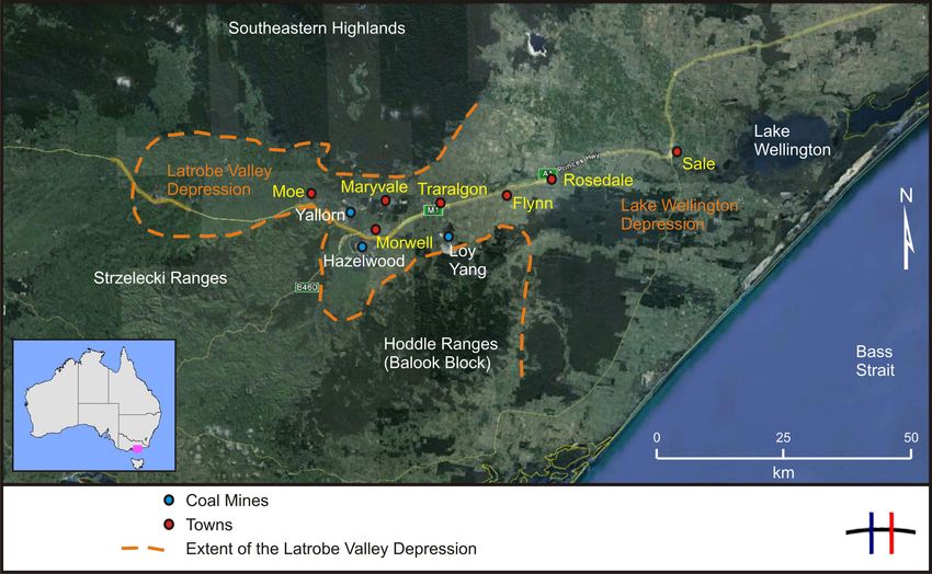
Australian Geothermal Energy Conference 2011

Figure 2: The GSA Framework as described by Cooper and Beardsmore (2008).

region of the Morwell–Traralgon area of the                   region. Strategically, the Latrobe Valley is the
Latrobe Valley. This assessment was primarily                 centre of Victoria’s electricity generating industry,
based on existing geotechnical datasets.                      supplying approximately 85% of Victoria’s
However,        HDR     undertook     a    Precision          electricity needs.
Temperature Logging (PTL) work program to
provide further data on the sub-surface                       The geothermal potential of coal-
temperature profile of key areas. A key                       bearing basins
deliverable of the GSA was to identify a preferred
                                                              The most prospective regions for high geothermal
site for the initial LVSGP exploration bore.
                                                              temperatures are those that have geological units
Since the LVSGP is targeting hot water shallower              of sufficiently low conductivity (high thermal
than 1,000 m, the project falls outside the                   resistance) in the cover sequence combined with
regulations of the Victorian Government’s                     high heat flow. Thick intervals of coal- and clay-
Geothermal Energy Resources Act (2005).                       rich sequences provide excellent thermal
However, the project is still subject to the usual            insulation properties; thus heat is trapped below
planning and environmental legislation and                    the sequences. Coal-rich sequences are also
regulation.                                                   commonly interbedded with sandstone horizons
                                                              that often have excellent reservoir characteristics,
Location                                                      such as high porosity and permeability. The
The study area of the GSA broadly covered the                 coincidence of elevated temperature and shallow
coal-bearing sequences of the onshore Gippsland               reservoirs makes an ideal geothermal energy
Basin,    Victoria—specifically  the   Morwell–               target.
Traralgon area of the Latrobe Valley (Figure 1),              Occurrences of relatively high temperature
located approximately 140 km ESE of Melbourne.                groundwater flowing at high yields from shallow
Brown coal resources are prevalent throughout                 depths in the Latrobe Valley are well known.
the Latrobe Valley, extending from Moe to                     Jenkin (1962) noted two bores with elevated
Rosedale, and include open-cut coal mines at Loy              temperatures in the Maryvale area, one of which
Yang, Hazelwood and Yallourn. These include                   recorded a well yield of 69.5 L/s at 70 °C from a
large coal resource areas yet to be allocated for             depth of 524.5 m.
development. The coal mining industry dominates
the Latrobe Valley landscape, both geographically
and politically, being a major employer in the

                                                         54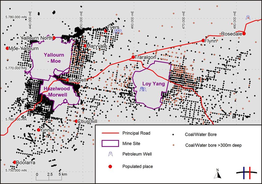
Australian Geothermal Energy Conference 2011

Geothermal Systems Assessment                                                  project.
The Geothermal Systems Assessment (GSA)                              The GSA methodology assesses each component
offers a holistic approach to delineating                            of the risk matrix, and places a confidence rating
geothermal resources with a methodology                              on the data used based on experience and
synonymous to that proposed by Magoon and                            current understanding of the area of interest.
Dow (1994) in their Petroleum Systems Analysis                       Some aspects of risk in the geothermal system
volume. The GSA framework (Figure 2), first                          share varying degrees of co-dependence. For
described by Cooper and Beardsmore (2008),                           example, heat flow and thermal resistance risk
addresses principle geological risks at basin or                     share a common link via rock thermal conductivity
tenement scale. Further detailed work at a play                      measurements.
scale is recommended to progress exploration in                      By understanding and quantifying the risk
areas that a GSA might highlight.                                    elements of each critical technical area, steps can
Four critical geothermal risk areas relate to four                   be taken to mitigate the risk prior to significant
geological factors. These are summarised below:                      expenditure (being proactive rather than reactive).
    1. Heat flow: Probability that heat flow                         For example, if heat flow is uncertain, it can be
        measurements or assumptions reliably                         measured prior to significant expenditure.
        characterise the play under investigation.
        Estimated from geographic coverage and
                                                                     Available data sets
        ‘uncertainty’ of heat flow estimates.                                                 Well data
    2. Thermal resistance: Probability that
        thermal resistance and heat transfer                         Many petroleum wells, coal bores and water
        mechanism beneath the level of well                          bores have previously been drilled within the
                                                                     Latrobe Valley (Figure 3).
        intersects are as assumed (purely
        conductive,      convective     component,                   Hydrogeological data were sourced from several
        advective component).                                        publications and included information such as
    3. Reservoir: Probability that reservoir                         groundwater models, well pump tests, and core
        properties and volumetric extent are as                      porosity and permeability estimates. However, the
        assumed. Estimated from geographic                           vast majority of hydrogeological data known to
        coverage, data type and reservoir type.                      exist for the region are non-published, proprietary
        Includes void connectivity and prevailing                    information not available for this study.
        stress regime.
    4. Water: Probability that water supply or                                             Seismic data
        chemistry will not adversely impact on the                   Seismic data in the Latrobe Valley are relatively

Figure 3: The geographical distribution of all petroleum wells and coal/water bores in the Latrobe Valley.

                                                                55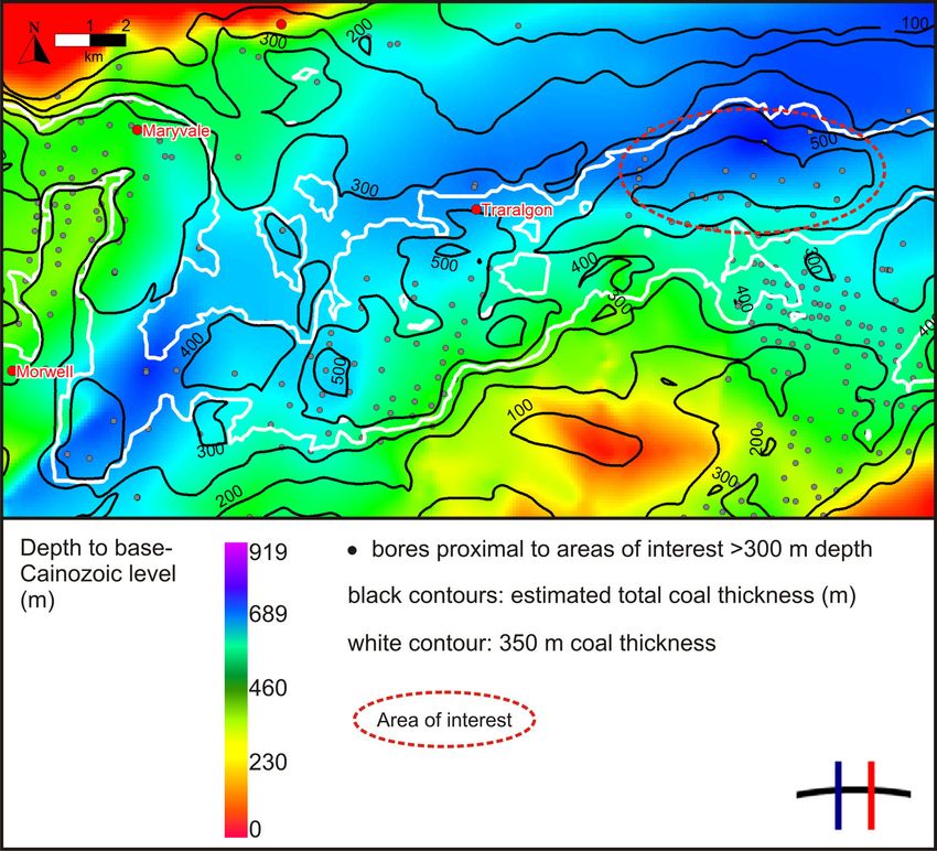
Australian Geothermal Energy Conference 2011

Figure 4: Location of seismic lines in the Latrobe Valley.
sparse with just four regional reflection seismic                 (~95 Ma) resulted in the Gippsland Basin
lines acquired in 1991 (Figure 4). The lines                      becoming a failed rift (Duddy, 2003; Webb et al.,
(GSG91A-01,         GSG91A-03,        GSG92A-2,                   2011).
GSG92A-3) have data to a depth of 3.8 seconds
                                                                  In the Late Neogene (~10 Ma) the Gippsland
TWT and are of reasonable quality, although
                                                                  Basin was subjected to tectonism and
quality deteriorates at depths greater than
                                                                  deformation associated with the Kosciuszko Uplift
1 second TWT, probably due to signal attenuation
                                                                  (Webb et al., 2011). This period of tectonism
through the Cainozoic coal succession. However,
                                                                  reactivated early rift features converting them to
a number of key reflections and faults beneath
                                                                  features of compression. Throughout the
this depth remain interpretable.
                                                                  Cainozoic post-rift failure, the Gippsland Basin
 Latrobe Valley Coal Measures 3D Model data                       became a rapidly subsiding sag basin (Holdgate,
                                                                  2005; Webb et al., 2011).
HDR was able to interrogate DPI’s 2003 Latrobe
Valley Coal Measures 3D Model to quantify the                     The Gippsland Basin covers 56,000 km², of which
depth to base Cainozoic and estimate the                          approximately 16,000 km² is situated onshore,
cumulative thickness of coal sequences in the                     and contains a succession of non-marine
area. DPI released a revised Latrobe Valley Coal                  Cretaceous to early Cainozoic sediments
Measures 3D Model in May 2011. The new model                      (Holdgate et al., 2000). A generalised cross
covered an expanded geographical area, included                   section of the onshore Gippsland Basin is
previously confidential datasets, and incorporated                presented in Figure 5.
geotechnical data collected between 2003 and
2011.                                                             Temperature Data
                                                                  One of the primary aims of a GSA is to quantify
Geology of the Latrobe Valley
                                                                  the value and uncertainty of the temperature of
The Gippsland Basin was formed during the                         key reservoir targets. Direct measurements of
Jurassic–Early Cretaceous continental breakup of                  temperature at the target depth are rarely
Gondwanaland in the initial phase of the rifting of               available for geothermal energy projects targeting
Australia from Antarctica (Duddy, 2003). During                   resources down to 5,000 m depth. However, the
this rifting E–W orientated en echelon grabens                    LVSGP is targeting shallow reservoirs previously
formed along southern Australia and rapidly filled                drilled at depths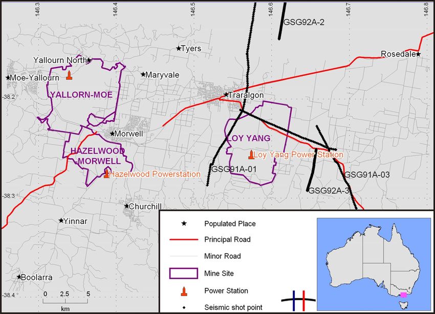
Australian Geothermal Energy Conference 2011

of pre-existing temperature datasets as they are                    Thermal resistance
usually collated for other purposes—most notably
petroleum exploration—and collected as ancillary                    Thermal resistance is the ‘blanket’ that traps heat
data.                                                               underground. It is synonymous with the ‘trap’ and
                                                                    ‘seal’ concepts of petroleum systems analysis.
Temperature data reported in petroleum and                          Thermal resistance (m2K/W) is the cumulative
coal/water bore reports are often of unknown                        sum of overburden thickness (m) divided by
quality. Petroleum ‘bottom hole temperature’                        thermal conductivity (W/mK). A geothermal
(BHT) are usually recorded a short time after the                   prospect must have an adequate ‘thermal blanket’
circulation of drilling fluid in a hole, and therefore              to retain heat at depth. This is best provided by a
represent disturbed thermal conditions. Likewise,                   thick sequence of low conductivity lithologies such
temperature logs collected immediately after                        as coals, carbonaceous shales or fine-grained
drilling has ceased in other types of bores are                     siltstones.
prone to similar errors.
                                                                    The Latrobe Valley hosts a world-class brown
Historical data from a number of boreholes in the                   coal deposit comprising up to five individual
Latrobe     Valley     suggest      that    elevated                seams, each in excess of 100 m. These thick
temperatures at shallow depths are a common                         multi-stacked     coal    units—the     Hazelwood
occurrence. Driscoll (2006) conducted a                             Formation,     Yallourn     Formation,     Morwell
geothermal assessment of Victoria and collated                      Formation and upper portions of the Traralgon
all published temperature data from boreholes                       Formation—are widely distributed throughout the
drilled in Victoria. A core component of that                       Latrobe Valley. HDR’s thermal conductivity
particular study was establishing the source of                     analysis in DPI’s Geothermal Atlas of Victoria
temperature data reported in earlier reports and                    (2010) confirmed the brown coal sequences
borehole completion reports. However, in many                       exhibit low conductivity and thus provide excellent
instances, the process of how and when data                         insulatory cover.
were collected could not be verified. Much of the
temperature data collected from coal and                            HDR calculated that approximately 350 m
petroleum reports are thus of unknown quality.                      cumulative thickness of coal would provide
This information is critical since well temperatures                insulation properties to achieve a 90 °C
measured during the drilling process can                            temperature.
underestimate the virgin rock temperature of the                    Given the plethora of geotechnical data
formations at depth.                                                confirming the thickness and lateral extent of thick
Discussions between HDR and a number of                             coal measures in the Latrobe Valley, the known
engineering and coal companies yielded further                      presence of elevated temperature in the Latrobe
temperature data that were only recently made                       Valley, and the directly measured thermal
available. However, once again, the details of how                  conductivity results from the coal measures, HDR
the data were recorded were not provided.                           is confident that thermal resistance poses a low
                                                                    risk.

Figure 5: Generalised cross section across the Latrobe Valley (modified from King et al. 1987).

                                                               57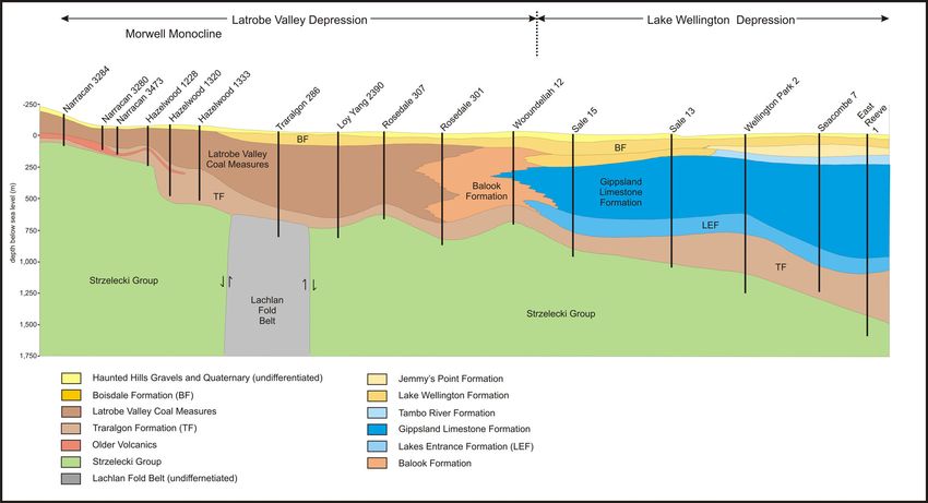
Australian Geothermal Energy Conference 2011
Figure 6: Contour of the 350 m cumulative coal isopach (white line) based on DPI’s 2011 Latrobe Valley Coal Measures 3D
Model, superimposed on an estimated depth to base-Cainozoic level (basement) colour grid in the Latrobe Valley (values
indicate metres below ground level). The areas with a purple hue indicate the thickest Cainozoic sequences. The main area of
interest delineated, based on the sedimentary succession thickness and cumulative coal thickness, is east of Traralgon.
abnormal climatic trends. Details of the selected
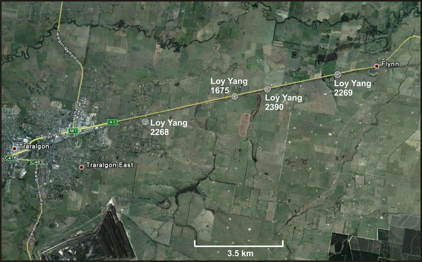
Precision Temperature Logging bores are included in Table 1 and Figure 7.
In light of the temperature data issues, HDR
undertook Precision Temperature Logging (PTL) Bore Number Logged Depth (m) Maximum
in late May 2011 to confirm prior reports of the Temperature (°C)
subsurface temperature regime. Loy Yang 1675 628.0 63.2
HDR interrogated DPI’s 2011 Latrobe Valley Coal Loy Yang 2268 439.9 52.2
Measures 3D Model to identify the most Loy Yang 2269 244.9 35.0
geologically favourable area for exploratory Loy Yang 2390 683.0 62.6
drilling, namely where the Cainozoic sedimentary
Table 1: Temperature data collected from the Precision
fill is thickest and where the cumulative coal
Temperature Logging work program.
measure thickness is greatest (Figure 6). The
most prospective area based on the geological Results
constraints was immediately east of Traralgon
The temperature profile from the Traralgon–Flynn
where the cumulative coal thickness was
area (Figure 8) were encouraging and showed a
predicted to exceed 350 m and the sedimentary
steep and steady increase with depth through the
fill equates to approximately 800 m.
coal-rich sequence.
Boreholes in excess of 300 m depth were
Loy Yang 1675 is shown in detail below as an
selected since shallower wells might be affected
example of further analysis of the PTL data.
by both diurnal and seasonal effects and by
Loy Yang 1675
58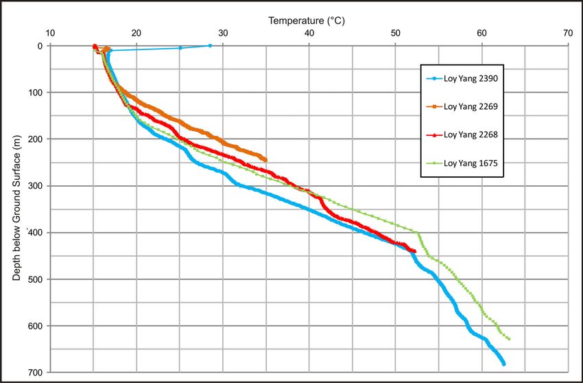
Australian Geothermal Energy Conference 2011

Figure 7: Precision Temperature Logging was performed on four bores in the Traralgon–Flynn area (background image
courtesy of Google Earth).
                                                                 sediment had been penetrated down to 628 m.
The precision temperature log and derived
                                                                 DPI’s 2003 Latrobe Valley Coal Measures 3D
thermal gradient log for Loy Yang 1675 are shown
                                                                 Model (Figure 6) had suggested over 350 m of
in Figures 9 and 10. Whilst the bore is 825 m
                                                                 coal-rich sediment would be penetrated at the
deep, our temperature probe met an obstruction
                                                                 bore site, and HDR thus initially anticipated that a
at 628 m, where a temperature of 63.2 °C was
                                                                 further ~100 m of coal might lie between 628 m
recorded, and was unable to descend any further.
                                                                 and 825 m. DPI subsequently supplied wireline
The temperature gradient log (Figure 10)                         logs for the Loy Yang 1675 bore down to a total
indicates approximately 250 m of coal-rich                       depth of 825 m. These logs include the Gamma

Figure 8: Precision Temperature Logs for the four Loy Yang bores.

                                                            59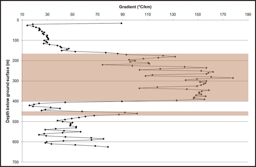
Australian Geothermal Energy Conference 2011

Figure 9: Precision Temperature Log for the Loy Yang 1675 bore. The maximum temperature of 63.2°C was recorded at 628 m.
Ray (GR) which can be used as a proxy for                        target isotherm and its indicative primary
delineating lithologies in a bore. The GR log                    porosities and permeabilities. The greatest
strongly suggested that the deeper stratigraphic                 uncertainty lies with its actual thickness, which
section comprises sandstone, siltstone and                       can strongly impact reservoir transmissivity.
carbonaceous mudstone rather than coal-rich                      Ideally, a reservoir thickness in the order of 100 m
lithologies. HDR therefore considered 350 m                      is required.
cumulative coal thickness unlikely. It is likely the
temperature at the base of the Cainozoic will be                 Working fluid
~75 °C at that location.                                         For the proposed geothermal plant, if the target of
Evidence from the other three Traralgon–Flynn                    100 L/s is sustained then the amount of fluid
bores suggested a similar geological scenario,                   cycled though the aquifer would be in the region
where the cumulative coal thickness interpreted                  of 3.2 GL/year. Existing hydrogeological evidence
from wireline logs is substantially less than the                (e.g. porosity, permeability) indicates that units of
2003 Latrobe Valley Coal Measures 3D Model                       the Traralgon Formation Aquifer System can act
suggests.                                                        as high-yielding aquifers.
                                                                 Across the entire onshore Gippsland Basin a
Reservoir
                                                                 significant long-term trend of declining water table
Reservoir risk has many guises, and is dependent                 levels has been recorded (GHD, 2010). However,
on the type of geothermal resource being                         the proposed geothermal electricity generation
targeted. In the case of the LVSGP, the target is a              operation will involve reinjection of the water in a
hot sedimentary aquifer (HSA). The key criteria                  ‘closed loop’ circuit and its potential impact in
for an HSA are porosity, permeability,                           terms of pressure effects are expected to be
transmissivity (i.e. permeability x aquifer                      contained to the local site (on the order of 100s of
thickness), storage and yield. These criteria                    metres radius). To properly evaluate potential
determine reservoir ‘deliverability’ and whether                 production/injection effects HDR intends to
sustainably high groundwater production and                      complete numerical aquifer modelling to simulate
injection flow rates can be achieved for an                      the response of the aquifer to the proposed
economically viable geothermal power plant. HDR                  production-injection scenarios over a 20-30 year
estimates that a flow rate of approximately                      operation life span.
100 L/s will be required for target production
                                                                 The Stratford Groundwater Management Unit
levels for the LVSGP.
                                                                 (GMU) covers          the LVSGP           groundwater
Within the study area the lowest technical                       resources. The Stratford GMU has been fully
reservoir risk lies with HSA targets of the                      allocated, thus HDR will be required to trade
Traralgon Formation. Favourable properties                       water entitlements if consumption of groundwater
include its likely existence below the minimal                   is necessary.

                                                          60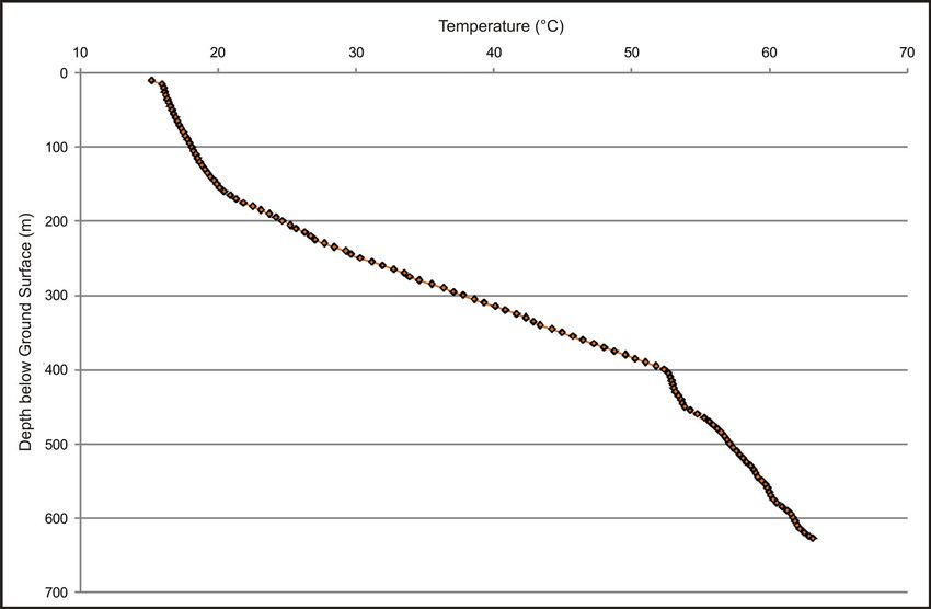
Australian Geothermal Energy Conference 2011

Figure 10: Temperature gradient profile of Loy Yang 1675. Brown shaded areas indicative of coal-rich sequences, at total
thickness of ~250 m.

                                                                       the 600–700 m target depth. The greatest
Results                                                                uncertainty lies with its actual thickness which
The GSA identified thermal resistance as the                           can strongly impact reservoir transmissivity. A
greatest risk in that the total coal thickness is                      reservoir thickness on the order of 100 m is
uncertain down to the base Cainozoic. To mitigate                      targeted.
this risk HDR chose to target an area with existing
                                                                   References
boreholes into the Traralgon Formation. A
productive HSA reservoir at a temperature of 70–                   Cooper, G.T. and Beardsmore, G.R., 2008.
75 °C is the lowest risk geothermal target within                  Geothermal systems assessment: understanding
the Cainozoic section of the Latrobe Valley.                       risks in geothermal exploration in Australia.
Existing borehole data suggest that such reservoir                 Proceedings of PESA Eastern Australasian
conditions occur in the vicinity of Maryvale.                      Basins Symposium III, Sydney 14–17 September,
                                                                   (2008), 411–420.
gTET is designing an optimal power generation
system for the LVSGP.                                              Department of Primary Industries (DPI)., 2003.
                                                                   Digital Geological Model of the Latrobe Valley
Conclusions                                                        Coal Resource. Geological Survey of Victoria
The principle findings of the LVSGP GSA are:                       Unpublished Report 2003/2 – Basic CD Package.
1. A lack of quality, reliable temperature data                    Department of Primary Industries                    (DPI).,
   from deep wells in the Latrobe Valley required                  Geothermal Atlas of Victoria.
   that HDR undertake precision temperature
                                                                   Department of Primary Industries (DPI)., 2011.
   logging (PTL).
                                                                   Digital Geological Model of the Latrobe Valley
2. The target geothermal resource for the                          Coal Resource. Geological Survey of Victoria.
   LVSGP is groundwater at 70–75°C from 600–
   700 m.                                                          Driscoll, J., 2006. Geothermal Prospectivity of
                                                                   Onshore Victoria, Australia. Victorian Initiative for
3. HDR considers the risk of insufficient                          Minerals and Petroleum Report 85, Department of
   reservoir temperature as low for the LVSGP                      Primary Industries. 88pp.
   since the target temperature has previously
   been intersected in a bore within the target                    Duddy, I.R., 2003. Mesozoic. In: Birch W.D. ed.
   depth interval and location.                                    Geology of Victoria, pp. 239-288. Geological
                                                                   Society of Australia Special Publications 23.
4. HDR considers the lowest technical reservoir
                                                                   Geological Society of Australia (Victoria Division).
   risk for the LVSGP to be the lower Traralgon
   Formation.     Favourable       porosity      and               GHD., 2010. Latrobe Valley regional groundwater
   permeability attributes are likely to exist within              and land level annual monitoring report, July 2008

                                                              61
Australian Geothermal Energy Conference 2011
to June 2009. Sourced January 2011: King, R.L., Ford, A.J., Stanley, D.R., Kenley, P.R.
http://groundwater.geomatic.com.au/Main.aspx. and Cecil, M.K., 1987. Geothermal Resources of
Victoria. Department of Industry Technology and
Holdgate, G.R., 2005. Geological processes that
Resources and Victorian Solar Energy Council.
control lateral and vertical variability in coal seam
134pp.
moisture contents-Latrobe Valley (Gippsland
Basin) Australia. International Journal of Coal Magoon, L.B. and Dow, W.G., 1994. The
Geology 63, 130–155. Petroleum System. In: Magoon, L.B. and Dow,
W.G. (Eds), The Petroleum System–from source
Holdgate, G.R., Wallace, M.W., Gallagher, S.J.
to trap, American Association of Petroleum
and Taylor, D., 2000. A review of the Traralgon
Geologists, Memoir 60, 3–24.
Formation in the Gippsland Basin – a world class
brown coal resource. International Journal of Coal Webb, J.A., Gardner, T.W., Kapostasy, D.,
Geology 45, 55–84. Bremar, K.A. and Fabel, D., 2011. Mountain
building along a passive margin: Late Neogene
Jenkin, J.J., 1962. Underground water in east
tectonism in southeastern Victoria, Australia.
Gippsland. Victorian Department of Mines
Geomorphology 125, 253–262.
Underground Water Investigation, Report 6.
62You can also read