Laveen Spectrum Planned Unit Development - City of Phoenix
←
→
Page content transcription
If your browser does not render page correctly, please read the page content below
City of Phoenix Rezoning Case Number: Z-12-20-7
Laveen
Spectrum

Planned Unit
Development
Approximate 71.75-gross acre project located
at the northwest corner of Baseline Road
and 59th Avenue along the Congressman Ed
Pastor / Loop 202 Freeway

First Submittal:
March 6, 2020
4th Submittal:
August 21, 2020
City Council Adopted:
November 4, 2020
PRINCIPALS &
   DEVELOPMENT TEAM
  BARCLAY GROUP                         GILA AND SALT RIVER
  Contact: Colby Fincham                DEVELOPMENT, LLC
  2415 East Camelback Road, Suite 900   Contact: Wes Lines
  Phoenix, Arizona 85016                2415 South Rural Road, Suite B
  (602) 224-4154                        Tempe, Arizona 85282
  cfincham@barclaygroup.com             (602) 540-1269
                                        weslines@msn.com

  RVI PLANNING & LANDSCAPE
  ARCHITECTURE
  Contact: Alex Stedman                 BUTLER HOUSING COMPANY
  120 South Ash Avenue                  Contact: Reid Butler
  Tempe, Arizona 85281                  42 West Maricopa Street
  (480) 994-0994                        Phoenix, Arizona 85013
  astedman@rviplanning.com              (602) 515-5031
                                        reid@butlerhousing.com

  GAMMAGE & BURNHAM
  Contact: Susan Demmitt                KIMLEY HORN
  40 North Central Avenue, 20th Floor   Contact: Traver Jones
  Phoenix, Arizona 85004                7740 North 16th Street #300
  (602) 256-4456                        Phoenix, Arizona 85020
  sdemmitt@gblaw.com                    (602) 994-5500
                                        traver-jones@kimley-horn.com

  SUSTAINABILITY ENGINEERING
                                        ARCHICON ARCHITECTURE &
  GROUP
  Contact: Ali Fakih                    INTERIORS
  8280 E. Gelding Drive, Suite 101      Contact: Jeff Koski
  Phoenix, Arizona 85260                5055 E. Washington Street, Suite 200
  (480) 588-7226                        Phoenix, Arizona 85034
  ali@azseg.com                         (602) 222-4266
                                        jeffk@archicon.com

LAVEEN SPECTRUM PUD Narrative                                                  2
TABLE OF CONTENTS
   1. PURPOSE AND INTENT				                      4
      1a. Planned Unit Development			             4
      1b. Project Overview and Goals			           4
      1c. Overall Design Concept			               6
   2. EXISTING SITE CONDITIONS			                 7
   3. DEVELOPMENT PLAN				                        9
       3a. Development Sub-Areas			               9
       3b. Phasing					                           11
   4. LAND USES						                             12
   5. DEVELOPMENT STANDARDS			                    16
       5a. Land Use Development Standards		       16
       5b. Landscape Zones				                    18
       5c. Landscape Development Standards        25
       5d. Parking Standards				                  28
       5e. Walls & Fences				                     28
       5f. Amenities					                         29
       5g. Pedestrian Circulation			              30
       5h. Bike Amenities				                     32
       5i. Screening					                         32
       5j. Lighting					                          33
   6. DESIGN GUIDELINES				                       34
       6a. Design Expectations				                34
       6b. Perimeter Design Corridor			           37
   7. SOUTHWEST GROWTH STUDY/LAVEEN
      GUIDE FOR DEVELOPMENT			                    38
   8. SIGNS						                                 40
   9. SUSTAINABILITY					                         42
      9a. Encouraged Sustainability Practices		   42
       9b. Existing Sustainability Practices 		   45
   10. INFRASTRUCTURE				                         48
      10a. Circulation					                       48
      10b. Grading & Drainage				                 49
      10c. Water & Wastewater				                 49
LAVEEN SPECTRUM PUD Narrative                          3
1. PURPOSE & INTENT
1a. Planned Unit Development
The Planned Unit Development (“PUD”) zoning district is authorized by Chapter 6, Section 671 of the Zoning
Ordinance of the City of Phoenix (“Phoenix Zoning Ordinance”). A PUD is intended to be a stand-a-lone
document that sets forth the regulatory framework, including permitted uses, development standards and
design guidelines, for a particular project (“PUD Regulations”). The PUD may only modify provisions within
the Phoenix Zoning Ordinance and does not modify other City of Phoenix codes, regulations or requirements.
A PUD may include substantial background information and narrative discussion, including purpose and
intent statements, which are intended to illustrate the overall character and vision for the development.
Such statements are not regulatory and are not requirements to be enforced by the City of Phoenix.

The PUD regulations apply to all property within the PUD project boundary. The PUD regulations supersede
and replace all applicable Phoenix Zoning Ordinance requirements. If there is a conflict between PUD
regulations and the Phoenix Zoning Ordinance, including the design guidelines within the Phoenix Zoning
Ordinance, the terms of this PUD shall apply. If a provision is not addressed by the PUD, then the Phoenix
Zoning Ordinance controls.

1b. Project Overview and Goals
The Laveen Spectrum PUD application seeks to rezone approximately 71.75 gross acres of land located at
the northwest corner of 59th Avenue and Baseline Road. See Figure 1 (Vicinity Map). The Applicant proposes
a mixed-use development consisting primarily of commercial, employment and high-density residential
uses.

The primary goal of the Laveen Spectrum PUD is to accommodate the development of a master planned
project that will complement the development and growth occurring along the Laveen Village’s Congressman
Ed Pastor / Loop 202 Freeway corridor. The Laveen Spectrum PUD will incorporate land uses and design
principles that create a cohesive mixed-use development environment.

The goals and objectives of the Laveen Spectrum PUD are to:

       • Master plan and create a multi-phased development consisting of a mix of uses and development
         options that will complement the area’s existing and planned development.

       • Capitalize on development opportunities along the recently opened Congressman Ed Pastor /
         Loop 202 Freeway.

       • Incorporate land use standards and design guidelines that create a cohesive place to live/stay,
         work and shop/play.

LAVEEN SPECTRUM PUD Narrative                                                                            4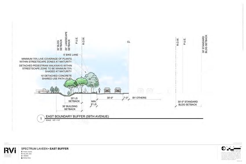
CONG
              RESS
                MAN
                                                                  Development
                                                                   Sub-Area 3
                    ED PA
                          STO
                         R / L
                               OOP
                                202 F
                                      REE

                                                                      Development

                                                                                           59TH AVENUE
                                                                       Sub-Area 2
                                            Pedestrian connections
                                     WAY

                                             between commercial
                                              uses to be evaluated.

Legend:
        Streetscape Zone
       Residential Zone
        Commercial Zone
       Project Gateway Zone
       Existing 6' Attached Concrete
       Sidewalk                                                                                          Project
       10' Detached Concrete                                                                             Gateway
       Shared Use Path                                                 Development
       10' Natural Surface Multi-Use
                                                                        Sub-Area 1
       Trail
       Proposed Pedestrian
       Connection to Development
       Sub-Areas
       Proposed Primary Vehicular                                          BASELINE ROAD
       Access
       Proposed Secondary
       Vehicular Access

                                                                                                                   SCALE: NTS

Figure 1:LAVEEN      SPECTRUM
          Vicinity Map                           FIGURE 7: PEDESTRIAN CIRCULATION PLAN
       PHOENIX, AZ

LAVEEN SPECTRUM PUD Narrative                                                                                                   5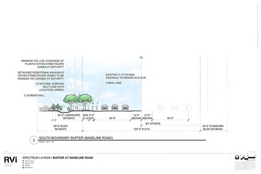
1c. Overall Design Concept
The Laveen Spectrum PUD provides the framework for a well-planned,
cohesive mixed-use project that integrates commercial, employment,
and residential uses into a connected and aesthetically unified
development. The Laveen Spectrum site is currently zoned for a mix
of commercial (C-2 HGT/WVR and C-1) and multifamily residential (R3-
A) uses. The goal of this PUD request is to generally maintain these
zoning districts and allowed uses while providing additional locational
flexibility for commercial, employment and high-density residential
uses across the site. Per Figure 2 (Conceptual Development Plan),
the southern 18.35 acres of the site (Development Sub-Area 1) is
planned exclusively for C-2 uses. The northern 17.95 acres of the site
(Development Sub-Area 3) is planned exclusively for R3-A uses. This is
generally consistent with the site's existing zoning entitlements. The
remaining 39.45 acres located in the center of the site (Development
Sub-Area 2) is planned to allow for both C-2 and R3-A uses. This flexibility
will generally allow for a transition of intensity from the commercial
and retail uses at the south end of the site to the residential uses at
the north end of the site. The additional flexibility within the central
development sub-area will allow the site to develop based on evolving
market needs within this area with uses that are compatible with the
site's location adjacent to the freeway corridor. All three development
sub-areas will be linked via multi-modal circulation routes along 59th
Avenue and Baseline Road. Streetscapes for these frontages will be
enhanced with street trees, shaded sidewalks, pedestrian nodes and
enhanced project gateways.

LAVEEN SPECTRUM PUD Narrative                                                  6
2. EXISTING SITE CONDITIONS
Laveen Spectrum consists of approximately 71.75 gross acres of property located at the northwest corner of
Baseline Road and 59th Avenue in the Laveen Village, within the municipal boundary of the City of Phoenix.
The site is comprised of two parcels, Maricopa County Assessor’s parcel numbers 104-86-001U and 104-
86-007A. See Appendix A (Legal Description). The site, which is generally flat and does not include any
significant topographical or natural features, currently accommodates the production of field crops.

To the west of the proposed development is the newly opened Congressman Ed Pastor / Loop 202 Freeway.
The freeway directly abuts the Laveen Spectrum site, with a full interchange at Baseline Road. The primary
travel lanes of the freeway are located approximately 200 feet from the site’s western property line providing
an adequate buffer for the project.

Uses and features adjoining or located in proximity to the Laveen Spectrum PUD property include:

       • The Laveen Park Place regional center, including Sprouts Farmers Market and Harkins Theatre,
         located immediately to the south across Baseline Road;

       • A future 11-acre commercial development located at the northeast corner of Baseline Road and
         the 59th Avenue alignment is planned to accommodate commercial uses and a church campus;

       • The currently closed Southern Ridge Golf Club located immediately to the east of the subject
         property across the 59th Avenue alignment;

       • The site of a future 43-acre Maricopa County Community College campus located immediately to
         the north;

       • Field crops, single-family residences and unimproved properties located in unincorporated
         Maricopa County to the west across the Congressman Ed Pastor / Loop 202 Freeway;

       • The Cottonfields residential neighborhood located east of the Southern Ridge Golf Club;

       • The Laveen Conveyance Channel located approximately 850 feet to the south and approximately
         1,300 feet to the east; and,

       • Betty H. Fairfax High School located approximately 1,000 feet to the southeast.

Table 1 (Surrounding Existing Uses) identifies the existing land uses surrounding the site.

LAVEEN SPECTRUM PUD Narrative                                                                               7
TABLE 1: SURROUNDING EXISTING USES
Location                 General Plan                     Zoning                   Land Use
Site                     Commercial and 10-15             C-2, HGT/WVR, C-1 and    Agricultural (field
                         du/acre – Higher density         R-3A                     crops)
                         attached townhouses,
                         condos or apartments
North                    3.5 to 5 du/acre - Traditional   S-1 (Approved R3-A and   Agricultural (field
                         Lot                              R1-8)                    crops)
East and Northeast       Parks/Open Space                 C-1 and GC               Southern Ridge Golf
(across 59th Avenue                                                                Club (closed) and
alignment)                                                                         unimproved
Southeast (across        10 to 15 DU/Acre – Higher        S-1 (approved C-2)       Unimproved
59th Avenue and          Attached Townhouses,
Baseline Road)           Condos, or Apartments
South        (across     Commercial – Commerce/           Mixed Use (Commercial/   Laveen Park Place
Baseline Road)           Business Park                    Commerce/Business        regional center,
                                                          Park)                    including Sprouts
                                                                                   Farmers Market and
                                                                                   Harkins Theatre
Southwest (across        Mixed Use (Commercial/           CP/GCP                   Agricultural (field
Baseline Road and        Commerce/Business Park)                                   crops)
Loop 202 Freeway)
West         (across     0-1 Du/Acre – Large Lot          Maricopa County RU-43    Agricultural (field
Loop 202 Freeway)        Residential                      & C-2                    crops), single family
                                                                                   residences and
                                                                                   unimproved
Northwest (across 0-1 Du/Acre – Large Lot                 Maricopa County RU-43    Single-family
Loop 202 Freeway) Residential                                                      residences

LAVEEN SPECTRUM PUD Narrative                                                                              8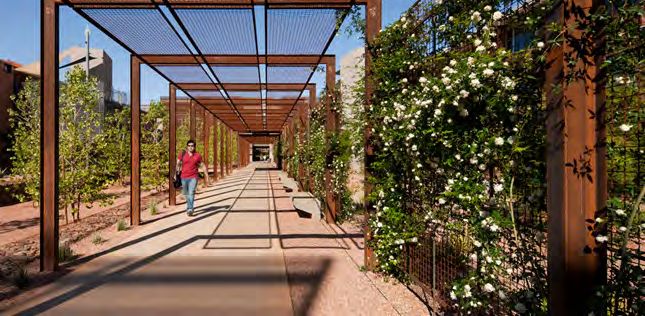
3. DEVELOPMENT PLAN
The conceptual design framework for Laveen Spectrum incorporates three (3) development sub-areas. See
Figure 2 (Conceptual Development Plan). Development standards and uses have been identified for each
sub-area to establish a cohesive design approach for the property while providing flexibility in land use
within each development district. The specific uses developed within each sub-area will be determined by
future market demand. The more intense, retail-oriented uses are planned adjacent to Baseline Road and
in proximity to the Congressman Ed Pastor / Loop 202 Freeway on-ramp with uses generally transitioning
in intensity from commercial and retail uses to higher density residential uses as the project moves north
away from these thoroughfares. While the Conceptual Development Plan identifies the boundaries of each
planned development sub-area, uses may be developed across sub-area boundaries so long as the use is
allowed in both sub-areas.

3a. Development Sub Areas
DEVELOPMENT SUB-AREA 1
Development Sub-Area 1 is approximately 18.35 gross acres in size and is located adjacent to Baseline Road
at the southern edge of the property. Given its location along this major thoroughfare and its proximity to
the Congressman Ed Pastor / Loop 202 Freeway on-ramp, this sub-area is a prime location for commercial
retail uses. Vehicular access to this sub-area will be from both Baseline Road utilizing existing driveway
improvements, and from 59th Avenue. The development standards and allowed uses designated for this
parcel support a range of commercial development typically aligned with the City of Phoenix’s C-2 zoning
category.

DEVELOPMENT SUB-AREA 2
Development Sub-Area 2 is approximately 35.54 gross acres in size, located at the center of the property and
is planned to support a mix of commercial and residential uses. This sub-area takes direct access from 59th
Avenue and may include internal pedestrian connections between commercial uses in Sub-Areas 1 and 2.
Due to the centralized location of Sub-Area 2 and the lack of exposure to Baseline Road, planned uses within
this sub-area may be more diversified than the retail-intensive commercial planned for Sub-Area 1. Examples
of uses envisioned for Development Sub-Area 2 include a hotel, park and ride facility, medical offices, self-
storage, general office uses, and a mix of multifamily or single family housing as generally allowed under
the current C-2 zoning, including but not limited to: detached single-family homes, detached built-to-rent
units, townhomes, condominiums, apartments, independent senior living and assisted living units.

DEVELOPMENT SUB-AREA 3
Development Sub-Area 3 is approximately 17.95 gross acres in size and is planned to support a variety of
residential development types. This sub-area is likely to be developed in phases with a mix of residential
housing. Examples of types of housing that could develop within Sub-Area 3 include but are not limited
to detached single-family homes, detached build-to-rent units, townhomes, condominium, apartments,
independent senior living, and assisted living units.

LAVEEN SPECTRUM PUD Narrative                                                                              9
CONG
                   RESS
                       MAN
                                                                                   Development
                                                                                    Sub-Area 3
               CONG
                 ED PA

                                                                                Development
                                                                                 Sub-Area 3
                      RESS

                       STOR
                           MAN

                            / LOO
                                ED PA

                                  P 202
                                      STOR

                                        FREE

                                                                                      Development

                                                                                                                       59TH AVENUE
                                                                                       Sub-Area 2
                                           / LOO

                                                                  Pedestrian connections
                                             WAY

                                                                   between commercialDevelopment
                                                                    uses to be evaluated.

                                                                                                         59TH AVENUE
                                                                                    Sub-Area 2
                                                 P 202

Legend:
          Streetscape Zone
                                                       FREE

          Residential Zone
          Commercial Zone
                                                            WAY

          Project Gateway Zone
          Existing 6' Attached Concrete
          Sidewalk                                                                                                                   Project
                                                                                                                                     Primary
          10' Detached Concrete                                                                                                      Gateway
                                                                                                                                     Entry
          Shared Use Path                                                              Development
          10' Natural Surface Multi-Use
                                                                                        Sub-Area 1
          Trail
                                                                                     Development                                     Secondary
          Proposed Pedestrian                                                         Sub-Area 1                                     Entry
          Connection to Development
          Sub-Areas
          Proposed Primary Vehicular                                                        BASELINE ROAD
          Access
          Proposed Secondary
          Vehicular Access                                                               BASELINE ROAD

                                                                                                                                               SCALE: NTS

          LAVEEN SPECTRUM                FIGURE 7: PEDESTRIAN CIRCULATION PLAN
Figure 2: Conceptual Development Plan
          PHOENIX, AZ
Note:: Figures                                                                                                              SCALE:
               are provided for conceptual purposes only. Project details, including access point locations, will be solidified    NTS the
                                                                                                                                during
Preliminary Site Plan Review process.
           LAVEEN SPECTRUM                 FIGURE 2: CONCEPTUAL DEVELOPMENT PLAN
           PHOENIX, AZ

LAVEEN SPECTRUM PUD Narrative                                                                                                                               10
3b. Phasing
CONG
Laveen Spectrum is a multi-phase development. Development of Sub-Area 1 and its associated infrastructure
is anticipated as the first phase of development, with Development Sub-Areas 2 and 3 anticipated to follow
subject to market conditions. See Figure 3 (Conceptual Phasing Plan).
RESS
MAN
Development
Sub-Area 3
ED PA
C OSNT G
Development
ORRE /
Sub-Area 3
S SL M
OO
A NP E2 0 2
D PF AR
SE
Development
TO
59TH AVENUE
Sub-Area 2
EW
Pedestrian connections
R A/ YL
between commercial
uses to be evaluated.
OOP
Development
Legend:
59TH AVENUE
Sub-Area 2
Streetscape Zone
202 F
Residential Zone
REE
Commercial Zone
Project Gateway Zone
WAY
Existing 6' Attached Concrete
Sidewalk Project
10' Detached Concrete Gateway
Shared Use Path Development
10' Natural Surface Multi-Use
Sub-Area 1
Trail
Proposed Pedestrian Development
Connection to Development Sub-Area 1
Sub-Areas
Proposed Primary Vehicular BASELINE ROAD
Access
Proposed Secondary
Legend:
Vehicular Access BASELINE ROAD
Phase 1
Future Phases SCALE: NTS
Figure 3: Conceptual
LAVEEN SPECTRUM Phasing PLan FIGURE 7: PEDESTRIAN CIRCULATION PLAN
Note:: Figures
PHOENIX, AZ are provided for conceptual purposes only. Project details, including access point locations, will beSCALE:
solidified
NTS during
the Preliminary Site Plan Review process.
LAVEEN SPECTRUM FIGURE 3: CONCEPTUAL PHASING PLAN
LAVEEN SPECTRUM PUD Narrative 11
PHOENIX, AZ4. LAND USES
This section defines the land uses allowed within the Laveen Spectrum
PUD. Land uses have been specifically identified for each of the
PUD’s three development sub-areas and are subject to the specified
requirements and development standards. A developer or any
property owner within the defined limits of the PUD may request an
interpretation of a use analogous to those listed in this section from
the City of Phoenix Zoning Administrator. The Zoning Administrator
may administratively approve a use analogous to those listed in this
section subject to standard and customary City of Phoenix procedures.
Temporary uses are permitted within the Laveen Spectrum PUD in
accordance with Zoning Ordinance Section 708.
DEVELOPMENT SUB-AREA 1
(SOUTHERN SUB-AREA)
Uses allowed within Development Sub-Area 1 include:
• All uses permitted in the C-2 (Intermediate Commercial)
District per Zoning Ordinance Section 623, except that multi-
family dwellings and single-family dwellings, attached and
detached, are prohibited.
The following additional uses are allowed by right within Development
Sub-Area 1:
• Community Garden
• Farmer’s Market
• Agricultural Crops: raising, harvesting and indoor/outdoor
retail sales
• Private commercial fishing ponds
The following accessory uses are allowed by right within Development
Sub-Area 1:
LAVEEN SPECTRUM PUD Narrative 12• Outdoor recreation uses, outdoor dining and/or outdoor alcoholic beverage consumption as an
accessory use to a restaurant, subject to the following conditions when the above-mentioned use
is located within 150-feet of existing residential development (measured from property lines):
◦ Seating areas are oriented away from existing residential development or screened by a
minimum 30-foot wide landscape area.
• Drive-through facilities as an accessory use to a restaurant, subject to location and design
requirements specified by Zoning Ordinance Section 702.B.6. In addition to the location and
design requirements specified by Zoning Ordinance Section 702.B.6, drive-through facilities as
an accessory use to a restaurant are also subject to the following when located within 150-feet of
existing residential development (measured from property lines):
◦ Menu boards and speakers are to be oriented away from existing residential development or
screened by a minimum 30-foot wide landscape area.
◦ Outdoor lighting shall be shielded to reduce light spillage onto adjacent residential properties
◦ Hours of operation for the drive-through service shall be limited from 7:00 a.m. to 11:00
p.m. daily. If the use is located greater than one hundred fifty (150' 0") feet from an existing
residential development, then there are no restrictions on the hours of operation. The
designated approving authority may grant exceptions through a use permit.
DEVELOPMENT SUB-AREA 2
(CENTRAL SUB-AREA)
Uses allowed within Development Sub-Area 2 include the following:
• All uses permitted in the C-2 (Intermediate Commercial) District per Zoning Ordinance Section 623
• All uses permitted in the R-3A (Multifamily Residence) District
per Zoning Ordinance Section 616
The following additional uses are allowed by right within Development
Sub-Area 2:
• Self-Service Storage Warehouses, subject to the following
conditions:
◦ The Self-Storage Warehouse use area shall not exceed
five (5) net acres in size;
◦ All storage shall be within a closed building except
that boats, trailers and motor vehicles may be placed
in outdoor storage areas which are separate from the
buildings and screened from view from adjacent streets
and property by walls, fences or landscaping; and,
◦ Outdoor storage areas shall not exceed 10% of the gross
site area.
LAVEEN SPECTRUM PUD Narrative 13• Park and Ride Facility, subject to the following condition:
◦ Shall not exceed five (5) net acres in size
• Community Garden
• Farmer’s Market
• Agricultural Crops: raising, harvesting and indoor/outdoor retail sales
• Private commercial fishing ponds
The following accessory uses are allowed by right within Development Sub-Area 2:
• Outdoor recreation uses, outdoor dining and/or outdoor alcoholic beverage consumption as an
accessory use to a restaurant, subject to the following conditions when the above-mentioned use
is located within 150-feet of existing residential development (measured from property lines):
◦ Seating areas are oriented away from existing residential development or screened by a
minimum 30-foot wide landscape area.
• Drive-through facilities as an accessory use to a restaurant, subject to location and design
requirements specified by Zoning Ordinance Section 702.B.6, subject to the following conditions
when the above-mentioned use is located within 150-feet of existing residential development
(measured from property lines):
◦ Menu boards and speakers are to be oriented away from existing residential development or
screened by a minimum 30-foot wide landscape area.
◦ Outdoor lighting shall be shielded to reduce light spillage onto adjacent residential properties
◦ Hours of operation for the drive-through service shall be limited from 7:00 a.m. to 11:00
p.m. daily. If the use is located greater than one hundred fifty (150' 0") feet from an existing
residential development, then there are no restrictions on the hours of operation. The
designated approving authority may grant exceptions through a conditional use permit after
preparation of a qualified noise study.
LAVEEN SPECTRUM PUD Narrative 14DEVELOPMENT SUB-AREA 3
(NORTHERN SUB-AREA)
Uses allowed within Development Sub-Area 3 include the following:
• All uses permitted in the R-3A (Multifamily Residence) District
per Zoning Ordinance Section 616
• Assisted living center, as defined by Section 36-401 of the Arizona
Revised Statutes
• Community Garden
• Farmer’s Market
• Agricultural Crops: raising, harvesting and indoor/outdoor retail
sales
• Private commercial fishing ponds
LAVEEN SPECTRUM PUD Narrative 155. DEVELOPMENT STANDARDS 5a. Land Use Development Standards Development Standards guide development and protect surrounding neighborhoods and preserve the public welfare. The development standards for each of the three development sub-areas within Laveen Spectrum generally adhere to the development standards outlined within the City of Phoenix Zoning Ordinance. The following identifies the development standards that apply to each of the three development sub- areas. Table 2 (Development Standards) identifies the minimum Development Standards prescribed for Laveen Spectrum’s three Sub-Areas. Within Development Sub-Area 1 and for commercial uses within Development Sub-Area 2, C-2 (Intermediate Commercial - Zoning Ordinance Section 603) District standards shall apply except for as noted within Table 2 below. Within Development Sub-Area 3 and for residential uses within Development Sub-Area 2, R3-A (Multifamily Residence – Zoning Ordinance Section 616) District standards shall apply except for as noted within Table 2 (Development Standards). LAVEEN SPECTRUM PUD Narrative 16
TABLE 2: DEVELOPMENT STANDARDS
                                 Development              Development Sub-Area 2              Development
                                    Sub-Area 1                                                   Sub-Area 3
      Applicability             All Permitted Uses   All Uses Permitted All Residential Uses All Permitted Uses
                                                        in C-2 Zoning    Permitted in R-3A
                                                     District, Excluding   Zoning District
                                                      Residential Uses
   Building Setbacks
  Adjacent to Baseline               50-feet               N/A                  N/A                 N/A
          Road:
 Adjacent to 59th Ave.:              30-feet              30-feet             20-feet             20-feet
  Adjacent to freeway                15-feet              15-feet             20-feet             20-feet
        frontage:
Not Adjacent to a public             10-feet              10-feet             20-feet             20-feet
          Street:
 Perimeter Landscape
       Setbacks
  Adjacent to Baseline          Avg. 50-feet, Min.         N/A                  N/A                 N/A
          Road:                      30-feet
 Adjacent to 59th Ave.:              20-feet              20-feet             20-feet             20-feet
 Adjacent to freeway                 15-feet              15-feet             15-feet             15-feet
       frontage:
Not Adjacent to a public             10-feet              10-feet            10-feet*             10-feet*
         Street:
 Max. Building Height:               56-feet              56-feet             48-feet             48-feet
    Min. Open Space:            Dev. Sub-Area -      Dev. Sub-Area -      Dev. Sub-Area -     Dev. Sub-Area -
                                10% of net area      10% of net area      10% of net area     10% of net area

                            Dev. Parcel** – 7% Dev. Parcel** – 7% Dev. Parcel** – 7% Dev. Parcel** – 7%
                               of net area        of net area       of net area***     of net area***

*No perimeter landscape setback is required where private yards within a detached multi-family development
(such as single-family for rent) are located adjacent to a perimeter property line provided that a minimum 10’
depth for a private yard must be provided.

**For the purpose of determining open space requirements for any individual development project within a
Development Sub-Area, a Development Parcel shall be considered the limits of an individual development
project as shown by the boundaries included on a Preliminary Site Plan.

*** Residential uses with densities not exceeding 14 units per gross acre shall have a minimum of 15% open
space based on net site area.

LAVEEN SPECTRUM PUD Narrative                                                                                    17
5b. Landscape Zones
The Laveen Spectrum PUD encompasses a variety of zones and uses,
each with unique landscape needs. Landscape zones have been
designated for each area of the site and are defined by their individual
landscape development standards, theming and plant palettes to
establish a cohesive visual language among all areas of the site. Figure
4 (Landscape Zones Plan) identifies the general location of each
landscape zone. The five landscape zones employed across the Laveen
Spectrum development include:
• Streetscape Zone
• Perimeter Buffer Zone
• Residential Zone
• Commercial Zone
• Project Gateways
LAVEEN SPECTRUM PUD Narrative 18CONG
RESS
MAN
Development
Sub-Area 3
CONG
ED PA
Development
Sub-Area 3
RESS
STOR
MAN
/ LOO
ED PA
P 202
STOR
FREE
Development Project
Gateway
59TH AVENUE
Sub-Area 2
/ LOO
Pedestrian connections
WAY
between commercialDevelopment
uses to be evaluated.
59TH AVENUE
Sub-Area 2
P 202
Legend:
Streetscape Zone
FREE
Residential Zone
Commercial Zone
WAY
Project Gateway Zone
Existing 6' Attached Concrete
Sidewalk Project
Primary
10' Detached Concrete Gateway
Entry
Shared Use Path Development
10' Natural Surface Multi-Use
Sub-Area 1
Trail
Development Secondary
Proposed Pedestrian Sub-Area 1 Entry
Legend:
Connection to Development
Sub-Areas
Streetscape Zone
Proposed Primary Vehicular BASELINE ROAD
Access
Perimeter Buffer Zone
Proposed Secondary
Residential Zone
Vehicular Access BASELINE ROAD
Commercial Zone
Project Gateway Zone SCALE: NTS
Figure 4: LAVEEN
Landscape SPECTRUM
Zones Plan FIGURE 7: PEDESTRIAN CIRCULATION PLAN
Note:: Figures are provided
PHOENIX, AZ for conceptual purposes only. Project details, including access point locations, will be solidified during
SCALE: NTS
the Preliminary Site Plan Review process.
LAVEEN SPECTRUM FIGURE 4: LANDSCAPE ZONES PLAN
PHOENIX, AZ
LAVEEN SPECTRUM PUD Narrative 19STREETSCAPE ZONE Baseline Road and 59th Avenue will be identified by their thematic streetscape treatment. This area consists of an average 50-foot, minimum 30-foot wide landscape buffer along Baseline Road, in conformance with the Baseline Road Scenic Drive standards contained in the Laveen Southwest Growth Study, and a minimum 20-foot wide landscape buffer along 59th Avenue. These streetscape areas will be landscaped to provide an attractive softened project edge. Enhanced planting densities and caliper sizes will promote an attractive visual experience along the site’s perimeter street frontage. Trees are required to be planted on both sides of all detached pedestrian pathways to create an interesting, comfortable and shaded pedestrian environment. Enhanced pedestrian amenities, as defined within Table 3 (Landscape Development Standards), are required to be provided at a rate of one (1) per development sub-area arterial frontage. Streetscape Zones should have themed street trees and a tailored landscape appearance. To emphasize and tie into the agrarian nature of the surrounding area, landscape and hardscape elements should use an agrarian vernacular in the form of linear and green planting elements. Figure 5 (Streetscape Details) provides graphic representations of these thematic streetscape areas. PERIMETER BUFFER ZONE Perimeter buffers are located along the project’s north and west perimeter property lines. These areas are less visible from surrounding properties. Plantings in these areas will be low maintenance and drought tolerant. Plant species with large forms should be provided along the freeway frontage / west perimeter to ensure that species are highly visible as to soften the project edge. LAVEEN SPECTRUM PUD Narrative 20
RESIDENTIAL ZONE
Residential areas should feature high-density plantings with enhanced landscaping along the perimeter
of buildings and around amenity areas. Landscaping for residential areas should be colorful and include
a variety of plants that create seasonal interest. The focus should be on drought-tolerant plants that are
adapted to the Arizona climate, but turf, palms and other higher-water use plant materials may be used in
moderation particularly at entries and within amenity areas.

COMMERCIAL ZONE
Commercial development within the site shall include low maintenance, drought-tolerant plants. Planting
patterns around the building perimeter will reinforce a structured agrarian theme and be placed in geometric
orientations. Raised planter pots, trellising systems, and/or other landscape and hardscape enhancements
may be utilized as well. Building entries will feature more dense, lush planting. Plant materials should not
cover tenant signage and should reflect the character of the architecture. Plants selected for parking lot
landscape are to be heat adapted and well-maintained to promote upright growth patterns and shade
provision.

LAVEEN SPECTRUM PUD Narrative                                                                            21
PROJECT GATEWAYS
While the Laveen Spectrum development will have multiple access points off Baseline Road and 59th
Avenue, select entries have been conceptually identified on Figure 4 (Landscape Zones Plan) to serve
as project gateways and receive enhanced landscape treatments. These enhanced project gateways
will be the primary access points to the site and will announce key arrival points throughout the project
showcasing Laveen Spectrum’s aesthetic language. The specific location of Project Gateways will be
determined during the Preliminary Site Plan review and approval process; however, at a minimum, Sub-
Area 1 will have one Project Gateway each along Baseline Road and 59th Avenue and Sub-Areas 2 and 3 will
have one Project Gateway each. Project gateways shall be clearly identified as project entrances through
the use of enhanced landscape and hardscape treatments. These shall include increased plant densities,
themed plant species, as well as architecturally themed monument signage and site walls and fences.
Landscape plantings shall consist of specimen trees, mass plantings of evergreen and flowering shrubs,
groundcover, and accent plantings. Vertical accents, such as Date Palms, monument signage, decorative
light fixtures or other vertical landscape elements, should be used for wayfinding and to highlight these
key gateways and entries. Enhanced surfacing materials (e.g. stamped or colored concrete) and other
textural or tactile improvements such as, but not limited to, the use of seating nodes, enhanced signage,
and elevated landscape materials shall be used to signify project entries and to promote safe pedestrian
circulation within these busy areas.

LAVEEN SPECTRUM PUD Narrative                                                                          22
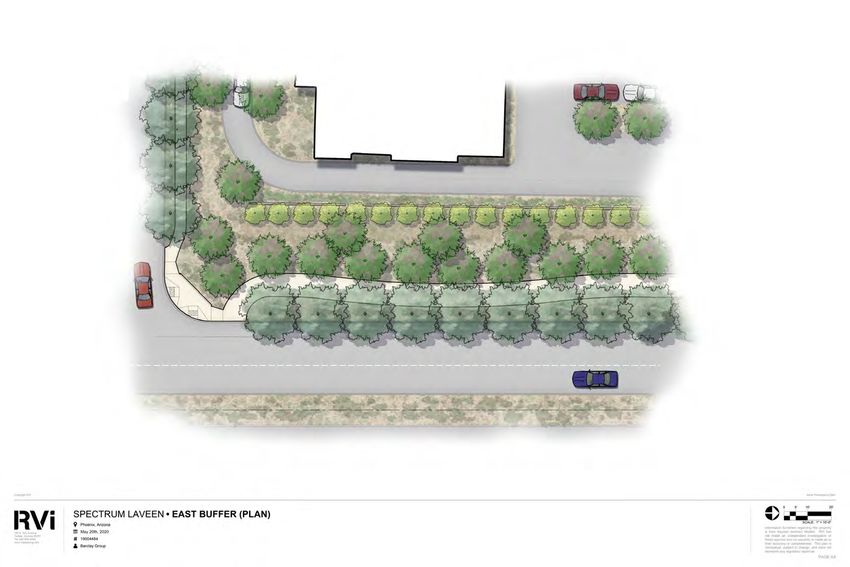
R/W Varies

Figure 5a: Conceptual Streetscape Exhibit - Baseline Road, Section View

                                                          Baseline Road

Figure 5b: Conceptual Streetscape Exhibit - Baseline Road, Plan View
Note:: Figures are provided for conceptual purposes only. Project details, including access point locations, will be solidified during
the Preliminary Site Plan Review process.

LAVEEN SPECTRUM PUD Narrative                                                                                                            23
R/W Varies
Figure 5c: Conceptual Streetscape Exhibit - 59th Avenue, Section View
Project Entry
59th Avenue
Figure 5d: Conceptual Streetscape Exhibit - 59th Avenue, Plan View
Note:: Figures are provided for conceptual purposes only. Project details, including access point locations, will be solidified during
the Preliminary Site Plan Review process.
LAVEEN SPECTRUM PUD Narrative 245c. Landscape Development Standards
The landscape standards for Laveen Spectrum establish minimum standards for the integration of the
built environment into the site’s landscape while providing a comfortable, accessible and aesthetically
pleasing community. The standards listed in Table 3 (Landscape Development Standards), below, define
planting quantities and sizes for streetscapes, perimeter buffers, parking areas and plantings. Standards
not specifically addressed in Table 3 below shall default back to the City of Pheonix zoning ordinance.
TABLE 3: LANDSCAPE DEVELOPMENT STANDARDS
Streetscape Zone - Baseline Road & 59th Avenue
Streetscape Zone landscape standards apply to perimeter landscape setback areas along Baseline Road and
59th Avenue, as specified within Table 2 (Development Standards) and as identified on Figure 4 (Landscape
Zones Plan).
Trees Minimum of one (1) tree per twenty (20) Baseline Road: Min. 2-inch caliper
linear feet, or in equivalent groupings on size (50% of required trees);
both sides of detached pedestrian pathways;
Min. 3-inch caliper size (25% of
Minimum of one (1) tree per twenty (20) required trees);
linear feet, or in equivalent groupings on
one side of attached pedestrian pathways. Min. 4-inch cailper size (25% of
required trees)
59th Avenue: Min. 2-inch caliper
size
Shrubs Minimum of five (5) shrubs per tree Minimum 5-gallon size
Ground Cover Minimum 75% coverage of living plants with Minimum 1-gallon size
2’’ depth decomposed granite topdressing
Shade 75% of public detached sidewalks and trails to shaded at maturity
50% of attached sidewalk along Baseline Road to be shaded at maturity
Pedestrian Amenities One (1) fixed shade structure, twenty (20) linear feet of enhanced surfacing (e.g.
stamped or colored concrete) and one (1) waste receptacle shall be provided at a
minimum interval of one (1) per development sub-area arterial frontage
Bike Infrastructure Bike lanes to be provided along Baseline Road and 59th Avenue in accordance
with City of Phoenix standard cross sections
Bike parking shall be provided per Section 1307.H of the Phoenix Zoning
Ordinance
Landscape strips Minimum Width = 6'
between detached
pedestrian pathways Trees = Minimum of one (1) tree per twenty (20) linear feet, or in equivalent
and curbs groupings, Minimum 2" caliper size min.
Note: landscape strips may be reduced in the event of a utility conflict and/or to
comply with ADA requirements.
LAVEEN SPECTRUM PUD Narrative 25Project Gateways
Project Gateways are required at major site entrances identified on Figure 4 (Landscape Zones Plan). Where
Project Gateway landscape and shade standards conflict with Streetscape Zone standards specified within
this table, Project Gateway standards shall prevail.
Trees Minimum of one (1) tree per twenty (20) Min. 2” caliper size – 25%, Min. 3”
linear feet, or in equivalent groupings on caliper size – 50%, Min. 4” caliper
both sides of detached pedestrian pathways size - 25%
Minimum of one (1) tree per twenty (20)
linear feet, or in equivalent groupings on
one side of attached pedestrian pathways
Shrubs Minimum six (6) shrubs per tree Minimum 5-gallon size
Ground Cover Minimum 75% coverage of living plants with Minimum 1-gallon size
2’’ depth decomposed granite topdressing
Area Minimum 500 square feet of open space at both corners of project gateway entry
roads
Enhanced Elements Utilize tall plant species, such as Date Palms, to highlight enhanced entries and
to promote wayfinding.
Employ enhanced lighting, signage, and art elements to emphasize entry features
Provide hitching posts at Project Gateway along Baseline Road
Shade Min. 75% of detached pedestrian walkways to be shaded at maturity
Min. 50% of the existing attached sidewalk along Baseline Road to be shaded at
maturity.
Landscape strips Minimum Width = 6'
between detached
pedestrian pathways Trees = Minimum of one (1) tree per twenty (20) linear feet, or in equivalent
and curbs groupings, Minimum 2" caliper size min.
Note: landscape strips may be reduced in the event of a utility conflict and/or to
comply with ADA requirements.
LAVEEN SPECTRUM PUD Narrative 26Perimeter Buffer Zone - North & West
Perimeter Buffer Zone standards apply to perimeter landscape setback areas along the freeway frontage and
northern perimeter property line (not adjacent to a public street), as specified within Table 2 (Development
Standards) and as identified on Figure 4 (Landscape Zones Plan).
Trees Minimum of one (1) tree per twenty (20) Min. 1" caliper size – 25%
linear feet, or in equivalent groupings
Min. 2” caliper size – 75%
Shrubs Minimum of five (5) shrubs per tree Minimum 5-gallon size
Ground Cover Minimum 50% coverage of living plants with Minimum 1-gallon size
2’’ depth decomposed granite topdressing
Residential Zone
Residential Zone standards apply to landscape areas and pedestrian walkways associated with residential
development within the portions of Development Sub-Areas 2 and 3 not within the Streetscape Zone and the
Perimeter Buffer Zone.
Landscape Standards for the Residential Zone to be in conformance with Section 507 Tab A and Section
703.
Shade 50% of pedestrian walkways to be shaded at maturity
Commercial Zone
Commercial Zone standards apply applies to landscape areas and pedestrian walkways associated with non-
residential development within the portions of Development Sub-Areas 1 and 2 not within the Streetscape Zone
along 59th Avenue and Baseline Road and the Perimeter Buffer Zone.
Landscape Standards for the Commercial Zone to be in conformance with Section 623.E.4.e.
Shade 50% of pedestrian walkways to be shaded at maturity
Bus Stops
Shade 50% of bus stop pads to be shaded at maturity
LAVEEN SPECTRUM PUD Narrative 275d. Parking Standards Parking areas should be designed to promote an appropriate distribution of parking throughout each development parcel. Where appropriate, buildings should have prominence adjacent to streets with a majority of parking to the side or rear. Where parking is provided adjacent to streets, appropriate screening should be employed using screen walls to a minimum height of 36” inches. 5e. Walls & Fences Walls and fences will provide security, screening, and character for commercial and residential developments within Laveen Spectrum. Residential communities within Development Sub-Areas 1 and 2 may be gated. Walls along Baseline Road and 59th Avenue shall be constructed in accordance with the wall details provided in Appendix K: Perimeter Design Corridor Supplement to the PUD Narrative. All walls and fences shall comply with the Phoenix Zoning Ordinance Section 703 (Landscaping, Fences and Walls), except as noted below: PERIMETER WALLS AND FENCES Perimeter walls refer to walls at the perimeter of the overall PUD and shall include elements of open fencing, other than chain link, to help maintain Laveen’s open character. Walls visible from arterial streets must have breaks to avoid a long blank face. Any blank walls adjacent to arterial streets shall be limited to a maximum length of 40-feet along a continuous plane, at which the wall shall be articulated with a setback, change of materials, use of artwork, or other design features. A maximum of 75% of each development sub-area’s arterial frontage may be screened with a solid wall greater than 36” high. The remaining 25% shall be comprised of open fencing (view fence) elements or no fence. The maximum height allowed by right for perimeter walls along the site’s Congressman Ed Pastor / Loop 202 Freeway frontage constructed as part of a residential use development (includes assisted living center and nursing home uses) is 10-feet. Pursuant to Zoning Ordinance Section 307.A.7, perimeter walls exceeding 10 feet in height along the site’s Congressman Ed Pastor / Loop 202 Freeway frontage constructed as part of a residential use development shall require the approval of a use permit. PARKING AREA SCREEN WALLS Parking areas within all development sub-areas are to be screened from adjacent streets. Screening for parking areas must include screen walls with the option for additional landscape screening. Parking area screen walls shall be beween 36” and 40" in height. LAVEEN SPECTRUM PUD Narrative 28
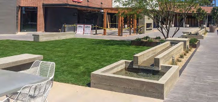
5f. Amenities
Outdoor amenity areas are essential to cultivating health, community
interaction, and an enjoyment of the outdoors. Amenity improvements
will occur in conjunction with construction of each phase of the
development.

Each residential development is to include a minimum of one (1)
primary community amenity and one (1) secondary community
amenity. An additional secondary community amenity is required to be
provided for every 300 additional residential units in excess of the initial
300 units. Primary amenities are intended to spur active recreational
opportunities and community gathering. Primary amenities may
include features such as, but not limited to the following: community
center, fitness facility, pool and/or spa, yard games, sport courts, fire
pits, shaded picnic areas, outdoor kitchens and grills, community
gardens, tot lots and similar active amenity features. Secondary
amenities are intended to facilitate more passive enjoyment of the
outdoor environment. Secondary amenities may include features
such as, but not limited to the following: fire pits, dog park, seating
area, ramadas, picnic tables and community gardens. Minimum of one
(1) primary community amenity and one (1) secondary community
amenity shall be provided with an additional one (1) secondary
amenity provided for each additional 300 residential units in excess of
the initial 300 units.

       • Primary community amenities to have a minimum of one (1)
         ramada or shade structure.

       • Primary community amenities to have a minimum of two (2)
         trash and/or recycling receptacles.

       • Secondary community amenities to have a minimum of one
         (1) trash and/or recycling receptacle.

       • Secondary community amenities to include seating for a
         minimum of four (4) individuals. Minimum 50% of seating
         areas to be shaded.

       • Primary and secondary community amenities to include
         appropriate lighting to facilitate visibility and safety after
         dark.

LAVEEN SPECTRUM PUD Narrative                                                  29
5g. Pedestrian Circulation
Pedestrian circulation and connectivity are essential components of
the Laveen Spectrum PUD. The pedestrian circulation system has been
designed to direct pedestrians to the pedestrian circulation spines
along Baseline Road and 59th Avenue. These corridors will serve as
the primary circulation route connecting the three development sub-
areas and the development parcels within them. As noted in Section
5c (Landscape Zones) above, Baseline Road and 59th Avenue feature
enhanced landscape setbacks, landscaping, streetscape treatments,
and shading all designed to maximize the pedestrian experience.
Additional pedestrian connections between compatible commercial
uses within Development Sub-Areas 1 and 2 are to be evaluated as the
project develops. See Figure 6 (Conceptual Circulation Plan).
GENERAL PEDESTRIAN CIRCULATION
• A system of clearly defined, accessible pathways shall be
provided within each development sub-areas.
• Enhanced surfacing materials, such as stamped or colored
concrete or other pavement treatments, that visually
contrast with the adjacent parking and drive aisle surfaces
shall be provided to delineate all areas where pedestrian
paths cross drive aisles.
• The pathway systems shall provide direct connections
between the following site elements: sidewalks, primary and
secondary amenities, all non-residential building entrances
and exits, where pedestrian paths cross drive aisles, bicycle
facilities, bus stops, and project gateways.
• All pedestrian pathways shall be shaded at a minimum of
50% at maturity.
• Detached sidewalks and trails within the Baseline Road and
59th Avenue Streetscape Zones and Project Gateways are to
be shaded at a minimum of 75% at maturity.
• Pedestrian circulation is to be directed toward the enhanced
pedestrian routes adjacent to the Baseline Road and 59th
Avenue arterials. A minimum of two pedestrian connections
to these arterials are required per development sub-area
arterial frontage as identified on Figure 6: Conceptual
Circulation Plan.
LAVEEN SPECTRUM PUD Narrative 30CONG
Note: Driveway locations and median breaks are to be
established during the site plan review process and shall be
R
C EOSNSGM
in conformance with applicable City details and standards.
RAENS SE D
Development
Sub-Area 3
M A PNA S
Development
Sub-Area 3
ED T OPRA
S/ TLOORO P
/ L2 O
0 2O F
P R2E0E2 W
Development
59TH AVENUE
Sub-Area 2
Pedestrian connections
FA
between commercial
R YE
Development
uses to be evaluated.
59TH AVENUE
Sub-Area 2
EWAY
Legend: Pedestrian connections
between commercial
Streetscape Zone uses to be evaluated.
Residential Zone
Legend:
Commercial
StreetscapeZone
Zone
Project Gateway
Residential ZoneZone
Existing 6' Attached
Commercial Zone Concrete
Sidewalk Project
Project Gateway Zone Gateway
10' Detached Concrete
ExistingUse
Shared 6' Attached
Path Concrete Development
Sidewalk Sub-Area 1 Project
10' Natural Surface Multi-Use
10' Detached Concrete Gateway
Trail
Shared Use Path Development
Proposed Pedestrian Sub-Area 1
10' Natural Surface
Connection Multi-Use
to Development
Trail
Sub-Areas
ProposedPrimary
Proposed Pedestrian
Vehicular BASELINE ROAD
Connection to Development
Access
Sub-Areas
Proposed Secondary
ProposedAccess
Vehicular Primary Vehicular BASELINE ROAD
Access
Proposed Secondary
Vehicular Access SCALE: NTS
LAVEEN SPECTRUM FIGURE 7: PEDESTRIAN CIRCULATION PLAN
Figure 6: Conceptual Circulation Plan
PHOENIX,
Note:: Figures AZ
are provided SCALE:
for conceptual purposes only. Project details, including access point locations, will be solidified NTS
during
the Preliminary Site Plan Review process.
LAVEEN SPECTRUM FIGURE 7: PEDESTRIAN CIRCULATION PLAN
PHOENIX, AZ
LAVEEN SPECTRUM PUD Narrative 31MULTI USE TRAILS
• A 10-foot wide detached, natural surface trail is required
along Baseline Road.
• The sidewalk along 59th Avenue will be widened to a 10-foot
wide detached concrete shared use path.
• Multi-use trails and shared use paths must be designed and
constructed in accordance with City of Phoenix standard
details.
• Provide a minimum of two (2) clear and accessible pedestrian
connections from each development sub-area to and from
the pedestrian spines provided as part of the Streetscape
Zones along Baseline Road and 59th Avenue.
5h. Bicycle Amenities
• Bicycle parking shall be provided per Section 1307.H of the
Phoenix Zoning Ordinance.
• Artistic style racks (in adherence to City of Phoenix
Preferred Designs in Appendix K of the Comprehensive
Bicycle Master Plan) or “Outdoor/Covered Facilities” for
guests and employees shall be encouraged. These facilities
shall be located near building entrances, installed per the
requirements of Section 1307.H of the Zoning Ordinance and
as approved by the Planning and Development Department.
5i. Screening
Screening for any unsightly site elements such as ground mounted
mechanical equipment and parking must be screened by a solid wall,
with the option of additional landscape screening. Plants as primary
screening shall not be permitted. Trash compactors and dumpsters
shall be screened with a masonry wall architecturally compatible with
surrounding structures with a minimum of six (6) feet height, not to
exceed eight (8) feet height.
LAVEEN SPECTRUM PUD Narrative 325j. Lighting
Given the dynamic mix of uses planned for the site, lighting must respond to both daytime and nighttime
needs to create a welcoming environment that prioritizes safety and security as well as aesthetics.
Architectural lighting is an essential component of building and landscape elements. Exterior lighting
throughout the site will meet or exceed the provisions set forth in Section 507.Tab A.II.A.8: Site Lighting of
the Phoenix Zoning Ordinance and Phoenix City Code Section 23-100: Outdoor Lighting. Exterior lighting
shall comply with the following provisions:
• Walkways and open space areas shall be lighted to promote safety and to allow for nighttime use
where appropriate.
• Dramatic lighting should enhance primary architectural features.
• Accent lighting should be incorporated on secondary building elements such as blank walls to
highlight their texture or on columns to reveal their cadence on a façade.
• Special consideration should be given to creating an ambiance with mood lighting, such as
overhead string lights or up lighting/down lighting on walls.
• Lighting shall almost exclusively use warmer temperatures. Cool temperature lighting is
discouraged.
• No luminaries should have any blinking, flashing or fluttering lights or other illuminating device
which has a changing light intensity, brightness or color, nor is any beacon light permitted except
those required for fire alarm and/or emergency systems.
• Lighting on exterior wall in proximity to storefront area is encouraged to help increase tenant
identity and to provide an appropriate level of comfort and rhythm for the pedestrian.
• Lighting should enhance or be an extension of the design intent of the architecture.
• Utilize full cut-off or fully shielded fixtures and set mounting heights as required to effectively
control glare, light trespass, and maintain dark skies.
• Pole mounted light fixtures shall not exceed a height of 18-feet, including lamp, pole and base, as
measured from the adjacent grade Use automatic controls systems to eliminate excessive light
during non-active hours of site and building operation.
LAVEEN SPECTRUM PUD Narrative 336. DESIGN
GUIDELINES
The Laveen Spectrum development plan will promote flexibility in uses
and site design while providing consistent design standards and guidelines
to direct development of the individual parcels within the site. The design
guidelines serve as a critical tool to ensure ongoing compatibility between
uses as the project develops. Phoenix Zoning Ordinance design guidelines
for sustainability, architectural design, site plan design and landscape
design, as specified as requirements, presumptions and considerations
by Section 507 Tab A, apply to all development within Laveen Spectrum.
In addition, all development within the Laveen Spectrum PUD will adhere
to the following PUD Design Expectations.
6a. Design Expectations
SUSTAINABILITY
OBJECTIVE – PROVIDE THERMAL COMFORT FOR ALL USERS
• Minimum 50% shading of all publicly accessible sidewalks and
walkways by means of vegetation at maturity and/or shade
structures.
• Minimum 75% shading of all publicly accessible sidewalks and
trails within the Streetscape Zone along Baseline Road and 59th
Avenue and within Project Gateways by means of vegetation at
maturity and/or shade structures.
• Minimum 50% shading of all open space areas by means of
vegetation at maturity and/or shade structures.
OBJECTIVE – SUSTAINABLE NEIGHBORHOODS THAT PROVIDE
A VARIETY OF HOUSING OPPORTUNITIES WITHIN THE SAME
COMMUNITY
• This PUD allows for residential housing developments of varied
product types, such as apartments, townhomes, detached and
attached single-family residential, auto courts, green courts,
and other residential types.
LAVEEN SPECTRUM PUD Narrative 34ARCHITECTURAL DESIGN
OBJECTIVE – VISUAL INTEREST WITH UNIFIED ELEMENTS TO
ESTABLISH A SENSE OF PLACE
• Manipulation of massing – vertical and horizontal changes
in plane: The proposed building orientations should respect
the orientation of surrounding buildings and streets by
maintaining continuity of pedestrian routes and promoting
opportunities for pedestrian interaction at street-level.
• Building articulation: Building facades facing public streets
that exceed 100 feet in length should contain architectural
embellishments and detailing such as textural changes,
pilasters, offsets, recesses, window fenestration, shadow
boxes and overhead/canopies.
• Incorporating innovative textures, materials, colors:
Building facades facing Baseline Road or 59th Avenue shall
incorporate a minimum of three (3) different materials.
• Building offsets, reveals, recesses, building projections,
masonry piers, or other architectural treatment: Building
offsets, reveals and recesses to be a minimum of three (3)
feet in depth.
• Distinct Entry Features: Entry features are to be clearly
identifiable and shall incorporate functional shade elements
such as awnings and canopies to create a comfortable entry
experience while addressing pedestrian scale.
• Decorative Site Lighting: Section 5l (Lighting) prescribes
lighting standards and guidelines to be deployed throughout
Laveen Spectrum.
LAVEEN SPECTRUM PUD Narrative 35SITE DESIGN / DEVELOPMENT
OBJECTIVE – INNOVATIVE DESIGN OF ACCESS, CIRCULATION,
PRIVACY, SECURITY, SHELTER, AND OTHER FACTORS TO
CREATE A UNIQUE LOCATION THAT COMPLEMENTS THE
SURROUNDING CONTEXT
• Identifiable building streetscape: Section 5c (Landscape
Zones) prescribes Streetscape Zone enhancements for
Laveen Spectrum’s arterial frontages.
• Mitigation of adverse effects (screening, landscape
buffers, wall heights, etc.): Enhanced landscape buffers
will be provided along the site’s arterial frontages. A
minimum 50-foot building setback will be provided along
Baseline Road and a minimum 30-foot building setback will
be provided along 59th Avenue. These setback areas include
enhanced streetscape landscaping, and parking areas will
be screened by minimum 36-inch high solid screen walls.
Additional discussion of screening and walls is provided in
Section 5g (Walls & Fences) and Section 5h (Screening).
OPEN SPACE DESIGN
OBJECTIVE – PROVIDE DIVERSIFIED AMENITIES FOR
OPTIMUM RECREATIONAL USE AND GATHERING PLACES FOR
COMMUNITY INTERACTION
• Improved plazas, courtyards, break areas: A minimum
of one (1) enhanced pedestrian plaza and/or promenade
shall be provided within commercial parcels that exceed
five (5) acres in size. The plaza and/or promenade shall be a
minimum of 500 square feet and shall include shading and
seating elements as well as landscaping elements including
enhanced surfacing materials (e.g. stamped or colored
concrete), specimen plantings, and lighting. A minimum
of 50% of improved plazas, courtyards, and break areas are
to be shaded and a minimum of two seating elements are
required to be provided.
• Shading through structures such as ramadas, canopies,
covered rest areas, and functional landscaping: Minimum
50% shading of all open space areas to be provided.
• Active and passive recreation such as tot lots, ramadas,
splash pads, benches, barbeques, and other appropriate
LAVEEN SPECTRUM PUD Narrative 36You can also read