LOWER GREEN RIVER NATIONAL WILDLIFE REFUGE COMPLEX HABITAT MANAGEMENT PLAN - February 2021
←
→
Page content transcription
If your browser does not render page correctly, please read the page content below
U.S. FISH & WILDLIFE SERVICE

      LOWER GREEN RIVER NATIONAL WILDLIFE
      REFUGE COMPLEX
      HABITAT MANAGEMENT PLAN

                                                   Jaclyn Kircher/USFWS

Johnson Bottom at Ouray National Wildlife Refuge

      February 2021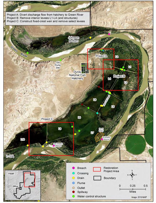
Lower Green River National Wildlife Refuge Complex Habitat Management Plan, February 2021

TABLE OF CONTENTS
Introduction ..................................................................................................................................... 1
Project I. Complete the hydrologic restoration of Sheppard Bottom............................................ 13
       Sub-Activity A: Obtain accurate elevations of post-construction infrastructure funded by
       CRI ........................................................................................................................................ 14
       Sub-Activity B: Extend low water crossing to relic channel ................................................ 14
       Sub-Activity C: Remove S1 cross-levee............................................................................... 15
       Sub-Activity D: Design a new visitor services auto tour route ............................................ 15
Project II: Improve Hydrology of Leota Bottom .......................................................................... 19
       Sub-Activity A: Divert discharge flow from hatchery to the Green River ........................... 20
       Sub-Activity B: Removal interior levees L1 – L4 ................................................................ 21
       Sub-Activity C: Construct fixed-crest weir and remove select levees to reconnect
       hydrologic flow path ............................................................................................................. 21
Project III: Experimental Restoration of a Farm Field to Native Vegetation ............................... 27
       Sub-Activity A: Site selection, seedbed preparation, and planting ...................................... 28
       Sub-Activity B: Post-planting management ......................................................................... 29
Project IV: Restore hydrology of Hoy Bottom, Browns Park NWR ............................................ 31
       Sub-Activity A: Remove levee bisecting bottom ................................................................. 32
       Sub-Activity B: Fill in drainage ditches at the southern end ................................................ 32
       Sub-Activity C: Alter discharge location of inlet canal ........................................................ 32
References ..................................................................................................................................... 34
Appendix A – Background and guidance information ................................................................. 35
       What is the Habitat Management Plan? ................................................................................ 35
       What is the Refuge Purpose? ................................................................................................ 35
Appendix B – Common and scientific names of plant and animals referenced in text ................ 37

Table of Contents                                                                                                                                    i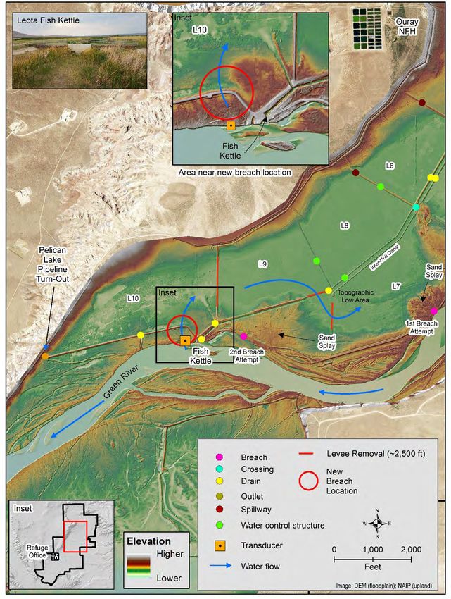
Lower Green River National Wildlife Refuge Complex Habitat Management Plan, February 2021

TABLES
Table 1. Lower Green River National Wildlife Refuge Complex HMP projects support multiple
USFWS priorities. ........................................................................................................................... 2
Table 2. Lower Green River NWR Complex Habitat Management Plan projects and associated
sub-activities, benefits, efficiencies gained, and key metrics. ........................................................ 6
Table 3. Lower Green River NWR Complex Habitat Management Plan projects, sub-activities,
timeline, and operational considerations......................................................................................... 8

FIGURES
Figure 1: Location map showing Browns Park and Ouray National Wildlife Refuges.................. 3
Figure 2: Habitat map for Ouray National Wildlife Refuge. .......................................................... 4
Figure 3: Habitat map for Browns Park National Wildlife Refuge. ............................................... 5
Figure 4: Overview of Sheppard Bottom showing existing infrastructure, new CRI infrastructure
and changes, and modifications to existing auto tour route. ......................................................... 16
Figure 5: Sheppard Bottom CRI infrastructure and extension of relic channel. ........................... 17
Figure 6: Progression of river bank erosion near the auto tour route at Sheppard Bottom. ......... 18
Figure 7: Overview of Leota Bottom illustrating infrastructure (including old pumping site). ... 23
Figure 8: Project 2A, move hatchery waste water to Green River. .............................................. 24
Figure 9: Project 2B, L1-L4 infrastructure removal. .................................................................... 25
Figure 10: Project 2C, evaluate fix-crest weir in new breach location, remove select sections of
levee, and other infrastructure to improve hydrologic function. .................................................. 26
Figure 11: Project 3, restoration of farm field in Sheppard Bottom. ............................................ 30
Figure 12: Project 4, partial hydrologic restoration of Hoy Bottom on Browns Park NWR. ....... 33
Lower Green River National Wildlife Refuge Complex Habitat Management Plan, February 2021

ABBREVIATIONS
CCP             Comprehensive Conservation        HMP           Habitat Management Plan
                Plan
                                                  NWR           National Wildlife Refuge
CRI             Cooperative Recovery Initiative
                                                  USGS          U.S. Geological Survey
ESD             Ecological Site Descriptions
HGM             Hydrogeomorphic Analysis

Abbreviations                                                                                 iii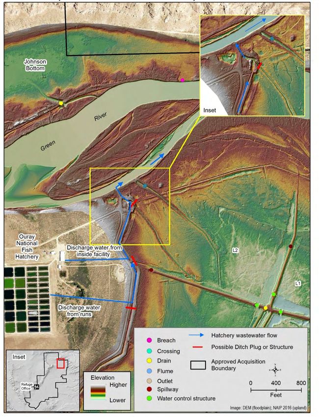
Lower Green River National Wildlife Refuge Complex Habitat Management Plan, February 2021

INTRODUCTION
The Lower Green River National Wildlife Refuge Complex (Complex) is comprised of the
11,987-acre Ouray National Wildlife Refuge (NWR) located in the Uintah Basin and the 13,455-
acre Browns Park NWR located in northwest Colorado (Figure 1). Both Refuges are located
adjacent to the Green River and were established for “use as an inviolate sanctuary, or for any
other management purpose, for migratory birds” (Appendix A). Construction of Flaming Gorge
Dam (completed in 1962) on the Green River above Browns Park has significantly altered river
flows on both Refuges. However, Green River flows at Ouray NWR are supplemented by
unregulated flows from the Yampa River. Primary habitat types on both Refuges include
herbaceous wetlands and riparian forests hydrologically connected to the Green River with
smaller inclusions of semi-desert shrublands, grasslands, and bluffs with sparse vegetation cover
(Figures 2 and 3). A limited area of pinyon-juniper also occurs on Browns Park NWR.

This Habitat Management Plan (HMP) is an operational document identifying priority
restoration and infrastructure improvements on both Refuges. Projects identified for inclusion in
the HMP were determined based on objectives identified in the comprehensive conservation
plans (CCP) for each Refuge (U.S. Fish and Wildlife Service 1999, 2000; Appendix A), as well
as contributions to both the Regional Director and Assistant Regional Director-Refuges priorities
(Table 1; Appendix A). Information used to develop projects included various site-specific
ecological assessments (Heitmeyer et al. 2005; Striffler and Schafer 2015; Fredrickson and
Henry 2016), other published literature, spatial data, and local knowledge of station staff. In
general, these projects identify opportunities to restore ecosystem characteristics that will
improve long-term habitat sustainability for migratory birds, the federally listed razorback
sucker, and other focal species.

This plan describes each project in detail, including contributions to achieving CCP goals and
objectives; ecological benefits and efficiencies gained (Table 2); and spatially explicit
operational considerations (Table 3, Figures 4-11). Implementation of the HMP will occur along
with Annual Habitat Work Plan activities, and both will inform the Complex Inventory &
Monitoring Plan currently in development. Periodic revisions of the HMP may occur with
changing environmental conditions that influence Complex lands or additional knowledge is
gained through implementation and monitoring activities.

Introduction

                                                                                                1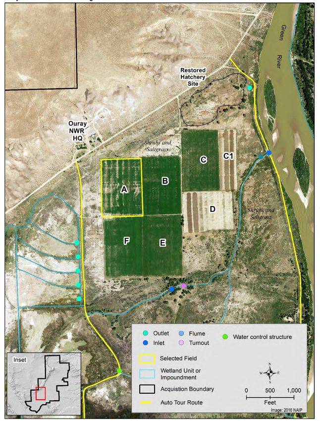
Lower Green River National Wildlife Refuge Complex Habitat Management Plan, February 2021
TABLE 1. LOWER GREEN RIVER NATIONAL WILDLIFE REFUGE COMPLEX HMP PROJECTS SUPPORT
MULTIPLE USFWS PRIORITIES.
Priority:
Priorities: Assistant Lower Green River NWR
Project Regional
Regional Director, Refuges Complex CCP Goals
Director
Recover threatened and Goal A: Restore and enhance
Recover the endangered species when riparian and wetland habitats
razorback refuge lands play a Goal B: Provide habitats that
sucker (one significant role in support the recovery of federally
I. Complete hydrologic
of four recovery listed species
restoration of Sheppard
endangered Landscape protection Goal D: Minimize wildlife
Bottom, Ouray NWR
Colorado and when necessary exposure to environmental
River fish restoration contaminants
species) Ecological sustainability Goal E: Provide opportunities for
and improved efficiency wildlife-dependent recreation
Recover threatened and
Recover the endangered species when
razorback refuge lands play a
Goal A: Restore and enhance
sucker (one significant role in
II. Partial hydrologic riparian and wetland habitats
of four recovery
restoration of Leota Goal B: Provide habitats that
endangered Landscape protection
Bottom, Ouray NWR support the recovery of federally
Colorado and when necessary
listed species
River fish restoration
species) Ecological sustainability
and improved efficiency
III. Restore farm fields
Ecological sustainability Goal C: Maintain healthy grassland
to native vegetation,
and improved efficiency and semidesert shrubland habitats
Ouray NWR
Landscape protection
Wetland Goal: Manage Refuge
IV. Restore hydrology and when necessary
wetlands to meet the migratory
of Hoy Bottom, Browns restoration
and/or breeding requirements of
Park NWR Ecological sustainability
wetland-dependent birds
and improved efficiency
Introduction
2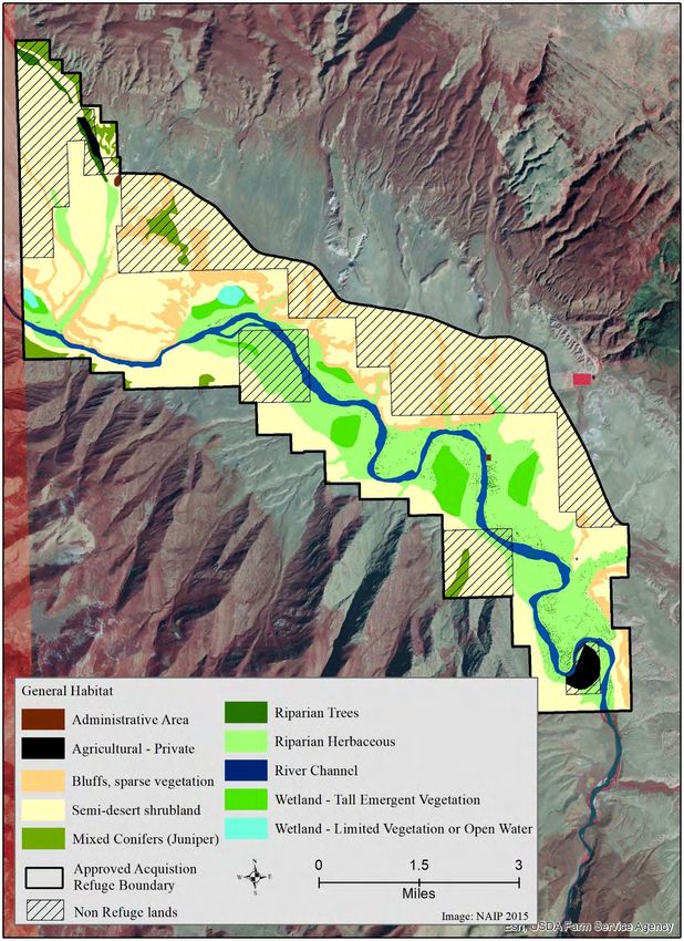
Lower Green River National Wildlife Refuge Complex Habitat Management Plan, February 2021

Figure 1: Location map showing Browns Park and Ouray National Wildlife Refuges.

Introduction

                                                                                              3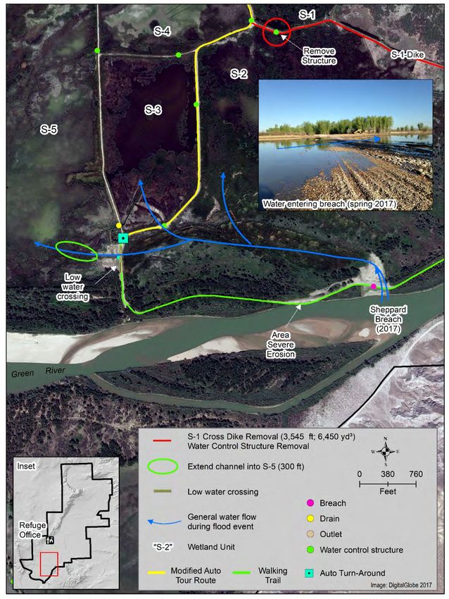
Lower Green River National Wildlife Refuge Complex Habitat Management Plan, February 2021

Figure 2: Habitat map for Ouray National Wildlife Refuge.

Introduction

                                                                                              4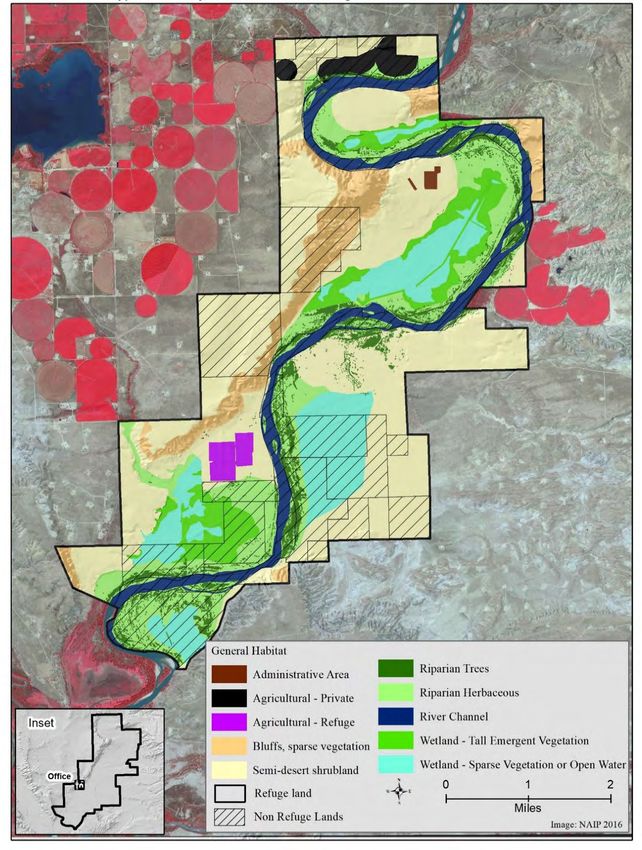
Lower Green River National Wildlife Refuge Complex Habitat Management Plan, February 2021

Figure 3: Habitat map for Browns Park National Wildlife Refuge.

Introduction

                                                                                              5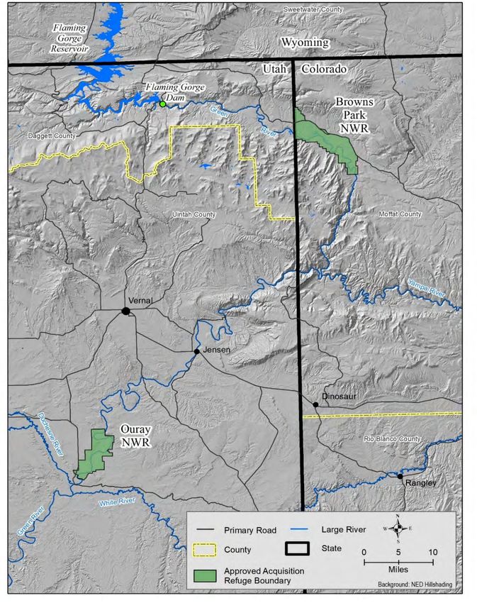
Lower Green River National Wildlife Refuge Complex Habitat Management Plan, February 2021

TABLE 2. LOWER GREEN RIVER NWR COMPLEX HABITAT MANAGEMENT PLAN PROJECTS AND ASSOCIATED SUB-ACTIVITIES, BENEFITS,
EFFICIENCIES GAINED, AND KEY METRICS.
 Projects and Sub-Activities                     Ecological and/or Human
                                                                                      Efficiency Gained                    Key Metrics
 (Sequential Order)                              Safety Benefits
 Project I. Complete hydrologic restoration of
 Sheppard Bottom, Ouray NWR (~300 acres)
  A: Obtain accurate elevations of post-         Identify optimum elevations for                                           Accuracy of post-construction
                                                                                      Reduced operation costs
  construct infrastructure                       water management                                                          elevations
                                                                                                                           Surface water flow
                                                                                      Reduced maintenance and
 B: Extend low water crossing to relic           Complete hydrologic restoration;                                          characteristics; soil selenium
                                                                                      operation costs of inlet structure
 channel                                         improve vegetation composition                                            concentrations; plant
                                                                                      and canal
                                                                                                                           community composition
                                                                                      Reduced time and cost required       Surface water flow
                                                 Complete hydrologic restoration;
 C: Remove S1 Cross-Levee                                                             to manage water and                  characteristics; plant
                                                 improve vegetation composition
                                                                                      undesirable plant species            community composition
  D: Design a new visitor services auto tour     Reduced human disturbance;           Reduced cost of maintaining
                                                                                                                           Public acceptance of new route
  route                                          improved visitor safety              and opening/closing roads
 Project II. Partial hydrologic restoration of
 Leota Bottom, Ouray NWR (~ 600 acres)
                                                 Improved hydrology of upper
                                                                                      Reduced time and cost required       Surface water dynamics; plant
 A: Divert discharge flow from hatchery to       portion of bottom; improved
                                                                                      to manage water and                  community composition and
 the Green River                                 herbaceous and riparian
                                                                                      undesirable plant species            distribution
                                                 vegetation composition
                                                 Improved hydrology of upper                                               Surface water dynamics;
                                                                                      Reduced infrastructure
                                                 portion of bottom; improved                                               cottonwood regeneration; plant
 B: Remove interior levees L1 – L4                                                    maintenance cost; reduced time
                                                 herbaceous and riparian                                                   community composition and
                                                                                      to manage water and vegetation
                                                 vegetation composition                                                    distribution
                                                 Improved hydrologic function;        Reduced maintenance of               Riparian and herbaceous plant
 C: Construct fixed-crest weir and remove
                                                 reduced incidence of undesirable     infrastructure (water-control        community composition;
 select levees to reconnect flow path
                                                 plant species                        structures and roads)                razorback sucker survival
 Project III. Experimental restoration of a
 farm field to native vegetation, Ouray NWR
 (Field A, 26 acres)
                                                                                      Reduced maintenance and              Reduction in farmed area; soil
 A: Site selection, seedbed preparation, and
                                                 Increased native habitat             operation costs of irrigation        properties; plant community
 seeding
                                                                                      system                               composition
                                                                                      Reduced long-term
 B: Post-planting management                     Improved quality of native habitat                                        Plant community composition
                                                                                      maintenance costs

Introduction                                                                                                                                       6
Lower Green River National Wildlife Refuge Complex Habitat Management Plan, February 2021
Projects and Sub-Activities Ecological and/or Human
Efficiency Gained Key Metrics
(Sequential Order) Safety Benefits
Project IV. Restore hydrology of Hoy Bottom,
Browns Park NWR (~ 220 acres)
Restored hydrologic function; Surface water dynamics; plant
Reduced maintenance and
A: Remove levee bisecting bottom improved plant community community composition and
operation costs
composition distribution
Introduction 7Lower Green River National Wildlife Refuge Complex Habitat Management Plan, February 2021
TABLE 3. LOWER GREEN RIVER NWR COMPLEX HABITAT MANAGEMENT PLAN PROJECTS, SUB-ACTIVITIES, TIMELINE, AND OPERATIONAL CONSIDERATIONS.
Refuge Total
Station Staff Station Other1 Partners
Sharing Cost2
Personnel Force MAT Contract
Projects and Sub-Activities (in sequential order) Year Month Cost ($) Item (hours) Cost ($) Type (hours) Cost ($) Name Cost ($)
(hours) Acct Option 1 Option 2
Project I. Complete hydrologic restoration of
Sheppard Bottom, Ouray NWR (~300 acres)
A: Obtain accurate elevations of post-construction
2019
infrastructure funded by CRI
Collect breach elevation data 2018 August WTR (24) $927
Process Survey Data and Produce Map 2019 March WTR (16) $618
Total $1,545 $1,545 $1,545 $1,545
B: Extend low water crossing to relic channel 2021
RO (Arc/ES;
Administration (contracts, grant, oversight) 2021 January PL (8) $616 $736
16 hrs)
Excavate channel (includes mobilization) 2021 January ORY WG (40) $1,400 dozer
Mobilization costs. The cost for this reflects a per
cubic yard (CY) cost only for 1,000 CY. The final
Equipment
excavation cost will be calculated when final plans 2021 January $2,700 $5,120
transport
are developed to ensure grade and slope. The cost
will reflect 1,000 CY removed
Total $2,016 $736 $2,752 $5,452 $7,872
C: Remove S1 cross-levee 2021
Develop Project Maps 2020 June WTR (6) $234
Minimal –
Public outreach/communication 2021 May
Ouray Web
Administration (contracts, grants, oversight, Permits, RO (Arc/ES; USCOE
2021 May PL/SM (20/hrs) $1,430 $920 $736
404) 20 hrs) (16 hrs)
Tribal Consultation 2021 May PL (8 hrs) $616
Excavator with
ORY WG (40
Remove Water Control Structure 2021 Sept. $1,400 thumb and jack
hrs)
hammer
MAT or
Levee removal (3,540 feet; 8,076 CY) This is just to ORY WG (160
Contract
excavate on site with limited stockpiling of soil. This hrs/10 days) for
Hours
cost to contract is assumed to be with either an (A) the 200HP $5,600 –
2021 Sept. Dozer should $21,800 $41,344
80 HP Dozer or a (B) 200 HP dozer. Most USFWS dozer and 320 $11,200
remain the
Dozers are 80HP although we own a few 200HP Hrs 20 days for
same. Time
located throughout the region. The cost for the 80HP dozer
depends on
Introduction 8Lower Green River National Wildlife Refuge Complex Habitat Management Plan, February 2021
Refuge Total
Station Staff Station Other1 Partners
Sharing Cost2
Personnel Force MAT Contract
Projects and Sub-Activities (in sequential order) Year Month Cost ($) Item (hours) Cost ($) Type (hours) Cost ($) Name Cost ($)
(hours) Acct Option 1 Option 2
contract/MAT per CY is (A) $5.12/$2.70 and (B) (note double the equipment
$4.30/$2.25 per CY time) on hand.
Total $14,646 $1,154 $736 $15,800 $37,600 $57,144
D: Design a new visitor services auto tour route 2020
FHA Cost in
Design Route (parking locations, signs, etc.) 2019 Sept. PL/SM (16 hrs) $1,144
(16 hrs) contract
FHA Cost in
Administration (NEPA, outreach) 2019 Sept. PL (16 hrs) $1,232
(40 hrs) contract
FHA
Improve roads and construct parking areas 2020 Sept. Road Base $10,000 $600,000
Contract
Sub-
Gate, Signs 2020 Sept. PL/SM (8 hrs) $572 FHA
element
Total $2,948 $10,000 $600,000 $12,948 $12,948 $12,948
Project I. Grand Total $600,736 $33,045 $57,545 $79,509
Project II. Partial hydrologic restoration of Leota
Bottom, Ouray NWR (~600 acres)
A: Divert discharge flow from hatchery to the
2022
Green River
Jones/Fry
Consultation with Hatchery Station Manager 2020 July PL/SM (40 hrs) $2,860 $736
(16 hrs)
Fry (40
Administration (oversight, contracts, grants, permits, hrs)
2021 April PL (40 hrs) $3,080 RO (Arc/ES) $552 $2,944
NEPA) USACE
(24 hrs)
Survey and develop project maps 2021 July WTR (24x2) $552
More detailed topo survey WTR (24) $888
ORY WG
Install ditch plug 2021 Oct. $1,400
(40 hrs)
Construct and grade ditch to river (Cost Calculated
ORY WG Trackhoe with
for 1,000 CY. Final cost will be calculated when a 2021 Nov. $2,800 $3,197 $6,986
(80 hrs) angle blade
detailed plan exists with proper grade elevations.
Monitor flow 2021 Nov. From hatchery $2,500
If monitoring
Install water control structure 2022 August $65,000
indicates
Total $77,640 $1,992 $3,680 $79,632 $82,829 $86,618
Introduction 9Lower Green River National Wildlife Refuge Complex Habitat Management Plan, February 2021
Refuge Total
Station Staff Station Other1 Partners
Sharing Cost2
Personnel Force MAT Contract
Projects and Sub-Activities (in sequential order) Year Month Cost ($) Item (hours) Cost ($) Type (hours) Cost ($) Name Cost ($)
(hours) Acct Option 1 Option 2
B: Remove interior levees L1 – L4 2023
RO staff
Administration (permits, contracts, oversight) 2022 April PL (80 hrs) $6,160 $552 USACE
(Arc,ES)
PL Ouray Web
Public outreach/communication 2022 August $1,232
site (16 hrs)
Remove levees (~10,500 feet; 84,933 CY) This cost
to contract is assumed to be with either an (A) 80 HP
Dozer or a (B) 200 HP dozer. Most USFWS Dozers 2022- Sept.- MAT (10
BOR $229,319 $434,856
are 80HP although we own a few 200HPs located 23 Dec. wks)
throughout the region. The cost for contract/MAT per
CY is (A) $5.12/$2.70 and (B) $4.30/$2.25 per CY
Remove water-control structures (n = 6) this includes
Mob and Demob along with debris removal and off ORY WG (160
2022 Sept. $5,600 excavator $9,440 $26,150
site hauling with dump trucks p to 26 miles round hrs)
trip.
Total $12,992 $552 $13,544 $252,303 $474,550
C: Construct fixed-crest weir and remove select
2023
levees to reconnect flow path
Arc/FAC/ES
FAC/Recovery Program consultation 2023 April PL/SM (40 hrs) $2,860 $1,840
(40 hrs)
PL (8 hrs)
Public outreach/communication 2023 May $616
Ouray web site
Collect river stage data at proposed breach site 2019 May SM (40 hrs) $2,640 WTR (10) $390
Administration (contracts, grants, oversight, permits FAC/ES (40
2023 June PL (40 hrs) $3,080 $1,560
[NEPA, 404, state lands, Section 7]) hrs)
Breach design 2023 July WTR (20) $780 ES (8) $312
$260,000
Breach construction 2023 August BOR (contract $260,000
only)
L10, L9, L7 levee removal (~10,000 feet; 38,000
CY) This cost to contract is assumed to be with
either an (A) 80 HP Dozer or a (B) 200 HP dozer.
MAT (5
Most USFWS Dozers are 80HP although we own a 2023 August BOR $104,500 $194,560
wks)
few 200HPs located throughout the region. The cost
for contract/MAT per CY is (A) $5.12/$2.70 and (B)
$4.30/$2.25 per CY
Introduction 10Lower Green River National Wildlife Refuge Complex Habitat Management Plan, February 2021
Refuge Total
Station Staff Station Other1 Partners
Sharing Cost2
Personnel Force MAT Contract
Projects and Sub-Activities (in sequential order) Year Month Cost ($) Item (hours) Cost ($) Type (hours) Cost ($) Name Cost ($)
(hours) Acct Option 1 Option 2
Total $9,196 $1,170 $3,712 $14,078 $378,578 $468,638
Project II. Grand Total $3,680 $107,254 $713,710 $1,029,806
Project III. Experimental restoration of a farm
field to native vegetation, Ouray NWR (Field A,
26 ac.)
A: Site selection, seedbed preparation, and
2023
seeding
PL/SM/COOP
Farmer consultation 2019 Feb. $1,716
(24 hrs)
Public outreach/communication 2023 March PL/SM (8 hrs) $572
USGS/private
Collect and evaluate soil samples 2021 June RE (160 hrs) $6,240 $1,560
(40)
Seedbed prep (triticale) 2020 April COOP $0
Shrubs/grass
Seed shrubs and grass species 2023 March RE (40 hrs) $1,560 $5,000
seed
Post planting (irrigation) 2023 April COOP $0
Total $10,088 $6,560 $16,648 $16,648 $16,648
B: Post-planting management 2025
Monitor native shrubs establishment and expansion 2024 April RE (160 hrs) $6,240
March- Herbicide
Control invasive and ruderal species as necessary 2024 RE (160 hrs) $6,240
August applications
Collect soil samples in established areas to determine RE (160) if
2024 June NRCS (40 hrs) $1,560
soil structure and chemistry changes necessary
Interseed native grasses if necessary 2024 April COOP (40 hrs) $1,560 Seed
Change water right share locations if irrigation is no As
2025 PL (24 hrs) $1,716 WTR (24 hrs) $1,716
longer needed needed
Total $15,756 $3,276 $19,032 $19,032 $19,032
Project III. Grand Total $35,680 $35,680 $35,680
Project IV. Restore topography of Hoy Bottom,
Browns Park NWR (~220 acres)
A: Remove levee bisecting bottom 2024
Administration (contracts, grants, permits) 2024 PL/SM (40 hrs) $2,860
Public outreach/communication 2024 SM (8 hrs) $528
Flow path analysis and project map development 2019 WTR (20) $780
Introduction 11Lower Green River National Wildlife Refuge Complex Habitat Management Plan, February 2021
Refuge Total
Station Staff Station Other1 Partners
Sharing Cost2
Personnel Force MAT Contract
Projects and Sub-Activities (in sequential order) Year Month Cost ($) Item (hours) Cost ($) Type (hours) Cost ($) Name Cost ($)
(hours) Acct Option 1 Option 2
Remove 7,000 feet of levee (~32,000 CY)
and use material to fill ditches and restore natural
topography This cost to contract is assumed to be
with either an (A) 80 HP Dozer or a (B) 200 HP
2024 BRP WG MAT $86,400 $163,840
dozer. Most USFWS Dozers are 80HP although we
own a few 200HPs located throughout the region.
The cost for contract/MAT per CY is (A)
$5.12/$2.70 and (B) $4.30/$2.25 per CY
Total $3,388 $780 $4,168 $90,568 $168,008
B: Fill and shape discharge ditches to natural
topography (2,300 feet) This will be calculated on a
per week utilization of a grader and a dozer for 1 2024 MAT $6,820 $13,590
week. Industry standard is to reshape from 3:1 slope
to grade at 500 feet per day for dozer and roller
Total $6,820 $13,590
C: Alter discharge location of inlet canal and fill
950 feet of the canal that is no longer needed.
2024 BRP WG MAT $3,725 $9,475
Unknown quantity at this time. However, equipment
operations for 5 days will be calculated.
Total $3,725 $9,475
Project IV. Grand Total $4,168 $101,113 $191,073
1 Category includes equipment; material; and contract costs. Equipment costs are based on in-house equipment use (running costs) and standard maintenance costs.
2 The “MAT Option 1” and “Contract Option 2” costs consist of the sum of the “Force Acct” costs and the estimated costs to complete the project via either a MAT team, or via a contract – the two
Total Costs are not additive and are presented to show the different costs depending on how the project work is completed.
Abbreviations specific to Table 3 are as follows:
BOR – Bureau of Reclamation NEPA – National Environmental Policy Act Sept. – September
BRP – Browns Park National Wildlife Refuge Nov. – November SM – Station Manager
COOP – Cooperative Farmer NRCS – Natural Resources Conservation Service USACE – U.S. Army Corps of Engineers
CY – cubic yard Oct. – October USFWS – U.S. Fish and Wildlife Service
Dec. – December ORY – Ouray National Wildlife Refuge USGS – U.S. Geological Survey
ES – Ecological Services PL – Project Leader WG – Wage Grade
FAC – Fisheries and Aquatic Conservation RE – Rangeland Ecologist WTR – Water Resources Division
MAT – Maintenance Action Team RO – Regional Office
Introduction 12Lower Green River National Wildlife Refuge Complex Habitat Management Plan, February 2021
PROJECT I. COMPLETE THE HYDROLOGIC RESTORATION OF
SHEPPARD BOTTOM
Associated CCP Goals and Objectives
Goal A: Restore and enhance riparian and wetland habitats for migratory birds that depend upon
the Green River corridor.
Objective 1: Improve structure and composition of woody and herbaceous riparian
communities to provide nesting, feeding, loafing and resting habitat for migratory birds.
Objective 2: Improve structure and composition of submergent and emergent wetland
communities to provide nesting, feeding, loafing, and resting habitat for migratory birds.
Goal B: Provide habitats that support the recovery of federally listed and Utah special status
species on or adjacent to the Refuge.
Objective 1: Provide habitats that support the recovery of Colorado River endangered
fishes (razorback sucker, Colorado pikeminnow, humpback chub, bonytail).
Goal D: Minimize wildlife exposure to environmental contaminants on or adjacent to the
Refuge.
Objective 1: Reduce the selenium concentration on 240 acres within Sheppard Bottom
S3/S5.
Goal E: Provide opportunities for wildlife dependent recreation.
Objective 1: Provide opportunities for wildlife photography, wildlife observation,
hunting, and fishing.
Contribution to the CCP
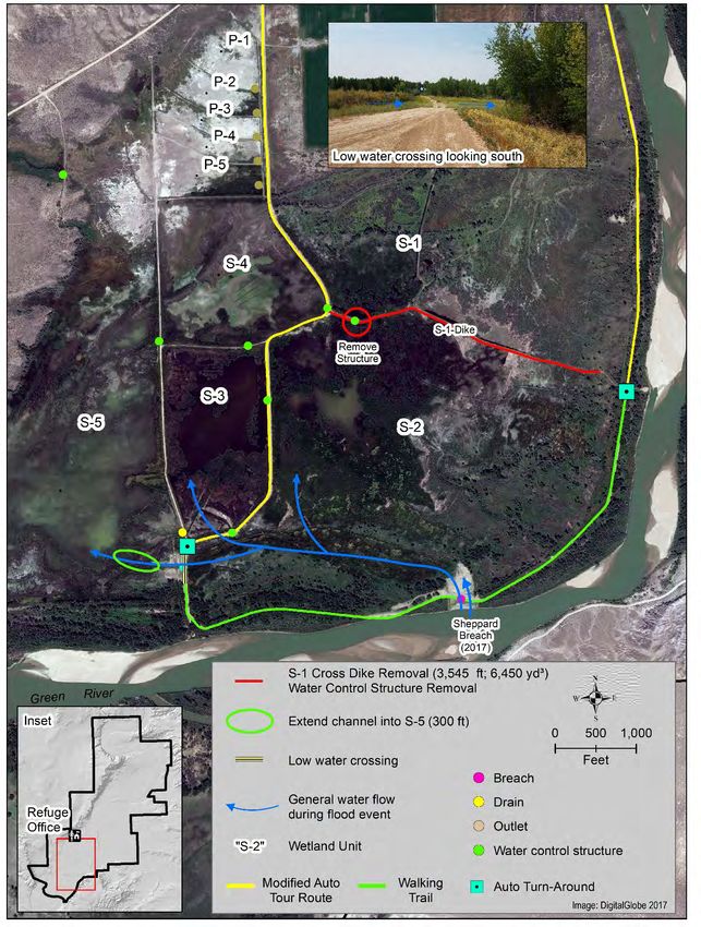
Sheppard Bottom is a 967-acre floodplain wetland that is hydrologically connected (surface and
subsurface) to the Green River. The topography and hydrology (frequency, magnitude, depth,
and duration) of the wetland was significantly altered soon after Refuge establishment by the
construction of levees/roads to create five impoundments (S1-S5), installation of numerous
water-control structures, and development of a water conveyance infrastructure (i.e., discharge
canals, capacity to pump water from Pelican Lake) to facilitate management (Figure 3). The
hydrology of the wetland was further compromised by the construction of Flaming Gorge Dam
on the Green River upstream of the Refuge that altered river flows (frequency, magnitude,
duration) that determined the historic flood pattern of Sheppard Bottom (Heitmeyer et al. 2005).
The results of these modifications include elevated concentrations of selenium and the loss and
degradation of riparian and wetland plant communities (e.g., extensive distribution of cattail,
encroachment of saltcedar and Russian olive, reduced cottonwood regeneration; see Appendix B
for scientific names). Ultimately, these changes have reduced the diversity of resources (foods,
Project I 13Lower Green River National Wildlife Refuge Complex Habitat Management Plan, February 2021 vegetation structure) necessary to support focal wildlife species, including a diversity of waterbirds and the federally listed razorback sucker (U.S. Fish and Wildlife Service 2000). The Ouray NWR CCP (U.S. Fish and Wildlife Service 2000) identified the need to restore floodplain wetlands and a Hydrogeomorphic Analysis (HGM; Heitmeyer et al. 2005) was conducted to compile and interpret the information necessary to evaluate options. The HGM formed the basis of a proposal funded by Cooperative Recovery Initiative (CRI) in 2016 to restore Sheppard Bottom. Project activities included constructing a fixed-crest weir on the Green River, a low water crossing in an existing levee (that also functions as part of the existing auto loop) that interrupts flow in the relic channel, excavation of soil material in the relic channel to facilitate flow, and installation of a structure in S3 to facilitate entrainment of larval razorback suckers. Unfortunately, wet conditions and limited funding prevented removal of soil material in the relic channel below the low water crossing to completely reconnect the relic channel to the Green River downstream. The incomplete construction currently causes the low water crossing to retain water for longer periods than designed. This HMP project will complete the hydrologic restoration of Sheppard Bottom. Post- construction elevations of the fixed-crest weir, water-control structures, and the low water crossing will be determined and used to guide to finish removal of soil material in the relic channel and ensure backflooding into Sheppard Bottom at the appropriate location. In addition, the auto tour road will be ended just prior to the low water crossing. (Figure 4). The new auto route will use existing roads up to the turnarounds and will not affect the removal of the S1 cross-levee, which currently bisects a portion of the bottom and alters surface hydrology. SUB-ACTIVITY A: OBTAIN ACCURATE ELEVATIONS OF POST-CONSTRUCTION INFRASTRUCTURE FUNDED BY CRI Summary – Lidar data, in combination with site-specific survey data, was used to develop design plans for the fixed-crest weir and low water crossing. However, the current benchmark elevations are not consistent with the Lidar data and some elevation adjustments were required during construction. As a result, accurate elevations of the newly constructed infrastructure is not known and this information will be required to complete the connection of the relic channel to the river and confirm the proper elevation of the S3 water-control structure. Management Efficiencies – Accurate data will facilitate creating the proper grade of the relic channel, which will minimize infrastructure maintenance costs and enable monitoring the hydrology of the wetland to assess success relative to CCP and fish recovery objectives. SUB-ACTIVITY B: EXTEND LOW WATER CROSSING TO RELIC CHANNEL Summary – Due to wet conditions during original project construction, removal of soil material to achieve the proper grade of the relic channel downstream of the low water crossing was not completed (Figure 5). Completing this flow-path connection by removing soil material that has aggraded the channel is required to facilitate backflooding at the proper location, minimize sediment deposition in the wetland, enhance the movement of selenium to the river, and prevent structural damage of the low water crossing. Project I 14
Lower Green River National Wildlife Refuge Complex Habitat Management Plan, February 2021

Management Efficiencies – Restoring the proper flooding and dewatering locations will
minimize annual and long-term maintenance costs associated with infrastructure repairs,
vegetation control, sediment removal, and potentially selenium mitigation.

SUB-ACTIVITY C: REMOVE S1 CROSS-LEVEE
Summary – The S1 cross-levee, and associated water-control structure and ditches adjacent to
the levee, has altered the hydrology of Sheppard Bottom at higher elevations (Figure 4). Surface
water remains in ditches for extended periods and the structure does not allow for complete
removal of surface water in a timely manner, which creates conditions that promote the
establishment of cattail adjacent to ditches and eventual encroachment into the basin. The levee
will be removed and the material used to fill the ditches and restore the natural topography of the
bottom.

Management Efficiencies – Removal of infrastructure will reduce maintenance costs (levee and
water-control structure) and potentially reduce the frequency and intensity of treatments
necessary to control robust emergent vegetation.

SUB-ACTIVITY D: DESIGN A NEW VISITOR SERVICES AUTO TOUR ROUTE
Summary – The existing auto tour route has been a safety concern for several years due to
erosion of the levee at several locations adjacent to the Green River (Figure 6). In addition,
construction of the fixed-crest weir and low water crossing to restore hydrology crossed the tour
route and created additional safety concerns during times of high water. Repairing the levee and
improving the infrastructure to support safe passage for visitor vehicles would require significant
funds, potentially could compromise the ecological benefits of the new infrastructure, and likely
jeopardize the long-term viability of the route. Therefore, a new auto tour route was designed in
consultation with staff of the Region 6 Facilities Branch and Division of Scientific Resources
that uses existing roads and avoids compromising wetland function (Figure 4). However, some
modifications will be required including road surface rehabilitation in some locations,
construction of turn-around locations and parking lots, and placement of signs. In addition,
portions of the existing auto tour route will be converted to a walking trail to continue public
access.

Management Efficiencies – The new route will provide visitors with a safe, reliable viewing
experience of Refuge habitats that does not cause ecological harm. It is anticipated that
maintenance costs of this new route will be lower than the current route because it will not
require staff to control access (e.g., close the road during high water) and major repairs will be
required with less frequency.

Project I                                                                                            15
Lower Green River National Wildlife Refuge Complex Habitat Management Plan, February 2021

Figure 4: Overview of Sheppard Bottom showing existing infrastructure, new CRI infrastructure and
changes, and modifications to existing auto tour route.

Project I                                                                                           16
Lower Green River National Wildlife Refuge Complex Habitat Management Plan, February 2021

Figure 5: Sheppard Bottom CRI infrastructure and extension of relic channel.

Project I                                                                                       17
Lower Green River National Wildlife Refuge Complex Habitat Management Plan, February 2021

Figure 6: Progression of river bank erosion near the auto tour route at Sheppard Bottom.

Project I                                                                                       18
Lower Green River National Wildlife Refuge Complex Habitat Management Plan, February 2021

PROJECT II: IMPROVE HYDROLOGY OF LEOTA BOTTOM
Associated CCP Goals and Objectives

Goal A: Restore and enhance riparian and wetland habitats for migratory birds that depend upon
the Green River corridor.

        Objective 1: Improve structure and composition of woody and herbaceous riparian
        communities to provide nesting, feeding, loafing and resting habitat for migratory birds.

        Objective 2: Improve structure and composition of submergent and emergent wetland
        communities to provide nesting, feeding, loafing, and resting habitat for migratory birds.

Goal B: Provide habitats that support the recovery of federally listed and Utah special status
species on or adjacent to the Refuge.

        Objective 1: Provide habitats that support the recovery of Colorado River endangered
        fishes (razorback sucker, Colorado pikeminnow, humpback chub, bonytail).

Contribution to the CCP

Similar to Sheppard Bottom, extensive infrastructure development of Leota Bottom also
occurred soon after Refuge establishment. Levees with water-control structures were constructed
to create ten impoundments with material for levee construction obtained on-site resulting in the
creation of ditches (“borrow pits”) within impoundments (Figure 7). In addition, a pump station
was installed in the river, and a central ditch constructed to distribute water to each
impoundment. However, improper location of the pump upstream of the bottom created
problems with maintaining the pump site and increased sediment discharge to the wetland. The
pump site was abandoned in favor of a gravity driven water delivery mechanism that still results
in sediment issues. Finally, operation of the Ouray National Fish Hatchery results in a relatively
constant flow of hatchery waste water to the upper portion of the bottom (Units L1 – L4) that
collects in ditches adjacent to interior levees. Collectively, these alterations have altered basin
topography and compromised the hydrology (frequency, duration, magnitude, depth) of the
wetland, resulting in extensive stands of dense cattail monocultures that has reduced the diversity
and abundance of waterbird use.

Past attempts to restore Leota Bottom have included the removal of the pump station,
construction of a breach in the protective levee (Unit L7) adjacent to the river to facilitate
flooding, and modifying internal levees with spillways to improve movement of water during
high flow events. However, the initial breach was not in the proper location or at the proper
elevation and became inoperable shortly after construction. To remedy this issue, a second
breach of the protective levee (Unit L7a) was constructed, but it also was improperly sited and
does not function properly. In addition, the inter-unit spillway elevations are too high to facilitate
timely movement of water within the impoundment system. As a result, significant hydrostatic
pressure occurs on the levees during large magnitude flood events and Refuge staff must spend
considerable time managing water using water-control structures to protect the infrastructure.
Regardless of these efforts, damage to the infrastructure is common following high flow events.

Project II                                                                                         19
Lower Green River National Wildlife Refuge Complex Habitat Management Plan, February 2021 In summary, the infrastructure continues to compromise the ability to provide quality wetland habitat. Dense stands of cattail still dominate most impoundments and invasive weeds, especially saltcedar and Canada thistle, are prevalent on wetland edges. As a result, waterbird diversity and use remains low. For example, during the spring of 2013, peak numbers of dabbling ducks was 440 in L3 and L4 (47 acres flooded) and 1,289 in L6 (42 acres flooded) (Refuge files, 2013). This project represents the initial actions necessary to restore the hydrology of higher elevations within the bottom (L1 – L4) by diverting the constant discharge of hatchery waste water to the Green River and restoring natural topography (e.g., levee removal, ditch fill) to the extent possible. In addition, reports prepared specifically for Ouray NWR (Heitmeyer and Fredrickson 2005; FLO Engineering 1997, 1999) will be used in combination with on-site information to identify an appropriate location for construction of a fixed-crest weir and restore topography (levee removal, ditch fill) of the lower bottom (L7 – L10). This action will restore the hydrologic connection of the bottom to the river at a location that can be maintained long-term and minimize sediment discharge into the basin. Collectively, accomplishing these actions will improve site conditions for establishment of native riparian and herbaceous vegetation necessary to support species in need of conservation, improve hydrologic conditions that will improve the ability to recover razorback sucker, and simultaneously reduce maintenance and operational costs. The restoration actions will be monitored to determine appropriate actions that will be required to complete the restoration of the middle portions of the bottom in the next HMP. SUB-ACTIVITY A: DIVERT DISCHARGE FLOW FROM HATCHERY TO THE GREEN RIVER Summary – Currently, all discharge water from the hatchery raceways and propagation tanks flows into L2 and L4, respectively. The volumetric flowrate is variable depending on hatchery operations and cleaning periods and is typically 800 to 1000 ac-ft per year. An earthen conveyance ditch was constructed to divert water to other impoundments, but it is difficult to maintain and water tends to flow into ditches adjacent to cross-levees. Because the cross-levees are not cored, water also seeps under the levees and fills ditches on the other side. The flow is sufficient to create permanently flooded conditions in the ditches, which promotes the establishment and expansion of robust emergent vegetation (e.g., cattail) in the impoundments. Water-control structures (i.e., concrete box culverts) currently exist at the intersection of the hatchery discharge ditches and the ditch constructed at the edge of the bottom. Based on LiDAR data, an opportunity exists to use existing structures and canals to divert the hatchery discharge water directly to the Green River. Refuge staff will determine the need for permits and consult with the Hatchery Manager to confirm diverting flow to the river is acceptable prior to implementation. Installation of a ditch plug (or modification of the existing structure) will be required to direct flow in the correct direction (Figure 8). In addition, a topographic survey will be conducted to identify additional ditch construction required to export water to the river and guide removal of fill in the existing ditch to achieve the appropriate grade necessary to transport water to the river. Management Efficiencies – Restoring more natural hydrology to the L1 – L4 impoundments will help reduce the incidence of cattail establishment and encroachment, as well as the creation of soil conditions conducive for establishment of invasive plants, particularly saltcedar and Canada thistle. Currently, significant resources (time, funds) are expended to treat these undesirable Project II 20
Lower Green River National Wildlife Refuge Complex Habitat Management Plan, February 2021

species. In addition, accomplishing this task will facilitate access to restore the natural
topography of the area via the removal of levees and filling the adjacent ditches (e.g., Sub-
activity B).

SUB-ACTIVITY B: REMOVAL INTERIOR LEVEES L1 – L4
Summary – The construction of levees and associated ditches that comprise L1 – L4 have
significantly altered the bathymetry of the basin and created areas of permanent and
semipermanent flooding that promote cattail establishment and expansion. Areas adjacent to
these depressions exhibit elevated soil moistures that promote germination of Canada thistle and
saltcedar. Natural topography will be restored by removing levees and using the material to fill
existing ditches (Figure 9). In combination with diverting hatchery flows to the river, this will
allow the upper elevations of the bottom to dry more frequently as was typical pre-development.
Flooding of the area will still occur, but only during medium to high river flow events and only
for limited duration, which should create favorable environmental conditions (e.g., soil moisture)
necessary for establishment of desirable herbaceous vegetation in the lower elevations of the
basin and woody riparian vegetation at higher elevations. Prior to infrastructure removal, Refuge
staff will obtain any necessary permits and public outreach will be conducted to explain the
benefits of infrastructure removal.

Management Efficiencies – Removal of infrastructure will reduce maintenance and operational
costs, although some maintenance of remaining infrastructure will be required following flood
events of high magnitude or duration. In addition, the change in hydrology should reduce the
costs associated with treatment of cattail and invasive species.

SUB-ACTIVITY C: CONSTRUCT FIXED-CREST WEIR AND REMOVE SELECT LEVEES
TO RECONNECT HYDROLOGIC FLOW PATH

Summary – Historically, water overtopped the natural levee and entered the bottom at numerous
locations during high river flow events. In contrast, water entered the bottom on the downstream
side where the elevation of natural levees was lowest during moderate flow events.
Unfortunately, the construction of Flaming Gorge Dam has significantly reduced the frequency,
magnitude, and duration of flood events and these changes must be taken into account when
restoring the hydrology of floodplain wetlands on the Refuge. Of critical importance is the
proper location and elevation of a fixed-crest weir. In general, the location of water entry to the
bottom must be on the downstream side since backflooding prevents sediment discharge into the
basin, whereas the weir elevation must be evaluated relative to the range of current and
anticipated future river stages to ensure a proper flooding frequency (e.g., 4-7 years out of 10).

Refuge staff in consultation with DSR staff have identified the location for a fixed-crest weir
based on LiDAR, historical imagery, and information previously compiled for the Refuge
(Heitmeyer and Fredrickson 2005; FLO Engineering 1997, 1999). The proposed site is on the
downstream side of Leota Bottom and is adjacent to the existing fish kettle (Figure 10). Although
the fish kettle currently is inoperable, it can be repaired and used to support razorback sucker
recovery. Design of the weir (e.g., elevation, width) will require additional data collection to
develop a site-specific stage-discharge relationship to ensure the target flood frequency is
achieved. Prior to construction of the weir, the natural topography will be partially restored by

Project II                                                                                       21
Lower Green River National Wildlife Refuge Complex Habitat Management Plan, February 2021

removing levees (or levee segments) and filling ditches in L7, L9, and L10 to allow water
passing the weir to emulate the historic flood pattern and occupy the lowest elevations of the
bottom. Following completion of weir design and prior to construction, Refuge staff will consult
with the Colorado River Endangered Fish Recovery office to verify the design, obtain any
necessary permits, and conduct public outreach to educate the public about the project.

Management Efficiencies – A fixed-crest weir in the proper location would minimize
management and maintenance costs associated with infrastructure (e.g., sediment removal, water
damage), whereas restoring the natural topography will reduce the frequency of treatment to
control robust emergent vegetation.

Project II                                                                                      22
Lower Green River National Wildlife Refuge Complex Habitat Management Plan, February 2021

Figure 7: Overview of Leota Bottom illustrating infrastructure (including old pumping site).

Project II                                                                                      23
Lower Green River National Wildlife Refuge Complex Habitat Management Plan, February 2021

Figure 8: Project 2A, move hatchery waste water to Green River.

Project II                                                                                      24
Lower Green River National Wildlife Refuge Complex Habitat Management Plan, February 2021

Figure 9: Project 2B, L1-L4 infrastructure removal.

Project II                                                                                      25
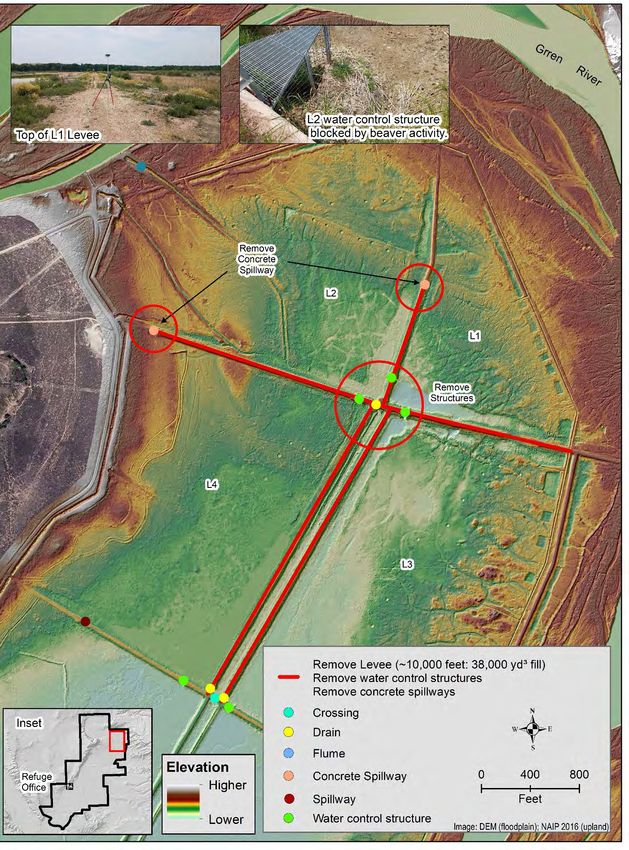
Lower Green River National Wildlife Refuge Complex Habitat Management Plan, February 2021

Figure 10: Project 2C, evaluate fix-crest weir in new breach location, remove select sections of levee,
and other infrastructure to improve hydrologic function.

Project II                                                                                                26
Lower Green River National Wildlife Refuge Complex Habitat Management Plan, February 2021

PROJECT III: EXPERIMENTAL RESTORATION OF A FARM
FIELD TO NATIVE VEGETATION
Associated CCP Goals and Objectives

Goal C: Maintain healthy grassland and semidesert shrubland habitats for wildlife.

        Objective: Investigate whether management techniques exist that can insure the health of
        cold desert grasslands.

Contribution to the CCP

Seven adjacent agriculture fields currently comprise 150 acres (< 1%) of Refuge lands (Figure
11). A local farmer, operating under a cooperative agreement, is responsible for all aspects of
farming. Typically, one field is planted to barley annually for wildlife use and the remaining
fields are planted to alfalfa for harvest by the farmer. The field planted to barley is rotated as
needed for alfalfa production (4 - 5 year rotation). Crops augment available forage for migratory
birds (sandhill crane, Canada goose, mallard), mule deer, elk, and other resident wildlife.
Located adjacent to the tour route, these fields also provide opportunities for wildlife viewing.
However, soil disturbance associated with farming creates suitable conditions for establishment
of invasive plant species (e.g., Russian knapweed) on field edges, which requires considerable
Refuge staff time and funds to control.

The Ouray NWR CCP states the farm fields will be maintained until suitable restoration
techniques are developed, at which time a slow transition toward native plant communities will
occur. Since completion of the CCP, Refuge staff have unsuccessfully attempted to restore native
grassland and shrubland habitat in areas of previous soil disturbance (e.g., abandoned fish
hatchery site, infrastructure construction or repair sites) using various techniques. In 2011,
Refuge staff contracted with Conservation Seeding and Restoration, Inc. to conduct research that
would identify restoration techniques suitable for disturbed sites on the Refuge. The study
evaluated seven native grass species, eight site preparation and seeding techniques (including
irrigation), eight soil amendments, and two seeding dates on two sites (abandoned hatchery, area
adjacent to farm fields) (Manier and Anderson 2017). Each species was seeded in separate rows
and sites were monitored to evaluate establishment rate. The latest monitoring was conducted in
2016 (5 years post-treatment) by personnel from the U.S. Geological Survey, Fort Collins
Science Center (USGS; Manier and Anderson 2017). The analysis of this data indicate treatment
effects varies by species, but mean percent cover of individual species was < 7%. In addition, the
mean percent cover of all species (range: 4 - 54%) was greater in treatment rows not planted with
the designated species, suggesting recruitment occurred from surrounding undisturbed areas,
seeds moved after planting, or both. Regardless, these results suggest the native grasses
evaluated can tolerate existing soil conditions and recovery is possible, although it may require
substantial years to achieve success.

USGS also conducted an independent evaluation of soil properties near the farm fields. Results
indicated soils in this area are alkaline with soluble salt concentrations that typically impede the
growth of all but the most salt-tolerant plant species. In addition, soil dispersion tests indicate

Project III                                                                                        27
Lower Green River National Wildlife Refuge Complex Habitat Management Plan, February 2021 high surface salt concentrations have caused disruption of soil structure on some sites that can reduce plant germination and root development, reduce plant available water, and reduce some plant nutrients (Manier and Anderson 2017). The only samples that did not exhibit dispersion occurred on sites dominated by tall, dense kochia, suggesting that some plant species (e.g., inland saltgrass, kochia) may play a role in ameliorating soil salinity and may contribute to establishment of less salt-tolerant native grasses. During the next five years, Refuge staff will attempt to restore one farm field to native vegetation as defined by Ecological Site Descriptions (ESD) developed by the Natural Resources Conservation Service (https://esis.sc.egov.usda.gov). The farm fields are located in the Alkali Flat ESD and reference plant communities include perennial shrubland, perennial grassland, and perennial grassland/shrubland. Floristic composition varies among types, but maximum shrub cover ranges from 10% in perennial grassland/shrubland to 30% in perennial shrubland, maximum grass cover ranges 10% (perennial shrubland) to 40% (perennial grassland and perennial grassland/shrubland), and maximum bare ground cover ranges from 25% (perennial shrubland and perennial grassland) to 30% perennial grassland/shrubland. In contrast, all reference plant communities support similar coverage of forbs (1 - 10%) and biological crust (10 - 55%). Based on the research on plant establishment and soil properties conducted from 2011 to 2016, achieving a plant community composition within these ranges is more realistic than original attempts to restore a community dominated (> 75%) by native grasses. Wildlife that will benefit from this habitat include Brewer’s sparrow, short-eared owl, loggerhead shrike, among other species. This approach is considered exploratory because it is more passive than previous attempts and initially focuses on establishing native shrubs via seeding and natural recolonization from nearby areas to improve soil conditions prior to seeding native grasses. Progress likely will be slow and require several years; however, exploring this option will lead to additional knowledge regarding a more reliable, less intensive restoration method. SUB-ACTIVITY A: SITE SELECTION, SEEDBED PREPARATION, AND PLANTING Summary – A new cooperative farming agreement recently was signed and the farmer has planted new alfalfa in some fields. Therefore, the Refuge staff will consult with the cooperative farmer to select one field from agricultural production that minimizes impacts to the farmer. There are areas adjacent to the farm fields that currently support black greasewood and inland saltgrass; selection of an adjacent farm field (preferably on two sides) to these areas would be ideal to facilitate natural recolonization of shrubs (Figure 11). In addition, Refuge staff will conduct public outreach to explain the purpose and value of restoration to native vegetation prior to implementation. The selected field will be tilled to remove crop residue and soil samples will be collected to determine existing soil structure (e.g., dispersion, particle size) and chemistry (e.g., electrical conductivity, pH, sodium adsorption ratio). To aid recolonization of shrubs, black greasewood and rabbitbrush seed previously collected by the Refuge Biologist will be broadcast (rates to be determined). Establishment of native shrubs is the first priority to aid in soil stabilization and improve soil structure (e.g., creation of soil macropores and prevention of complete crust formation). It is anticipated that kochia also will become established based on the history of the Project III 28
Lower Green River National Wildlife Refuge Complex Habitat Management Plan, February 2021

site. Initially, this plant will be tolerated (rather than eliminated as in the past) because the root
system will contribute to improving soil structure and prevent wind erosion.

Management Efficiencies – Removal of an agricultural field complies with the Region 6 policy
of reducing agricultural crops on Refuges and reduces costs associated with maintenance of the
wheel-line irrigation system. In addition, the restoration approach will allow collection of
additional soil structure and chemistry data necessary to evaluate further restoration options at a
low cost.

SUB-ACTIVITY B: POST-PLANTING MANAGEMENT
Summary – Native shrub establishment and expansion will be monitored annually by visually
inspecting the site and creating a distribution map. Kochia will be mowed if percent cover
exceeds 80 % to facilitate increased sunlight penetration and soil moisture necessary for native
species to become established. Other invasive species, particularly Russian knapweed, will be
controlled by spot-spraying herbicide as necessary. Soil samples will be collected and analyzed
for changes in soil structure and chemistry when native shrubs occupy an area greater than 400
square feet, which may require several years. Native grasses characteristic of the Alkali Flat ESD
will be interseeded using a broadcast seeder when data indicate soil salinity has decreased below
the threshold required for germination, unless natural recolonization occurs.

Management Efficiencies – This approach is exploratory and will not require substantial staff
time or station funds. However, if successful, it will provide an approach to restore remaining
agricultural fields at minimal cost. At a minimum, obtaining more information on soil structure
and chemistry and the ability of plant species to remediate unfavorable soil conditions will prove
valuable for designing more intensive restoration methods.

Project III                                                                                              29
You can also read