MEADOWBANK MINE FINAL - 2019 WILDLIFE M ONITORING
←
→
Page content transcription
If your browser does not render page correctly, please read the page content below
M E AD O W B AN K G OL D M I N E P R OJ E C T

                 2019 WILDLIFE MONITORING SUMM ARY

MEADOWBANK MINE
 20 1 9 W I L D L I F E M O N I T O R I N G
       S U M M AR Y R E P O R T

                 FIN AL
M E AD O W B AN K G OL D M I N E P R OJ E C T

                                  2019 WILDLIFE MONITORING SUMM ARY

                                                           APPENDIX L

                                                        2019 Whale Tail Raptor Report

April 2020 – FINAL
2019 Wildlife Monitoring Report    Appendices
Prepared For:
Robin Allard
General Supervisor Environment
robin.allard@agnicoeagle.com
Agnico Eagle Mines Limited
Meadowbank Division
Suite 540
Baker Lake, Nunavut
X0C 0A0

Prepared By:
Arctic Raptors Inc.
170 52260 RR223
Sherwood Park, Alberta
T8C 1J3

Contact:
Alastair Franke PhD
alastair.franke@ualberta.ca
780‐292‐2072
Background
Abundance and distribution of raptor nesting sites in the region surrounding the Whale Tail Project was
unknown prior to 2015. The purpose of the raptor monitoring program from 2015 – 2017 focused on
searching for nesting sites located near to, and far from proposed or existing infrastructure. Monitoring
of raptors is outlined in the Agnico Eagle Meadowbank Division Terrestrial Ecosystem Management Plan
(TEMP; Agnico Eagle Mine 2019). The TEMP outlines requirements for avoiding and managing
disturbance to nesting raptors, as follows:
Develop a nest‐specific response plan for identified raptor nests within areas of concern to
ensure that nesting success is not affected by development activities
Follow GN‐DoE guidelines for avoiding disturbance to raptor nests
Discourage raptors from establishing nests on artificial structures, pit walls, or other facilities
Active raptor nest monitoring
In addition, the TEMP also outlines the general monitoring approach, as follows:
document and map raptor nesting sites (see Term or Condition 33)
evaluate the success of mitigation to prevent disturbance to raptors or raptor nests,
estimate project‐related disturbance effects.
develop nesting site‐specific management plans for nests within 1.5km of project infrastructure,
including minimum “no disturbance” buffers (see Commitment 32). In the event of deterrence
of removal of a nest, AEM must contact the GN, and secure the required permits (see Term and
Condition 36).
The GN provided additional raptor‐specific feedback from information provided in 2018 Annual Report,
as follows:
the current monitoring does not have the power to detect and mitigate Project‐related effects
on raptor nesting success.
the study design does support analysis that would allow detection of project‐related nest
failures (e.g., by examining nest success as a function of intensity of project‐related disturbance.
Species Descriptions
Peregrine Falcon (Falco peregrinus tundrius)
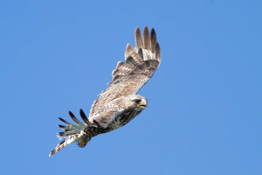
The Arctic peregrine falcon (Figure 1) is medium‐ to large‐sized falcon. It has a dark hood and face with
distinct dark malar stripe, cream to white throat, slate‐grey back; barred belly, legs, and tail. Long
pointed wings, stocky body. Plumage of immature birds brown rather than grey, and the breast is
streaked rather than barred. In adults, the cere and orbital ring are yellow, and bluish in immature birds.
Compared with gyrfalcons, the peregrine is smaller and less stocky. In flight, the wings of peregrines
appear narrower and more pointed. In peregrine falcons, wing tips extend to bottom of the tail when
perched, while in gyrfalcons, wing tips extend two‐thirds down the length of tail
F. p. tundrius breeds mainly north of the treeline from Alaska east throughout northern Canada to
Greenland. It breeds throughout the taiga and tundra wherever suitable nesting habitat and sufficient
prey are present. In Nunavut, peregrines appear to have their highest densities in the Kivalliq and
Kitikmeot regions. Highest breeding density on record is on the western shores of Hudson Bay in the
Kivalliq Region.

F. p. tundrius is a long‐distance migrant, wintering mainly throughout South and Central America, but
also in southern United States and Mexico. Northern‐breeding American and Arctic peregrines are highly
migratory (Yates et al. 1988, Schmutz et al. 1991, Fuller et al. 1998), and although fall migration occurs
over a broad geographic range (Fuller et al. 1998), Yates et al. (1988) indicated that “separate and
distinct autumn migratory populations pass through the east and Gulf coasts” of the United States.

Peregrine falcons usually nests on cliffs and rocky outcrops, but also nest on hilltops, river canyons, rock
screes, and on occasion directly on the ground (Court et al. 1988, Ratcliffe 1993). They prefer nesting in
locations close to water in south‐facing, rugged terrain. Hunting habitat includes rugged coastline areas
and rolling tundra that consists of raised beaches, dry tundra, sedge meadows, wetlands, and lakes that
are inhabited by a diversity of breeding songbirds and shorebirds.

Peregrine Falcons do not build a nest but make a depression (called a scrape) in the substrate on a cliff
ledge. Scrapes are usually approximately 20 cm in diameter and 4 cm deep. Females usually do the
majority of incubation, and brooding of small young. Males provision incubating females and provide
most of the prey when nestlings are small. Thereafter, females do most of the feeding, beginning to
hunt after young are large enough to thermoregulate on their own. Clutch size is typically 3 or 4 eggs in
Nunavut. In Rankin Inlet and Igloolik, the median incubation period of the first egg was 36 days, and
decreased 1 day for each additional egg. The incubation period of the 4th egg (33 days) was similar to
what has been reported elsewhere (Burnham 1983).

The Arctic peregrine falcon is a generalist predator with a diverse diet that includes passerines,
shorebirds , ducks , gulls, terns, jaegers, black guillemots, and, when available, collared lemmings, brown
lemmings, and Arctic ground squirrels. Bradley and Oliphant (1991) indicated that, around Rankin Inlet,
small birds (64% of prey items) represented the greatest portion of prey items, followed by microtine
rodents (25%), large birds (8%), and Arctic ground squirrels (4%). The most important prey measured by
percent biomass were large birds (43%), followed by small birds (25%), microtine rodents (18%), and
Arctic ground squirrels (15%).

In Nunavut, the earliest documented arrival for Peregrine Falcons is 10 May at a known breeding site
near Rankin Inlet. Although arrival timing varies with spring conditions, the majority of sites are
occupied during the 3rd week of May. Median laying date in Rankin Inlet (9 June) is typically earlier than
Igloolik (15 June) and northern Baffin Island (16 June). Median date of hatching ranges from 14 July at
Rankin Inlet to 18 July on northern Baffin Island and 20 July at Igloolik (Jaffre et al. 2015). Birds depart
the breeding grounds from mid‐September through early October, arriving on the wintering grounds
throughout Central and South America in November.

Gyrfalcon (Falco rusticolus)
The gyrfalcon (Figure 2) is large with pointed wings, but more rounded and broader than the wings of
other falcon species. The tail is relatively long. When perched, wings extend 2/3 down the tail. The body
is thick and powerful, particularly in females. Adults have yellow ceres, eye‐rings and legs. As in all
falcons, the eyes appear black. Three main color morphs occur: black, grey and white. White adults
have almost pure white breasts and bellies, with dark wingtips (dipped‐in‐ink appearance). Grey adults
have slate‐colored back, with white underparts mottled with gray arrowhead‐shaped markings. Dark
adults are dark‐grey overall above and dark‐streaked breasts and belly. There is extreme reverse sex
dimorphism, with males being approximately 2/3 the size of females (Ferguson‐Lees et al. 2001).

Gyrfalcons distribution extends throughout the circumpolar Arctic. Most of the breeding range occurs
north of 60°N, but breeding pairs are known to exist as far south as 55°N, mainly along sea coasts in
eastern Canada. Many adults remain within the breeding range throughout the year, but some disperse
southwards in winter, small numbers reaching the norther. United States (Cade 1982, Poole 1987).
Immature birds are much more likely to winter to south of breeding range, and females are thought to
disperse more widely, with many males remaining relatively close to breeding territories throughout the
year.

Ptarmigan are often cited as the most important prey species by biomass, but Arctic ground squirrel and
Arctic hare are also important, as well as small mammals (mice and voles) and other birds (ducks,
sparrows, buntings). In central Nunavut, Poole and Boag (1988) identified eleven species of birds and
five species of mammals among the prey. Birds accounted for three quarters of the diet, and adult rock
ptarmigan were the most common. Arctic ground squirrel and arctic hare, made up the bulk of
mammalian prey.

Males occupy and defend nesting territories as early as the end of January, with females arriving in mid‐
March. In Nunavut, laying typically begin in the first week of May with most pairs laying by the end of
the second week in May. Nestlings typically hatch in mid‐June but hatching can occur throughout June.
Nestlings fledge in late July or early August after 7 weeks in the nest. In Nunavut, gyrfalcon usually nest
on cliff ledges, ideally beneath sheltering overhang; sometimes nests in trees or on man‐made
structures. Nests are generally on rock ledges or abandoned rough‐legged hawk or common raven nests.
Use of alternate nest sites is not uncommon. Pairs do not necessarily attempt breeding every year,
depending on food supply. Typical clutch size is 3‐4 eggs (Booms et al. 2008) that are incubated for 34‐
36 days mostly by the female (ca. 80%). The North American population including Nunavut is considered
to be stable (Clum and Cade 1994, Kirk and Hyslop 1998). Although low spring temperatures are
associated with later arrival at nesting territories in Nunavut (Poole and Bromley 1988), there was no
effect on laying dates. However, (Poole and Bromley 1988) indicated that increased spring precipitation
(snow) reduced reproductive success.

Rough‐legged Hawk (Buteo lagopus)
The rough‐legged hawk (Figure 3) is a medium‐large bird of prey, with a fairly small beak, predominantly
brown in colour and often mottled. Plumage is highly variable with recognized light and dark morphs.
Extensive field experience is required to distinguish between males and females, and between adults
and juveniles based on plumage alone. A broad chest band is evident in most plumage variations, and in
flight, a dark carpal patch is characteristic in light morph individuals. One or more dark terminal bands
appear on the tail. The wing tips are long enough to reach or extend past the tail when the animal is
perched. Legs are feathered to feet (Ferguson‐Lees et al. 2005).

Widespread throughout North America, breeding from the Aleutian Islands, the interior of Alaska,
Yukon, northern Mackenzie, and across Nunavut to northern Labrador and Newfoundland and south to
Manitoba and southeastern Quebec. In Nunavut, rough‐legged hawks are present over most of the
territory except for islands without lemmings (Bechard and Swem 2002).
Regularly hovers, or “kites” while facing into the wind scanning for prey. Soars with wings raised in a
slight dihedral (V‐shape). It is a diurnal raptor that still‐hunts from prominent perching structure on both
breeding and wintering grounds. Prey is captured on the ground. Courtship involves soaring and calling,
with the male engaged in a flight display of repeated undulating stoops rising upward to mid‐air stall. It
is gregarious on migration, often travelling in large flocks, but small groups or individuals are not
uncommon.

During the summer, breeding pairs prefer rugged terrain areas with steeper slopes in areas associated
with primary production (i.e., vegetation), and were most likely to nest in large, productive valleys
surrounded by high‐elevation plateaus (Galipeau et al. 2016). It is widely distributed in winter, usually
found in open habitat resembling the tundra such as prairies, plains, coastal marshes, agricultural fields,
and airports (Johnsgard and Johnsgard 1990). More common in wintering areas typified by short
growing seasons and low precipitation, with highest densities in the northern United States, Great Basin
area, and the western shortgrass prairies (Bock and Lepthien 1976, Bock et al. 1977).

The rough‐legged hawk is a small mammal specialist; thus, its breeding activity is generally associated
with local abundance of ground squirrels, voles, or lemmings (Hanski 1991, Potapov 1997). It will prey
on birds when small mammals are scarce, particularly juvenile passerines and shorebirds, and will resort
to consuming carrion opportunistically (Watson 1986). Usually reproductively mature at 2 years of age.
Stick‐nests are built soon after arrival on territory, typically on cliffs, on bluffs, or on the ground. Clutch
sizes are variable (1‐7 eggs), depending on food availability, but 3‐5 eggs are usual and laid in May.
Incubation 31‐33 days, provided almost entirely by the female. Nestling period is 35‐40 days, and
fledglings remain dependent on adults for another 2 weeks. The male provisions the young and the
female, which feeds the young. Pairs show nest site fidelity, and in locations where ground squirrels are
entirely absent, they may forgo breeding or have small broods when lemmings are low, in contrast to
Snowy Owls, which are truly nomadic (Bechard and Swem 2002). Bechard and Swem (2002) indicated
that egg‐laying date was associated with spring temperatures and snow‐free ledges, but Potapov (1997)
reported no effect of snow melting date or spring/summer temperatures on number of nesting pairs.

Methods

Terminology
The terminology used throughout this report follows (Franke et al. 2017). The following terms are
highlighted in an effort to clarify terminology used in this report, and/or to distinguish terms used from
similar terms that have distinct meaning:

nest — The structure made or the place used by birds for laying their eggs and sheltering their young
(Steenhof and Newton 2007) regardless of whether eggs are laid in the nest in a given year or in any
year (Millsap et al. 2015, Steenhof et al. 2017), see Scrape for Gyrfalcons.

nesting site — The substrate which supports the nest or the specific location of the nest on the
landscape (Ritchie and Curatolo 1982, Millsap et al. 2015, Steenhof et al. 2017).

alternative nesting site — One of potentially several nests within a nesting territory that is not a used
nest in the current year (Millsap et al. 2015).

nesting territory — An area that contains, or historically contained, one or more nests within the home
range of a mated pair: a confined locality where nests are found, usually in successive years, and where
no more than one pair is known to have bred at one time (Newton and Marquiss 1984, Steenhoff and
Newton 2007). Note that a nesting territory may or may not be defended (Postupalsky 1974), and
probably does not include all of a pair’s foraging habitat (Newton and Marquiss 1984, Steenhoff and
Newton 2007).

occupancy — The quotient of the count of occupied nesting territories and the count of known nesting
territories that were fully surveyed in a given breeding season (Franke et al. 2017).

brood size — The actual number of young hatched from a single nesting attempt by a pair of birds. For
studies in which mortality that occurs between hatching and the first observation of the brood is
unknown, it is appropriate to report brood size (i.e., number hatched) only for broods equal to, or less
than 10 days of age. For broods older than 10 days of age, see Brood Size ≥10 days. Report mean and
standard error, or standard deviation.

brood size ≥ 10 days — The number of young hatched from a single nesting attempt by a pair of birds.
For studies in which mortality that occurs between hatching and the first observation of the brood is
unknown, and nestlings are equal to, or greater than 10 days of age, but less than Minimum Acceptable
Age for Assessing Success. Report mean and standard error, or standard deviation.

minimum acceptable age for assessing success — A standard nestling age at which a nest can be
considered successful. An age when young are well grown but not old enough to fly and after which
mortality is minimal until actual fledging. Typically 80% of the age that young of a species normally leave
the nest of their own volition for many species, but lower (65–75%) for species in which age at fledging
varies considerably or for species that are more likely to leave the nest prematurely when checked
(Steenhof and Newton 2007).

nest survival — The probability that a nesting attempt survives over the complete nesting period. When
Daily Survival Rate (DSR; Dinsmore et al. 2002) is assumed to be constant over time and E is the nesting
period (usually expressed in days), nest survival is DSR^E; otherwise nest survival is the product of each
estimated DSR. For raptors, nest survival is the equivalent of nesting success for egg‐laying pairs
(Steenhof et al. 2017).

productivity — The number of young that reach the minimum acceptable age for assessing success;
usually reported as the number of young produced per territorial pair or per occupied territory in a
particular year (Steenhoff and Newton 2007, Steenhof et al. 2017).

total production — The total number of young detected.

Field Surveys
Structured surveys were conducted from 2015 – 2017, and in 2019. The focus of these surveys was to
search known nesting sites for the presence of cliff‐nesting raptors. In addition to the structured
surveys, favourable habitat was searched opportunistically when ferrying between known sites, camps
or other mine infrastructure and when raptors or signs of site use (e.g., whitewash, orange‐colored
lichen, and unused nests) were observed. Sites were considered occupied if one or more adults
displayed territorial or reproductive behavior (e.g., vocalization and/or flight behavior associated with
defense of breeding territory or presence of nest building, nest, or eggs). Locations with partially built or
unused nests without detection of breeding aged adults were noted as such (e.g., old stick nest; no birds
detected). Raptor monitoring in 2019 involved one helicopter survey (13 – 17 June), and ground ‐
monitoring of potential nesting habitat (natural cliffs, quarries and borrow pits) along the Haul Road. A
second survey to evaluate reproductive success, and provide an estimate of detection error was planned
for 7 – 10 August, but was cancelled due to weather, and limitations associated with helicopter
availability and travel logistics.
Data Exploration
Nearest Neighbour Distances
Nearest neighbour distances (NND) were calculated in R (R Development Core Team 2017) using the sp,
rgeos, and geosphere packages to transform nesting site locations into spatial objects, calculate pairwise
distances, and identify the shortest distance between known neighbouring nesting site locations.
Distance to disturbance
Spatial objects (lines and polygons) describing the project footprint were acquired from Agnico Eagle.
Euclidean distances from nesting sites to the nearest spatial object were calculated in R (R Development
Core Team 2017) using the sp, rgeos, and geosphere packages. Summary data were generated using the
hist, boxplot and summary functions in R.
Assigning Nesting Sites to Nesting Territories
In the absence of marked individuals, it can be challenging to definitively identify alternative nesting
sites. Failure to account for alternative nesting sites can lead to underestimating demographic
parameters such as annual productivity. To address this problem, a rule‐based approach was used to
estimate the number of alternative nesting sites within the study area (Figure 4):
If two species‐specific nesting sites were separated by a distance of ≤ 1 km they were
considered alternative nesting sites in a single nesting territory.
If two nesting sites within 1 km of each other were occupied by the same species in a given year,
they were considered separate territories.
If multiple species‐specific nesting sites were within 1 km of one another, discrete geographic
landforms or discontinuities in cliff structure were used to separate or combine sites into
territories.
Temporal patterns of multi‐species occupancy were used to assess the plausibility of decisions based on
the application of the three rules listed above. For example, if two nesting sites were located within 1
km of each other and were occupied by two different species in alternating years, these nesting sites
were identified as distinct alternative nesting sites for each species.
Assigning Identification Numbers (ID) to Nesting Territories was conducted according to the following
rule set:
Nesting Territory IDs were assigned within species only (e.g., Nesting Territory IDs for PEFA and
RLHA were never shared).
Nesting Territory IDs were assigned using the Identification Number of one of the Nesting Sites
in the cluster according to the following rule set, in order of priority:
i. Length of tenure (i.e., nesting sites with the longest tenure)
ii. First tenure (i.e., nesting sites with the first tenure in the event length of tenure was
equal).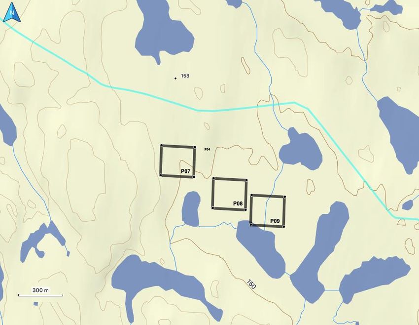
Occupancy
Although it is not possible to estimate detection error without multiple surveys (i.e., fully surveyed),
point estimates without corresponding estimates of error can be calculated as the quotient of the count
of occupied nesting territories and the count of known nesting territories that were surveyed in a given
breeding season, even if they were not fully surveyed. For each species separately, we first tallied the
total count of known nesting sites across all surveys combined. We then adjusted the year‐specific count
of known nesting sites to account for nesting sites that were not known in that year (i.e., had not been
found). Using the methods to assign nesting sites to nesting territories described in the previous
section, we tallied the number year‐specific nesting territories. We then calculated the year‐specific
proportion of known nesting territories that were occupied as a proportion of the known nesting
territories that were surveyed. For visualization purposes only (i.e., no statistical assessment of trend
was attempted), we then used Loess Regression to smoothen the available time series

Results

Data Exploration
Across five different surveys (see Table 1), one‐hundred and fourteen locations considered to be typical
of raptor nesting habitat were surveyed at least once from 2015 – 2017, and 2019 (n.b., no surveys were
conducted in 2018). Of the 114 locations surveyed (Figure 5), nesting raptors have been detected at 58
nesting sites (Table 2). Peregrine falcons have been documented at 43 nesting sites, rough‐legged hawks
at 23 nesting sites and gyrfalcons have been documented at six nesting sites. The mean nearest
neighbour distance (i.e., occupied sites only) was 1.15 km (range = 0.11– 5.36 km). Mean distance from
known occupied nesting sites to the haul road was 13.05 km (range = 0.06 – 29.02 km); one nesting site
fall within 1.5 km of the Haul Road, and is considered a candidate for development of a site‐specific
management plan (see Management Plans). A second survey location falls with the “no disturbance”
buffer, but nesting raptors have not been detected at this location to date. Mean distance from known
occupied sites to the Whale Tail footprint was 17.46 km (range 0.66 – 51.66 km). Two nesting sites fall
within 1.5 km of the Whale Tail footprint, and are considered candidates for development of a site‐
specific management plan (see Management Plans). However, neither are with the 600m limit
identified in Government of British Columbia (2013).

After applying the rule‐based approach to assign nesting sites to nesting territories, we assessed one
peregrine falcon nesting site to be an alternate site within one nesting territory resulting in total of 41
peregrine falcon nesting territories. For rough‐legged hawks and gyrfalcons, two nesting sites for each
species were considered to alternates, resulting in 21 nesting territories for rough‐legged hawks and
four for gyrfalcons.

Point estimates for occupancy indicate that peregrine falcons (mean = 0.63) and gyrfalcons (0.63) have
been stable (Table 1, Figure 6). For rough‐legged hawks, mean occupancy was equal to 0.46, however,
data indicate that a peak occurred in 2017 (0.76), which is a well‐known for small‐mammal specialists
which respond to microtine rodent cycles (Gilg et al. 2006).

Discussion

This report retroactively applies GN‐DoE guidelines (Government of British Columbia 2013) to assess
potential disturbance to known nesting sites that have been identified over the course of five survey‐
years (i.e., active baseline monitoring). Agnico Eagle has developed nest‐specific response plans for
raptor nesting sites within areas of concern to evaluate potential effect of development activities on
breeding success. To date, Agnico Eagle has not detected instances of raptors establishing nests on
artificial structures, pit walls, or other facilities along the Haul Road or Whale Tail site. Furthermore,
mitigation of disturbance has not been necessary as Agnico Eagle has not detected any raptor nests
within 1.5km of existing infrastructure.

To date, monitoring has focused on searching for, documenting and mapping nesting sites for three
raptor species (peregrine falcons, rough‐legged hawks, and gyrfalcons). Study design has been limited
to single surveys conducted annually since 2015 (except for 2018), which does not allow for estimation
of detection error in estimates of occupancy (i.e., project‐related disturbance effects). To address this
limitation, starting in 2020, the study design shall be updated to incorporate multiple surveys annually,
and will take advantage of the distribution of known nesting sites to monitor occupancy and
reproductive success as a function of distance to project‐related disturbance, and other covariates as
available (e.g. small mammal abundance).

This report meets Term and Condition 33 by documenting and mapping raptor nesting sites (Figure 5,
Table 2), and presenting site‐specific management plans (see below) for nests within 1.5km of project
infrastructure, including minimum “no disturbance” buffers (see Commitment 32).

Management Plans (Commitment 32)
Nesting Site 42
                                         This nesting site (red circle) is located 0.488 km from the Haul
                                         Road (yellow line) at latitude 65.110917, longitude ‐96.104477
                                         (road marker km 121). It was checked in 2015 and 2017, but
                                         raptors were not detected. It was occupied by peregrine falcons
                                         in 2019 (post Haul Road construction). Ongoing monitoring will
                                         be required to determine whether this nesting site is regularly
                                         occupied in future years. It is located in a narrow gulley
                                         between two rock outcrops, and is not within direct view of the
road. Direct disturbance risk (access by people, noise from road traffic) is considered to be low.

Site 43
                                         This site (grey circle) is located 1.005 km from the Haul Road
                                        (yellow line) at latitude 65.273917, longitude ‐96.450046 (road
                                        marker km 153). It has no history of use, and is not considered
                                        to be at risk of disturbance due to it distance from the Haul Road
                                        (i.e., >600m), and its history of use. It is within the 1.5 km “no
                                        disturbance” buffer, but greater than the 600m buffer
                                        recommended in Government of British Columbia (2013). Agnico
                                        Eagle will continue to monitor this potential nesting site annually
for presence of nesting raptors, but a management plan is not considered necessary for this cliff.
Sites 58 and 119
Both sites have been checked annually since 2015, and have
been regularly occupied (119 by rough‐legged‐hawks, and 58 by
peregrine falcons). Both sites are on the same cliff, and are
located within 1.5 km of the expected Whale Tail Project
footprint. Both sites are located beyond the 600m buffer (119 =
825m and 58 = 661m) recommended in Government of British
Columbia (2013). Furthermore, the nesting cliff faces north, and
direct exposure of incubating birds and nestlings to the Whale
Tail Project footprint is minimal. Agnico Eagle will continue to monitor these nesting sites annually for
presence of nesting raptors, but a management plan is not considered necessary for this cliff.Tables
Table 1
Table 1. Survey effort and occupancy for peregrine falcons, rough‐legged hawks and gyrfalcon breeding near the Whale Tail Project, Nunavut from
2015 – 2019.
Survey effort
Year 2015 2016 2017 2018 2019
Type Occupancy Productivity Occupancy Productivity Occupancy Productivity Occupancy Productivity Occupancy Productivity
Date 28 – 30 May N/A May 18 ‐ 20 Jul 21 ‐23 28 – 30 May N/A N/A N/A 13 – 15 Jun cancelled
Hours 12 N/A 10 10 12 N/A N/A N/A 10 cancelled
Occupancy metrics
Year 2015 2016 2017 2018 2019
occupied known occupancy occupied known occupancy occupied known occupancy N/A occupied known occupancy
PEFA 24 30 0.80 22 37 0.59 23 41 0.56 N/A 23 41 0.56
RLHA 4 14 0.29 9 20 0.45 16 21 0.76 N/A 7 21 0.33
GYRF 4 4 1.00 2 4 0.50 2 4 0.50 N/A 2 4 0.50Table 2
Table 2. Geographic coordinates (decimal degrees), distance to nearest neighbour (D2NN), distance to road
(D2RD), and distance to footprint (D2FP) for 58 occupied nesting sites surveyed between 2015 and 2019.
site latitude longitude D2NN (km) D2RD (km) D2FP (km) Mgt. Plan
1 4 65.26865 ‐96.2974 2.49 4.716 20.0762 No
2 5 65.43728 ‐96.5821 0.3 4.347 3.471654 No
3 8 65.44396 ‐96.6014 0.12 4.677 3.495891 No
4 9 65.45078 ‐96.6041 0.43 5.351 4.010533 No
5 10 65.44697 ‐96.6058 0.18 4.933 3.62981 No
6 14 65.44189 ‐96.7278 0.25 5.283 2.493361 No
7 16 65.44494 ‐96.7334 0.24 5.711 2.898658 No
8 21 65.53657 ‐96.9563 2.96 20.159 16.49045 No
9 23 65.54697 ‐96.7894 0.91 17.052 14.48342 No
10 24 65.54884 ‐96.7702 0.91 16.94 14.41999 No
11 25 65.56906 ‐96.82 0.43 19.867 17.26577 No
12 26 65.57202 ‐96.8261 0.43 20.281 17.66797 No
13 27 65.5984 ‐96.9029 0.75 24.467 21.5935 No
14 28 65.60489 ‐96.9071 0.75 25.198 22.33922 No
15 32 65.11769 ‐95.8505 0.51 9.003 46.83729 No
16 34 65.28798 ‐96.3603 0.23 2.266 16.49749 No
17 38 65.48439 ‐96.1955 1.36 21.47 20.86524 No
18 39 65.52728 ‐96.298 1.15 20.527 19.67945 No
19 40 65.57981 ‐96.2658 0.69 25.839 24.98003 No
20 42 65.11092 ‐96.1045 2.15 0.488 39.34663 Yes
21 44 64.9376 ‐96.2774 2.53 0.059 51.65769 Yes
22 46 65.34242 ‐96.4942 0.25 1.643 7.833974 No
23 49 65.26724 ‐96.3507 1.56 2.678 18.5599 No
24 51 65.09825 ‐96.1389 0.63 2.592 39.5332 No
25 52 65.07079 ‐96.152 2.49 1.654 41.63656 No
26 54 65.1041 ‐96.2826 2.51 8.472 35.12121 No
27 55 65.28111 ‐96.6848 2.36 9.379 9.346625 No
28 58 65.43157 ‐96.6778 0.54 3.186 0.661308 Yes
29 59 65.47422 ‐96.7106 1.72 8.174 5.653718 No
30 61 65.17494 ‐95.8958 5.36 10.453 41.11073 No
31 63 65.11243 ‐96.3323 2.51 10.638 33.07526 No
32 65 65.20558 ‐96.6023 0.48 7.011 18.36187 No
33 67 65.20154 ‐96.6061 0.48 7.371 18.75303 No
34 68 65.21639 ‐96.7209 0.79 11.656 16.49884 No
35 73 65.45661 ‐96.7737 0.45 7.88 4.730445 No
36 74 65.4548 ‐96.7583 0.29 7.277 4.309077 No
37 75 65.45524 ‐96.7645 0.29 7.491 4.448234 No
38 77 65.44382 ‐96.6637 0.79 4.357 1.987167 No
38 78 65.45267 ‐96.4856 1.45 8.503 7.655634 No
40 79 65.45624 ‐96.3541 4.49 13.675 12.88288 No
41 83 65.50426 ‐97.2294 3.45 28.553 24.04926 No
42 85 65.50109 ‐97.0226 0.56 19.917 15.65364 No
43 86 65.50602 ‐97.02 0.56 20.128 15.91137 No
44 87 65.5096 ‐97.0309 0.22 20.77 16.55399 No
45 89 65.52295 ‐97.0726 0.14 23.203 18.98755 No
46 90 65.52388 ‐97.0747 0.14 23.342 19.1282 No
47 91 65.46928 ‐96.4458 1.63 11.116 10.26902 No
48 92 65.49034 ‐96.2212 1.36 20.91 20.10259 No
49 94 65.45977 ‐96.9551 1.72 14.928 10.47587 No
50 95 65.51802 ‐97.1627 2.82 26.451 22.05913 No
51 97 65.57796 ‐96.9643 0.28 23.99 20.65109 No
52 99 65.5352 ‐96.7453 1.91 15.141 12.6275 No
53 107 65.21393 ‐96.7367 0.79 12.44 16.80833 No
54 108 65.53874 ‐97.1977 0.11 29.011 24.67434 No
55 109 65.5396 ‐97.1966 0.11 29.017 24.6861 No
56 116 65.54353 ‐97.1504 0.65 27.465 23.22592 No
57 117 65.44444 ‐96.9512 0.55 14.114 9.563901 No
58 119 65.43146 ‐96.6896 0.34 3.397 0.824742 YesFigures Figure 1
Figure 2
Figure 3
Figure 4
Figure 5
Figure 6
Captions

Figure 1. Adult male peregrine falcon. Note the dark hood and face with distinct dark malar stripe, white
throat, slate‐grey back, and barred belly, legs, and tail. Wing are long and pointed. Note the yellow legs,
cere and eye ring.

Figure 2. Adult female gyrfalcon. Note that wings are more rounded and broader than the peregrine
falcon. The tail is relatively long. When perched, wings extend 2/3 down the tail. The body is thick and
powerful, particularly in females. Adults have yellow ceres, eye‐rings and legs.

Figure 3. Adult male rough‐legged hawk. Note predominantly brown in colour and mottled. A broad
chest band is evident, and dark carpal patches (not evident here) are characteristic in light morph
individuals. One or more dark terminal bands appear on the tail. The wing tips are long enough to reach
or extend past the tail when the animal is perched. Note that legs are feathered to feet

Figure 4. Rule‐based approach used to assign nesting sites to nesting territories. A cluster of four nesting
sites within 1 km of one another that exhibit a site occupancy history among seven years for two species
(PEFA and RLHA). Nesting Sites 1 and 2 (blue circles with blue borders) have been occupied solely by
PEFA. Nesting Site 4 (red circle with red border) has been occupied solely by RLHA. Nesting Site 3 (blue
circle with red border) has been occupied by both PEFA and RLHA. In this example, Nesting Sites 1, 2 and
3 are grouped into a single PEFA Nesting Territory and assigned Nesting Territory ID 1 based on PEFA–
specific tenure length (Nesting Site 1 has the longest tenure) and first tenure. Nesting Sites 3 and 4 are
grouped into a single RLHA Territory and assigned Nesting Territory ID 4 based on RLHA–specific tenure
length (Nesting Site 4 has the longest tenure) and first tenure. Unique nesting locations are ultimately
defined by a Nesting Territory ID and a Nesting Site ID (E.g., NT ID 1, NS ID 2). NBD = no birds detected.

Figure 5. Distribution (2015 – 2019) of nesting sites occupied at least once (black circles, upper left
panel), potential nesting sites with no history of occupancy (open circles, upper middle panel), nesting
sites occupied by peregrine falcons (purple circles; upper right panel), nesting sites occupied by rough‐
legged hawks (red circles; lower left panel), nesting sites occupied by gyrfalcons (green circles; lower
middle panel), all species combined (lower right panel). The Haul Road (red line), Whale Tail Project
footprint (grey polygon), and regional study area (black line) are shown relative to the distribution of
nesting sites.

Figure 6. Trend (visualizations purposes only, loess smoothing) in occupancy for peregrine falcons (green
line), rough‐legged hawks (blue line), and gyrfalcons (red line) from 2015 – 2019. Annual occupancy
point estimates for each survey year (black circles) are also presented (see Table 1 for details).
References

Agnico Eagle Mine, M. B. D. 2019. Terrestrial Ecosystem Management Plan, V7, June 2019.
Bechard, M. J., and T. R. Swem. 2002. Rough‐legged Hawk: Buteo lagopus. Birds of North
        America:1‐31.
Bock, C. E., J. H. Bock, and L. W. Lepthien. 1977. Abundance patterns of some bird species
        wintering on great‐plains of USA. Journal of Biogeography 4:101‐110.
Bock, C. E., and L. W. Lepthien. 1976. Geographical ecology of common species of buteo and
        parabuteo wintering in North America. Condor 78:554‐557.
Bradley, M., and L. W. Oliphant. 1991. The diet of peregrine falcons in rankin inlet, northwest‐
        territories ‐ an unusually high proportion of mammalian prey. Condor 93:193‐197.
Burnham, W. 1983. Artificial incubation of falcon eggs. The Journal of Wildlife Management
        47:158‐168.
Cade, T. J. 1982. Falcons of the world. Comstock/Cornell University Press, Ithaca, New York.
Clum, N. J., and T. J. Cade. 1994. Gyrfalcon. Falco rusticolus. Birds of North America 114:1‐28.
Court, G. S., C. C. Gates, and D. A. Boag. 1988. Natural‐history of the Peregrine Falcon in the
        Keewatin district of the northwest‐territories. Arctic 41:17‐30.
Dinsmore, S. J., G. C. White, and F. L. Knopf. 2002. Advanced techniques for modeling avian nest
        survival. Ecology 83:3476‐3488.
Ferguson‐Lees, J., D. Christie, J. Ferguson‐Lees, and D. Christie. 2005. Raptors of the world: a
        field guide.
Ferguson‐Lees, J., D. A. Christie, J. Ferguson‐Lees, and D. A. Christie. 2001. Raptors of the world.
Franke, A., K. Steenhoff, and C. L. McIntyre. 2017. Terminology. Pages 33‐42 in D. l. Anderson,
        C. M. McClure, and A. Franke, editors. Applied raptor ecology: essentials from Gyrfalcon
        research. The Peregrine Fund, Boise, Idaho, USA.
Fuller, M. R., W. S. Seegar, and L. S. Schueck. 1998. Routes and travel rates of migrating
        Peregrine Falcons Falco peregrinus and Swainson's Hawks Buteo swainsoni in the
        western hemisphere. Journal of Avian Biology 29:433‐440.
Gilg, O., B. Sittler, B. Sabard, A. Hurstel, R. Sane, P. Delattre, and L. Hanski. 2006. Functional and
        numerical responses of four lemming predators in high arctic Greenland. Oikos 113:193‐
        216.
Government of British Columbia. 2013. Guidelines for Raptor Conservation during Urban and
        Rural Land Development in British Columbia: A companion document to Develop with
        Care (Appendix B). Pages 137‐143.
Hanski, I. 1991. The Functional‐Response of Predators ‐ Worries About Scale. Trends in Ecology
        & Evolution 6:141‐142.
Jaffre, M., A. Franke, A. Anctil, P. Galipeau, E. Hedlin, V. Lamarre, V. L'herault, L. Nikolaiczuk, K
        Peck, B. Robinson, and J. Bêty. 2015. Écologie de la reproduction du faucon pèlerin au
        Nunavut. Le Naturaliste Canadien 139:54‐64.
Johnsgard, P. A., and P. A. Johnsgard. 1990. Hawks, eagles & falcons of North America. Biology
        and natural history.
Kirk, D. A., and C. Hyslop. 1998. Population status and recent trends in Canadian raptors: A
        review. Biological Conservation 83:91‐118.
Millsap, B. A., T. G. Grubbb, R. K. Murphy, T. R. Swem, and J. W. Watson. 2015. Conservation
significance of alternative nests of golden eagles. Global Ecology and Conservation:234‐
241.
Poole, K. G. 1987. Aspects of the ecology, food habits and foraging characteristics of Gyrfalcons
in the central Canadian Arctic. Raptor Research 21:80‐80.
Poole, K. G., and D. A. Boag. 1988. Ecology of Gyrfalcons, falco‐rusticolus, in the central
canadian arctic ‐ diet and feeding‐behavior. Canadian Journal of Zoology‐Revue
Canadienne De Zoologie 66:334‐344.
Poole, K. G., and R. G. Bromley. 1988. Natural‐history of the Gyrfalcon in the central Canadian
Arctic. Arctic 41:31‐38.
Potapov, E. R. 1997. What determines the population density and reproductive success of
rough‐legged buzzards, Buteo lagopus, in the Siberian tundra? Oikos 78:362‐376.
Ratcliffe, D. 1993. The Peregrine Falcon. 2nd edn. edition. T. and A. D. Poyser, Carlton, England.
Schmutz, J. K., R. W. Fyfe, U. Banasch, and H. Armbruster. 1991. Routes and timing of migration
of falcons banded in Canada. Wilson Bulletin 103:44‐58.
Steenhof, K., M. N. Kochert, C. L. McIntyre, and J. L. Brown. 2017. Coming to terms about
describing golden eagle reproduction. Journal of Raptor Research 51:in press.
Steenhof, K., and I. Newton. 2007. Assessing nesting success and productivity. Pages 181‐192 in
D. M. Bird and K. L. Bildstein, editors. Raptor research and management techniques.
Hancock House, Blaine, WA U.S.A. .
Watson, J. W. 1986. Temporal fluctuations of rough‐legged hawks during carrion abundance.
Raptor Research 20:42‐43.
Yates, M. A., K. E. Riddle, and F. P. Ward. 1988. Recoveries of Peregrine Falcons migrating
through the eastern and central United States. Pages 471 ‐ 484 in T. J. Cade, Enderson,
J.H, White, C.M., editor. Peregrine Falcon Populations; Their Management and
Recovery. The Peregrine Fund, Boise, Idaho.M E AD O W B AN K G OL D M I N E P R OJ E C T
2019 WILDLIFE MONITORING SUMM ARY
APPENDIX M
2019 Migratory Bird Protection Report
April 2020 – FINAL
2019 Wildlife Monitoring Report AppendicesMEADOWBANK GOLD PROJECT
2019 Migratory Bird Protection Report
In Accordance with NIRB Project Certificate No.008
Prepared by:
Agnico Eagle Mines Limited – Meadowbank Division
March, 20202019 Migratory Bird Protection Report
Agnico Eagle - Meadowbank Mine
EXECUTIVE SUMMARY
Mitigation measures to reduce impacts of flooding on migratory bird nesting at the Whale Tail site were
implemented in 2019 according to the Migratory Bird Protection Plan (July, 2018). Through
collaboration with Trent University and ECCC, research studies were simultaneously initiated in 2018
and continued in 2019 to determine the effectiveness of these mitigation measures (audio and visual
deterrents). This was the second of three study years, so preliminary results are available for some
study objectives.
For the Whale Tail South flood zone, mitigation measures consisted of visual and audio bird deterrents
deployed at four locations within the flood zone, covering a total of 24 ha. Regular sweeps of these
areas plus an additional 24 ha within the flood zone were conducted by a team of four research
personnel every four days during between June 16 and July 14, for a total of 148 hours of sweeps
within the flood zone during the 2019 nesting season.
No deterrents were deployed within the Northeast flood zone, since water levels were already near
their maximum predicted elevation (156.6 masl) at the beginning of the nesting season (156.3 masl on
June 14, 2019).
Research studies continued in 2019 to assess the effectiveness of the audio and visual deterrents in
mitigating impacts of flooding on nesting migratory birds. Nest surveys and assessments of behavioural
responses were carried out between June 5 and July 14 at reference study sites along the Whale Tail
Haul Road (without flooding, with and without deterrents), as well as at both flood-zone and upland
sites throughout the Whale Tail South area.
Complete results will be provided upon study completion, following the final 2020 field season.
However, results to date demonstrate that deterrents were not effective at deterring birds from nesting.
In addition, deployment and maintenance of the deterrents was extremely time consuming. As a result,
the study authors do not recommend the ongoing use of the tested deterrents for mitigating nest loss
due to disturbance such as flooding in this region.
FEIS (2015/2016) and supplemental baseline surveys (2018) estimated that 50 – 98 nest sites occurred
within the flood zones and would thus be impacted by flooding (28 – 56 nests/km2). However, significant
flooding in both areas occurred prior to the nesting season in 2019. As a result, birds would not have
tried to nest in the already flooded area and direct loss of active nests due to flooding would have been
less than predicted (e.g. in 2019, estimated direct losses were 4 nests/km2). Indirect impacts of flooding
on the nesting success of displaced birds is unknown. Studies to be conducted in 2020 will attempt to
determine whether birds displaced by flooding are successfully nesting in new shoreline territories or
adjacent areas.
ii2019 Migratory Bird Protection Report
Agnico Eagle - Meadowbank Mine
TABLE OF CONTENTS
EXECUTIVE SUMMARY ........................................................................................................................ II
SECTION 1 • INTRODUCTION .......................................................................................................... 1
SECTION 2 • WATER LEVELS ......................................................................................................... 4
SECTION 3 • MITIGATION MEASURES ........................................................................................... 5
SECTION 4 • RESARCH STUDY: EFFECTIVENESS OF THE MITIGATION .................................. 6
4.1 Introduction ................................................................................................................................ 6
4.2 Methods ..................................................................................................................................... 7
4.2.1 2018 Field Studies ..................................................................................................... 7
4.2.2 2019 Field Studies ..................................................................................................... 7
4.2.3 Planned 2020 Field Studies ....................................................................................... 8
4.3 Results ....................................................................................................................................... 8
4.3.1 Objective 1 – Effectiveness of Deterrents .................................................................. 8
4.3.2 Objective 2 - Whale Tail Flood Zone Impact Assessment ......................................... 8
4.3.3 Objective 3 – Behavioural Responses ....................................................................... 9
APPENDICES
Appendix A: 2019 Trent University/ECCC Study Summary Report
LIST OF FIGURES
Figure 1. Whale Tail Lake (South Basin) flooding in 2019. .................................................................... 2
Figure 2. Northeast Diversion flooding in 2019. ..................................................................................... 3
Figure 3. Measured and FEIS-predicted water levels in Whale Tail Lake South. Predicted water
levels from FEIS Appendix 6-F. ................................................................................................. 4
Figure 4. Measured and FEIS-predicted water levels in the Northeast Diversion flood zone.
Predicted water levels from FEIS Appendix 6-F........................................................................ 5
iii2019 Migratory Bird Protection Report
Agnico Eagle - Meadowbank Mine
SECTION 1 • INTRODUCTION
In 2018, Agnico Eagle Mines Ltd. (Agnico) was issued NIRB Project Certificate No. 008 for development
of the Whale Tail site, a satellite deposit at the Meadowbank Mine. Agnico has planned two water
diversions as part of water management activities for this project.
The Whale Tail Lake (South Basin) diversion (Figure 1) was initiated through construction of the Whale
Tail Dike) to divert flow from Whale Tail Lake and tributary lakes through Lake A45, just south of Lake
A16 (Mammoth Lake). Flooded tributary lakes include Lake A18, Lake A19, Lake A20, Lake A21, Lake
A22, Lake A55, Lake A62, Lake A63, Lake A65, Pond A-P1, and Pond A-P53. In-water construction of
the Whale Tail Dike was completed September 2018, and dewatering of the North Basin of Whale Tail
Lake to advance flooding began in March, 2019. The rise in water levels from baseline (~152.5 masl)
to 156.00 masl of this area will occur in 2019 and 2020, causing approximately 157 ha of terrestrial
flooding.
The Northeast diversion (Figure 2) consists of construction of the Northeast dike to divert Lake A46
and tributary lakes through Lake C44 in the Lake C38 (Nemo Lake) watershed. Flooded tributary lakes
include Lake A47, Lake A48, Lake A113, Pond A-P38, and Pond A-P68. The main construction
activities for the Northeast dike were carried out from September 2018 to February 2019. Flooding of
this area began in spring 2019, and the estimated total flooded terrestrial area is 18 ha.
Flooding of these two areas has the potential for incidental disturbance and destruction of migratory
birds and their nests. As per Nunavut Impact Review Board (NIRB) Project Certificate No.008 Condition
34, the Migratory Birds Protection Plan (the Plan) describes how these impacts will be mitigated through
use of visual and audio bird deterrents, and regular sweeps by personnel to discourage nesting.
Mitigation was planned to be focused between 2018 and 2020, or until water levels reach their
maximum flood plain.
Since flooding had not yet occurred in 2018, mitigation measures began in 2019 in consultation with
academic research partners at Trent University. This report describes the mitigation measures that
were implemented, and results of field studies conducted simultaneously in collaboration with
Environment and Climate Change Canada (ECCC) and Trent University to understand the
effectiveness of the various types of mitigation (deterrents).
1PROJECT: DA11-062-08 A-P37
C40
A47
A-P49
Figure 1: Whale Tail South
C-P1
A-P21
A-P68
Flood Zone Water Levels
A-P67 A46
A49 A50
A-P57 A54
A12
A51
A-P10
A-P52
A52 Legend
A-P5
#
*
CLIENT: Agnico-Eagle Mines Ltd. Meadowbank Division
Dewatering Monitoring Locations
A53 A-P44 #
* Diffuser location
A14 A13
Infrastructure
WHALE TAIL LAKE A-P25
(NORTH BASIN) Dewatered Lake
Mammoth A57 South Whale Tail Lake Elevations
Dike
Baseline Water Level
A56
A15 Diffuser 2019 Final Water Level (155.17 masl)
location
MAMMOTH LAKE
ST-DD-10
#
* A58
2019 Peak Water Level (155.84 masl)
A16 #
* Max Predicted Water Level (156 masl)
A-P3
* Diffuser location
#
A55
Whale Tail ST-DD-8
#
*
Dike
A-P39 WHALE TAIL LAKE
(SOUTH BASIN)
A-P29
A17
A62 A61
A-P17
A43 A-P16
A59
A63
A64
A44 A45
A60
A18
A-P45
A-P54
A20 A-P1
A-P23
DATE: 12, March 2020
A19
A-P43
A-P53
A21
A68
±
A-P20
A22
0 0.25 0.5 1
A65 Kilometres
A67 SCALE: 1:22,000 UTM Zone 17N NAD83
DRAWN BY: Janel Sauder
A23
A66
Disclaimer:
The information displayed on this map has been compiled from various sources. While every
Sources: Esri, HERE, Garmin, Intermap, increment P Corp., GEBCO, USGS, FAO, NPS, NRCAN, GeoBase, IGN, Kadaster NL, Ordnance Survey, Esri Japan, METI, Esri China (Hong Kong), (c) OpenStreetMap contributors, and the GIS User Community effort has been made to accurately depict the information, this map should not be relied on
as being a precise indicator of locations, features, or roads, nor as a guide to navigation.PROJECT: DA11-062-08 C44
A-P47 Figure 2: North East Diversion
Flood Zone Water Levels
Legend
A113
CLIENT: Agnico-Eagle Mines Ltd. Meadowbank Division
Infrastructure
Dewatered Lake
North East Diversion Lake Elevations
C41
NEMO LAKE A-P18
Baseline water level
C42 Final 2019 water level (155.66 masl)
C38
Final predicted water level and peak
A48 2019 water level (156.66 masl)
A-P38
A-P51
C39
A-P33
A-P37
C40
A47
A-P49
C-P1
A-P21
A-P68
A-P67 A46
A49
A50
North East
Dike
A51
A-P10
A52
DATE: 12, March 2020
A-P5
A53
0 0.075 0.15
Kilometres
SCALE: 1:7,000
0.3
±
UTM Zone 17N NAD83
DRAWN BY: Janel Sauder
WHALE TAIL LAKE
Sources: Esri, HERE, Garmin, Intermap, increment P Corp., GEBCO, (NORTH
USGS, FAO, NPS,BASIN)
Disclaimer:
The information displayed on this map has been compiled from various sources. While every
NRCAN, GeoBase, IGN, Kadaster NL, Ordnance Survey, Esri Japan, METI, Esri China (Hong Kong), (c) OpenStreetMap contributors, and the GIS User Community effort has been made to accurately depict the information, this map should not be relied on
as being a precise indicator of locations, features, or roads, nor as a guide to navigation.2019 Migratory Bird Protection Report
Agnico Eagle - Meadowbank Mine
SECTION 2 • WATER LEVELS
A complete discussion of dike construction and water level monitoring for the Whale Tail South flood
zone is provided in the 2019 Water Quality Monitoring for Dike Construction and Dewatering Report.
Results are summarized here.
In-water construction of the Whale Tail Dike was complete in September, 2018, and dewatering of
Whale Tail Lake (North Basin) began in March, 2019, initiating the planned flooding of the Whale Tail
South flood zone.
Maximum predicted water levels in the Whale Tail South flood zone are shown in Figure 3, along with
measured peak flood levels in 2019, and final water levels (December, 2019). The progression of
flooding in 2019 (measured water levels) is shown in Figure 3, in relation to FEIS predictions.
Due to record rainfall, peak water levels in 2019 exceeded predictions in July, but did not reach the
maximum predicted final flood level of 156.0 masl, which is planned to occur in 2020. Following
discussions with NWB, Agnico temporarily pumped non-contact water from the Whale Tail South (WTS)
flood zone directly to Mammoth Lake, from October 21 to December 18, 2019. Construction of the
South Whale Tail Channel (SWTC) began in late 2019, and is expected to be completed prior to freshet
in 2020, which will ensure water levels remain within the maximum predicted range of 156.0 masl.
156.50
Predicted
156.00 Dewatering (2019)
Construction (2018)
155.50
Baseline (2015)
155.00
Water Level (masl)
154.50
154.00
153.50
153.00
152.50
152.00
Figure 3. Measured and FEIS-predicted water levels in Whale Tail Lake South. Predicted water levels
from FEIS Appendix 6-F.
42019 Migratory Bird Protection Report
Agnico Eagle - Meadowbank Mine
The Northeast Dike was constructed from September 2018 to February 2019. Maximum predicted
water levels in the Northeast flood zone are shown in Figure 4, along with measured peak flood levels
in 2019, and final water levels (December, 2019). FEIS water management plans indicated that this
flood water would increase to the maximum elevation of 156.6 masl, and then flow naturally through a
tundra pond system to Nemo Lake.
The maximum predicted flood level in this area (156.6 masl) was reached on July 6, 2019 (Figure 4).
At that point, it was observed that the topography toward Nemo Lake would not allow water to overflow
naturally before overtopping the dike liner. As a result, water has been pumped out of that area since
July 2019 (initially towards Whale Tail Lake North Basin and A-P5 Stormwater Management Pond, but
then to Nemo Lake as non-contact water, beginning in August, 2019).
157.00
156.50
156.00
Water Level (masl)
155.50
155.00
Water Surface Elevation (masl)
154.50 NE Dike West
NE Dike East
154.00
Figure 4. Measured and FEIS-predicted water levels in the Northeast Diversion flood zone. Predicted
water levels from FEIS Appendix 6-F.
SECTION 3 • MITIGATION MEASURES
According to the Migratory Bird Protection Plan (July, 2018), the following mitigation measures were
planned to be implemented to deter nesting of waterbirds in the Whale Tail Lake and Northeast water
diversion areas during flooding:
- Deploying visual and audio bird deterrents,
52019 Migratory Bird Protection Report
Agnico Eagle - Meadowbank Mine
- Regular sweeps by Agnico Eagle staff to discourage nesting through human activity, and to
move the visual and audio deterrents;
- While Agnico may in the future consider the feasibility of using habitat modification or exclusion
techniques within the flood zone in consultation with ECCC and academic institutions, these
methods are not part of the primary mitigation plan.
In the 2018 nesting season, no flooding had yet occurred. Mitigation measures were implemented in
consultation with academic partners at Trent University during the 2019 nesting season.
The crew from Trent University deployed audio and visual deterrents throughout selected plots within
the Whale Tail South flood zone (Appendix A, Figure 3) between June 16 and 17, 2019. These were
the earliest dates logistically feasible, based on weather conditions (primarily the need to wait for
snowmelt). At this time, water levels were at 154.68 masl in Whale Tail South Basin, or approximately
2 m above baseline levels.
Deterrents consisted of 20 x 20 m flash tape grids, and audio deterrents. Flood-zone plots were
surveyed every four days between June 16 and July 14, for a total of 148 hours of sweeps within the
flood zone during the 2019 nesting season.
No deterrents were deployed within the Northeast flood zone, since water levels were already near
their maximum predicted elevation (156.6 masl) at the beginning of the nesting season (156.3 masl on
June 14, 2019).
SECTION 4 • RESARCH STUDY: EFFECTIVENESS OF THE
MITIGATION
4.1 INTRODUCTION
In order to determine the effectiveness of mitigation methods aimed at reducing impacts of Whale Tail
site flooding on waterbirds, Agnico is conducting a study in partnership with Environment and Climate
Change Canada (ECCC) and Trent University. Through this project, Agnico is also contributing to
advancing the scientific understanding of conservation methods for at-risk species.
The complete objectives of the research are to assess the degree of risk posed to migratory birds by
mining-induced flooding during the nesting period, to determine the most effective bird deterrents, and
to determine the manner in which these deterrents should be applied.
Specifically, the study investigates the:
i) breeding densities and timing of bird nest initiation at the Whale Tail study site,
ii) relationship between nesting phenology and the timing of snowmelt,
iii) degree to which deterrents can reduce nesting densities in specific areas,
iv) individual behavioural responses to deterrent applications and changes in response over
time,
v) and the dispersal distance of deterred/impacted birds, to understand whether birds
displaced from flooded areas nest nearby.
6You can also read