Origin of Artillery Attacks on Ukrainian Military Positions in Eastern Ukraine between 14 July 2014 and 8 August 2014 - A bell ngcat Investigation
←
→
Page content transcription
If your browser does not render page correctly, please read the page content below
Origin of Artillery Attacks on Ukrainian
  Military Positions in Eastern Ukraine
between 14 July 2014 and 8 August 2014
     A bell¿ngcat Investigation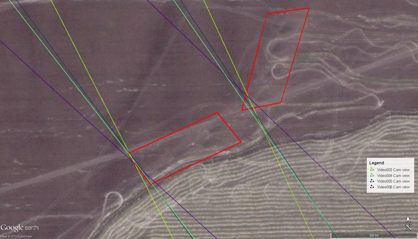
Table of Contents
Table of Contents........................................................................................................................................................... i
Summary ........................................................................................................................................................................... 1
Introduction......................................................................................................................................................................2
Research methods and sources .............................................................................................................................3
The Amvrosiivka attack 14 July 2014 ...................................................................................................................5
Artillery attacks in the Chervonopartyzansk region 14 July to 8 August 2014 .............................. 10
    The Dolzhanskaya-Capital mine/Panchenkove attacks 14 July 2014 to 8 August 2014 ..... 11
    The firing position near Gukovo ...................................................................................................................... 17
    Video footage of the aftermath of the attacks ......................................................................................... 25
The Khmelnytskyi attack 25 July 2014 ............................................................................................................. 28
Conclusion ......................................................................................................................................................................31
Acknowledgments ..................................................................................................................................................... 32

                                                                                          i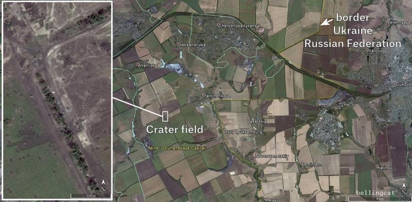
Summary
Ukrainian armed forces positioned near the Russian-Ukrainian border were attacked by
artillery fire in the summer of 2014. Between 9 July and 5 September 2014, the Ukrainian
Border Service and the National Security and Defense Council reported more than 120
artillery attacks from Russia. Russian officials, however, have denied the existence of any
artillery attacks on Ukraine originating from its territory.

The pressure of sustained artillery attacks through early August led Ukrainian armed forces
to lose control of hundreds of kilometers of border territory 1. Google Earth satellite images
of eastern Ukraine from July, August, and September 2014 have enabled the Bellingcat
investigation team to find evidence of these artillery attacks, determine their origin, and
compare them with local sources.

After reviewing and analyzing these satellite images as well as videos from social media,
local media reports, and the shifting maps of the ongoing conflict, the Bellingcat
investigation team has determined that there is compelling evidence that artillery attacks on
Ukrainian territory and against Ukrainian armed forces originated from the territory of
Russia.

1
 http://russian.rt.com/article/43677#ixzz39JNVe6AU;
http://web.archive.org/web/20150210142502/http://russian.rt.com/article/43677

                                               1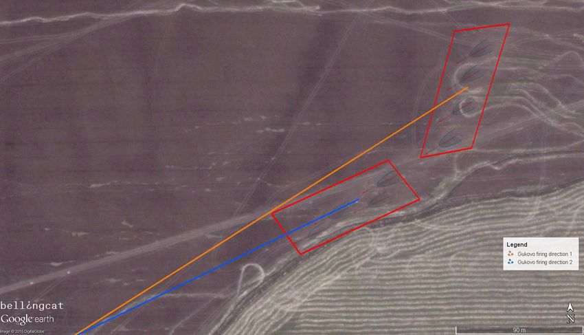
Introduction
In July 2014, Ukrainian armed forces launched an “anti-terrorist operation” against pro-
Russian separatists and made significant territorial gains in eastern Ukraine, regaining
control over a large portion of the Russian-Ukrainian border.

    The situation in the eastern regions of Ukraine on 11 July 2014. Image courtesy of the National Security and
                                                                        2
                                            Defense Council of Ukraine .

However, on the morning of 11 July 2014, the situation suddenly changed. A massive and
unexpected artillery attack on units in the Zelenopillya region killed 30 and wounded over
100 soldiers3. In the days and weeks that followed, the units at the border were subjected to

2
  http://www.rnbo.gov.ua/files/2014/RNBO_map_11_07_eng.jpg;
http://web.archive.org/web/20150210142635/http://www.rnbo.gov.ua/files/2014/RNBO_map_11_
07_eng.jpg
3
  http://www.interpretermag.com/ukraine-liveblog-day-144-30-ukrainian-soldiers-killed-near-
russias-border/;

                                                          2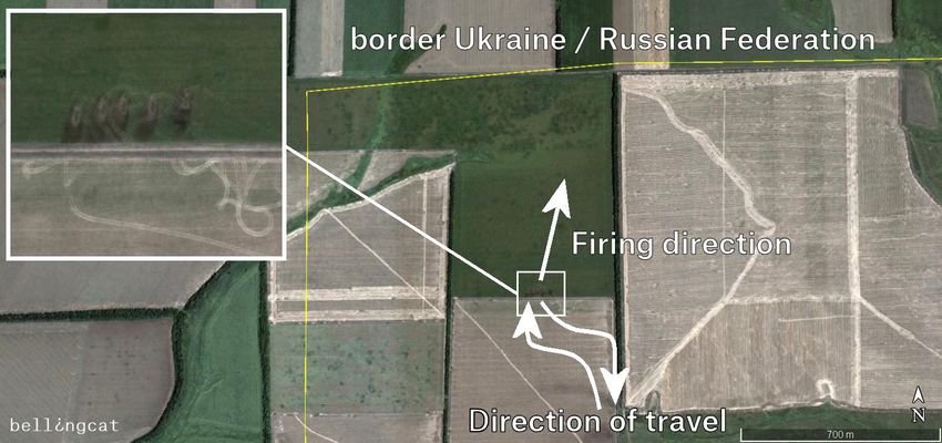
dozens of additional artillery attacks. By late July 2014, the massive bombardment reversed
Ukrainian gains and contributed to the encirclement of portions of the Ukrainian armed
forces. A separatist offensive across eastern Ukraine began simultaneously with the artillery
attacks, leading to the separatists capturing much of the Russian-Ukrainian border along
with vast areas of the Donetsk and Lugansk oblasts.

Artillery attacks on Ukrainian forces near the border proved to be an important factor in
turning the conflict in favor of the separatists. Using in-depth analysis of satellite imagery
and social media sources, this Bellingcat investigation brings new evidence to help clarify to
the origins of these artillery attacks against Ukrainian armed forces.

Research methods and sources
The starting point for this Bellingcat investigation was the distribution of updated satellite
imagery from Google (DigitalGlobe satellite imagery) with a panchromatic resolution of
0.5m from the territory of eastern Ukraine and its border regions with Russia (17 July to 31
August 2014 satellite images). Additionally, the Bellingcat investigation team analyzed
videos shared on social media (YouTube and VKontakte) and geolocated the events
captured in these videos to key sites involved in the artillery attacks on Ukraine.

From the satellite imagery, the Bellingcat investigation team located artillery impact crater
fields from artillery fire and conducted extensive analysis on a crater-by-crater basis. In the
examination of each area, our team created a novel analysis method based on
internationally-recognized ‘on-the-ground’ procedures to determine the trajectory of the
artillery fire.

                                          4                                                 5
           Figure J-3 side-spray method                 Figure J-6 splinter groove method

http://web.archive.org/web/20140711204743/http://www.interpretermag.com/ukraine -liveblog-
day-144-30-ukrainian-soldiers-killed-near-russias-border/
4
  http://www.globalsecurity.org/military/library/policy/army/fm/6-50/Appj.htm#figj_3;
http://web.archive.org/web/20020215215239/http://www.globalsecurity.org/military/library/polic
y/army/fm/6-50/Appj.htm

                                                3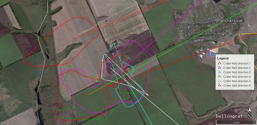
The satellite images from eastern Ukraine show two main types of craters, low-angle fuze
quick craters (with distinctive ‘side spray’ areas projecting diagonally from a central crater)
and high-angle shell craters (triangular-shaped craters that spread outwards towards the
origin of fire):

        Low-angle fuze quick craters (e.g. low-angle artillery or Multiple Launcher Rocket Systems fire)

          High-angle shell craters (e.g. mortars, high-angle Multiple Launcher Rocket Systems fire)

Both types of craters are suitable for determining the trajectory of artillery fire. In reality, the
trajectory of the projectile is determined by a variety of factors, such as the type and
hardness of the ground struck, wind direction and speed, and the type of projectile. Our
team adopted a simple linear trajectory in our analysis, but the actual trajectory may vary
somewhat due to these factors.

5
 http://www.globalsecurity.org/military/library/policy/army/fm/6-50/Appj.htm#figj_6;
http://web.archive.org/web/20020215215239/http://www.globalsecurity.org/military/library/polic
y/army/fm/6-50/Appj.htm

                                                        4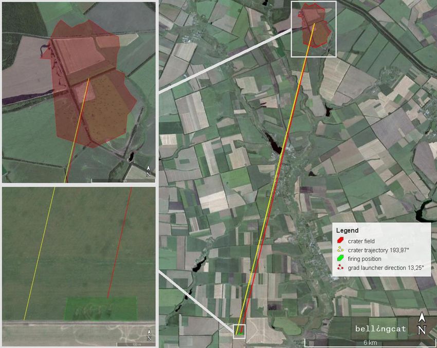
The Amvrosiivka attack 14 July 2014
In a 14 July 2014 summary of the “anti-terrorist operation,” Ukrainian media reported that an
attack took place on positions of the Ukrainian armed forces in the vicinity of Amvrosiivka 6.
It was suspected that the origin of this attack was from the territory of Russia 7.

On the satellite image below, taken on 16 July 2014, an extensive crater field south of
Amvrosiivka is visible, located at the coordinates 47°45'52.38"N 38°30'47.65"E.

    The crater field near Amvrosiivka from the 14 July 2014 attack, positioned at 47°46'1.07" N 38°30'43.16" E.
                                 Google Earth satellite image date 16 July 2014.

The Bellingcat investigation team counted a total of 330 craters in this crater field and
determined the observable direction of each impact crater based on the analysis methods
previously described. From these 330 craters, the average trajectory was calculated and was
determined to be 193.97°, i.e. from the south-south west (180 ° being due south). When
screening for possible firing positions from this trajectory, the Bellingcat investigation team
found a firing position 14.6km from the crater field. Burn marks are visible at this location,
which is on Russian territory and approximately 750m from the border near the Russian
village of Seleznev at the coordinates 47°38'13.52"N 38°28'9.69"E.

6
  https://en.informnapalm.org/anti-terrorist-operation-summary-for-july-14-2014/;
http://web.archive.org/web/20150210142924/https://en.informnapalm.org/anti-terrorist-
operation-summary-for-july-14-2014/
7
  https://www.facebook.com/v.parasyuk/posts/675221185878989

                                                         5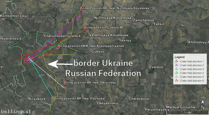
Crater field and firing position, viewing north-north-east

Based on our crater analysis, we judge that these were very likely the five firing sites that
caused the craters near Amvrosiivka. There are several pieces of evidence that lead us to
believe that these strikes were carried out by five 122mm BM-21 Grad or 9K51M Tornado-G
Multiple Rocket Launcher Systems (MLRS) as opposed to the BM-27 Uragan, BM-30
Smerch, or other types of field artillery.

It is well known that BM MLRS create large areas of smoke behind them during and after
firing. Many examples of this are available online8. This area of intense smoke and heat
results in burned/singed ground behind the MLRS and are visible from Google satellite
images. Such burned areas are visible at the firing position considered for the Amvrosiivka
attack, and so we judge that these were very likely MLRSs.

8
    https://www.youtube.com/watch?v=ly6_2ojur0Q

                                                     6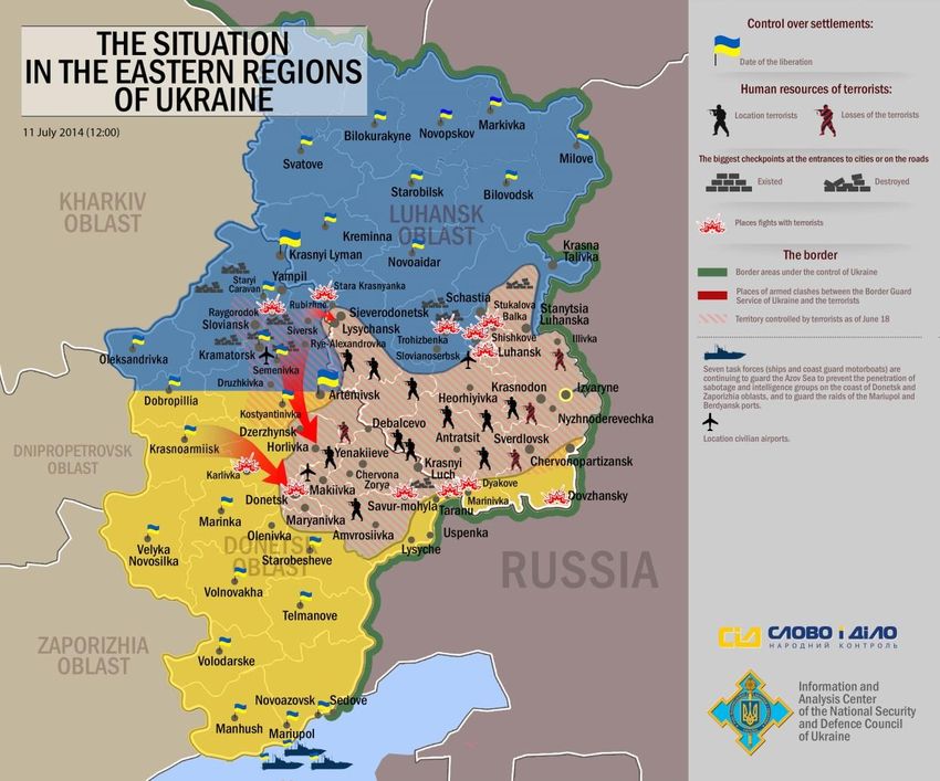
Firing position near Seleznev. Position: 47°38'14.38"N, 38°28'9.77"E.
                               Google Earth satellite image date 16 July 2014.

Analyzing the satellite imagery of the firing position also gave us evidence for determining
the type of MLRS most likely used to conduct the artillery attack.

              The visible tracks that lead to the site come from farther inside Russian territory.

The tracks of the vehicles that entered and exited the field to reach their firing positions are
visible from the satellite imagery. This leads us to believe that there was no cross-border
(Ukraine to Russia) movement of military equipment for this particular location.

                                                        7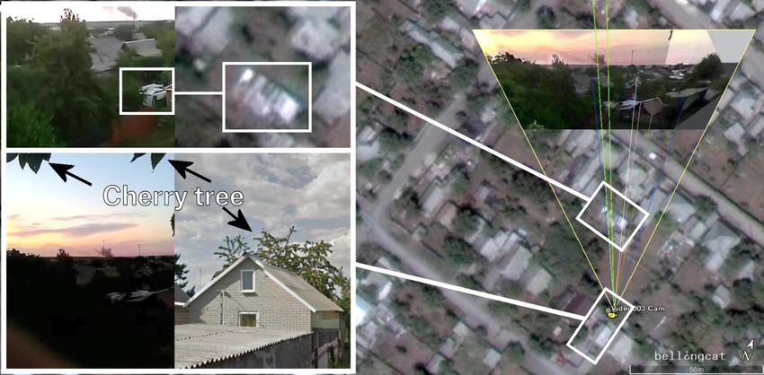
Three MLRS systems are primarily used by the Russian military (see Russian MLRS
systems figure below).

                                     Russian MLRS systems

The measurement of the average track width from the satellite images yielded an average
value of 2.40m. As the resolution of the satellite images is 0.5m, the tolerance for this
measurement is 1.9 to 2.9m. In comparison, the widths of the BM-21/Tornado-G, BM-27,
and BM-30 are 2.4, 2.8, and 3.1m, respectively. The track width determined from satellite
imagery is suggestive of a smaller vehicle, but because of the potential error due to imagery
resolution, this is not conclusive.

Using the satellite images, we were able to determine the turning radii of the vehicles. The
smallest turning radius was measured as 14m. The BM-27 and BM-30 MLRSs have two
steered front axles, so if they were used in this instance, we would expect to see evidence of
two overlapping sets of wheel tracks in the turns leading to or from the firing position.
However, the satellite image shows only the traces of one clear, single track. Based on this

                                               8
evidence, we conclude with high probability that a BM-21 Grad or 9K51M Tornado-G was
used for this attack.
The spacing between, and the sizes of the types of MLRS units judged to be at the firing position
The visible traces of the vehicles also fit well for the typical spacing of BM-21/Tornado-G
systems in battle formation (see the image above for the spacing of the units visible from
the satellite image). According to Army Field Manual No. 100-2-3,9
The BM-21 launcher can be traversed through 180º and the bank of 40 launcher tubes
elevated from 0 to +55º electrically or manually. The rockets can be launched singly at
any desired time interval by manual means or in partial or complete salvo at a fixed 0.5-
second time interval from within the cab or up to 60 m away from the cab with the aid
of a remote-control unit connected to the vehicle by a cable. The rockets must be fired
with the launcher parked obliquely to the target to prevent blast damage to the
unshielded cab.
Our investigation of this attack shows that the average trajectory of the craters pointed
toward the direction of the suspected firing positions with a high degree of accuracy; the
maximum-to-minimum deviation of the analyzed crater angles is only 0.2%. Additionally, a
measurement in the other direction, extrapolating the trajectories of the visible burn marks
at the firing position, revealed that the trajectories led directly to the center of the artillery
crater field.
9
https://www.fas.org/irp/doddir/army/fm100-2-3.pdf
9Artillery attacks in the Chervonopartyzansk region 14 July
to 8 August 2014
In early July 2014, units from the 72 nd Motorized Brigade, the 79th Airmobile Brigade, the 24th
and 51st Mechanized Brigades, and elements of the 3 rd Separate Special Forces Regiment
were tasked with securing the Russian-Ukrainian border south of the separatist-held towns
from Marynivka to the Izvaryne checkpoint. This area, covering over 150km of border, was
known as “Sector D”10.
From the end of the ceasefire on 1 July until 11 July, Ukrainian units advanced quickly and
found relatively little resistance until they reached the Chervonopartyzansk/Gukovo
checkpoint. Then, the situation changed dramatically. The Zelenopillya artillery attack
against Ukrainian forces on 11 July was followed by artillery attacks against large
conglomerations of Ukrainian units in the area close to the Dolzhanskaya-Capital mine and
Panchenkove, Chervonopartyzansk, Khmelnytskyi, Biryukove, Dolzhanskyi border control
point and the Dyakove region. As the world diverted their attention on the horror of the
Malaysian Airlines Flight 17 (MH17) shoot down on 17 July, the situation sharply deteriorated
for the Ukrainian units on the eastern border.
On 22 July, Dmytrivka, a town on the supply road to Sector D, came under attack from
separatists11. For the next two weeks, transport along the roads east of these towns greatly
limited resupply and reinforcement for the trapped units 12,13,14. From interviews and media
reports, it was evident that conditions were dire15,16. Despite this, the units on the border
continued to hold their positions.
10
http://www.thedailybeast.com/articles/2014/08/12/ukrainian-troops-retreat-from-russian-
border-leaving-100-kilometers-defenseless-against-invasion.html;
http://web.archive.org/articles/2014/08/12/ukrainian-troops-retreat-from-russian-border-leaving-
100-kilometers-defenseless-against-invasion.html
11
http://uacrisis.org/lysenko2-22-07-2014/;
http://web.archive.org/web/20141129002451/http://uacrisis.org/lysenko2-22-07-2014/
12
http://maidantranslations.com/2014/07/24/dmitry-tymchuks-military-blog-summary-july-23-
2014/;
http://web.archive.org/web/20141206131810/http://maidantranslations.com/2014/07/24/dmitry -
tymchuks-military-blog-summary-july-23-2014/
13
http://maidantranslations.com/2014/07/27/towns-in-donbas-have-been-liberated-thanks-to-
the-72nd-and-79th-brigades/ ;
http://web.archive.org/web/20141206184958/http://maidantranslations.c om/2014/07/27/towns-
in-donbas-have-been-liberated-thanks-to-the-72nd-and-79th-brigades/
14
http://mignews.com.ua/sobitiya/inukraine/3342474.html;
http://web.archive.org/web/20150210143339/http://mignews.com.ua/sobitiya/inukraine/334247
4.html
15
http://mignews.com.ua/sobitiya/inukraine/3363561.html;
http://web.archive.org/web/20150210143455/http://mignews.com.ua/sobitiya/inukraine/3363561
.html
16
https://www.youtube.com/watch?v=IX6e3wr34BM
10On 3 August, a breakthrough by Ukrainian units in the west unblocked a potential resupply
route (between Dyakove and Dmytrivka) to the beleaguered units on the border17. That same
day, pro-Russian forces sharply increased the number of attacks against the trapped units
on the border18. Out of ammunition, on 4 August, over 400 Ukrainian soldiers from the 72 nd
Mechanized Brigade fled across the border to escape the constant bombardment19. By 8
August, the remainder of the 72nd and 79th brigades had broken out of the encirclement, and
around 1,000 survivors were able to regroup with other units near Savur-Mohyla20.
Significant artillery attacks upon Ukrainian units in the border region east of Dmytrivka were
undoubtedly a key factor in the retreat of Ukrainian units from Sector D. However, until now,
the trajectories and firing positions of the artillery attacks that led to this defeat have not
been analyzed. In the following section, we analyze two of the largest visible artillery attacks
close to Chervonopartyzansk and Sverdlovsk, where Ukrainian units were hit by hundreds of
visible artillery shells during July and August 2014.
The Dolzhanskaya-Capital mine/Panchenkove attacks 14 July 2014 to
8 August 2014
On 14 July 2014, consistent accounts emerged in both Ukrainian and pro-Russian media
outlets that clashes took place in the vicinity of a mine called ‘Dolzhanskaya-Capital,’ close
to the Ukrainian town of Panchenkove21,22.
17
https://en.informnapalm.org/anti-terrorist-operation-ukraine-summary-august-4-2014/;
http://web.archive.org/web/20150210143548/https://en.informnapalm.org/anti-terrorist-
operation-ukraine-summary-august-4-2014/
18
http://euromaidanpress.com/2014/08/05/dmitry-tymchuks-military-blog-summary-august-4-
2014/;
http://web.archive.org/web/20141208115423/http://euromaidanpress.com/2014/08/05/dmitry-
tymchuks-military-blog-summary-august-4-2014/
19
http://www.bbc.com/news/world-europe-28652096;
http://web.archive.org/web/20141229035005/http://www.bbc.com/news/world -europe-
28652096
20
http://www.thedailybeast.com/articles/2014/08/12/ukrainian-troops-retreat-from-russian-
border-leaving-100-kilometers-defenseless-against-invasion.html;
http://web.archive.org/articles/2014/08/12/ukrainian-troops-retreat-from-russian-border-leaving-
100-kilometers-defenseless-against-invasion.html
21
http://www.dtek.com/ru/media-centre/press-releases/details/v-dtek-sverdlovantratsit-v-
rezuljtate-boevikh-dejstvij-obestocheni-dve-shakhtoplosshadki;
http://web.archive.org/web/20150210143935/http://www.dtek.com/ru/media-centre/press-
releases/details/v-dtek-sverdlovantratsit-v-rezuljtate-boevikh-dejstvij-obestocheni-dve-
shakhtoplosshadki#.VNoYQixcpjA
22
http://www.gazeta.ru/social/news/2014/07/16/n_6315585.shtml;
http://web.archive.org/web/20141025100221/http://www.gazeta.ru/social/news/2014/07/16/n_6
315585.shtml
11Crater fields near Dolzhanskaya-Capital mine
Considerable disruptions to the mine’s power system affected pumps and the ventilation
system, leading to the evacuation of 278 miners.
The satellite image from 8 August shows the cause of the power outage: large amounts of
artillery fire that destroyed several electricity poles in the vicinity of the mine. Analysis of the
damaged electricity poles and their connections suggested that only lines leading directly to
the mine were affected. Therefore, there was no evidence to suggest that power to nearby
towns was disrupted due to this attack.
The Bellingcat investigation team researched media reports from mid-July to confirm
attacks from this time period. Official Ukrainian government sources reported artillery
attacks on 23 July and 1 August23, and Ukrainian media sources also reported attacks in this
area on 16 and 24 July, and from 1 to 4 August24. The following comparison of maps
provided by separatist sources shows the course of the battles in July and August
throughout the region and also suggests several specific dates for attacks on Ukrainian
forces25.
23
http://mediarnbo.org/?lang=en;
http://web.archive.org/web/20150209075216/http://mediarnbo.org/?lang=en
24
http://maidantranslations.com/category/opinions/dmitry-tymchuk/;
http://web.archive.org/web/20141201222146/http://maidantranslations.com/category/opinions/d
mitry-tymchuk/
25
http://warday.su/map/53-karta-boevyh-deystviy-18-22-iyulya.html;
http://web.archive.org/web/20150210144240/http://warday.su/map/53-karta-boevyh-deystviy-
18-22-iyulya.html
12Battles southeast of Sverdlovsk from 11 to 24 July (map from pro-Russian websites)
Battles southeast of Sverdlovsk from mid-July to early August (map from pro-Russian sites)
The Bellingcat investigation team analyzed a number of videos shared on YouTube and
VKontakte (VK), Russia’s most popular social networking site. From these sources, it was
established that at least two attacks occurred on 16 July.
Next, our team analyzed the crater field near the Dolzhanskaya-Capital mine outside of the
Panchenkove village by using satellite imagery from 8 August 2014. A total of 813 craters
were measured.
13Crater fields near the Dolzhanskaya-Capital mine
Analysis of the calculated trajectories in the crater field reveals that there were six separate
attacks from five different directions.
Crater fields near the Dolzhanskaya-Capital mine showing six separate firing trajectories
With maximum differences of 300m at a shelling distance of 15km, all of the calculated
trajectories can be traced to five separate firing positions. Every one of these – with the
exception of the position near Chervonopartyzansk, Ukraine, which is close to the border – is
clearly within the territory of Russia.
14The firing positions, from north to south, were located in the following positions:
1. Near Nizhnyaya Kovalevka, Russia at 48°07'51.4"N, 39°54'02.4"E
2. Near Chervonopartyzansk, Ukraine at 48°03'03.2"N, 39°49'52.2"E
Firing position near Nizhnyaya Kovalevka, Russia Firing position near Chervonopartyzansk, Ukraine
3. Near Pavlovka, Russia at 47°56'28.1"N, 39°49'12.0"E
4. Near Ukrainskiy, Russia at 47°58'23.0"N, 39°51'01.5"E
Firing position near Pavlovka, Russia Firing position near Ukrainskiy, Russia
The one exception was a firing position located near Chervonopartyzansk, within the
territory of Ukraine.
5. Near Gukovo, Russia at 48°05'25.0"N 39°54'45.3"E
15The firing position near Gukovo is particularly noteworthy, because numerous videos
have been shared on social media showing artillery fire. The firing position shown in
these videos will be examined separately in the following section.
Crater fields near the Dolzhanskaya-Capital mine – located firing positions
The Bellingcat investigation team has also found that at all of the firing positions except one
(Chervonopartyzansk), vehicle tracks show both an arrival from and departure to areas
within Russia. In other words, in four out of five cases, there were no observable tracks
linking the firing positions to Ukrainian territory, and all the observable tracks near the firing
sites were exclusively within the territory of Russia.
16The firing position near Gukovo
On 17 July 2014, a series of videos were shared on YouTube and VK showing an attack with
MLRSs. The attack occurred on 16 July in the vicinity of Gukovo, Russia. This attack has
already been geolocated by a number of blogs and articles, for example by The Interpreter26.
The Bellingcat investigation team has found six videos on social networks that show the
events of 16 July near Gukovo. Two of these videos were captured from the edge of the
Kovalevsky pond on the afternoon of 16 July.
Video001
г. Гуково (РФ), град бьет по Украине
“City of Gukovo (RF), a Grad strikes at Ukraine”
added 16 July 2014
Camera location: 48°4'30.76"N 39°55'36.94"E
https://www.youtube.com/watch?v=nuar9RkYCR
A
Alternative link:
https://www.youtube.com/watch?v=6SIDxVxdIjw
Video001 shows several MLRS salvos west of the pond. This video has been successfully
geolocated a number of times by various journalists, bloggers, and open source
investigators27.
Video002
Обстрел ГРАДами территории Украины. г. Гуково,
Ростовская область.
“Bombardment of the territory of Ukraine with Grads,
city of Gukovo, Rostov oblast“
16.07.2014, 17.05 (MSK)
added 16 July 2014
Camera location: 48° 4'15.08"N 39°55'24.16"E
https://www.youtube.com/watch?v=GC_pCuqmOm0
Alternative link:
https://www.youtube.com/watch?v=zRCjUPa7qHU
Video002 shows burning fields northwest of the same pond that appears in Video001. It
was suspected at the time that this fire came from MLRS launchers28.
26
http://www.interpretermag.com/ukraine-liveblog-day-149-russian-tanks-and-artillery-reach-
donetsk/;
http://web.archive.org/web/20150108053731/http://www.interpretermag.com/ukraine-liveblog-
day-149-russian-tanks-and-artillery-reach-donetsk/
27
http://ukraineatwar.blogspot.dk/2014/07/russian-Grad-firing-from-russian-soil.html;
http://web.archive.org/web/20150115124112/http://ukraineatwar.blogspot.nl/2014/07/russian-
grad-firing-from-russian-soil.html
17Other Grad rocket volleys were documented in four other videos on the same day in the
evening. Each of these videos was captured exactly at sunset, leading to our determination
that the videos were captured at approximately 19:15 (MSK, local time) 29.
An important feature of this collection of videos is that each was captured from different
angles facing the firing position. The Bellingcat investigation team was able to precisely
determine the location of the firing position from the exact locations of the cameras and the
angle and positions of the Grad launchers in each video.
Video003
Град в Гуково
“Grad in Gukovo”
added 16 July 2014
Camera location: 48°03'59.0"N 39°55'36.2"E
https://www.youtube.com/watch?v=XUUzNnGGbSk
Alternative Link:
https://www.youtube.com/watch?v=edE_FshuF2U
Video003 was captured from a cherry tree on a residential plot on Bazarnaya Street 84 in
Gukovo. The identifying features of this video include buildings in the center of the video, the
cherry tree as camera location, and the angle and distance from the firing position.
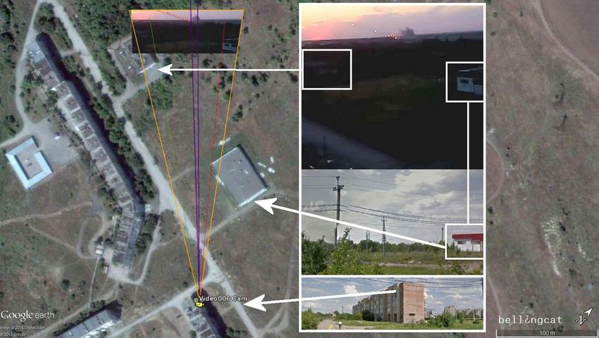
Camera location Video003 – yellow-green lines in the middle point toward the firing position
28
http://www.interpretermag.com/ukraine-liveblog-day-149-russian-tanks-and-artillery-reach-
donetsk/;
http://web.archive.org/web/20150108053731/http://www.interpretermag.com/ukraine -liveblog-
day-149-russian-tanks-and-artillery-reach-donetsk/
29
http://suncalc.net/#/48.05,39.9333,13/2014.07.16/19:15
18Video004
Залп российских ГРАДов из Гуково в сторону
Украины
“Salvo of Russian Grads from Gukovo in the
direction of Ukraine“
added 16 July 2014
Camera location: 48° 4'29.80"N 39°55'36.07"E
https://www.youtube.com/watch?v=8pu0h2O7Rn
I
Alternative link:
https://www.youtube.com/watch?v=8F9WFkA9C
08
Video004 shows the firing position on the southwest side of Kovalevsky pond. The
identifying landscape features in this video are the solitary tree on the right side of the
camera’s perspective, the big bush in roughly the middle of the perspective, and the utility
poles on the far left side of the perspective.
Camera location of Video004 – light green lines in the middle point toward the firing position
19Video005
Град Гуково,Ростовской обл.,Россия по Украине
Russian attacked Ukraine from Gukovo, Rostov
Oblast
added 16 July 2014
Camera location: 48° 4'24.30"N 39°55'37.12"E
https://www.youtube.com/watch?v=kXpCTUjWGk
E
Alternative link:
https://www.youtube.com/watch?v=6ufW8UxbkpM
The firing position in Video005 is visible from the southwest side of Kovalevsky pond. The
identifying landscape features in this video are the same as Video004: a big bush and utility
poles.
Camera location of Video005 – blue lines in the middle point toward the firing position
20Video006
Обстрел территории Украины из Гуково, россия
“Shelling of the territory of Ukraine from Gukovo, Russia”
Added 16 July 2014
Camera location: 48° 3'33.15"N 39°57'22.60"E
http://vk.com/video-38854900_169727129
Alternative link:
https://www.youtube.com/watch?v=TsmcdunS0LA
Video006 was captured from a residential building on Botanicheskaya Street 7a in Gukovo.
The identifying features of this video include a building on the right side of the video,
another building on the left side, the road below, and the angle and distance from the firing
position.
Camera location of Video006 – dark purple lines show the direction of the firing position
21The intersections of the viewing directions to the firing position give the exact location
On the satellite image below, taken 8 August 2014, the intersection of the lines clearly
shows two visible burns, marking the firing position.
The intersection of viewing directions and the location of Grad firing positions
22The positions of the cameras in the previous videos clearly point to a firing position north of
Platovo. These firing positions are visible from satellite imagery of the burned fields (image
above).
As evident from the satellite imagery, there are two visible firing positions for four Grad
MLRSs at 48°05'25.0"N 39°54'45.3"E. The Bellingcat investigation team has measured the
direction of the traces of fire and calculated the trajectory for each firing position.
Trajectories analyzed from the direction of the burn marks
23The calculated trajectories of the burn marks point toward two different crater fields on
Ukrainian territory (image below). After analyzing the individual craters in the artillery strike
site, we found that the calculated trajectories of the firing positions fit almost exactly the
two trajectories determined from the artillery crater analysis of the crater field near the
Dolzhanskaya-Capital mine.
Trajectories from the firing position north of Platovo to the target area around the Dolzhanskaya-Capital mine
Thus, from the evidence of crater field analysis, social media geolocation, and local media
reports, the Bellingcat investigation team has determined that the artillery attacks on the
Ukrainian armed forces positions near the Dolzhanskaya-Capital mine were conducted on
16 July 2014 from firing positions near Gukovo, within the territory of Russia.
24Video footage of the aftermath of the attacks
On 12 August 2014, the separatists, via their so-called “Information and Analysis Agency
South East” posted two videos entitled “Destroyed position of the ‘heroic’ 72nd Brigade APU
near Sverdlovsk, Lugansk region"30.
The Bellingcat investigation team has located the camera position of these videos as being
in the crater field in the vicinity of the Dolzhanskaya-Capital mine31.
A shot from the video
32
“Уничтоженная военная техника под Свердловском 72 бригады ВСУ”
The same destroyed military vehicles are clearly visible in the 8 August 2014 satellite image
from Google Earth, taken just after the Ukrainian forces pulled out of this border area 33.
30
http://real-info.info/novorossiya/razbitye-pozitsii-gerojskoj-72-brigady-vsu-pod-sverdlovskom-
luganskaya-oblast;
http://web.archive.org/web/20140819175725/http://real-info.info/novorossiya/razbitye-pozitsii-
gerojskoj-72-brigady-vsu-pod-sverdlovskom-luganskaya-oblast
31
https://www.google.de/maps/place/48%C2%B001%2753.3%22N+39%C2%B044%2715.5%22E/
@48.0314833,39.7376444,732m/data=!3m2!1e3!4b1!4m2!3m1!1s0x0:0x0
32
https://www.youtube.com/watch?v=X_bpZMKInN4
33
https://pressimus.com/Interpreter_Mag/press/3701;
http://web.archive.org/web/20150210144851/https://pressimus.com/Interpreter_Mag/press/3701
25Camera location for the scene from the video at 1:05
A shot of four damaged Ukrainian vehicles from the video
34
“Уничтоженная военная техника под Свердловском 72 бригады ВСУ”
34
https://www.youtube.com/watch?v=X_bpZMKInN4
26Other shots from the videos
These videos show the extent of the destruction of the Ukrainian forces’ equipment based
close to the Dolzhanskaya-Capital mine. Many heavily damaged trucks and armored
vehicles are visible in the video, including a truck, several BMP-2 units, a self-propelled
artillery unit, BM-21 Grad launchers, and tanks.
27The Khmelnytskyi attack 25 July 2014
On 28 July 2014, the Russian news agency Ruptly published a video on YouTube entitled
"Ukraine: Battle aftermath litters after Sverdlovsk militia pummels 72nd Motorized
Brigade"35.
Shot from the Ruptly Video
Several abandoned and damaged armored vehicles are visible in this video. The video
description also gives us a date for the attack:
Ukrainian Army BMP-2, MT-LB and rocket launchers were left abandoned near
Sverdlovsk on Saturday, after the 72nd Motorized Brigade suffered heavy losses during
mortar shelling from the Lugansk People's Militia on Friday.
Lugansk People's Militia has said that heavy losses were suffered by the Ukrainian
army in both hardware and personnel after the Kiev troops were hit by the 12mm [sic]
mortar shells.
The video was released on 28 July 2014, which means that the day of the attack (the
previous Friday, as mentioned in the description) was 25 July 2014.
Using the video footage, the Bellingcat investigation team has located the camera location
of the Ruptly video as being a crater field close to the village of Khmelnytskyi, south of
Sverdlovsk.
35
https://www.youtube.com/watch?v=kj7sE6dsuW0
28Comparison shot from the Ruptly video and the 15 August 2014 satellite image from Google Earth
Analyzing the satellite imagery, we found a total of 209 craters. We were also able to
determine three primary attack trajectories.
29Result of the crater analysis at the village Khmelnytskyi, south of Sverdlovsk
The trajectories of nine craters point directly east (green line). Two other trajectories (red
and cyan lines) originate from a southeasterly direction. All three trajectories clearly point to
firing positions within Russian territory.
Firing position 1 and military camp Firing position 2 and military camp
Google Earth satellite image date 08 August 2014 Google Earth satellite image date 08 August 2014
These firing positions are directly connected to the military camp of the Russian army near
Pavlovka and a smaller firing position close to Malyy.
30Conclusion
The Bellingcat investigation team used internationally recognized methods and satellite
imagery to analyze a total of 1,353 artillery craters in eastern Ukraine and determine their
trajectories. We located firing positions that closely matched these trajectories, all of which
were inside Russian territory with one exception, which was less than 2km from the Russian
border.
Three artillery attack case studies were investigated in this report: Amvrosiivka (14 July
2014), between Dolzhanskaya-Capital mine and the village of Panchenkove (16 July to 8
August 2014), and Khmelnytskyi (25 July 2014). Our artillery crater analysis concluded that
there were a total of ten primary attack trajectories across all the case studies. We identified
firing positions from each of these attack trajectories. Nine of these firing positions were –
without any doubt – within the territory of Russia, with three being within 400 to 800m of a
military camp. The one position in Ukraine was near Chervonopartyzansk, within the
territory of Ukraine, 1.2km south and 1.5km north of the border with Russia.
The target trajectory of three firing positions was determined through analysis of scorch
marks created by MLRS fire. All three of these trajectories led precisely to the target area of
the crater field, allowing our team to calculate the trajectories in both directions (i.e., from
crater field to firing position and from firing position to crater field). Vehicle tracks are also
visible and clearly showed that they originated from, and led back to, Russian territory near
seven firing positions.
The firing position for an attack on 16 July 2014 in a field north of Gukovo, Russia was
documented in a series of videos found on social media. Four of these videos show the same
instance of 122mm MLRS fire from different perspectives. By comparing the video locations
and views, the Bellingcat investigation team was able to geolocate the exact firing position.
With a small deviation (300m at a shelling distance of 15km), the firing position geolocated
through video analysis was the same as that derived from the crater analysis.
This study has provided compelling evidence that a series of artillery attacks on Ukrainian
territory were conducted between 14 July and 8 August 2014 from firing positions within
Russia. The first attack on 14 July originated from Russian territory near the Russian village
of Seleznev and was directed towards positions of the Ukrainian armed forces south of the
Ukrainian village of Amvrosiivka. Four attacks were conducted near Gukovo, Russia on
Ukrainian armed forces close to the Dolzhanskaya-Capital mine and the village of
Panchenkove between 16 July and 8 August. Two additional attacks were conducted on this
area from Russian territory north of Gukovo. On 25 July, an artillery attack was conducted on
the positions of the Ukrainian 72 nd Mechanized Brigade near Khmelnytskyi village, south of
Sverdlovsk. These attacks also came from locations within Russia, specifically from a
military base in Pavlovka and a position east of the village of Malyy.
31Acknowledgments
Based on the original work of Sean Case
The Investigation team:
Timmi Allen
Sean Case
Eliot Higgins
Veli-Pekka Kivimaki
Iggy Ostanin
Aric Toler
Editorial support provided by Nathan Patin
This report was created collaboratively using Slack.com
32You can also read


