Palm Oil Forest Footprint
North Sumatra, Indonesia
      August 2021
←
→
Page content transcription
If your browser does not render page correctly, please read the page content below
Palm Oil Forest Footprint
North Sumatra, Indonesia
August 2021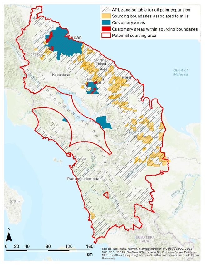
Overview
Over the past 5 years Colgate has had a heightened
focus on the traceability of our palm oil, building the
capacity of our suppliers to meet our policy,
certification of our materials and support of
landscape activities in areas of our supply.

We are accelerating of efforts to better understand No
deforestation, No planting on peat and No
exploitation (NDPE) compliance at the mill level and
evaluate risks to the preservation of forests and
peatlands and the potential risks to the rights of
people and communities touched by our supply chain.
Through a clear understanding of those risks we can
take action to preserve the livelihoods of people and
protect the forests areas they and native species rely
on to survive
Our Forest Footprint presented here focuses on
Colgate-Palmolive’s palm oil supply chain in the
province of North Sumatra, Indonesia. This forest
footprint was conducted in partnership with
Earthworm Foundation.
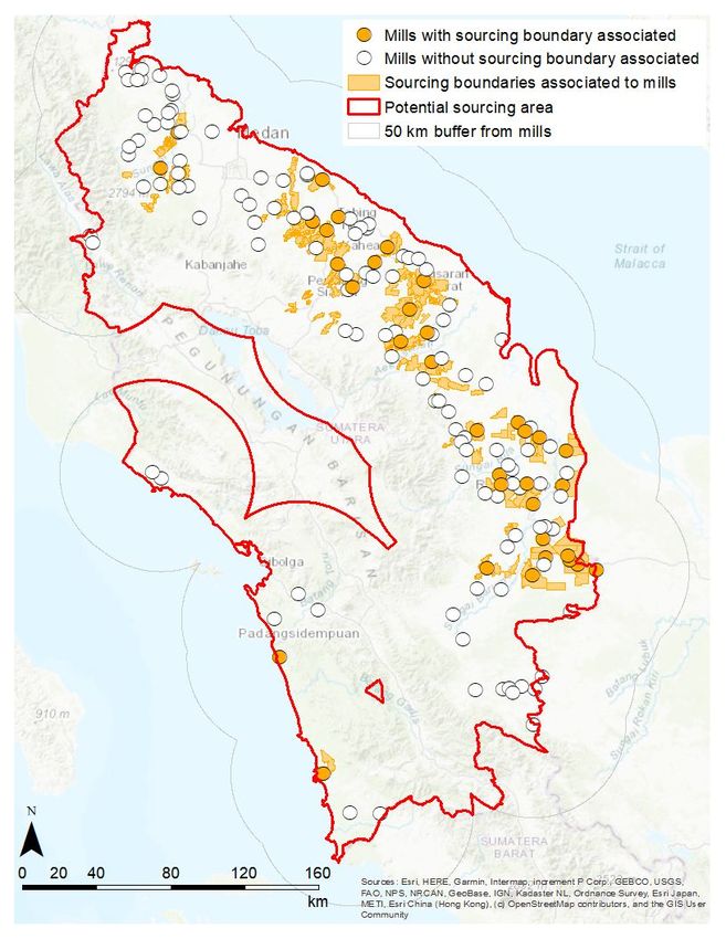
Forest Footprint Methodology
North Sumatra was selected as a focus area for the forest footprint due to its importance as
a sourcing area for Colgate represented by a high concentration of palm oil mills in our
supply chain.

This footprint includes an analysis of mills and sourcing boundaries / concessions (palm oil
plantations or smallholder farms) associated with those mills along with intact forest and
peatland within those concessions or in proximity to mills. Forest and peatlands were
further assessed for increased risk of deforestation or conversion based on suitable terrain
for palm cultivation and land zoning identified for further development.

The analysis also includes identification of known customary lands and the overlap of those
lands with known concessions or within mill sourcing boundaries. This customary land
mapping is important to understand potential impact of further land development on local
communities and at risk land related conflicts.
Forest Footprint Methodology
Colgate together with our partner Earthworm Foundation through the use of the
Starling platform and available public and private data identified forest areas,
peatlands and community lands located within concession boundaries or in proximity
to mills in our supply chain.

The above information was overlaid on the Starling platform with the following mill
information:
 ●   Available sourcing boundaries with confirmed links to mills in our supply chain
 ●   Available sourcing boundaries with unconfirmed links to mills in our supply chain
 ●   Identified a 50km radius around mills in our supply representing the potential sourcing area
     when sourcing boundaries / concessions linked to mills were unknown

We analyzed the number of hectares of remaining forest and peat in proximity to mills
in our supply chain and how this intersects with available customary land boundaries.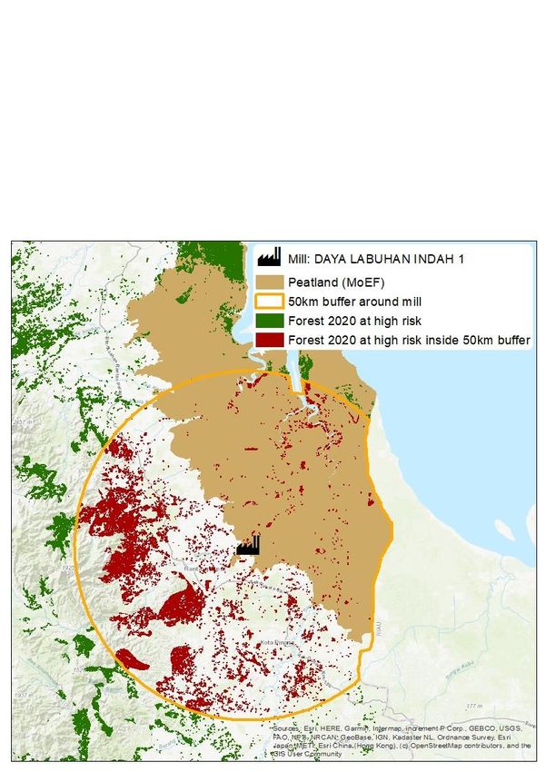
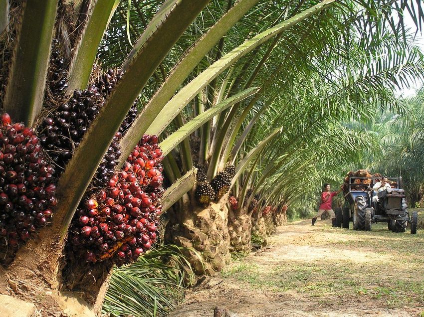
Background on Colgate’s
Supply Chain in North Sumatra
This footprint analysis is based on Colgate’s mill
traceability data from 2020, during which Colgate used
palm oil and palm kernel oil from 149 mills in North
Sumatra.

Of the 149 mills, 35 mills can be linked to known
sourcing boundaries/concessions which are disclosed
per the requirements of their Roundtable on Sustainable
Palm Oil (RSPO) certification.

Known sourcing boundaries/concessions have not been
established for 114 mills, therefore a potential sourcing
distance from mills of 50 km has been established as the
“potential sourcing area”.

The potential sourcing area in North Sumatra represents
90% of the province or 6,079,502 ha

North Sumatra has an area of oil palm plantation of over
1 million hectares, of which 19% exists within the known
concessions linked to mills in Colgate’s supply chain
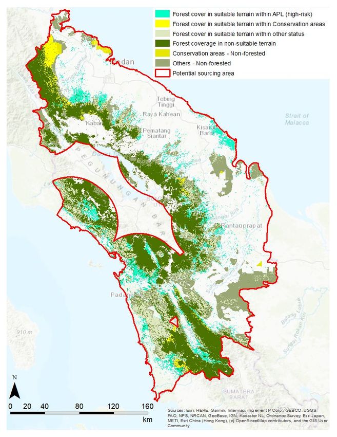
Forest Area Analysis
Findings
2,232,818 ha of forest remains within the potential palm oil
sourcing area.

39% (877,475 ha) of the remaining forest falls within suitable
terrain in terms of slope and altitude for oil palm expansion.
● terrain suitable for oil palm plantations defined as the terrain with an
  altitude < 700 m above sea level and a slope < 40%:
● 36% (315,891 ha) of the forest present in suitable terrain for oil palm
  expansion falls within another utilization areas (APL). We consider this
  extent of forest to be under high-risk to be transformed to other land
  use.

Limitations
Some information is missing to make the data more robust
including:
●   Clear sourcing linkages between mills and plantations
●   Mill capacity data
●   Clear identification of parent companies for mills and plantations
●   Traceability to Plantation (TTP) information, including access to full
    plantation boundaries for smallholder-owned and company-owned
    estates and percentage of a mill volume coming from smallholders
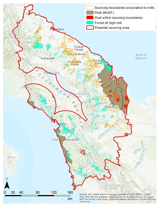
Peatland Area Analysis
Findings
7% (37,843 ha) of peatland area is forested of
which 70% (26,868 ha) is at high-risk
71% (368,706 ha) of peatland as identified by the
Ministry of Environment and Forestry (MoEF) is
not classified as oil palm plantations, 6% (24,690
ha) of which remains within sourcing boundaries

Limitations
More accurate peatland data is needed, including
peatland mapping, moratorium areas inside and
outside concessions, restoration plans or
rezoning of lands in ‘Another Utilization Area’
(APL)
Customary Lands Analysis
Findings

Within the ‘potential sourcing area, 6%
(345,885 ha) are classified as customary
areas of which 4% (14,934 ha) fall within
known concessions.

Limitations

A more complete mapping of customary
forest areas is needed, including additional
information on usage rights, land rights
concerns and existing conflicts.
Specific examples and how data will be used
Working with suppliers on high risks
We will be working with our direct suppliers to
collaborate on preventing deforestation or
exploitation linked to the mills in our supply
chain in North Sumatra.
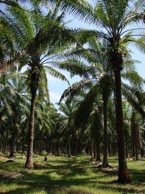
The mill pictured to the left has within its 50 km
buffer over 300,000 ha’s of forest and peat at
risk. The mill is owned by a company with an
NDPE policy commitment, but is not RSPO
certified. These factors would make it a high
priority for Colgate to understand the
safeguards in place to ensure the mill’s actual
sources are not contributing to deforestation or
land related conflicts.Activities to date and Next Steps We continue to engage with our direct suppliers on NDPE implementation, traceability and transparency. Through landscape and jurisdictional projects with our suppliers, peers and industry partners we hope to transform not just our supply chain but the palm oil industry. As a member of the Consumer Goods Forum - Forest Positive Coalition; through implementation of the Palm Oil Roadmap we have committed to addressing deforestation across forest risk commodities and have aligned this with our own 2025 goal to strive for net zero deforestation. Learnings from this forest footprint will enable us to focus our engagement on prioritizing upstream mills and producers at risk for future deforestation and land associated conflicts. We are finalizing our action plan, and will be working with our suppliers to prioritize mills at highest risk. Additionally, we expect to achieve greater visibility of concessions sourcing to mills in our supply chain and better understand actions mill companies are taking to manage risk of deforestation or conversion of forests or peatlands as well as actions they are taking to respect customary lands and local communities through processes such as FPIC (free, prior and informed consent). We also see work from this footprint helping to inform our strategy on future landscape engagement through which we can support producers and key stakeholders to implement forest positive practices and protect human rights.
Appendix - Date Sets Used
Data used:

•   Land cover data from 2001 to 2020. Source: Starling (https://www.starling-verification.com)

•   Altitude data (2014). Source: SRTM 1 Arc-Second global (https://earthexplorer.usgs.gov/)

•   Forest zones. Source*: Ministry of Environment and Forest – Government of the Republic of
    Indonesia (MoEF – GoI; http://geoportal.menlhk.go.id/arcgis/rest/services)

•   Customary land (2020). Source: BRWA (https://brwa.or.id/)

•   Social and rural forest*. Source: MoEF – GoI (http://geoportal.menlhk.go.id/arcgis/rest/services)

•   Peat ecological function*. Source: MoEF – GoI (http://geoportal.menlhk.go.id/arcgis/rest/services)

•   Colgate supply chain data (i.e. mills) declared by suppliers in 2020

•   Sourcing boundary data (i.e. identified oil palm plantations) from various public and private sources
You can also read