Persistent effects of sand extraction on habitats and associated benthic communities in the German Bight
←
→
Page content transcription
If your browser does not render page correctly, please read the page content below
Biogeosciences, 18, 3565–3577, 2021
https://doi.org/10.5194/bg-18-3565-2021
© Author(s) 2021. This work is distributed under
the Creative Commons Attribution 4.0 License.

Persistent effects of sand extraction on habitats and associated
benthic communities in the German Bight
Finn Mielck1 , Rune Michaelis1 , H. Christian Hass1 , Sarah Hertel1 , Caroline Ganal2 , and Werner Armonies1
1 Alfred  Wegener Institute, Helmholtz Centre for Polar and Marine Research, Wadden Sea Research Station,
List auf Sylt, 25992, Germany
2 Institute of Hydraulic Engineering and Water Resources Management, RWTH Aachen University, Aachen, 52056, Germany

Correspondence: Finn Mielck (finn.mielck@awi.de)

Received: 21 January 2020 – Discussion started: 20 February 2020
Revised: 26 March 2021 – Accepted: 6 April 2021 – Published: 17 June 2021

Abstract. Sea-level rise demands for protection measures of           tics is unlikely. Since coarse sand is virtually immobile in this
endangered coastlines crucial for the local population. At the        area, a regeneration towards pre-dredging conditions is also
island of Sylt in the SE North Sea, shoreline erosion is com-         unlikely without human interference (e.g., mitigation mea-
pensated by replenishment with sand dredged from an off-              sures like depositing coarse material on the seafloor to restore
shore extraction site. We studied the long-term effects of sand       the sessile epifauna).
extraction on bathymetry, geomorphology, habitats and ben-
thic fauna. Sand extraction created dredging holes about 1 km
in diameter and up to 20 m below the ambient seafloor level.
Directly after dredging the superficial sediment layer, inside        1   Introduction
the pits was dominated by coarse sand and stones. Hydroa-
coustic surveys revealed only minor changes of bathymetry             Sea-level rise, with ever-increasing rates in the near fu-
> 35 years after sand extraction. Obviously, backfill of the          ture, demands protection measures of endangered coastlines
dredging pits was very slow, at a rate of a few millimeters per       crucial for the local population (Nicholls and Tol, 2006;
year, presumably resulting from low ambient sediment avail-           Hinkel et al., 2014). In many cases, ecological awareness and
ability and relatively calm hydrodynamic conditions despite           sustainability considerations have led to the preference for
high wave energy during storms. Thus, a complete backfill of          “soft” coastal protection measures like beach nourishment
the deep extraction sites is likely to take centuries in this area.   over “hard” protection approaches such as dikes or revet-
Hydroacoustic surveys and ground truthing showed that the             ments (Hamm et al., 2002; Pranzini et al., 2015; Staudt et
backfilled material is mainly very fine sand and mud, turn-           al., 2020). As a result, there is a worldwide high demand for
ing the previously coarse sand surface into a muddy habi-             marine aggregates needed especially for coastal protection.
tat. Accordingly, grab samples revealed significant differ-           It has reached a high level on a worldwide scale and fur-
ences in macrozoobenthos community composition, abun-                 ther increase is expected (Hamm et al., 2002; Kubicki, 2007;
dance and species density between recently dredged areas              Danovaro et al., 2018; Schoonees et al., 2019). For the north-
(< 10 years ago), recovery sites (dredging activity > 10 years        ern European continental shelf, the extracted volume rose
ago) and undisturbed sites (control sites). Overall, dredg-           from altogether 53×106 m3 between 1998 and 2002 to a total
ing turned the original association of sand-dwelling species          of 73.2 × 10⁶ m3 in 2018 (ICES, 2016, 2019).
into a muddy sediment association. Since re-establishment                Marine sand extraction changes local bathymetry and sed-
of disturbed benthic communities depends on previous re-              iment composition (De Jong, 2016; Mielck et al., 2018)
establishment of habitat characteristics, the low sedimenta-          and affects macrozoobenthic communities, both directly by
tion rates indicate that a return to a pre-dredging habitat type      killing or removal of benthic organisms during sediment ex-
with its former benthic community and habitat characteris-            traction and indirectly by altering the environmental condi-
                                                                      tions (Boyd and Rees, 2003; Foden et al., 2009). Further in-

Published by Copernicus Publications on behalf of the European Geosciences Union.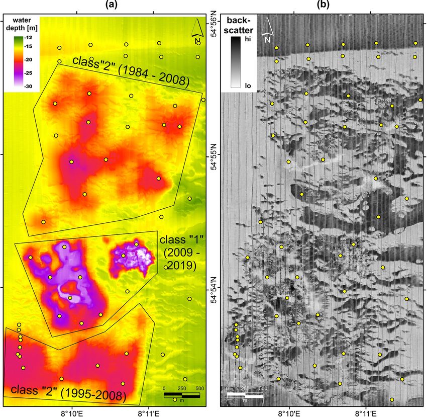
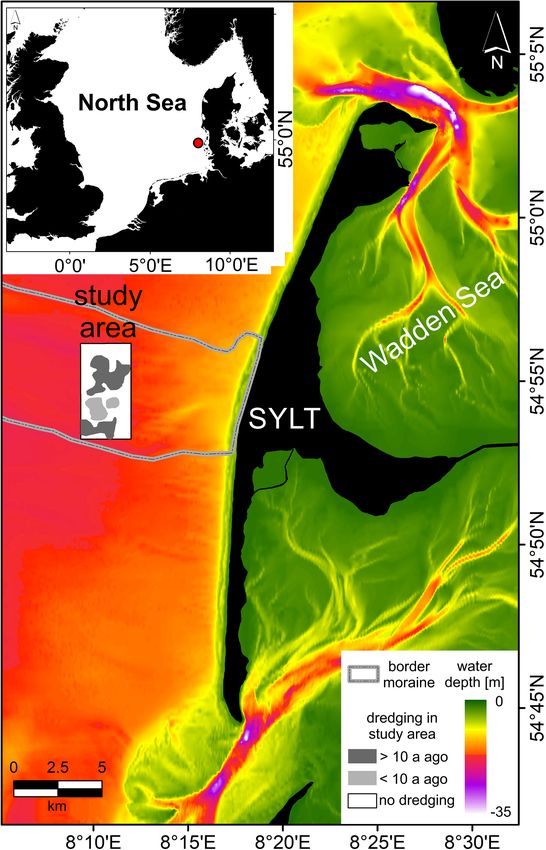
3566                                                       F. Mielck et al.: Effects of sand extraction on benthic communities

direct effects of sediment dredging include increased turbid-       areas surrounding the extraction site were compared for sed-
ity, release of nutrients and toxins, changes in regional mor-      iment and benthic faunal composition. Using hydroacoustics
phodynamics (Le Bot et al., 2010), and smothering of organ-         and sediment grab sampling, maps were created showing the
isms due to sedimentation (van Rijn et al., 2004). Current          sediment characteristics and morphology of the seafloor.
attempts to minimize the area affected by dredging activities          Hydroacoustics have proven very effective for remote
have led to greater extraction depths. However, the ecologi-        sensing seafloor classification and habitat mapping. Multi-
cal effects of deep sand extraction (> 10 m dredging depth)         beam echo sounders give information about water depth and
are still largely unknown (Boyd and Rees, 2003; De Jong             morphology and can thus be used to calculate backfill rates
et al., 2016). Since sedimentological investigations showed         at the extraction pits (Harris and Baker, 2012; Jones et al.,
tremendous change of the physical habitats, it must be ex-          2016; Mielck et al., 2018). Sonar systems such as side-scan
pected that macrozoobenthic communities change at a sim-            sonars allow the investigation of the backscatter intensity by
ilar level (Boyd et al., 2005; Kubicki et al., 2007; Foden et       transmitting an acoustic pulse, which will be reflected by
al., 2010). Whether or not the benthic communities are able         the seafloor and received by a transceiver. Backscatter al-
to recover to their pre-dredging state or remain disturbed or       lows us to distinguish between hard–coarse (strong backscat-
whether new habitats with altered benthic communities are           ter response from the seafloor) and soft–fine substrates (low
developed is crucial information for a holistic assessment of       backscatter response from the seafloor; Blondel and Murton,
the impact of such a coastal defense measure. It is thus es-        1997; Blondel, 2003; Mielck et al., 2012, 2015), which is an
sential to investigate the benthic communities of the affected      additional parameter useful for seafloor classification. Inter-
areas to predict changes in species abundances and the struc-       pretation and verification of sonar data always require ground
ture of the benthic community.                                      truthing, e.g., by sediment samples (for granulometry) and/or
   After sediment extraction, morphological recovery of the         underwater video (Harris and Baker, 2012; Hass et al., 2017).
local environment depends on the ambient sediment avail-               Benthos communities often largely correlate with sedi-
ability and hydrodynamic conditions. Additional crucial fac-        ment composition; however, a precise identification of com-
tors are extraction depth (i.e., deep drilling vs. shallow dredg-   munities is not yet possible by hydroacoustic methods be-
ing) and the amount of material extracted (Cooper et al.,           cause transitional zones between major habitat types may be
2007; De Jong et al., 2015). Re-establishment of the ben-           populated by transitional communities, and these zones are
thic community depends on the progress in morphological             often not detectable by hydroacoustic methods (Markert et
recovery and on the sensitivity and resilience of the dif-          al., 2013). Thus, ground truthing by sediment samples is re-
ferent benthic organisms and communities to anthropogenic           quired to correctly identify the benthic communities.
impact (Desprez, 2000; Cooper et al., 2011). In general, a
full re-establishment of benthic assemblages is possible but
may take a long time and is strongly dependent on sediment          2     Materials and methods
composition, original topography and the connection to sim-
ilar habitats in the proximity (Desprez, 2000; Boyd et al.,         2.1    Study area
2005). In addition, recovery may proceed over intermedi-
ate stages atypical for the original environment, e.g., when        The study area “Westerland Dredging Area” (WDA) is lo-
large amounts of fine materials are deposited in a sandy area       cated in the German Bight (SE North Sea) approx. 7 km
(Boers, 2005).                                                      west off the island of Sylt (Fig. 1). This island suffers strong
   The aim of this study was to further follow the re-filling       erosion, notably along its wave-exposed western side. Since
process of the dredging pits and, as a new aspect, to find out      1972, sediment losses have been compensated for by artifi-
whether and how extensively marine aggregate extraction af-         cial beach nourishments, and the investigated study site has
fects regional macrozoobenthic communities. If local faunal         served as a sand extraction area since 1984 (LKN-SH, 2012).
composition was mainly ruled by larval supply, faunal com-          Most of the seafloor west off Sylt is covered with Holocene
position inside the dredging pits may be similar to ambient         fine sand (Figge, 1981; Zeiler et al., 2000). However, for
sediments. Otherwise, if sediment composition were an im-           shore nourishments coarse- to medium-grained Pleistocene
portant factor, faunal composition in the muddy sediments of        sands outcropping in WDA are preferred (Temmler, 1983,
dredging pits should differ considerably from those in ambi-        1994). These Pleistocene sediments come with gravel and
ent sandy sediments.                                                stones deposited as a moraine core during the Saalian glacia-
   Thus, the main objectives were to (i) gain a deeper under-       tion (∼ 300–126 kyr BP). At the study area, this moraine core
standing of the correlation between the prevailing habitats         strikes in the west-northwest direction (Köster, 1979; see
and the associated benthic assemblages, (ii) evaluate tempo-        Fig. 1). The surface of the seafloor in WDA is characterized
ral recovery patterns along with short- and long-term changes       by bands of coarse-grained rippled sand, so-called sorted
in the community structures and (iii) investigate the potential     bedforms which are very common west off Sylt (Diesing et
of a re-establishment to pre-dredging conditions. Therefore,        al., 2006; Mielck et al., 2018). Most of these bands have a
dredging pits of different ages and, as a control, the sandy        wavelength of ∼ 100 m and strike in the east–west direction.

Biogeosciences, 18, 3565–3577, 2021                                                     https://doi.org/10.5194/bg-18-3565-2021
F. Mielck et al.: Effects of sand extraction on benthic communities                                                            3567

                                                                     tion site in Germany. The study area includes recent dredg-
                                                                     ing zones (younger than 10 years), sand deposits already ex-
                                                                     ploited more than 10 years ago and unaffected seafloor re-
                                                                     gions. Meanwhile, the pits persist for more than 30 years
                                                                     (Mielck et al., 2018). The Pleistocene coarse sands in the
                                                                     pits exposed during sand extraction were rapidly covered by
                                                                     a layer of fine sand due to slides at the steep slopes. The fine
                                                                     sand originates from the immediate seafloor surface around
                                                                     the pits (Zeiler et al., 2004; Mielck et al., 2018). After this
                                                                     initial phase, muddy sediments accumulated, however, due
                                                                     to the combination of a lack of mobile sediments and low
                                                                     transport rates (Valerius et al., 2015), at very low rates only.
                                                                     Accordingly, a complete backfill of the deep dredging pits
                                                                     was estimated to take many decades (Mielck et al., 2018).
                                                                        This research paper is a follow-up to the previous study
                                                                     by Mielck et al. (2018), which focused on morphological
                                                                     changes due to marine aggregate extraction in WDA us-
                                                                     ing bathymetric data collected between 1993 and 2017. For
                                                                     the study presented here, hydroacoustic data and sediment
                                                                     samples were taken using the research vessel Alkor in Jan-
                                                                     uary 2019. In order to acquire overall information on the pre-
                                                                     vailing morphology and high-resolution backscatter data of
                                                                     the study area, altogether 55 transects, each 5.5 km long, with
                                                                     a lateral distance of 50 m were surveyed in the north–south
                                                                     direction at a vessel speed of ∼ 2.5 m s−1 . During the survey,
                                                                     which took place between 25 and 27 January at calm weather
                                                                     conditions, multibeam echo sounder and side-scan sonars
                                                                     were used simultaneously on all transects. Subsequently, 53
                                                                     grab samples for grain size and macrobenthic faunal anal-
                                                                     yses were collected on 31 January. Surveyed transects and
                                                                     position of the grab samples are provided in Fig. 2. Under-
                                                                     water videos could not be acquired as a consequence of high
Figure 1. Study area “Westerland dredging area” (WDA) located        turbidity.
west of the island of Sylt (SE North Sea). Bathymetric infor-
mation was provided by the German Federal Maritime and Hy-
drographic Agency (BSH, German Federal Maritime and Hydro-           2.2   Multibeam echo sounder
graphic Agency, 2018) and our own measurements. Geological data
were modified after Streif and Köster (1978) (subaquatic border of   Bathymetric information of the investigation area was
the Saalian PISA moraine).                                           collected using a shallow-water multibeam echo sounder
                                                                     SeaBeam 1180 (180 kHz; swath width of 150◦ ), which was
                                                                     installed on a plate in the ships’ moon pool. Positioning and
The ripples within the coarse-grained areas do not strike in         motion compensation were done using a Kongsberg SEA-
the same direction as they were most likely formed during            TEX MRU-Z. During the survey three CTD profiles were
storm events (alignment perpendicular to storm direction).           measured (conductivity, temperature, pressure) to calculate
The sorted bedforms are often overlaid by a layer of migrat-         sound velocities. Multibeam data were post-processed using
ing fine sand that leads to the consequence that their shape is      Hypack 2016a and ESRI ArcGIS10, resulting in a bathymet-
frequently altered (Mielck et al., 2015).                            ric map with a grid size of 2 m. For tidal correction, the gauge
   The study area has an extent of ∼ 5 km in the north–              “Westerland Messpfahl” was used, which is located approx.
south direction and ∼ 3 km in the east–west direction. Nat-          6 km east of WDA. Depth values in this study are given in
ural water depths range between ∼ 14 and ∼ 17.5 m while              meters below mean sea level.
the pits left by sand extraction may reach down to 30 m
water depth with diameters of approx. 1 km. Since 1984,              2.3   Side-scan sonar
more than 40 × 106 m3 of sediment has been extracted from
this area using trailing suction hopper dredgers (LKN-SH,            Two different side-scan sonars were deployed simultane-
2012, 2020). With an actual annual material withdraw of 1–           ously to determine backscatter properties (roughness) of the
2 ×10⁶ m3 , this area is the largest offshore sediment extrac-       seafloor across the study area during the survey. The devices

https://doi.org/10.5194/bg-18-3565-2021                                                     Biogeosciences, 18, 3565–3577, 2021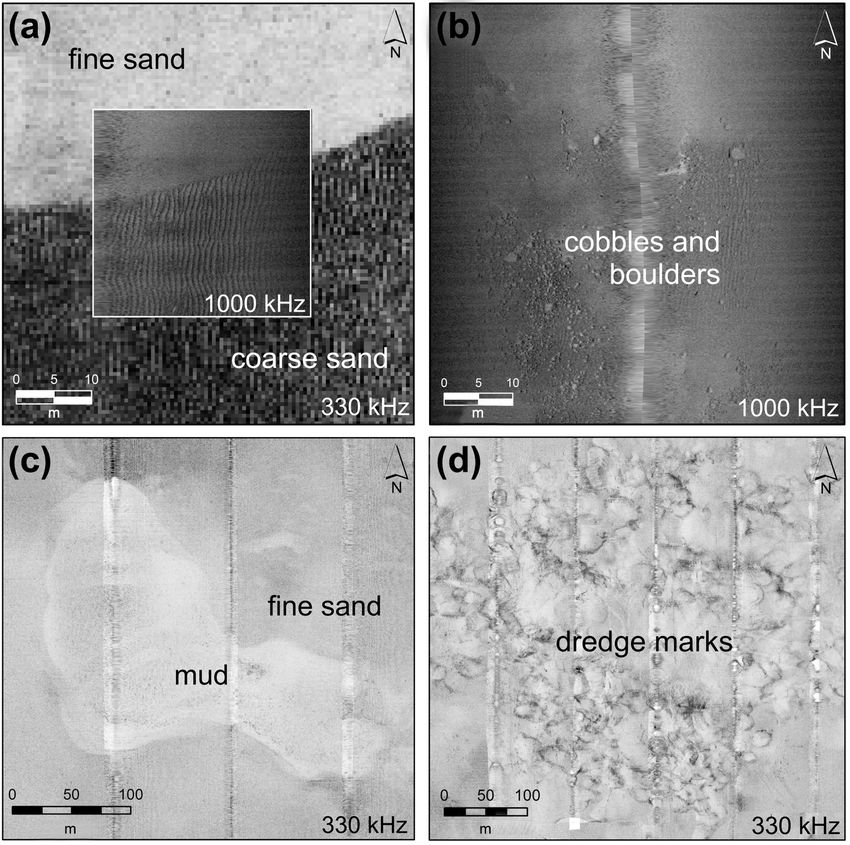
3568 F. Mielck et al.: Effects of sand extraction on benthic communities
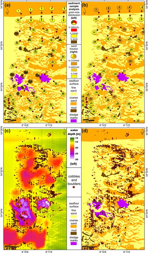
Figure 2. Results of the hydroacoustic survey along 55 N–S transects executed in January 2019. (a) Post-processed bathymetric map of the
study site measured with a multibeam echo sounder; class “1”: sites where sediment was extracted during the past 10 years (1984–2008);
class “2”: sites where sediment extraction was terminated at least 10 years prior to the sampling (2009–2019); class “0”: control sites which
are directly unaffected by dredging (area outside the boxes). (b) Backscatter response of the seafloor recorded with side-scan sonar (here:
330 kHz); dark grey: high backscatter; light grey: low backscatter. Surveyed transects become visible as the longish dark grey stripe in the
side-scan mosaic proceeding in the N–S direction. Positions of grab sample stations are indicated by yellow dots.
were attached to each other and towed behind the vessel to 2015). All recorded side-scan sonar data were post-processed
avoid sound disturbances from the ship. They operated with using SonarWiz 5 (Chesapeake Technology), resulting in a
different frequencies in order to collect backscatter infor- grid resolution of 0.5 m for the YellowFin and 5 cm for the
mation from the seafloor in two resolutions, which provides StarFish. Distinct areas (e.g., fine/coarse sand) and charac-
more detailed data regarding sediment composition and habi- teristic backscatter responses in the sonograms (e.g., stones)
tat characteristics. The first side-scan sonar (Imagenex Yel- were manually digitized using ArcGIS. The size of the stones
lowFin 872) worked with a frequency of 330 kHz, resulting was determined by measuring slant angle and length of the
in a resolution of 12.5 cm per pixel in the digital imaging acoustic shadow using the software EdgeTech Discover. The
while reaching a swath of 160 m on the seafloor. The sec- results of the grain-size analysis were used to relate the
ond side-scan sonar was a Tritech StarFish 990F that op- backscatter intensities to the prevailing sediment distribution.
erated with a frequency of 1 MHz and reached a resolution
of ∼ 1 cm per pixel at a swath of 60 m. Using different fre- 2.4 Grab sampling and analysis
quencies leads to more detailed information on the seafloor
environment. Side-scan sonar data recorded with a low fre- The surface sediments and morphology across WDA are al-
quency generally yield information on large-scale objects on ready well-known from the prior study (Mielck et al., 2018)
the seafloor (e.g., facies changes, sandwaves, megaripples) and were taken as representative for all occurring seafloor
while a high frequency gives more information on small- environments. For ground truthing of hydroacoustic data
scale structures such as ripple marks or stones (Mielck et al., and for macrobenthos analysis, a total of 53 grab samples
were taken using a Van Veen grab (HELCOM; 30 × 30 cm;
Biogeosciences, 18, 3565–3577, 2021 https://doi.org/10.5194/bg-18-3565-2021F. Mielck et al.: Effects of sand extraction on benthic communities 3569
0.1 m2 ). The sampling positions generally followed a regu- 5 m and very low sedimentation rates after the first year; see
lar grid, but some positions were also selected on the basis Zeiler et al., 2004; Mielck et al., 2018).
of the bathymetric information in order to take samples from The side-scan sonar measurements (Fig. 2, right) showed
both the older dredging pits (older than 10 years) and the numerous features across the study area (Fig. 3). Based on
newer ones (see Fig. 1). At two positions, sampling was not these measurements, the seafloor could be classified into four
possible due to very steep slopes or the presence of stones types (Fig. 3).
on the seafloor, respectively, that prevented the sampler from
closing completely. Grain-size analyses were done using a 1. Ground truthing with grain-size analyses of the sedi-
CILAS 1180L diffraction laser particle-size analyzer, which ment (Fig. 4a and b) revealed that high-backscatter do-
provides grain-size information between 0.04 and 2500 µm. mains represent rippled coarse-sand zones (sorted bed-
The statistical parameters (referring to vol %) are based on forms). Intermediate backscatter stands for fine sand.
Folk and Ward (1957) and were calculated using GRADIS- Coarse- and fine-sand zones were often demarcated by
TAT (Blott and Pye, 2001). sharp borders (Fig. 3a). These backscatter patterns dis-
For faunal analyses, a sub-sample of 100 cm2 surface area tinctly coincide with the topography (compare Fig. 2
(max. depth of 18 cm; limited by the Van Veen grab) from left and right), while low dunes were composed of rel-
each of the grabs was fixed in 5 % buffered formaldehyde- atively mobile fine sand (extending in the east–west
in-seawater solution. For faunal analyses this sample volume direction) alternating with shallow troughs where rel-
may be unusually small but we judged it sufficient to find atively immobile coarser sediment is exposed. These
out whether dredging had a strong effect. In the lab, the sam- seafloor features are most pronounced on the undis-
ple was sieved through 1 mm square meshes and the residual turbed seafloor around the dredging pits but also appear
fauna determined to species level and counted. Biomass was to extend into the older and shallower pits, especially in
determined as wet weight per species and sample. For sta- the north of the study area.
tistical analysis, the sampling sites were classified accord- 2. Several thousands of stones with diameters from
ing to their history of sand extraction: class “0” for sites ∼ 10 cm to > 1 m (best seen in the high-resolution data
never impacted by sand extraction and thus serving as a con- set, Fig. 3b) occurred within this rippled coarse-sand
trol for undisturbed conditions, class “1” for the sites where zone while there were virtually no stones present in the
sediment was extracted during the past 10 years and class fine-sand zones or dredging pits (Fig. 4c and d). Stones
“2” for the sites where sand extraction was terminated at in side-scan sonograms are characterized by a strong
least 10 years prior to sampling (see Fig. 2a). These classes dark reflection followed by a bright acoustic shadow.
were used as a categorical variable in univariate analyses of
variances (ANOVAs) to test for effects on macrozoobenthic 3. Extended areas of mud, in the sonograms represented as
abundance, biomass and species density. Significant differ- areas with uniform low backscatter, could only be iden-
ences between the variables were further investigated with tified in the dredging pits in the northern and southern
Scheffe’s post hoc test. Prior to statistical analyses, abun- parts of WDA (Fig. 3c).
dance and biomass data were log(x + 1)-transformed while
the Cochran C test indicated that no transformation was 4. In the center of the study area, where sand extraction is
needed for species numbers. All calculations were done us- still ongoing, cone-shaped depressions were observed in
ing STATISTICA® 6.1 software. All benthos data and results the sonograms, which were caused by recent dredging
of the statistical analyses are included in the Supplement. activities (Fig. 3d).
The sediment distribution and bathymetric maps (Fig. 4) rep-
resent the spatial arrangement of these features in the studied
3 Results area. While undisturbed ambient sediments were mostly fine
sands interspersed with strips of coarse sand, the bottom of
3.1 Habitat mapping the holes left by sand extraction were characterized by coarse
sands that were rapidly covered by a layer of fine sand during
The hydroacoustic survey executed in January 2019 revealed the first month and later by muddy sediments. Sediments ac-
that all of the past dredging pits are still visible by bathymet- cumulating in > 10-year-old pits were mainly fine and very
ric lows down to 30 m water depth (Fig. 2 left, multibeam fine sand with a mud content still significantly higher than in
echo sounder measurements), and the pits of the various pe- ambient sediments (Fig. 5).
riods are still distinguishable from each other. The pits in the
middle part of the study area are produced by dredging since 3.2 Benthos analysis from grab samples
2017, the western ones from 2009 to 2016, the southern ones
from 1995 to 2008, and the northern ones from 1984 onwards Sand extraction significantly changed macrozoobenthic
(Fig. 2). Thus, even the oldest depressions have only partially abundance and species density while there was no significant
refilled with sediment after 35 years (quick backfill of about effect on biomass (ANOVA, Table 1). Scheffe post hoc tests
https://doi.org/10.5194/bg-18-3565-2021 Biogeosciences, 18, 3565–3577, 20213570 F. Mielck et al.: Effects of sand extraction on benthic communities
Table 1. Univariate ANOVAs for macrozoobenthos parameters ver-
sus site classes (undisturbed control, disturbance > 10 years ago,
disturbance during past 10 years). SSQ: sum of squares; DF: de-
grees of freedom; MSQ: mean square; F : F statistic.
Parameter SSQ DF MSQ F p
Abundance (log10 -transformed)
Constant 15.2998 1 15.2998 74.8265 0.0000
Site class 2.8096 2 1.4048 6.8704 0.0023
Error 10.2236 50 0.2045
Biomass (log10 -transformed)
Constant 0.15174 1 0.15174 5.44012 0.0238
Site class 0.01202 2 0.00601 0.21546 0.8069
Error 1.39466 50 0.02789
Species density
Constant 221.763 1 221.763 67.0728 0.0000
Site class 38.232 2 19.116 5.7817 0.0055
Error 165.315 50 3.306
Percentage mud
Figure 3. Seafloor features detected within the two side-scan sonar
mosaics: (a) rippled coarse sand (dark) and smooth fine sand Constant 2.86595 1 2.86595 75.1721 0.0000
(bright) demarcated by a sharp border. (b) Cobbles and boulders. In Site class 1.72991 2 0.86495 22.6872 0.0000
the direction of the sonar source, these objects initially exhibit high Error 1.86813 49 0.03813
backscatter followed by a bright acoustic shadow from which no
backscatter can occur. (c) Very smooth mud area with low backscat-
ter surrounded by a domain of fine sand with intermediate backscat- Paralleling these changes in sediment composition, the
ter. (d) Cone-shaped funnels representing the dredging marks on the composition of the macrozoobenthic community strongly
seafloor. Since higher backscatter values occur on the slopes of the changed during the recovery phase. A total of 6 of the 10
funnels that are directed towards the sonar source, differences in
most abundant species showed significant abundance varia-
sediment distribution are not distinguishable using hydroacoustics.
tions between site classes (Table 2). Compared to the ambi-
ent sediments, abundance of the polychaetes Magelona john-
revealed that macrozoobenthic abundance was significantly stoni, Pisione remota, Aonides paucibranchiata, Polygordius
lower in the dredged area compared to the undisturbed sites appendiculatus and Goniadella bobretzkii, all sand-dwelling
(p < 0.01 for the recently dredged sites and p < 0.05 for the species, sharply dropped in fresh (class 1) dredging holes and
recovery sites) while there was no significant difference be- did not return to ambient levels in older pits (Table 2). The
tween recently dredged and recovery sites (p = 0.53; Fig. 5). polychaete Nephtys cirrosa temporarily vanished from fresh
After > 10 years of recovery, the number of species returned dredging holes while mud-dwelling Notomastus latericeus
to a level as high as for the control site (p = 0.10), while temporarily showed up in the fresh pits. Older (class 2)
it was significantly lower in the recently dredged sites when dredging holes showed increases in abundance above ambi-
compared to the undisturbed (control) site (p < 0.01; Fig. 5). ent level in brittle stars Ophiura ophiura and its associate
These changes in macrozoobenthic species density and abun- bivalve Kurtiella bidentata. Finally, the trumpet worm Lagis
dance were accompanied by significant changes in sediment koreni became the numerical dominant species in older pits
composition. Recently dredged sites had a low sand and a (Table 2). Most of these changes are likely to be caused by
high mud content and were very heterogeneously sorted; the changes in sediment composition: species that correlate
older pit sediments were intermediate between fresh pits and significantly with increasing median grain size decreased in
ambient sediment, with intermediate sorting but with a mud the pits while the muddy-sand species Lagis koreni increased
content still far above ambient sediment level and with a me- (Table 2). Thus, faunal composition in older dredging holes is
dian grain size only slightly higher than in fresh pits (Fig. 5). an assemblage of muddy-sand dwellers and strongly differs
The percentage mud content differed significantly between from the ambient assemblage of sand dwellers. A commu-
all combinations of disturbance classes (p < 0.05) and there- nity composition equivalent to ambient conditions was not
fore may be best suited as a proxy for changes in sediment reached in any of the extraction pits.
composition.
Biogeosciences, 18, 3565–3577, 2021 https://doi.org/10.5194/bg-18-3565-2021F. Mielck et al.: Effects of sand extraction on benthic communities 3571 Figure 4. Sediment distribution and bathymetric maps created with a combination of hydroacoustic data and ground truth information. (a, b) Position (red dots) and sediment composition of the grab samples. (c) Appearance of stones compared to bathymetry. (d) Appearance of stones compared to sediment distribution. For age of the dredging zones see Fig. 2 (left). https://doi.org/10.5194/bg-18-3565-2021 Biogeosciences, 18, 3565–3577, 2021
3572                                                          F. Mielck et al.: Effects of sand extraction on benthic communities

Figure 5. Macrozoobenthos abundance, biomass and species density per sediment core and sediment properties of sampling stations across
the sediment extraction area: means and 95 % confidence intervals and biomass in grams fresh weight. Site class 0 is control sites unaffected
by sediment dredging; class 1 is sites dredged within the last 10 years; class 2 is sites > 10 years after dredging.

Table 2. Abundance variations in the top 10 species over site classes, with ANOVA significance level and significance level of linear
regression of abundance with median grain size.

                  Species                          Abundance m−2 in site classes       ANOVA over         Regression with
                                                  Ambient     Recently    Recovery        site classes   median grain size
                                                               dredged                              p                    p
                  Lagis koreni                           1          12          100           0.0049               0.0428
                  Pisione remota                       584           0           30           0.0024               0.0000
                  Aonides paucibranchiata              536           0           20           0.0064               0.0000
                  Polygordius appendiculatus           228           0           15           0.0391               0.0000
                  Goniadella bobrezkii                  76          12           25           0.2580               0.0001
                  Magelona johnstoni                    92          12            5           0.0114               0.1102
                  Nephtys cirrosa                       40           0           65           0.0467               0.1764
                  Notomastus latericeus                  0          75           35           0.2360               0.8712
                  Kurtiella bidentata                    4           0           55           0.1169               0.5855
                  Ophiura ophiura                        4           0           45           0.1131               0.3317

Biogeosciences, 18, 3565–3577, 2021                                                          https://doi.org/10.5194/bg-18-3565-2021
F. Mielck et al.: Effects of sand extraction on benthic communities 3573
4 Discussion a high mud content. This is due to the relative immobility of
coarse sand (Tabat, 1979; Werner, 2004; Mielck et al., 2015).
The second reason relates to the numerous stones found in
The potential for natural recovery of the seafloor morphol- the undisturbed coarse-sand areas. These are – as well as the
ogy after sediment dredging depends on local sediment avail- coarse sand itself – natural relicts of Pleistocene moraines
ability, the hydrodynamic conditions that determine sediment (Köster, 1979; Zeiler et al., 2008) highly unlikely to be trans-
transport and sedimentation rates, and the extraction proce- ported by tidal currents. However, they provide the only nat-
dure (Desprez, 2000; Cooper et al., 2011; Goncalves et al., ural hard substrates in a soft-sediment environment, giving a
2014; De Jong et al., 2015). A recovery of the benthic fauna habitat to some sessile species and serving as stepping stones
in addition depends on the character of the newly accumu- in the dispersal of others (Sheehan et al., 2015; Michaelis et
lated material as well as on the sensibility and recruitment al., 2019). During sand mining, stones > 10 cm are filtered
behavior of the involved benthic species (De Jong, 2016). out and remain on the seafloor (LKN-SH, Ole Martens, per-
For the sand-mining area west off Sylt, hydroacoustic sonal communication, 2019). However, virtually no stones
surveys and sediment analyses revealed that the impact could be detected in the older dredging pits (Fig. 4c, d), as
of dredging on the seafloor morphology persists for many they were already buried by slope failures shortly after the
decades. Before the dredging activity started in 1984, the dredging activity (Mielck et al., 2018). Thus, these patches
study site was characterized by patterns of fine and coarse of hard substrata and also the coarse-sand areas are inevitably
sand (sorted bedforms, coinciding with seabed relief fea- lost for the benthic epifauna. These habitats could only be re-
tures), which are very common in this area (e.g., Figge, 1981; stored by mitigation measures like depositing stones, gravel
Mielck et al., 2015). These pre-dredging conditions are still and coarse sand on the seafloor to allow for colonization of
present between the dredged areas and east of them (Figs. 2, sessile epifauna.
3a, 4) and seem to extend into the older and shallower dredg- When planning the study, benthic fauna was included as
ing pits, especially in the northeast. an additional aspect in the pit recovery process because pre-
The dredging pits, in contrast, have different surface lay- vious studies (Mielck et al., 2018) indicated that the sedi-
ers. Directly after dredging, the surface is composed of ments accumulating in the pits were finer than ambient sedi-
coarse sand and stones that were too large to be sucked in by ments, and small subsamples for macrobenthos were deemed
the dredger. Soon afterwards, this layer got increasingly cov- sufficient to check whether change in sediment composition
ered by fine sand probably deriving from the (formerly steep) had a strong effect on benthic macrofauna that would jus-
rims of the pits (Zeiler et al., 2004; Mielck et al., 2018). tify further studies. Significant differences of faunal com-
Finally, the strong decrease in current velocities inside the position between dredged sites and ambient sediments de-
pits allowed for sedimentation of suspended mud (Zeiler et spite the small sample volumes indicate that changes are in-
al., 2004), turning the pits into mud areas after a couple of deed strong, both on the community and on the species level.
months. However, sedimentation rates are typically low in Larger samples might have proven this for even more species.
the southern North Sea and the study area (Dominik et al., Species typical for coarse-grained sand such as the poly-
1978; von Haugwitz et al., 1988; Mielck et al., 2018), which chaetes Pisione remota and Polygordius appendiculatus
is brought about by the combination of a lack of mobile sedi- could not re-establish in the fine sediments of the pits because
ments and weak transport rates (Valerius et al., 2015). There- they have an interstitial lifestyle equivalent to meiofaunal-
fore, mud accretion is a very slow process. The comparison sized organisms; i.e., they need a sediment type with pore
of 2019’s bathymetry of the oldest pits with earlier measure- sizes large enough for movement without displacing the sand
ments in 2016 and 2017 (Mielck et al., 2018) revealed no sig- grains. Based on the realized distribution across sediment
nificant change, indicating that the annual sedimentation rate types in the eastern North Sea, most benthic species seem to
was below the resolution of our multibeam device (∼ 10 cm). be restricted to a species-specific spectrum of sediment com-
This is in accordance with the very low sedimentation rate position (Armonies, 2021). However, since sediment com-
(2–18 mm per year) recorded from a muddy depression near position correlates with many other factors such as hydro-
the island of Helgoland, ∼ 80 km south of the study area (Do- dynamic stress and sediment stability (Snelgrove and But-
minik et al., 1978; von Haugwitz et al., 1988). Based on such man, 1994), or oxygen supply and biogeochemistry (Giere,
low rates of sedimentation, a complete backfill of the pits is 2008; Giere et al., 1988), the causes for these restrictions
likely to take centuries (Mielck et al., 2018). After refill, the are not clear. Therefore, we can only state that the sediment
previous accumulations of muddy material in deeper layers types occupied in the dredging pits coincide with the sedi-
of the sediment will persist, potentially affecting the living ment types occupied in the surroundings (see Table S2 in the
conditions for deeper-dwelling fauna. Supplement). In this sense, species composition of the ben-
This natural backfill cannot restore full pre-dredging con- thic infauna changed according to sediment composition in
ditions, for two other reasons: the first is differences in sed- the dredging holes.
iment composition. While coarse to medium sand was re- Generally, recovery of the benthic fauna at disturbed sites
moved during dredging, the backfill material is fine sand with depends on the recovery state of the sediment, and complete
https://doi.org/10.5194/bg-18-3565-2021 Biogeosciences, 18, 3565–3577, 20213574 F. Mielck et al.: Effects of sand extraction on benthic communities
recovery is only possible if the native sediment characteris- not the deep dredging pits seem to act as a sink for pollutants
tics are restored (Zeiler et al., 2004). Thus, complete recov- (Zeiler et al., 2004) and whether or not the pollutants affect
ery is only possible within the restrictions given above for the the benthic fauna remain to be studied.
habitat characteristics. Until then, the original sandy habitat
is lost for the benthic infauna and thus as a feeding ground
for higher trophic levels such as fish or diving birds that de- 5 Conclusion
pend on sandy grounds or are limited by water depth. It is
In the study area west off the island of Sylt (SE North Sea)
replaced by a new habitat type with a shallow muddy sur-
the seafloor is characterized by a mix of fine- and coarse-sand
face layer on top of a sandy sub-surface layer. This allows
patterns with occasional occurrences of stones. Sand extrac-
some surface-dwelling mud fauna like Lagis koreni to come
tion started in 1984 and created extraction pits about 1 km in
in (unless hampered by oxygen depletion brought about by
diameter and up to 20 m depth below ambient seafloor level.
restricted water circulation in the pits) but still excludes deep-
These mining pits remained virtually unchanged even after
dwelling mud fauna such as Callianassa subterranea occur-
35 years, with low rates of backfill by muddy sediment. The
ring in the muddy depression near the island of Helgoland
change in sediment composition from sand to mud caused
mentioned above. It may take some further decades of mud
changes in benthic community composition, turning the pre-
accumulation to reach habitat characteristics comparable to
vious community of sand dwellers into a mud-preferring as-
the Helgoland depression, but only if the dredging pits will
semblage. Further development into a typical mud commu-
continue to act as sediment traps for muddy material.
nity may take some more decades, until the mud layer has
Currently, sand mining accompanied by local habitat loss
become thick enough for deep-dwelling species. This state
is restricted to a relatively small part of the SE North Sea
may then remain for the next centuries, until the pits are
with vast surrounding areas with similar habitats and fauna.
largely backfilled and attain a surface sediment layer similar
Because of deep dredging operations instead of extensive
to the original – at least regarding the morphology. But even
dredging, a vast habitat loss is therefore not expected and
then, living conditions may deviate from the former condi-
not a threat to all the sand-dwelling benthic species living in
tions, because the fine backfill sediments changed the habitat
the area as was the case in other marine areas (Varriale et al.,
permanently. In addition, stones, gravel and coarse sand orig-
1985; Borja et al., 2006).
inally occurring at the sediment surface are unlikely to be re-
Instead, the deep mining pits provide local spots of muddy
placed; without human interference their function as a habi-
sediment, which is among the rarer habitat types in the SE
tat for epibenthic species is inevitably lost. However, at some
North Sea. Judgment of prevailing pros and cons therefore
positions, especially in the flat pits in the northeast, slight re-
depends on the item in focus but should always include the
generation towards pre-dredging conditions becomes visible.
fact that sand mining is just one of many types of anthro-
Here, patterns of sediment, which coincide with the seabed
pogenic exploitation in the area. Since faunal composition
relief, recaptured the seafloor. This should be monitored in
largely correlates with sediment composition, hydroacoustic
the future.
habitat mapping is suggested as a cost-effective monitoring
approach for the further development of the extraction sites.
Though, at present, hydroacoustic mapping cannot detect the Data availability. Our underlying research data (sidescan sonar,
full range of benthic habitats (e.g., in transition zones; Mark- multibeam echosounder, sediment analysis) can be accessed via
ert et al., 2013), it can indicate structural differences large PANGAEA: https://doi.org/10.1594/PANGAEA.932492 (Mielck
enough to activate additional faunal studies. and Armonies, 2021).
As a strategy to monitor the further development in the
extraction sites, we suggest investigations of the occurring
habitat types by hydroacoustic means combined with the Supplement. The supplement related to this article is available on-
analysis of the benthic communities. For younger pits with line at: https://doi.org/10.5194/bg-18-3565-2021-supplement.
fast rates of change, this should be done twice a year for
habitat types and every 2 years for benthic fauna; for older
pits with a slow rate of change, a habitat survey every 2 years Author contributions. FM, HCH and WA designed the scientific
and a faunal analysis once per decade may be sufficient, to study. FM, SH and CG collected the data during the research sur-
save money, time and resources. vey AL-519. SH, WA and FM processed and analyzed the data. FM,
In addition to the fauna, mud accretion in the dredging WA, RM and HCH prepared the manuscript.
pits may also affect the chemical environment. Mud of-
ten shows enriched contents of polycyclic aromatic hydro-
Competing interests. The authors declare that they have no conflict
carbons (PAHs), chlorine hydrocarbons (Brockmeyer and
of interest.
Theobald, 2016) or heavy metals (Lakhan et al., 2003). In
addition, hydrodynamic conditions allowing for mud accre-
tion might also facilitate microplastic deposition. Whether or
Biogeosciences, 18, 3565–3577, 2021 https://doi.org/10.5194/bg-18-3565-2021F. Mielck et al.: Effects of sand extraction on benthic communities 3575
Acknowledgements. This study was funded by the German Federal und zeitliche Entwicklung, in: Forschungsbericht Bundesamt für
Ministry of Education and Research (BMBF) and is part of the joint Seeschifffahrt und Hydrographie, Bundesamt für Seeschifffahrt
research project STENCIL (Strategies and Tools for Environment- und Hydrographie, Hamburg, Germany, 150 pp., 2016.
friendly Shore Nourishment as Climate Change Impact Low-Regret BSH, German Federal Maritime and Hydrographic Agency:
Measures; contract no. 03F0761), a collaborative coastal and shelf Meeresboden DGM, available at: http://www.geoseaportal.de/,
research program which aims to make further steps towards the es- last access: 13 November 2018.
tablishment of a sustainable Integrated Coastal Zone Management Cooper, K., Boyd, S., Eggleton, J., Limpenny, D., Rees, H., and
(ICZM) and an Ecosystem Approach to Management (EAM) in Vanstaen, K.: Recovery of the seabed following marine ag-
Germany. We would like to acknowledge the master and crew of gregate dredging on the Hastings Shingle Bank off the south-
the research ship Alkor for supporting us during the surveys. Thanks east coast of England, Estuar. Coast. Shelf S., 75, 547–558,
are also due to the GEOMAR Kiel/Germany for providing us their https://doi.org/10.1016/j.ecss.2007.06.004, 2007.
multibeam echo sounder device during the survey AL-519. Cooper, K. M., Curtis, M., Hussin, W. W., Froján, C. B., De-
few, E. C., Nye, V., and Paterson, D. M.: Implications of
dredging induced changes in sediment particle size com-
Financial support. This research has been supported by the BMBF position for the structure and function of marine benthic
(grant no. 03F0761). macrofaunal communities, Mar. Pollut. Bull., 62, 2087–2094,
https://doi.org/10.1016/j.marpolbul.2011.07.021, 2011.
The article processing charges for this open-access Danovaro, R., Nepote, E., Martire, M. L., Ciotti, C., De Gran-
publication were covered by the Alfred Wegener Institute, dis, G., Corinaldesi, C., Carugati, L., Cerrano, C., Pica, D.,
Helmholtz Centre for Polar and Marine Research (AWI). Di Camillo, C. G., and Dell’Anno, A.: Limited impact of
beach nourishment on macrofaunal recruitment/settlement in
a site of community interest in coastal area of the Adriatic
Review statement. This paper was edited by Lennart de Nooijer and Sea (Mediterranean Sea), Mar. Pollut. Bull., 128, 259–266,
reviewed by three anonymous referees. https://doi.org/10.1016/j.marpolbul.2018.01.033, 2018.
De Jong, M. F.: The ecological effects of deep sand extraction on the
Dutch continental shelf: Implications for future sand extraction,
Ph.D. thesis, Wageningen University, Wageningen, the Nether-
References lands, 164 pp., 2016.
De Jong, M. F., Baptist, M. J., Lindeboom, H. J., and
Armonies, W.: Who lives Where? Macrobenthic species distribution Hoekstra, P.: Short-term impact of deep sand extraction
over sediment types and depth classes in the eastern North Sea, and ecosystem-based landscaping on macrozoobenthos and
Helgoland Marine Research, submitted, 2021. sediment characteristics, Mar. Pollut. Bull. 97, 294–308,
Blondel, P.: Seabed classification of ocean margins, in: Ocean https://doi.org/10.1016/j.marpolbul.2015.06.002, 2015.
Margin Systems, edited by: Wefer, G., Billet, D., Hebbeln, De Jong, M. F., Borsje, B. W., Baptist, M. J., van der Wal, J. T., Lin-
D., and Jorgensen, B. B., 125–141, Springer, Berlin, Germany, deboom, H. J., and Hoekstra, P.: Ecosystem-based design rules
https://doi.org/10.1007/978-3-662-05127-6, 2003. for marine sand extraction sites, Ecol. Eng., 87, 271–280, 2016.
Blondel, P. and Murton, B. J. (Eds.): Handbook of Seafloor Sonar Desprez, M.: Physical and biological impact of marine aggregate
Imagery, Wiley, Chichester, UK, 314 pp., 1997. extraction along the French coast of the Eastern English Channel:
Blott, S. J. and Pye, K.: Gradistat: a grain size distribution statistics short-and long-term post-dredging restoration, ICES J. Mar. Sci.,
package for the analysis of unconsolidated sediments, Earth Surf. 57, 1428–1438, https://doi.org/10.1006/jmsc.2000.0926, 2000.
Proc. Land., 26, 1237–1248, https://doi.org/10.1002/esp.261, Diesing, M., Kubicki, A., Winter, C., and Schwarzer, K.:
2001. Decadal scale stability of sorted bedforms, German Bight,
Boers, M.: Effects of a deep sand extraction pit, final report of the southeastern North Sea, Cont. Shelf Res., 26, 902–916,
PUTMOR measurements at the Lowered Dump Site, RIKZ, The https://doi.org/10.1016/j.csr.2006.02.009, 2006.
Hague, 2005. Dominik, J., Förstner, U., Mangini, A., and Reineck, H.-E.: 210 Pb
Borja, A., Galparsoro, I., Solaun, O., Muxika, I., Tello, E. M., Uri- and 137 Cs chronology of heavy metal pollution in a sediment
arte, A., and Valencia, V.: The European Water Framework Di- core from the German Bight (North Sea), Senck. Marit., 10, 213–
rective and the DPSIR, a methodological approach to assess the 227 ,1978.
risk of failing to achieve good ecological status, Estuar. Coast. Figge, K.: Karte zur Sedimentverteilung in der Deutschen Bucht
Shelf S., 66, 84–96, 2006. im Maßstab 1 : 250 000, Map 2900, Deutsches Hydrographisches
Boyd, S. E. and Rees, H. L.: An examination of the spatial scale Institut, Hamburg, Germany, 1981.
of impact on the marine benthos arising from marine aggregate Foden, J., Rogers, S. I., and Jones, A. P.: Recovery rates of UK
extraction in the central English Channel, Estuar. Coast. Shelf S., seabed habitats after cessation of aggregate extraction, Mar. Ecol.
57, 1–16, 2003. Prog. Ser., 390, 15–26, 2009.
Boyd, S. E., Limpenny, D. S., Rees, H. L., and Cooper, K. M.: The Foden, J., Rogers, S. I., and Jones, A. P.: Recovery of UK seabed
effects of marine sand and gravel extraction on the macrobenthos habitats from benthic fishing and aggregate extraction – towards
at a commercial dredging site (results 6 years post-dredging), a cumulative impact assessment, Mar. Ecol. Prog. Ser., 411, 259–
ICES J. Mar. Sci., 62, 145–162, 2005. 270, 2010.
Brockmeyer, B. and Theobald, N.: 20 Jahre Monitoring organis-
cher Schadstoffe in Sedimenten der Deutschen Bucht: Zustand
https://doi.org/10.5194/bg-18-3565-2021 Biogeosciences, 18, 3565–3577, 20213576 F. Mielck et al.: Effects of sand extraction on benthic communities Folk, R. L. and Ward, W. C.: Brazos River Bar: a study Lakhan, V. C., Cabana, K., and LaValle, P. D.: Relationship between in the significance of grain size parameters, J. Sedi- grain size and heavy metals in sediments from beaches along the ment. Petrol., 27, 3–26, https://doi.org/10.1306/74D70646- coast of Guyana, J. Coastal Res., 19, 600–608, 2003. 2B21-11D7-8648000102C1865D, 1957. Le Bot, S., Lafite, R., Fournier, M., Baltzer, A., and Desprez, M.: Giere, O. (Ed.): Meiobenthology: the microscopic motile fauna of Morphological and sedimentary impacts and recovery on a mixed aquatic sediments, Springer Science & Buisness Media, Berlin, sandy to pebbly seabed exposed to marine aggregate extraction Germany, 527 pp., 2008. (Eastern English Channel, France), Estuar. Coast. Shelf S., 89, Giere, O., Eleftheriou, A., and Murison, D. J.: Abiotic factors, in: 221–233, 2010. Introduction to the study of meiofauna, edited by: Higgins, R. P. LKN-SH: Landesbetrieb für Küstenschutz, Nationalpark und Meer- and Thiel, H., Smithsonian, Washington, USA, 61–78, 1988. esschutz, Generalplan Küstenschutz des Landes Schleswig- Gonçalves, D. S., Pinheiro, L. M., Silva, P. A., Rosa, J., Re- Holstein, Fortschreibung 2012, Ministerium für Energiewende, bêlo, L., Bertin, X., Braz Teixeira, S., and Esteves, R.: Mor- Landwirtschaft, Umwelt und ländliche Räume des Landes phodynamic evolution of a sand extraction excavation off- Schleswig-Holsteins, Hansadruck und Verlang GmbH, Kiel, Ger- shore Vale do Lobo, Algarve, Portugal, Coast. Eng., 88, 75–87, many, 100 pp., 2012. https://doi.org/10.1016/j.coastaleng.2014.02.001, 2014. LKN-SH: Landesbetrieb für Küstenschutz, Nationalpark und Meer- Hamm, L., Capobianco, M., Dette, H. H., Lechuga, A., Span- esschutz, Sandausspülungen Sylt 2017–2020, Bauberichte des hoff, R., and Stive, M. J. F.: A summary of European ex- Ministerium für Energiewende, Landwirtschaft, Umwelt und perience with shore nourishment, Coast. Eng., 47, 237–264, ländliche Räume des Landes Schleswig-Holsteins, Husum, https://doi.org/10.1016/S0378-3839(02)00127-8, 2002. 89 pp., 2020. Harris, P. T. and Baker, E. K. (Eds.): Why map benthic habitats?, Markert, E., Holler, P., Kröncke, I., and Bartholomä, A.: Ben- in: Seafloor geomorphology as benthic habitat: GeoHab atlas of thic habitat mapping of sorted bedforms using hydroacous- seafloor geomorphic features and benthic habitats, Elsevier, Lon- tic and ground-truthing methods in a coastal area of the Ger- don, 3–22, https://doi.org/10.1016/B978-0-12-385140-6.00001- man Bight/North Sea, Estuar. Coast. Shelf S., 129, 94–104, 3, 2012. https://doi.org/10.1016/j.ecss.2013.05.027, 2013. Hass, H. C., Mielck, F., Fiorentino, D., Papenmeier, S., Holler, Michaelis, R., Hass, H. C., Mielck, F., Papenmeier, S., Sander, P., and Bartholomä, A.: Seafloor monitoring west of Hel- L., Ebbe, B., Gutow, L., and Wiltshire, K. H.: Hard- goland (German Bight, North Sea) using the acoustic ground substrate habitats in the German Bight (South-Eastern North discrimination system RoxAnn, Geo-Mar. Lett., 37, 125–136, Sea) observed using drift videos, J. Sea Res., 144, 78–84, https://doi.org/10.1007/s00367-016-0483-1, 2017. https://doi.org/10.1016/j.seares.2018.11.009, 2019. Hinkel, J., Lincke, D., Vafeidis, A. T., Perrette, M., Nicholls, R. J., Mielck, F. and Armonies, W.: Hydroacoustic and Sed- Tol, R. S., Marzeion, B., Fettweis, X., Ionescu, C., and Lever- iment data collected during AL-519/1 in January mann, A.: Coastal flood damage and adaptation costs under 21st 2019 in the German Bight, PANGAEA [data set], century sea-level rise, P. Natl. Acad. Sci. USA, 111, 3292–3297, https://doi.org/10.1594/PANGAEA.932492, 2021. https://doi.org/10.1073/pnas.1222469111, 2014. Mielck, F., Hass, H. C., and Betzler, C.: High-resolution hy- ICES: Effects of extraction of marine sediments on the marine en- droacoustic seafloor classification of sandy environments in vironment 2005–2011, ICES Cooperative Research Report No. the German Wadden Sea, J. Coastal Res., 30, 1107–1117, 330, International Council for the exploration of the sea, Copen- https://doi.org/10.2112/JCOASTRES-D-12-00165.1, 2012. hagen, 206 pp., https://doi.org/10.17895/ices.pub.5498, 2016. Mielck, F., Holler, P., Bürk, D., and Hass, H. C.: Inter- ICES: Working Group on the Effects of Extraction of Marine Sedi- annual variability of sorted bedforms in the coastal Ger- ments on the Marine Ecosystem (WGEXT), ICES Scientific Re- man Bight (SE North Sea), Cont. Shelf Res., 111, 31–41, ports, International Council for the exploration of the sea, Copen- https://doi.org/10.1016/j.csr.2015.10.016, 2015. hagen, 133 pp., https://doi.org/10.17895/ices.pub.5733, 2019. Mielck, F., Hass, H. C., Michaelis, R., Sander, L., Papen- Jones, D. L., Langman, R., Reach, I., Gribble, J., and Griffiths, N.: meier, S., and Wiltshire, K. H.: Morphological changes due Using multibeam and sidescan sonar to monitor aggregate dredg- to marine aggregate extraction for beach nourishment in the ing, in: Seafloor mapping along continental shelves, edited by: German Bight (SE North Sea), Geo-Mar. Lett., 39, 47–58, Finkl, C. and Makowski, C., Springer, Cham, Switzerland, 245– https://doi.org/10.1007/s00367-018-0556-4, 2018. 259, https://doi.org/10.1007/978-3-319-25121-9_9, 2016. Nicholls, R. J. and Tol, R. S.: Impacts and responses to sea- Köster, R.: Dreidimensionale Kartierung des Seegrundes vor den level rise: a global analysis of the SRES scenarios over the Nordfriesischen Inseln, in: Sandbewegungen im Küstenraum, twenty-first century, P. Roy. Soc. A-Math. Phy., 364, 1073–1095, Rückschau, Ergebnisse und Ausblick, Deutsche Forschungsge- https://doi.org/10.1098/rsta.2006.1754, 2006. meinschaft, Weinheim, Germany, 146–168, 1979. Pranzini, E., Wetzel, L., and Williams, A. T.: Aspects of coastal Kubicki, A.: Significance of sidescan sonar data in morphodynam- erosion and protection in Europe, J. Coast. Conserv., 19, 445– ics investigations on shelf seas: case studies on subaqueous dunes 459, https://doi.org/10.1007/s11852-015-0399-3, 2015. migration, refilling of extraction pits and sorted bedforms stabil- Schoonees, T., Gijón Mancheño, A., Scheres, B., Bouma, T. J., ity, Ph.D. thesis, Christian-Albrechts Universität Kiel, Germany, Silva, R., Schlurmann, T., and Schüttrumpf, H.: Hard Struc- 107 pp., 2007. tures for Coastal Protection, Towards Greener Designs, Es- Kubicki, A., Manso, F., and Diesing, M.: Morphological evolution tuar. Coast., 42, 1709–1729, https://doi.org/10.1007/s12237- of gravel and sand extraction pits, Tromper Wiek, Baltic Sea, 019-00551-z, 2019. Estuar. Coast. Shelf S., 71, 647–656, 2007. Biogeosciences, 18, 3565–3577, 2021 https://doi.org/10.5194/bg-18-3565-2021
F. Mielck et al.: Effects of sand extraction on benthic communities                                                                    3577

Sheehan, E. V., Bridger, D., and Attrill, M. J.: The                     Van Rijn, L. C., Soulsby, R., Hoekstra, P., and Davies, A.: Sand
   ecosystem service value of living versus dead bio-                      Transport and Morphology of Offshore Sand Mining Pits/Areas-
   genic reef, Estuar. Coast. Shelf S., 154, 248–254,                      (SANDPIT), in: European Conference on Marine Science &
   https://doi.org/10.1016/j.ecss.2014.12.042, 2015.                       Ocean Technology, Galway, Ireland, 10–13 May 2004, edited by:
Snelgrove, P. V. R. and Butman, C. A.: Animal-sediment relation-           Cieślikiewicz, W., Connolly, N., Ollier, G., and O’Sullivan, G.,
   ships revisited: cause versus effect, Oceanogr. Mar. Biol., 32,         249–250, 2004.
   111–177, 1994.                                                        Varriale, A. C., Crema, R., Galletti, M. C., and Zunarelli, R. V.:
Staudt, F., Gijsman, R., Ganal, C., Mielck, F., Wolbring, J., Hass, H.     Environmental impact of extensive dredging in a coastal marine
   C., Goseberg, N., Schüttrumpf, H., Schlurmann, T., and Schim-           area, Mar. Pollut. Bull., 16, 483–488, 1985.
   mels, S.: The sustainability of beach nourishments: A review of       von Haugwitz, W., Wong, H. K., and Salge, U.: The mud area south-
   nourishment and environmental monitoring practice, J. Coast.            east of Helgoland: a reflection seismic study, Mitt. Geol-Paläont.
   Conserv., 25, 1–24, https://doi.org/10.31223/osf.io/knrvw, 2020.        Inst., University of Hamburg, Germany, 65, 409–422, 1988.
Streif, H. and Köster, R.: Zur Geologie der deutschen Nordseeküste,      Werner, F.: Coarse sand patterns in the southeastern German Bight
   Die Küste, 32, 30–49, 1978.                                             and their hydrodynamic relationships, Meyniana, 56, 117–148,
Tabat, W.: Sedimentologische Verteilungsmuster in der Nordsee              2004.
   (Sedimentary distribution patterns in the North Sea), Meyniana,       Zeiler, M., Schulz-Ohlberg, J., and Figge, K.: Mobile sand
   31, 83–124, 1979.                                                       deposits and shoreface sediment dynamics in the inner
Temmler, H.: Sichtbeschreibung vom Untersuchungsbohrungen im               German Bight (North Sea), Mar. Geol., 170, 363–380,
   Seegebiet westlich von Sylt, Gutachten 82/34, Amt für Land- und         https://doi.org/10.1016/S0025-3227(00)00089-X, 2000.
   Wasserwirtschaft, Husum, Germany, 1983.                               Zeiler, M., Figge, K., Griewatsch, K., Diesing, M.,
Temmler, H.: Gutachten über den Aufbau des tieferen Untergrundes           and Schwarzer, K.: Regenerierung von Materialent-
   im Hinblick auf die Gewinnung von Spülsand im Umfeld der                nahmestellen in Nord- und Ostsee, Die Küste, 68, 67–98,
   Insel Sylt, Gutachten 91/8, Geologisches Landesamt Schleswig,           https://doi.org/10.2314/GBV:599000627, 2004.
   Germany, 1994.                                                        Zeiler, M., Schwarzer, K., Bartholomä, A., and Ricklefs, K.: Seabed
Valerius, J., Kösters, F., and Zeiler, M.: Erfassung von Sand-             morphology and sediment dynamics, Die Küste, 74, 31–44,
   verteilungsmustern zur großräumigen Analyse der Sedimentdy-             2008.
   namik auf dem Schelf der Deutschen Bucht, Die Küste, 83, 39–
   63, 2015.

https://doi.org/10.5194/bg-18-3565-2021                                                           Biogeosciences, 18, 3565–3577, 2021
You can also read