Pleistocene golden mole and sand-swimming trace fossils from the Cape coast of South Africa
←
→
Page content transcription
If your browser does not render page correctly, please read the page content below
Quaternary Research
            Copyright © University of Washington. Published by Cambridge University Press, 2021. This is an Open Access article, distributed under the terms of the
            Creative Commons Attribution licence (http://creativecommons.org/licenses/by/4.0/), which permits unrestricted re-use, distribution, and reproduction in any
            medium, provided the original work is properly cited.
            doi:10.1017/qua.2020.97

            Pleistocene golden mole and sand-swimming trace fossils from the
            Cape coast of South Africa

            Martin G. Lockleya, Charles W. Helmb*                      , Hayley C. Cawthrab,c, Jan C. De Vynckb, Michael R. Perrind
            a
             Dinosaur Trackers Research Group, Campus Box 172, University of Colorado Denver, PO Box 173364, Denver, 80217-3364, USA.
            b
             African Centre for Coastal Palaeoscience, PO Box 77000, Nelson Mandela University, Port Elizabeth, 6031, South Africa.
            c
             Geophysics and Remote Sensing Unit, Council for Geoscience, Western Cape Regional Office, PO Box 572, Bellville, 7535, South Africa.
            d
             School of Life Sciences, University of Kwa-Zulu Natal, Private Bag X01, Scottsville, Pietermaritzburg, 3201, South Africa.
            *Corresponding author at: Box 1690, Tumbler Ridge, BC, V0C 2W0, Canada. Email address: helm.c.w@gmail.com (C. Helm)
            (RECEIVED June 27, 2020; ACCEPTED September 21, 2020)

            Abstract
            More than 250 Pleistocene vertebrate trace fossil sites have been identified on the Cape south coast of South Africa in aeo-
            lianites and cemented foreshore deposits. These discoveries, representing the epifaunal tracks of animals that moved over
            these sand substrates, complement traditional body fossil studies, and contribute to palaeo-environmental reconstruction.
            Not described in detail until now, but also important faunal components, are the infaunal traces of animals that moved within
            these sandy substrates. Six golden mole burrow trace sites (Family Chrysochloridae) have been identified on the Cape south
            coast. In addition, three sites, including one on the Cape southeast coast, have been identified that show evidence of sand-
            swimming, probably by a golden mole with a means of locomotion similar to that of the extant Eremitalpa genus. Such traces
            have not been described in detail in the global ichnology record, and merit the erection of a new ichnogenus Natatorichnus,
            with two ichnospecies, N. subarenosa ichnosp. nov and N. sulcatus ichnosp. nov. Care is required in the identification of such
            traces, and the orientation of the trace fossil surface needs to be determined, to avoid confusion with hatchling turtle tracks.
            Substantial regional Pleistocene dune environments are inferred from these sand-swimming traces.
            Keywords: Cape coast; South Africa; Pleistocene; Golden moles; Ichnology; Ichnogenus; Burrow traces; Sand-swimming;
            Eremitalpa

            INTRODUCTION                                                                              tracks (Lockley et al., 2019), crocodile and water monitor
                                                                                                      tracks (Helm et al., 2020b), giraffe tracks (Helm et al.,
            Since its inception in 2008, the Cape south coast ichnology                               2018a), and hominin tracks (Helm 2018b, 2019a). These dis-
            project has yielded a growing data set of Pleistocene verte-                              coveries have significant palaeo-environmental implications,
            brate tracksites from the South African coast between the
                                                                                                      for example, giraffes require a savanna ecosystem, and croc-
            town of Arniston in the west and the Robberg peninsula in                                 odiles and turtles require warm temperatures and sufficient
            the east (Helm et al., 2020a) (Fig. 1). More than 250 such                                water in which to breed successfully. More recently, the
            sites have been identified in aeolianite and cemented fore-
                                                                                                      search for vertebrate trace fossil sites was extended to the
            shore deposits, indicating a diverse trace fossil record with                             Cape southeast coast to Algoa Bay, east of Port Elizabeth,
            the potential to complement and greatly enhance the rich tra-                             with the identification of further ichnofossil sites (Fig. 1)
            ditional body fossil archive in the region (e.g., Klein, 1976,
                                                                                                         The Cape south coast is of great palaeo-anthropological sig-
            1983; Klein et al., 2007; Rector and Reed, 2010; Marean                                   nificance, providing evidence of the emergence and survival
            et al., 2014; Matthews et al., 2019), which is derived largely                            of modern humans prior to their dispersal through Africa
            from archaeological sites and scavenger dens. Examples of
                                                                                                      and the rest of the world (e.g., Henshilwood et al., 2002; Mar-
            these ichnological findings include reports of hatchling turtle                            ean et al., 2007, 2014). In this field, trace fossils have also pro-
                                                                                                      vided new lines of evidence, firstly through hominin tracksites
                                                                                                      with substantial numbers of tracks (Helm et al., 2018b,
               Cite this article: Lockley, M. G., Helm, C. W., Cawthra, H. C., De                     2019a), but also where other traces of hominin activity (e.g.,
            Vynck, J. C., Perrin, M. R. 2021. Pleistocene golden mole and sand-
            swimming trace fossils from the Cape coast of South Africa. Quaternary                    foraging, messaging, creation of images and patterns) are
            Research 101, 169–186. https://doi.org/10.1017/qua.2020.97                                reported on surfaces of unconsolidated sand. These activities
                                                                                                169
Downloaded from https://www.cambridge.org/core. IP address: 46.4.80.155, on 30 May 2021 at 06:03:12, subject to the Cambridge Core terms of use, available at
https://www.cambridge.org/core/terms. https://doi.org/10.1017/qua.2020.97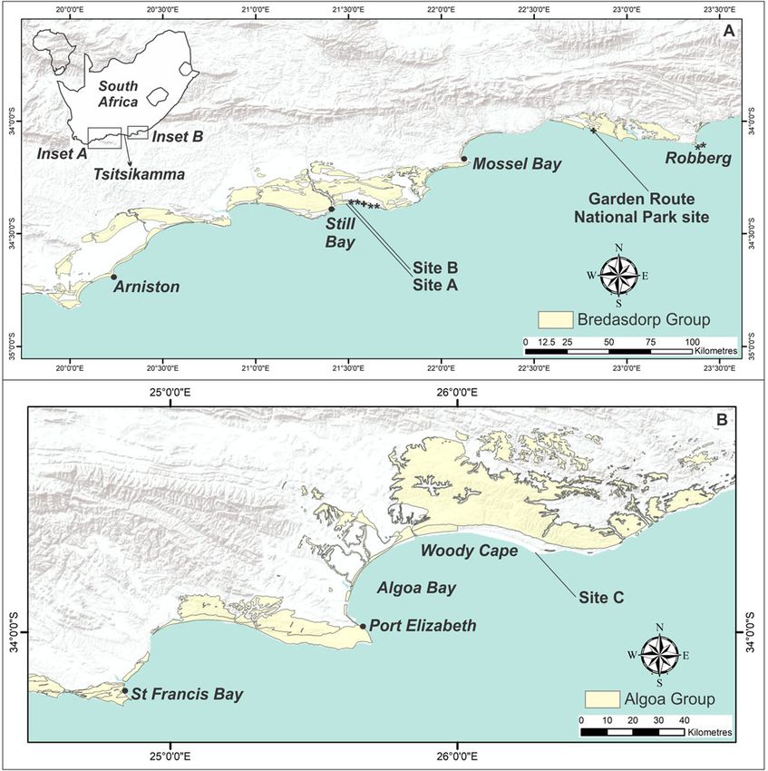
170                                                                                                                                              M. G. Lockley et al.

        Figure 1. (color online) Map of the Cape south coast and Cape southeast coast, showing the extent of deposits of the Bredasdorp Group (A)
        and Algoa Group (B). Golden mole burrow sites are indicated by *. Sites A, B, and C indicate sand swimming sites. Equivocal sites are indi-
        cated by +.

        are amenable to recognition and interpretation today in the                              introduced predation and transport biases that affect whether
        form of ammoglyphs (Helm et al., 2019b).                                                 we view such data as representative of once-living communi-
           The track record has also corroborated the body fossil                                ties. In contrast, the track record provides evidence of the
        record with respect to extinct members of the regional Pleis-                            presence of living animals moving on ancient dune and
        tocene megafauna. Examples include documentation of                                      beach surfaces. However, some bias is present in the case
        tracks and trackways of the long-horned buffalo or giant buf-                            of tracks, as larger, heavier animals registered larger, often
        falo (Syncerus antiquus), and the giant Cape zebra (Equus                                deeper tracks, which may be easier to recognize and interpret
        capensis) (Helm et al., 2018c, 2020a).                                                   today. Larger tracks may also be less susceptible to rapid ero-
           Furthermore, we know the information gleaned from tradi-                              sion once exhumed and exposed.
        tional body fossil sites is often biased, as the primary accumu-                            These surfaces of unconsolidated, but locally firm, sand
        lators of these assemblages (people, carnivores, etc.)                                   may have been attractive to vertebrate trackmakers as easily

Downloaded from https://www.cambridge.org/core. IP address: 46.4.80.155, on 30 May 2021 at 06:03:12, subject to the Cambridge Core terms of use, available at
https://www.cambridge.org/core/terms. https://doi.org/10.1017/qua.2020.97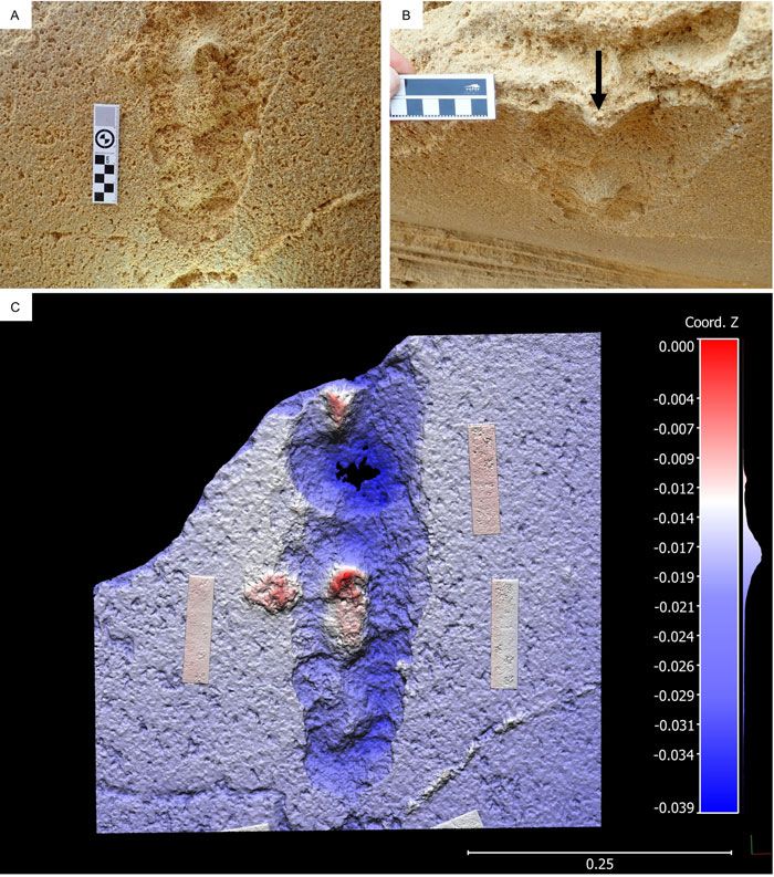
Pleistocene golden mole and sand‐swimming trace fossils                                                                                             171

            accessible, unrestricted travel corridors. For other Pleistocene                         for the formation of coastal dune cordons. However, on Rob-
            animals, the presence of sand or soil may have been a require-                           berg, Carr et al. (2019) documented the first currently non-
            ment for their existence, including fossorial groups like the                            submerged examples of onshore accumulation (MIS 3), that
            golden moles (order Afrotheria, family Chrysochloridae).                                 are not associated with a sea-level high-stand. Deposits pre-
            Examples would include burrow traces or trails: within this                              served on the continental shelf were associated with both
            family some species only require soft sandy or loamy sub-                                transgressive and regressive sea-level events (Cawthra et al.,
            strates in which to burrow, whereas, for example, Grant’s                                2018).
            golden mole (Eremitalpa granti) has requirements that are                                   The aeolianites mostly comprise fine-to medium-grained
            dune-specific.                                                                            sand with a high carbonate content derived from marine
               We report here on such traces, both those that appear sim-                            shell fragments. Dune deposits become cemented as a result
            ilar to traces made by members of the extant regional fauna                              of the downward percolation of rainwater in the meteoric dia-
            (and are thus not unexpected), and those which appear to                                 genetic zone, which mobilizes the carbonate shell compo-
            have been made by sand-swimmers, which resemble the                                      nent; carbonates are re-deposited as interstitial cement
            tracks made by representatives of the genus Eremitalpa,                                  within the sandstone matrix (Flügel, 2004). An explanation
            which, today, is known from the west coast region but not                                of the plentiful occurrence of vertebrate tracks and traces in
            the south coast region. Recognition of Eremitalpa traces typ-                            coastal southern African aeolianites has been proposed by
            ifies many of the aforementioned occurrences: they were not                               Roberts and Cole (2003), through a combination of: cohesive
            anticipated as a result of the body fossil record, they probably                         moist sand, which provides an effective moulding agent;
            represent one or more extinct species, and they allow for                                high sedimentation rates, which promote swift track burial;
            palaeo-environmental inferences. Furthermore, they are                                   rapid lithification via partial solution and re-precipitation of
            unique in the global ichnological record. The purpose of                                 bioclasts; and shoreline erosion, which re-exposes the track-
            this article is to document the evidence from these golden                               bearing surfaces.
            mole trace fossil sites, to consider their implications, and—                               Pleistocene sedimentary facies are dominated by large-
            where appropriate—to describe, erect, and interpret new                                  scale, steeply dipping, planar cross-stratification formed by
            ichnotaxa.                                                                               foreset progradation of dunes (Roberts et al., 2008). Alternat-
                                                                                                     ing with such facies are low-angled laminated facies that
                                                                                                     represent interdune areas (Hunter, 1977; Fryberger et al.,
            GEOLOGICAL CONTEXT
                                                                                                     1979). A few intermittent palaeosols also occur and may con-
            Structurally, the ∼800-km-long Cape south coast region com-                              tain evidence of burrow traces. Shallow marine environments
            prises three key elements: the mountains of the Cape Fold                                are represented by cemented shoreface and foreshore hori-
            Belt; a seaward-dipping relatively low-relief coastal platform                           zons, along with fine-grained surfaces representing lagoonal
            bordered by the Indian Ocean; and a broad, planar continental                            environments. Vertebrate tracks and traces are found in aeo-
            shelf forming the Agulhas Bank, which extends from Cape                                  lianites and deposits representing interdune, foreshore, and
            Agulhas to the northeastern boundary of Algoa Bay. Pleisto-                              lagoonal environments.
            cene sea-level oscillations, related to rapid climate changes,                              Cenozoic deposits occur extensively along the coastline of
            led to the repeated exposure and inundation of the vast                                  southern Africa (Roberts et al., 2006). On the Cape south
            Palaeo-Agulhas Plain. This region is characterised by its                                coast, they are classified as the Bredasdorp Group. Within
            wide continental shelf (∼270 km wide south of Cape Agul-                                 this group, the Pleistocene aeolianites comprise the Waenhui-
            has) with a shelf break shoaling from 200 m off Cape Agulhas                             skrans Formation (Malan, 1989), and the Pleistocene marine
            to ∼140 m south of Port Elizabeth (Martin and Flemming,                                  deposits comprise the Klein Brak Formation (Malan, 1991).
            1986). The coastline of the Cape south coast is dominated                                On the Cape southeast coast, Cenozoic deposits are classified
            by deposits of the Palaeozoic Cape Supergroup, with struc-                               as the Algoa Group. Within this group, the Pleistocene aeo-
            tural embayments infilled by Mesozoic and Cenozoic depos-                                 lianites form the Nahoon Formation (Le Roux, 1989), and
            its of the Uitenhage Group, Bredasdorp Group and Algoa                                   the marine deposits comprise the Salnova Formation (Le
            Group. Northeast of Algoa Bay, the geological substrate of                               Roux, 1991). The boundary between the Bredasdorp Group
            the coast, as well as the character of the continental shelf,                            and Algoa Group is Tsitsikamma. In the east, sea level is
            changes markedly (e.g., Dingle et al., 1983).                                            also the main driver of deposition in the Algoa Group, and
               Pleistocene calcarenite rocks on the present-day coastal                              recent dating studies carried out on the strata (e.g., Jacobs
            plain are the fringing remnants of a dominance of comparable                             and Roberts, 2009) indicate that the depositional patterns
            deposits on the adjacent shelf (Cawthra et al., 2015). Aeolian-                          and trends mirror those of the Bredasdorp Group. The Waen-
            ites of the Bredasdorp Group that are currently evident above                            huiskrans Formation and Nahoon Formation have been corre-
            sea level along the modern coast represent phases of dune                                lated, as have the Klein Brak Formation and Salnova
            construction that appear mostly to be associated with regres-                            Formation (Le Roux, 1990; Roberts et al., 2006). Distin-
            sive phases of sea level, following the sea-level high stands of                         guishing between aeolian and marine sediments of these
            Marine Isotope Stage (MIS) 11 and MIS 5e (Carr et al., 2010;                             respective formations is not always straightforward: this is a
            Bateman et al., 2011; Roberts et al., 2012; Cawthra et al.,                              reflection of transition zones that often exist between the
            2018). Such circumstances provided a source of sand suitable                             upper ends of beach deposits and the lower reaches of dune

Downloaded from https://www.cambridge.org/core. IP address: 46.4.80.155, on 30 May 2021 at 06:03:12, subject to the Cambridge Core terms of use, available at
https://www.cambridge.org/core/terms. https://doi.org/10.1017/qua.2020.97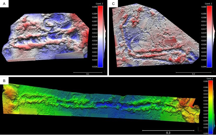
172                                                                                                                                              M. G. Lockley et al.

        deposits, where sea-level fluctuations and sediment rework-                                  Photographs were taken, including images for photogram-
        ing may further complicate interpretation.                                               metry (Falkingham, 2012; Matthews, 2016; Falkingham
           Trace fossil sites may occur in situ, either in epirelief on                          et al., 2018). Photogrammetry 3D models were generated
        exposed surfaces, in hyporelief under overhangs, or in cross                             with Agisoft Metashape Professional (v. 1.0.4) using an
        section in cliffs. Cliff collapse events are common, and                                 Olympus TG-5 camera (focal length 4.5 mm; resolution
        numerous loose blocks and slabs, some with track-bearing                                 4000 × 3000; pixel size 1.56 × 1.56 um). The final images
        surfaces, come to rest at the base of cliffs and above present                           were rendered using CloudCompare (v.2.10-beta).
        sea level. In such cases it is important to understand the strati-
        graphic orientation of the blocks in order to interpret the trace                        RESULTS
        fossils. Ichnologists distinguish between epifaunal surface
        traces (tracks and trackways), deeper infaunal traces (e.g.,                             Six sites from the Cape south coast that suggest golden mole
        burrows), and shallow sub-surface trails.                                                burrows are described and listed from west to east as i) to vi).
           The ichnological terminology used for tetrapod burrows is                             Three of these, iii), v) and vi), have previously been reported.
        somewhat different from the terminology used for trackways,                              Description then follows of three other sites (Sites A, B and
        and beyond the scope of this paper to review in detail. Gen-                             C), from west to east, that suggest sand-swimming golden
        erally, small- and medium-sized tetrapods can create both                                moles as tracemakers. This is followed by description of
        burrows and trackways, whereas larger tetrapods generally                                two equivocal sites, one of which could not be closely
        leave only tracks. The term ‘trackway’, indicating a discontin-                          approached, and another which presented identification
        uous sequence of footprints, is generally not appropriate for                            challenges.
        the extended horizontal burrows described here. Rather,
        ‘trail’ with its connotation of a surface pathway (as in a                               Burrow traces
        ‘game trail’) can be used, as in a ‘surface trail’ made by a sin-                           i) A site identified on a loose block east of Still Bay
        gle trail maker. However, the general term ‘burrow’ is also                                    exhibited filled burrow traces up to 80 cm in length
        widely used as a descriptor. In either case the distinction
                                                                                                       and up to 7 cm in diameter (Fig. 2A).
        between a horizonal infaunal burrow or an epifaunal trail is
        important from both a morphological and behavioral view-                                   ii) Two km east of i), burrow traces up to 75 cm in
        point, notwithstanding a given species’ ability to make                                        length and up to 6 cm in diameter, without infill,
        both. Features within the trail, made by the trail-maker’s var-                                were identified on a loose block (Fig. 2B).
        ious limbs, may legitimately be referred to as tracks, or by the                          iii) One possible golden mole burrow site was previ-
        more generic term ‘trace’. Some of the sand-swimming fea-                                      ously described from further east of Still Bay
        tures we describe are ichnologically intermediate between                                      (Helm et al., 2019c), where a massive fallen
        epifaunal trackways and the deeper infaunal burrows made                                       block contained multiple bedding planes, on
        by other members of the golden mole family. In this article,                                   which elephant, artiodactyl, and avian trackways
        we do not use the term ‘trackway’ in describing such features,                                 were noted, in addition to small invertebrate traces
        but favor the use of the term ‘trail’, as the least-ambiguous                                  and probable golden mole burrow traces without
        terminology.                                                                                   infill. Direct measurement of length and diameter
                                                                                                       was not feasible, but a diameter of up to 10 cm
        METHODS                                                                                        was estimated. An image from this site is repro-
        Global Positioning System readings were obtained for trace                                     duced here as Figure 2C.
        fossil sites, using a handheld device. For safely accessible                              iv) A site 3 km further east from iii) exhibited a long,
        sites, measurements were taken of length, width, and depth                                     sinuous burrow trace (length not measurable,
        (in centimetres) of the trace fossils. Strike and dip measure-                                 diameter 7 cm), without infill, on the underside
        ments were recorded for in situ sites. Full-size tracings were                                 of a large fallen block (Fig. 2D).
        made where appropriate, using clear acetate film: these have                                v) Two golden mole burrow sites were described
        been reposited in the University of Colorado Museum                                            from Robberg (Helm et al., 2019d). The first site
        (UCM) archive in the series T1890–T1898 (for October                                           contained filled burrow traces up to 300 cm in
        2019). Samples were taken for optically stimulated lumines-                                    length, and up to 7 cm in diameter, within sedi-
        cence (OSL) dating at sites A and B, and stratigraphic corre-                                  ments that have been demonstrated to be in the
        lation to known dated sites was applied, indicating a MIS 5
                                                                                                       range of 35–42 ka (Carr et al., 2019). An image
        age. Locality data was reposited with the African Centre for
        Coastal Palaeoscience, to be made available to researchers                                     from this site is reproduced here as Figure 2E.
        upon request.                                                                             vi) The second Robberg site contained filled burrow
           We determined the orientation of surfaces, both where                                       traces up to 140 cm in length, and up to 7 cm in
        obvious for in situ sites, and where cross-sectional stratigra-                                diameter. These burrows occur as epifaunal (sur-
        phy determined the orientation of loose blocks. This approach                                  face) features and infaunal (cross sectional) fea-
        helped identify other tracks and traces in cross section.                                      tures, and included a chamber, in sediments

Downloaded from https://www.cambridge.org/core. IP address: 46.4.80.155, on 30 May 2021 at 06:03:12, subject to the Cambridge Core terms of use, available at
https://www.cambridge.org/core/terms. https://doi.org/10.1017/qua.2020.97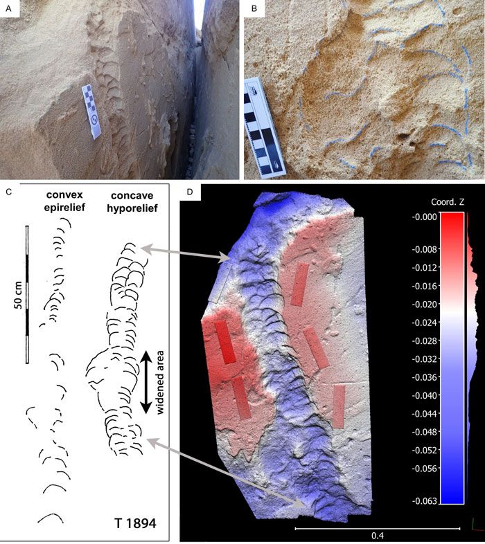
Pleistocene golden mole and sand‐swimming trace fossils 173
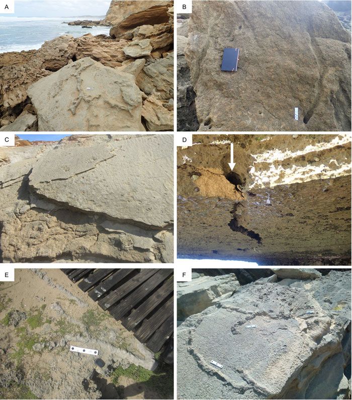
Figure 2. (color online) (A) Filled burrow traces east of Still Bay; scale bar = 10 cm between outer black circles. (B) Burrow traces without
infill east of Still Bay; scale bar = 10 cm between outer black circles. (C) Inaccessible burrow traces without infill east of Still Bay. (D) Long,
sinuous burrow trace on the underside of a large fallen block east of Still Bay. Arrow indicates infaunal portion. (E) Filled burrow traces at
Robberg; scale bar = 25 cm between outer black circles. (F) Filled burrow traces at Robberg; scale bars = 10 cm between outer black circles.
dated in the range of 56–67 ka (Carr et al., 2019). at various stratigraphic levels in cross section on the western
An image from this site is reproduced here as and eastern sides (Figs. 3C and 3D) clearly indicate the south-
Figure 2F. ern as the epirelief surface on which the tracks were originally
registered, and the northern the hyporelief infill surface.
At the western ends of these two surfaces, we examined a
Sand-swimming trails trail that resembled that of a sand-swimming golden mole. It
extended for at least 130 cm in a curved fashion (Fig. 4).
Site A
Trackway width was 8–10 cm. At the lower end a wider por-
East of Still Bay, a large (4 × 4 × 4 m) split block, dislodged tion (maximum 18 cm in diameter) extended over a distance
from the cliffs above, is at rest on the beach, with its bedding of 17 cm (Fig. 4B). Preserved detail of this trackway on the
planes vertically orientated in a shore-parallel, east-west northern surface was far superior to that on the southern sur-
direction (Figs. 3A and 3B). The distance between the face. However, as discussed below, due to it being the ‘mold-
exposed part and counterpart epifaunal impressions and cor- ing’ of a convex-up feature it appears in concave hyporelief,
responding natural casts varied from 2 cm at the bottom to unlike the natural casts (in convex hyporelief) of tracks on the
∼50 cm at the top. The confined space prevented the tracks same surface. Tracings (T 1894) were made (Fig. 4C) and
from being seen to good advantage, and we could only photogrammetry was applied (Fig. 4D) forming the basis
describe them as large (∼20 × ∼16 cm), with substantial for the holotype for Natatorichnus subarenosa ichnogen. et
displacement rims. Elephant, hippopotamus or rhinoceros ichnosp. nov., as detailed below (Ichnotaxonomy). A sample
represent the most likely trackmakers. Tetrapod tracks seen was taken for OSL dating.
Downloaded from https://www.cambridge.org/core. IP address: 46.4.80.155, on 30 May 2021 at 06:03:12, subject to the Cambridge Core terms of use, available at
https://www.cambridge.org/core/terms. https://doi.org/10.1017/qua.2020.97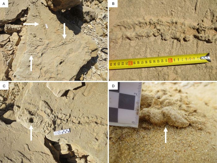
174                                                                                                                                              M. G. Lockley et al.

        Figure 3. (color online) (A) Site A, viewed from the west. (B) Site A, viewed from the east. (C) Bedding planes at Site A, viewed from the west,
        showing deformation from tetrapod tracks, which allowed the ‘way up’ to be determined; white scale bar = 10 cm. (D) Bedding planes at Site
        A, viewed from the east, showing deformation from tetrapod tracks, which allowed the ‘way up’ to be determined.

        Site B                                                                                   Site C yields the holotype for Natatorichnus sulcatus ichno-
                                                                                                 gen. et ichnosp. nov. (Fig. 6B). Photogrammetry was applied
        Two km east of Site A, preserved on the underside of a low
                                                                                                 to the Site C surfaces (Figs. 7A–C). The host rocks consist of
        ceiling (Fig. 5A), we identified a 37-cm-long hyporelief
                                                                                                 well-sorted fine-to-medium sand, lithified by post-deposition
        trail varying in width between 8 and 12 cm, with localized
                                                                                                 cementation of calcium carbonate.
        infilling of a prominent median sulcus (furrow) (Fig. 5B).
        Photogrammetry was applied to this trackway (Fig. 5C). A
        sample was taken for OSL dating. Two nearby loose slabs                                  Equivocal sites
        were inferred to have originated from the same horizon;
        both exhibited tracks of the extinct giant Cape zebra (Equus                             Two km east of Site B, hyporelief trails/burrows were
        capensis) representing a galloping gait pattern. As detailed                             observed, on the underside of a protruding rock ledge ∼10
        below (Ichnotaxonomy), Site B yields a paratype for Natator-                             m above the cliff base (Figs. 8A and 8B). This was a fragile,
        ichnus sulcatus ichnogen. et ichnosp. nov.                                               unstable area, with a significant risk of cliff collapse, prevent-
                                                                                                 ing attempts to get close to the trails or to measure them. How-
                                                                                                 ever, we observed evidence of a median feature, probably the
        Site C
                                                                                                 infill of a deep median sulcus in the original trackway. We
        Site C lies in the Woody Cape region of the Addo Elephant                                regard the site as relevant to the topic of golden mole traces,
        National Park, more than 450 km east of sites A and B. A clus-                           access problems notwithstanding. Roberts et al. (2008)
        ter of epirelief trails with distinctive morphology was observed                         reported dates in the range of (140 ka ± 8.3 ka – 91 ka ± 4.6
        on three adjacent aeolianite slabs in the Nahoon Formation,                              ka) for sediments dated from a site located ∼100 m to the east.
        respectively 2.0 m and 3.6 m apart (Fig. 6A–D). The largest                                 More than 100 km east of Sites A and B, in a coastal portion
        slab measured more than 150 × 120 cm, but the orientation                                of the Garden Route National Park, a loose slab lay exposed on
        of these slabs could not be determined, as they appeared to                              a dune surface above the high-tide mark. The slab measured
        have separated from more-elevated in situ surfaces with iden-                            60 × 60 cm, and was ∼20 cm thick. While the ichnological evi-
        tical stratigraphy, less than 5 m above mean sea level. The                              dence was described as “difficult to interpret”, tracks on this
        trails are preserved predominantly in convex epirelief, except                           surface were interpreted in Lockley et al. (2019) as possibly
        for the median sulcus, which is in concave epirelief. These                              having been made by a hatchling turtle. An alternating paddle
        trails exhibit localized widenings or terminations beside                                trace gait was noted, suggestive of a loggerhead turtle (Caretta
        rounded cavities. The longest trail is more than 100 cm in                               caretta) trackmaker. The longest segment of trackway mea-
        length with width between 5 and 7 cm. As detailed below,                                 sured 25 cm in length, with a diameter of 9 cm.

Downloaded from https://www.cambridge.org/core. IP address: 46.4.80.155, on 30 May 2021 at 06:03:12, subject to the Cambridge Core terms of use, available at
https://www.cambridge.org/core/terms. https://doi.org/10.1017/qua.2020.97
Pleistocene golden mole and sand‐swimming trace fossils                                                                                             175

            Figure 4. (color online) (A) and (B) Hyporelief surface at Site A, showing holotype of Natatorichnus subarenosa ichnogen. et ichnosp. nov.
            Bulges of trail architecture are lightly outlined in chalk in B, which shows the area of widening; scale bars = 10 cm. (C) Tracing T 1894 of Site
            A; epirelief on the left, hyporelief on the right. (D) Photogrammetry color mesh of hyporelief surface at Site A, using 59 images. Photos were
            taken an average of 28.4 cm from the surface. The reprojection error is 0.41 pix. Vertical and horizontal scales are in metres.

               We re-examined and re-analyzed this loose specimen                                    traces and burrows of various depths. From a functional-
            (Fig. 9), and could not determine the stratigraphic orientation                          behavioral, morphological, and ichnotaxonomic viewpoint,
            with confidence. We therefore cannot definitively say                                      the surface trackways, trails and burrows of golden moles,
            whether the trackmaker/trailmaker was a hatchling logger-                                like those of other burrowing tetrapods, are quite different,
            head turtle or a sand-swimming golden mole. The plausibility                             though they may be followed one into another. Although
            of a turtle trackmaker in this general locality is borne out by                          there are no ancient examples of surface or epifaunal track-
            our identifying, since the publication of Lockley et al. (2019),                         ways attributed to golden moles, their present-day infaunal
            a further hatchling turtle tracksite on a loose slab 1 km west of                        burrows and trails are known, as described here, and there
            this site. In this case, reliable indicators were present that indi-                     is a previously-illustrated example from an Early- to Middle
            cated which was the ‘right way up’, and the turtle origin of the                         Tertiary site in Namibia (Ward, 1988; Fig. 10). Modern bur-
            trackway could be confidently asserted.                                                   rows can be quite variable, depending on two important fac-
                                                                                                     tors: i) the depth of the burrow, and ii) the sediment
                                                                                                     composition. Here we focus on burrows and trails in sandy
            ICHNOTAXONOMY
                                                                                                     facies in which our examples of sand-swimming behaviour
                                                                                                     are registered. We further demonstrate that burrow and trail
            Preamble
                                                                                                     morphologies vary in recognizable ways depending on the
            Modern golden mole traces, although not described in detail,                             depth of the burrowing or sand swimming. However, it is out-
            and known mainly from documentary and other videos and                                   side the scope of this paper to analyze golden mole burrows
            photographs, are variable and include surface footprints and                             made in other substrates, such as vegetated soils.

Downloaded from https://www.cambridge.org/core. IP address: 46.4.80.155, on 30 May 2021 at 06:03:12, subject to the Cambridge Core terms of use, available at
https://www.cambridge.org/core/terms. https://doi.org/10.1017/qua.2020.97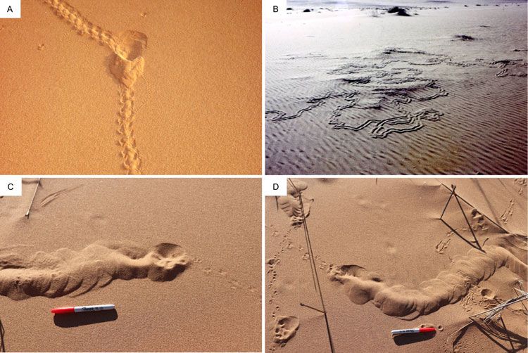
176                                                                                                                                              M. G. Lockley et al.

        Figure 5. (color online) (A) Hyporelief surface at Site B showing paratype for Natatorichnus sulcatus ichnogen. et ichnosp. nov.; scale bar =
        10 cm; the apparent semicircular ending of the trail may represent emergence at a higher stratigraphic level. (B) Angled view at Site B, showing
        the median sulcus in hyporelief, indicated with an arrow; scale bar in cm. (C) Photogrammetry color mesh of hyporelief surface at Site B, using
        37 images. Photos were taken an average of 36.9 cm from the surface. The reprojection error is 0.47 pix. Vertical and horizontal scales are in
        metres.

           For the reasons outlined above and below, we erect the new                               Derivation of name: natator, from the Latin meaning
        ichnogenus Natatorichnus ichnogen. nov., meaning ‘swim-                                  ‘swimmer’ and ichnos meaning ‘trace’.
        mer trace’, with the connotation that swimming traces can                                   Diagnosis: Flattened, sand filled, sub-horizontal, linear to
        only be made and preserved in a non-liquid medium where                                  meandering, transmitted trail or shallow burrow trace, up to
        there is organism-substrate contact. Under Natatorichnus,                                ∼10 cm wide, with local width irregularities. Traces are gen-
        we erect the new ichnospecies N. subarenosa ichnosp. nov.                                erally upwardly and anteriorly convex into a low roof or
        for near-surface trail morphologies that exhibit a raised                                ridge, or with ridge or roof mid-line collapsed into a central
        roof, and N. sulcatus ichnosp. nov. for near-surface trails                              furrow or sulcus. They are transversely divided into short
        that characteristically show collapse of the roof as they are                            spreite expressed as low amplitude, en échelon, anteriorly
        being made. A diagnosis is given for the ichnogenus, and                                 convex bulges, which tend to be arranged sequentially in
        descriptions and a differential diagnosis for both ichnospe-                             alternating left-right patterns.
        cies, which are represented by holotypes and a paratype.                                    Natatorichnus subarenosa ichnosp. nov. (Fig. 4)
                                                                                                    Type locality and horizon: The same as for ichnogenus, the
                                                                                                 Pleistocene Waenhuiskrans Formation.
        Formal ichnotaxonomy
                                                                                                    Derivation of ichnospecies name: sub from the Latin mean-
        Natatorichnus ichnogen. nov.                                                             ing ‘under’ and arenosa meaning ‘sand.’
          Holotype: Specimen shown from Site A in Figure 4.                                         Description: Sand filled, sub-horizontal, sub-linear flat-
          Type locality: Site A, east of Still Bay.                                              tened, convex-up transmitted trail trace, ∼10 cm wide.
          Type horizon: The Pleistocene Waenhuiskrans Formation.                                 Trace upwardly and anteriorly divided into short en échelon

Downloaded from https://www.cambridge.org/core. IP address: 46.4.80.155, on 30 May 2021 at 06:03:12, subject to the Cambridge Core terms of use, available at
https://www.cambridge.org/core/terms. https://doi.org/10.1017/qua.2020.97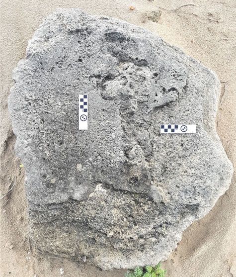
Pleistocene golden mole and sand‐swimming trace fossils                                                                                             177

            Figure 6. (color online) (A) Trails in epirelief at Site C, arrow indicates the holotype of Natatorichnus sulcatus ichnogen. et ichnosp. nov.;
            scale bar = 10 cm. (B) Part of holotype of Natatorichnus sulcatus ichnogen. et ichnosp. nov., preserved in epirelief with characteristic median
            furrow or sulcus; compare with Figure 7B. (C) Epifaunal trail beside a cavity (indicated with an arrow) at Site C; scale bar = 10 cm. (D) Mag-
            nified view of epifaunal traces at Site C, indicated by arrow, showing en échelon bulges; scale bar in cm and mm.

            anteriorly-convex transverse spreite, numbering ∼50 per                                  might be labeled as an infaunal, Fodichnia trace, in contrast
            meter. Anteriorly-convex spreite show consistently alternat-                             to its epifaunal, surface walking or Repichnia trace. As
            ing left and right traces.                                                               these traces may pass one into another and other forms may
               Natatorichnus sulcatus ichnosp. nov. (Figs. 5, 6 and 7)                               be present, such as resting traces (Cubichnia) or dwelling
               Holotype: Site C (Figs. 6B and 7B).                                                   traces (Domichnia), such traces are complex. While all poten-
               Paratype: Site B (Fig. 5).                                                            tial variants may be useful indicators of the animal’s behav-
               Type locality: Site C, Woody Cape, Addo Elephant                                      ioural repertoire, some are outside the scope of this paper.
            National Park.                                                                              Differences between N. subarenosa and N. sulcatus (both
               Type horizon: The Pleistocene Nahoon Formation.                                       considered Fodichnia) can be attributed to the stability of the
               Derivation of ichnospecies name: sulcatus from the Latin                              roof under which the trailmaker passed just below the surface.
            meaning ‘furrow’.`                                                                       In short, the roof of the former did not collapse whereas in the
               Differential diagnosis: N. sulcatus differs from N. subare-                           latter case it did. Videos of extant sand-swimming golden
            nosa in showing a prominent central furrow or sulcus that rep-                           moles making such traces show that these are primary ichno-
            resents collapse of the trail roof as the trailmaker progressed just                     logical features: i.e., the roof of N. subarenosa does not col-
            below the surface of the sand. The N. sulcatus holotype is nar-                          lapse as it is made, but in the case of N. sulcatus the roof
            rower than that of N. subarenosa, whereas the Site B N. sulcatus                         collapse occurs continuously as soon as the posterior portion
            paratype is of similar width as the N. subarenosa holotype.                              of the tracemaker’s body no longer holds up the thin sand
               Description: Sand filled, sub-horizontal, sub-linear flat-                              roof it created by passing just below the surface of the
            tened, convex up transmitted trail trace, ∼5.0–7.0 cm wide.                              sand (andBeyond, 2017, https://www.youtube.com/watch?
            Trace upwardly and anteriorly divided into short en échelon                              v=8dP2LIUGekg). Thus, in the latter, the collapse is not a
            anteriorly convex transverse spreite, numbering ∼70 per                                  secondary, post-registration feature. Differences in the cohe-
            meter. Central furrow feature is present, as noted above.                                sion of the surface layers of the sand, and minor variations in
            The degree of collapse of the trail roof, and hence the width                            the depth of the sub-surface activity, may play a role in deter-
            of the collapsed section, may vary, as seen in Figure 7B.                                mining whether or not the roof collapses. Given that depth of
                                                                                                     sub-surface activity and cohesion of the surface sand can
                                                                                                     vary over short distances, both factors may come into play. In
            General ichnotaxonomic remarks
                                                                                                     either case (depth or sediment cohesion), the tracemaker pushes
            As noted above, Natatorichnus can be distinguished as a                                  a bow wave of sand forward, upward and outward, and with
            mole sub-surface trail, distinct from the surface walking                                each intermittent forward movement, registers a similar but sep-
            trail. Given that it appears to be a feeding or foraging trail it                        arate trace. Thus, the separate segments reflect incremental stop

Downloaded from https://www.cambridge.org/core. IP address: 46.4.80.155, on 30 May 2021 at 06:03:12, subject to the Cambridge Core terms of use, available at
https://www.cambridge.org/core/terms. https://doi.org/10.1017/qua.2020.97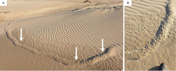
178                                                                                                                                              M. G. Lockley et al.

        Figure 7. (A) Photogrammetry color mesh of short trail on western epirelief surface at Site C, using 7 images. Photos were taken an average of
        26.2 cm from the surface. The reprojection error is 0.6 pix. Vertical and horizontal scales are in metres. (B) Photogrammetry color mesh of
        holotype of Natatorichnus sulcatus ichnogen. et ichnosp. nov, (compare with Figure 6B) on western epirelief surface at Site C, using 33
        images. Photos were taken an average of 16.5 cm from the surface. The reprojection error is 0.54 pix. Vertical and horizontal scales are in
        metres. Note that in the topographically lowest area of the present surface (blue end of spectrum) the burrow is more completely collapsed:
        see text for details. (C) Photogrammetry color mesh of long trail on western epirelief surface at Site C, using 34 images. Photos were taken an
        average of 25.1 cm from the surface. The reprojection error is 0.47 pix. Vertical and horizontal scales are in metres. (For interpretation of the
        references to color in this figure legend, the reader is referred to the web version of this article.)

        and go movements, as seen in some videos (BBC, 2016, https://                            one can observe that the anterior bulges generally register in
        www.youtube.com/watch?v=jlL1yFEaK4U). In short, the sand                                 an alternating left-right sequence. This again indicates that
        wave flows and freezes alternately with each forward thrust of                            the tracemaker did not ‘plow’ forward without a component
        the tracemaker, and we can therefore estimate how many                                   of side to side motion of its head, which again is characteristic
        motions the animal made to progress for a given distance. How-                           of the motion seen on video. Also in the case of the N. subar-
        ever, rate of progression cannot be estimated due to the                                 enosa holotype (Site A in Fig. 4), a widened area is seen which
        unknown duration of pauses. In the case of N. subarenosa                                 indicates deviation from a more linear motion.

        Figure 8. (color online) (A) View up cliffs east of Site B. Arrow indicates trails under an overhanging ledge. (B) Magnified view, showing trails
        in hyporelief.

Downloaded from https://www.cambridge.org/core. IP address: 46.4.80.155, on 30 May 2021 at 06:03:12, subject to the Cambridge Core terms of use, available at
https://www.cambridge.org/core/terms. https://doi.org/10.1017/qua.2020.97
Pleistocene golden mole and sand‐swimming trace fossils 179
trails and deeper burrows described here. As shown in Fig-
ure 11 and Figure 12, when a sand-swimming golden mole
is travelling just below the surface it pushes up the sand sur-
face as it moves forward. This motion is expressed in a series
of anteriorly and upwardly convex sand waves where each
new bow wave emerges from just below the formerly created
wave, to leave an elongated ridge with transverse en échelon
spreite.
While the upper surface of the burrow is being pushed up
‘dorsally’, the mole is arching its body upwards, and may use
its digging limbs to scoop out the sand on the ventral, under-
side of its body. This also might produce a series of spreite-
like traces in the sediment associated with the burrow floor.
However, in loose sand the burrow does not remain open as
the animal passes, and the sand fills in behind it: i.e., as Mar-
tin (2013) says, near the surface moles do not actively fill their
burrows. We might also surmise that the ventral floor of the
burrow would be smoothed out by the forward movement
of the animal, leaving little or no trace of the lateral scoops
of the digging forelimbs or the webbed hind limbs, even
before the sand passing over the burrower’s dorsal side falls
in to bury the already smoothed-out burrow floor. Thus, it
is only when the characteristic surface expression of the
Figure 9. (color online) The surface of the Garden Route National mole burrows or trails are preserved that one will be able to
Park site; scale bars = 10 cm. identify their diagnostic characteristics. For example, the
trace illustrated by Ward (1988; Fig. 10) shows that the suc-
cessive upwardly slanted and anteriorly-convex sand waves,
Martin (2013, pp. 416–417) states that “in terms of behav-
bulges or crescents arose en échelon from underneath each
ior mole burrows can be interpreted on the basis of depth.
previously created trace, with a spacing of about 6 waves
Shallower tunnels, easily seen as prominent 10–15 cm
per 10 cm (∼60/m). This is manifestly the expression of the
wide linear to meandering ridges on the surface, are the
disturbed surface–atmosphere interface. In this sense, what
results of hunting for food. . . . In contrast, deeper more
we have been calling a trail is actually not the organism sedi-
permanent burrow systems 15–50 cm below the surface . . .
ment interface but an upward transmission of the forces gen-
are used for dwelling.” Martin (2013, p. 418) continues:
erated by the activity. In strict ichnological terms this is a
“Near the surface moles do not actively back fill their bur-
transmitted trace, but a transmitted over-trace, not a transmit-
rows, but instead push excavated sediment upward to the
ted under-trace, and not what has been called an over track or
surface.” These observations, although not made in reference
over-trace, where a true trace has subsequently been covered
to sand-swimmers, or golden moles, are pertinent to distin-
or filled (Marty et al., 2009).
guishing between the architecture (morphology) of shallower
In order for this surface to be preserved it must have been
buried without destroying its characteristic morphology. The
mechanisms that facilitated such preservation are not easily
determined without direct evidence of the characteristics of
sediment above and below the interface on which the dorsal
surface of the burrow was expressed. As noted above, this
could be more easily facilitated if the surface developed
some measure of cohesion or crust as might result from wet-
ting of the sand surface by dew, sea mist, or spray. The surface
would also have to resist deflation or erosion scouring by the
energy associated with the next depositional event, perhaps
deposition of fine wind-blown sand as suggested by Lockley
et al. (2019) as a mechanism to bury the trackways of hatch-
ling turtles. Whatever the mechanisms, the examples
described here, as well as the one illustrated by Ward
(1988; Fig. 10) are proof that some attribute of sediment
Figure 10. (color online) Trace fossil from Namibia, attributed to cohesion within the trail rendered it more resistant to weath-
Eremitalpa sp. by Ward (1988). Reproduced with permission from ering, or susceptible to differential weathering, than the sur-
John Ward. rounding sediment.
Downloaded from https://www.cambridge.org/core. IP address: 46.4.80.155, on 30 May 2021 at 06:03:12, subject to the Cambridge Core terms of use, available at
https://www.cambridge.org/core/terms. https://doi.org/10.1017/qua.2020.97180 M. G. Lockley et al.
Figure 11. (color online) (A) Surface trackway of E. granti, interrupted by a ‘dip’ causing a widened area, with a change in direction and a short
sand-swimming section (reproduced with permission from Chris & Mathilde Stuart, www.StuartOnNature.com). (B) E. granti sand-
swimming traces with central sulcus, showing area-concentrated searching (reproduced with permission from Laura Fielden). (C) and (D)
show E. granti sand-swimming trails with transition to and from surface trackways; scale bars = ∼14 cm (reproduced with permission from
the Gobabeb Research & Training Centre).
Figure 12. (color online) Schematic representation of locomotion above and below the substrate of sand-swimming golden mole. Note the
difference between epifaunal tracks when walking and infaunal, shallow collapsed trails (N. sulcatus morphotype) and raised-roofed trails
(N. subarenosa morphotype).
DISCUSSION (2019), in reporting on micromammal remains from archaeo-
logical and palaeontological sites on the Cape south coast,
Golden mole fossils spanning a time interval from MIS 9 to MIS 1, noted only
indeterminate Chrysochloridae specimens, which had not
Avery (2019) provided a comprehensive list of land mammal been identified to the genus or species level.
fossils from southern Africa, from the Eocene to the Holo- No body fossils of Eremitalpa are known from the south
cene. Representatives of the Chrysochloridae are documented coast, and the first record of this monospecific genus is of
from all the epochs of this time interval. Matthews et al. the type specimen of the extant species E. granti from Garies
Downloaded from https://www.cambridge.org/core. IP address: 46.4.80.155, on 30 May 2021 at 06:03:12, subject to the Cambridge Core terms of use, available at
https://www.cambridge.org/core/terms. https://doi.org/10.1017/qua.2020.97Pleistocene golden mole and sand‐swimming trace fossils 181
in South Africa’s Northern Cape Province (Broom, 1907). represent small Pleistocene mammals that created burrows
However, Asher and Avery (2010), in describing early Plio- in size (diameter) ranges of 4.5–12.0 cm, but mostly in the
cene golden mole fossils from Langebaanweg, near the 6.0–8.0 cm range. Ponomarenko (2019, p. 80) concluded
west coast of South Africa, reported two new species. One, that “the most important tools for burrow diagnostics are
which they named Chrysochloris arenosa, exhibited mor- architecture followed by diameter and sculpture.”
phology in the distal humerus which resembled that seen in As shown below, it is comparatively easy to demonstrate
Eremitalpa. Asher and Avery (2010) suggested that this the difference between horizontal to sub-horizontal (bedding-
might represent adaptation to a habitat similar to that of the parallel) trails made by sand-swimming golden moles, and
sand-swimming E. granti. those made by small mammals digging at various angles in
Prior to the inception of the Cape south coast ichnology pro- soils and alluvium with different sedimentological character-
ject, the only report that we are aware of that described proba- istics (texture and consolidation). Small mammals create dis-
ble golden mole trace fossils is from Ward (1988, pp. 153– tinctive infaunal ichnological signatures, such as burrow wall
155), who, in reporting on Early- to Middle Tertiary sediments scratch marks, that can be distinguished from one another and
from Namibia, noted that “back-filled, burrow-like traces cut- from other infaunal traces and sedimentary features.
ting cross eolian stratification in the Tsondab Sandstone For-
mation resemble trackways left by the golden mole,
Extant golden moles and genus Eremitalpa
Eremitalpa sp., that today is endemic to the Namib Desert”.
In Figure 10 we reproduce the photograph from Ward (1988) Golden moles (order Afrotheria, family Chrysochloridae) are
and note that this trace fossil has similar features to those of endemic to sub-Saharan Africa (Stuart and Stuart, 2014).
the N. subarenosa holotype, although it is of lesser width. Bronner and Jenkins (2005) identified and listed 21 species,
However, the N. sulcatus trails from Site C are of similar of which 18 occur in southern Africa. Many species have
width (∼5–6 cm) to the specimen described by Ward (1988). such extremely restricted distribution ranges that they are
known from only a single locality or single specimen (Stuart
and Stuart, 2014), and 10 of the 21 species are classified as
The six burrow trace sites
threatened. Thus, as a family, golden moles display high
The six non-sand-swimming burrow trace sites (i-vi) are sug- rates of endemism. The relatively widespread ‘species’
gestive of golden mole burrows, but are there plausible alter- Amblysomus hottentotus may in fact represent a species com-
natives to such features? Stuart and Stuart (2019) review plex, containing distinct cryptic species that may be vulnera-
extant southern African burrow makers, which in addition ble (Mynhardt et al., 2015).
to golden moles include mole rats (Bathyergus suillus), mon- Eremitalpa, known as the desert-dwelling mole or Namib
goose species (Herpestidae), suricates (Suricata suricatta), mole (Perrin and Fielden, 1999), is a monospecific genus,
ground squirrels (Xerus inauris), warthogs (Phacochoerus with two subspecies (Meester et al., 1986). E. granti granti
africanus), aardvark (Orycteropus afer) and porcupines (Hys- inhabits the west coast of South Africa, from near St. Helena
trix africaeaustralis). Of these, only the golden moles pro- Bay in the south to north of Port Nolloth in the north, while
duce sub-surface tunnels that resemble the trails at the six E. granti namibensis is restricted to the Namib Desert in
sites we describe. Namibia, south of the Kuiseb River (Perrin and Fielden,
Rhizoliths and root casts also need to be considered. While 1999). The Orange River was a geographical barrier that led
these structures are typically encountered in palaeosols or to the isolation of the two sub-species (Maree and Bronner,
heavily bioturbated areas, and are typically vertically oriented 2016). Both sub-species are restricted to sandy dune habitats.
and cut across bedding planes, they may also occur on aeo- They may represent cryptic species (Maree and Bronner, 2016).
lianite surfaces and follow such bedding planes. Roots, like Multiple adaptations to an existence in sand and locomo-
some burrows, may exhibit branching. However, they usually tion through sand have been described (Perrin and Fielden,
taper over their length, and often visibly alter the appearance 1999). Although totally blind, E. granti has developed a
of the surrounding rock (Klappa, 1980). We did not observe search pattern that is effective in encountering patches of
such changes at any of the sites we describe, and so confi- high prey availability. It is the smallest of the golden moles,
dently infer these to be golden mole burrow traces. and has short, medially-located limbs with long, broad,
Ponomarenko (2019) reported various Pleistocene burrows ventrally-hollowed foreclaws for burrowing in loose sand
from Russia (the Borissiak Paleontological Institute reference (Smithers, 1983). Termites form the favoured prey (Fielden
collection), which he attributed to small mammals including et al., 1990), and the enormous epitympanic recess and
moles (family Talpidae) and various rodents, including blind large malleus are particularly sensitive to vibrations (Nolte,
mole rats (Spalacidae), squirrels (Sciuridae) and rodents in 1968) and are used in locating its prey (Fielden, 1989).
the vole and lemming family (Cricetidae). These burrows,
which occur in cross sections in palaeosols and alluvium,
Sand-swimming species and trail morphology
and not in dune deposits, vary considerably in morphology,
with as many as five morphotypes identified based on size, The Namib mole (E. granti) is a surface forager, and hunts
shape, and orientation (vertical, inclined and surficial). prey at night. Unlike other golden moles, Eremitalpa does
Despite the differences in facies, the Russian traces all not inhabit or create a system of burrows (Fielden et al.,
Downloaded from https://www.cambridge.org/core. IP address: 46.4.80.155, on 30 May 2021 at 06:03:12, subject to the Cambridge Core terms of use, available at
https://www.cambridge.org/core/terms. https://doi.org/10.1017/qua.2020.97182 M. G. Lockley et al.
1992). Fielden (1989) and Perrin and Fielden (1999) Convergent adaptation to similar dune conditions is possi-
described the distinctive form of locomotion employed by ble, and sand-swimming locomotion by other fossorial mam-
E. granti known as sand-swimming as shallow sub-surface mal species (or even reptiles) cannot be fully excluded.
movement (i.e., at a shallower level than any of the sub- However, with the exception of the brief transition phases
surface tunnels and burrows of other golden mole species). described above, there is no current evidence for this form
Locomotion involves “lateral rather than dorso-ventricular of locomotion in any genus other than Eremitalpa.
articulation with the forelimbs providing most propulsion” It is necessary to differentiate sand-swimming trail mor-
(Perrin and Fielden, 1999, p. 3). This form of locomotion phology from other trails found in the same deposits. For
alternates with surface locomotion (Fig. 11A) (Fielden example, Lockley et al. (2019) reported the first-known fossil
et al., 1992). E. granti sand-swimming traces are typically hatchling turtle tracks close to the present study areas.
found in three situations: a) for 1–2 m at the beginning or Potentially, sand-swimming traces could be confused with
end of the surface tracks where the mole had either entered hatchling turtle tracks. For example, the paddle impressions
or emerged from its daytime refuge, b) around the bases of made in concave epirelief by hatchling turtles resemble the
plants, and c) in areas of open sand where a termite concen- sequence of crescentic bulge traces of sand-swimmers if
tration had been encountered (Fielden, 1989). they are preserved in convex hyporelief on a natural cast sur-
E. granti sand-swimming traces may extend for 20 to 50 m face. However, once a turtle has left the sub-surface nest its
(Fielden, 1989). Surface trackways may be interrupted by trackway is purely epifaunal, whereas sand-swimmer trails
dips which create areas of widening, sometimes associated are characteristically infaunal or semi-infaunal. From a pres-
with directional changes (Fig. 11A). Dips typically represent ervational viewpoint, hatchling turtle trackways may repre-
the act of stopping to listen for prey, especially termites (Fiel- sent progression over sediment of different moisture content
den, 1989). The area of widening observed at Site A (Fig. 4), from that traversed by sand swimmers. Additionally, ichnol-
cannot reliably be attributed to this kind of dip, as it is not ogists must consider how the epifaunal trails are subsequently
associated with a surface trackway. buried, possibly by wind-blown sand with different textural
During sand-swimming activity, the animal’s locomotion properties from the trackway-bearing surface (Lockley
creates raised areas (convex epirelief) with well-preserved, 2019). As noted above, the convex epirelief of N. subarenosa
anteriorly-convex margins. Depending on substrate consis- trails could also be buried by wind-blown sediment-carrying
tency, the midline portion of the trail may collapse behind winds insufficiently powerful to deflate the traces.
the trackmaker, leaving a linear sulcus (concave epirelief, Furthermore, in hatchling turtle trackways, the plastron
Fig. 11B), hence our use of the term sulcatus to describe may be elevated off the sand surface, leaving no median
the similar ichnospecies morphotype. Alternatively, where trace, or it may make contact with the surface. In the former
not collapsed, and preserved in convex epirelief (Figs. 11C case, the median area is more raised relative to the tracks
and 11D), the N. subarenosa morphotype is preserved. If formed by the paddle impressions. The sand-swimming
the sand substrate is not cohesive, the entire trail may collapse trail N. sulcatus is differently divided into a median low epi-
and be preserved in concave epirelief (Fig. 11B). Figure 12 relief sulcus, and two lateral, higher epirelief portions. N. sul-
offers a schematic representation of the variation recognized catus morphotypes must be viewed the ‘right way up’ so as
between epifaunal walking trails, entry points into the sub- not to be confused with a hatchling turtle trackways, and
strate, collapsed trails (N. sulcatus morhotype), trails with a vice versa. The equivocal site in Garden Route National
raised roof (N. subarenosa morphotype), and exit points. Park (Fig. 9) represents a case where such confusion could
We have noted Cape south coast non-Eremitalpa golden arise. The habitat for such turtle tracks, on relatively level
mole trail transitions from surface travel to typical sub-surface areas above the high tide mark, is used also by golden
burrowing, where a short segment (less than 20 cm) resem- moles. Martin (2013) described long American mole (Scalo-
bles sand-swimming traces. In such cases, caution should pus aquaticus) burrows extending shoreward as far as the
be exercised before attributing such transitional traces to high-water mark, and we frequently encounter golden mole
sand-swimming by Eremitalpa. burrows just above the high-water mark in our neoichnolog-
Golden mole species that usually create deeper burrows ical studies on the Cape south coast.
may briefly burrow slightly closer to the surface and create When tracks are preserved in situ, rather than on loose
predominantly transverse cracks (Fig. 13). These are distinct blocks and slabs, determining the ‘way up’ of burrows and
from the randomly orientated crack features found on the trails is easy. Larger track-bearing surfaces may allow distin-
domed surface of such burrow traces, and likely represent var- guishing patterns to emerge–for example, parallel trackways
iation in burrowing behaviour or sediment consistency. heading in a seaward direction suggest hatchling turtles as
The trails at Sites A and B exhibit a diameter range from 8– trackmakers (Lockley et al., 2019). A symmetrical (rather
12 cm, wider than expected from a sand-swimming track- than alternating) gait pattern suggests a leatherback turtle
maker like E. granti. A large Eremitalpa species, now extinct, (Dermatochelys) trackmaker (Lockley et al., 2019). Addition-
may have inhabited the Pleistocene dune fields of what is now ally, the regularity of the pattern is greater than in mole traces,
the Cape south coast. However, the trails at Site C have a as might be expected for a trackmaker that could move its
diameter of 5–7 cm, similar to the E. granti trails and the fos- limbs freely, not hampered by plowing through the medium
sil trail from Namibia described by Ward (1988). of a viscous substrate. The sand-swimming trails described
Downloaded from https://www.cambridge.org/core. IP address: 46.4.80.155, on 30 May 2021 at 06:03:12, subject to the Cambridge Core terms of use, available at
https://www.cambridge.org/core/terms. https://doi.org/10.1017/qua.2020.97You can also read