Port Pegasus/ Pikihatiti Salmon Farms - Natural Character, Landscape and Visual Amenity Effects Assessment Prepared for Environment Southland & ...
←
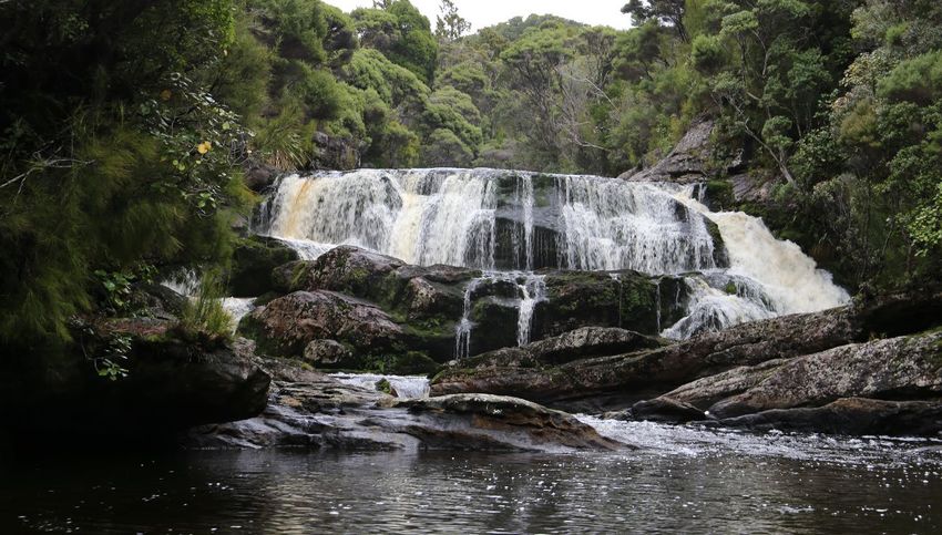
→
Page content transcription
If your browser does not render page correctly, please read the page content below
V4

                                                                 _FINAL

Port Pegasus/ Pikihatiti Salmon
                          Farms
Natural Character, Landscape and Visual Amenity Effects Assessment
  Prepared for Environment Southland & Ministry for Primary Industries

                                                     11 October 2017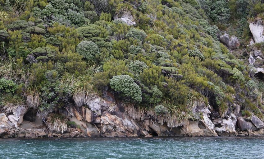
Document Quality Assurance
 Bibliographic reference for citation:
 Boffa Miskell Limited 2017. Port Pegasus/ Pikihatiti Salmon Farms: Natural Character,
 Landscape and Visual Amenity Effects Assessment. Report prepared by Boffa Miskell
 Limited for Environment Southland & Ministry for Primary Industries.

 Prepared by:                         James Bentley
                                      Principal Landscape Architect
                                      Boffa Miskell Limited

 Reviewed by:                         Yvonne Pfluger
                                      Principal Landscape Architect
                                      Boffa Miskell Limited

 Status: Final                        Revision / version: [E]                              Issue date: 11 October 2017

 Use and Reliance
 This report has been prepared by Boffa Miskell Limited on the specific instructions of our Client. It is solely for our Client’s use for
 the purpose for which it is intended in accordance with the agreed scope of work. Boffa Miskell does not accept any liability or
 responsibility in relation to the use of this report contrary to the above, or to any person other than the Client. Any use or reliance
 by a third party is at that party's own risk. Where information has been supplied by the Client or obtained from other external
 sources, it has been assumed that it is accurate, without independent verification, unless otherwise indicated. No liability or
 responsibility is accepted by Boffa Miskell Limited for any errors or omissions to the extent that they arise from inaccurate
 information provided by the Client or any external source.

Template revision: 20150331 0000

File ref: C16160A_01e_Natural_Character_Landscape_Assessment_Clean_20171011.docx

Cover photograph: [Port Pegasus coastal interface, © James Bentley, 2017]
CONTENTS

Executive Summary                                                                         1

1.0    Introduction                                                                       3

       Purpose and Scope of report                                                        3
       Investigation and Potential Options                                                4
       Methodology                                                                        6
       Data Sources                                                                       6
       Site Visits and Photographic Records                                               7

2.0    Description of Existing Environment                                                7

       Site Location                                                                      7
       Stewart Island                                                                     8
       Port Pegasus/ Pikihatiti                                                           9

3.0    The Investigation                                                                 17

4.0    Statutory Planning Context                                                        19

       Resource Management Act legislation                                               20
       Other Statutes and related documents                                              24
       Summary of Statutory Documents                                                    25

5.0    Natural Character Values                                                          25

       Definition                                                                        25
       Methodology                                                                       26
       Existing condition and mapped extents: Port Pegasus wide                          27
       Local Natural Character Condition                                                 30

6.0    Landscape Values                                                                  35

       Approach                                                                          35
       Methodology                                                                       36
       Mapped extents and degree of naturalness                                          37
       Landscape Values                                                                  38

7.0    Visual Amenity Values                                                             41

8.0    Effects Assessment                                                                42

       Overall approach to assessing effects                                             42
       Natural Character of the Coastal Environment Effects                              42

U:\2016\C16160A_JBe_Port Pegasus Salmon
Farms\Documents\C16160A_01e_Natural_Character_Landscape_Assessment_Clean_20171011.docx
Landscape and Natural Feature Effects                               46
      Visual Amenity Effects                                              47
      Summary of Actual and Potential Effects                             51

9.0   Recommended Measures to Reduce Significance of Effects              51

10.0 Conclusion                                                           52

Appendices
Appendix 1: Landscape & Visual Methodology

Appendix 2: Explanation of farm site selection and production scenarios

Appendix 3: Different Scenarios
Executive Summary

The Ministry for Primary Industries (MPI) along with The Southland Regional Development
Strategy (SoRDS) have identified opportunities for fin fish farming within the Southland Region.
Investigations into this have identified the North Arm of Port Pegasus, Stewart Island/ Rakiura
as being an area where fin fish farming could occur. Boffa Miskell was commissioned by MPI
and Environment Southland to undertake a Natural Character, Landscape and Visual Amenity
Assessment for investigations for various scenarios of fin fish farming, assisted by ecological
data provided by Cawthron, the Department of Conservation and Environment Southland.

The North Arm of Port Pegasus is located in a part of the remote and isolated east coast of
southern Stewart Island. Stewart Island is renowned for its wild and remote landscape values,
containing very high levels of naturalness and very high heritage values. Human modification is
limited to discrete parts of the island.

Being remote and isolated from much of mainland New Zealand has resulted in the island
holding a relatively diverse number of terrestrial habitats, ranging from indigenous forests and
shrublands to wetlands, sand/ dune communities and alpine ecosystems. There is a wide
diversity of indigenous species on and around Stewart Island, including rare and endemic
lizards and invertebrates, and birds such as the Stewart Island brown kiwi/tokoeka.

Within the seascape or the marine environment, Stewart Island/ Rakiura is located within the
Southern Ocean, at one of the world’s great oceanic boundaries – the subtropical convergence,
where the prevailing westerly wind and currents from the Tasman Sea moderate the
temperatures protecting the island from the cooler subantartic waters further south. An array of
marine wildlife lives within the sheltered and more exposed waters off Stewart Island/Rakiura
including fur seals, sea lions and yellow-eyed penguins. The marine environment of Stewart
Island is one of the largest areas of highly natural marine habitats in New Zealand. It is the
southern extreme of many mainland species and communities.

In terms of cultural and heritage aspects, Stewart Island is extremely important to Maori where
numerous middens, burial areas and waka-landing sites have been identified that support this.
European adventurers have also explored this island, setting up sealing and whaling related
activities.

Based on the above, Stewart Island, and the North Arm of Port Pegasus, holds special
landscape values and has been assessed as being an Outstanding Natural Landscape, under
Section 6(b) of the RMA and under Policy 15 of the NZCPS.

Furthermore, due to North Arm’s limited modifications holding almost intact indigenous marine
and terrestrial habitats, it is concluded that this area retains Outstanding levels of Natural
Character under Section 6(a) of the RMA and under Policy 13 of the NZCPS.

Allied to this, the Island, including North Arm, also holds very high levels of amenity values.

The introduction of structures and modifications will affect many of the values that make this
part of Stewart Island outstanding. For landscape, it is considered that the insertion of salmon
farming would adversely affect the landscape and natural qualities of North Arm of Port
Pegasus and of Big Ship Passage to such a degree that the area, or part of the area, could no
longer be considered outstanding, irrespective of a chosen scenario. Part of North Arm and Big

Boffa Miskell Ltd | Port Pegasus/ Pikihatiti Salmon Farms | Natural Character, Landscape and Visual Amenity Effects Assessment | 11 October 2017   1
Ship Passage would then be aligned with the non-outstanding rating of Big Glory Bay and parts
               of Half Moon Bay, where a relatively high level of development has occurred. As a result, it is
               considered that the scenarios assessed here would be contrary to the RMA and the direction of
               the objectives and policies of Policy 15 (1) of the New Zealand Coastal Policy Statement, as
               well as the regional and district plans. The effects would be significant within the North Arm of
               Port Pegasus.

               For natural character, and with the natural elements, patterns and processes evident within
               North Arm being amongst the highest in the country, these enclosed waters will be adversely
               affected by the development scenarios, both at a broad scale and at a more local scale. The
               farm scenario would interrupt and be discordant with the natural elements, patterns and
               processes that are currently present and would affect the scale and natural cohesiveness of the
               area, directly impacting on experiential aspects. It is concluded that all scenarios will have very
               high adverse natural character effects both at the broad and more local scales. The scenarios
               would also be inconsistent with the RMA and the direction of Policy 13 (1) (a) of the New
               Zealand Coastal Policy Statement.

               With visual amenity values, irrespective of which scenario is chosen, the grow out farms in Big
               Ship Passage would be very visible for up to 2km and when travelling south from North Arm,
               may appear partly against the horizon, amplifying their visual presence. They would affect the
               visual cohesion of the area and with their central presence within Big Ship Passage, their visual
               presence would be amplified.

               The location of any semi-industrial style activity within an area retaining outstanding landscape
               and natural character values, with no or very little existing modification, will create significant
               adverse effects on those values that underpin the landscape and natural character overlays.
               Irrespective of where the farms are located and which scenario is selected, the effects cannot
               be avoided, remedied or mitigated. The key visual effects relate principally to the insertion of
               human elements within a wholly natural environment.

               The significance of landscape, natural character and visual amenity effects is considered to be
               in the highest category on the scale of effects outlined in the methodology. The scenarios
               constitute a substantial change to an area holding some of the most sensitive and valued
               landscape, natural character and visual amenity values in the country, leading to highly adverse
               effects, irrespective of which scenario is chosen.

2              Boffa Miskell Ltd | Port Pegasus/ Pikihatiti Salmon Farms | Natural Character, Landscape and Visual Amenity Effects Assessment | 11
October 2017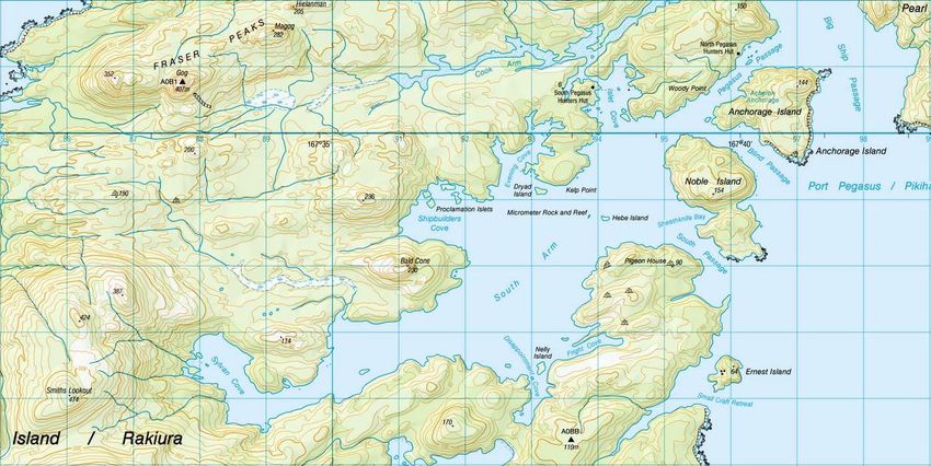
1.0 Introduction

1.1        Boffa Miskell Limited (BML) was commissioned by Environment Southland (ES) and the
           Ministry for Primary Industries (MPI) to undertake a Natural Character, Landscape and
           Visual Amenity Assessment for investigations into finfish (salmon) farming to be located
           within the waters of Port Pegasus (North Arm), Stewart Island. Currently there is no
           aquaculture development or permanent structures within the waters of Port Pegasus.
1.2        BML have worked alongside the Cawthron Institute (Cawthron), MPI, ES, the
           Department of Conservation (DOC) and Southland Regional Development Strategy
           (SoRDS) staff to understand the investigation requirements and to assist in developing
           options for the design and placement of the farms. The clients are aware of the very
           high landscape and natural character sensitivities of Port Pegasus from initial
           discussions and this report assesses the effects of several scenarios against these high
           values and characteristics. BML is also aware that under the current statutory
           documents, the placement of salmon farms within Port Pegasus is a prohibited activity.
           This report and other specialist assessments articulate the effects of the scenarios,
           while overall decisions on the appropriateness of such an activity will be made by the
           relevant consent authorities and/or other decision makers.
1.3        Within this report, ‘the Site’ refers to the location of all of the salmon farming
           infrastructure scenarios within the two areas in the North Arm of Port Pegasus (see
           Image 1). All the scenarios are indicative, designed to test the feasibility and effects of
           certain production levels in the two general areas. In the scenarios, all infrastructure is
           located within the water-space and not on the land. Additional potential land-based
           infrastructure for staff accommodation and feed storage has not been taken into
           account within this report.
1.4        A graphic attachment accompanies this report with a number of maps and
           photographs, taken by the author and peer-reviewer during on-site investigations
           undertaken on 22 May 2017. The site visit involved investigations by boat in the North
           and South Arm of Port Pegasus.
1.5        BML has a long and involved history with aquaculture related activities throughout New
           Zealand, being involved with landscape, visual and natural character assessments for
           many complex applications for both applicants and councils. Based on this, BML
           personnel is considered to have the skills and experience to undertake this assessment.

Purpose and Scope of report
1.6        This landscape and visual assessment considers all aspects of the scenarios
           throughout construction and operation, including the effects of introducing structures
           into the Port Pegasus North Arm landscape. The report also considers the various
           scenarios considered, including location, layout and design of the structures. As
           mentioned above, the scenarios are indicative and potential land-based infrastructure
           for staff accommodation and feed storage has not been taken into account within this
           report.

Boffa Miskell Ltd | Port Pegasus/ Pikihatiti Salmon Farms | Natural Character, Landscape and Visual Amenity Effects Assessment | 11 October 2017   3
Investigation and Potential Options
               1.7        MPI is investigating the potential for establishing salmon farming operations within the
                          waters of North Arm in Port Pegasus. Alongside a series of studies undertaken by
                          Cawthron, MPI and Boffa Miskell, broad areas were identified based on benthic habitat
                          value and suitability, and a series of farm scenarios developed. The hatched area on
                          the plan is essentially governed by biological data observed by Cawthron, and
                          represents areas where some of the most ecologically significant benthic species and
                          habitats are not present. This area is outlined below on Image 1.

                                                Image 1: Identified areas of where salmon farming activities could be considered

               1.8        Through a series of telephone-based workshops, where ecological and landscape
                          considerations were discussed, these areas were refined and a series of scenarios
                          developed based on different tonnages of fish and different polar cage sizes. Tonnage
                          relates to a series of considerations, including water flow, water depth and location.
               1.9        These initial scenarios were presented and developed as part of the first draft of this
                          report. Following a review of the initial reports, a review of the scenarios was
                          undertaken to maximise their efficiency following receipt of further technical information
                          from Cawthron. Based on this, a refreshed set of scenarios was developed, centred
                          around one smolt growing area in North Arm and four mid-channel farms in Big Ship
                          Passage. These refined scenarios were centred on fixed 160m circumference pens (as
                          opposed to pens of varying sizes) and developed around the quantum of feed and
                          number of pens required to safely manage fin-fish farming in these locations.
               1.10       As a result, this assessment assesses four indicative infrastructure scenarios, to test
                          different configurations of feed quantity and pen numbers. These are listed as
                          Scenarios 1a, 2a, 3a and 4a. A further set of scenarios have also been developed,
                          based on scenarios (a), where the same amount of infrastructure is required however
                          their quantum of feed has been increased. This second set of scenarios (listed as
                          Scenarios 1b, 2b, 3b and 4b) is based on increasing the density of fish and
                          consequently the quantity of feed.

4              Boffa Miskell Ltd | Port Pegasus/ Pikihatiti Salmon Farms | Natural Character, Landscape and Visual Amenity Effects Assessment | 11
October 2017
1.11       The following scenarios were established by the client and considered under this
           assessment (Table 1):
           Table 1: Production number and farm sizes 1

    Scenario      Input parameters                                          Farming area                      Grow-out           Smolt
                                                           f1           f2            f3           f4         totals             totals
    1a            Feed per pen (tonne)                     131          131           150          225                           64
                  Number pens                              16           16            16           16         64                 8
                  Total feed (tonne)                       2100         2100          2400         3600       10200              510
                  Total production (FCE 1.7)               1235         1235          1412         2118       6000
    2a            Feed per pen (tonne)                     131          131           150          225                           63
                  Number pens                              8            10            14           14         46                 6
                  Total feed (tonne)                       1050         1312.5        2100         3150       7613               381
                  Total production (FCE 1.7)               618          772           1235         1853       4478
    3a            Feed per pen (tonne)                     131          131           150          225                           79
                  Number pens                              6            8             12           12         38                 4
                  Total feed (tonne)                       787.5        1050          1800         2700       6338               317
                  Total production (FCE 1.7)               463          618           1059         1588       3728
    4a            Feed per pen (tonne)                     131          131           150          225                           60
                  Number pens                              4            6             8            10         28                 4
                  Total feed (tonne)                       525          787.5         1200         2250       4763               238
                  Total production (FCE 1.7)               309          463           706          1324       2801
    1b            Feed per pen (tonne)                     175          175           200          300                           85
                  Number pens                              16           16            16           16         64                 8
                  Total feed (tonne)                       2800         2800          3200         4800       13600              680
                  Total production (FCE 1.7)               1647         1647          1882         2824       8000
    2b            Feed per pen (tonne)                     175          175           200          300                           85
                  Number pens                              8            10            14           14         46                 6
                  Total feed (tonne)                       1400         1750          2800         4200       10150              508
                  Total production (FCE 1.7)               824          1029          1647         2471       5971
    3b            Feed per pen (tonne)                     175          175           200          300                           102
                  Number pens                              6            8             12           12         38                 4
                  Total feed (tonne)                       1050         1400          2400         3600       8450               407
                  Total production (FCE 1.7)               618          824           1412         2118       4971
    4b            Feed per pen (tonne)                     175          175           200          300                           79
                  Number pens                              4            6             8            10         28                 4
                  Total feed (tonne)                       700          1050          1600         3000       6350               317
                  Total production (FCE 1.7)               412          618           941          1765       3735

1
 Cawthron (October 2017) Report No. 3047 Benthic Habitat Assessment: North Arm Port Pegasus/ Pikihatiti, Table
A9.1 Farm scenarios and parameters, page 92

Boffa Miskell Ltd | Port Pegasus/ Pikihatiti Salmon Farms | Natural Character, Landscape and Visual Amenity Effects Assessment | 11 October 2017   5
1.12       Each scenario includes five barges associated with each farm (grow out pens and
                          smolt). The scenarios are further described within Section 3 of this report illustrated in
                          Appendix 3.

               Methodology
               1.13       While there is no universally accepted method for natural character, landscape and
                          visual assessments, best practice combines both technical and evaluative components
                          and is tailored to suit the nature of the project and its context including the framework of
                          the governing legislation. For the purposes of this assessment, the Resource
                          Management Act (RMA) is the principal Act under which the assessment has been
                          made.
               1.14       Within Appendix 1 of this report is a more detailed methodology which is summarised.
                          below:

                                •    Description of Existing Landscape. The existing landscape is described in terms
                                     of the current landscape’s physical, perceptual and associated factors. An
                                     evaluation was also undertaken to determine the landscape’s significance when
                                     assessed against sections 6(a) and 6(b) of the RMA as well as the objectives of
                                     the Conservation Act, and provisions in the Southland Regional Policy
                                     Statement and Stewart Island/Rakiura Conservation Management Strategy
                                     insofar as they apply to landscape.

                                •    Relevant Statutory Provisions. Consideration has been given to statutory
                                     provisions relevant to natural character, landscape and visual matters. These
                                     are identified in Section 4 of this report.

                                •    Assessment of Natural Character, Landscape and Visual Amenity Values. A
                                     stock take of existing documents and the values identified. Furthermore, a
                                     review of other scientific reports relevant to this investigation is undertaken,
                                     notably for natural character reasons.

                                •    Assessment of Natural Character and Landscape Effects. Assessment of the
                                     scenarios against the existing landscape character and values identified above
                                     in the context of RMA Sections 6(a) and (b), the New Zealand Coastal Policy
                                     Statement, the Conservation Management Strategy and the Conservation Act
                                     1987. Note this report does not consider effects on significant ecological values
                                     in terms of Section 6(c) of the RMA.

                                •    An assessment of the visual amenity effects as a result of the changes to
                                     prominent or important views, aesthetic coherence and to public accessibility.

                                •    An assessment of cumulative effects is included, since multiple farms are
                                     included in each scenario.

                                •    Recommendations: Where appropriate, measures are recommended in order to
                                     avoid or mitigate the level of potential natural character, landscape and visual
                                     amenity effects, where possible.

               Data Sources
               1.15       Key data sources used in the preparation of this assessment include:

6              Boffa Miskell Ltd | Port Pegasus/ Pikihatiti Salmon Farms | Natural Character, Landscape and Visual Amenity Effects Assessment | 11
October 2017
• The relevant statutory planning documents (refer to Section 4 of this report)
• Relevant expert reports including:
- Benthic Habitat Assessment: North Arm, Port Pegasus/ Pikihatiti prepared by
Cawthron (Report No. 3047) and dated October 2017.
- Pelagic Biophysical Assessment: Port Pegasus/ Pikihatiti prepared by
Cawthron (Report No. 3076) and dated October 2017Review of potential NZ
sea lion interactions with aquaculture at Port Pegasus / Pikihatiti, prepared by
NIWA for the Department of Conservation (Report No: 2017264WN), August
2017
• Google Earth
• NZ 1:50,000 Topographical Maps
• Observations and photographs recorded during field work
Site Visits and Photographic Records
1.16 A site visit by boat was undertaken by James Bentley and Yvonne Pfluger on Monday
22 May 2017. The weather was overcast. The sea conditions off the eastern coast of
Stewart Island were reasonably calm, with a swell recorded of between 2.0 to 3.0
metres. Within Port Pegasus, the swell was significantly less, to virtually very calm
conditions. There was little wind. The boat sailed from Oban down the eastern coastline
of Stewart Island to Port Pegasus. Once there, the main vessel anchored and a smaller
boat was used to explore the northern part of North Arm, noticeably Belltopper Falls and
the location of the former freezing works. The vessel then travelled down the north-
western part of North Arm, visiting Albion Inlet, Bens Bay and Bulling Bay before exiting
North Arm through Pegasus Passage towards South Arm. In South Arm, Shipbuilders
Cove was visited followed by the western end of South Arm near Bald Cone. The vessel
then travelled to Disappointment Bay and Fright Cove, before exiting through South
Passage and back to Oban.
1.17 A series of photographs were taken during the boat trip and a selection of these are
included within the accompanying Graphic Supplement (Site Photographs 1 to 20).
2.0 Description of Existing Environment
Site Location
2.1 The Site is located with North Arm of Port Pegasus, a remote and isolated part of the
east coast of southern Stewart Island (see Figure 1 Location Plan in graphic
attachment).
Boffa Miskell Ltd | Port Pegasus/ Pikihatiti Salmon Farms | Natural Character, Landscape and Visual Amenity Effects Assessment | 11 October 2017 7Stewart Island
2.2 Being the third largest island of New Zealand, Stewart Island/ Rakiura is located 30
kilometres south of Bluff, across the Foveaux Strait within the Southern Ocean. Holding
a land area of approximately 1,680km², the island and its many smaller islands are
renowned for their wild and remote setting, very high levels of naturalness and very high
heritage values. With approximately 85% of the island contained in National Park
status, much of the original vegetation has remained intact (see Figures 3 and 4).
Human modification is limited to discrete parts of the island, such as Halfmoon Bay
where the principal small settlement of Oban is located, and Horseshoe Bay.
Throughout the remainder of the island, modification is limited (e.g. recreation
infrastructure such as tracks and huts).
2.3 Having geological links to the granite geology of Fiordland, Stewart Island/ Rakiura
contains a range of impressive landforms, from the granite and schist ridges of the
southern inland ranges to the broad inland freshwater basin and bogs in the north (see
Figure 2). Being a highly indented island, Stewart Island/ Rakiura contains two large
and several smaller inlets. Patterson Inlet on the east coast and Port Pegasus on the
southern coast are the most significant in terms of sizes and complexity and contain
quieter, more settled waters, whilst the remaining coastline is rugged and rocky. Broad
sandy beaches are also evident, with the most significant beach being at Mason Bay on
the west coast.
2.4 In terms of vegetation, Stewart Island/ Rakiura retains a relatively diverse number of
habitats, ranging from indigenous forests and shrublands to wetlands, sand/ dune
communities and alpine ecosystems (see Figures 2 and 5). Podocarp-hardwood forest,
comprising principally rimu, kamahi and southern rata dominate the majority of the
island, with an extensive sub-canopy of broadleaves, such as Griselinia littoralis,
lancewood and tree ferns. Some browsing is experienced throughout the island by deer
and possums. The ground and shrub tiers of the forest are often sparse with very few
young hardwood trees.
2.5 There is a wide diversity of indigenous species on and around Stewart Island, including
rare and endemic lizards and invertebrates, and birds such as the Stewart Island brown
kiwi/tokoeka. Other rare/ threatened birds include three penguin species (yellow-eyed
penguin, Fiordland crested penguin and little blue penguin) as well as other birds,
including the weka, southern NZ dotterel, shags, Stewart Island robin and Stewart
Island fernbird. The critically endangered kakapo exists on Codfish Island. Stewart
Island/ Rakiura also has nationally significant populations of sooty shearwater, red-
crowned parakeet and South Island saddlebacks 2.
2.6 In terms of the seascape or the marine environment, Stewart Island/ Rakiura is located
within the Southern Ocean, at one of the world’s great oceanic boundaries – the
subtropical convergence, where the prevailing westerly wind and currents from the
Tasman Sea moderate the temperatures protecting the island from the cooler
subantartic waters further south. Foveaux Strait separates these islands from the South
Island, and in good weather extensive seascape vistas over the Strait are obtained of
both tracts of land. An array of marine wildlife lives within the sheltered and more
exposed waters off Stewart Island/Rakiura including fur seals, sea lions and yellow-
eyed penguins. The marine environment of Stewart Island is one of the largest areas of
2
Conservation Management Strategy Stewart Island, page 26
8 Boffa Miskell Ltd | Port Pegasus/ Pikihatiti Salmon Farms | Natural Character, Landscape and Visual Amenity Effects Assessment | 11
October 2017highly natural marine habitats in New Zealand. It is the southern extreme of many
mainland species and communities.
2.7 With Stewart Island/ Rakiura sharing two names, one English and the other Maori, both
are officially recognised and are often used interchangeably. For Maori, Raikiura is
translated as ‘The Island of Glowing Skies’, a reference to the long sunsets and the
nocturnal sky-displays of the Southern Lights or Aurora Australis. Rakiura is also an
abbreviation of Te Rakiura a Te Rakitamau, which refers to the blushing
embarrassment of a young man, Te Rakitamau, when he was refused the hand in
marriage of both daughters of a chief of the island. Suffice to say that the island is very
important to Maori, especially as Rakiura is also referred to as Te Puka a te Waka a
Maui ‘The Anchor of Maui’s Canoe’
2.8 It is understood that people first stepped ashore on Stewart Island/ Rakiura around 700
years ago, arriving via canoes. There are numerous middens, burial areas and canoe-
landing sites that have been identified that support this. Fish and other marine life was
the source of food for these early people, along with muttonbirds.
2.9 During the late 1700s and early 1800s, sealing and whaling activities became an
important activity for European adventurers and many stations were established
throughout the island during this time. Captain James Cook sailed past Stewart Island/
Rakiura in March 1770 and determined that it was a cape, rather than an island.
2.10 In 1850 Captain Stokes of the Acheron wrote:
“…The lack of human interest concentrates the writer’s attention upon the somewhat
monotonous nature of the scenery and the climate”. “Nought but rock, rock, rock, rock,
forest and rain, rain, rain and always rain”.
2.11 The botanist Cockayne in the early 1900’s had a different perspective commenting that:
“It is hard to speak of the scenery of Stewart Island without using a super abundance of
superlatives”.
2.12 For anyone visiting Stewart Island/ Rakiura, the first impression is one of naturalness
and remoteness. Away from the township the naturalness is all embracing and in stark
contrast to what exists elsewhere in New Zealand. It is easy to imagine parts of the
Island to be true wilderness. It has been described as one of the world’s last surviving
areas of “primitive nature”. “It is an actual piece of the primeval world 3”.
2.13 Access to the island is via the Foveaux Strait by boat or flying. The National Park is one
of the principal attractions, with over 245km of walking tracks and many huts. The three
day Rakiura track or the 10 day north-west circuit offer opportunities for people to
experience the serenity and remoteness of the island, with numerous other tracks
offering even more isolated experiences. Deer hunting, fishing and diving is also
enjoyed on or immediately around the island.
Port Pegasus/ Pikihatiti
2.14 Port Pegasus/ Pikihatiti forms the second largest sheltered inlet in Stewart Island and is
located on the island’s southern coast (see Figures 5 and 8). Port Pegasus/ Pikihatiti
3
Only the Twittering of Birds, Ulva Goodwillie. Quote used in this text: “The face of the earth is changing so rapidly that
soon there will be little of the primitive nature left. In the Old World, it is practically gone forever. Here, then, is Stewart
Island’s prime advantage and one hard to overestimate. It is an actual piece of the primeval world.” Leonard Cockayne,
1909
Boffa Miskell Ltd | Port Pegasus/ Pikihatiti Salmon Farms | Natural Character, Landscape and Visual Amenity Effects Assessment | 11 October 2017 9comprises two distinct ‘arms’; north and south waterbodies connected by the narrow
Pegasus Passage. Port Pegasus/ Pikihatiti is reasonably remote and isolated from the
rest of the island, with travel to the area restricted to a three-hour boat journey from
Oban or a long multi-day tramp through the centre of the island. The area is used as
shelter by passing boats as well as supporting a number of recreational activities,
including hunting, fishing, diving, tramping and kayaking. North Arm is relatively
exposed to wave action through Big Ship Passage, but Pearl Island in the east provides
shelter from the easterly and south-easterly swells. South Arm is more sheltered and
relatively shallow in comparison (c. 20-28 m water depth) 4. Port Pegasus/ Pikihatiti also
retains a relatively a number of historical associations (see Figure 9). These are
described further below.
2.15 In the national context, Port Pegasus is arguably one of New Zealand’s most natural
inlet environments. The relative lack of human activity and the protected forested
catchments mean that human impacts on the inlet ecosystem are lower than other
similar landscapes. Such places are increasingly uncommon at the national and
international scales. In 2010-2012 Port Pegasus was selected as a benchmark of a
pristine inlet for DOC’s national marine monitoring programme.
North Arm
2.16 North Arm is defined by the naturally indented shoreline to the north and by Pearl Island
to the south. Whale Passage, forming a narrow channel to the north-east provides
access to vessels travelling from the north and the wider Big Ship Passage defines the
southernmost channel used for boat access. A smaller channel, Pegasus Passage
connects westwards with South Arm. Anchorage Island and Noble Island act as a
division between the North and South Arms.
Image 2: North Arm of Port Pegasus
2.17 The topography of North Arm is reasonably consistent close to the shore, where
rounded and steep landforms define the numerous large and small embayments that
extend right around the perimeter of this stretch of water. Beyond the shoreline, steeper
topography is evident, such as the Tin Range to the north-east. The shoreline is
4
Cawthron Report 3047: Benthic Habitat Assessment: North Arm, Port Pegasus/ Pikihatiti, paragraph 2
10 Boffa Miskell Ltd | Port Pegasus/ Pikihatiti Salmon Farms | Natural Character, Landscape and Visual Amenity Effects Assessment | 11
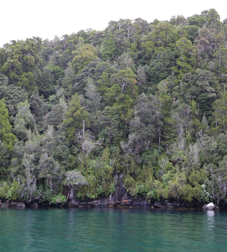
October 2017predominantly rocky (see photograph 1 below), however within some coves and
embayments, sandy beaches can be found (such as at Red Beach).
Photograph 1: A typical coastal interface of North Arm illustrating the rocky foreshore and steep vegetated
topography
2.18 The waterbody of North Arm is reasonably well contained by the relatively steep and
rocky shoreline. The widest part of the waterbody is between Chase Head and Diprose
Bay to the north, which measures 2.1km. Otherwise, North Arm typically has an
average width of between 1.1km and 1.3km. Whale Passage at 230m at its narrowest
point, is the shortest distance between land.
2.19 The waterbody, being calmer than waters associated with the Southern Ocean beyond
Pearl Island, retains reflective qualities of the sky and adjacent land and changes colour
throughout. The more sheltered bays are typically brown in colour, due to the numerous
tannin-coloured watercourses draining the land. Within the centre of North Arm, the
colour is typically bluer. Other than numerous buoys indicating the location of where
crayfish pots and cod pots 5 are located (see photograph 2 below), there is no other
modification 6 associated with the waterbody. Recreational dredging for scallops and
oysters has been reported, but the location, amount and effect is uncertain.
5
It is unknown whether these craypots observed during the site visit were actively used (or even associated with
commercial fishing purposes).
6
Excluding occasional recreational fishing.
Boffa Miskell Ltd | Port Pegasus/ Pikihatiti Salmon Farms | Natural Character, Landscape and Visual Amenity Effects Assessment | 11 October 2017 11Photograph 2: Buoys indicating the locations of the temporary storage of crayfish pots.
2.20 As outlined earlier, North Arm is relatively exposed to wave action through Big Ship
Passage, but Pearl Island in the east provides shelter from easterly and south-easterly
swells 7. North Arm is also relatively deep (compared to the shallower South Arm) with
depths of up to 50m found to the northwest of Pearl Island, with the remainder of the
mid-channels being approximately 30-40m deep 8.
2.21 Rocks in this part of Stewart Island are relatively complex with underlying granite
bedrock overlain with softer materials. Large boulders are sighted, especially the granite
protrusions on the Tin Range to the north-east of the area. Over time, watercourses
have and continue to drain the surrounding landscape, making channels between the
rock. The larger watercourses include Basin Creek which exits into Albion Inlet and
Pegasus Creek which drains via Belltopper Falls into the northern part of North Arm
(see photograph 3 below). Any sedimentation from these watercourses are considered
to be entirely natural due to limited or no current human modifications evident within the
catchments.
Photograph 3: Belltopper Falls
7
Cawthron Report 3047: Benthic Habitat Assessment: North Arm, Port Pegasus/ Pikihatiti, paragraph 2
8
Cawthron Report 3047: Benthic Habitat Assessment: North Arm, Port Pegasus/ Pikihatiti, paragraph 2
12 Boffa Miskell Ltd | Port Pegasus/ Pikihatiti Salmon Farms | Natural Character, Landscape and Visual Amenity Effects Assessment | 11
October 20172.22 Native vegetation covers the area and is generally mature and in some places original,
however due to past human activities and in some cases due to fire, some of this
vegetation is regrowth. Due to this the area has a largely intact ecosystem, extending
from the tops of the granite peaks to the floor of the seabed 9. The vegetation diversity is
reasonably high, with subalpine vegetation associated with the Tin Range readily
apparent, along with podocarp forests and shrublands, wetlands and coastal fringe
vegetation (see Figure 8 graphic attachment). The Conservation Management Strategy
(CMS) states that due to the large number of locally endemic species within these
habitats (which is not common elsewhere in New Zealand), this places a higher level of
importance on the vegetation. Furthermore, the CMS notes that the large-scale
naturalness, and the ecological linkages between the forest, alpine, coastal and
freshwater ecosystems is also important and rare in the broader New Zealand
context 10.
2.23 The CMS records that there are a number of birds that nest within the Port Pegasus/
Pikihatiti area, including kiwi, yellow-eyed penguins, Southern New Zealand dotterels,
Stewart Island wekas, titi/ sooty shearwater as well as numerous other terrestrial and
sea bird species 11. Other species, such as the red-crowned parakeet, and South Island
saddleback are also notable species common in the area. The Harlequin gecko is also
found within the area.
2.24 Port Pegasus supports a growing breeding population of New Zealand (NZ) sea lions
(Phocarctos hookeri) 12, that is also one of the priority breeding sites in the NZ Sea Lion
Threat Management Plan (NZSL TMP) 13. This species is designated as ‘Nationally
Critical’ by the NZ Classification System and ‘Endangered’ by the International Union of
Conservation of Nature 14.
2.25 Port Pegasus/ Pikihatiti generally retains a rich cultural heritage to iwi. This is
specifically the case where Port Pegasus/ Pikihatiti was used as a transit point to and
from the Titi Islands (Muttonbird Island off South West Cape).
2.26 The late 1800’s and early 1900’s saw tin mining occur on the Tin Range and whilst this
wasn’t extensively excavated due to the low grade of extracted tin, disturbance was
caused to some of the waterways. A very small settlement was apparent close to the
waterfront, with a hotel and post office (refer to image below).
9
Stewart Island/ Raikura Conservation Management Strategy, paragraph 8.5.3
10
Stewart Island/ Raikura Conservation Management Strategy, page 20
11
Stewart Island/ Raikura Conservation Management Strategy, paragraph 8.5.3
12
NIWA (Report No. 2017264WN) Review of potential NZ sea lion interactions with aquaculture at Port Pegasus/
Pikihatiti – prepared for DOC (August 2017), first bullet point under Executive Summary
13
New Zealand Sea Lion Threat Management Plan 2017-2022: http://www.doc.govt.nz/Documents/conservation/native-
animals/marine-mammals/nz-sea-lion-tmp/nz-sea-lion-threat-management-plan.pdf
14
NIWA (Report No. 2017264WN) Review of potential NZ sea lion interactions with aquaculture at Port Pegasus/
Pikihatiti – prepared for DOC (August 2017), first bullet point under Executive Summary
Boffa Miskell Ltd | Port Pegasus/ Pikihatiti Salmon Farms | Natural Character, Landscape and Visual Amenity Effects Assessment | 11 October 2017 13Photograph 4: Hotel and Post office at Port Pegasus
2.27 Tailings and other features also remain however are largely covered over by regrowth
of the vegetation.
2.28 Just north of Rosa Island was a freezing facility, used for the active fishing industry that
established itself in North Arm during the late 19th and early 20th centuries 15 (see Figure
9 graphic attachment).
Photograph 5: Composite photograph of Pegasus settlement in the 1930s. The large shed in the centre of
the image contains the third freezer and the smaller two sheds to the right are all that remained (at the
time) of the first freezer.
2.29 Some evidence of this is still apparent today, notably with the concrete platform of the
third freezer shed located by the water’s edge.
15
Refer also to the Stewart Island/ Rakiura Conservation Management Strategy, paragraph 8.5.4
14 Boffa Miskell Ltd | Port Pegasus/ Pikihatiti Salmon Farms | Natural Character, Landscape and Visual Amenity Effects Assessment | 11
October 2017Photograph 6: Location of the former freezer works in North Arm
2.30 A plan illustrating all known historical, cultural and archaeological sites in Port Pegasus/
Pikihatiti is contained within the Graphic Supplement as Figure 9.
2.31 In terms of recreation opportunities, there is a small, informal trail extending onto the Tin
Range, which connects with a small embayment just north of Diprose Bay (marked by a
small white ribbon close by the water’s edge). It is understood that this is unmarked
and seldom used. There is also a hunters’ hut, located on the western side of Pegasus
Passage 16. Kayaking and fishing also occurs in Port Pegasus however due to the
access being principally by boat, many recreational opportunities are very much
dictated by the weather conditions.
Photograph 7: North Pegasus Hunters Hut
2.32 Due to the location of North Arm, the area retains an overwhelming sense of
remoteness and isolation. The lack of modification amplifies the sense of wildness and
naturalness. The steep vegetated hills adjacent to the coast promotes the highest sense
16
DOC data reveals that the occupancy rate for each hut is between 100-180 days per year, with party sizes ranging
from 1 through to groups of 10 people. (Pegasus Hunter data 2014-2017, DOC excel spreadsheet)
Boffa Miskell Ltd | Port Pegasus/ Pikihatiti Salmon Farms | Natural Character, Landscape and Visual Amenity Effects Assessment | 11 October 2017 15of naturalness with experiential aspects changing around the ‘Arm’. Experiential aspects
can become more enclosed in many of the sheltered coves and more exposed within
the central part of the water. These very high sensory values also include the rich
sounds and smells of the area which adds to the area’s appeal. In general, a sense of
containment is gained within the arm, which provides shelter from the rough seas.
South Arm
2.33 South Arm extends in a south-westerly and north-easterly direction and provides more
open views to the south than North Arm due in part to the more varied topography that
contains and defines this part of Port Pegasus/ Pikihatiti. Noble Island and Anchorage
Island define the north-eastern extents of South Arm. Numerous embayments, including
Shipbuilders Cove and Islet Cove broaden the waterbody in parts to reach up to 2.8km
in width.
Image 3: South Arm of Port Pegasus
2.34 The noticeable difference in the above-water character of South Arm is its visual
association to the granite tors and stacks of Fraser Peaks (Gog and Magog) and Bald
Cone and the lower topography close to the water’s edge.
Photograph 8: Bald Cone and Magog tor evident in the distance
16 Boffa Miskell Ltd | Port Pegasus/ Pikihatiti Salmon Farms | Natural Character, Landscape and Visual Amenity Effects Assessment | 11
October 20172.35 Whilst retaining a similar sense of naturalness to North Arm, where no or very limited
modification is apparent, the landscape appears more open, and expressive of its
formative processes. As a consequence of the landform, parts of the South Arm appear
wider than the North Arm, although there is actually little difference when measured 17.
Aesthetically, South Arm rates strongly for its dramatic features, including rocky
outcrops (such as Pigeon House) granite tors and stacks (Bald Cone) and intimate long
and deep coves (such as Disappointment Cove and Fright Cove).
2.36 As with North Arm, a plan illustrating all known historical, cultural and archaeological
sites in Port Pegasus/ Pikihatiti is contained within the Graphic Supplement as Figure
9.
3.0 The Investigation
3.1 The investigation is looking at the potential to establish salmon farming in parts of North
Arm. Through an iterative design process, a number of indicative scenarios have been
developed, based on different fish production quantities. As outlined earlier two broad
areas have been explored within Port Pegasus, North Arm and Big Ship Passage.
Following further work by Cawthron, eight different scenarios were developed centred
on fixed 160m circumference pens (as opposed to pens of varying sizes) to test the
effects of various quantums of feed and number of pens.
3.2 This assessment assesses four different infrastructure scenarios, based on different
quantities of feed and number of pens. These are listed as Scenarios 1a, 2a, 3a and 4a.
A further set of scenarios have also been developed, based on scenarios (a), where the
same amount of infrastructure is required however their quantum of feed has been
increased. This second set of scenarios (listed as Scenarios 1b, 2b, 3b and 4b) is
based on increasing the density of fish. Refer to Table 1 earlier in this report and also
refer to Appendix 2 for a detailed explanation of the farm site selection and production
scenarios.
3.3 Specifically, the scenarios contain the following related infrastructure:
• For farms f1, f2, f3 and f4 all pens will be 160m circumference polar circles.
• For the smolt growing area (s1), the pens will be 100m circumference polar
circles.
• Four grow farms and one smolt farm will comprise each of the scenarios, with
the number of pens and quantum of feed varying for each scenario.
• The polar circles are typically dark in colour and lie low on the water. Predator
proof netting will be provided around the structure, again typically dark in
colour.
• Each farm area has been identified by a number (i.e. farm 1– or f1, f2, f3, f4
and s1 – for smolt 1) will be serviced by a floating barge. For farm areas f1, f2,
17
The South Arm is approximately 2.5km wide at its widest point (from Nelly Island to north of Shipbuilders Cove) and
8.5km long (from Sylvian Cove to Noble Island). The North Arm/ Big Ship Passage is approximately 2.3km in width at its
widest point (from just south of Chase Head to the head of Albion Inlet) and 6.2km in length (from Scout Bay to outer
part of Anchorage Island/ Pearl Island), averaging 1.3km in width.
Boffa Miskell Ltd | Port Pegasus/ Pikihatiti Salmon Farms | Natural Character, Landscape and Visual Amenity Effects Assessment | 11 October 2017 17f3 and f4, the barge will be a 600 tonne feed barge (with no accommodation) of
up to 40m in length, 12m in width and 5m high. For farm s1 (the smolt farm),
the barge includes accommodation and up to 400 tonnes of feed capacity. The
barges will need to be capable of withstanding significant weather, however can
be towed to areas of shelter if required. An example of the barge is illustrated
below:
Image 4: Computer image of the barge. Source: Akvagroup
3.4 Each scenario (in terms of its infrastructure) is outlined below in Table 2:
Table 2: Scenario by its infrastructure and numbers
Scenario Infrastructure Farming Areas Total surface
area (approx.)
f1 f2 f3 f4 s1
1a & 1b No. of pens 16 16 16 16 8 33 ha
No. of barges 1 1 1 1 1
2a & 2b No. of pens 8 10 14 14 6 24 ha
No. of barges 1 1 1 1 1
3a & 3b No. of pens 6 8 12 12 4 19 ha
No. of barges 1 1 1 1 1
4a & 4b No. of pens 4 6 8 10 4 14 ha
No. of barges 1 1 1 1 1
3.5 The farms are likely to comprise of the following elements:
18 Boffa Miskell Ltd | Port Pegasus/ Pikihatiti Salmon Farms | Natural Character, Landscape and Visual Amenity Effects Assessment | 11
October 2017• Sea cages – plastic or steel circular cages, grouped, with a 15-20m gap
between each cage. An example of this is illustrated below.
Image 5: An example of a black polar circle in the Marlborough Sounds (shown at 60m circumference)
• Steel or plastic floatation structures – these support the suspended grower nets
(forming the salmon farm cages), predator nets (see below) and walkways
(around, and sometimes over, the cages).
• Netting– these include the grower nets in the cages, bird netting over the top of
the cages and predator exclusion nets and barriers around the perimeter and
below the farm.
• Moorings and Anchors – includes the underwater mooring lines and anchoring
systems on the seafloor. These extend beyond the immediate extent of the
surface facilities.
• Lighting - navigational lighting, accommodation lighting and underwater lighting.
• Noise– from barges, activities on farm, above water and underwater sound
• Barges, as illustrated above.
3.6 Also, the floating barges on the water that are included as part of the scenarios will be
in recessive colours such as the karaka green, such as what is currently used for
salmon farm sites in the Marlborough Sounds by New Zealand King Salmon.
4.0 Statutory Planning Context
4.1 This section outlines the relevant planning provisions that relate to the project. An
assessment against relevant provisions is set out in Section 8 of this report.
4.2 There are a number of statutory documents that are relevant. These particularly relate
to legislation under the Resource Management Act, however there are also a range of
other relevant statutes. The relevant legislation includes:
4.2.1 The Resource Management Act 1991 (RMA) and associated legislation:
Boffa Miskell Ltd | Port Pegasus/ Pikihatiti Salmon Farms | Natural Character, Landscape and Visual Amenity Effects Assessment | 11 October 2017 19• New Zealand Coastal Policy Statement 2010 (NZCPS)
• Operative and Proposed Southland Regional Policy Statements
• Southland Regional Coastal Plan
• Operative and Proposed Southland District Plans
4.2.2 Other Statutes and related documents:
• National Parks Act 1980
• Conservation Act 1987
• Stewart Island/Rakiura Conservation Management Strategy
• Rakiura National Park Management Plan (2011-2021) March 2012
• Marine Mammals Protection Act 1978
• Wildlife Act 1953
Resource Management Act legislation
Resource Management Act 1991 (RMA)
4.3 As relevant to this assessment, the RMA outlines the following matters which must be
considered as part of this investigation.
4.4 Section 6 – Matters of National Significance
(a) the preservation of the natural character of the coastal environment (including the
coastal marine area), wetlands, and lakes and rivers and their margins, and the
protection of them from inappropriate subdivision, use and development,
(b) the protection of outstanding natural features and landscapes from inappropriate
subdivision, use and development:
4.5 Section 7 – Other Matters
(c) the maintenance and enhancement of amenity values,
(d) the maintenance and enhancement of the quality of the environment
4.6 ‘Amenity values’ is defined in the RMA as, “those natural or physical qualities and
characteristics of an area that contribute to peoples’ appreciation of its pleasantness,
aesthetic coherence, and cultural and recreational attributes”.
4.7 Visual amenity is a component of the overall amenity of a place. Amenity includes a
combination of many factors, such as visual amenity, ambient noise, air quality, and
recreational and cultural attributes. It is noted that the effects of the scenarios with
respect to these other elements of amenity beyond visual amenity (i.e. noise, air quality,
recreational and cultural attributes) are dealt with comprehensively in other reports.
This report has focussed on visual amenity effects as well as other matters of relevance
under the Resource Management Act.
20 Boffa Miskell Ltd | Port Pegasus/ Pikihatiti Salmon Farms | Natural Character, Landscape and Visual Amenity Effects Assessment | 11
October 2017New Zealand Coastal Policy Statement 2010 (NZCPS)
4.8 The NZCPS is a national document intended to state policies in order to achieve the
purpose of the Resource Management Act in relation to the coastal environment of New
Zealand. It contains a number of Policies that are relevant to the project.
4.9 Policy 1: Extent and Characteristics of the Coastal Environment provides a list of
characteristics as a basis for establishing what might be included within the coastal
environment. It is noted that this project is wholly contained within the coastal
environment.
4.10 Most pertinent to the natural character, landscape and visual amenity elements of this
project will be Policy 13: Preservation of Natural Character, Policy 14 Restoration of
Natural Character and Policy 15: Natural Features and Natural Landscapes.
4.11 Policy 13 Preservation of Natural Character
(1) To preserve the natural character of the coastal environment and to protect it from
inappropriate subdivision, use, and development:
(a) avoid adverse effects of activities on natural character in areas of the coastal
environment with outstanding natural character; and
(b) avoid significant adverse effects and avoid, remedy or mitigate other adverse
effects of activities on natural character in all other areas of the coastal environment;
(2) Recognise that natural character is not the same as natural features and
landscapes or amenity values and may include matters such as:
(a) natural elements, processes and patterns;
(b) biophysical, ecological, geological and geomorphological aspects;
(c) natural landforms such as headlands, peninsulas, cliffs, dunes, wetlands, reefs,
freshwater springs and surf breaks;
(d) the natural movement of water and sediment;
(e) the natural darkness of the night sky;
(f) places or areas that are wild or scenic;
(g) a range of natural character from pristine to modified;
(h) experiential attributes, including the sounds and smell of the sea; and their context
or setting
4.12 Natural Character is not defined in either the RMA or the NZCPS. The New Zealand
landscape profession defines natural character as, ‘the expression of natural elements,
patterns and processes in a landscape’ 18. Natural character is the term used to
describe the natural elements of coastal environments as the expression of natural
elements, patterns and processes in a landscape (or the ‘naturalness’) where the
degree of ‘naturalness’ depends on:
• The extent to which natural elements, patterns and processes occur.
18
Best Practice Note: Landscape Assessment and Sustainable Management 10.1, NZILA, page 5
Boffa Miskell Ltd | Port Pegasus/ Pikihatiti Salmon Farms | Natural Character, Landscape and Visual Amenity Effects Assessment | 11 October 2017 21• The nature and extent of modifications to the landscape, seascape and
ecosystems
4.13 Policy 15 of the NZCPS is relevant as the majority of Stewart Island/ Rakiura (including
the whole of Port Pegasus, including its waters) is an Outstanding Natural Landscapes
(ONL) within the District and Regional plans and under separate assessment. Policy 15
also relates to other natural features and natural landscapes.
4.14 Policy 15 Natural features and natural landscapes
To protect the natural features and natural landscapes (including seascapes) of the
coastal environment from inappropriate subdivision, use, and development:
(a) avoid adverse effects of activities on outstanding natural features and outstanding
natural landscapes in the coastal environment; and
(b) avoid significant adverse effects and avoid, remedy, or mitigate other adverse
effects of activities on other natural features and natural landscapes in the coastal
environment;
Operative and Proposed Southland Regional Policy Statements
4.15 The proposed Southland Regional Policy Statement is largely operative and includes a
chapter dealing with coastal issues. The relevant objectives seek to provide clear
direction on appropriate and inappropriate activities within the coastal environment. In
particular Objective COAST.2 states “Infrastructure, ports, energy projects, aquaculture,
mineral extraction activities, subdivision, use and development in the coastal
environment are provided for and able to expand, where appropriate, while managing
the adverse effects of those activities”.
4.16 In addition, there are objectives seeking to maintain or enhance coastal water quality
and ecosystems, and to restore, rehabilitate or preserve the natural character of the
coastal environment. An additional objective has been sought through submissions in
relation to marine farming and this point remains under appeal.
4.17 The intention through the policy framework is that the regional and district plans will
clearly set out locations within the coastal environment where activities are appropriate,
inappropriate or where they need further consideration through an approval process.
This type of approach would provide greater certainty over where activities may be
expected to develop over time, including areas appropriate for aquaculture activities.
Southland Regional Coastal Plan
4.18 The purpose of the Regional Coastal Plan is to set out the provisions that manage
activities in the coastal marine area. The Plan includes a section setting out the values
of the coastal marine area and in relation to Stewart Island and other offshore islands,
the Plan sets out the key values as including:
• Areas containing significant values – including all of the coast of Stewart Island
and the waters within 5 km of the mean high water mark. Specifically
mentioned is the brachiopod habitat in Port Pegasus.
• Marine mammals and birds, and the feeding and breeding role that Stewart
Island plays for many species.
22 Boffa Miskell Ltd | Port Pegasus/ Pikihatiti Salmon Farms | Natural Character, Landscape and Visual Amenity Effects Assessment | 11
October 2017• Ecosystems, vegetation and fauna habitats, with a particular emphasis on the
unmodified state of the habitat being of significant value. Again, Port Pegasus
is mentioned for its black coral colonies and brachiopod communities.
• Natural character and landscape values, with an emphasis on very high natural
character and outstanding quality.
• Heritage and archaeological values.
• Coastal landforms and associated processes.
• Recreational and amenity values, with many visitor activities available.
• Commercial values and anchorage value, with Port Pegasus mentioned as
containing extremely high anchorage value.
4.19 The Plan also includes an appendix setting out landscape values and, within this, Port
Pegasus is identified as having the highest possible naturalness rating. Specifically
mentioned is that high impact water-based activities e.g. salmon farming has the
potential to adversely affect natural character.
4.20 The Plan also contains rules relating to activities within the coastal marine area and
includes a section on marine farming. The key objective for these activities is to avoid,
remedy or mitigate any adverse effects of marine farming operations. Marine farming in
the Stewart Island waters, including Port Pegasus, is identified in rule 15.1.54 as
prohibited for the following reasons:
Explanation - Port Pegasus is a traditional safe anchorage on the leeward side of
Stewart Island. The area has outstanding natural character and is recognised for the
clarity of water in its sandy bays. Black coral colonies exist here and both Port
Pegasus and Paterson Inlet contain brachiopod communities. Brachiopods are of
scientific interest because their phylum has survived for approximately 600 million
years with no basic change. Brachiopods are common as fossils throughout the
world, but are not common in modern seas. They have been designated by the
International Union for Conservation of Nature and Natural Resources (IUCN) as
threatened internationally. The area is important for a number of species of birds
including giant petrels, New Zealand dotterels, yellow-eyed and Fiordland crested
penguins. Hooker sea-lions also breed in the area.
Southland District Plans
4.21 The District Plans (operative and proposed) relate to the use of land above mean high
water springs and thus have less relevance to the use of Port Pegasus waters. The
proposed Plan (which is largely operative) does identify the land surrounding Port
Pegasus as being an Outstanding Natural Landscape. The Plan expects that
Outstanding Natural Features and Landscapes will be protected from inappropriate
subdivision, land use and development.
4.22 The proposed District Plan also includes a section on the Coastal Environment, which
has a focus on ensuring that activities are managed to avoid adverse effects particularly
on natural character values, outstanding natural landscapes and other key values.
Boffa Miskell Ltd | Port Pegasus/ Pikihatiti Salmon Farms | Natural Character, Landscape and Visual Amenity Effects Assessment | 11 October 2017 23You can also read