Precise Point Positioning with single and dual-frequency multi-GNSS Android smartphones
←
→
Page content transcription
If your browser does not render page correctly, please read the page content below
Precise Point Positioning with single and dual-frequency
multi-GNSS Android smartphones
Umberto Robustellia , Valerio Baiocchib , Laura Marconic , Fabio Radicionic and
Giovanni Puglianoa
a
  Department of Engineering, Parthenope University of Naples, Naples, Italy
b
  Department of Civil Constructional, and Environmental Engineering DICEA, Sapienza University of Rome
Rome, Italy
c
  Department of Engineering, University of Perugia Perugia, Italy

                                         Abstract
                                         The new generation of Android smartphones is equipped with high performance Global Navigation
                                         Satellite System (GNSS) chips capable of tracking dual frequency multi-constellation data. Moreover,
                                         starting from version 9 of Android users can disable the duty cycle power saving option thus good
                                         quality pseudorange and carrier phase raw data are available thus the application of Precise Point
                                         Positioning (PPP) algorithm becomes more and more interesting. The main aim of this work is
                                         to assess the PPP performance of the first dual-frequency GNSS smartphone produced by Xiaomi
                                         equipped with a Broadcom BCM47755. The advantage of acquire dual frequency data is highlighted
                                         by comparing the performance obtained by Xiaomi with that of a single frequency smartphone the
                                         Samsung S8. The horizontal and vertical accuracy achieved by Xiaomi are of 0.51 m and 6 m
                                         respectively while those achieved by Samsung are 5.64 m for 15 m for horizontal and vertical.

                                         Keywords
                                         Raw data, Android Smartphone, PPP, Xiaomi MI 8, Samsung S8, Duty Cycle

1. Introduction
The ability to access raw data started in May 2016 when Google announced that raw GNSS
measurements would be available to apps in the Android Nougat operating system was a
revolution. From that day on, it became possible to use D-GNSS algorithms with mobile
phone, try to reduce errors in urban areas, to fuse GNSS data with data from the other
phone sensors such as the Inertial Measurement Unit (IMU). Since that date many steps
forward have been made thanks also to the appearance of new chips designed exclusively for
mobile devices. Having access to smartphone raw data together with all the GNSS products
made available free of charge by organizations such as International GNSS Service (IGS) [1, 2]
researchers have begun to focus their studies on this area. The first studies conducted on mobile
devices used the measures acquired by the Google/HTC Nexus 9 tablet because it was the only
tablet/smartphone that allowed the disabling of the duty cycle guaranteeing continuous phase
observations (See Realini et al., [3], Zhang et al. [4], Li and Geng [5] ). With the advent of

ICL-GNSS 2020 WiP Proceedings, June 02–04, 2020, Tampere, Finland
email: umberto.robustelli@uniparthenope.it (.U. Robustelli); valerio.baiocchi@uniroma1.it (V. Baiocchi);
laura.marconi@unipg.it (.L. Marconi); fabio.radicioni@unipg.it (.F. Radicioni);
giovanni.pugliano@uniparthenope.it (.G. Pugliano)
orcid: 0000-0002-5486-7721 (.U. Robustelli); 0000-0003-4491-7868 (V. Baiocchi); 0000-0003-3465-1525 (.L.
Marconi); 0000-0002-1377-4588 (.F. Radicioni); 0000-0002-8177-1370 (.G. Pugliano)
                                       ⃝
                                       c 2020 Copyright for this paper by its authors.
                                       Use permitted under Creative Commons License Attribution 4.0 International (CC BY 4.0).
    CEUR
    Workshop
    Proceedings
                  http://ceur-ws.org
                  ISSN 1613-0073       CEUR Workshop Proceedings (CEUR-WS.org)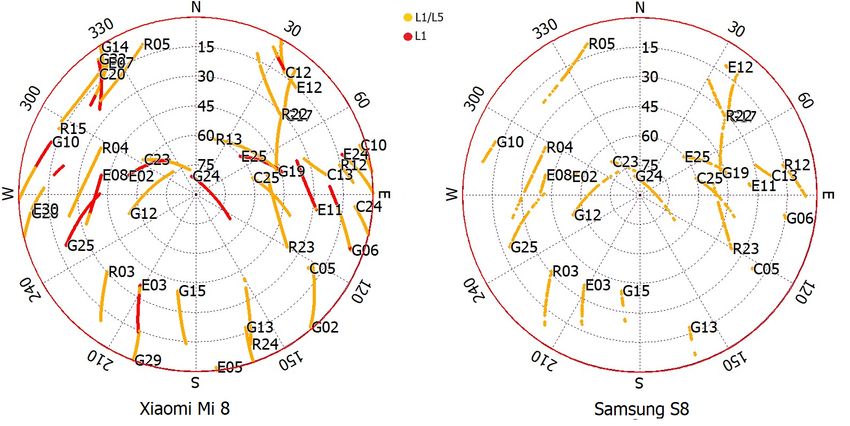
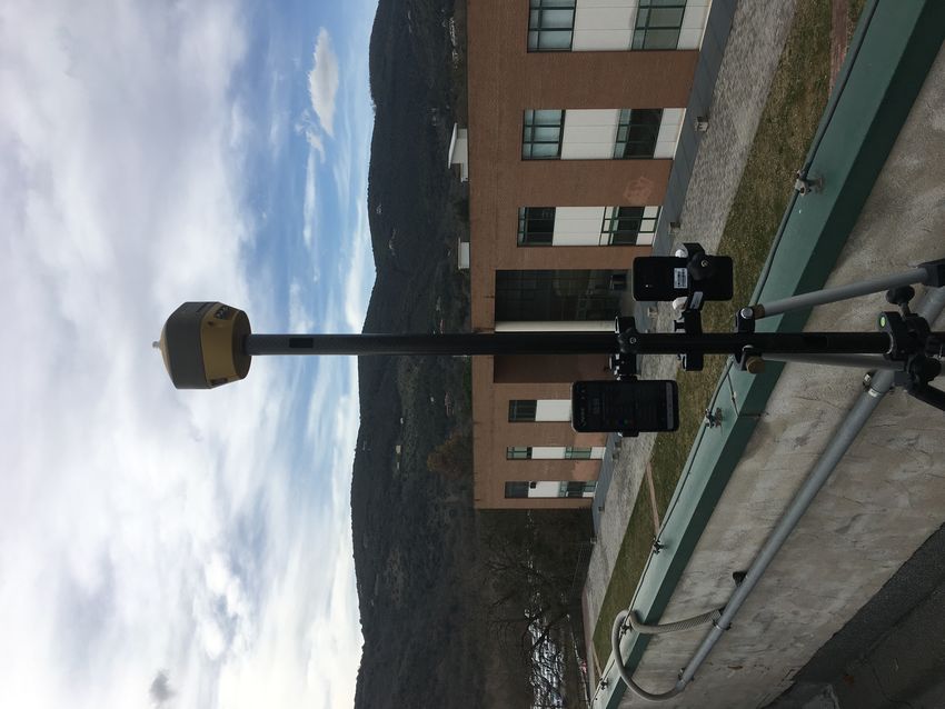
new generation smartphones equipped with increasingly high performance GNSS chips, the
use of PPP algorithms for positioning is becoming increasingly widespread. This is due to the
fact that the PPP algorithm does not need to use the measurements coming from a second
receiver typically belonging to a GNSS network. Gill et al. [6] applied single-frequency PPP
methodology to measurements acquired by a Nexus 9 tablet achieving an accuracy of 0.28 m,
0.25 m and 0.51 m for north, east and up component. A further step forward occurred when in
May 2018 appeared the world’s first dual-frequency GNSS smartphone produced by Xiaomi.
It is equipped with a Broadcom BCM47755 chipset. It is a multi-constellation, dual-frequency
(E1/L1+E5a/L5) GNSS chip able to record code and carrier phase measurements on GPS L1
& L5, GLONASS L1, Galileo E1 & E5a, BeiDou and QZSS L1 & L5. Until then, the GPS
chipsets mounted on smartphones were single-frequency. In some cases, they were already
multi-constellation, but the mono frequency extremely limited the performance because the
ionospheric error could not be eliminated but only estimated using a single frequency model like
Klobuchar one [7]. Thus researchers starting to apply dual frequency PPP algorithm to this
data. Wu et al. in 2019 [8] analyzed the positioning performance of the Xiaomi Mi 8 in static
and kinematic modes applying dual-frequency PPP algorithm to the GPS L1/L5 and Galileo
E1/E5a signals processing data through an algorithm modified from RTKLIB. In the static
mode, the root mean square (RMS) position errors of the dual-frequency smartphone PPP
solutions in the east, north, and up directions were 0.22 m, 0.04 m, and 0.11 m respectively
after about 300 minutes. Finally Wen et al. ([9] replaced the Mi 8’s embedded GNSS antenna
with an external survey-grade one and performed precise point positioning ambiguity resolution
(PPP-AR) achieving centimeter-level accuracy after about one hour. The main aim of this
work is to assess the PPP performance of Xiaomi Mi 8 (using its embedded antenna) taking
advantage of all the potential offered by the Broadcom BCM47755 chip, unlike the research
mentioned above, our processing strategy will be based on the use of all the constellations
received by the smartphone namely GPS, GLONASS, Galileo and BeiDou.

2. Methods and Data
Precise Point Positioning algorithms are well known and ample literature is available (see
[10] for an exhaustive description). The data collection has been carried out by using two
Android smartphones and a geodetic receiver installed on the roof of a two-storey building
of the Engineering Department at the University of Perugia in an open-sky area. Geo ++
RINEX Logger app was used to acquire 1 Hz data in RINEX 3.03 format over a time span
of about 1 hour (13:20 - 14:20 UTC) on March 4, 2019. Figure 1 shows the setup of the two
smartphones and the geodetic GNSS receiver/antenna Topcon Hiper HR. This configuration
was chosen in order to simultaneously acquire measurements from the three receivers. The
first smartphone used was a Xiaomi Mi 8 running Android 9 operating system, embedded with
a Broadcom BCM47755 chip. This chip is the first dual frequency chip expressly developed
for a smartphone [7]. It provides access both to the L1/E1 frequency for GPS, GLONASS,
Galileo, BeiDou and to L5 and E5a frequencies for GPS and Galileo, respectively.
   The second smartphone employed was a Samsung Galaxy S8 equipped with a Exynos 8895
Octa – EMEA, running Android 7 operating system. It support only L1/E1 frequency for
GPS, GLONASS, Galileo, BeiDou, QZSS, SBAS constellations.
   The geodetic receiver used was a Topcon HiPer HR with integrated antenna capable of
receiving GPS, GLONASS, Galileo, BeiDou, QZSS, SBAS signals on all frequencies.
Figure 1: The location where the experimental data were collected and the equipment used in this study

   The data acquired by the geodetic receiver were post processed in the static relative posi-
tioning mode. In detail, a Continuously Operating Reference Station (CORS) of the Umbria
GNSS Network ([11, 12]) was used as base station. The results obtained were used as reference
in order to evaluate the accuracy achieved by the two smartphones.
   Starting from version 9 of Android users have the possibility to disable the duty cycle via
software. This can be done by enabling the “Force full GNSS measurements” item in the
developers menu. Thus for the Xiaomi Mi 8 duty cycle has been disabled while for Samsung
S8 this was not possible.
Figure 2: Sky-plots of Perugia sites’ smartphones data. Xiaomi Mi 8 and Samsung S8 data are depicted in
left and right subplot respectively. The observational arcs represented in red refer to satellites whose signals
are acquired both on E1/L1 and E5a/L5 frequencies. Arcs in orange refer to satellites whose signals are
acquired E1/L1 signals. It can be noticed that Samsung S8 smartphone does not acquire E5a/L5 signals.

3. Results
As discussed in 2 section the smartphones and geodetic receiver have been installed on the roof
of a building in an open-sky area. Figure 2 shows the sky-plots of Xiaomi Mi 8 and Samsung
S8 in the left and right subplot respectively. The arcs depicted in red refer to satellites whose
signals are acquired both on E1/L1 and E5a/L5 while arcs in orange represent satellites whose
signals are acquired only on L1/E1 frequencies. From the figure it is clear that the Samsung
S8 only receives the E1/L1 signals.
   In figure 3 are shown the number of visible satellites with cut-off angle of 15 degrees and
the evolution of GDOP versus time in top subplot and in bottom subplot respectively. Data
relative to Xiaomi Mi 8 are depicted in blue while those relative to Samsung S8 are depicted
in red. By observing the figure it can be noticed that the number of visible satellites acquired
by Xiaomi Mi 8 is always higher than those acquired by Samsung S8. This is expected due
to the higher tracking performance of Broadcom chip. Clearly the higher number of acquired
satellites also affects the GDOP values which are always better for the Xiaomi Mi 8. Finally we
want to point out the presence of some data gaps present in the data acquired by Samsung S8
(for example around 134600, 136700, 137600 seconds) caused by unwanted hardware stand-by.
   Despite these differences, however, we can state that the number of acquired satellites and
their geometry are good for both smartphones having an average number of visible satellites
equal to 22 for the Xiaomi and 15 for the Samsung and an average of GDOP of 1.3 and 1.7
respectively.
   In order to assess the quality of received signals we compared the average of signal to noise
ratio of each satellites received by Xiaomi Mi 8 and Samsung S8 with those of the same satellites
received by geodetic receiver on L1/E1 frequency. This comparison is showed in figure 4: green,
Figure 3: In the top subplot are shown the number of visible satellite with elevation angle cut-off of 15
degree versus epoch for Xiaomi Mi 8 and Samsung S8 plotted in blue and red respectively. The bottom
subplot shows the evolution of GDOP parameter respect to GPS epoch for both the smartphones.

Figure 4: Mean SNR L1 comparison between Topcon, Xiaomi Mi 8 and Samsung S8 depicted in green, blue
and red respectively. Figure is divided in four subplots for readability: from top to bottom are shown GPS,
GLONASS, Galileo and BeiDou satellites.

blue and red bars represent Topcon, Xiaomi Mi 8 and Samsung S8 respectively. Due the high
number of satellites the comparison figure has been divided in four subplots representing the
four constellations used. The figure clearly highlights the better performance of Xiaomi Mi 8
with respect to Samsung S8. Moreover observing the subplot relative to BeiDou (the bottom
one) it can be noticed that only the geodetic receiver tracks C11, C26, C32 and C34 satellites.
  Results are obtained using the Demo5 b33a (downloadable from http://rtkexplorer.com/
download/demo5-b33a-binaries modified version of the RTKLIB software originally developed
Figure 5: Scatter plot of L1/E1 PPP position error. Blue markers represent errors obtained by using Xiaomi
Mi 8 measurements, red circles represent error for Samsung S8.

by Takasu ( [13, 14]), using the PPP static algorithm, setting forward and backward option for
filter solution, a cutoff angle of 15 degrees. Precise ephemeris and clocks correction used are
the final CODE (Center for Orbit Determination in Europe) products. We also considered the
earth rotation parameters (ERP) and satellite antenna corrections provided by IGS for PCV
(phase center variations). For the ambiguity resolution we used the “continuous” method
with a threshold equal to 30 to guarantee a better and more feasible estimation (See Dabove
[15, 16]).
   We want to emphasize that currently there are a large number of online applications that
allow raw data PPP processing. In this study we also processed data by using the CSRS-PPP
(Canadian Spatial Reference System) service [17]. However we will show the results obtained
using RTKLIB.
   Many processing cases using different combinations of GNSS systems have been investigated.
However in order to facilitate the readability of the article, in this section are shown only the
results obtained using signals from all the tracked constellations namely: GPS, GLONASS,
Galileo and BeiDou constellation with the exception of Milena and Doresa Galileo satellites
due to their elliptical orbits ([18, 19, 20, 21]). All the achieved results are summarized in tables
1 and 2. Firsts test are conducted using L1/E1 single frequency PPP algorithm in order to
compare results achieved by the two different smartphones. Figure 5 shows the scatter plot of
achieved results, two different scales are used in order to get better readability. Blue markers
represent errors obtained by using Xiaomi Mi 8 measurements, red circles represent error for
Samsung S8. The horizontal accuracy achieved is of 3.15 m and 5.75 m for Xiaomi Mi 8 and
Samsung S8 respectively.
   In figure 6 are depicted east, north and up solution components in subplot a, b and c
respectively for Xiaomi Mi 8 (in blue) and Samsung S8 (in red). Two things are worth noting.
The first is that in this test the vertical accuracy of the Xiaomi (about 20 m) is worse than
that of the Samsung of about 5 m. The second is that the number of positions obtained by
Figure 6: Xiaomi MI 8 (in blue) and Samsung S8 point (in red) PPP solution components. Subplots a, b,
c show east, north and up components respectively.

Table 1
Performance of single and dual-frequency PPP algorithms for Xiaomi Mi8 ans Samsung S8 Android smart-
phones using all constellations.
                                                       RMS (m)                #
                                              East   North  Up     Horiz.   solut.
                    S8 (L1/E1)                0.75   5.70  14.95   5.75      684
                    Mi 8 (L1/E1)              0.10   3.15  19.11   3.15     3607
                    Mi 8 (L1/E1+L5/E5a)       0.15   3.35  20.38   3.35     3581
                    Mi 8 (ionospheric-free)   0.50   0.12  6.49    0.52     1756

Samsung S8 are 684 while those obtained by Xiaomi Mi 8 are 3607. This is very evident by
observing in the figure numerous gaps in the red line probably due to the activation of the
duty cycle power saving mechanism.
   In order to take full advantage of the potential of the Broadcom chipset embedded in the Xi-
aomi, further processing has been carried out. By exploiting the dual frequency measurements,
it was possible to use the ionospheric-free combination in order to eliminate the first-order iono-
spheric error.
   The scatter plot of this analysis is shown in figure 7. Blue markers represent errors obtained
by using Xiaomi Mi 8 measurements. The horizontal accuracy achieved expressed in terms of
DRMS is 0.52 m. East, north and up solution components are depicted in the subplot a, b and
c of figure 8 respectively. The vertical RMS achieved is 6.0 m and the number of positions is
equal to 1756.
   The statistics related to all the processing carried out with different combinations of GNSS
systems are shown in table 1, and 2.
Figure 7: Scatter plot of ionospheric-free PPP position error. Blue markers represent errors obtained by using Xiaomi Mi 8. Figure 8: Xiaomi Mi 8 PPP ionospheric-free solution components. Subplots a, b, c show east, north and up components respectively. 4. Discussion and Conclusion We analyzed and assessed Xiaomi Mi 8 and Samsung S8 Android smartphone performance in open sky environment using PPP algorithms. More than twenty different elaborations have been carried out. E1/L1 single frequency scatter plots reveals a better horizontal accuracy for Xiaomi Mi 8 with respect to Samsung S8. Vice versa the vertical accuracy achieved is better for Samsung than Xiaomi. However analyzing the east, north, up coordinate error plots in time domain we found that the number of solution achieved by Samsung S8 is about 1/6 than those achieved
Table 2
Performance of single and dual-frequency PPP algorithms for Xiaomi Mi 8 and Samsung S8 Android smart-
phones using only GPS and Galileo constellations.
                                                       RMS (m)                #
                                              East   North  Up     Horiz.   solut.
                    S8 (L1/E1)                0.50   5.71  14.70   5.74      489
                    Mi 8 (L1/E1)              0.58   2.76  18.43   2.82     3595
                    Mi 8 (L1/E1+L5/E5a)       0.60   2.54  20.0    2.62     3556
                    Mi 8 (ionospheric-free)   0.93   0.37  5.80    1.00     1875

by Xiaomi Mi 8. This could be addressed to the activation of the duty cycle power saving
mechanism; in particular, Samsung S8 carrier phase measurements are affected by cycle slips.
  Xiaomi Mi 8 dual frequency L1/E1 & L5/E5a scatter plot shows an horizontal accuracy of
0.52 m while the vertical RMS is 6.0 m. By observing east, north, up coordinate error plots
in time domain it can be noticed that the dual frequency PPP algorithm takes about 350
seconds before providing solutions with a fairly good continuity unlike the single frequency
PPP algorithm.
  To facilitate the readability of the article, in the previous section we have chosen to show only
some graphics of the elaborations carried out. By comparing results achieved by Xiaomi in both
ionospheric-free and dual frequency strategy it can be noticed that the exclusion of GLONASS
and BeiDou constellations (table 2) worsens the accuracy obtained when all constellations data
are used (table 1).
  Results obtained show that the Xiaomi Mi 8 dual-frequency multi-constellation smartphone
can be used in application with low precision requirements such as map updating and cadastral
survey.

References
 [1] J. M. Dow, R. E. Neilan, C. Rizos, The international gnss service in a changing landscape
     of global navigation satellite systems, Journal of geodesy 83 (2009) 191–198.
 [2] J. M. Dow, The igs strategic plan and future, www.igs.org (2013).
 [3] E. Realini, S. Caldera, L. Pertusini, D. Sampietro, Precise gnss positioning using smart
     devices, Sensors 17 (2017) 2434.
 [4] X. Zhang, X. Tao, F. Zhu, X. Shi, F. Wang, Quality assessment of gnss observations from
     an android n smartphone and positioning performance analysis using time-differenced
     filtering approach, Gps Solutions 22 (2018) 70.
 [5] G. Li, J. Geng, Characteristics of raw multi-gnss measurement error from google android
     smart devices, GPS Solutions 23 (2019) 90.
 [6] M. Gill, S. Bisnath, J. Aggrey, G. Seepersad, Precise point positioning (ppp) using low-cost
     and ultra-low-cost gnss receivers, in: Proceedings of the ION GNSS, 2017, pp. 226–236.
 [7] U. Robustelli, V. Baiocchi, G. Pugliano, Assessment of dual frequency gnss observations
     from a xiaomi mi 8 android smartphone and positioning performance analysis, Electronics
     (Switzerland) 8 (2019). doi:10.3390/electronics8010091.
 [8] Q. Wu, M. Sun, C. Zhou, P. Zhang,                      Precise point positioning using
     dual-frequency gnss observations on smartphone,                 Sensors (Switzerland) 19
(2019). URL: https://www.scopus.com/inward/record.uri?eid=2-s2.0-85066060689&doi=
10.3390%2fs19092189&partnerID=40&md5=accfffa636601d6effe7503aa2a8e0c0. doi:10.
3390/s19092189.
[9] Q. Wen, J. Geng, G. Li, J. Guo, Precise point positioning with ambiguity resolution using
an external survey-grade antenna enhanced dual-frequency android gnss data, Measure-
ment (2020) 107634.
[10] P. Teunissen, O. Montenbruck, Springer handbook of global navigation satellite systems,
Springer, 2017.
[11] F. Radicioni, A. Stoppini, La nuova rete gnss multicostellazione dell’umbria, GEOmedia
23 (2019).
[12] G. Dardanelli, M. Lo Brutto, C. Pipitone, Gnss cors network of the university of palermo:
Design and first analysis of data, Geographia Technica 15 (2020).
[13] T. Takasu, Ppp ambiguity resolution implementation, in: RTKLIB v 2.4.2, PP-RTK and
open standards symposium, March 12-13, Frankfurt am Main, Germany, 2012.
[14] T. Takasu, Rtklib: an open source program package for gnss positioning, in: RTKLIB:
an open source program package for GNSS positioning, 2016. Http://www.rtklib.com.
[15] P. Dabove, N. Linty, F. Dovis, Analysis of multi-constellation gnss ppp solutions under
phase scintillations at high latitudes, Applied Geomatics (2019) 1–8.
[16] P. Dabove, V. Di Pietra, Single-baseline rtk positioning using dual-frequency gnss receivers
inside smartphones, Sensors 19 (2019) 4302.
[17] Canadian spatial reference system, https://www.nrcan.gc.ca/, ???? Accessed: 2020-02-20.
[18] U. Robustelli, G. Pugliano, Assessment of pseudorange measurements of galileo foc satel-
lites with incorrect highly eccentric orbits, volume 2116, 2019. doi:10.1063/1.5114288.
[19] U. Robustelli, G. Pugliano, Galileo single point positioning assessment including foc
satellites in eccentric orbits, Remote Sensing 11 (2019). doi:10.3390/rs11131555.
[20] U. Robustelli, G. Benassai, G. Pugliano, Signal in space error and ephemeris validity
time evaluation of milena and doresa galileo satellites, Sensors (Switzerland) 19 (2019).
doi:10.3390/s19081786.
[21] U. Robustelli, G. Benassai, G. Pugliano, Accuracy evaluation of doresa and milena
galileo satellites broadcast ephemerides, 2019, pp. 217–221. doi:10.1109/MetroSea.2018.
8657859.You can also read