Preparing the New Phase of Argo: Scientific Achievements of the NAOS Project - Archimer
←
→
Page content transcription
If your browser does not render page correctly, please read the page content below
ORIGINAL RESEARCH
                                                                                                                                            published: 14 October 2020
                                                                                                                                      doi: 10.3389/fmars.2020.577408

                                            Preparing the New Phase of Argo:
                                            Scientific Achievements of the NAOS
                                            Project
                                            Pierre-Yves Le Traon 1,2* , Fabrizio D’Ortenzio 3 , Marcel Babin 4 , Edouard Leymarie 3 ,
                                            Claudie Marec 4,5,6 , Sylvie Pouliquen 1 , Virginie Thierry 7 , Cecile Cabanes 6,7 ,
                                            Hervé Claustre 3 , Damien Desbruyères 7 , Leo Lacour 4,5 , Jose-Luis Lagunas 4,5,8 ,
                                            Guillaume Maze 7 , Herle Mercier 7 , Christophe Penkerc’h 3 , Noe Poffa 1 , Antoine Poteau 3 ,
                                            Louis Prieur 3 , Virginie Racapé 7 , Achim Randelhoff 4,5 , Eric Rehm 4,5 ,
                                            Catherine Marie Schmechtig 9 , Vincent Taillandier 3 , Thibaut Wagener 10 and
                                            Xiaogang Xing 11
                                            1
                                              Ifremer, Plouzané, France, 2 Mercator Ocean International, Ramonville-Saint-Agne, France, 3 CNRS-INSU, Laboratoire
                                            d’Océanographie de Villefranche, Sorbonne Université, Villefranche-Sur-Mer, France, 4 UMI 3376 Takuvik, Joint International
                                            Laboratory, Département de Biologie et Québec-Océan, Université Laval, Québec, QC, Canada, 5 Centre National de la
                          Edited by:        Recherche Scientifique, Paris, France, 6 CNRS, IRD, Unité Mixte de Service 3113, IUEM, Univ. Brest, Plouzané, France,
                    Laura Lorenzoni,        7
                                              CNRS, Ifremer, IRD, Laboratoire d’Océanographie Physique et Spatiale (LOPS), IUEM, Univ. Brest, Plouzané, France,
    National Aeronautics and Space          8
                                              Recherche et Développement pour la Défense Canada – Centre de Recherches de l’Atlantique, Dartmouth, NS, Canada,
 Administration (NASA), United States       9
                                              CNRS, Observatoire des Sciences de l’Univers Ecce Terra, Sorbonne Université, Paris, France, 10 CNRS, IRD, MIO UM
                       Reviewed by:         110, Aix Marseille Univ., Université de Toulon, Marseille, France, 11 State Key Laboratory of Satellite Ocean Environment
                Bozena Wojtasiewicz,        Dynamics, Second Institute of Oceanography, Ministry of Natural Resources, Hangzhou, China
   Oceans and Atmosphere (CSIRO),
                             Australia
               Borja Aguiar-González,       Argo, the international array of profiling floats, is a major component of the global ocean
    University of Las Palmas de Gran        and climate observing system. In 2010, the NAOS (Novel Argo Observing System)
                       Canaria, Spain
                                            project was selected as part of the French “Investissements d’Avenir” Equipex program.
                  *Correspondence:
                                            The objectives of NAOS were to consolidate the French contribution to Argo’s core
                  Pierre-Yves Le Traon
        pierre.yves.le.traon@ifremer.fr;    mission (global temperature and salinity measurements down to 2000 m), and also to
        pierre-yves.letraon@mercator-       develop the future generation of French Argo profiling floats and prepare the next phase
                               ocean.fr
                                            of the Argo program with an extension to the deep ocean (Deep Argo), biogeochemistry
                   Specialty section:       (BGC-Argo) and polar seas. This paper summarizes how NAOS has met its objectives.
         This article was submitted to      The project significantly boosted France’s contribution to Argo’s core mission by
                   Ocean Observation,
               a section of the journal     deploying more than 100 NAOS standard Argo profiling floats. In addition, NAOS
          Frontiers in Marine Science       deployed new-generation floats as part of three scientific experiments: biogeochemical
           Received: 29 June 2020           floats in the Mediterranean Sea, biogeochemical floats in the Arctic Ocean, and deep
      Accepted: 14 September 2020
        Published: 14 October 2020
                                            floats with oxygen sensors in the North Atlantic. The experiment in the Mediterranean
                              Citation:
                                            Sea, launched in 2012, implemented and maintained a network of BGC-Argo floats
            Le Traon P-Y, D’Ortenzio F,     at basin scale for the first time. The 32 BGC-Argo floats deployed and about 4000
       Babin M, Leymarie E, Marec C,        BGC profiles collected have vastly improved characterization of the biogeochemical and
  Pouliquen S, Thierry V, Cabanes C,
Claustre H, Desbruyères D, Lacour L,        ecosystem dynamics of the Mediterranean. Meanwhile, experiments in the Arctic and
    Lagunas J-L, Maze G, Mercier H,         in the North Atlantic, starting in 2015 and deploying 20 Arctic BGC floats and 23 deep
      Penkerc’h C, Poffa N, Poteau A,
    Prieur L, Racapé V, Randelhoff A,
                                            floats, have provided unique observations on biogeochemical cycles in the Arctic and
             Rehm E, Schmechtig CM,         deep-water masses, as well as ocean circulation variability in the North Atlantic. NAOS
  Taillandier V, Wagener T and Xing X       has therefore paved the way to the new operational phase of the Argo program in France
     (2020) Preparing the New Phase
      of Argo: Scientific Achievements      that includes BGC and Deep Argo extensions. The objectives and characteristics of this
                  of the NAOS Project.      new phase of Argo-France are discussed in the conclusion.
            Front. Mar. Sci. 7:577408.
    doi: 10.3389/fmars.2020.577408          Keywords: profiling floats, deep ocean, biogeochemistry, Mediterranean Sea, Arctic, Atlantic, Argo

Frontiers in Marine Science | www.frontiersin.org                                  1                                          October 2020 | Volume 7 | Article 577408
Le Traon et al.                                                                                          Scientific Achievements of the NAOS Project

INTRODUCTION                                                               LOV laboratory (UPMC/CNRS) to work on the development of
                                                                           a biogeochemical component for Argo.
Argo is an international array of about 4000 profiling floats that            To consolidate the French contribution to Argo’s core mission,
measure temperature and salinity throughout the deep global                10–15 standard Argo floats were deployed per year from 2012
oceans, down to 2000 m (Riser et al., 2016; Roemmich et al.,               to 2019. In parallel, new-generation floats were deployed as
2019). Argo is the first-ever global, in situ ocean observing              part of three scientific experiments: biogeochemical floats in the
network in the history of oceanography, providing an essential             Mediterranean Sea, biogeochemical floats in the Arctic Ocean,
complement to satellite systems, for deeper understanding of the           and deep floats with oxygen sensors in the North Atlantic. These
role of the ocean in the Earth’s climate and for predictions on            pilot areas were chosen for their particular relevance to European
evolutions of the ocean, weather and climate.                              research by furthering understanding on the main physical
    France has been playing an important role in the international         and biogeochemical processes in the different Mediterranean
Argo program since its inception in the late 90’s. France accounts         bioregions, monitoring water formation and transformation in
for slightly less than 10% of the international effort by deploying        the North Atlantic, and exploring the Arctic basin and the
about 65 floats per year, and is a key contributor to the Argo data-       coupling between physics and biology.
management system. Indeed, through Ifremer, France operates                   A companion paper describes the technological developments
one of the two Global Data Assembly Centers (GDACs) as well                carried out as part of NAOS, including at-sea validation (André
as the French DAC that processes float data deployed by France             et al., 2020). The present paper focuses on results from the three
and from other European countries. Through a public/private                scientific experiments. It also summarizes the contribution of
partnership between Ifremer and the SME nke instrumentation,               NAOS to the core Argo array and associated data-management
France has emerged as a European leader in the development                 and scientific activities.
of Argo equipment (Provor and Arvor floats). France has also                  The paper is organized as follows: Section “Contribution to
established the North Atlantic Argo Regional Center (ARC) and              the Core Argo Program” deals with the contribution of NAOS
hosts the international Argo Information Center (AIC) as part              to the core Argo array. Sections “Biogeochemical floats in the
of the JCOMMOPS structure. Furthermore, France leads the                   Mediterranean Sea,” “Biogeochemical Floats in the Arctic Ocean,”
Euro−Argo European research infrastructure that organizes and              and “Deep floats with oxygen sensors in the North Atlantic”
federates European contributions to Argo. Euro−Argo evolved                summarize results from the three scientific experiments in the
in 2011 into a sustained long−term European organization and               Mediterranean Sea, the Arctic Ocean and the North Atlantic.
legal structure (Euro−Argo ERIC).                                          Main conclusions and perspectives for the French Argo program
    The French contribution to Argo (Argo-France) is organized             are presented in section “Perspectives and Conclusion.”
through the Coriolis partnership that gathers the main French
institutions involved in ocean observing (Cerema, CNES,
Ifremer, INSU, IPEV, IRD, Météo-France, SHOM). Argo-France                 CONTRIBUTION TO THE CORE ARGO
is part of the French Ministry of Research’s national roadmap              PROGRAM
on large research infrastructures (TGIR). At a regional scale,
Argo-France is supported by the IUEM and Villefranche sur Mer              At the outset of the Argo program, France opted to make
Observatories (IUEM and OOV OSU).                                          a nominal contribution of 65 floats per year: about 50 floats
    In 2010, the 10-year NAOS (Novel Argo Observing System)                from Ifremer and 15 floats from Shom. Through the Euro-Argo
project was selected as part the French “Investissements                   ERIC agreements, France proposed to augment its long-term
d’Avenir” Equipex program. The objectives of NAOS were to                  contribution from 65 to 80 floats per year to reach about a
consolidate France’s contribution to the Argo core mission                 quarter of the European effort and 10% of the global effort.
(global temperature and salinity measurements down to                      The floats purchased as part of NAOS accordingly increased
2000 m), and also to develop the future generation of                      France’s contribution to Argo by 15 floats per year from 2012
French Argo profiling floats and prepare the next phase                    to 2017. Altogether, 101 floats were purchased: 30 in 2012–2013,
of the Argo program with an extension to the deep ocean                    37 in 2014–2015 and 34 in 2016–2017. The deployments started
(Deep Argo), biogeochemistry (BGC-Argo) and polar seas                     in late 2012 and the 101st float was deployed in September
(e.g., Roemmich et al., 2019; Claustre et al., 2020). NAOS                 2019. Their data were processed by the Coriolis data centre
was established through a partnership between Ifremer,                     and provided to Argo International, to the Copernicus Marine
UPMC (now Sorbonne Université), CNRS, IUEM, Shom, nke                      Service (Le Traon et al., 2019), and more widely to the research
instrumentation and CLS.                                                   and operational oceanography communities. These floats were
    Float technology improvements aimed at: developing a deep              deployed in various oceans (Figure 1): North and South Atlantic,
(4000 m) float, a new BGC float for R&D applications, as well              South Pacific, Gulf of Guinea, Gulf of Bengal, Mediterranean Sea,
as a BGC float for deployments in Arctic areas; assessing a                Greenland Sea or Baffin Bay. They were mainly deployed from
new density and absolute-salinity optical sensor; improving the            French or international research vessels during scientific cruises
reliability of standard Argo floats and reducing their costs; and          or transits (85% of deployments) but also from opportunity ships
improving satellite-transmission performance (Argos, Iridium).             such as commercial or sailing boats. In the case of scientific
The project benefited from and built on a European Research                deployments, floats were assigned on the basis of a scientific
Council (ERC) advanced grant (Remocean) that was obtained by               evaluation, in the framework of the annual LEFE/GMMC call

Frontiers in Marine Science | www.frontiersin.org                      2                                   October 2020 | Volume 7 | Article 577408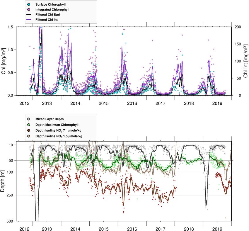
Le Traon et al.                                                                                                              Scientific Achievements of the NAOS Project

    FIGURE 1 | Over 1 million Argo profiles have been acquired since late 2012. Gray points: all Argo observations. Blue points: Argo-France observations. Red points:
    NAOS Core Argo observations.

for proposals1 . Their latest positions range from latitudes 55◦ S to                   scheme with Argos transmission (see André et al., 2020). Floats
83◦ N, reflecting France’s broad contribution to the international                      equipped with Iridium communication have a higher lifetime
Argo program in the global ocean.                                                       expectancy than Argos floats (due to more efficient satellite
    In terms of the total number of acquired Argo profiles, it is                       communication), with an expected number of 225 cycles before
worth noting that the deployment of the first NAOS standard                             the end of their battery life (>6 years). It is however too early to
Argo float coincided almost exactly with the one-millionth profile                      draw up at-sea statistics on the expected lifetime of the NAOS-
milestone achieved by the Argo program in late 2012. More                               generation Arvor floats. Indeed, none of the floats programmed
than 1 million Argo profiles later (the second-millionth profile                        on standard Argo cycles and equipped with Iridium has reached
milestone was proclaimed in late 2018), a quick glance at the                           the end of their battery life yet (the first deployments of NAOS
distribution of the 101 NAOS float observations shows that                              Iridium Arvor floats took place in mid-2016).
these floats have provided the community with more than 10000                               NAOS improvements have also led to the implementation
profiles, which represents 1% of all Argo observations and 10%                          of an Ice Sensing Algorithm (ISA) on the standard Arvor, thus
of the French contribution, the latter making up 10% of the                             allowing deployments in previously unsampled areas such as the
international contribution to Argo.                                                     Greenland Sea or the Baffin Bay, where some floats deployed have
    All NAOS core Argo floats are of the Arvor model                                    been able to survive under seasonal ice.
manufactured by nke instrumentation. Over the duration of                                   Ifremer, taking advantage of the expertise it has developed
the NAOS project, the Arvor model has benefited from several                            within NAOS, has also collaborated with the Euro-Argo ERIC
improvements (André et al., 2020), including hardware and                               to set up a suite of tools that allow at-sea monitoring of the
software upgrades. New mission capacities have been added and                           European Argo fleet and of the national Argo fleets. A first
Iridium communication (fitting 14 of the latest 2017 floats) has                        prototype was made available in 2017 and has since been
allowed a higher sampling of the water column as well as a more                         upgraded to provide Argo users with an advanced web-based
versatile configuration of floats through downlink transmission.                        monitoring tool2 .
This has proved to be a real asset on some deployments where it                             All NAOS floats have been distributed in the new Argo
has been possible to finely adjust the float mission to suit scientific                 format, V3.1, developed by Argo International, that allows the
needs at the outset (e.g., higher frequency cycling) before it has                      distribution of Iridium T&S floats as well as BGC and Deep
been set back to a standard Argo mission (10-day cycle) when                            floats. The processing chain developed within NAOS has been
the float has left the area of interest, usually after a few weeks. In                  upgraded and made available to the international community3 .
December 2019, almost half (45/101) of the 101 floats were still                        This chain also implements the Argo recommendations for BGC
active and most of the floats had reached their nominal number                          float processing in real time.
of 150–180 cycles (>4 years) for a typical 10-day Argo sampling
                                                                                        2
                                                                                            https://www.euro-argo.eu/Activities/Coordination/European-Fleet-Monitoring
1                                                                                       3
    http://www.mercator-ocean.fr/en/science-publications/gmmc/                              http://dx.doi.org/10.17882/45589

Frontiers in Marine Science | www.frontiersin.org                                   3                                           October 2020 | Volume 7 | Article 577408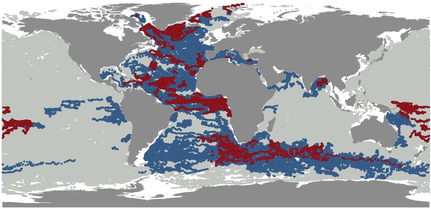
Le Traon et al.                                                                                              Scientific Achievements of the NAOS Project

    France’s ocean and climate research communities are strongly               puzzling large-scale circulation and a wide panel of contrasting
involved in Argo. Since the beginning of Argo, an original                     biogeochemical regimes, therefore making it an ideal playground
partnership between Mercator Ocean and Coriolis was set up                     for a BGC-Argo array pilot test.
to coordinate the interfaces between Argo-France, operational                      Moreover, the Mediterranean Sea has received renewed
oceanography and research communities. Over the past 10 years,                 interest from the scientific community at both French and
the French research community has contributed more than 400                    European levels (De Madron et al., 2013; Malanotte-Rizzoli et al.,
Argo-related internationally refereed publications. Data from                  2014). Scientific advancements in the last decades paved the way
NAOS floats feed these research activities thanks to longer                    for a completely new approach to Mediterranean physical and
time series and improved sampling. Such research covers a                      biogeochemical research, based on integrated observing systems,
broad range of topics including global sea-level variations (e.g.,             dedicated modeling efforts, and more importantly in this context,
Cazenave et al., 2014; Dieng et al., 2017), ocean-heat and                     the massive utilization of autonomous platforms. A dedicated 10-
salt-content variations (e.g., Von Schuckmann et al., 2016),                   year-long program (MERMEX), focusing on the Mediterranean
meridional circulation and deep convection (e.g., Piron et al.,                biogeochemical response to climate change, was funded (De
2017), tropical dynamics (e.g., Cravatte et al., 2017), large-scale            Madron et al., 2013), rallying together French and Mediterranean
circulation (e.g., Sévellec et al., 2017), eddy dynamics (e.g.,                (i.e., Italian, Greek, German, Turkish, Israeli) scientists.
Capuano et al., 2018), satellite validation (e.g., Boutin et al., 2018),           For both NAOS and MERMEX, one of the main scientific
modeling and data assimilation (e.g., Turpin et al., 2016; Artana              objectives was to identify and explain the interactions between
et al., 2018; Lellouche et al., 2018).                                         physical circulation and phytoplankton distribution, in both
                                                                               oligotrophic and blooming areas. The interactions between the
                                                                               two projects were extremely fruitful: on the one hand, the
BIOGEOCHEMICAL FLOATS IN THE                                                   NAOS project was nurtured by a stimulating environment for
MEDITERRANEAN SEA                                                              analyzing and interpreting BGC-Argo data; on the other hand,
                                                                               the MERMEX community benefited from novel technology
Rationale                                                                      providing physical-biogeochemical observations at a pan-
In the framework of NAOS, a specific and dedicated study                       Mediterranean scale and over the long term.
was conducted on the BGC-Argo component of Argo.                                   In 2011, 30 BGC-Argo floats (Leymarie et al., 2013)
A BGC-Argo float is an Argo profiling float equipped with                      were funded and acquired for the NAOS project. Their
biogeochemical sensors for chlorophyll, dissolved oxygen and                   implementation and deployment plans, profiling strategies and
nitrate concentrations, backscattering coefficients and irradiance.            performance statistics are described in D’Ortenzio et al. (2020)
At the beginning of NAOS (2010), the BGC-Argo network was                      and only briefly outlined here. Among the 30 acquired floats, 27
still in a preliminary phase. The technology related to the new                were deployed in two successive waves (in 2012 and 2015), 14
biogeochemical sensors was already stable, but most studies at                 have been recovered and 5 have been refurbished and redeployed,
the time were conducted on the basis of a very limited number                  giving a total of 32 deployments. Among the remaining 9
of floats (Gruber et al., 2007; Boss et al., 2008; Johnson et al.,             floats, 5 experienced critical damages and 4 are ready for future
2010). What was still lacking was a conclusive assessment of                   deployments. At the end of 2019, 9 floats were still operational
the simultaneous and multi-annual use of BGC-Argo floats as                    and 11 were definitively lost (Figure 2). The network gathered
a network, in anticipation of a global array. Furthermore, the                 more than 3900 profiles, with floats having a mean lifetime
quality control methodologies for Argo biogeochemical variables                of about 2.5 years. The deployment plan, formulated by a
(considered a fundamental prerequisite for implementing a                      working group of Mediterranean experts (D’Ortenzio et al.,
global array) were still under development.                                    2012), was established by considering satellite-derived ocean-
    For these reasons, one of the objectives of the NAOS BGC-                  color bioregionalization (D’Ortenzio and d’Alcala, 2009) as the
Argo component was to deploy and maintain a pilot array of                     main framework for selecting the areas in which to launch floats.
BGC-Argo floats at the scale of an ocean basin, and to contribute              Operating on the assumption that bioregions reflect the internal
to the development and implementation of an efficient data                     mechanisms of physical-biological interactions and that they can
stream for BGC-Argo parameters.                                                be considered homogenous for ocean dynamics (at least on a
    The Mediterranean Sea was selected to carry out the BGC-                   seasonal scale), the NAOS BGC-Argo floats were distributed on
Argo pilot test, on the basis of several scientific and logistic               the basis of 1–2 per bioregion. In agreement with the roadmap,
considerations. Despite its limited surface, the Mediterranean                 the floats’ sampling strategy (i.e., parking depth and sampling
Sea is characterized by complex ocean dynamics (Malanotte-                     frequency) was set to maintain the buoys in the bioregion
Rizzoli et al., 2014), composed of three thermohaline circulations.            of deployment for as long as possible. Numerical simulations
The three cells are forced by dense water formation, which                     (described in D’Ortenzio et al., 2020) indicated an optimal
occurs in specific and well localized areas. In these areas, the               parking depth of 1000 m and a sampling frequency modulated
resulting water mixing generates an upwelling of nutrients from                on the basis of the satellite phenology of each bioregion.
their deep reservoir, inducing weak-to-intense phytoplankton                       Since 2010, more than 20 peer-reviewed papers have been
spring blooms, which locally attenuates the strong and general                 published around NAOS BGC-Argo observations. They can
oligotrophy of the basin (Siokou-Frangou et al., 2010). Within                 roughly be classified into three main groups: (1) papers
a relatively limited area, the Mediterranean Sea thus shows                    contributing to the development of a global BGC-Argo network,

Frontiers in Marine Science | www.frontiersin.org                          4                                   October 2020 | Volume 7 | Article 577408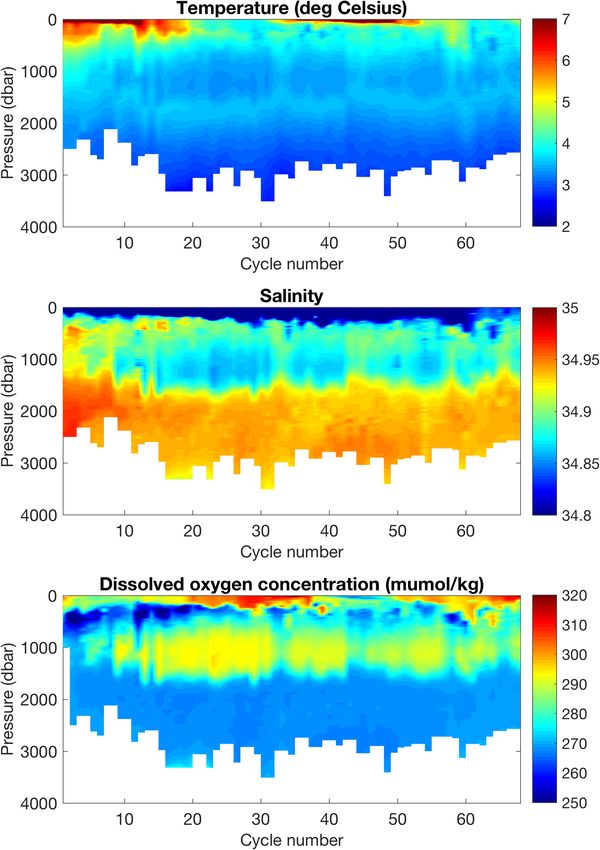
Le Traon et al.                                                                                                                   Scientific Achievements of the NAOS Project

    FIGURE 2 | Geographical locations of the BGC-Argo profiles of the NAOS Mediterranean network. White dots indicate the positions of the profiles, black points the
    locations of deployments. The last obtained profile is indicated in color: blue point for active floats, red for the dead, green for the recovered (see D’Ortenzio et al.,
    2020 for more details).

comprising algorithmic improvements and quality control issues;                             and deployment best practices for BGC-Argo floats. NAOS
(2) papers focusing on the functioning of the Mediterranean Sea,                            knowhow contributed to this synthesis, in particular with regard
for the most in collaboration with the MERMEX community;                                    to deployment protocols and also the acquisition and processing
(3) papers assessing the global characteristics of biogeochemical                           of ancillary data required for QC. In this way, Taillandier et al.
parameters, where NAOS data represented the Mediterranean                                   (2018) described the different protocols tested during the second
specificities. In the next section, a synthesis of achievements by                          wave of NAOS float deployments. They also proposed a protocol
the NAOS BGC-Argo network is given for each of these topics.                                for the recovery of BGC-Argo floats, emphasizing the role of
                                                                                            recoveries of still-operational floats (a relatively rare event,
Contribution to the Development of a                                                        although possible in the Mediterranean Sea) in QC methods and
Global BGC-Argo Array                                                                       the evaluation of sensor performance after long deployments. In
Technological advances have not played a substantial part in                                addition, Mignot et al. (2019) proposed a method for assessing
the BGC-Argo activity of NAOS, mainly because the platform                                  observational errors in BGC-Argo data, by combining in situ
(Provor-CTS4 equipped with bio-optical sensors) was already                                 observations and model simulations.
available at the beginning of the project (Leymarie et al., 2013).                             Novel Argo Observing System has also contributed to building
In the framework of the development of a global array, the                                  the use of BGC-Argo observations in ocean data assimilation
NAOS project contributed mostly to improvements in Quality                                  systems such as the ones developed as part of the Copernicus
Control (QC) methods. During the NAOS project, the BGC-Argo                                 Marine Service (Le Traon et al., 2019). Cossarini et al. (2019)
community organized regular and international meetings [for the                             have developed numerical methods to assimilate BGC-Argo data
most included in the Argo Data Management Team (ADMT)                                       (for the most part collected by NAOS floats) in a physical-
events4 ] to propose and discuss methods and organization of                                biogeochemical coupled modeling platform of the Mediterranean
BGC-Argo QC. NAOS participants were strongly involved in this                               Sea, whereas Terzić et al. (2019) have used the same dataset
activity, which is summarized in the technical reports produced                             to enhance representation of the propagation of sunlight in
by the BGC-Argo ADMT (Schmechtig et al., 2015; Johnson et al.,                              operational bio-optical models.
2018; Schmechtig et al., 2018).
   In parallel, specific analyses were conducted on the                                     Contribution to the Understanding of
performances of biogeochemical sensors. Roesler et al. (2017)
analyzed the calibration of the WetLab ECO-Puck fluorometers                                Mediterranean Biogeochemistry
(with which most BGC-Argo floats were equipped, to measure                                  As mentioned above, BGC-Argo activity was strongly tied
Chlorophyll concentration) to identify possible regional                                    to international efforts to improve characterization of
variability of the chlorophyll-to-fluorescence ratio. Authors                               Mediterranean physical-biogeochemical dynamics, as organized
highlighted the specific behaviors of Mediterranean waters,                                 under the MERMEX program (De Madron et al., 2011).
largely on the basis of NAOS BGC-Argo data. More recently,                                  Focusing on Mediterranean areas where deep convection and
Bittig et al. (2019) reviewed the latest advancements in QC                                 phytoplankton blooms are systematically observed, NAOS
                                                                                            represented the BGC-Argo component of MERMEX, furnishing
4
    http://www.argodatamgt.org                                                              unprecedented data to the scientific community.

Frontiers in Marine Science | www.frontiersin.org                                       5                                            October 2020 | Volume 7 | Article 577408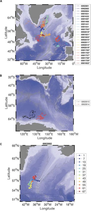
Le Traon et al.                                                                                         Scientific Achievements of the NAOS Project

   In the North Western Mediterranean Sea, 6 research cruises             and systematically sampled by BGC-Argo floats. The authors
were conducted during 2012–2013 and 6 NAOS floats were                    assessed the regional variability of backscattering coefficients,
deployed at the same time. The observational system was                   emphasizing the peculiar characteristics of the Mediterranean
complemented by two moorings and more than 30 glider                      Sea. NAOS BGC-Argo data were also used in the development of
missions (Estournel et al., 2016). In this context, the mechanisms        advanced statistical methods to augment the quantity and quality
generating and sustaining the deep convection of winter 2013              of information obtained from floats. Neural network algorithms
and the consequent phytoplankton bloom were exceptionally                 were developed and applied to enhance the spatial resolution
well elucidated (Testor et al., 2018), thanks to the combination          of biogeochemical fields (Sauzède et al., 2015) and to generate
of an adapted sampling strategy of BGC-Argo floats and                    parameters still unavailable directly (at least for the majority of
glider missions. The unique collection of biogeochemical                  Argo BGC floats), such as pH, pCO2 , and nitrate concentrations
observations from autonomous platforms (in particular, nutrient           (Sauzède et al., 2016, 2017; Bittig et al., 2018c).
and chlorophyll concentrations obtained from NAOS BGC-Argo
floats) over a complete annual cycle allowed us to identify the           The Step Forward: Interannual Variability
forcing factors controlling the intense phytoplankton bloom in            After 7 years of operations, the NAOS Mediterranean array
the North Western Mediterranean in 2013 (Mayot et al., 2017a).            has provided an exceptional dataset on the physical and
The observations of NAOS BGC-Argo floats provided data to                 biogeochemical dynamics of the basin. The collected data have
interpolate between the six oceanographic cruises conducted               already been intensively exploited and the NAOS Mediterranean
in the area, revealing an unprecedented picture of physical-              pilot array has been internationally acknowledged as a
biological interactions. Mayot et al. (2017b) extended the analysis       successful example of the potential of a global BGC-Argo
on a multi-annual scale, by also investigating the response               array (Biogeochemical-Argo Planning Group, 2016). The
of phytoplankton communities to the variable forcing factors.             network is still operational and its data offer further avenues
Furthermore, BGC-Argo observations were used to initialize and            of research yet to be explored. For example, the interannual
validate physical-biogeochemical coupled models in the North              variability of Mediterranean biogeochemical cycles – clearly one
Western Mediterranean region. Models were shown to soundly                of the potential applications of the existing BGC-Argo network –
reproduce the biogeochemical cycles (Kessouri et al., 2017, 2018).        calls for investigation.
   In a pan-Mediterranean context, NAOS BGC-Argo                              A first attempt to analyze interannual variability of NAOS
float datasets have been analyzed to identify large-scale                 BGC-Argo data in the Mediterranean is presented below. We
biogeochemical characteristics of the basin, which were generally         focus specifically on the North Western Mediterranean region,
poorly assessed because of a critical lack of pertinent data. De          on which several papers have been published using NAOS BGC-
Fommervault et al. (2015a) thus investigated the large-scale              Argo data (see above), and for which the density of collected
distribution of nitrate in the Mediterranean, by comparing                profiles is particularly high.
time-series of BGC-Argo floats along an East–West gradient.                   In the North Western Mediterranean region, additional BGC-
They also characterized the seasonal evolution of nitracline              Argo floats on top of the NAOS fleet have been deployed
in the Mediterranean’s four main sub-basins, thanks to the                under the responsibility of the Argo-France (GMMC) and Argo-
unprecedented temporal resolution of the database of nitrate              Italy programs. These floats have the same sensor configuration
profiles collected by the first wave of NAOS BGC-Argo floats.             as NAOS BGC floats (although most of them have no NO3
By systematically analyzing chlorophyll concentration profiles            sensor). Corresponding datasets were processed using the same
obtained from the NAOS BGC-Argo array, Lavigne et al.                     methods as for the NAOS floats. When NAOS data are combined
(2015) and Barbieux et al. (2019) assessed the spatio-temporal            with the other float data, the number of collected profiles over
distribution of Deep Chlorophyll Maxima (DCM), clarifying its             the period 2013–2019 comes to 1472, with 545 NO3 profiles
seasonal variability in particular.                                       (see map in Figure 3).
                                                                              The merging of all the data from the North Western
                                                                          Mediterranean region (the so-called bloom bioregion defined by
Contribution to Assessments of Global                                     Mayot et al. (2017a)) generated time series of Mixed Layer Depth
Characteristics of Biogeochemical                                         (MLD, computed by BGC-Argo T/S data following D’Ortenzio
Parameters                                                                et al., 2012) and of Chlorophyll concentration in the 0-300
Although limited to the Mediterranean Sea, NAOS BGC-                      m layer and the surface (Figures 3, 4). Time series of the
Argo data have been repeatedly used in studies aiming                     depth of isolines of NO3 concentrations were also produced.
to analyze global characteristics of biogeochemical fields. In            We selected the isoline of 7 µmole/kg as a proxy of the deep
this way, Organelli et al. (2017) revisited global ocean bio-             stock, and the isoline of 1.5 µmole/kg as a proxy of the nutrient-
optical behaviors, on the basis of the unique collection of               depleted layer. The well-known recurrent phytoplankton blooms
irradiance profiles obtained by BGC-Argo floats. Thanks to                (Figures 3, 4, upper panel) are well observed during the winter-
NAOS observations, a specific section of the Mediterranean,               to-spring transition (Mayot et al., 2017b). Interannual variability
characterized by a well-known bio-optical anomaly (Volpe et al.,          is particularly evident in the intensity of blooming events,
2007), was included in this study. Similarly, Barbieux et al.             with a decreasing magnitude for the absolute maximum of the
(2018) characterized the global ocean variability of backscattering       surface and the integrated (between 0 and 300 m) chlorophyll
coefficients, generally used as a proxy of organic carbon                 from 2012 to 2019.

Frontiers in Marine Science | www.frontiersin.org                     6                                    October 2020 | Volume 7 | Article 577408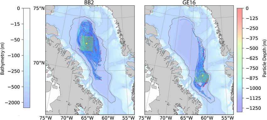
Le Traon et al.                                                                                                          Scientific Achievements of the NAOS Project

  FIGURE 3 | Upper panel: temporal evolution of chlorophyll concentration. Lower panel: temporal evolution of NO3 concentrations in the first 500 m. The isoline of
  7 micromole/kg is indicated in black. On the map, the positions of the profiles of NAOS (red points), GMMC (blue) and Argo-Italy (green) are indicated.

Frontiers in Marine Science | www.frontiersin.org                                7                                          October 2020 | Volume 7 | Article 577408
Le Traon et al.                                                                                                             Scientific Achievements of the NAOS Project

  FIGURE 4 | Upper panel: time series of surface (light blue) and integrated (0–300 m, violet) chlorophyll concentrations. Lines show a moving average for the profile
  estimations. Lower panel: times series of MLD (gray points), DCM depths (green points) and NO3 isoline depths for 7 (brown) and 1.5 (light brown) micromole/kg.
  Lines show temporal moving averages.

   The intensity of mixing is also highly variable interannually                       series in terms of magnitude – is paralleled by a MLD not
(Figure 4, lower panel). In winter 2012–2013, an event                                 exceeding 100 m.
of MLD greater than 700 m was captured (Testor et al.,                                    The vertical distribution of NO3 and its time evolution
2018; Prieur et al., 2020). A MLD deeper than 400 m was                                closely follow the water-column characteristics, showing that
also observed during winter 2018–2019. For the other years,                            nutrient stocks are relatively shallow in the area, and that
the MLD was generally shallower, with mean values rarely                               injection of nitrate in the surface layers is possible even in
exceeding 100 m. MLDs greater than 400 m, as observed in                               the case of relatively low MLD deepening. Spring surface NO3
the 2012–2013 and 2018–2019 winters, can provoke different                             concentrations observed by BGC-Argo in the North Western
and contrasting responses: an intense bloom in 2012–2013                               Mediterranean are generally not zero and were unusually high in
and a weak episode of chlorophyll increase in 2018–2019.                               2013, 2014, and 2015 (and in 2018, although less clearly because
Following on from these contrasts, the bloom observed in                               of missing data). Consequently, and as expected, phytoplankton
2013–2014 period – the second most important event in the                              concentrations during the winter-to-spring transition were

Frontiers in Marine Science | www.frontiersin.org                                  8                                           October 2020 | Volume 7 | Article 577408
Le Traon et al.                                                                                          Scientific Achievements of the NAOS Project

generally high (i.e., showing blooming conditions). The injection        the surface and DCM depths remain shallow for most of the
of NO3 in the surface and the associated phytoplankton growth            following spring and summer.
do not seem, however, to be directly dependent on the mixing
intensity (i.e., the maximum depth reached by the mixed layer).          Conclusion
For example, an increase of NO3 in the surface was observed in           The NAOS BGC-Argo experiment in the Mediterranean Sea
2015 or in 2016, although the MLD rarely exceeded a depth of             was highly successful, from technological, logistical and scientific
200 m in these years.                                                    points of view. Technologically, platforms and sensors were
    On the other hand, the intensity of winter mixing appears            operationally tested on long-term deployments: very few sensors
to impact on NO3 concentrations in sub-surface layers for the            experienced failure and float statistics are close to those for the
rest of the following year. Excluding the periods characterized          global BGC-Argo array (D’Ortenzio et al., 2020), which is an
by NO3 increase following MLD deepening, the surface waters              excellent result in a marginal sea. The NAOS fleet met the initial
are completely depleted of NO3 for most of the year. Generally,          requirement of continuous BGC monitoring of a basin-scale area
the depth of the depleted layer is approximately 100 m for               for 7 years, with an average float lifetime of 2.5 years. Logistically,
all the time series, except during the winter-to-spring period           NAOS tested different ways to develop and maintain the network,
when the vertical distribution of NO3 in the first 500 m appears         acquiring important knowhow for the construction of a global
anomalous and an uplift of the 1.5 NO3 isoline is observed               BGC-Argo array. The high number of float recoveries led to
(i.e., 75–80 m). During these periods, the NO3 concentrations            substantial reductions in network costs, allowing a third wave of
characterizing the deep stock (i.e., approx. 7 micromole/kg for          deployments that was not planned at the beginning of the project.
the NW Mediterranean) are observed at shallower depths than              Recoveries data as well as ancillary information collected at
in other years. In other words, the periods following the strong         recoveries also provided unique information on data quality and
mixing events in the winters of 2013 and 2019 are characterized          sensor performance (e.g., Mignot et al., 2019). Recoveries were
by a subsurface distribution of NO3 different from all the               certainly facilitated by the reduced size of the Mediterranean; they
other sampled years.                                                     required, in addition, organization, logistics and an improved
    As already postulated by D’Ortenzio et al. (2014) (through           float technology. D’Ortenzio et al. (2020) provides a wider
analysis of NO3 profiling floats during the year 2012–2013),             discussion on the benefits and the disadvantages of the recoveries.
deep mixing events are therefore not critical for inducing               Part of the experiment’s success is also due to the strong
phytoplankton blooms at the surface, as NO3 concentrations at            collaboration with Med-Argo (Poulain et al., 2007), in charge
the subsurface are always relatively high. Even relatively shallow       of coordinating Mediterranean Argo activity. Scientifically,
MLDs allow upper layers to be refueled with nutrients. In this           close collaboration with the international community of the
context, analysis of the NAOS interannual time series offers             MERMEX project generated an extremely fruitful synergy,
another element. Deep mixing events (as in the winters of 2013           which resulted in an high number of publications about the
and 2019) induce a dramatic redistribution of NO3 throughout             physical-biogeochemical dynamics of the Mediterranean Sea (in
the water column. The main consequence is the presence of NO3            addition to the papers already cited, see for example Lavigne et al.,
concentrations at depths shallower than those observed during            2013; Prieur et al., 2014; De Fommervault et al., 2015b; Houpert
the years without deep mixing. This anomalous uplift of NO3              et al., 2016; Bosse et al., 2017; Xing et al., 2017). Additionally,
following a deep MLD event seems to have an impact on the                NAOS BGC-Argo activity contributed to the assessment of
characteristics of Deep Chlorophyll Maximum (DCM, Figure 4).             operational QC methods, in the international framework of the
For most years, the DCM deepens progressively after the MLD              ADMT. Interactions with operational centers were not limited
annual maxima, roughly following the 1.5 micromole/kg isoline            to the QC data stream. Important collaborations with physical-
(as already recognized by Barbieux et al., 2019). The DCM is             biogeochemical operational modelers recurred throughout the
finally destroyed when the MLD reaches its layer, during the             NAOS lifetime. This activity was conducted in collaboration with
following autumn. Anomalously, in the period following the 2013          the Italian OGS group (Cossarini et al., 2019; Terzić et al., 2019)
bloom, and up to fall 2014, the depth of the DCM was quite               and with Mercator Ocean International, in particular to define
stable with the DCM intensity (i.e., chlorophyll values at maxima)       metrics for data-model validation.
decreasing only weakly over time.
    Assuming the spatial and temporal representativeness of
the network (see D’Ortenzio et al., 2020, for a comprehensive
                                                                         BIOGEOCHEMICAL FLOATS IN THE
discussion of this issue), interannual analysis of BGC-Argo
profiles in the North Western Mediterranean indicates that               ARCTIC OCEAN
MLD intensity is not the primary factor controlling spring-
bloom intensity. The area’s large-scale conditions (Prieur et al.,       The Scientific Context of a Pilot Study in
2020) induce a sufficiently significant uplift of NO3 isolines to        Baffin Bay
sustain phytoplankton growth, even in the case of relatively             Climate change has triggered fundamental modifications to
weak mixing. However, the complete vertical redistribution               marine biotopes in the Arctic Ocean. For instance, the decrease
of NO3 that occurs after deep-mixing events modifies the                 in the extent of the icepack during summer has led to a 30%
characteristics of the DCM for the rest of the year: conditions          increase in pan-Arctic primary production (PP) over the past two
more favorable for phytoplankton growth develop close to                 decades (Arrigo and Van Dijken, 2015). One prominent element

Frontiers in Marine Science | www.frontiersin.org                    9                                      October 2020 | Volume 7 | Article 577408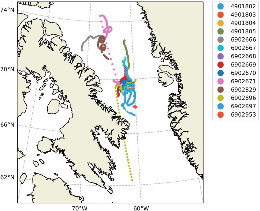
Le Traon et al.                                                                                                      Scientific Achievements of the NAOS Project

of PP in the Arctic Ocean is the phytoplankton spring bloom                surface only in favorable ice-free conditions (see details in André
(PSB) that develops around the ice edge, both under sea ice and            et al., 2020). When not surfacing, the Pro-Ice stores data in a non-
in open waters: accounting for much of the annual PP, this PSB             volatile memory until satellite communications are resumed.
is generally associated with both large energy transfer to higher
trophic levels and export of carbon at depth (e.g., Randelhoff             Strategy for Deployments in the Icy Waters of Baffin
et al., 2019). To determine the fate of the PSB and related                Bay
Arctic ecosystem features in a context of profound changes,                The deployment of floats in Baffin Bay (BB) implied navigational
it is necessary to develop a mechanistic understanding of this             challenges in terms of bathymetry, ice coverage and circulation.
recurrent event, i.e., how exactly it is controlled by the physical        Possible trajectories of floats were simulated to optimize the
and chemical properties of sea ice and the upper water column.             localization of the deployment areas and to ensure as much
To study the dynamics of PSBs, year-long high-frequency time               as possible that floats stayed in the Baffin Bay throughout
series of phytoplankton phenology and its drivers are required.            their lifetimes. The cyclonic circulation in the area and the
In the AO, BGC-Argo floats are a complementary tool to                     Baffin Current tend to eject any drifting object (including
remote sensing and oceanographic cruises, useful for studying              icebergs) from Baffin Bay along the west side of Davis Strait.
the dynamics of the PSB as controlled by sea-ice dynamics,                 Simulations of trajectories were achieved using the Ariane
vertical mixing, light and nutrients. The development of a new             tool (Blanke et al., 19996 ) that permits offline calculation of
generation of floats (Pro-Ice) for operation in icy waters was             streamlines from model velocity fields. The velocity fields on
carried out as part of the NAOS project. The fleet of Pro-Ice              a 1/4◦ grid came from the Canadian CONCEPTS Global Ice-
floats was co-funded by NAOS and the Canadian Foundation for               Ocean Prediction System (GIOPS, Smith et al., 2016). Based on
Innovation (CFI). The first deployments of BGC-Argo floats in              these simulated trajectories (Figure 5), two main dropping zones
Baffin Bay debuted in 2016. They were performed as part of a               that avoided ultimate ejection were selected with a bathymetry
NAOS pilot experiment, within the programmatic framework of                largely above 1000 m: the BB2 ArcticNet station (72◦ 450 060N
the Green Edge research project5 . The main objectives were to             67◦ 0W) at the very center of the Baffin Bay cyclonic gyre
study Arctic PSBs.                                                         and southeast of the Baffin Bay (69◦ 30N 61◦ W) within the
                                                                           2016 Green Edge cruise area (GE; Randelhoff et al., 2019).
Materials and Methods                                                      These zones are presented in Figure 6. Trajectory simulations
Features of the Pro-Ice Floats                                             were combined with observations from ice charts (climatology
For the Arctic pilot study, 21 Pro-Ice floats, equipped with a             and real-time charts) for safe deployments and navigation.
biogeochemical payload and adapted to navigate in icy waters,              MODIS chlorophyll a concentration images were used as well
were prepared for deployment in Baffin Bay. Pro-Ice floats are             for the choice of location and deployment period relevant to
manufactured by the French company nke instrumentation using               the ice-edge PSB. Mid-July was the most favorable period for
third-party electronics and were developed in the framework of             the deployments.
NAOS (see André et al., 2020). They belong to the Provor-CTS5                  In terms of float programming, two controller boards (a
class, an extension of the Provor-CTS4 (Leymarie et al., 2018;             piloting board and a science board for the sensors) make the
André et al., 2020; D’Ortenzio et al., 2020), and have been adapted        Pro-Ice quite flexible (see André et al., 2020). These can be
to operate in ice-covered seas.                                            programmed both in real time by Iridium communication and
   Pro-Ice BGC floats are equipped with a Sea-Bird SBE41                   in advance by means of a script file, based on the dating of events.
CTD (conductivity-temperature-depth) unit, an Aanderaa 4330                The dates of activation of the ISA (Ice Sensing Algorithm) for
oxygen optode mounted on a 30-cm stalk, a WET Labs ECO                     ice detection were scheduled by this script. The ISA threshold
Triplet for the observation of chlorophyll a fluorescence, CDOM            used is shown in Supplementary Table S2. In addition to this,
(colored dissolved organic matter) fluorescence, and particle              upward winter profiles were limited to 15 m under ice cover as
backscattering at 700 nm (bbp ), as well as a Satlantic SUNA V2            a conservative measure. As described in André et al. (2020), the
sensor for nitrate. They are also fitted with a Satlantic OCR-             schedule (time of year), ISA and altimeter results were combined
504 radiometer measuring irradiance at three wavelengths (412,             by the science board to make a surfacing decision. We also
490, 555 nm) and quantum irradiance over the photosynthetically            developed and tested an optical ice-detection system to improve
available radiation (PAR) range (400–700 nm). This payload                 the reliability of this decision (Lagunas et al., 2018).
gathers five of the six core Biogeochemical Argo variables:                    The time scheduling of float operation, written in the script
oxygen, nitrate, chlorophyll a, suspended particles, downwelling           file, evolved slightly over the period from 2016 to 2019 on the
irradiance and pH.                                                         basis of experience feedback. For floats navigating before fall
   An ice-covered ocean presents a real challenge for Argo                 2018, one profile per day was programmed until November
floats that must surface for geo-localization and to use satellite         15th, before switching to a 28-day cycle until August 1st, then
networks for data transmission and command reception (Riser                reverting to a 1-day cycle. After fall 2018, temporal resolution was
et al., 2016). Therefore, technical adjustments are required to            increased during the winter and the spring months, to sample all
make the floats as operational as possible in the Arctic Ocean,            events under ice. These dates were set in the script file according
in particular with essential ice-detection systems to allow them to        to ice-concentration climatology. However, especially during

5                                                                          6
    http://www.greenedgeproject.info/                                          http://www.univ-brest.fr/lpo/ariane

Frontiers in Marine Science | www.frontiersin.org                     10                                               October 2020 | Volume 7 | Article 577408
Le Traon et al. Scientific Achievements of the NAOS Project
FIGURE 5 | Simulated Lagrangian particle tracking results for float deployments around BB2 (left) and GE2016 (right) zones using Ariane and GIOPS 1/4◦ current
fields (see text). The 1000 m bathymetry contour is shown as a thicker black line. Particles were released at green circles; their final locations after 353 days of
simulation shown as red circles. Final Pro-Ice drop zones (yellow crosses) were chosen to minimize the possibility of ejection from Baffin Bay.
fall, a daily survey of satellite ice charts (Radarsat, Sentinel- Implementation and Float Performance
1, AMSR2) and SST charts (Sea Surface Temperature) helped Through funding from the NAOS project and the CFI, 21
make decisions to switch to the winter mode earlier than mid- Pro-Ice floats were purchased. Float deployment began in
November when necessary. 2016 during the Green Edge cruise onboard CCGS Amundsen,
with 4 Pro-Ice deployed in the GE area (see Figure 6). All
four performed a hundred cycles and disappeared during the
following winter. A fifth float was deployed in the Labrador
Sea (André et al., 2020). During the 2017 Amundsen cruise,
4 Pro-Ice floats were deployed in the GE area and 3 in the
BB2 area. Four of them were prematurely lost, two of them
cycled beyond one winter (takapm012b: 388 days, 124 profiles;
takapm017b: 260 days, 106 profiles), and one of them cycled
beyond two winters (takapm016b: 736 days, 185 profiles). In
summer 2018, two more floats deployed from the Amundsen
acquired data beyond one winter (takapm020b: 452 days, 186
profiles; takapm011b: 318 days, 133 profiles). They benefited
from technical improvements, notably for the management
of grounding (see below) and an upgraded ISA. Two floats
were deployed in the summer of 2019: one is still active,
the second suffered a water leakage and may be recovered.
Supplementary Table S2 presents the performance of the floats
that have been deployed so far. Our experience in the Baffin
Bay shows a possible life expectancy close to 200 profiles
descending to 1000 m, as described in the NAOS companion
paper (André et al., 2020).
Whenever possible, floats were recovered by the C.C.G.S.
Amundsen scientific crew (2 floats in summer 2018) and by the
C.C.G.S. Louis St Laurent scientific crew (2 floats in fall 2019) for
refitting and redeployment.
More than 1900 profiles have been collected so far by the
Pro-Ice floats in the study area (Supplementary Table S2). The
FIGURE 6 | The Argo float symbols indicate the 2 dropping areas (BB2 and number of profiles acquired per float from 2016 through 2019
GE). Dots represent stations of the GE 2016 oceanographic cruise (Randelhoff
et al., 2019).
is shown in Figure 7, while the number of profiles per sensor
package is described in Figure 8.
Frontiers in Marine Science | www.frontiersin.org 11 October 2020 | Volume 7 | Article 577408Le Traon et al. Scientific Achievements of the NAOS Project FIGURE 7 | The number of profiles per Pro-Ice float (2016–2019). All deployments took place in two main dropping zones in Baffin Bay: the BB2 ArcticNet station (72◦ 45’060N 67◦ 0W) at the very center of the cyclonic gyre and in southeast region (69◦ 30N 61◦ W). FIGURE 8 | Number of profiles collected each month from 2016 through 2019. Colors indicate the sensor package. The trajectories of the floats deployed at the partial or complete ice cover restricts access to the sea 2 dropping areas (BB2 and GE) are presented in surface, denying access to satellite-based positioning and Figure 9. Generally, they are consistent with the Ariane telemetry services. Trajectories of floats are therefore simulations shown in Figure 5. At high latitudes, unknown during winter. Frontiers in Marine Science | www.frontiersin.org 12 October 2020 | Volume 7 | Article 577408
Le Traon et al. Scientific Achievements of the NAOS Project
FIGURE 9 | Trajectories of floats collected from 2016-07-09 to 2019-10-12. Missing (under-ice) GPS fixes have been linearly interpolated as a visual aid.
For its emergence, a float needs to transfer oil to increase Parsons et al. (1984). In addition, samples were taken for High
its buoyancy. In Polar regions, this amount of oil is particularly Performance Liquid Chromatography (HPLC) measurements
substantial to cope with seasonal desalted layers at the surface due of chlorophyll a concentration, performed by the SAPIGH7
to sea-ice melt during spring and early summer. Our experience national analytical service (Ras et al., 2008). Samples were taken
in the Baffin Bay shows that this difficulty is particularly well at 10 different levels in the water column to evaluate CDOM
managed by the Provor-type Pro-Ice floats. concentration onboard using an Ultrapath spectrophotometer,
The loss of Pro-Ice floats at the beginning of the campaign as described by Bricaud et al. (2010). Sampling at 24 depths
remains unexplained. Nevertheless, some incidents in 2017 was performed for nitrate analyses using a standard colorimetric
revealed a relationship between grounding events and losses method (Grasshoff et al., 1999).
in certain circumstances. The grounding strategy therefore had The sampling resolution of the sensors is detailed in
to be modified, as described in André et al. (2020), and is Supplementary Table S1. Prior to deployment, data from RemA
now correctly managed thanks to the firmware implemented in sensors (OCR504 and ECO triplet) were collected in dark
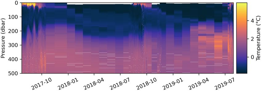
mid-2018. Pro-Ice (takapm016b/WMO 6902671) was remotely conditions to evaluate their offset drift since factory calibration.
upgraded in fall 2018, and was consequently given a second A night profile was programmed as an in situ check of this offset
WMO number (6902953). It captured a two-year time-series as down to 1000 m to cover a relatively large temperature range,
shown in Figure 10. which helped to determine the response of OCR to temperature
(Bittig et al., 2019). Oxygen was measured by the optode with an
individual factory multi-point calibration, as recommended by
Data Management and Qualification Bittig et al. (2018a). Oxygen data were systematically collected in
A 0–1000 m CTD-rosette cast was systematically performed air in a wet state over a 30-min period in order to evaluate the gain
right after each deployment of one or multiple floats. The correction before deployment. The optodes on Pro-Ice floats are
CTD (Seabird SBE911+) was equipped with double temperature, mounted on a 30-cm stalk and twenty O2 in-air measurements
conductivity, and oxygen sensors. These sensors were calibrated were programmed during each surfacing of the float (Bittig and
before and after the cruises. Seawater was also collected to Körtzinger, 2015; Johnson et al., 2017; Bittig et al., 2018b).
evaluate and characterize calibration errors of the biogeochemical Real-time quality control (RTQC) of all raw Pro-Ice data was
sensors (Taillandier et al., 2018; Mignot et al., 2019). Chl-a conducted by the Coriolis data center following the standard
measurements were taken at 10 levels in the 100 m upper layer procedures of the Argo program (Schmechtig et al., 2016).
for shipboard fluorometric analyses using a Turner Designs
fluorometer 10-AU and following the acidification method of 7
http://www.sapigh.obs-vlfr.fr/
Frontiers in Marine Science | www.frontiersin.org 13 October 2020 | Volume 7 | Article 577408Le Traon et al. Scientific Achievements of the NAOS Project
FIGURE 10 | Two-year temperature time series captured by float “takapm016b” (WMOs 6902671 and 6902953, whose change in WMO in summer 2018 was due
to a firmware update).
Delayed-Mode Quality Control (DMQC) on O2, NO3, and FChla Conclusions on the Use of BGC-Argo
was implemented offline by Takuvik. A detailed description of Floats in the Arctic Ocean
DMQC procedures is given in the Supplementary Materials
The Arctic Ocean is an important component of the Earth
where Supplementary Table 3 gathers the correction coefficients.
system, especially in the current context of global warming.
Yet Arctic amplification and all its related impacts, notably
on biogeochemical cycles and ecosystems, remain poorly
Scientific Results understood, mostly because they are poorly documented.
Floats have now been deployed in Baffin Bay during four Collection of data in the ice-covered Arctic Ocean still
successive summers (2016-19). After correcting a firmware remains very limited because of difficult access to this extreme
setback that led to grounded floats during the first year, annual environment (Smith et al., 2019). Extending the BGC-Argo fleet
time series have been collected for 2 years in a row at the to this region could significantly help fill this gap. The work
time of writing. achieved in Baffin Bay by NAOS has contributed to this goal.
As sea ice, along with adverse winter weather, is a major The three main approaches for collecting long high-frequency
impediment to the exploration and surveillance of Arctic regions, time series in the Arctic Ocean are moorings, ice-tethered
these year-round time series have presented unprecedented platforms (ITPs) and free-drifting profiling floats. Mooring
opportunities to study seasonal dynamics of phytoplanktonic provide Eulerian observations at a known position in delayed
ecosystems. So far, two studies have been conducted on mode. ITPs are mostly dedicated to physical oceanography,
phytoplankton phenology, i.e., its seasonal abundance patterns. and provide observations from given drifting ice floes (neither
We have investigated how vertical mixing strengthens and Eulerian nor Lagrangian) that can be located and uploaded
PAR irradiance diminishes during early fall, and how these readily in real time. As for Argo floats, up to now, only a few
two major constraints give rise to phytoplankton fall blooms. have been deployed in icy polar oceans, and even fewer BGC-
Randelhoff et al. (2020b) have analyzed an entire annual cycle Argo floats. These offer a complement to moorings and ITPs by
of phytoplankton biomass, hydrography, irradiance, and sea providing, very often, Lagrangian observations at depth in real
ice cover to decipher the environmental factors controlling the time (ice-free) or delayed (ice-covered) mode. The expanding
spring-bloom initiation. suite of sensors carried by BGC-Argo floats allows the study of
Given the extensive bio-optical sensor suite installed on the transient processes and seasonal cycles in biogeochemical fluxes
Pro-Ice floats, we expect a host of other future applications and marine ecosystems, as illustrated by the data obtained in
such as investigations into water-mass dynamics, vertical carbon Baffin Bay. This approach offers considerable potential, as shown
export, and ocean optics. For example, Randelhoff et al. (2020a) by our scientific results, but some major technological challenges
have used the annual cycle of upper-ocean nitrate concentrations remain to be tackled before BGC-Argo floats can be deployed in
to study the vertical upward flux of nitrate in Baffin Bay, as larger numbers in ice-covered sectors of the Arctic and Antarctic
shown in Figure 11. By considering successive vertical profiles of Oceans. Due to recent marked increases in the size of the seasonal
nitrate concentration during winter, they constrained the nitrate ice zone and the duration of the ice-free season (Arrigo and Van
increase that is due to entrainment from below the mixed layer. Dijken, 2015), further expected to grow significantly (Notz and
The winter mixed layers were up to 60 m deep – relatively Stroeve, 2018; Lebrun et al., 2019), the use of BGC-Argo floats
deep by Arctic standards but within the range observed in other for real-time operations has and will become more and more
Atlantic-influenced parts of the Arctic Ocean – and so the vertical feasible in Arctic seas. On the other hand, their use under sea ice
turbulent nitrate supply in Baffin Bay was one of highest observed will require appropriate deployment strategies. In a recent study,
during the Arctic winter. Nguyen et al. (2020) showed that error in Argo’s geo-positioned
Frontiers in Marine Science | www.frontiersin.org 14 October 2020 | Volume 7 | Article 577408You can also read