Record linkage and mapping data for UK geographies - Anna Palczewska - Leeds ...
←
→
Page content transcription
If your browser does not render page correctly, please read the page content below

Record linkage and mapping data
      for UK geographies

             Anna Palczewska

      QuantiCode’s Technical Report, 13 Sep 2016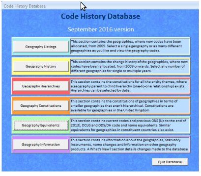
Abstract

    The QuantiCode report provides technical details on a process of record linkage and
mapping data for UK geographies. The reader can find here a brief description of methods
and algorithms used in each step of record linkage: data standardisations, comparison,
classification and evaluation, basing information on the privacy-preserving linkage. This
report provides the description of UK statistical geographies, their hierarchies and re-
lationships. This document includes also a short information about methods for data
integration from various geographies: lookup tables and GIS.
    The QuantiCode project is developing novel data mining and visualization tools and
techniques, which will transform people’s ability to analyse quantitative and coded lon-
gitudinal data. Such data are common in sectors such as health (e.g., electronic health
records), local government (e.g., service provision) and retail (e.g., product sales). The
project is funded by the Engineering and Physical Sciences Research Council (grant ref.
EPN0139801) and, through the Leeds Institute for Data Analytics (LIDA), supported by
the Medical Research Council (ESL0118911) and Economic and Social Research Council
(ESL0118911).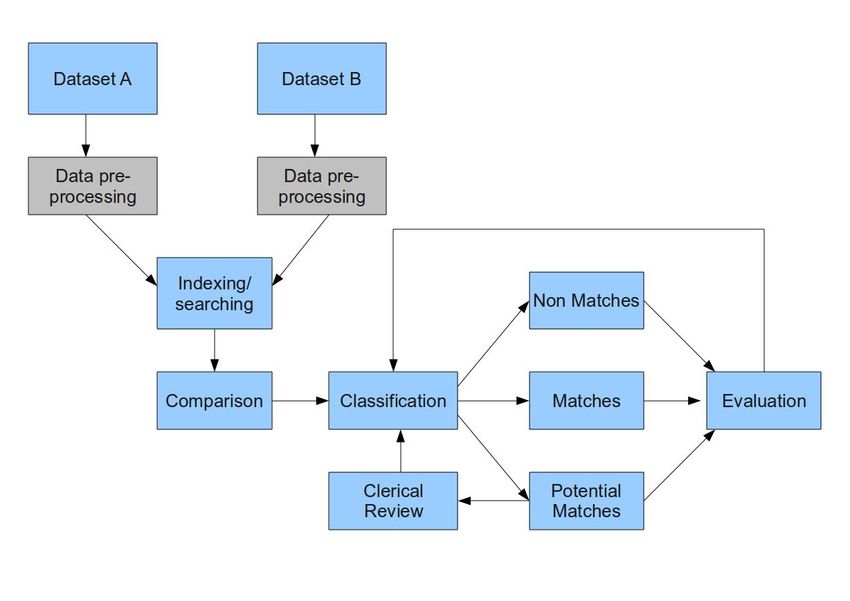
Contents

1 Record linkage                                                                                                   2
  1.1 Introduction to record linkage . . . . . . . . . .   .   .   .   .   .   .   .   .   .   .   .   .   .   .   2
  1.2 Record linkage process . . . . . . . . . . . . . .   .   .   .   .   .   .   .   .   .   .   .   .   .   .   3
      1.2.1 Data cleaning standardisation . . . . . .      .   .   .   .   .   .   .   .   .   .   .   .   .   .   3
      1.2.2 Blocking, indexing and comparison . . .        .   .   .   .   .   .   .   .   .   .   .   .   .   .   5
      1.2.3 Classification - general linkage techniques    .   .   .   .   .   .   .   .   .   .   .   .   .   .   6
      1.2.4 Record linkage evaluation . . . . . . . .      .   .   .   .   .   .   .   .   .   .   .   .   .   .   6
  1.3 Advanced record linkage techniques . . . . . . .     .   .   .   .   .   .   .   .   .   .   .   .   .   .   7
  1.4 Privacy-preserving record linkage . . . . . . . .    .   .   .   .   .   .   .   .   .   .   .   .   .   .   8
  1.5 Open source linkage software . . . . . . . . . . .   .   .   .   .   .   .   .   .   .   .   .   .   .   .   9

2 Linkage and mapping geographically referenced data                                                               11
  2.1 UK geographies . . . . . . . . . . . . . . . . . . . . . .           .   .   .   .   .   .   .   .   .   .   11
      2.1.1 Postal geography . . . . . . . . . . . . . . . . .             .   .   .   .   .   .   .   .   .   .   11
      2.1.2 Census geography . . . . . . . . . . . . . . . . .             .   .   .   .   .   .   .   .   .   .   12
      2.1.3 Administrative geography . . . . . . . . . . . .               .   .   .   .   .   .   .   .   .   .   13
      2.1.4 Electoral geography . . . . . . . . . . . . . . . .            .   .   .   .   .   .   .   .   .   .   15
      2.1.5 English health geography . . . . . . . . . . . . .             .   .   .   .   .   .   .   .   .   .   16
      2.1.6 Other geographies . . . . . . . . . . . . . . . . .            .   .   .   .   .   .   .   .   .   .   18
  2.2 Linking geographically referenced data . . . . . . . . .             .   .   .   .   .   .   .   .   .   .   18
      2.2.1 ONS files . . . . . . . . . . . . . . . . . . . . .            .   .   .   .   .   .   .   .   .   .   19
      2.2.2 Linkage using GIS . . . . . . . . . . . . . . . .              .   .   .   .   .   .   .   .   .   .   23

Glossary                                                                                                           25

                                           1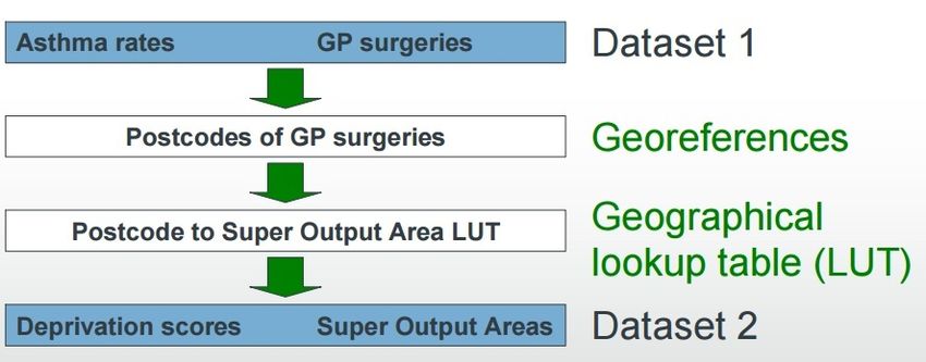
Chapter 1

Record linkage

Record linkage is a process that matches records representing the same instance or entity
from one or more databases. In this chapter the main terminology for record linkage,
the whole process of record linkage and new computational methods for reducing the
scalability and privacy presenting problems are described. There is also a list of open
source software for record linkage. The list is not exhaustive but the selected software
demonstrate variability in terms of functionality.

1.1      Introduction to record linkage
Large amounts of data are generated and collected every day by various organisations,
public and private institutions, researchers and individuals. Examples of such data come
from shopping transactions, social media, phone records, electronic records for health
or census, etc. Integration and analysis of these data can bring benefits for various
organisations leading to a better understanding of society. Moreover, linking different
sources we can improve data quality, enrich data with additional information, and allow
for more sophisticated analysis. At the same time, it is a challenging process due to the
lack of unique identifiers, a size of data, quality (typographical errors, variations, different
coding), different formats, privacy and confidentiality.
    Record linkage is a process of matching records that represent the same instance or
entity from one or more databases [1]. In many domains the linkage process is often known
as data matching, entity resolution, object identification, identify uncertainty, merge-
purge process (for removing duplicates in files). The process of linkage records from one
database is also often called duplicate detection, de-duplication or internal data linkage
[2]. Traditionally, record linkage was used in statistics (census) and health (epidemiology).
Today it is used in many areas that require analysis of big data: immigration, social
security, census, fraud, crime, terrorism intelligence, businesses (exchanging customer
data), health and social science research. Record linkage is a very powerful tool and can
be used for:

   • data source cleaning (removing deduplicates)

   • merge records into larger dataset

   • clean and enrich data for mining and analysis

   • create person oriented statistics (longitudinal study)

                                               2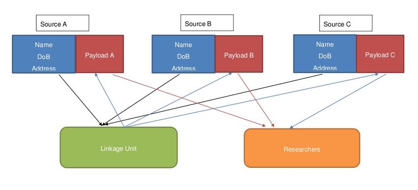
• geocode matching (match addresses to geographies (spatial analysis of health or
     geographical information)).

    Objects that are subjects for linkage: patients (in health), customers (in business),
taxpayers, travellers, business data, consumer product (e.g. for product comparison).
One of the main challenges for linkage is that the unique identifiers are not available in
all the databases. This is why the attributes that identify entities need to be used for
matching. In many cases we have to work on the person (e.g. personal identifiers: names,
addresses, dates of birth, etc.) or object description level and we have to apply string
comparison to find matching records [3].
    The history of data linkage starts in 1950 when the initial techniques were developed.
They were ad hoc heuristic methods comparing names, addresses and dates of birth for
linking personal information. The first probabilistic methods were introduced in 1962 by
Newcombie and Kennedy [4] and theoretical foundations were introduced in 1969 by Fel-
legi and Sunter [5]. Since then many new methods and approaches have been proposed in
fields such as statistics, computer science, databases or information retrieval. Currently,
many domains are interested in record linkage to provide new methods for linkage focus-
ing on the scalability and linkage quality (e.g. indexing and blocking techniques) due to
a ”big data” availability.

1.2     Record linkage process
The process of record linkage consists of three major steps: blocking/indexing, record
pair comparison and classification of the compared records. Figure 1.1 presents the full
process of record linkage for two datasets. Data cleaning and standardisation is a step to
processing the data from datasets into the same format. This will lead to a better linkage
quality. In the next step, we apply indexing, searching or filtering techniques to simply
not run the pairwise comparison. This allows us to select candidate records with some
similarity. Then we compare them based on the similarity of the linked attribute values
and we classify them into three classes: matches (records that are highly similar to each
other), non-matches (records that are completely different) and potential matches
(records for which some linking attribute are similar and some are different). The third
class is further manually reviewed to decide if records in that group are matches or non-
matches. Such process is often called an active learning because the feedback from the
manual review is returned to the classifier. At the end, we evaluate linkage process. The
following subsections will describe these steps in detail.

1.2.1    Data cleaning standardisation
Data cleaning and standardisation depend on the quality of data. While cleaning can
improve linkage rates, the cleaning process can be quite labor intensive, so researchers
should consider the cost-benefit analysis before investing a significant amount of time on
cleaning the data. Cleaning has been highly recommended if the data quality is poor
and/or only a few identifiers are available [7]. There are the following problems with
data:

  1. typographical errors (spelling errors, variation of names, different details for the
     same person in various datasets),

                                            3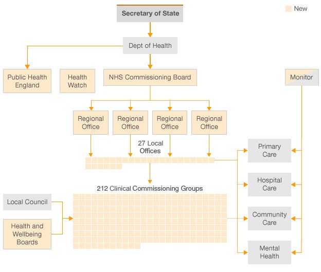
Figure 1.1: Linkage record process [6].

  2. different coding schemes (e.g. male/female vs M/F vs 1/2 etc.),

  3. missing data,

  4. changing data over time.

   There is a number of data cleaning techniques that are used in record linkage [6, 7, 8].
Some techniques increase the number of variables by splitting apart strings, where other
techniques transform variables into a specific representation:

   • reformatting value - ensures that data is in a common standard in all datasets
     for comparison during linkage process. The data can be easily changed to a new
     format without creating and removing information. For example, a date’s format
     01/05/2016 and 1st August 2015 can be reformatted to the same format.

   • removing punctuation - unusual characters and punctuation are more likely to be
     misrepresented, this is why it is important to remove them from the alphabetic
     values

   • removing missing values and not meaningless values - removing values such as NA,
     9999 999 for a postcode, “NO ADDRESS”, etc. These values are often inserted
     if there is no information available. It is important because their presence will
     increase the number of mismatches during the linkage process.

   • phonetic encoding - some variables (e.g. surname) they may be inserted with a
     phonetic error, they can have different spelling but the same sound. Such errors

                                            4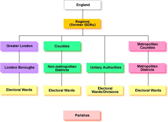
should be corrected before linkage process. There is a list of available software:
     Soundex [9], methaphone [10], NYSIIS [11].

   • name and address standardisation - name parsing is a process of breaking down a
     person’s full name into individual parts. Also, addresses should be broken down into
     smaller components such as street number, street name and street type. This can be
     done applying rule-based methods (e.g. royal mail rules for formatting addresses)
     or probabilistic methods (hidden Markow models [12]). The first method can be
     time-consuming, complex to develop and maintain the set of rules. The second
     methods require a training dataset as it is a learning process.

   • nickname/abbreviation lookups - all short names and abbreviation should be ex-
     panded. This can be done by creating lookup tables and used them in the data
     standardisation process.

1.2.2    Blocking, indexing and comparison
Blocking, indexing or filtering was introduced to reduce the number of comparison of
records pairs by bringing potentially linkable record pairs together [13]. In traditional
blocking [5] a database is split into smaller blocks according to some criteria (known as
a blocking key). The records pairs with the same blocking key value from two databases
are compared. It is important to find blocking criteria that have an even distribution.
For example, postcodes have a similar household count or people population. A phonetic
coding for names is another example, similar names should be considered together in a
block. Within each block, the records are compared based on string comparison for the
linking attributes. There are many techniques for string comparison [6] and the most
used for linkage are listed below:

   • deterministic linkage: exact comparison of two attribute values

   • q-gram: a string is converted into q-grams substrings of length q using a sliding
     window approach (e.g. ”road”={”ro”, ”oa”,”ad”} for 2-gram). In the next step, we
     count q-grams that occur in two strings and we use measure (e.g Dice coefficient)
     to calculate the similarity between strings.

   • edit distance: is based on a string metric for measuring the difference between two
     sequences. It includes a number of character edits (insert, delete, substitute) needed
     to convert one string into another [14]. The basic edit distance, is also known as the
     Levenshtein edit distance. There are a variety of dynamic programming algorithms
     to calculate this distance.

   • probabilistic record linkage: compare records attributes using string comparison
     functions. These functions are type specific: different for dates, addresses, and
     strings. The similarity (a matching weight) is calculated to the pair of corresponding
     attributes). Those weights are sum up. Based on this summarised weight we classify
     a pair of records as a match, non-match or potential match. This approach requires
     an estimation of errors for weight calculation, finding optimal thresholds for cutting
     off matches and non-matches and finally there is a manual clerical review needed
     for potential matches.

                                            5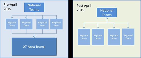
1.2.3    Classification - general linkage techniques
The classification of the candidate record pairs generated in the indexing step is based
on the similarity values calculated in the comparison step. More similar two records are,
the more likely they refer to the same real-world entity [6]. The classification approaches
can be divided into three main groups:
   • deterministic algorithms - determine whether record pairs agree or disagree on a
     given set of attributes, where agreement on a given attribute is assessed as a discrete
     “all-or-nothing” outcome. There are two methods: exact linkage if high quality
     identifiers (for linking attributes) are present. Identifiers must be precise, robust
     and stable over time. The second method is rule-based matching. This method
     is very complex to build and difficult to maintain. The rule methods are data
     dependent, they should be changed when data changes. There are algorithms that
     learn rules from data but they require a training dataset which is challenging (many
     areas do not have gold standard data that can be used for training purposes).
   • probabilistic algorithms - classify record on matches, non-matches, possible matches
     based on the similarity of the linking attributes. Probabilistic methods are often
     called fuzzy matching and take into account a wider range of potential identifiers
     and compute weights for each identifier based on its estimated ability to correctly
     identify a match or a non-match, and using these weights to calculate the probabil-
     ity that two given records refer to the same entity. Record pairs with probabilities
     above a certain threshold are considered to be matches, while pairs with proba-
     bilities below another threshold are considered to be non-matches; pairs that fall
     between these two thresholds are considered to be ”possible matches”. Whereas
     deterministic record linkage requires a series of potentially complex rules to be pro-
     grammed ahead of time, probabilistic record linkage methods can be ”trained” to
     perform well with much less human intervention.
   • computer science approaches - have become more popular recently. They are based
     on machine learning, data mining, and databases algorithms. A classification ap-
     proach can be unsupervised or supervised. Unsupervised methods group pairs of
     records based on the similarity between them without information about the char-
     acteristics of true matches and true non-matches. Examples of unsupervised meth-
     ods: clustering, collective classification (e.g. hierarchical clustering, graph-based
     approach - linked relationship graph between entities). The supervised approach
     requires a training dataset with match and non-match characteristics. The accu-
     racy of the built classification model is evaluated using a set of testing data that
     must be in the same format and structure as the training data. The example of the
     supervised methods: decision trees, support vector machine.

1.2.4    Record linkage evaluation
Record linkage is evaluated by measuring the linkage complexity and quality [6]. There
are two main measures for linkage complexity:
   • reduction ratio - how many candidate records pairs were generated by blocking
     compared to all possible pairs?
                                        number of candidate pairs
                             rr = 1 −
                                           number of all pairs

                                             6
The smaller number of pairs in blocking the larger the ratio, which means that we
reduced the complexity of linking process.
• pair’s completeness - how many true matches were generated by blocking divided
by all true matches?
number of true matching candidate pairs
pc = 1 −
number of all true matching pairs
These two measures tell us how good the blocking method is. To measure a general
linkage quality we need to have information about true matches, what can be difficult in
many areas. There are two types of errors:
• false non-match - a missed true match (false negative)
• false match - a wrong match (false positive).
A calculation of accuracy as percentage of false matches and false non matches is not
meaningful. A classification of all records as non matches can still give a high accuracy.
In this case it is better to use two measures that focus on true matches:
• precision: how many true matches are in the set of classified matches? (How many
elements are relevant?)
number of true matches pair tp
prec = =
number of all classified matching pairs tp + f p
• recall how many true matches did we find from all known true matches?
number of true matches pair tp
prec = =
number of all true matching pairs tp + f n
1.3 Advanced record linkage techniques
In recent years various indexing techniques for record linkage have been developed [15, 16]
In the traditional standard blocking approach, all records that have the same blocking
key value are inserted into the same block, and only the records within the same block
are compared with each other in detail in the comparison step. Each record is inserted
into one block only. To control better a number of comparisons the following techniques
have been introduced:
1. sorted neighbourhood approach - a sliding window of fixed size is moved over sorted
database tables. Candidate record pairs are generated from the records that are
within the current window. This method allows to control the number of compar-
isons and has a linear complexity [17, 18].
2. Q-gram blocking - convert values to the q-gram lists then generate sublists. Records
are inserted into several blocks by generating variations of the record’s blocking key
value through the use of q-grams (substrings of length q characters) [16, 15].
3. canopy clusters - overlapping clusters - similarity of string record is calculated based
on q-grams. Records are inserted into several clusters. Each cluster forms one block
from which candidate record pairs are generated [19, 20]
74. string map based blocking - this technique based on mapping block key values into
multi-dimensional space such that distances between strings are preserved [21]
5. controlling block size - important for real-time application and privacy-preserving
record linkage (iterative split-merge clustering approach) [22]
Advanced classification techniques view record pairs classification as multidimensional
binary classification problems. These methods use attribute similarities to classify record
pairs as matches or non-matches (there is no summarised similarity for two records).
There are three main techniques: machine learning, collective classification and group
matching. Machine learning techniques can be split on:
• supervised: require training data (records with true matches and non-matches. The
training data has to reflect the real data variation (twins or the same person with
changed name and address). For learning decision trees, neural networks, SVM and
other known machine learning methods are used.
• active and semi-supervised learning: require training data. Dataset is sampled
using bootstrapping, and the initial classifier is built. Then we apply it on the
entire dataset. We select “clear/obvious“ matches an non-matches and used then
as a training data to train a new classifier. Active learning is when we use a human
being to help classify difficult cases.
• unsupervised: does not require training dataset. Using clustering methods we group
pairs of records based on their similarities.
1.4 Privacy-preserving record linkage
In privacy-preserving data mining (PPDM) the main goal is to perform “data mining“
computations on a set of data, in a way that prevents both the computation and the out-
put of the computation from revealing too much sensitive information about the units rep-
resented in the data [23]. Similarly to privacy-preserving data mining, privacy-preserving
record linkage provides a secure way for record linkage where none can find out about
sensitive data [24]. This is used in cases where two or more organisations, governmental
agencies or health institutions want to exchange data for integration without violating
data privacy. The main challenges are:
• encryption methods cannot be applied directly (e.g two matching record with differ-
ent name or address will be returned with different identifiers (encryption codes)),
• techniques must not be vulnerable to any kind of attack,
• techniques should be scalable to linking large databases.
In the health domain, the privacy preserving record linkage protocol was proposed in
[25] and is presented in Figure 1.2. In the first step, the data source owners send the
identifying information to a linkage unit. Linkage unit is a trustee organisation which can
see the personal data for linkage. The sent data is encrypted but linkage unit decrypts
it and processes linkage on row data following the record linkage process. Linkage unit
sends the linked record identifiers back to the database sources. In the next step, the
payload information is attached to the linked record identifiers and such data are sent to
8Figure 1.2: Linkage record process.
researchers or third party working on linked data. In such scenario the privacy-preserving
record linkage aims:
• to secure that no encrypted data ever leave a data source
• only details about matched records are revealed
• secure against various attacks.
Basic PPRL protocols:
• two-part protocol - only the two database owners participate in the PPRL process.
It is more secure, no possibility of collusion and it has a lower communication cost.
This method requires more complex techniques to ensure that the two database
owners cannot infer any sensitive information from each other during the linkage
process.
• three-party protocol - a (trusted) third party (which is called a ‘linkage unit’) is
involved in conducting the linkage, possibility of collusion between linkage unit and
one of the data sources.
1.5 Open source linkage software
There is a large number of various software for data linking. They mostly were devel-
oped by researchers as part of their work of inventing new and improved data matching
algorithms and techniques. Some of them include the graphical user interface and func-
tionality allowing data cleaning and standardisation. Below there is a list of few of them.
• Febrl - A Freely Available Record Linkage System with a Graphical User Inter-
face (Febrl) [26] implemented in Python is a free object-oriented programming lan-
guage that is available on all major computing platforms and operating systems. It
contains many recently developed advanced techniques for data cleaning and stan-
dardisation, indexing (blocking), field comparison, and record pair classification,
9and encapsulates them into a graphical user interface. Febrl can be seen as a train-
ing tool suitable for users to learn and experiment with both traditional and new
record linkage techniques, as well as for practitioners to conduct linkages with data
sets containing up to several hundred thousand records [27].
• WHIRL - The Word-Based Heterogeneous Information Representation Language
system that allows various similarity string comparison functions (similarity joins)
to be applied on textual data system. The system is written in C++ and available
here [28].
• TAILOR - The Record Linkage Toolbox is a system for data matching including
integrated different indexing, comparison, and classification techniques (supervised
and unsupervised), as well as various evaluation methods. Standard blocking, sorted
neighbourhood approach, comparison and phonetic encoding functions are imple-
mented in this software. TAILOR is written in Java and is available by contacting
the developers [29].
• SimMetrics - is a system for approximate string comparison. It was developed in
Java, currently available at Sourceforge.net [30]
• R RecordLinkage - this is the R package that includes functions for standard
blocking, and several phonetic encoding and string comparison methods. Both
the probabilistic and deterministic matching approachs are included as well. The
package, example data sets, and a reference manual are available at [31]
• FRIL - The Fine-Grained Records Integration and Linkage system contains sev-
eral indexing methods (including standard blocking and the sorted neighbourhood
approaches), string comparison functions. This system can be run on multi-core
systems and it contains a GUI that allows users to easily set-up and customises
deduplication or data matching projects. FRIL was developed in Java available at
[32]. This system allows the pre-processing of attributes through the use of regular
expressions to standardise the input data and to split and merge attributes before
they are used for matching.
• BigMatch - The BigMatch system has been developed and is being used by the
US Census Bureau to match very large census data collections [33]. BigMatch is
not a full data matching system, rather it is a program that can be used to extract
potential matches from very large files that otherwise could not be processed. These
matches are saved into several smaller files so that they can be individually processed
with a proper data matching system later on. In contains a standard blocking
approach with several blocking criteria. This system was developed in C.
10Chapter 2
Linkage and mapping geographically
referenced data
Linkage geographically referenced data involve two approaches: address matching using
the string comparison methods described in the previous chapter or georeferencing and
mapping various geographies for the data aggregation purposes. In this chapter, various
English geographies are described together with their mapping methods.
2.1 UK geographies
In the United Kingdom, the Office for National Statistics holds and maintains a number
of codes that represent a large range of geographical areas. These codes (ONS codes
or GSS codes) refer to the Government Statistical Service of which ONS is a part. Ge-
ography provides a structure for collecting, processing, and storing the data. There are
many different geographic unit types (administrative, health, electoral, postcode etc) and
their boundaries frequently do not align. A range of geographies is frequently revised and
geographical boundaries are continuously changing [34]. Figure 2.1 presents the hierar-
chical representation of UK statistical geographies from October 2015. There is seven
main group of geographies: postal, administrative, health, census (statistical block and
merged geographies), electoral, Eurostat and other. In this document, only the main
English geographies are described in detail.
2.1.1 Postal geography
Royal Mail maintains a UK-wide system of postcodes to identify postal delivery addresses.
The Postcode Address File (PAF) is the latest, most accurate UK address database. It
contains 1.8 million UK postcodes and over 29 million residential and business addresses
[36]. These are constantly updated and verified by ninety thousand postmen and women,
making updates to 3,500 records each day. Postcode is used as the main geographic
reference when collecting data. This reference can be related to any geographic unit used
for statistical production, such as a local authority district or electoral ward. Figure 2.2
presents the structure of the postcode. It is a hierarchical structure supporting four levels
of geographic unit see Table 2.1.
There are two types of postcodes:
• Large user postcodes: allocated to single addresses receiving at least 500 mail items
per day (e.g. business addresses).
11Hierarchical Representation of UK Statistical KEY The country where
Geographies (September 2016) Electoral Wards (9,130)
Boundaries available on the Open Geography portal
http://geoportal.statistics.gov.uk the geography exists
Geography Entity Code Geography Name
E05, S13, W05, N08 NSPL E - England
For downloads and more information visit the ONS Geography Portal S - Scotland (Number of Instances)
http://geoportal.statistics.gov.uk W – Wales National Parks (15)
N – Northern Ireland Available on the National
E26, S21, W18
Without co-terminous boundaries
K – Cross-border instance NSPL Statistics Postcode
Contains Ordnance Survey data © Crown copyright and database right 2016 Produced by ONS Geography J - Experimental Lookup (NSPL)
National Assembly
Economic Regions (4)
W19 London Assembly National Assembly for Westminster Parliamentary Scottish Parliamentary District Electoral Areas Northern Ireland Assembly
Constituencies (14) Wales Constituencies (40) Constituencies (650) Constituencies (73) (80) Constituencies (18)
Dept. for Children, Education, E32 W09 E14, S14, W07, N06 NSPL S16 N10
Lifelong Learning and Skills (4)
W16 NSPL LAU2 Areas (10,192)
“Live” Unit Postcodes
S30, E05, W05 NSPL (1,738,975)
Strategic Regeneration Strategic Regeneration
NSPL
Sub-areas (2) Areas (7)
W27 W26
LAU1 Areas (415)
Spatial Plan Sub-areas (3) Spatial Plan Areas (6)
S31 NSPL
W23
National Assembly for Wales European Electoral Scottish Parliamentary “Live” Postcode Sectors
W24
Electoral Regions (5) Regions (12) Regions (8) (11,100)
W10 E15, S15, W08, N07 NSPL S17 Experimental
Agricultural Small Areas NSPL
Agricultural Regions (7)
(235)
Wales NUTS 3 Areas (173)
W30 W29
NSPL Major Towns and Cities
(112)
Transport Consortia Areas J01
(4)
Communities First Areas “Live” Postcode Districts
W28 (2,960)
(52)
NUTS 2 Areas (40)
W33
Wales Scotland NSPL
NSPL
Enterprise Zones (45)
E49
Police Force Areas (43)
LEP – non overlapping
Local Enterprise part (19) E23, W15 NSPL NUTS 1 Areas (12) Local Authority Districts
“Live” Postcode Areas
Partnerships (39) E53 Northern (121)
E37 NSPL NSPL England Ireland
Fire and Rescue UK NSPL Wales Unitary Authorities (22) Electoral Wards (852) Communities (870)
Authorities (48)
England
Primary Urban Areas (56) E31, W25 W06 NSPL W05 NSPL W04
E25
Registration Sub-Districts Registration Districts UK
(175) (175) England Combined Authorities (7)
Waste Authorities (6) & Wales
E29, W21 E28, W20 UK E47
E50
Electoral
Community Safety
Development LEP – overlapping part Partnerships (317) Inner and Outer London
London Boroughs (33)
Corporations (3) (15) E22, W14 (2)
E51 E52 Eurostat Postal E13 E09 NSPL
Local Resilience Forums
Regional Transport (42) Metropolitan Districts
Partnerships (7) Metropolitan Counties (6)
Enterprise Regions (6)
E48, W41 (36)
S07
Travel to Work Areas England E11 E08 NSPL
S09 (228) UK Electoral Wards (7,463)
Community Justice E30, W22, S22, N12, K01 NSPL
E05 NSPL
Authorities (8) Non-metropolitan
S25 Island Groups (57) Other Administrative Counties (27)
Districts (201)
E10 NSPL E07 NSPL
S36
Scottish Police Divisions
Police Force Area (1)
Scotland
(14)
S32 S23 NSPL National Parks (15) Unitary Authorities (56)
E26, S21, W18 NSPL
GB Northern E06 NSPL
Settlements (516) Localities (643) Ireland Civil Parishes (10,452)
2011 (Incomplete coverage)
Health
S20 S19
Census Council Areas (32) Electoral Wards (353)
E04
Scottish Fire and Rescue Local Senior Scottish Fire and Rescue Service Scottish Fire and Rescue 2011 S12 NSPL S13 NSPL
Officer Areas (17) Delivery Areas (3) Service (1) Scotland
Statistical England
S39 S40 S38 & Wales
Building Block Local Government
Electoral Wards (462)
England Districts (11)
Regeneration Outcome Regeneration Outcome Areas – Regeneration Outcome
Areas – Local Areas (180) Community Planning Partnership (28) Agreement Areas – Scotland (1) & Wales N09 NSPL N08 NSPL
S06 S05 S04 Scotland
Urban Regeneration England
Companies (6) England
Northern Northern
S10
Northern England Ireland Ireland
Ireland Cancer Registries (9)
Highlands and Islands
Enterprise (8) E20, W12
S24 Wales
Non-Civil Parished Areas NHS Commissioning
Broad Rental Market (219) Scotland Wales Regions (4) Sustainability and
Areas (18) E43 NSPL E40
Transformation Plan
S33
Footprints (44)
Police Force Area (1) Northern Ireland Fire and E54
Rescue Service (1) NHS Commissioning
Census Merged Counties Region (Geography) (14)
(35) Northern E39
E42 Ireland
Clinical Commissioning
Groups (209)
Police Force Districts (11)
Public Health England E38 NSPL
Northern Ireland Fire and Super Output Areas, Regions (4)
Rescue Service Areas (4) Upper Layer (94) E46
Settlement 2015 (639) W03
N11
Census Merged Local Health and Social Care
Authority Districts (346) Board (1)
Built-up Areas (5,830) E41, W40 NSPL
Super Output Areas, Intermediate Zones Super Output Areas,
Northern Ireland Fire and E34, W37, K05 NSPL Middle Layer (6,791) (1,279) Middle Layer (410) Public Health England
Rescue Service Districts E02 NSPL S02 W02 NSPL Centres (9)
(14) E45
Scotland
Health Boards (14)
Cancer Networks (2) S08 NSPL
Super Output Areas, Super Output Areas,
Data Zones (6,976) Super Output Areas (890)
Census Merged Wards Lower Layer (32,844) Lower Layer (1,909) W13
Workplace Zones (53,578) (8,546) E01 NSPL S01 W01 NSPL NSPL
Strategic Clinical
E36, W39
E33, W35 NSPL Networks (13)
E55
Local Commissioning Local Health Boards (7)
Built-up Area sub- Census Detailed Census Local Groups (5) Integration Authorities
divisions (1,826) Output Areas (171,372) Output Areas (46,351) Output Areas (10,036) Small Areas (4,537) (31)
Characteristics (866) Characteristics (1012) NSPL W11 NSPL
E35, W38, K06 NSPL S28 S29 E00 NSPL S00 NSPL W00 NSPL N00 NSPL S37 NSPL
Figure 2.1: Hierarchical Representation of UK Statistical Geographies [35].
Figure 2.2: Postcode structure.
• Small user postcodes: collections of (usually) adjacent addresses. A single small
user postcode may contain up to 100 addresses, but 15 is a more typical number.
Linking postcodes with other geographies is not straightforward:
• Postcode boundaries do not align with other geographic boundaries. A manual
assignment of the postcode to the other geography is necessary when the postcode
straddles the boundary of a chosen geography (e.g. ward or output area). Usually,
it is done by allocating the postcode centroid within the given area boundary [37].
• Postcode boundaries are constantly updated by adding new addresses, removing
not used ones.
2.1.2 Census geography
Census provides a detailed snapshot of the population and its characteristics. It is un-
dertaken every 10 years. The most recent was on 27 March 2011. The main geographies
directly associated with the Census are Output Areas (OA) and Super Output Areas
(SOA) [38]. Output areas are the base unit for Census data releases and the lowest ge-
ographical level at which census estimates are provided. Output areas were created for
12Geographic Unit Number in UK Example
Postcode Area 124 LS
Postcode District 3,114 LS2
Postcode Sector 12,381 LS2 9
Unit Postcode around 1.75 million LS2 9JT
Table 2.1: Postcode hierarchical structure.
Census data, specifically for the output of census estimates. Output areas are built from
clusters of adjacent unit postcodes. They were designed to have similar population sizes
and be as socially homogeneous as possible based on tenure of household and dwelling
type [39].
After Census 2011 the total number of output areas is 171,372 for England, they are
covered by super output areas. There are 34,753 lower layer super output areas (LSOA)
and 7,201 middle layer super output areas (MSOA). Table 2.2 presents the difference
between these areas on the number of population and household count.
Minimum Maximum
Area type People Household People Household Count
Output Areas 100 40 625 250 171,372
Lower Super Output Areas 1,000 400 3,000 1,200 34,753
Middle Super Output Areas 5,000 2,000 15,000 6,000 7,201
Table 2.2: Lower and upper thresholds for Output Areas
2011 Census estimates for electoral wards/divisions are aggregations of output areas,
on a best-fit basis [40]. Boundaries of output areas and super output areas are aligned
to local authority district (LAD) boundaries, including those that changed between 2003
and 2011, and also at the border between Scotland and England. For ward and local
authority information see the following section.
2.1.3 Administrative geography
Administrative geography represents the hierarchy of areas relating to national and local
government in the UK. There is a different structure in each constituent country of the
UK. The boundaries of many of the layers in the hierarchy are subject to either periodic
or occasional change [41]. Figure 2.3 presents the administrative hierarchical structure
for England.
There are nine government offices for the regions (GOR): North East, North West,
Yorkshire and The Humber, East Midlands, West Midlands East of England, London,
South East, South West. They are split into 322 counties. Metropolitan counties are six
heavily built areas (without Great London) divided into metropolitan districts. There are
36 metropolitan district councils as a single-tier authorities [42]. There are 27 counties
(shire) split into 201 non-metropolitan districts (LAD - local authority districts) and there
are 56 unitary authorities [43]. From 2000 Great London is subdivided into 32 London
boroughs with a status similar to metropolitan districts, and also the City of London.
The boundaries of all authority districts and London boroughs can be found in the local
authority district (LAD) boundary files [44]. There are 7678 wards and electoral division
in the UK see table 2.3.
13Figure 2.3: Hierarchical representation of England administrative geography [41].
Electoral wards/divisions are the smallest units so called ”building block”, from which
higher units are constituted. They are the spatial units used to elect local government
councillors in metropolitan and non-metropolitan districts, unitary authorities and the
London boroughs in England. English local authority districts (LAD) (both metropoli-
tan and non-metropolitan), London boroughs and unitary authorities average around 23
electoral wards or divisions each. Electoral ward/division boundary changes are usually
enacted on the first Thursday in May each year, to coincide with the local government
elections [45].
Area Type Name Count
Regions 9
Counties 35
- Shire (Non-metropolitan) 27
- Metropolitan 6
- Great London 2
Local Authorities 322
- Non-metropolitan districts 201
- Metropolitan districts 36
- Unitary authorities 56
- Landon boroughts 31
Wards and Electoral divisions 7678
- Census Wards 7218
- Census Electoral division 453
- Census Merged Wards 7
Parishes 10,449
Table 2.3: Hierarchy of the Census administrative geography
14Parishes are the smallest administrative type in England. They are a very old form
of a spatial unit which originally represented areas of both civil and ecclesiastical admin-
istration. Many parishes are a similar size to wards, but some can contain several wards,
and ward boundaries need not be followed. Parishes are confined within local authority
district boundaries but are not contiguous with electoral wards. As at 31 December 2015
there were 10,449 parishes in England [46].
2.1.4 Electoral geography
Electoral geography is a three-tier complex structure. There are three different electoral
systems and different areas used for election (see Figure 2.4):
• European and UK parliaments
• Devolved and regional governments
• Local authorities and smaller units
Figure 2.4: Hierarchical representation of electoral geography in UK [47].
The electoral hierarchy is the only electoral structure that covers the whole of the UK.
European electoral regions (EER) are used to elect Members of the European Parliament
(MEP) to the European Parliament in Strasbourg. England’s electoral regions are based
on the boundaries of the regions (former government office regions (GOR)) at the start of
the year of an election [48]. Westminster parliamentary constituencies are the areas used
to elect Members of Parliament (MP) to the House of Commons, which is the primary
legislative chamber of the UK and is located in Westminster, London. At the May
2010 General Election, there were 650 constituencies. Councillors in UK districts and
unitary administrations are elected to represent the same electoral wards/divisions that
are used to constitute Westminster parliamentary constituencies. County councillors,
however, represent larger ’county electoral divisions’, which are not necessarily based on
the electoral wards used at district level [49].
2011 Census estimates for electoral wards/divisions are aggregations of output areas,
on a best-fit basis. This is the method used to produce all 2011 Census and national
15statistics so that statistics estimates produced on the same geography are consistent,
comparable and non-disclosive.
2.1.5 English health geography
A new structure of health geographies in England is valid from 1 April 2013. This
structure (Figure 2.5) consists of:
• NHS commissioning regions (NHSCR)
• NHS area teams (NHSAT)
• clinical commissioning groups (CCG)
Figure 2.5: Hierarchical representation of English health geography [50].
There are four NHSCRs in England: London, Midlands and East, North and South.
These regions cover healthcare commissioning and delivery across their geographies and
provide professional leadership on finance, nursing, medical, specialised commissioning,
patients and information, human resources, organisational development, assurance and
delivery.
There were 27 NHS area teams (NHSAT) that were responsible for GP and dental
services, pharmacy services and certain aspects of optical services. Ten of the teams led
on specialised commissioning across England and a smaller number of NHSATs carry out
the direct commissioning of prison and military health.
There are 211 clinical commissioning groups set up by the Health and Social Care
Act 2012 to organise the delivery of NHS services in England. They are clinically led
groups that include all of the general practice groups in their geographical area. The aim
of this is to give GPs and other clinicians the power to influence commissioning decisions
for their patients. CCGs are overseen by NHS England (including its regional offices and
area teams). These structures manage primary care commissioning, including holding
the NHS contracts for GP practices. CCGs have boundaries that are coterminous with
those of lower layer super output areas.
This new structure has replaced the strategic health authorities (SHA) and primary
care organisations (PCO) that had been in operation since July 2006 see Figure 2.6.
There were 10 strategic health authorities which boundaries aligned with regions. Only
South East region comprised two SHAs. There were 152 primary care organisations: 148
primary care trusts (PCT) and four care trusts (CT). They were constituted from groups
of local authority districts.
16Area Type Count
NHS Commissioning Regions 4
NHS area teams 27
Clinical Commissioning Groups 211
Table 2.4: Hierarchy of the Census health geography
Figure 2.6: Hierarchical representation of English health geography [50].
The entire NHS structure in England is presented in Figure 2.7. The Secretary of State
has overall responsibility for the work of the Department of Health. The Department of
Health is responsible for strategic leadership and funding for both health and social care
in England. Public Health England provides national leadership and expert services to
support public health, and also works with local government and the NHS to respond to
emergencies [51] The local council’s role is tracking public health problems (e.g. obesity,
smoking etc) in their area with the support of health and well-being boards.
Figure 2.7: NHS structure in England [52].
Despite that the ONS officially publishes on its website two tier for commissioning
regions, in April 2015 the area teams were integrated into existing four regional teams
(see Figure 2.8) and operate as a single tier [53]. The resent realise of ONS hierar-
chical representation of UK statistical geographies in September 2016 presents two-tier
geographies for NHS Commissioning Regions: NHS Commissioning Regions (4) and NHS
Commissioning Regions Geography (14)- see Figure 2.1.
17Figure 2.8: NHS Commisioning Regions [51].
2.1.6 Other geographies
In Census 2011, there is a number of geographical units for which statistics are produced
with lists of names and codes. For those units we include:
• Build-up areas - a list of the most populated urban areas. Data provides information
on the villages, towns and cities where people live, and allows comparisons between
people living in urban areas and those living elsewhere.
• Travel to Work Areas - a list of wards for which most of the working residents works
in the same area.
• Local Education Authority and Library Board - a list of local councils in England
and Wales that are responsible for education within their jurisdiction.
• National Parks - a list of National Park Authority (NPA) that are responsible
for conservation, planning, recreation management and fostering the social and
economic well-being of local communities.
• Registration Districts - a list of areas for which records of births, deaths and mar-
riages are kept.
• Police Force Areas - a list of territorial police forces.
• Fire and Rescue Authorities - list of local fire authorities.
2.2 Linking geographically referenced data
Geographic location is an element of information that allows defining object position on
the earth. Geodata describes the location and characteristic of the real-world object such
as houses, roads, boundaries of land parcels, rivers, etc in digital format. A geographically
referenced object has two main elements: location and its characteristics. There are two
ways to describe a geographical location:
• Direct georeference: the information about the location is defined by two- or
three-dimensional coordinates in a coordinate reference system. Direct references
for geographical objects are generally obtained from physical surveys, remote sens-
ing, digitising of documentary sources or direct capture by Global Positioning Sys-
tem (GPS) receivers
18• Indirect georeference: the information about the location is defined as admin-
istrative areas, postal addresses, postal codes and place names. It does not include
explicit coordinates. It is entirely possible to work with geographically referenced
data without having direct geographical references, for example by matching two
sets of indirect references together (e.g. a postcode and a census ward code) in
order to link records from different datasets. However, it is not possible to produce
digital maps without using direct references [54].
Spatial Linkage can be understood as a link between direct and indirect referencing.
It takes a form of standard reference datasets such as lookup table or digital boundary
data. It contains both information: names from indirect referencing and coordinates from
direct referencing.
Figure 2.9 presents the example of linkage of asthma rates with area deprivation scores.
Assume that we have one dataset with information on asthma rates published for GP
practices and second dataset with the deprivation scores for super output areas. To link
such data, in the first step we extract postcodes of GP surgeries and their geographical
locations and then we map these postcodes to the super output areas. This can be done
by using Geographical Information System to geocode addresses and then map them to
the super output area’s boundaries or using the ONS lookup files.
Figure 2.9: Example of linkage two dataset using georeference and geographical lookup
table [55].
2.2.1 ONS files
The areas from 2011 census are mostly arranged in hierarchies in which one or more areas
from a lower level are combined to form a single area in a higher level. For instance, ward
areas can be combined to form local authority levels. The hierarchical relationships of
the area sets for three main geographies (health, administration and census) are sum-
marised in the diagram in Figure 2.10. As it was mentioned in Section 2.1, generally
the boundaries of various geographies areas do not align with a few exemptions. Figure
2.11 presents the relationship between various geographies. They were extracted from
the geography’s descriptions. The black lines (within and across geographies) represents
the areas with the conterminous boundaries aliments. The dash lines represent areas that
split other geography’s areas.
Linking data on the postcode level with data on the output area level we may find that
one postcode will be linked with two output areas. This can cause problems for statistics
because the postcode data will be aggregated twice in each output area statistics. To avoid
such situation, ONS introduced the best-fit approach. This approaches used output
areas as building blocks for any target geography. An estimation is made by aggregating
whole output areas of statistics together to form the total estimate for the geography.
19Either all the statistics for that output area will be included in the aggregation, or they
will be excluded. For each output area, a single point was calculated to represent the
spatial distributions and grouping of persons within that output area. This point is known
as a population weighted centroid. If the output area’s population weighted centroid falls
within the boundary of the target geography, the output area will be included in the
Countries
NHS Commissioning
regions Regions
NHS Commissioning Counties
regions geography
Local
Authorities
CCG
MSOA
Electoral
LSOA Wards/divisions
Output Areas
Postcodes
Figure 2.10: Hierarchical structure of English geographies.
Electoral Geography
Postal Geography Postcodes
European Electoral Areas
Health Geography
Regions
NHS Commissioning
Regions Postcode
Westminster District
Parliament
NHS Commissioning
Regions Geography Postcode
Sector
Electoral Words
Clinical Commissioning
Groups Unit
Postcode
Administrative Geography Census Geography
Electoral Output Areas
Wards/Divisions
Local Authority Districts Lower Super
Output Area
London Non-metropolitan Unitary Metropolitan
Boroughs Districts Areas Districts
Middle Super
Output Area
Grater Metropolitan
Counties Counties
London
Figure 2.11: Hierarchical structure of English geographies.
20best-fit allocation of output area to that target geography. This should ensure that
where an output area crosses the boundary of the target geography, it is allocated to the
geography that contains the majority of the output area’s population. Some instances of
geographies, for example parishes, that are smaller than an output area, and which do
not contain an output area centroid, will be allocated to the output area with a centroid
that is nearest to any part of the target geography’s boundary. [56].
The ONS Open Geography Portal [57] provides free and open access to the definitive
source of geographic products, web applications, story maps and services. The user can
browse data, geography boundaries, maps, documents, postcode products, lookup tables.
UK Geography names and codes database
The Code History Database (CHD) contains the GSS nine-character codes that were
allocated for current and new statistical geographies from 1 January 2009. This database
includes details of codes, their relationships, hierarchies and archived data. The MS
ACCESS database provides multi-functionality and enables user to view or export data
for the following options (see Figure 2.12):
• Geography Listings - includes both terminated and live entities, and codes for ge-
ographies
• Geography History - contains the change history
• Geography Hierarchies - provides the hierarchies for all entity themes where a one-
to-one relationship exists. The file extracted here can be used as lookup tables for
geographies described in the Section 2.1
• Geography Constitutions - provided for some geographies in England and Wales.
These include parish to ward, electoral and health constitutions
• Geography Equivalents - provides the new codes and previous ONS, CLG, DH and
other equivalent names and codes where available
• Geography Information - contains information about the geographies including
Statutory Instrument Information
The current database was released on 7 September 2016 and is available as a zip file1 .
This database is updated quarterly.
Lookup files
Using best-fit approach, ONS provide a list of lookup tables with names, codes and
relationship between geographies [58]. There are following lookup tables [59]:
1. 2001 to 2011 Census lookups - A range of cross-reference tables to allow linkage
between the 2001 and 2011 output areas and super output areas.
2. Lookups for 2011 output areas to other geographies:
• 2011 output areas to 2011 wards
1
http://ons.maps.arcgis.com/home/item.html?id=210eb9e8c06e45db8119a42dcedcf8cd
21Figure 2.12: The Code History Database
• 2011 output areas to 2011 parishes
• 2011 output areas to current counties in England
• 2011 output areas to regions in England
• 2011 output areas to 2010 Westminster parliamentary constituencies and Eu-
ropean electoral regions (with best-fit percentage indicator)
• 2011 output areas to 2011 primary care organisations (PCO) in England/local
health boards (LHB) in Wales and strategic health authorities (SHA) in Eng-
land (with best-fit percentage indicator)
• 2011 output areas to 2011 built-up area sub-divisions (BUASD), built-up areas
(BUA), local authority districts (LAD) and regions
• 2011 built-up areas to 2011 local authority districts
• 2011 build-up areas to 2011 regions
• 2011 output areas to 2011 urban/rural definition
• 2011 output areas to 2011 enumeration postcode sectors
• 2011 output areas to 2011 lower layer super output areas (LSOAs), middle
layer super output areas (MSOA) and local authority districts - exact fit
• 2011 output areas to 2011 workplace zones (WZ) and local authority districts
- exact fit
3. Other geographies
22• 2011 enumeration postcodes to 2011 output areas (OA), lower layer super
output areas (LSOA), middle layer super output areas (MSOA) and local
authority districts (LAD) (with split postcode indicator)
• 2011 wards to 2011 Census merged wards (as used for Census upper-threshold
statistics)
• 2011 workplace zones (WZ) to 2011 MSOAs and LADs
More lookup files for various geographies and the newest releases can be found in [57].
Postcode lookup files
The ONS Open Geography Portal provides a number of postcode lookup files. There are
four main lookup files:
• National Statistics Postcode Lookup (NSPL) - relates both current and terminated
postcodes in the United Kingdom to administrative, electoral, health and other sta-
tistical geographies via ‘best-fit’ allocation from 2011 Census Output Areas (OA).
The last release was in August 20162 . The file is issued quarterly.
• ONS Postcode Directory (ONSPD) - relates both current and terminated post-
codes in the United Kingdom to administrative, electoral, health and other area
geographies. It links postcodes to pre-2002 health areas, 1991 Census enumeration
districts for England and Wales, 2001 Census Output Areas (OA) and Super Out-
put Areas (SOA) for England and Wales, 2001 Census OAs and SOAs for Northern
Ireland and 2001 Census OAs and Data Zones (DZ) for Scotland. The last release
was in August 20163 .The file is issued quarterly.
• NHS Postcode Directory (NHSPD) - relates both current and terminated postcodes
in the United Kingdom to administrative, electoral, health and other geographies. It
links postcodes to pre-2002 health areas and 2001 Census and 2011 Census Output
Areas and Super Output Areas. NHSPD uses information supplied on a monthly
basis by Royal Mail. This product contains Royal Mail, Gridlink, LPS (Northern
Ireland), Ordnance Survey and ONS Intellectual Property Rights. The last release
was in August 20164 . The file is issued quarterly.
2.2.2 Linkage using GIS
Geographical Information System (GIS) is designed to capture, store, manipulate, anal-
yse, manage, and present all types of spatial or geographical data. GIS can show many
different kinds of data on one map. This enables people to more easily see, analyse, and
understand patterns and relationships [60].
The different shapes and symbols are used to illustrate features. There are four main
types of symbol used to represent the different feature types:
• Point - for example, a dot symbol to represent a house or a cross to represent a
church
2
http://ons.maps.arcgis.com/home/item.html?id=ad13ce429d9644b88fc1e85af2e6ed8a
3
http://ons.maps.arcgis.com/home/item.html?id=5a656df5f06b4325aa83f907cf0e8d
4
http://ons.maps.arcgis.com/home/item.html?id=dc23a64fa2e34e1289901b27d91c335b
23You can also read