REPORTER - Leica Geosystems
←
→
Page content transcription
If your browser does not render page correctly, please read the page content below
REPORTER
CONTENT

4    From the laser scanner to office in near real time
     Case Study
8    Measuring high in ports
     Case Study
12   Reference station user strategies in
     a tectonic environment
     Case Study
16   Modelling for monitoring - When millimetres matter
     Case Study
20   Improving the railway infrastructure of a capital city
     Case Study
24   The chronicle of an adventure
     Case Study
28   Triple I: Innovation in India
                                                              24      THE CHRONICLE OF
     Case Study
                                                                      AN ADVENTURE
30   Shaping change in construction with
     HxGN SMART Build
     Feature
                                                              ECO40 boat trip research to provide ocean
32   From the sky to the ground – Positioning heavy
                                                              scientific information
     construction machines with precision
     Feature
34   Seeing behind to save up front
     Case Study
36   Understanding the snowmelt
     Case Study
40   Digital monitoring of major urban construction sites
     Case Study
44   Ensuring sound infrastructure
     Case Study
48   The evolution of LiDAR
     Feature
52   Integration is the key to success in mining
     Case Study
56   Speed is the name of the game
     Expert Insights
60   Fusing perception and reality
     Events
64   Around the World                                         36      UNDERSTANDING THE
     HEXAGON Geosystems features customers                            SNOWMELT
66   In Your Words
     Leica Cyclone REGISTER 360 laser scanning software
67   News                                                     Hydrologic research using Leica Geosystems
     Latest Geosystems happenings                             GNSS solutions to measure the impacts of a
69   Contributors                                             changing climate in the Canadian Arctic
     Meet our writers
REPORTER 80

                                           President’s Message

                                           When a business digitises, it becomes more efficient in
                                           how it produces, shares and evaluates information. When
                                           it digitalises, though, it undergoes a transformation to
                                           become a connected ecosystem. This transformation through
                                           digitalisation is the focus for this edition of Reporter.

                                           The heavy construction industry is finding efficiencies and
                                           productivity through the use of the global GNSS correction
                                           service, HxGN SmartNet. Heavy machine operators in
                                           Denmark share how the digitalisation of the industry is
                                           increasing their bottom line and making their work easier.

                                           The Rail Division of Atkins, the design, engineering and project
                                           management consultancy, is not only connecting its business
                                           through digitalisation but also bringing more efficient public
                                           transportation to London on a major upgrade project to the
                                           rail infrastructure leading into and around the capital city.
                                           Using a combination of Hexagon Geosystems measurement
                                           solutions, from GNSS to digital levelling, the company was
                                           able to provide quicker data visualisation and safer operations
                                           to the government entity responsible for the project.

                                           The European gas infrastructure company providing the
                                           transport of natural and green gas in the Netherlands,
                                           Gasunie, found transformation through the integration of
                                           several Geosystems technologies. Creating a connected
                                           ecosystem of customers and subcontractors, Gasunie made
                                           laser scanning data available directly from the field to the
                                           stakeholders through laser scanning, immersive software and
                                           remote access platforms.

                                           Transformation through digitalisation is how business and
                                           industries advance. Connecting is how we ensure we remain
                                           relevant and aren’t left behind.

                                           We’re committed to bridging the gap from digitisation to a
                                           digitalisation transformation. We vow to keep innovating to
                                           move ourselves and the industries we support forward.

                                           Enjoy your read.

40      DIGITAL MONITORING
        OF MAJOR URBAN
        CONSTRUCTION SITES

Capturing tunnel construction from above   Jürgen Dold
in Germany
                                           President, Hexagon Geosystems
© Gasunie

                              FROM THE LASER
                              SCANNER TO
                              OFFICE IN NEAR
                              REAL TIME
                              Joost Assendelft        Case Study

                              Using 3D laser scanning to revise the gas transport network
                              in the Netherlands

            4 | Reporter 80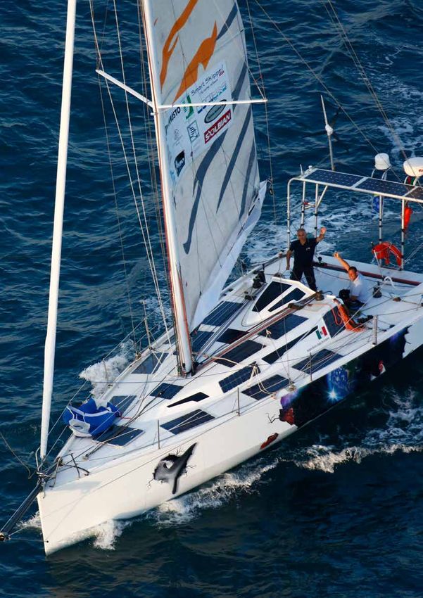
© Gasunie
To move gas safely and reliably to the end            directly from the field to the customer and
consumer, the Netherlands has a high-quality          subcontractors, Gasunie can now save time
gas transportation network. For undisturbed           and money with their re-designed Leica HDS
gas delivery, it is important that the network        workflows. Before integrating Leica Geosystems
is always in excellent condition. Therefore,          solutions, the time to deliver the as-built
Gasunie, a European transmission system               situation took quite long – now, a precise
operator that provides the transport of natural       as-built model is ready within 24 hours.
and green gas in the Netherlands and the
northern part of Germany, performs daily              THE MIX AND MATCH SOLUTION
management and maintenance work to the                To accelerate and improve the overall process,
main gas transportation network and to the            a pilot has been conducted in combination with
regional gas transportation network.                  Advin advisory and engineering firm using 3D
The network in the Netherlands includes:              laser scanning. The working process has been
                                                      reviewed and innovative steps have been taken
■■   12,500 kilometres of pipeline                    in the data processing by using Leica JetStream
■■   3,000 valve schedules                            software for simplified point cloud access and
■■   80 measuring and control stations                ultra-high speed rendering.
■■   1,000 gas receiving stations
■■   13 compressor stations.                          After the design, prefabrication and transport
                                                      of the parts, the new installation is assembled
During the execution of maintenance and               on site. This installation is checked using a Leica
replacements, the delivery of gas to end              Viva GS16 GNSS Smart Antenna and a Leica
customers continues. It is, therefore, a              Nova MS60 MultiStation linked to a CS35 tablet
challenge to cause as little inconvenience as         computer with Leica Captivate software. Inside
possible. For this reason, Gasunie first makes        the Captivate software, the Inspect Surface
a detailed design of the pipes. Based on the          app looks at whether there are deviations
design, the new components are prefabricated,         between model and as-built situation and will
so that the installation work in the field takes as   determine whether the new situation meets the
little time as possible.                              requirements of Gasunie.

Combining multiple Leica Geosystems solutions         The entire installation is mapped either with the
that make laser scanning data available               MultiStation or with a Leica ScanStation P40.

                                                                                                            Reporter 80 | 5
© Gasunie

                              This measurement is processed and checked           point cloud for discussions using digital reality,
                              in the field and uploaded directly to JetStream     making better informed decisions if needed.
                              server via a mobile 4G connection on the CS35.
                                                                                  The smart point cloud technology in JetStream
                              “The system Leica Geosystems has developed          allows data to be viewed and used without delay
                              fits optimally to optimise our workflows. From      via an online connection without missing any
                              the design to the final stage of a construction,    detail. There is only one version of the point
                              this method of working reduces time and,            cloud and, therefore, only one backup has to be
                              therefore, saves money. In particular, the          made. Unnecessary copies belong to the past.
                              saved point cloud as asset information during
                              the construction phase may become useful            THE SELECTED CHOICE WHEN IT HAS TO
                              many years later. We are furthermore capable        BE RIGHT
                              to scan brownfield assets and transform this        Thanks to Leica Geosystems combined
                              to real 3D-asset information with new (future)      solutions, the 3D design generated with the
                              functionality,” said Sijbrand Stratingh, senior     point cloud can seamlessly be adapted to
                              pipeline engineer at Gasunie.                       the as-built situation. Gasunie no longer has
                              BENEFITING FROM THE INDUSTRY-                       any need to create a completely new as-built
                              LEADING POINT CLOUD PROJECT SERVER                  drawing from scratch. An update of the
                                                                                  3D-model is sufficient.
                              The use of JetStream server has a number of
                              important advantages. The data is centrally         “We always strive to work with state-of-the-art
                              available in the cloud so engineers involved can    hardware and software that can provide the
                              directly access the data. Because the point         best solution to our customer. The choice for
                              cloud is available online, Gasunie can also         Leica Geosystems, a reliable supplier of high-
                              access this data directly via TruView Global and/   end equipment, was a clear one. When we really
                              or JetStream viewer. The firm can then use the      have a problem, Leica Geosystems immediately

            6 | Reporter 80
provides a solution,” said Jeffrey den Ridder,
surveyor at Advin. “After measuring the project,
the excavated pit is replenished immediately
with soil. The measurement must therefore be
carried out as efficiently as possible and there is
certainly no time for delays caused by defective
equipment or technical failures.”

After completing these first tests, Gasunie
is very positive about the workflow through
3D laser scanning and instant online sharing
of data through Jetstream in the cloud with
Autodesk® AutoCAD® Plant 3D.
                                                                        © Gasunie

                                                      Reporter 80 | 7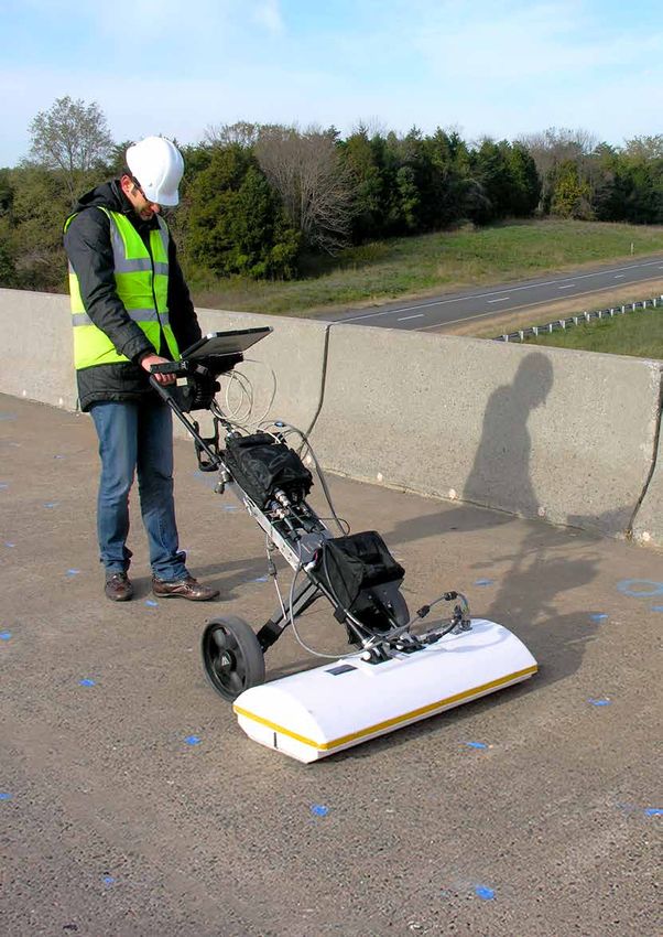
© Langeveld Cranes

                                       MEASURING HIGH
                                       IN PORTS
                                       Arno Kijzerwaard       Case Study

                                       Tracking accurate measurements for crane operations
                                       around the world

                     8 | Reporter 80
© Langeveld Cranes
In a world where cargo transportation                high on a moving steel structure in the wind. Not
by means of intermodal containers                    to forget one had to travel half the world to even
keeps growing in volume, ship sizes                  get there.
show a steady increase as well. As a
consequence, ports around the world                  The accurate alignment of trolley wheels on
have to invest in larger container cranes            container cranes is such a specialty and niche
in order to handle these ships.                      market that the market area is simply formed
                                                     by ports around world. Langeveld Cranes
These container cranes are increasing in operating   has almost a decade of development in this
speed as well as in their level of automation.       technique, bringing it to a whole new level. By
Trolley traveling speeds up to 240 or even           now, their estimated amount of successful
300 metres per minute are no exception anymore.      projects approximates 300 all over the world.
On a track of 100 m, these trolleys easily travel
more than 10,000 kilometres per year.                Langeveld has been using a Leica TS30 total
                                                     station and recently added a Leica Nova TS60
One of the key elements to crane maintenance         total station to its equipment basket. The
at these high speeds is the wear, caused by          TS60 is used in combination with a Leica CS35
the wheel-rail contact of the trolley. Effective     tablet computer and Langeveld’s own specially
prevention of this aggressive form of wear           developed wheel alignment software.
is realised by an accurate alignment of the
trolley wheels. On a container crane with a          WORKING IN THE EXTREME
girder height of more than 50 m, however, this
                                                     Tolerances for wheel alignment date back to
alignment procedure puts extreme demands on
                                                     the 1970s. Classic crane design standards
measurement instruments.
                                                     all specify maximum allowable wheel angles
STAYING ON TRACK                                     of 0.4 mm/m. This is, however, not quite the
                                                     same as describing good running behaviour. By
Though the alignment measurement of a set            approaching the alignment from the side of good
of steel wheels on steel rails seems a straight      running behaviour, a whole new accuracy level
forward activity that could be performed by          was achieved in the practical end result.
almost anyone in possession of a theodolite,
this proves far less simple when located 50 m

                                                                                                          Reporter 80 | 9
© Langeveld Cranes

                                        This new accuracy level, though beneficial,         working day. Still, extreme variations of ambient
                                        puts higher demands on the accuracy and             temperature are no longer theoretical values in
                                        reproducibility of the measurements. The total      this line of work.
                                        stations have to measure up to the demands
                                        over and over again. The work of Langeveld’s        “In every thinkable climate, all over the world,
                                        trolley wheel alignment is so much more             our Leica Geosystems total stations have
                                        accurate than ever specified in the history of      travelled to ports on almost all continents,
                                        crane standards. This in itself is one thing, but   and passed through the hands of custom
                                        it’s also significant that this result is always    officials in many countries in Africa, the
                                        achieved on a height of more than 50 m from         Middle East, Asia and South America,” said
                                        quay level on a moving crane in the wind.           Casper Langeveld, owner, Langeveld Project
                                                                                            Management. “No matter the form of transport
                                        Climate is another critical aspect to consider.     or the environmental conditions, these total
                                        The temperature working range of measurement        stations continue to work and provide us with
                                        equipment is usually one line in the data           the measurements we need. We are able to trust
                                        sheet. Hardly a difficult specification to meet     the results and ensure quality deliverables for
                                        when measuring close to Langeveld’s home            our clients.”
                                        base in the Netherlands. This becomes a less
                                        theoretical value, however, when winter projects    NEW TRENDS, NEW NEEDS
                                        in Scandinavia are asked for, followed by           Recent developments in crane automation have
                                        tropical destinations around the equator.           unexpectedly led to a complete new challenge.
                                        After dozens of these projects, the TS30            The classic crane driver was normally located
                                        total station has remained stable. Of course,       almost directly above his load. Every move,
                                        the instrument is acclimatised prior to each        shock and sound were immediately noticed and

                     10 | Reporter 80
© Langeveld Cranes
reacted upon. This could be anything between communication to the total stations for a
a radio call for a service engineer or, in a worst cohesive work environment.
case, a full crane stop.
“We trust Leica Geosystems’ overall robust
The recent trend of increased crane automation solutions for our business,” said Langeveld.
and remote control have effectively removed the “We make a strong team together for the crane
driver from the crane. This means that there is market.”
no direct witness for unusual shocks or noises
in the trolley behaviour anymore. Therefore,
the trolley must run smoother than ever before,
© Langeveld Cranes
because any deviation in sound or shock will
stay unnoticed for a far longer time.
Meeting the international demands and work
volume, the TS60 was an easy choice for the
firm as a natural successor to the TS30. With
ATRplus, the TS60 total station's ability to
remain locked on the target is maximised,
ignoring other distractions in the field, which
can be plentiful in a port.
As Langeveld’s own software runs on the TS60,
along with the possibility of also using Leica
Captivate 3D field software, this is a crucial
feature for the firm. This enables the internal
Reporter 80 | 11© Global Surveys
REFERENCE STATION
USER STRATEGIES
IN A TECTONIC
ENVIRONMENT
Penny Boviatsou Case Study
New Zelands's most extensive GNSS reference station
network with more than 70 stations nationwide
12 | Reporter 80© Global Surveys
Fault
Continental Crust Shallow earthquake
AUSTRALIAN PLATE
E
AT
PL
C
FI
NE
CI
ZO
PA
N
T IO
UC
BD
SU
Deep earthquake
Earthquakes are a response to the motion “Providing a real-time kinematic (RTK) correction
between tectonic plates. As two plates push service over the internet and RINEX files for post-
together at a steady rate, the rocks along processing, our customers can enjoy the benefits
the plate boundary become more and more of SmartFix,” said Bruce Robinson, director at
stressed until eventually something has to Global Survey Limited. “If their GPS or GNSS
give — an earthquake occurs along a fault receiver can connect to the internet, SmartFix
somewhere in the plate boundary zone. can deliver the data they need.”
New Zealand lies at the edge of both the EARTHQUAKES SHAKING UP NEW
Australian and Pacific tectonic plates. The ZEALAND
Australian and Pacific plates push against each
other along a curving boundary and generally New Zealand has two types of earthquakes.
don't move smoothly past each other. They move Deep earthquakes under North Island form
in a series of small rapid motions, each of which a well-defined band (seismic zone) running
is accompanied by earthquakes. northeast from Marlborough through White
Island. Shallow earthquakes tend to occur to the
SmartFix, based on the world’s largest reference southeast of this seismic zone, while the deeper
station network, HxGN SmartNet, is New ones occur towards the northwest.
Zealand’s most extensive GNSS reference
station network with more than 70 stations The New Zealand GeoNet, a partnership
nationwide. SmartFix delivers centimetre- between the Earthquake Commission (EQC),
level, real-time kinematic corrections, post- GNS Science, and Land Information New
processing solutions and sub-metre GIS Zealand, monitors all geological hazards in
corrections. HxGN SmartNet is an integrated the country, and locates between 50 and 80
24/7 GNSS network RTK and correction service, earthquakes each day – about 20,000 a year.
built on the world’s largest reference network, Earthquakes can occur anywhere at any time in
enabling GNSS-capable devices to quickly New Zealand.
determine precise positions. These earthquakes are continually altering the
shape of New Zealand and while a lot of the
Reporter 80 | 13600 mm/yr
© Global Surveys
TONGA-KERMADEC TRENCH
Australian plate
AUSTRALIAN PLATE
pulls East Cape area
Land on Volcanic Plateau is pulled apart southwards as it rides
and sinks as East Cape pulls away from over Pacific plate
Northland.
500 mm/yr
PUYSEGUR TRENCH
ault 400 mm/yr
f
pine Pacific plate moves west and
Al southwest by 30-60 mm a year and
dives under Australian plate
300 mm/yr
PACIFIC PLATE
200 km
movement is small and unfelt, it is continual and The New Zealand datum is known as NZGD2000,
the result is perceivable, measurable and locally and this datum is based on International
variable. The measurable and variable part is Terrestrial Reference Frame (ITRF) 1996 as at
what the reference station network SmartFix the position on the feature on January 1, 2000.
needs to deal with. Because the datum is deforming, NZGD2000
coordinates no longer reflect the true positions
There are many examples of rapid movements of points relative to one another.
that combine lateral and vertical movements.
Such movements are clearly not uniformed; The local area distortion, however, is small,
this variability creates challenges for those and for most applications, the deformation
who need to establish reliable survey control or can be and is ignored. This allow for distances,
those who run reference station networks. bearings and areas to be calculated directly
from NZGD2000 coordinates. This deformation,
INVESTIGATING EARTHQUAKE ACTIVITY however, needs to be continually addressed
Even though New Zealand is continuously and managed by the reference station
moving and deforming under the influence of administrators.
the Australian and Pacific tectonics plates, the The error in ignoring the variation is no more
country’s datum is designed to provide constant than one millimetre in a kilometre for each year
unchanging coordinates for features. since 2000. A deformation model is periodically
Datums define how coordinates, longitudes and applied to account for deformation due to
latitudes or heights, relate to physical locations. earthquakes, regarding calculating NZGD2000
Projections are different ways of representing coordinates, and as the measurement of the
a position in a datum, for example as northings deformation model becomes more accurate.
and eastings used on topographic maps. CHALLENGES WHEN RUNNING A
Together, they define New Zealand's coordinate REFERENCE STATION IN NEW ZEALAND
systems.
The NZGD2000 datum was set on January 1,
To manage this deformation, the datum itself 2000 – the last time everything fit together
is moving and deforming along with the New nicely. Since 2000, New Zealand has had
Zealand land mass – it is a “plate-fixed” datum. 17.5 years of differential movement, and while
14 | Reporter 80© Global Surveys
Ten years of shallow
earthquakes in New
Zeland
(Depths < 40 km)
Magnitude
M 7.0, 3rd September
the coordinates of the mark have not changed, used GNSS networks to save time and money as
the relative position has. A point surveyed well as remove potential sources of error.
today, from three different reference stations,
will likely have three different NZGD2000 Instead of carrying around:
coordinates dependant on the reference station
■■ GPS receivers
used.
■■ batteries and cables
“Education of clients is a major part of SmartFix ■■ two radios
administrator job here in New Zealand, as ■■ a tripod and a pole
we are upskilling users to understand the ■■ and setting up their own local base for
geodetic implications of station selection,” said each project,
Robinson.
network users simply carry a GPS or GNSS
The second challenge is obtaining and choosing smart antenna (rover) with an internal modem
the two coordinates for the reference stations or an external mobile phone and use that
that the Leica GNSS Spider reference station equipment to quickly access a network of
software requires. The two coordinates being permanent reference stations. The combined
the current epoch coordinates to ensure the data from those permanent stations is used to
reliability of the network and the NZGD2000 generate RTK corrections and provide accurate
coordinate. The GNSS Spider solution is positioning at much greater distances than
an integrated software suite for centrally traditional radio solutions.
controlling and operating GNSS reference
“At Survey Global we are committed to the
stations and networks and helping to manage
growth of the SmartFix (SmartNet) network,”
complex environments such as New Zealand.
said Robinson. “It enables our customers to get
A RELIABLE AND EFFICIENT SOLUTION reliable and repeatable NZGD2000 coordinates,
despite the tectonic challenges, and for the user
Using a network like HxGN SmartNet (SmartFix it makes them more efficient, allowing them to
in New Zealand) saves field crews time as it complete projects on time and on budget.”
precludes the setup of separate base stations,
and it avoids the risk of having control fail due
to a damaged or stolen base and removes the
issues of radio interference. Surveyors have long
Reporter 80 | 15© UAB SmartOffice
MODELLING FOR
MONITORING - WHEN
MILLIMETRES MATTER
Renata Barradas Gutiérrez Case Study
Collecting point cloud measurements to monitor a
hydroelectric plant in Lithuania
16 | Reporter 80Hydroelectric plants harness the power GOING HIGH TECH FOR DAM MONITORING
of flowing water; the most extensively
exploited renewable energy resource. Our To monitor KPSHP, UAB SmartOffice surveyed
daily activities and economies depend on the hydroelectric plant using the Leica Nova
a constant supply of electricity; hence, MS60 MultiStation to collect measurements
monitoring displacements and deformations and a point cloud of the structure. The 3D data
to prevent problems related with structural collected allowed UAB SmartOffice to analyse
failure, cracks or ageing material in the surface and calculate the verticality of the
hydroelectric plants is of vital importance. hydroelectric plant. The model generated with
the point cloud will also serve as a reference for
Pumped storage hydroelectric plants are one future scanning that will monitor the current
of the various ways of extracting energy from conditions and deformation of the dam.
water. The biggest hydropower energy sources
in Lithuania are the Kaunas Hydropower Plant “Scanning with Leica Nova MS60 MultiStation
and the Kruonis Pumped Storage Hydroelectric has brought more results than expected.
Plant (KPSHP). The KPSHP is a pillar for the Besides 3D scanning up to 1,000 metres, the
Lithuanian energy system that has been main benefits were time saving, accuracy and
successfully supplying energy to homes and simplicity,” said Jonas Varnas, general manager
businesses for more than 20 years. Located at UAB SmartOffice. “Using the MS60 was as
close to the city of Kaunas, this state-of-the-art simple as a routine using a TPS but combining
energy facility is the one of the biggest plants of the precision of TPS measurements and 3D
its type in the Baltic region. scanning into one system.”
This 900 Megawatts hydroelectric plant is With the MS60 MultiStation, complex sites can
designed to generate electricity, balance be surveyed with overlaid measured points and
consumption by regulating voltage, frequency 3D models in one view, allowing users to perform
and load fluctuations, and compensate energy verticality and deformation checks to identify
deficiency in case of an emergency situation. damage and defects in a more reliable, quicker
According to Lietuvos Energijos Gamyba, the and complete way. The 3D scan capability of the
KPSHP covers 6 per cent of Lithuania’s total self-learning MultiStation helps users expand
electricity demand and is capable of ensuring their portfolio of offered services, being able to
94 per cent of the total necessary energy be used for:
reserves for Lithuania in case of emergency –
■■ construction monitoring
a deformation in its structure can be fatal to
■■ quality inspection
Europe’s Baltic state energy system.
■■ clash detection
■■ as-built Building Information Modelling
(BIM).
Reporter 80 | 17© UAB SmartOffice
The KPSHP was monitored by geotechnical
sensors, so no geodetic equipment was used.
© UAB SmartOffice
In comparison to other sensor technologies
where deformation information is limited to
few points, the MS60 MultiStation provides the
ability to measure a dense amount of points and
provide the measurement of displacements in
relation to millions of points with overlaid TPS
measurements.
INSPECTING AND COMPARING SURFACES
What makes the Kruonis plant special is its
ability to operate in pump mode during periods
of low demand or as a traditional hydroelectric
plant to supply the normal energy demand
during the day.
These water level changes in the upper reservoir
of the dam can cause deformations. The
KPSHP authorities, therefore, were interested
in analysing the surface and verticality of the
dam, identifying places with deformation and
comparing the scanned model with the ideal
model.
3D Reshaper, an essential software for
surveyors working with point clouds, allowed
18 | Reporter 80© UAB SmartOffice
UAB SmartOffice to measure, inspect and
compare surfaces displaying deviation
information with millimetric accuracy. The
modelled surface generated from the point
cloud provided an accurate representation of
reality to detect millimetric changes in shape for
the entire structure.
“3D Reshaper allowed us to do the best shape
export, analyse the surfaces with several
integrated tools, and permitted our client to
inspect surfaces in a very clear way – exactly
what our customer was looking for,” said Varnas.
MONITORING MATTERS
In dam monitoring, millimetre precision is
required. The consequences of structural
deformations in these structures go beyond
multimillion costs. Consequently, deformations
should be discovered and monitored in a
timely manner to ensure a safe operation and
usage, and cost-effective construction and
management.
Reporter 80 | 19© Atkins
IMPROVING
THE RAILWAY
INFRASTRUCTURE OF
A CAPITAL CITY
Staff Case Study
Measuring for new rail lines in the United Kingdom
20 | Reporter 80With thousands of commuters into the capital ■■ 10 Captivate CS20 controllers
city every day, additional trains into London ■■ 2 Captivate CS35 tablet computers
are a plus to help with the heavy traffic ■■ 2 LS15 auto focus digital levels
congestion. ■■ 8 full traverse kits
As part of the Brighton Mainline Upgrade With the new portfolio, Atkins was ready to take
Programme, an additional six trains per hour on the important rail project.
will be made available during the morning
peak. Along with this, the programme would SITE LIMITS AND CHALLENGES
also see four additional services into London To enable the additional programme paths toward
with a further two additional trains in 2043. London Victoria and London Bridge, there was
Performance will also be improved through a requirement to segregate flows at Windmill
the segregation of flows and contribute toward Bridge Junction. It would support performance
additional train paths on the route. improvement on the route through the segregation
Topographical surveys are required for this of key train flows, which currently transfer
complex and extremely busy piece of London’s reactionary delays across the other adjacent lines
railway infrastructure. The programme provides and the wider South London network.
the ideal time to upgrade to newer, faster and To achieve additional train stopping capacity
more efficient solutions for data capture. at East Croydon, there was a requirement
Network Rail, the government entity in charge of for additional platforms to be constructed.
the programme, turned to Atkins to perform the In addition to safely delivering a 12-car train
surveys. operation between Selhurst and Gloucester
Road Junction, infrastructure was required to
A MAJOR UPGRADE accommodate a 12-car train on the Selhurst
Spur.
Established in 1938, Atkins is one the world’s
most respected design, engineering and project As a result, feasibility options were developed to
management consultancies. Working closely with achieve these outputs. The options include:
a wide range of clients from different sectors
and regions across the public and private sectors ■■ Grade separation of Windmill
and local and national governments, Atkins Bridge Junction
delivers long-term trusted partnerships to create ■■ Extension of the Selhurst Spur
a world where lives are enriched through the ■■ Additional track between Windmill Bridge
implementation of ideas. Junction and East Croydon
■■ Two additional platforms at East Croydon.
Atkins Rail Division, based in Croydon, Surrey,
United Kingdom, has been using Leica It was identified that work would be required
Geosystems surveying equipment for almost at East Croydon station to safely deliver the
20 years. The decision was made last year to required passenger access to new platforms and
replace the majority of the consultancy’s trusted provide sufficient increased passenger capacity
but aging fleet of Leica System 1100 and 1200 on the concourse.
total stations and to add to the firm’s existing
“As with all railway topographical surveys, the
GNSS, digital levelling and traversing equipment
limitations of site access and the nature of
with the latest Leica Captivate solutions.
railway infrastructure constrains the way we
This major upgrade saw a broad spread of conducted the survey,” said Matevz Groboljsek,
instruments: Atkins Track Team project manager. “This was
especially true on a project area of this scale
■■ 1 Nova MS60 MultiStation and considering the complex junction and train
■■ 7 Viva TS16i Imaging total stations routing available through the section of the
■■ 4 Viva GS14 GNSS Smart Antenna infrastructure.”
Reporter 80 | 21LEICA CAPTIVATE SOLUTIONS HELPING digital level with imaging and auto focus were
THE WORLD OF RAIL used, allowing for a faster, more accurate staff
reading in harsh conditions. The instruments
With accuracy and reliability paramount in were also used in conjunction with track trollies
the rail environment, Atkins turned to Leica and alongside Leica Geosystems laser scanning
Geosystems‘ solutions and technology to solutions.
avoid costly downtime during expensive and
time restrictive track possession. The latest The provision of topographical survey data and
innovations available within the new Leica selected point clouds for the project designers
Captivate range proved invaluable in this to use and develop created a rationalised railway
situation. infrastructure design that will increase capacity
on an already packed section of South London’s
The Leica Nova MS60 MultiStation, with its rail network. Ultimately this will declutter
wide spread of functionality including the historical track alignments, making them
ability to scan up to 1,000 points per second, suitable for rail expansion into 2020 and beyond.
was used on the project. Combined with the
imaging capability on all the total stations and The project and the data provided to it will lead
the interoperability of these with both the Leica to providing a better railway experience for
CS20 controller and CS35 tablet computer, the growing customer base and will be used to
this enabled Atkins to capture every necessary support economic growth of the surrounding
detail in the quickest and most effective way. areas.
The same controllers and Captivate software
were used with the GNSS Smart Antennae to
establish control quickly and accurately using
HxGN SmartNet correction service. Alongside
the Captivate software, the latest Leica LS15
22 | Reporter 80© Atkins
PROVIDING TOPOGRAPHICAL efficiency by assuring the quality of 3D GNSS
SURVEYS TO LONDON’S RAILWAY data directly in the field.
INFRASTRUCTURE
With intuitive and understandable software in
For Atkins, Leica Geosystems solutions have the field and in the office, Captivate allowed
brought many benefits to the project. instant 3D visualisation of the survey data
collected on the railway site, providing a detailed
“By adopting Leica Captivate software
understanding of the project requirements.
technology, we can provide Network Rail with
fast and accurate data realisation, avoid costly The Leica ScanStation P40 laser scanner also
returns, and save them time and effort, whilst offered a fast scan rate with less noise and
also reducing their risks,” said Groboljsek. clearer scans along with streamlined workflows
“By using a combination of Leica Geosystems from the field to office and back via easy
solutions, data was collected safely, accurately, automated processing with Leica Cyclone laser
efficiently and, above all, within limited time scanning software. This was then all quickly
during track access possessions. Reduction and easily communicated to all staff and to the
in time spent on the track reduced site-based client using Leica TruView.
risks and lessened risk of injury to Atkins
personnel. Also, there was a reduced risk to The Brighton Mainline Upgrade Programme
Network Rail property and infrastructure.” upon completion is one of the first where the
topographical survey was used much earlier
Primary and secondary control was established in the project lifecycle. Combined with Leica
using the fast and accurate Leica Viva GS14 Captivate solutions, the rail project is delivered
GNSS Smart Antenna, using both post smoothly allowing for the design team and
processed and live RTK data from HxGN surveyors to proactively manage and transmit
SmartNet. The service was also used to increase decisions based on immediate feedback.
Reporter 80 | 23© Paolo de Girolamo
THE CHRONICLE OF AN
ADVENTURE
Penny Boviatsou Case Study
ECO40 boat trip research to provide ocean
scientific information
24 | Reporter 80© Paolo de Girolamo
On October 19, 2014 Matteo Miceli, a famous
Italian oceanic sailor, left the Port of Riva di
Traiano located close to Rome, Italy, with the
Italian sailboat ECO40 for the Roma Ocean
World Project. His goal was to sail around the
world alone, without the help of any fossil
fuel or additional supplies, other than what he
brought with him for the entire 27,000 nautical
miles (50,000 kilometres) journey.
ECO40 is a Class 40 oceanic vessel (Length
overall of 12,0 metres) that was equipped with a
data acquisition system for both the met-ocean
parameters recorded on-board (i.e. apparent
and real wind speed and wind direction,
atmospheric pressure, current velocity, air
and sea temperature, etc.) and the kinematic
characteristics of the boat itself (i.e. speed and
course over ground). A team of professors from
the University of Rome and the Polytechnic Turin
recorded the boat’s movements by using three
Leica GR25 GNSS reference receivers. With
these they were able to:
■■ Calculate the height of waves along the
ECO40 route by using the boat as a buoy
and validate the numerical models of the Fortunately, the data were saved together with
United Kingdom - based Met the boat and the researchers were able to do the
(meteorology) office; final analysis of the journey.
■■ Improve the structural design of the Class
THE SAILOR’S JOURNEY
40 sailboat by means of calculating the
boat’s dynamic stress and boat material The planned route was the classic clipper
durability during the trip; route that runs from west to east through the
■■ Record the wave characteristics taken from Southern Ocean, taking advantage of the strong
the ECO40’s movements to produce a polar westerly winds. Namely the route consists in
diagram of the boat’s speed, which would passing the Gibraltar Strait, then in descending
be useful for future Class 40 racing boats. the Atlantic Ocean and sailing around the
Antarctic, at an average latitude of 50° S, from
Miceli transmitted the data via satellite for
west to east rounding the most famous capes
analysing to Professors Paolo De Girolamo
of the world: Cape of Good Hope, Cape Leeuwin
and Mattia Crespi of the University of Roma
and Cape Horn. Finally, sailing the Atlantic
La Sapienza and to Alessandro Pezzoli of the
Ocean back to the Strait of Gibraltar and come
Polytechnic Turin.
back to the homeport.
On his way back to Italy, after rounding the three
“The data collected by the Leica GR25 GNSS
capes and sailing for 25,000 nautical miles, the
receiver and the Leica AS10 antenna concerning
ECO40 capsized at the Equator. Matteo was
the movement of the boat reported that ECO40
about 600 miles offshore the Brazilian coasts.
sailed wave heights of roughly 6 metres during
He was saved by a cargo ship. When he came
the first storm with maximum waves reaching
back to Italy, he organised a first expedition to
10,0 m,” said Miceli. “After the end of the
try to recover ECO40, which was not successful.
trip, we are now able to calculate the exact
After a month, the expedition team tried again
measurements.”
and found ECO40 300 miles offshore the
Brazilian coasts. Now the vessel is back in Italy.
Reporter 80 | 25© Paolo de Girolamo
GATHERING THE DATA The two methods were used complementary in
order to obtain the boat motion, and the boat
A part of the measured data was sent to the land motion has been applied to estimate the waves’
team on daily basis by satellite modem. These properties faced by the sailboat during its
data, measured by the boat and transmitted navigation around the world.
almost in real time, helped significantly the
team in charge of the safety of ECO40; the Indeed, the first (i.e. variometric approach) was
knowledge of the actual weather conditions used to calculate the boat heave, surge and
the boat was really facing during the navigation sway motions, while the second one (i.e. moving
could improve the route strategy and increase base kinematic approach) was used to calculate
the boat safety. the roll, pitch and yaw motions. The wave
characteristics (i.e. directional wave spectrum)
“The measurements of the boat movements, were derived by using the heave, pitch and roll
obtained from the three GPS receivers, if motions.
properly analysed, can provide a measure of the
waves that the ECO40 encountered during the When fast movements have to be detected and
navigation,” said Miceli. their effects suddenly evaluated, Leica VADASE
can help researchers make the most informed
The three high precision Leica Geosystems GPS decisions immediately. The solution adds
receivers were placed on the left and right side additional value to traditional GNSS monitoring,
of the stern along the boat cross axis while the providing accurate velocity information
remaining one was placed close to the boat based on a stand-alone GNSS receiver that is
entrance along the boat’s main longitudinal axis. continually available in real time for precise and
The data were acquired by the system during reliable analysis of fast movements.
the navigation of the ECO40 and stored on a
flash-card by each receiver. The data analysis The boat performance data (i.e. speed and
was carried out in post-processing after the course over ground) can allow, after a certain
recovery of the flash-cards. amount of time that is required, to obtain a
statistically meaningful database, to estimate
Two different strategies were adopted in the the real polar velocity curves of the boat. Indeed
post-processing: these curves were used for the prediction of the
1. The “Variometric Approach for optimal route made by the land team by using
Displacements Analysis Standalone Engine” a route optimisation software, which was sent
(VADASE) daily to Miceli.
2. The moving base kinematic approach. The actual polar velocity curves of the boat
differ from the theoretical ones estimated by
26 | Reporter 80the designer of the boat. This is due to several
© Paolo de Girolamo
causes, among which plays an important role
the ability of the crew to “push” the boat to the
maximum of its performance and the presence
of waves that normally is not taken into account
when calculating the curves themselves.
These data are used mainly for two technical
and scientific purposes:
1. The first purpose is the calibration and/
or verification of the numerical models
output that are commonly used for the wind
and wave forecast and/or analysis into the
oceans, and the calibration of the remote
sensing data (e.g. satellite wind and wave
measurements).
2. The second purpose is directly related to
the vessel design. Indeed the knowledge of
both the movements and the loads that this
This comparison, along with the results of
kind of vessel can deal with, together with
the heeling analysis, showed that the wind
the response of the materials to the fatigue
measurement height plays an important role.
stresses, can improve significantly the
The corrected measurements of the wind are
design methods.
comparable with the results obtained from
ANALYSING THE MEASUREMENTS the numerical models: a good agreement
is noticeable within the first 60 hours.
This undertaking was the first time ever that a Nevertheless, a sensible discrepancy between
sailboat’s movement was accurately measured the measured wind data and the numerical one
by GNSS on a global journey and data were is noticeable as the storm peak occurs.
transmitted via satellite every few hours. In
terms of the met-ocean conditions and in terms The direct comparison between the forecast
of the boat heeling, the first violent storm and the measured wind speed showed, in
experienced by the ECO40 during its navigation the present case, as expected, relevant
occurred in the Gulf of Lion 21-22 October 2014. discrepancies. These discrepancies are such to
The heeling of the boat was estimated by using underestimate the forecast wind condition in
the GPS signals that were analysed by using a the order of 50 per cent of the forecast wind for
moving base kinematic approach. This analysis severe storm conditions.
allowed to estimate the heeling angle α during
The researchers and professors were able to
the whole storm event.
put together a research paper based on the
“Concerning the met-ocean conditions, we comparison between measured and numerical
analysed the storm on the basis of the wind data wind data.
that were measured and transmitted almost in
“Still, despite the unexpected end of the journey,
real time from the boat,” said De Girolamo.
the data collected from the Leica GR25 GNSS
Wind data were measured on board of the receiver and the Leica AS10 antenna were
ECO40 by means of an anemometer placed enough to provide ocean scientific information
on the top of the mast. The first comparison for the development of new ocean knowledge
was carried out with the European Centre for and technologies for the benefit of society,” said
Medium-Range Weather Forecasts (ECMWF) Frank Pache Senior Product Manager, GNSS
and the second one was carried out by using Networks and Reference Stations at Leica
the forecasted data, provided by the numerical Geosystems.
model GFS (Global Forecast System).
Reporter 80 | 27© Prashant Surveys
TRIPLE I: INNOVATION
IN INDIA
Amit Kumar Case Study
Highway surveying with mobile mapping in India
With increasing demand for readily available, challenging task, which needs lots of efforts and
consistent, accurate, complete and is practically difficult. Prashant Surveys were
current geographic information, geospatial able to conduct the surveys in one month using
applications have indeed become the primary the Leica Pegasus:Two mobile mapping platform
tool across the globe to access sophisticated and deliver the data from the surveys in one
geographic information. This transforms more month. The same project would have taken
raw data into actionable, authoritative more than one year to complete using traditional
intelligence. The fields and sectors deploying methods.
these technologies are currently growing at a
fast pace to unveil a smarter world. India is no With Leica Geosystems Pegasus:Two mobile
exception. mapping platform, though, this objective was
possible after some good training sessions and
Indian roads and buildings are ancient. hands-on experience. Prashant Surveys made
Grand Trunk Road was built across India in a substantial investment in the Pegasus:Two
1857 to connect developing civilisations like mobile mapping platform and reality capture
Harappa and Mohenjo-daro. The public works solutions, becoming the first company in India
department of the Maharashtra government to adopt this new technology. The firm was able
wanted to develop, maintain and improve the to capture this vast length with a scan speed of
road condition in India. The government and 1 million points per second, maintaining survey
the consultants turned to Prashant Surveys, a grade accuracy of less than 2 centimetres.
professional land surveying and mapping firm
based in Pune, India, specialising in 3D mobile “We see a huge technological jump for field data
LiDAR survey. acquisition from the traditional total stations
to the latest mobile mapping systems,” said
GOING MOBILE IN SURVEYING Prashant Alatgi, head of Technical and Business
Development of Prashant Surveys. “We could
Surveying is a vital part of the design and easily capture georeferenced, high density 3D
construction process. Carrying out topographic point cloud data along with quality photographs,
surveys for about 2,600 kilometres and with the average output of about 100 km per day.”
delivering data in about two months is a very
28 | Reporter 80OPENING NEW OPPORTUNITIES “With the Pegasus:Two mobile mapping solution,
not only are we seeing savings on the cost of
Prashant Surveys was tasked to conduct the
manpower, management and all indirect costs
highway surveys to:
associated, but there are also applications we
■■ support the development of cadastral can now enter we weren’t able to before,” said
records for all road side features and Prashant Alatgi. “The opportunities presented
build-up structures; by the technology even further the ROI on our
■■ widen existing state highways; decision to pursue mobile mapping solutions
■■ align and improve the existing highways; and have been well justified.”
■■ create profiles of existing roads, L-sections
and cross section of highway corridors.
© Prashant Surveys
Along with these standard surveying
results, Prashant Surveys also sees further
developments for the firm from mobile mapping
technology. As the reality capture solution
comes with several other features, there are
varied mobile applications that apply. For
example, the vehicle mounted mobile mapper
and above-and-below ground reality capture
enables urban and rail surveying for as-built
detection, deformation monitoring and more.
With trackable health monitoring features,
environmental studies can be undertaken.
Finally, with wearable reality capture in the
Leica Pegasus:Backpack, Building Information
Modelling (BIM) is also a possible application to
enter.
Reporter 80 | 29© Hexagon AB
SHAPING CHANGE IN
CONSTRUCTION WITH
HXGN SMART BUILD
Cathi Hayes Feature
Using a simple and robust platform to orchestrate
construction and infrastructure projects
Three major trends are disrupting SMARTER DIGITAL LAYOUT
construction today:
In addition, SMART Build ensures construction
1. Building Information Modelling (BIM) productivity and accuracy by synchronising 3D
2. Digitalisation with cloud models and layout points to robotic total station
3. Mobile simplification software with its Digital Layout module. This
lowers the BIM barrier for field teams and bridges
The building construction industries are the gap between office and field while meeting
ripe for ’right-sized’ technology solutions industry requirements of powerful, yet easy to use
with simple and intuitive interfaces, yet very field solutions.
powerful technology behind the scenes. HxGN
SMART Build is just that – a next-generation SMART Build enables intuitive model viewing in
construction management SaaS technology that a connected cloud environment that eliminates
layers schedule and cost progress tracking over the need for field teams to purchase and train
a 3D model for powerful 4D and 5D real-time on complicated desktop modelling software.
progress and cost deviation tracking. The result Construction digital layout points can be added
is well-informed, fast decisions that ensure directly to any model object, such as concrete
projects are delivered on budget and on time. footings where points may be added to end points,
mid points or centre points. A unique feature of the
30 | Reporter 80solution is the construction layout points’ ability to AN INTEGRATED APPROACH
inherit intelligence from the model. So even if the
model is not used in the field by layout teams, they The solution also extends beyond digital layout
still reap the benefit of model intelligence such as with the ability to plan and execute construction
concrete type, floor level, rebar size, etc. The user projects by combining models, cost and
selects the model attributes, as it is configurable. schedule in one integrated platform. Users can
track actual time and cost in the field in real
Models and layout points are exported or synced time and continuously compare to what was
with Leica Geosystems’ robotic total station field planned in the office.
software, such as Leica iCON build construction
software or Leica Captivate, for fast and accurate Hexagon is shaping change in construction with
layout. Robotic total station single-point quality HxGN SMART Build by leveraging contemporary
control or as-built points can be round-tripped cloud and mobile technologies to meet the
back into the SMART Build collaborative model needs of the evolving construction industry.
environment for visual comparison. When
For additional information, please visit
as-designed versus as-built deviations are
hxgnsmartbuild.com.
identified, issues can be logged in the SMART
Build web client, with iOS or Android apps for fast
and effective collaborative team resolution.
Reporter 80 | 31© Leica Geosystems
FROM THE SKY TO THE
GROUND – POSITIONING HEAVY
CONSTRUCTION MACHINES WITH
PRECISION
Karina Lumholt Feature
Precise positioning for machine control with
HxGN SmartNet in Denmark
Since the late 1990s, the heavy construction ■■ machine control
industry has increasingly benefitted from GPS ■■ surveying
technology to achieve highly accurate grade ■■ engineering
information to complete earth-moving jobs ■■ construction
quickly and precisely. ■■ agriculture
■■ utility surveys
Without a correction of the satellite signals ■■ archaeology
from a reference station with a known position, ■■ monitoring
a machine control solution’s GPS system would ■■ and many more.
have an accuracy only higher than a couple of
metres similar to an in-car navigation system. SMARTNET IN DENMARK
This is not accurate enough for the construction
industry that needs positioning precision down With a total of 57 reference stations, controlled
to a couple of centimetres. and approved by the Danish Geodata Agency,
HxGN SmartNet has the most extensive RTK
The machine control solutions therefore need network and ensures the best coverage across
to receive corrected signals using a technique the whole country. The 3D machine control
called Real Time Kinematics (RTK) from either solutions offered by Leica Geosystems Machine
a single RTK base station or an RTK network, Control Division use a correction signal from a
which is a network of permanent GPS and/or reference station or reference station network
GNSS receivers whose combined data is used to once every second.
correct transmissions errors from the satellites.
Customers subscribed to HxGN SmartNet
HxGN SmartNet is a worldwide RTK network receive a SIM card for the earth moving
service based on Leica Geosystems’ GNSS machine’s GNSS receiver that connects
technology. With easy access to precise automatically via the telephone network to
correction data, users experience the best the closest reference stations. This allows
availability, reliability and traceability using the machine operator to receive centimetre-
internationally recognised standards, together accurate coordinates from the satellites to his
with flexible and affordable subscription options. in-cabin panel.
Many professionals benefit from HxGN SmartNet
to efficiently complete their daily tasks, such as:
32 | Reporter 80“I depend 100 per cent on SmartNet in my daily SmartNet and provides information about
work. I receive the project drawings and use the atmospheric errors. Built to provide high-
Rover CG60 from Leica Geosystems to mark out precision and high-availability, signals affected
roads, wells, cables and so forth. I see instantly by solar storms are restored in a couple of
if there is something wrong, either with the minutes and users can follow the information
satellite coverage or with the SmartNet signal, about solar flares and ionospheric errors on the
which, by the way, happens very rarely,” said website.
Jakob Lind, surveyor at Søren Kristiansen A/S.
“Signals from the satellites can be affected by
A PRECISE POSITIONING NETWORK YOU trees or tall buildings, and even the time of the
CAN TRUST day can have an effect on the satellite coverage.
The 3D machine control solution gives users a
The automatic and precise positioning service warning on the panel if there is connection to
integrated into machine control solutions less than the required four satellites or if the
only requires a mobile data connection and RTK signals are too slow,” explains Christian
an acceptable internet connection. This 24/7 Hansen, responsible for the HxGN SmartNet
GNSS Network RTK and correction service, solution in Denmark. “In places with intensive
built on the world’s largest reference network, data traffic, for example in the vicinity of large
goes unnoticed by its users while it quickly educational institutions, the correction signal
determines precise positions. can be delayed. If the caused inaccuracy is
“I don’t really notice the correction service higher than 5 centimetres due to slow signals,
because it normally works automatically the system will automatically shut down.”
and very well. If I temporarily loose internet With several years’ of experience as a machine
connection, I receive a warning on the panel operator Rune Lodall, sales consultant for Leica
inside my machine,” said Thomas Petersen from Geosystems Denmark recalled, “10 years ago
Fuglsanggård A/S. the majority of construction companies used
This service continuously provides a highly- base stations on their job site, but today HxGN
available infrastructure and even offers SmartNet offers such precise data that it is
all customers a free text message service used for most projects, even for grading jobs
that reports if there is a problem with HxGN that require maximum accuracy.”
Reporter 80 | 33© NGHS
SEEING BEHIND TO
SAVE UP FRONT
Rosie Knox Case Study
Documenting construction progress through
imagery in the USA
Healthcare facilities provide critical services ■■ $1.5 billion in revenue for the local and state
while enhancing not only the economic economy
benefits to communities but also the quality ■■ $45 million in uncompensated care
of life of citizens. Hospitals, emergency care ■■ 12,000 full-time jobs throughout the region
centres and other medical establishments and state.
also present complex building challenges.
With this much growth, several new facilities
The Northeast Georgia Health System (NGHS), a have been added to the System. Multivista
not-for-profit community health system serving construction documentation solutions have
more than 1 million people in 18 counties been used on five of these projects since 2008.
across Northeast Georgia, USA, has undergone
unprecedented growth in the last decade. In just LOCATING THE INVISIBLE
one NGHS facility from 2015-2016 alone, more In the most recent project, NGHS used
than: Multivista’s Interior Exact-Built, Exterior Exact-
■■ 30,000 patients received care in the Built, MEP Exact-Built, and Interior Progression
Emergency Department photo documentation services on its 119-acre
■■ 4,100 patients stayed in one of the Braselton medical campus.
hospital’s inpatient units Enabling the facility management team to see
■■ 3,200 surgical procedures were performed. behind walls, ceilings, and even slabs eliminated
In 2015, NGHS generated more than: many unforeseen conditions and costs.
34 | Reporter 80You can also read