Enhancing the Scientific Value of Industry Remotely Operated Vehicles (ROVs) in Our Oceans - Ocean Science Consulting
←
→
Page content transcription
If your browser does not render page correctly, please read the page content below
METHODS
                                                                                                                                                 published: 15 April 2020
                                                                                                                                         doi: 10.3389/fmars.2020.00220

                                            Enhancing the Scientific Value of
                                            Industry Remotely Operated Vehicles
                                            (ROVs) in Our Oceans
                                            Dianne L. McLean 1,2* , Miles J. G. Parsons 1,2 , Andrew R. Gates 3 , Mark C. Benfield 4 ,
                                            Todd Bond 2,5 , David J. Booth 6 , Michael Bunce 7,8 , Ashley M. Fowler 6,9,10 , Euan S. Harvey 8 ,
                                            Peter I. Macreadie 9 , Charitha B. Pattiaratchi 2,11 , Sally Rouse 12 , Julian C. Partridge 2 ,
                                            Paul G. Thomson 2,11 , Victoria L. G. Todd 13,14 and Daniel O. B. Jones 3
                                            1
                                              Australian Institute of Marine Science, Indian Ocean Marine Research Centre, Perth, WA, Australia, 2 The UWA Oceans
                                            Institute, The University of Western Australia, Perth, WA, Australia, 3 National Oceanography Centre, Southampton,
                                            United Kingdom, 4 Department of Oceanography and Coastal Sciences, College of the Coast and Environment, Louisiana
                                            State University, Baton Rouge, LA, United States, 5 School of Biological Sciences, The University of Western Australia, Perth,
                                            WA, Australia, 6 School of Life Sciences, University of Technology Sydney, Sydney, NSW, Australia, 7 Environmental
                                            Protection Authority, Wellington, New Zealand, 8 School of Molecular and Life Sciences, Curtin University, Perth, WA,
                                            Australia, 9 Centre for Integrative Ecology, School of Life and Environmental Sciences, Deakin University, Burwood, VIC,
                          Edited by:        Australia, 10 New South Wales Department of Primary Industries, Sydney Institute of Marine Science, Mosman, NSW,
            Elva G. Escobar-Briones,        Australia, 11 Oceans Graduate School, The University of Western Australia, Perth, WA, Australia, 12 Scottish Association
      National Autonomous University        for Marine Science, Oban, United Kingdom, 13 Ocean Science Consulting Limited, Dunbar, United Kingdom, 14 Environmental
                   of Mexico, Mexico        Research Institute, University of the Highlands and Islands, Thurso, United Kingdom
                        Reviewed by:
                      Brennan Phillips,
       The University of Rhode Island,
                                            Remotely operated vehicles (ROVs) are used extensively by the offshore oil and gas and
                         United States      renewables industries for inspection, maintenance, and repair of their infrastructure. With
                      Thanos Dailianis,
                                            thousands of subsea structures monitored across the world’s oceans from the shallows
  Hellenic Centre for Marine Research
                      (HCMR), Greece        to depths greater than 1,000 m, there is a great and underutilized opportunity for
                 *Correspondence:           their scientific use. Through slight modifications of ROV operations, and by augmenting
                   Dianne L. McLean         industry workclass ROVs with a range of scientific equipment, industry can fuel scientific
               d.mclean@aims.gov.au
                                            discoveries, contribute to an understanding of the impact of artificial structures in our
                   Specialty section:       oceans, and collect biotic and abiotic data to support our understanding of how oceans
         This article was submitted to      and marine life are changing. Here, we identify and describe operationally feasible
          Marine Ecosystem Ecology,
               a section of the journal
                                            methods to adjust the way in which industry ROVs are operated to enhance the
          Frontiers in Marine Science       scientific value of data that they collect, without significantly impacting scheduling or
          Received: 12 August 2019          adding to deployment costs. These include: rapid marine life survey protocols, imaging
          Accepted: 20 March 2020
                                            improvements, the addition of a range of scientific sensors, and collection of biological
           Published: 15 April 2020
                                            samples. By partnering with qualified and experienced research scientists, industry
                              Citation:
           McLean DL, Parsons MJG,          can improve the quality of their ROV-derived data, allowing the data to be analyzed
     Gates AR, Benfield MC, Bond T,         robustly. Small changes by industry now could provide substantial benefits to scientific
     Booth DJ, Bunce M, Fowler AM,
             Harvey ES, Macreadie PI,
                                            research in the long-term and improve the quality of scientific data in existence once the
             Pattiaratchi CB, Rouse S,      structures require decommissioning. Such changes also have the potential to enhance
           Partridge JC, Thomson PG,
                                            industry’s environmental stewardship by improving their environmental management and
    Todd VLG and Jones DOB (2020)
        Enhancing the Scientific Value      facilitating more informed engagement with a range of external stakeholders, including
       of Industry Remotely Operated        regulators and the public.
      Vehicles (ROVs) in Our Oceans.
                 Front. Mar. Sci. 7:220.    Keywords: subsea infrastructure, biodiversity, ocean observation, underwater technology, science-industry
     doi: 10.3389/fmars.2020.00220          partnerships

Frontiers in Marine Science | www.frontiersin.org                                  1                                                   April 2020 | Volume 7 | Article 220
McLean et al.                                                                                                          Enhancing Industry ROVs for Science

INTRODUCTION
Advances in underwater technology have promoted increasingly
comprehensive studies of our oceans and exploration to depths
previously out of reach of humans (Marsh et al., 2013; Katija et al.,
2017; Robert et al., 2017). A vast array of different underwater
technologies now exists and are used, often for different purposes,
by marine scientists and industries. However, oceanic scientific
research, especially that conducted in the deep sea, remains costly
in terms of logistics, personnel, and hardware, and restrictive
spatially in terms of access to remote locations (e.g., Jones et al.,
2013). The health of our oceans and sustainability of human
activities therefore increasingly relies on the development of new
technologies and cross-sector partnerships (Visbeck, 2018).
    The offshore petroleum (oil and gas; O&G) and renewable
energy industries routinely use underwater technology for
observation, control, and maintenance of infrastructure in
locations otherwise unavailable to marine scientists (Jones, 2009).
These activities increasingly use remotely operated vehicles
(ROVs), with over 550 industry workclass ROVs in operation
globally (IMCA, 2015; Figure 1). The numbers of heavy-duty
ROVs available to the scientific community is dwarfed by those
utilized by industry, particularly the O&G sector. Moreover,
industrial ROVs often remain at the same location for months to
years whereas scientific systems deployed from a research vessel
typically spend only a brief time at each study site. Annually,
offshore industries invest billions of dollars collecting thousands
of terabytes of data from ROVs, with much of these data
archived within the companies involved and findings sequestered
in commercially sensitive reports. These data remain an untapped
resource, to investigate questions regarding the structure and               FIGURE 1 | Images of industrial ROVs photographed by the authors.
                                                                             (a) Subsea 7 work-class ROV (∼2 m tall) being deployed from the Transocean
function of offshore ecosystems, well beyond the purposes of
                                                                             Jack Bates semi-submersible drilling rig. (b) Subsea 7 Centurion work-class
their initial collection (Gates et al., 2017a; Macreadie et al.,             ROV (∼2 m tall) on the MV Nordica. (c) Close up of Schilling Robotics Conan
2018). Consequently, industry-science partnerships that enable               7-function ROV manipulator (∼1 m tall as imaged). (d) Oceaneering Minimum
scientists to utilize and augment industry ROVs, and access                  Plus observation-class ROV (∼50 cm tall). (e) Detail of Oceaneering Magnum
collected data, have very high intrinsic value.                              ROV (∼2 m tall) showing video and still cameras on pan-and-tilt unit (center)
                                                                             and lights. (f) Underwater image of Oceaneering Millennium ROV (∼2 m tall)
    Industry is facilitating scientific research by providing ROV
                                                                             taking push core samples of the seabed at around 1,700 m deep offshore
video that was originally collected purely for asset-maintenance             Tanzania (taken with another ROV).
purposes. Scientists utilize these historical industry ROV data
to better understand the impact (both positive and negative)
that the large numbers of static structures in our seas (offshore
installations, including jackets, pipelines, wells, mattresses, etc.)       whereas for assessments of fish populations greater setback from
have on marine ecology (Macreadie et al., 2018; McLean et al.,              the structure is necessary for abundance counts. Industry ROVs
2018; Todd et al., 2018, 2019) and how this changes with                    usually operate on a 24-h schedule, and on an “as-required”
time (McLean et al., 2017; Thomson et al., 2018). However,                  basis and as such their timing may bias observations, particularly
the extent and nature of industrial ROV operations is often                 abundance estimates for species that exhibit diel and/or seasonal
not ideal for scientific analysis. For example, video resolution            changes in behavior and population dynamics (Barker and
is frequently too poor, and illumination often too low, for                 Cowan, 2018; Bond et al., 2018a). Once imagery is obtained from
species-level identification. As a result, data obtained from images        industry, further challenges can be faced in video formatting
are typically qualitative and descriptive, with identification to           for photogrammetric analysis and in spatially linking video to
imprecise levels well above species. Even if raw video is of                specific infrastructure components. For example, many industrial
high-definition (HD) resolution, it is often downgraded to low              ROVs operate without ultra-short baseline (USBL) navigation
resolution via down-sampling or compression to save archival                systems that allow the ROV’s position to be recorded in time and
space. Further, the distance of the ROV from the structure                  space and such information needs to be permanently tied to the
can limit its usefulness for identification of species. Close-              video records if maximum value is to be obtained from the latter.
up imagery of epibenthic organisms that often form complex                  There is an opportunity for these issues to be managed and for
“marine growth” habitats on offshore structures is required,                industry to obtain ROV video and associated metadata for their

Frontiers in Marine Science | www.frontiersin.org                       2                                                 April 2020 | Volume 7 | Article 220
McLean et al.                                                                                                    Enhancing Industry ROVs for Science

operational needs, while also providing useful data for research.          prerequisites for accessing offshore O&G installations. Moreover,
This requires industry to understand what scientists need, and             500 m shipping-exclusion zones around many installations
how scientifically useful their ROV video can be. Conversely,              prevent outsider access. As a result, academic scientists are often
marine scientists need to understand better the operational                precluded from accessing offshore assets, necessitating use of
practices of offshore industries if sensible proposals are to be           industry scientists and/or contractors to collect data. In these
made about changes to ROV operations. Such a bidirectional                 instances, academics can work with industry to develop succinct
understanding will enable industry to adapt future inspection              equipment operation instruction manuals or standard operating
campaigns to enhance the collection of both industry-relevant              procedures and can perform trials to determine where difficulties
and scientifically useful video.                                           in execution may occur. Consideration must be given to the
    Offshore O&G structures used by industry have finite                   expectations of ROV operators and industry partners if scientific
operational lives dictated by factors such as the size of underlying       data collection is to succeed and, in this regard, initial planning
hydrocarbon reserves and mechanical lifetimes. Thousands of                meetings and ongoing communication are essential.
structures will require decommissioning globally over coming                   A key role for ROVs in offshore drill-support operations
decades, with decommissioning activity already increasing                  is subsea asset integrity inspection. Such inspections provide
rapidly in some regions (e.g., North Sea; Fowler et al., 2018). Data       an opportunity to document marine life growing on or living
provided by ROVs will be essential for timely investigation of             in close association with structures. Dives are performed
the ecological role of offshore infrastructure and to predict the          regularly to inspect riser pipes, blow-out preventer (BOPs)
environmental effects of their removal/abandonment. Further,               and wells. Following such routine dives, ROVs are often
improved understanding of how marine communities are                       on “standby,” which presents an opportunity to perform
utilizing artificial structures can, and should, influence future          scientific observations, at little to no extra cost to the client.
structural design and installation to maximize environmental,              Conversely, when ROVs perform “as found” seabed surveys
social, and economic benefits. For example, the midwater                   on arrival at a new location, collection of scientific data
sections of platforms off California provide important habitat             during this period, while desirable, can cause delays to the
for the recruitment of fishery-important rockfishes (Sebastes              start of operations, with unacceptable financial implications
spp.), which then move to deeper platform sections as they                 for the operator. However, where operators can look ahead
mature (Love et al., 2006). Increasing the surface area and                at ROV schedules and include budget and time for dedicated
complexity of midwater structure in the design of future offshore          science data collection into ROV campaigns, the resultant
energy installations would likely enhance fish production at               higher quality data can better inform environmental impact
such sites (Claisse et al., 2014). In this regard, ROV imagery             studies, decommissioning decisions and improve scientific
of infrastructure is required to quantitatively measure structural         understanding – a win-win for science and industry. For example,
features, associated marine life and to reveal relationships               by collecting quantitative data on the conditions around a
between them. Understanding the drivers of fish populations and            site prior to, and during drilling, an operator and regulatory
fish biomass “production” would also assist Operators “design for          agencies will have a much better baseline from which to
decommissioning.”                                                          assess changes to the environment due to routine activities or
    This paper identifies and describes operationally feasible             serious accidents.
ways to adapt and augment routinely performed industry ROV                     In circumstances where ROV data collection cannot be
operations to improve the use of industry-obtained data for                completed independently by industry, researchers and industry
science (Figure 2). Use of ROVs by scientists independent of               could benefit from recent improvements in interactive video
industry is not discussed here; however, lessons learnt from the           conferencing, which may allow researchers to interact with ROV
use of science ROVs are relevant and have informed methods                 pilots and guide ROV surveys remotely, thereby avoiding the
described herein. This paper is prepared by research scientists            cost and safety risks associated with visiting offshore installations.
with the view to ensuring that suggested future modifications to           This model has been used effectively by scientific dives from
industry ROV operations are operationally feasible to implement            the NOAA ship Okeanos Explorer where telepresence is used to
and unlikely to significantly impact on scheduling and costs.              enhance a small on-ship science team by communication with
                                                                           dozens of onshore experts during each ROV dive (Hoeberechts
                                                                           et al., 2015). The Inner Space Center is another example where
ALIGNING EXPECTATIONS FOR                                                  telepresence is used to facilitate ocean exploration1 . Internet
SCIENCE-INDUSTRY COLLABORATION                                             access and bandwidth offshore are often limiting factors, and in
                                                                           the case of rig-moves, completely absent (i.e., no communications
Strong partnerships between industry and academic scientists:              when satellite dishes are removed temporarily), so this level of
i.e., relationships between project managers, engineers, industry          communication is often not possible. If bandwidth is limited,
scientists, and ROV operators are essential for successful                 latency may also present a challenge for remotely directed surveys
collaborative projects. This is in part because a suite of specific,       because organisms of interest may not appear at the offshore and
costly training courses and requirements (e.g., helicopter                 remote sites simultaneously.
escape safety training and offshore medicals, Federal security
clearances), coupled with prior offshore experience and
strict client Non-Disclosure Agreements (NDAs) are often                   1
                                                                               http://innerspacecenter.org/

Frontiers in Marine Science | www.frontiersin.org                      3                                            April 2020 | Volume 7 | Article 220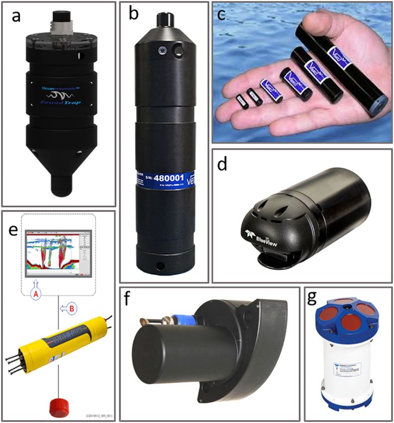
McLean et al.                                                                                                                         Enhancing Industry ROVs for Science

  FIGURE 2 | Industrial remotely operated vehicles (ROVs) can be enhanced to collect scientific information through the addition of (a) high definition video and still
  photograph cameras; (b) sediment core samplers; (c) Niskin bottle water sampler; (d) passive acoustic monitoring; (e) acoustic telemetry tags and receivers;
  (f) echosounder; (g) forward-looking multibeam; (h) Acoustic Doppler current profilers (ADCP); (i) mapping multibeam. Diagram not to scale.

AUGMENTING INDUSTRIAL ROVs FOR                                                           specifically for use in hydrocarbon-rich locations. These costly
SCIENCE                                                                                  types of modifications are made at the manufacturing stage,
                                                                                         with a consequence of longer manufacturing lead-times, and
Industry ROV inspection activities include visual surveys but                            good forward planning. Pressure housings must be rated to the
may also involve the use of manipulators to operate valves,                              maximum depth of the offshore site with a safety factor. Such
changeover components, conduct cutting operations, and clear                             considerations are hitherto unforeseen hurdles to overcome for
marine growth and debris (for example discarded fishing nets)                            the scientific community, who are not subject to these types of
(Figure 1 and Table 1). Inspections are often undertaken                                 environments and associated restrictions. Consequently, good
annually but can be more or less frequent depending on                                   communication regarding additional scientific requirements
the risk level and maintenance requirements. There is an                                 is required long before any actual modified ROV reaches
enormous opportunity to use and augment these capabilities to                            its final deployment destination. Nevertheless, the scope
facilitate ocean research on both temporal-spatial scales, without                       for augmentation is considerable and such factors can be
compromising routine O&G operations (Figure 2). A summary                                accommodated via close liaison with offshore operators (e.g.,
of augmentation approaches, the data they collect, and their                             McLean et al., 2019).
feasibility are presented in Table 1.
   All offshore industry instrumentation is subjected to rigorous                        Enhanced Imaging Techniques
risk assessment and must meet additional safety standards (e.g.,                         To facilitate accurate identification of fish, marine growth and
explosion-proof). Any additional scientific instrument payload                           other fauna, ROVs should collect at least HD video. Traditionally,
must be assessed for snagging hazard and stability testing.                              industry ROV operations do not require collection of HD
Further, if a standard industry ROV destined for a gas production                        imagery and, as a result, analysis of historical imagery for
platform survey is carrying any form of modification, such                               science is hampered by difficulties in species identification and
as additional cameras, all instruments must be pre-approved                              counting due to low image resolution (e.g., Bond et al., 2018a;
as “gas safe,” i.e., a non-source of ignition; consequently, the                         McLean et al., 2018; Thomson et al., 2018). Most modern ROVs
O&G industry utilizes custom-made technology that is designed                            possess the ability to record HD imagery and should do so as

Frontiers in Marine Science | www.frontiersin.org                                    4                                                   April 2020 | Volume 7 | Article 220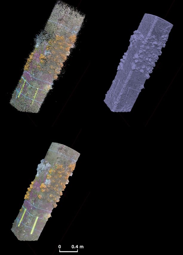
Frontiers in Marine Science | www.frontiersin.org
McLean et al.
TABLE 1 | Key environmental indicators for assessment and the approach for obtaining them using industry ROV.
Indicator Approach for measurement using Feasibility References to support
industry ROV industry use
Bathymetry, seabed fabric and ROV mounted sonar Low: Sector scanning sonar used as standard for navigation but not routine logging of data. Orange et al., 2002; Elvander
structural mapping ROV-mounted multibeam used in some scientific applications. Typically done using and Hawkes, 2012; Allotta
alternative approaches by industry. et al., 2015; Williams et al.,
2016; Baran et al., 2017
Seabed appearance ROV photography / video High: Regular use of imagery for real-time visual characterization during routine inspection. Gates and Jones, 2012; Jones
Imagery regularly recorded. Standard approach for industry. Requirement for HD imagery. et al., 2014
Sediment physicochemistry e.g., ROV sample collection (push cores / Medium: Use of sediment sampling equipment is straightforward but not standard. Gates and Jones, 2012
particle size, sediment chemistry Ekman grabs) Depends on industry operations. Requires scientist to direct and process samples.
Seabed currents Use ROV to deploy and recover current High: Instrument is deployed at the seabed using the ROV and recovered subsequently. Salim et al., 2018
meters Duration of deployment depends on time occupied at the station for ROV operations and
could be up to 1 year.
Water column properties Water samplers (Niskin bottles) Low: Water column sampling is straightforward and routine on scientific ROVs. It is rare on –
attached to ROV industry operations and equipment is not standard. Requires scientist to direct and process
samples.
CTD attached to ROV High: Instrument attached to ROV collects data whilst submerged. Data collected internally Gallager et al., 2004
and only requires an operator switch on/off before and after each dive. Some industry ROVs
have built in CTD’s but data extraction can be difficult. Additional sensors for chlorophyll,
5
turbidity, dissolved organic carbon and dissolved oxygen are possible.
Water column fauna In situ video/still observations, including High: Quantitative mid-water video transects. Often serendipitous encounters with larger Benfield et al., 2009, 2013;
stereo-camera animals. Benefits from additional oceanographic sensor data collection. Benfield and Graham, 2010;
Hoving et al., 2013; Phillips
et al., 2015; Jones and Pugh,
2018; Kupchik et al., 2018
Downward or horizontal-looking Medium. Use of scientific-rate echosounder equipment is straightforward, but not standard. Stanley and Wilson, 2000;
echosounders (e.g., mounted on In situ calibration is an issue. Data can be post-processed. Rose et al., 2005; Wilson et al.,
structure) 2006; Fujii and Jamieson, 2016
Deployed ADCP/Upward-looking Medium: Drilling operations often deploy ADCP for hydrographic assessment. Data rarely Osborne et al., 1977; Scotti
echosounder shared with scientists. Challenges with appropriate calibration for scientific requirements. and Pineda, 2004; Jones et al.,
Additional sensors can be added. Deployment of echosounder is similar to that of ADCP. 2006; Li et al., 2009
Calibration is a potential issue. ADCP for current measurements are more common.
Acoustic telemetry High: Potential for ROV to carry receiver unit and opportunistically detect tagged fauna or Heupel et al., 2015; Hussey
Enhancing Industry ROVs for Science
carry and an acoustic tag and provide opportunistic performance testing. ROV can deploy et al., 2015; Thums et al.,
acoustic receivers along maintenance routes or in dedicated trips to produce an array. 2016; Wilson et al., 2018
April 2020 | Volume 7 | Article 220
Epifauna (epigrowth) abundance and ROV photography/video High: Subsea structure inspection is routinely carried out using industry ROV. Many Guerin et al., 2007; Lebrato
composition examples of scientific study of routine pipeline inspection video. This can provide and Jones, 2009; McLean
information about background faunal assemblages, oceanographic processes and the role et al., 2017, 2018; Bond et al.,
of artificial structures. 2018a,d; Thomson et al., 2018
(Continued)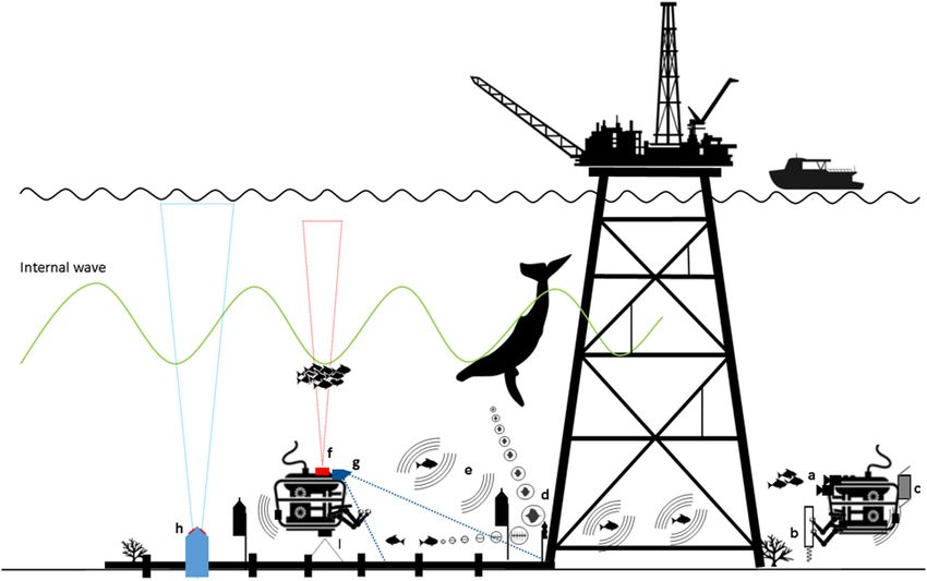
Frontiers in Marine Science | www.frontiersin.org
McLean et al.
TABLE 1 | Continued
Indicator Approach for measurement using Feasibility References to support
industry ROV industry use
Specimen collection Low: Collection of specimens from structures can enhance quality of studies of artificial Gates et al., 2019
structures by improving identification of organisms, identifying associated organisms and
measurement of biomass.
Epibenthic megafauna abundance and ROV photography / video High: Modification of routine as-found surveys can provide information on the pre-drilling Gates and Jones, 2012; Jones
composition seabed appearance. Scientist-directed ROV video transect surveys provide information et al., 2013
about background faunal assemblages and how they change following anthropogenic
impacts
Specimen collection Low: Collection of specimens provides improved identification of poorly known fauna. This Horton and Thurston, 2015
is particularly valuable in deep or other poorly explored areas where many species may be
undescribed species.
Microbial/Infauna abundance and ROV sample collection (push cores / Low: Use of ROV sediment sampling equipment is straightforward but not standard. Nguyen et al., 2018
composition Ekman grabs) Sample collection is time-consuming and there is a requirement for processing at sea so
needs scientist on board. Ability to collect these data depends on industry operations.
Marine mammal abundance and Video assessments Medium: Real-time ROV observations are unlikely to be a good way of observing marine Todd et al., 2016
composition mammals, owing to behavioral modifications.
ROV-deployed hydrophones/ PAM Medium: Installation or carrying of PAM is feasible but may be complicated by industrial Todd et al., 2009, 2016; Erbe
noise in active areas and recovery of long-term moorings in inactive areas. Linking between et al., 2015
industry and science can alleviate recovery of long-term moorings through the use of
acoustic release systems.
6
Multibeam/imaging sonar Low: Imaging sonar systems can detect “targets” at greater ranges than visual techniques, Becker et al., 2013; Parsons
reducing effect of ROV presence and noise; however, target identification is limited. et al., 2013, 2014; Lieber et al.,
2015
Fish abundance, behavior and Archive (historical) video of structures High: Use of historical video imagery of structures to quantify associated fish. McLean et al., 2017, 2018;
composition Bond et al., 2018a; Thomson
et al., 2018
ROV video in routine operations or drill High: Fish surrounding drilling operations can be documented during chance encounters or Laurenson et al., 2004; Pradella
support standby time targeted video transect surveys. et al., 2014
Mid-water photography/video Medium: Deployment of bait to attract necrophagous species. Benfield et al., 2008; Phillips
assessment et al., 2015
Deployment of standalone camera Low: Standalone camera for time-series observations. Gates and Jones, 2012; Gates
et al., 2017b
ROV deployed hydrophones/ Passive Medium: In situ observations of fish are complicated by ROV and industrial noise. Rountree et al., 2002, 2003;
acoustic monitoring Behavioral effects from ROV presence and noise are similar to that of video and sonar Erbe et al., 2015; McCauley
Enhancing Industry ROVs for Science
observations. Installation or carrying of PAM is feasible but may be complicated by industrial and Cato, 2016; Parsons et al.,
April 2020 | Volume 7 | Article 220
noise in active areas and recovery of long-term moorings in inactive areas. Linking between 2016; Todd et al., 2016
industry and science can alleviate recovery of long-term moorings through the use of
acoustic release systems.
Acoustic telemetry High: Potential for ROV to carry receiver unit and opportunistically detect tagged fauna or Topping and Szedlmayer, 2011;
carry and acoustic tag and provide opportunistic performance testing. ROV can deploy Piraino and Szedlmayer, 2014;
acoustic receivers along maintenance routes or in dedicated trips to produce an array. Froehlich et al., 2019
For each approach, feasibility is assessed and references to existing studies provided.McLean et al. Enhancing Industry ROVs for Science
structures (Bond et al., 2018b,c). Stereo imagery also enables
three-dimensional (3D) modeling of the environment which
is important for describing both structures and marine
growth, quantifying biological volumes, volumetric changes, and
biological growth rates (Harvey and Shortis, 1995; Shortis and
Harvey, 1998; Abdo et al., 2006). 3D HD video cameras have
been developed (e.g., Oceaneering Ocean ProHD 3D imaging
system) to provide the pilot with depth perception; however,
these cameras also allow precise measurements of marine life
to be performed. The addition of parallel lasers separated by a
known distance (either point or line generators) is a simple and
relatively inexpensive means of adding measurement capabilities
to industrial ROVs. Such enhancements provide utility to the
operator as well as for science.
The bright lights and loud sound produced by electro-
hydraulic ROVs may bias some surveys in favor of those taxa
that do not actively avoid the vehicle. Under such circumstances,
it may be useful to dim lights or equip the ROV with red-
filtered lights. Widder et al. (2005) showed that an ROV equipped
with red light was much less disruptive than white light for
observations of deep sea sablefish (Anoplopoma fimbria). By
shutting down the hydraulic pumps on an industrial ROV and
using red-filtered lights, Benfield et al. (2019) were able to
document the presence of additional fish species around a Gulf of
Mexico rig that had not been detected during surveys with white
lights while the ROV was running. Although additional lights and
specialist cameras have proven value, careful consideration must
be given to the location of such instruments added to an ROV to
avoid interference with ROV operations, impacts of the ROV on
FIGURE 3 | Examples of how ROVs can be utilized to collect scientific the recordings made by added instruments (e.g., sound/lighting
information; (a) deployment of Oceaneering Magnum ROV holding a interference) and equipment damage.
time-lapse camera system (to the right of the image) in 5-function manipulator
arm, (b) modified zip pump for collecting fragile organisms (sea urchin
pictured) suction tube attached to 5-function manipulator arm, (c) use of the
Acoustic Transmitters and Receivers
7-function ROV manipulator arm to collect specimens; (d) sediment core Industry ROVs are well suited to carry and/or deploy certain
samplers, (e) deploying small traps to collect specimens (red scavenging types of acoustic sensors, which are extremely useful tools to
isopods pictured), (f) bait cage and light traps to attract and capture census marine life on multiple spatial scales (Rountree et al.,
organisms, (g) mounted stereo-video cameras to collect high definition
2003; Koslow, 2009; Richardson et al., 2013; Hussey et al., 2015;
imagery (h). (i) DOF Subsea ROV fitted with Niskin Bottles (indicated by
arrows) from the Sydney-Kormoran Project Expedition 2015 provided Figure 2). Data acquisition is often autonomous, long-term, and
courtesy of Curtin University and WA Museum©. WA Museum (j) ROV non-interactive. Sensors can be mounted on ROVs or deployed to
recovery of a current meter from the seabed at 375 m, after Salim et al. (2018). infrastructure or the seafloor and retrieved/redeployed on up to
an annual basis (dependent on battery size, storage capacity, and
recording schedule), to collect near-continuous temporal datasets
standard practice. Although the acquisition of HD imagery is at minimal effort (Table 1).
relatively straightforward, storage of HD data and its handling Passive acoustic monitoring (PAM) sensors (Figure 4A) can
can add a significant indirect overhead and cost (see section be carried or deployed by ROVs to monitor environmental
“Data Management”). noise around O&G activities (Todd et al., 2009; Todd, 2016),
Additional video and digital still cameras can be mounted to detect vocalizing marine fauna (see section “ROV Acoustic
onto workclass ROVs for the specific purpose of collecting HD Surveys of Infrastructure and Surrounding Environments”) or to
imagery that facilitates scientific research (McLean et al., 2019; evaluate ecosystem changes evident in the soundscape (Gordon
Figures 2, 3G,H and Table 1). For example, McLean et al. (2019) et al., 2018) but the ROV’s acoustics signature may sometimes
recently added a compact stereo-video system onto a workclass interfere with such uses. ROVs can more easily be used to
ROV to collect HD imagery and enable accurate measurement carry acoustic telemetry receivers (Figure 4B) to detect marine
of organisms’ size. An ability to accurately measure size is fauna with attached or implanted acoustic tags (Figure 4C)
particularly useful for assessing biomass, life-history stages of and help understand how these animals (e.g., whale sharks)
organisms and their ontogenetic shifts in habitat usage (Elliott may use infrastructure (Topping and Szedlmayer, 2011; Piraino
et al., 2017), as well as the potential value of recreationally and Szedlmayer, 2014; Froehlich et al., 2019; Table 1), which
or commercially important fish species associated with offshore may have consequences for decommissioning. The previously
Frontiers in Marine Science | www.frontiersin.org 7 April 2020 | Volume 7 | Article 220McLean et al. Enhancing Industry ROVs for Science
potential behavioral bias their presence may induce (Spanier
et al., 1994). Some acoustic-related activities may require
dedicated ROV time and the presence of a specialist to initiate
these activities (e.g., range-testing telemetry arrays, programming
recording schedules, calibrating echosounders) and in extreme
cases (multibeam hydrography or water column) a specialist
operator for data acquisition.
ROVs as in situ Samplers
Industry ROVs are well equipped to take samples of sediments
and organisms from structures, the water column and the
seafloor (Figure 1C) but may require additional equipment to
store collected samples. Many workclass ROVs are equipped
with a 7-function manipulator arm, which is dexterous and
capable of precision sampling. Science-class ROVs (e.g., ROV
Jason, ISIS, Holland) and human occupied vehicles (e.g., the
Alvin submersible) typically use the same or similar 7-function
manipulator arms (Figure 3C). Industry ROVs tend to also be
equipped with a 5-function manipulator (Figures 3A,B), which
is of less value in precision sampling, but can be used to hold
sampling equipment. These arms can be used to either directly
pick up robust objects or to hold specific tools for precision
sampling, particularly for the collection of sediment or marine
FIGURE 4 | Examples of acoustic instruments that can be attached to, or biological specimen samples.
deployed by an industry ROV to collect scientific information including The collection of marine specimens can aid identification of
(a) OceanInstruments SoundTrap ST300 (PAM recorder), (b) Vemco acoustic
organisms and provide specimens for other biological studies.
telemetry receiver, (c) acoustic telemetry tags (Images courtesy of VEMCO,
part of Innovasea), (d) Blueview M900-2250 imaging sonar (Images courtesy
While some species are possible to identify from video, many
of Teledyne BlueView), (e) Simrad WBAT echosounder, (f) Norbit Subsea require detailed examination of features that are not visible
WBMS multibeam echosounder (for seafloor and water column), (g) Teledyne from images, for example because of orientation or resolution
RDI ADCP (acoustic Doppler current profiler). (Macreadie et al., 2018). In many areas, the species present
are poorly characterized and may include undescribed species,
making collections more important for identification. Specimen
mentioned caveat regarding depth ratings of pressure housings collection can be done using a wide range of methods, including
is relevant here because most passive acoustic receivers are suction samplers (Figure 3B), small manipulator-operated nets
designed to operate in relatively shallow depths. Imaging sonars or core samplers (Figure 3D), and direct collections using the
(Figure 4D) can be mounted on ROVs to provide seafloor manipulators, micromanipulators (Figures 1C, 3C; Galloway
textural information or to count and size targets in front of the et al., 2016) or traps (Figures 3E,F). In addition to making
ROV (see section “ROV Acoustic Surveys of Infrastructure and collections, it is also possible to directly introduce animals
Surrounding Environments”). ROVs could also deploy single- into experimental equipment to carry out in situ manipulative
/splitbeam echosounders (Figure 4E) to evaluate biota in the experiments using industrial ROVs (e.g., Hughes et al., 2010).
water column and these have previously been mounted on and Adding additional functionality to ROVs to collect multiple
near O&G platforms to estimate numbers of fish around the biological samples in a controlled manner (minimizing cross
structures (e.g., Wilson et al., 2006). Alternatively, multibeam contamination) is an area requiring some engineering solutions.
systems or sector side-scan sonars (Figure 4F) can acquire In marine ecosystems, an emerging technology is the
data from the water column above or below the ROV to collection of “bulk” environmental samples (e.g., seawater,
map fauna targets (e.g., schools of fish or megafauna) or marine growth, or sediment) for genetic analysis and long-term
natural/anthropogenic structures (Baran et al., 2017). Long- biobanking (Jarman et al., 2018), of which ROVs will play an
term datasets from ROV-deployed acoustic Doppler current increasingly important role. For example, Figure 3I illustrates the
profilers (ADCPs; Figure 4G) can provide oceanographic use of ROV-mounted Niskin bottles for the collection of seawater.
information pertinent to O&G structures, such as currents, Environmental DNA (eDNA) is defined as all the genetic
temperatures, acoustic backscatter, or the detection of internal material that can be recovered from an environmental sample,
waves (Li et al., 2009). which can originate from multiple species and from a variety
Such ROV-acoustic programs are not without limitations. of biological sources including: whole organisms, biological
There is currently limited understanding of the potential secretions, reproductive propagules, shed skin/hair, degrading
performance and range-limiting effects of noise around tissue, or can exist as free DNA molecules (Taberlet et al.,
structures and from ROVs themselves (Rountree et al., 2002; 2018). Once collected, information embedded within the DNA
Giacalone et al., 2005; Dziak et al., 2018), and little data on provides a lens through which to study the organisms that were
Frontiers in Marine Science | www.frontiersin.org 8 April 2020 | Volume 7 | Article 220McLean et al. Enhancing Industry ROVs for Science
present within that environment. Accordingly, the dependence of by natural activities (Lebrato and Jones, 2009; Jones and Brewer,
traditional biological surveys on retrieving whole organisms and 2012; Jones et al., 2014). These areas include those disturbed by
complexities associated with morphological identification (i.e., sediment deposition (e.g., cuttings piles), physically altered by
time-consuming microscopy, difficulties identifying different life industry (e.g., covered in concrete during well construction or
stages, sexes, and cryptic species) is largely overcome. anchor scars in the sediment), and potentially chemical pollution
(e.g., hydrocarbon release). Disturbed locations are generally
ROVs as Oceanographic Samplers small in spatial extent and difficult to access for scientific study,
Oceanographic sensors can be mounted onto industry ROVs to often being close to industry operations (Jones et al., 2007). As
collect data as the ROV travels through the water column or such, scientific information on these areas is limited and reliant
can be deployed by the ROV onto the seabed to collect data on working with industry to better understand impacts from
on near-bed conditions. Although many industry ROVs contain disturbance and recovery (Jones, 2009; Gates and Jones, 2012;
either CTD (Conductivity, Temperature, Depth) instruments or Jones et al., 2012).
at least temperature sensors, extracting these data from the whole Offshore infrastructure and associated ROVs provide a rare
suite of data collected by the ROV has been problematic in the opportunity to study reef ecosystems in deep water. Considerably
past. Alternatively, dedicated CTD instruments that may contain less is known about reefs beyond depths accessible to divers,
optional sensors to measure dissolved oxygen, chlorophyll, compared to those in shallow water, owing to logistical challenges
turbidity and dissolved organic matter can be mounted on and costs associated with their investigation (Brokovich et al.,
the ROV and collect data autonomously (e.g., Gallager et al., 2008). Vulnerability of deep reefs to anthropogenic impacts
2004) and independent of ROV central systems. Additional and environmental change also make them a priority for
sensors can be used, particularly low-power, cost-effective, high- research (Roberts et al., 2006). Although unplanned, offshore
precision sensors capable of deployment to depth and in rough installations can behave like artificial reefs and develop entire
conditions while still be able to relay information in real time. reef ecosystems during their operational life (Schroeder and
Such sensors can measure a whole range of oceanographic Love, 2004; Macreadie et al., 2011). While they may not
conditions including light, temperature, sound, mass, chemicals completely mimic natural reefs, these infrastructure ecosystems
(including synthetic compounds and organic molecules), pH, facilitate investigation of various aspects of community
Eh, fluorescence, chlorophyll, etc. ROVs could also be used as structure and function, including settlement processes, species
a vehicle to deploy and recover oceanographic instruments on composition, trophic dynamics and behavioral interactions
the seabed. Here, the instruments may be placed on the seafloor (Macreadie et al., 2018).
to collect data that include ocean currents and properties (e.g., A scientifically dedicated methodical survey of infrastructure-
CTD and optional sensors as described above). The duration of associated marine life can yield quantitative data which is
data collection is dependent on ROV activity and can extend more accurate and useful for informing development proposals,
from a few hours to months. Salim et al. (2018) described such impact assessments and, at end of field life, decommissioning
a deployment on the north-west shelf of Australia to study comparative assessments (CAs) or Net Environmental Benefit
sediment transport processes (Figure 3J). Such data from widely Analysis assessments (NEBAs) (Nicolette et al., 2013; Sommer
dispersed locations can yield meaningful datasets as evidenced by et al., 2019). Such programs can be completed with efficiency
programs such as ARGO and ships of opportunity2 whilst also (e.g., McLean et al., 2019), adding little cost to field campaigns.
bridging knowledge gaps between oceanographic research and There are a variety of different ways that dedicated surveys of
monitoring platforms elsewhere along coastlines. marine communities associated with infrastructure can occur,
with the chosen technique largely dictated by ROV operational
logistics. For example, vessel-deployed ROVs may have more
SCIENTIFIC SURVEYS OF maneuverability and therefore capacity to survey a greater
proportion of a platform jacket than platform-deployed ROVs.
INFRASTRUCTURE AND SURROUNDING Water currents, structural design/elements and depth of the
ENVIRONMENTS USING AUGMENTED infrastructure all also influence survey design.
INDUSTRIAL ROVs The seafloor and water column surrounding infrastructure
can be surveyed using ROVs typically through observation and
In general, there are several different environments accessible collection of unknown species (e.g., Pugh et al., 2018), behavioral
to industry ROVs: the infrastructure and surrounding water studies (Haddock et al., 2018), or quantitative evaluation of
column, the seafloor beneath and immediately surrounding community structure (Bamstedt et al., 2003). These rely primarily
infrastructure and undisturbed areas subject to O&G exploration on good quality imaging, precision specimen collection, and
(Figure 2). Scientific evaluations in each of these environments video transect surveys (Table 1). These approaches are possible,
are valuable and the areas impacted by industry activities are and many are routine operations for industrial ROVs. In the
often inaccessible to any other approach. case of exploration O&G vessels, the only structure between the
For the seafloor, many locations accessible by industry ROVs rig or ship and the seabed is a small riser. Thus, observations
have been subject to disturbance by industry or in some cases of the water column typically reflect the ambient plankton
and nekton with little influence from the riser. Because of the
2
http://imos.org.au/ unusual locations of many industry ROV operations, faunal
Frontiers in Marine Science | www.frontiersin.org 9 April 2020 | Volume 7 | Article 220McLean et al. Enhancing Industry ROVs for Science
observations from industry ROVs have proved valuable in the camera for each image. Camera positions are then used to
quantifying new distributions (Benfield et al., 2008; Hirai and assign x, y, z coordinates to features within images and generate
Jones, 2012; Jones and Pugh, 2018), describing new species a 3D point cloud (Westoby et al., 2012). A mesh, textured with
(Vecchione et al., 2001), observing new behaviors (Laurenson original source images, can be interpolated between the points
et al., 2004; Benfield et al., 2013), evidence of reproduction (Todd to produce the final 3D model (Figueira et al., 2015; Figure 6).
et al., 2018), and quantifying baseline environmental conditions If an object(s) with known dimensions and/or location in a
(Macreadie et al., 2018). real-word coordinate system are included in the images, the 3D
model can be scaled and orientated, and then used to derive the
area, volume, and surface roughness of objects or landscapes
ROV Video Surveys (Bennecke et al., 2016; Ferrari et al., 2016). For objects (e.g.,
ROV Video Surveys of Infrastructure and the marine growth species) that have a known density, the volume
Surrounding Water Column estimates can be converted into mass (Westoby et al., 2012).
Figure 5 illustrates examples of how dedicated ROV visual 2D to 3D reconstruction can be problematic for moving objects
surveys can be carried out on jackets (Figures 5A–D) and wells (such as fish, or marine mammals, and also moving marine
(Figures 5E,F) to survey marine growth and fish communities. growth), when based on single camera image acquisition, though
Surveys of infrastructure communities across depth zones can be stereo-camera (Figure 3G) or multi-bank cameras may provide
obtained by facing the ROV cameras toward the structure during solutions to this problem. In the context of surveys of marine
descent and ascent. Offset distances should be carefully chosen growth on offshore infrastructure, it offers considerable scope
for effective survey of the species of interest and this distance for quantification and description of biofouling organisms. An
maintained (as well as consistent ROV speed). For example, understanding of marine growth type and mass is an urgent
McLean et al. (2019) augmented an industry ROV with stereo- priority for research with multisector, multidisciplinary, and
video cameras (Figure 3G) and instructed ROV operators in global relevance. This is because establishment and colonization
the collection of imagery from vertical transects of a platform of marine growth on subsea infrastructure over time has
jacket, with surveys conducted independent of scientists at the significant consequences for engineering, both in terms of
site of operations. Four surface-to-seabed and return transects maintenance and design, while the marine communities
took a total of 1.25 h to complete (∼15 min per vertical themselves deliver ecosystem services including water filtration,
transect) within a scheduled 2-week ROV field campaign and carbon sequestration, and fisheries.
produced quantitative information on fish diversity, abundance,
size structure, and marine growth extent and complexity ROV Video Surveys of the Seafloor Surrounding
(McLean et al., 2019). Infrastructure
Further surveys of infrastructure marine communities could Seafloor ROV video-transect surveys have proved valuable
be obtained opportunistically by simply facing ROV cameras to quantify benthic disturbance (e.g., Gates and Jones, 2012;
toward the structure when ROVs are transiting between Jones et al., 2012). Repeat ROV transect surveys carried out
locations, resting on the seabed, or in the tether management at different phases in drilling operations over time reveal
system (TMS) between operations. ROV pilots can be trained to changes to seabed habitats and their potential for recovery.
conduct belt transects around the base of infrastructure during Feasibility of such a time series depends on a plethora of
ROV down time. Belt transects involve “circling” the structure factors such as: cost, project duration, collaboration with industry
at a constant speed while maintaining a constant distance and and wider industry partners (if a consortium of operators).
field of view (Love et al., 2000; Figure 5F). Such transects Surveys could occur: (1) before operations (e.g., during baseline
can be quick, taking approximately 90 s to complete, and can surveys before arrival of a drilling rig, or pre-laid pipeline
assist the training of less experienced pilots in ROV operations. route survey), (2) survey immediately prior to operations (“as
Resulting opportunistic video has already been used to quantify found” surveys are often carried from the drilling rig to check
the abundance and diversity of tropical reef fishes associated with the site is safe to drill), (3) at various operational stages
wells and platforms in north-west Australia (Pradella et al., 2014; throughout drilling (typically 2–3 months), and (4) during
McLean et al., 2018; Thomson et al., 2018). subsequent operations at the same site or return visit by ship
HD imagery collected during these surveys provides (Jones et al., 2012).
information on fish diversity, abundance and size (particularly An ROV launched from stationary oil industry infrastructure
where stereo-cameras are used), of marine growth type, such as a production platform (e.g., those in Figure 1), semi-
extent and complexity, and of behavioral associations between submersible drilling rig, drill ship or jack-up rig will be
fauna and structures (McLean et al., 2019). An emerging restricted by tether length to around 100–500 m of horizontal
image processing technique called “Structure from Motion movement over the seafloor. As a result, the most practical
Photogrammetry (SfMP)” can be used to produce spatially survey strategy is radial transects. Such transects radiate along
referenced 3D models of structures and marine growth using a disturbance gradient from the well in the center. Video
sequences of 2D images (e.g., video frames) acquired from (ideally HD color video) and still images are typically collected
multiple perspectives by a single moving camera (Figure 6). continually or at regular intervals along the transect (e.g.,
Recurring features within a sequence of overlapping images as detailed in Jones et al., 2007; Benfield et al., 2019).
are used to align images and estimate angle and orientation of If not present, augmenting an industry ROV with a high
Frontiers in Marine Science | www.frontiersin.org 10 April 2020 | Volume 7 | Article 220McLean et al. Enhancing Industry ROVs for Science FIGURE 5 | (A) Vertical transects of a platform jacket, (B) horizontal and vertical surveys of a platform jacket, (C) birds eye view of a platform-deployed ROV limited to certain areas of a jacket and (D) birds eye view of vessel-deployed ROV survey of a jacket. (E) Wells are typically 1 cm, barium concentration, or by improving taxonomic resolution of practical definition – visible in photography) is also regularly faunal identifications. Frontiers in Marine Science | www.frontiersin.org 11 April 2020 | Volume 7 | Article 220
McLean et al.                                                                                                                  Enhancing Industry ROVs for Science

                                                                                           (EIAs), whether for an individual activity or under shared sector
                                                                                           and cross sector “noise budgets.” Short-term PAM recordings
                                                                                           could be conducted for the duration of an ROV survey, by
                                                                                           mounting a recorder on the vehicle, while longer term recordings
                                                                                           could be made by using the ROV to deploy a recorder at a
                                                                                           designated site.
                                                                                               There is potential for the operational noise of industry
                                                                                           ROVs and AUVs to mask signals of interest, particularly
                                                                                           where recording systems are mounted on the vehicle. Few
                                                                                           reports, however, characterize the noise from ROVs, AUVs or
                                                                                           even human-occupied vehicles (HOVs) (Cai et al., 2010; Cai
                                                                                           and Bingham, 2011; Stimperta et al., 2019). Communication
                                                                                           noise between support crew and the subsea unit may also
                                                                                           swamp recordings (Stimperta et al., 2019), while the dominant
                                                                                           frequencies of electric vehicles appear to be from the electric
                                                                                           motor in the tens to hundreds of Hz, with the only available
                                                                                           reported source level (root mean squared) at 146 dB re 1 µPa
                                                                                           (Cai et al., 2010; Cai and Bingham, 2011). Nevertheless, ROV-
                                                                                           mounted PAM recorders have previously been used to detect
                                                                                           various marine fauna (Ura et al., 2006; Mann et al., 2008;
                                                                                           Rountree and Juanes, 2010; Rountree et al., 2018). The extent of
                                                                                           signal masking by noise from industry ROVs, however, requires
                                                                                           investigation. Once an instrument is deployed, a departed ROV
                                                                                           would lessen or no longer affect the recording.
                                                                                               Long-term PAM, deployed by an ROV, provides near-
                                                                                           continuous data on soniferous species around the infrastructure,
                                                                                           revealing temporal patterns in their abundance, behavior,
                                                                                           migration patterns, and responses to stressors (Figure 4A and
                                                                                           Table 1). Taxa that can be investigated using PAM include fish
  FIGURE 6 | The three stages of 3D model development underpinned by                       (Erbe et al., 2015; McCauley and Cato, 2016; Parsons et al.,
  video/photographic imagery including (A) generation of point cloud                       2016), mammals (Todd et al., 2009, 2016), and invertebrates
  (B) interpolation into mesh and (C) texturing with source images to produce a            (Radford et al., 2008; McWilliam et al., 2017). Characteristics of
  final model. Pictured here is a 2-m section of pier (pillar) with soft corals and        the soundscape (the combined natural and anthropogenic sounds
  anemones.
                                                                                           in the environment) can help detect changes in ecosystem health
                                                                                           and between certain types of habitats (Radford et al., 2010; Kaplan
                                                                                           et al., 2015; Gordon et al., 2018).
ROV Acoustic Surveys of Infrastructure
and Surrounding Environments                                                               Acoustic Telemetry
Passive Acoustic Monitoring                                                                Tracking the movement and interactions of acoustically tagged
Using ROVs to record sound around infrastructure will help                                 marine fauna with subsea infrastructure will help industry
industry understand their impacts in the marine environment.                               understand how their structures may act as artificial reefs
In an often dark, deep or turbid ocean, acoustic cues are vital                            (Table 1). Recently, underwater acoustic telemetry tracking of
for many life functions of marine fauna. The importance of                                 animals has provided scientists with a panoramic view into the
sound has been shown in its recognition as an Essential Ocean                              marine world and is now an important tool used worldwide
Variable (EOV) by the Global Ocean Observing System (Goos                                  in understanding animal movement (Hussey et al., 2015).
BioEco, 2018). ROV recordings of sound around O&G structures                               Transmitters or tags with unique identification codes are either
provides information on soniferous (sound producing) species                               attached or implanted in target species such as fish, turtles
present, anthropogenic noise and how the latter impacts the                                and sharks (Figure 4C) and their high-frequency transmissions
former (Williams et al., 2015; Todd, 2016). Moreover, underwater                           are detected when within range of acoustic receivers, which
noise pollution is a serious issue, and the introduction of further                        can be deployed on infrastructure using ROVs (Figure 4B).
anthropogenic noise, such as that generated by O&G activities                              Acoustic telemetry can address questions on both fine and
(during exploration, construction or operation), often requires                            large-scale movement of marine fauna and has already shown
permits and use of Marine Mammal Observers (MMOs) and                                      potential around infrastructure and the surrounding water
PAM to determine potential effects on marine fauna (Todd                                   column (Heupel et al., 2015; Thums et al., 2016; Wilson et al.,
et al., 2015, 2016). Such activities add significant cost and                              2018). Telemetry tracking has been conducted directly from
operational constraints on offshore projects and are increasingly                          autonomous underwater vehicles (AUVs; White C.F. et al., 2016)
important components of Environmental Impact Assessments                                   and tracking fish and invertebrate movements around artificial

Frontiers in Marine Science | www.frontiersin.org                                     12                                          April 2020 | Volume 7 | Article 220
You can also read