Restoring marine and coastal habitats in Wales: identifying spatial opportunities and benefits
←
→
Page content transcription
If your browser does not render page correctly, please read the page content below

Restoring marine and coastal habitats
in Wales: identifying spatial
opportunities and benefits
Report No: 554

Author Name: Armstrong, S., Pearson, Z., Williamson, D., Frost, N., Scott, C.
Author Affiliation: ABPmer

About Natural Resources Wales
Natural Resources Wales’ purpose is to pursue sustainable management of natural
resources. This means looking after air, land, water, wildlife, plants and soil to improve
Wales’ well-being, and provide a better future for everyone.

Evidence at Natural Resources Wales
Natural Resources Wales is an evidence-based organisation. We seek to ensure that our
strategy, decisions, operations and advice to Welsh Government and others are
underpinned by sound and quality-assured evidence. We recognise that it is critically
important to have a good understanding of our changing environment.

We will realise this vision by:

   •   Maintaining and developing the technical specialist skills of our staff;
   •   Securing our data and information;
   •   Having a well resourced proactive programme of evidence work;
   •   Continuing to review and add to our evidence to ensure it is fit for the challenges
       facing us; and
   •   Communicating our evidence in an open and transparent way.
This Evidence Report series serves as a record of work carried out or commissioned by
Natural Resources Wales. It also helps us to share and promote use of our evidence by
others and develop future collaborations. However, the views and recommendations
presented in this report are not necessarily those of NRW and should, therefore, not be
attributed to NRW.
Report series:      NRW Evidence Report

Report number:      554

Publication date:   July 2021

Contract number:    554

Contractor:         ABPmer

Contract Manager: Martin, A.

Title:              Restoring marine and coastal habitats in Wales: identifying
                    spatial opportunities and benefits

Author(s):          Armstrong, S., Pearson, Z., Williamson, D., Frost, N., Scott, C.

Technical Editor:   Frost, N.

Peer Reviewer(s)    Bloomfield, H., Crook, D., Garrett, H., Hatton-Ellis, M., Lewis, H.,
                    Lindenbaum, K., Lough, T., Rimington, N., Vye, S., Wray, B.

Approved By:        Frost, N.; Jackson, C. (ABPmer)

                    Lewis, M. (Natural Resources Wales)

Restrictions:       None

Distribution List (core)
NRW Library, Bangor        2

National Library of Wales 1

British Library     1

Welsh Government Library 1

Scottish Natural Heritage Library 1

Natural England Library (Electronic Only)        1

Recommended citation for this volume:
Armstrong, S., Pearson, Z., Williamson, D., Frost, N., Scott, C. 2021. Restoring marine and
coastal habitats in Wales: identifying spatial opportunities and benefits. NRW Evidence
Report No: 554, 96pp, NRW, Cardiff.

                                             2
Contents
About Natural Resources Wales                                              1

Evidence at Natural Resources Wales                                        1

Distribution List (core)                                                   2

Recommended citation for this volume:                                      2

Contents                                                                   3

List of Figures                                                            4

List of Images                                                             5

List of Tables                                                             5

Crynodeb Gweithredol                                                       6

Executive summary                                                          9

1.     Introduction                                                        11

2.     Methodology                                                         12

     2.1   Introduction                                                    12
     2.2   Opportunity mapping                                             12
     2.3   Literature review                                               14
3.     Literature review                                                   15

     3.1   Introduction                                                    15
     3.2   Key Legislation and Drivers for Marine Habitat Restoration      15
       3.2.1. International Drivers                                        15
       3.2.2. Welsh legislation, policy and plans                          16
       3.2.3. European Transposing Regulations and the Welsh MPA network   21
     3.3   Habitat Background for The Six Habitats                         22
       3.3.1. Saltmarsh and mudflat                                        22
       3.3.2. Seagrass beds                                                26
       3.3.3. Native oyster habitat                                        28
       3.3.4. Horse mussel beds                                            31
       3.3.5. Sabellaria alveolata reefs                                   33
     3.4   Key Mechanisms / Techniques for Restoration                     35
       3.4.1. Saltmarsh and mudflat restoration                            35

                                                  3
3.4.2. Seagrass bed restoration                                                     41
          3.4.3. Native oyster (Ostrea edulis) restoration                                    43
          3.4.4. Horse mussel (Modiolus modiolus) restoration                                 46
          3.4.5. Honeycomb worm (Sabellaria alveolata) reef restoration                       47
     3.5     Natural Accounting and Ecosystem Services                                        48
          3.5.1 Background / definitions                                                      48
          3.5.2 Key Ecosystem Services of Focus Habitats                                      48
          3.5.3 Summary                                                                       54
4.        The Opportunity Datalayers                                                          58

     4.1     Introduction                                                                     58
     4.2     Mudflat and Saltmarsh                                                            58
     4.3     Seagrass                                                                         61
     4.4     Native Oyster                                                                    63
     4.5     Horse Mussel                                                                     65
     4.6     Honeycomb Worm                                                                   68
5.        Conclusions and Recommendations                                                     69

References                                                                                    72

Appendices                                                                                    89

Appendix A: Maps depicting the created non-opportunity datalayers                             89

     Data Archive Appendix                                                                    96

List of Figures
      •     Figure 1. Welsh tidal floodplains and applicable SMP policies                     60

      •     Figure 2. JNCC draft map showing mean predictive values of habitat suitability for
            Zostera marina beds across the UK, within the model extent of 0 to 15 m depth 62

      •     Figure 3. Native oyster opportunity areas (within the model extent of 0 to 80 m
            depth)                                                                            64

      •     Figure 4. JNCC draft map showing mean predictive values of habitat suitability for
            M. modiolus beds across the UK, within the model extent of 0 to 300m depth         66

      •     Figure 5. Map showing mean predictive values of habitat suitability for M. modiolus
            in Welsh waters, within the model extent of 0 to 300m depth                       67

                                                   4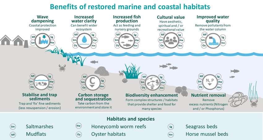
List of Images
 •   Image 1. Conceptual diagram of nature-based solutions                                 16

 •   Image 2. Seven wellbeing goals of the Well Being of Future Generations Act            17

 •   Image 3. WNMP Title page                                                              20

 •   Image 4. Generalised division of intertidal habitats based on elevation in relation to
     tidal height                                                                         23

 •   Image 5. Seagrass                                                                     26

 •   Image 6. Ostrea edulis habitat indicated for the 19th Century                         29

 •   Image 7. Ostrea edulis cemented to intertidal boulder                                 30

 •   Image 8. Sabellaria alveolata colonising artificial material in Welsh intertidal areas 34

 •   Image 9. Managed realignment diagram                                                  36

 •   Image 10. Ynys Hir and Cwm Ivy managed realignments                                   36

 •   Image 11. Picture of Rumney Great Wharf polder fencing under construction             39

 •   Image 12. Native Oyster ecosystem services                                            52

 •   Image 13. Summary image on ecosystem service benefits of restored marine and
     costal habitats                                                              70

 List of Tables
 •   Table 1. Historic datalayers created as part of the project                           13

 •   Table 2. Opportunity datalayers created as part of the project                        13

 •   Table 3. Input layers created for this project                                        13

 •   Table 4. Key processing parameters - native oyster opportunity datalayer              14

 •   Table 5. Key processing parameters - mudflats and saltmarshes opportunity
     datalayer                                                                             14

 •   Table 6. Inundation frequency associated with intertidal habitats                     24

 •   Table 7. Provisioning ecosystem services associated with marine and coastal
     habitats studied for this report                                                      55

 •   Table 8. Regulating ecosystem services                                                56

 •   Table 9. Cultural ecosystem services                                                  57

                                             5
Crynodeb Gweithredol
Ar ran Cyfoeth Naturiol Cymru, ymgymerwyd â phrosiect ar y potensial sy’n bodoli i adfer
cynefinoedd morol o amgylch Cymru, gan ganolbwyntio ar chwe chynefin gwerthfawr:
fflatiau llaid rhynglanwol, morfeydd heli arfordirol, gwelyau morwellt, gwelyau cregyn dilyw,
riffiau’r mwydyn crwybr a chynefin yr wystrysen frodorol. Prif ddiben y prosiect fu dod â
gwybodaeth ynghyd, er mwyn llywio trafodaethau ehangach am gyfleoedd posibl ar gyfer
gwaith adfer morol ac arfordirol yng Nghymru. Mae ffocws penodol wedi bod ar greu, a
chasglu, mapiau neu gynhyrchion gofodol, gan mai ychydig o gynhyrchion gofodol/mapio
yn bodoli sy'n helpu i nodi ardaloedd posibl lle gellir ymgymryd â gweithgareddau adfer a
lle gellir eu canolbwyntio. Fodd bynnag, dylid pwysleisio y byddai angen i unrhyw
brosiectau adfer ymgymryd â gwaith manwl i ddilysu’r safle a phroses o ymgysylltu'n lleol
cyn i'r gwaith adfer gael ei wneud.
Gellir diffinio gwaith adfer fel gwaith sy'n cynnwys ailsefydlu prosesau naturiol,
ymarferoldeb ecosystemau a bioamrywiaeth mewn cynefinoedd diraddiedig, yn ogystal ag
ail-greu cynefin lle mae wedi cael ei golli cyn hyn.
Mae adolygiad llenyddiaeth cynhwysfawr wedi'i gynnal er mwyn darparu'r cyd-destun ar
gyfer adfer morol, ei rôl mewn cynyddu cydnerthedd ecosystemau morol, a'r buddion
lluosog y gall eu darparu. Canolbwyntiodd yr adolygiad hwn ar amrywiaeth o agweddau,
gan gynnwys y ddeddfwriaeth ac ysgogwyr polisi allweddol, mecanweithiau/technegau ar
gyfer cynnal gwaith adfer (gydag astudiaethau achos ledled Cymru, y DU a’r tu hwnt), a'r
buddion a ddarperir gan gynefinoedd morol. Mae'r adolygiad wedi cadarnhau bod ffocws
cynyddol ar adfer rhywogaethau a chynefinoedd morol, fel un dull gweithredu o wrthdroi'r
dirywiad byd-eang mewn bioamrywiaeth. Gall adfer cynefinoedd coll a diraddiedig nid yn
unig helpu i gyflawni dyletswyddau ac amcanion deddfwriaethol, ond gall hefyd arwain at
nifer o fuddion i bobl Cymru a'r tu hwnt. Un ffordd arall o gyfeirio at fuddion gan
gynefinoedd yw fel gwasanaethau ecosystemau. Mae'r chwe chynefin a astudir yma yn
darparu gwasanaethau ecosystemau sylweddol a phwysig, gan gynnwys amddiffynfeydd
arfordirol gwell, ansawdd dŵr gwell, a mwy o ddal a storio carbon, fel y dangosir yn y
ddelwedd crynodeb isod.

                                              6
Delwedd crynodeb o fuddion y gwasanaethau ecosystemau a geir gan gynefinoedd morol
ac arfordirol sydd wedi'u hadfer
Mae'r holl gynefinoedd gwerthfawr hyn yn agored i niwed yn sgil effeithiau'r newid yn yr
hinsawdd, yn bennaf trwy'r cynnydd cymharol yn lefel y môr, a hefyd trwy newidiadau i
ynni gwynt a thonnau, tymheredd, a phatrymau glawiad. Byddai cynyddu neu gynnal eu
maint trwy waith adfer yn mynd rhywfaint o'r ffordd i adeiladu cydnerthedd amgylchedd
morol Cymru, er y cydnabyddir na all pob ymdrech adfer fod yn llwyddiannus yn y pen
draw, neu barhau yn y tymor hwy.

Mae amrywiaeth o fylchau mewn gwybodaeth wedi'u hamlygu trwy gydol y prosiect hwn.
Ar gyfer sawl cynefin, mae ansicrwydd sylweddol yn parhau ynghylch effeithiolrwydd
tebygol mesurau creu/adfer cynefin morol posibl. Mae angen treialon, ymchwil a monitro
cyson pellach i wella'r sylfaen dystiolaeth ac felly’r hyder sy’n bodoli wrth ymgymryd â
gwaith adfer. At hynny, mae llawer o fylchau mewn gwybodaeth sy'n gysylltiedig â
gwasanaethau ecosystemau yn bodoli, o ran cynefinoedd brodorol penodol (gyda
llenyddiaeth yn gymharol brin ar welyau pysgod cregyn er enghraifft) a'r gwasanaethau eu
hunain, yn ogystal â gwerthoedd ariannol cysylltiedig.

Mae sawl cynnyrch gofodol/mapio wedi'u cynhyrchu neu eu cyfuno yn rhan o'r prosiect
hwn, a fydd yn ddefnyddiol iawn wrth amlygu lle mae cyfleoedd i adfer a chreu
cynefinoedd morol yn bodoli yng Nghymru. Mae'n bwysig nodi, fodd bynnag, nad yw'r
mapiau o reidrwydd yn nodi y bydd adfer yn ymarferol neu'n hyfyw yn ariannol mewn
lleoliad penodol. Fodd bynnag, dylai'r mapiau ddarparu ffocws ar gyfer trafodaeth ac
ymchwil pellach i'r potensial ar gyfer gwaith adfer mewn rhai o'r ardaloedd hyn.

Mae'r cynhyrchion mapio hyn yn cynnwys y canlynol:

   •   Haen sy'n nodi ardaloedd yn y gorlifdir a allai fod yn addas ar gyfer creu fflatiau llaid
       a morfa heli trwy adlinio a reolir (er nad yw categoreiddio ardaloedd fel hyn yn
       golygu y byddant o reidrwydd yn ymarferol / yn hyfyw yn ariannol);
                                                7
•   Haenau sy'n amlygu ardaloedd lle gall cyfleoedd / yr amodau cywir fodoli ar gyfer
       morwellt, cynefin yr wystrysen frodorol ac adfer gwelyau cregyn dilyw (mae dwy o'r
       haenau hyn wedi'u creu gan asiantaeth arall ar gyfer y DU gyfan; sylwer nad
       ystyriwyd bod creu haen ar gyfer Sabellaria alveolata yn angenrheidiol ar yr adeg
       hon).
Dylid ystyried pob un o'r haenau data hyn yn gymhorthion cychwynnol i nodi lleoliadau neu
ardaloedd posibl, ac maent yn dod â sawl cyfyngiad a amlygwyd yn yr adroddiad, y mae
angen eu hystyried yn llawn wrth ddefnyddio'r cynhyrchion hyn. Gan yr ystyrir y prosiect
hwn yn un o'r camau cyntaf wrth nodi ardaloedd a allai fod yn addas ar gyfer adfer
cynefinoedd arfordirol a morol yng Nghymru, bydd angen cynnal astudiaethau manwl a
gwaith ymgysylltu lleol bob amser cyn dechrau gwaith ar unrhyw leoliadau penodol i'w
hadfer. Dylid hefyd ymgynghori â chanllawiau perthnasol, lle bônt ar gael, a dylid cyflogi
arbenigwyr lle bo hynny'n briodol.

                                            8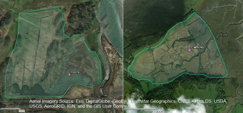
Executive summary
On behalf of Natural Resources Wales, a project on marine habitat restoration potential
around Wales has been undertaken, focussing on six valuable habitats: intertidal mudflats,
coastal saltmarshes, seagrass beds, horse mussel beds, honeycomb worm reefs and
native oyster habitat. The main purpose of the project has been to bring together
information, in order to inform wider discussions about potential opportunities for marine
and coastal restoration in Wales. A particular focus has been to create, and gather, maps
or spatial products, as few spatial / mapping products exist which help identify potential
areas where restoration activities can be undertaken and focussed. However, it should be
emphasised that any restoration projects would need to undergo detailed site validation
and local engagement before restoration is carried out.
Restoration can be defined as including both the re-establishment of natural processes,
ecosystem functionality and biodiversity in degraded habitats, as well as re-creating habitat
where it has previously been lost.
A comprehensive literature review has been undertaken in order to provide the context for
marine restoration and its role in increasing the resilience of marine ecosystems and the
multiple benefits it can provide. This review focussed on a variety of aspects, including the
key legislation and policy drivers, mechanisms / techniques for restoration (with case
studies of projects across Wales, the UK and beyond), and benefits provided by marine
habitats. The review has confirmed that, increasingly, there is a focus on restoration of
marine species and habitats, as one approach to reversing the global decline in
biodiversity. Restoring lost and degraded habitats can not only help meet legislative duties
and objectives, but also harness multiple benefits for the people of Wales and beyond.
Benefits from habitats may also be referred to as ecosystem services. The six habitats
studied here provide substantial and important ecosystem services; including improved
coastal protection, better water quality and more carbon storage and sequestration, as
shown in the summary image below.

Summary image on ecosystem service benefits of restored marine and costal habitats
                                        9
All of these valuable habitats are vulnerable to the impacts of climate change, mostly
through relative sea level rise, and also changes to wind and wave energy, temperature
and rainfall patterns. Increasing or maintaining their extent through restoration would go
some way to building the resilience of the Welsh marine environment; though it is
recognised that not all restoration efforts may ultimately be successful, or persist longer
term.

Various knowledge gaps have been highlighted throughout this project. For several
habitats, considerable uncertainties remain about the likely efficacy of possible marine
habitat creation / restoration measures. Further trials, research and consistent monitoring
are required to improve the evidence base and thus confidence in undertaking restoration.
Furthermore many ecosystem service-related knowledge gaps exist, both with regard to
specific native habitats (with literature relatively scarce on shellfish beds for example), and
services themselves, as well as related monetary values.

Several spatial / mapping products have been produced or brought together as part of this
project, which will be very useful in highlighting where opportunities for marine habitat
restoration and creation exist in Wales. It is important to note, however, that the maps do
not necessarily indicate that restoration will be feasible or financially viable in a given
location . However, the maps should provide a focus for further discussion and
investigation of the potential for restoration in some of these areas.

These mapping products include:

   •   A layer indicating areas in the floodplain that might be suitable for the creation of
       mudflat and saltmarsh through managed realignment (though areas being
       categorised as such does not mean they will necessarily be feasible / financially
       viable) ;
   •   Layers highlighting areas where opportunities / the right conditions may exist for
       seagrass, native oyster habitat and horse mussel bed restoration (two of these
       layers have been created by another agency for the whole of the UK; please note
       that the creation of a layer for Sabellaria alveolata was not considered necessary at
       this point).
All of these datalayers should be considered as initial aides to identifying potential
locations or areas, and come with several limitations which have been highlighted in the
report, and which need to be fully considered when using these products. As this project is
considered to be one of the first steps in identifying areas that could be suitable for coastal
and marine habitat restoration in Wales, detailed studies and local engagement will always
need to be undertaken before pursuing any specific locations for restoration. Relevant
guidebooks, where available, should also be consulted, and specialists employed where
appropriate.

                                              10
1. Introduction
The Well-being of Future Generations Act 2015 and the Environment (Wales) Act 2016
formalised Welsh Government’s commitment to the sustainable management of natural
resources (SMNR) and their objective to halt and reverse the decline in biodiversity, as
well as maintaining and enhancing the resilience of ecosystems. Increasingly, there is a
focus on the restoration of species and habitats, as one approach to reversing the global
decline in biodiversity. For example, the United Nations (UN) Decade on Ecosystem
Restoration, which started in 2021, is a rallying call for the protection and revival of
ecosystems all around the world, for the benefit of people and nature. Restoring lost and
degraded habitats can not only help meet legislative duties and objectives but also
harness multiple benefits for the people of Wales and beyond.
Few spatial products exist which help identify areas where restoration activities can be
undertaken and focussed. Thus, this project was commissioned to identify spatial
opportunities for restoration of marine and coastal habitats and species, and also provide
an assessment of the wider benefits of such restoration, in Welsh waters. This work also
aimed to bring together existing evidence and inform a wider discussion in Wales about
the potential opportunities and benefits of restoration at sea.
Restoration in the context of this project includes both the re-establishment of natural
processes, ecosystem functionality and biodiversity in degraded habitats, as well as re-
creating networks of habitat where these have been lost (International Union for
Conservation of Nature (IUCN), 2019).
The key objective of this project was to, where appropriate, develop and/or signpost a
series of datalayers to demonstrate the spatial opportunities for the restoration of marine
and coastal habitats and species in Welsh waters. The focus has been on the following six
habitats / species: intertidal mudflats, coastal saltmarshes, seagrass beds, horse mussel
beds, Sabellaria alveolata reefs and native oyster habitats. These habitats are all of
principal biodiversity importance in Wales. To provide the context for marine restoration
and its role in increasing the resilience of marine ecosystems, a literature review has also
been undertaken to document a variety of aspects, including the key legislation and
drivers, mechanisms / techniques and ecosystem services.
This report is structured as follows.
• Section 1: Introduction;
• Section 2: Methodology;
• Section 3: Literature review (focussed on ecology and ecosystem services related
to the habitats / species, as well as drivers and techniques for restoration);
• Section 4: The opportunity datalayers (and how they may be used); and
• Section 5: Conclusions and recommendations.
Maps depicting the opportunity datalayers can be found in Section 4, and maps for all the
other created datalayers have been provided in Appendix A.
112. Methodology
2.1 Introduction
As noted above, this project involved the following key tasks:
(1) The mapping of opportunities in relation to six marine habitats/species; and
(2) A literature review.
The methods employed to undertake these tasks are now briefly outlined in turn in
Sections 2.2 and 2.3.
2.2 Opportunity mapping
The key objective of this project has been to identify and, where appropriate / not already
available, develop a series of datalayers which demonstrate the spatial opportunities for
the restoration of six marine and coastal habitats and species in Welsh waters. These six
habitats are: intertidal mudflats, coastal saltmarsh, seagrass beds, horse mussel beds,
Sabellaria alveolata reefs and native oyster habitats.
The following iterative steps have been undertaken:
1. Compile / signpost data on existing and historic extent / mapping of the habitats /
species in Wales. Create / compile historic datalayers where possible. This was
informed by a workshop and discussions with experts from Natural Resources Wales
(NRW) and academia.
2. Compile information / evidence on habitat requirements (drawing on the literature
review, see next Section).
3. Compile information on similar / existing opportunity datalayers. This has served as a
gap analysis.
4. Develop methodologies for datalayer creation. This was informed by a workshop and
detailed discussions with NRW experts.
5. Datalayer creation. Following the gap analysis, this focussed on the creation of two
datalayers, native oyster, and a combined mudflat / saltmarsh datalayer. Furthermore,
two dedicated average tidal flow and wave datalayers have been created as input
datalayers, by extracting relevant data from ABPmer’s tide and wave hindcast models.
Please note that a beneficial use-related datalayer has also been created; this shows
sources of fine sediment for saltmarsh and mudflat recharge in Wales.
Tables 1 to 3 below summarise what historic, input and opportunity mapping / datalayers
have been compiled and created for the purpose of this project. Tables 4 and 5 then
provide high level information on the processing steps for the two dedicated datalayers
which have been produced. Maps depicting the opportunity datalayers can be found in
Section 4 (including two related layers created by the Joint Nature Conservation
Committee (JNCC)). Maps for all of the other created layers are provided in Appendix A.
12Table 1. Historic datalayers created as part of the project
Subject / Species Layer Detail
created?
Native oyster habitat Yes One point layer each, derived from OBIS and NBN.
Shows records of individuals, not nec. reefs. Age of
record categorised.
Horse mussel habitat Yes Same as above
Sabellaria alveolata reefs Yes Same as above
Seagrass meadows No -
Mudflats No -
Saltmarshes Yes Combined polygon layer for selected estuaries
(collating previous efforts only)
Table 2. Opportunity datalayers created as part of the project
Subject / Species Layer Detail
created?
Native oyster habitat Yes One point layer each, derived from OBIS and NBN.
Shows records of individuals, not nec. reefs. Age of
record categorised.
Horse mussel habitat No UK wide layer being developed by JNCC
Sabellaria alveolata reefs No Not considered to be required
Seagrass meadows No UK wide layer being developed by JNCC
Mudflats & Saltmarshes Yes One combined polygon layer for both habitats,
showing opportunities on current floodplain (for
method overview, see next table)
Table 3. Input layers created for this project
Subject Detail
Tidal Energy One raster datalayer, showing (depth averaged) mean spring tidal flow
speeds
Wave Energy One raster datalayer, showing average annual significant wave height
Beneficial use One point datalayer, showing potential soft material sources for beneficial
use, including types of material (maintenance dredge disposal sites)
13Table 4. Key processing parameters applied to creating native oyster opportunity
datalayer
Factors / Criteria Input layer(s)
Predictors
Bathymetry / depth 0 to 80 m EMODnet bathymetry
to seabed
Tidal energy / Less than 1 m s-1 Dedicated layer produced for this
current speed project (see above)
Substrate Mixed and coarse sediments, JNCC marine habitat data product:
mud, hard silt, rocks, muddy EUNIS level 3 combined map
sand.
Table 5. Key processing parameters applied to creating mudflats and saltmarshes
opportunity datalayer
Factors / Criteria Input layer(s)
Predictors
Floodplain `All tidal & tidal / fluvial areas Welsh / NRW Zone 3 Floodmap
selected. Foreshore, beaches
and areas already subject to
tidal influence removed.
SMP Policy For all 3 epochs, (above) Welsh / NRW Shoreline
floodplain areas were Management Plan layer (available
overlapped with the different from Lle Geoportal)
policies.
2.3 Literature review
A comprehensive literature review has been undertaken, and is presented in Section 3;
this documents the following:
• the key legislation and drivers with respect to habitat restoration;
• the ecology of the six habitats, and their underlying physical / chemical
requirements;
• the main mechanisms for delivering restoration / creation of the habitats in practice;
and
• the wider benefits that could potentially be obtained by delivering restoration of
these habitats and species.
143. Literature review
3.1 Introduction
This literature review firstly presents background key legislation and drivers for marine
habitat restoration in Section 3.2, before Section 3.3. discusses the ecology and habitat
requirements of the six habitats / species which are the focus of this report. Section 3.4
then reviews key mechanisms and techniques for their restoration, and related natural
accounting and ecosystem services are outlined in Section 3.5 (with a summary table
provided in Section 3.5.3).
3.2 Key Legislation and Drivers for Marine Habitat
Restoration
3.2.1. International Drivers
There are a myriad of drivers for marine habitat restoration. Many international drivers
exist, and have often informed / fed into Welsh legislation and policy, which is outlined
further below. Notable recent international initiatives, which the UK and Wales are part of,
include the following:
• The Leaders’ Pledge for Nature: Political leaders participating in the United Nations
Summit on Biodiversity in September 2020, representing 84 countries from all
regions and the European Union, committed to reversing biodiversity loss by 2030.
• The Global Ocean Alliance and the ‘30 by 30’ initiative: An initiative / alliance joined
by over 30 countries (as of November 2020), which is pushing for at least 30% of
the global ocean to be protected in Marine Protected Areas (MPAs) by 2030.
• The Post-2020 Global Biodiversity Framework: This builds on the Strategic Plan for
Biodiversity 2011-2020 and sets out an ambitious plan to implement broad-based
action to bring about a transformation in society’s relationship with biodiversity and
to ensure that, by 2050, the shared vision of living in harmony with nature is fulfilled.
• The 2021 United Nations Climate Change Conference, also known as COP26: The
26th United Nations Climate Change conference is scheduled to be held in Glasgow,
Scotland, in November 2021 under the presidency of the UK.
• The United Nations (UN) Decade on Ecosystem Restoration (2021-2030): This was
proclaimed by the UN General Assembly following a proposal for action by over 70
countries. Its aim is the building of a strong, broad-based global movement to ramp
up restoration and put the world on track for a sustainable future. This includes
political momentum for restoration, as well as thousands of initiatives on the ground.
It is also worth noting that the restoration of the six habitats which have been the focus of
this project can be interpreted as constituting nature-based solutions (Image 1). The IUCN
defines such solutions as ‘actions to protect, sustainably manage, and restore natural and
modified ecosystems that address societal challenges effectively and adaptively,
simultaneously providing human well-being and biodiversity benefits’.
15University of Oxford, 2021
Image 1. Conceptual diagram of nature-based solutions
3.2.2. Welsh legislation, policy and plans
Key Welsh policies, legislation and plans with regard to marine habitat restoration are now
outlined below, to provide the context for marine restoration and its role in increasing the
resilience of marine ecosystems.
Well-being of Future Generations (Wales) Act 2015
The Well-being of Future Generations (Wales) Act 2015 seeks to improve the social,
economic, environmental and cultural well-being of Wales. This Act put in place seven well-
being goals which are outlined in Image 2. Under the ‘Resilient Wales’ goal, it aims to create
‘a nation which maintains and enhances a biodiverse natural environment with healthy
functioning ecosystems that support social, economic and ecological resilience and the
capacity to adapt to change (for example climate change).'
16Welsh Government, 2015
Image 2. Seven wellbeing goals of the Well Being of Future Generations (Wales) Act
Environment (Wales) Act 2016
The Environment (Wales) Act 2016 sets out the requirement for the ‘sustainable
management of natural resources’. While ‘restoration’ is not explicitly outlined, Sections 3,
4, 6 and 7 of the Act are the key sections which are of relevance to ‘restoration’. Section 3
on the ‘sustainable management of natural resources’ notes that objective is to;
‘maintain and enhance the resilience of ecosystems and the benefits they provide and, in so
doing -
(a) meet the needs of present generations of people without compromising the ability of
future generations to meet their needs, and
(b) contribute to the achievement of the well-being goals in section 4 of the Well-being of
Future Generations (Wales) Act 2015 (anaw 2).’
Section 4 sets out principles for the sustainable management of natural resources, and notes
the “principles of sustainable management of natural resources” are to;
‘(a) manage adaptively, by planning, monitoring, reviewing and, where appropriate,
changing action;
(f) take account of the benefits and intrinsic value of natural resources and ecosystems;
(i) take account of the resilience of ecosystems, in particular the following aspects—
(iv) the condition of ecosystems (including their structure and functioning).’
Section 6 of the Act requires public authorities to seek to ‘maintain and enhance biodiversity
[…] in the exercise of their functions’. Section 7 additionally requires Welsh Ministers to
publish a list of living organisms and habitats in Wales, which are considered of key
significance to sustain and improve biodiversity in relation to Wales Section 7 of the Act.
The Act also notes that the Welsh Ministers must ‘take all reasonable steps to maintain and
enhance the living organisms and types of habitat included in any list published under this
section and encourage others to take such steps’.
17All of the six habitats / species which are the focus of this report are listed as being ‘of
principal importance’ under Section 7 of the Environment (Wales) Act 2016.
The 2017 Natural Resources Policy
The Natural Resources Policy focusses on improving the way Wales’ natural resources are
managed. This is a key part of the delivery framework for the sustainable management of
natural resources, as established by the Environment (Wales) Act.
The policy highlights three main challenges faced with regard to natural resources as follows:
• Improving ecosystem resilience;
• Climate change and the decline in biological diversity; and
• The UK’s withdrawal from the EU.
In addition, three national priorities for the management of Wales’ natural resources are
listed, namely:
• Delivering nature-based solutions;
• Increasing renewable energy and resource efficiency; and,
• Taking a place-based approach.
The 2020/21 Nature Recovery Action Plan for Wales
Welsh Government published the national biodiversity strategy ‘The Nature Recovery Action
Plan for Wales’ in 2015, and refreshed it in 2020/21. Its ambition is to ‘halt the decline in
biodiversity by 2020 and then reverse the decline, for its intrinsic value, and to ensure lasting
benefits to society. The Plan sets out how Wales will deliver the commitments of the UN
convention on biological diversity, the strategic plan for biodiversity 2011-2020 and the 20
associated Aichi targets (a short term framework for action), as well as the EU biodiversity
strategy. It confirms that resilient ecological networks are vital for nature recovery.
The Plan focusses on six objectives for nature recovery in Wales, and actions to reverse the
decline of biodiversity are set out under each objective. The objectives are as follows:
• Objective 1: Engage and support participation and understanding to embed
biodiversity throughout decision making at all levels.
• Objective 2: Safeguard species and habitats of principal importance and improve
their management.
• Objective 3: Increase the resilience of our natural environment by restoring
degraded habitats and habitat creation.
• Objective 4: Tackle key pressures on species and habitats.
• Objective 5: Improve our evidence, understanding and monitoring.
• Objective 6: Put in place a framework of governance and support for delivery.
The actions are allocated to specific partners, including public bodies and local nature
partnerships. Public bodies are required to consider using the Plan as a basis on which to
base a ‘biodiversity and ecosystem resilience duty forward plan’.
18Planning Policy Wales (2016 / 2018)
Welsh terrestrial planning policy is outlined in the Planning Policy Wales (PPW), which was
first published in 2016 (and last updated in 2021). The primary objective of PPW is ‘to
ensure that the planning system contributes towards the delivery of sustainable
development and improves the social, economic, environmental and cultural wellbeing of
Wales, as required by the Planning (Wales) Act 2015, the Well-being of Future
Generations (Wales) Act 2015 and other key legislation’ (Welsh Government, 2018). PPW
includes specific policies on conserving and enhancing the natural environment through
planning. It states that the planning system should contribute to the delivery of sustainable
development and improve the social, economic, environmental and cultural well-being of
Wales. The PPW and the associated 2021 National Plan ‘Future Wales’ concentrate on
development and land use issues of national significance, indicating areas of major
opportunities and change, highlighting areas that need protecting and enhancing and
helping to co-ordinate the delivery of Welsh Government.
Under Section 2 (Achieving Well-being Through Placemaking), key considerations,
including those in relation to the environment, are set out. This notes that, as part of their
decision-making processes planning authorities should consider whether the resilience of
ecosystem will be improved. As part of Section 6 (Recognising the Special Characteristics
of Places) of the planning policy, it is ruled that; ‘to ensure mechanisms allow for the
identification of potential habitat, the maintenance of existing assets and networks and
promote the restoration of damaged, modified or potential habitat and the creation of new
habitat’ must be implemented. Furthermore, the same paragraph of the PPW states that
‘planning decisions should incorporate measures which seek the creation, restoration and
appropriate management….’. For connectivity to be implemented, one should seek to
‘develop functional habitat and ecological networks within and between ecosystems and
across landscapes, building on existing connectivity and quality and encouraging habitat
creation, restoration and appropriate management. The opportunities could include
enlarging habitat areas, developing buffers around designated sites…’.
Technical advice notes (TANs) have been produced in connection with the PPW, for
example, TAN 5 is on ‘nature conservation and planning’.
Future Wales – the 2021 National Plan
Future Wales – the National Plan 2040 is the Welsh national development framework,
setting the direction for development in Wales to 2040. Future Wales is a spatial plan, which
means it sets a direction for where there should be investment in infrastructure and
development for the greater good of Wales and its people. Future Wales’ defines 11
‘Outcomes’, which are overarching ambitions to be achieved by 2040, based on the national
planning principles and national sustainable placemaking outcomes set out in PPW.
Outcomes 9 to 11 are particularly pertinent for this report; these aim to achieve ‘A Wales
where people live’:
• (9) ‘... in places that sustainably manage their natural resources and reduce
pollution’;
• (10) ‘... in places with biodiverse, resilient and connected ecosystems’; and
• (11) ’... in places which are decarbonised and climate‑resilient’.
19The 2019 Welsh National Marine Plan (WNMP)
The Welsh National Marine Plan (WNMP) was prepared
and adopted under the Marine and Coastal Access Act
2009 and in conformity with the UK Marine Policy
Statement. It represents the start of a process of
shaping Welsh seas to support economic, social, cultural
and environmental objectives. Its overarching objective
is to
‘Support the sustainable development of the Welsh
marine area by contributing across Wales’ well-being
goals, supporting the Sustainable Management of
Natural Resources (SMNR) through decision making
and by taking account of the cumulative effects of all
uses of the marine environment’.
Under the topic ‘living within environmental limits’, the
following key objectives of note to this report are as
follows:
Image 3. WNMP Title page
• ‘Support the achievement and maintenance of Good Environmental Status (GES)
and Good Ecological Status (GeS).
• Protect, conserve, restore and enhance marine biodiversity to halt and reverse its
decline including supporting the development and functioning of a well-managed
and ecologically coherent network of Marine Protected Areas (MPAs) and resilient
populations of representative, rare and vulnerable species.
• Maintain and enhance the resilience of marine ecosystems and the benefits they
provide in order to meet the needs of present and future generations.’
Many of the policies require the observation of the Environmental Impact Assessment
(EIA) mitigation hierarchy. Notably, Policy ENV_01 on ‘Resilient marine ecosystems’
states:
‘Proposals should demonstrate how potential impacts on marine ecosystems have been
taken into consideration and should, in order of preference:
a. avoid adverse impacts; and / or
b. minimise impacts where they cannot be avoided; and / or
c. mitigate impacts where they cannot be minimised.
If significant adverse impacts cannot be avoided, minimised or mitigated, proposals must
present a clear and convincing case for proceeding.
‘Proposals that contribute to the protection, restoration and / or enhancement of marine
ecosystems are encouraged.’
20Policy ENV_01 aims to ensure that biological and geological components of ecosystems
are maintained, restored where needed and enhanced where possible, to increase the
resilience of marine ecosystems and the benefits they provide.
Also particularly noteworthy is policy ENV_02 on MPAs, which states:
‘Proposals should demonstrate how they:
a. avoid adverse impacts on individual Marine Protected Areas (MPAs) and the
coherence of the network as a whole;
b. have regard to the measures to manage MPAs; and
c. avoid adverse impacts on designated sites that are not part of the MPA network.’
There is also a table in the WNMP detailing the Plan policies that support the achievement
of Good Environmental Status under the Marine Strategy Framework Directive, and the
achievement of Water Framework Directive goals are referenced in connection with Policy
ENV_06 on ‘Air and water quality’.
In 2020, Welsh Government published an implementation guidance document to support
the effective and consistent implementation of WNMP policies..
3.2.3. European Transposing Regulations and the Welsh MPA
network
The regulations on EIA, WFD and MSFD referenced in the WNMP have been transposed
into various pieces of UK and Welsh regulations / legislation, which are not listed
separately here. However, these can all drive marine habitat creation to varying degrees,
as can other legislation related to European transposing regulations, notably the Birds and
Habitats Directives. The latter seek to establish a network of protected sites, which are
known as Special Protection Areas (SPAs) and Special Areas of Conservation (SACs).
Marine SACs and SPAs, as well as other internationally and nationally protected sites
make up Wales’ MPA network, which is what WNMP policy ENV_02 refers to. There are
139 MPAs 1 in Welsh waters, that are made up of:
• 13 Special Protection Areas (SPAs);
• 15 Special Areas of Conservation (SACs);
• 1 Marine Conservation Zone (MCZ);
• 107 Sites of Special Scientific Interest (SSSIs); and
• 3 Ramsar sites.
Many of these MPAs contain one or more of the six habitats which form the focus of this
report as designated features. Where these are purposely damaged as part of a
development, compensation may need to be provided (ABPmer, 2020). Where the MPA
1
It should be noted that the number of sites within the MPA network is reported differently (140) by
Welsh Government, 2018. This is assumed to be a function of the SSSI features that are considered
to be coastal / marine within the respective counts. The latest details with respect to designations
should be obtained from Lle – A Geo-Portal for Wales (inshore and coastal), or JNCC’s Protected
Area Datasets (offshore).
21features are in unfavourable condition, then management action may be undertaken to
restore or enhance a given habitat.
It is worth noting that, post-Brexit, the provisions of the above mentioned directives
generally remain, as they are implemented in national law, with adjustments to account for
Brexit. For example, the Habitats Regulations have been amended by The Conservation of
Habitats and Species (Amendment) (EU Exit) Regulations 2019, which mirror existing
provisions.
3.3 Habitat Background for The Six Habitats
For each of the six habitats which are the focus of this report, some background
information is now provided, including Welsh context, status, ecology, and sensitivities and
tolerances (including in relation to potential impacts arising from climate change).
3.3.1. Saltmarsh and mudflat
Welsh context
There are 76 km² of saltmarshes and 434 km² of intertidal sand and mudflats in Wales
(NRW, 2020). Both habitats are widespread across the Welsh coast, where they are
present in all major estuaries and inlets as well as in other more sheltered locations,
including the lee of spits and in the shelter of islands (Welsh Government, 2018). The
largest extents are found in the estuaries of Carmarthen Bay, whilst the Dee and Severn
Estuaries also contains extensive stretches of saltmarsh.
Saltmarshes and mudflats are listed in Annex I of the Habitats Directive and are also both
‘habitats of principal importance’ under Section 7 of the Environment (Wales) Act 2016.
These habitats also frequently form a major component of two encompassing ‘habitat’
features, namely ‘estuaries’ and ‘large shallow inlets and bays’. Many Welsh mudflats and
saltmarshes are furthermore protected as features of Ramsar sites, SACs or SSSIs, and /
or constitute supporting habitats for the bird interest features of many SPAs. Intertidal
mudflats are also listed on the OSPAR Convention list of ‘threatened and/or declining
species and habitats’ in the North-East Atlantic.
Historical trends
Nationally and globally, there have been extensive historic losses of these intertidal
habitats, chiefly due to human activities, mostly related to land claim, and the construction
of sea defences, ports and harbours. It has been estimated that approximately 100,000 ha
of British saltmarshes were lost between 1600 and 1900, mainly to gain more land for
agricultural production (Toft et al., 1995). More recently, comparatively small-scale
industrial and residential developments have been the main driver for land claim (Adam,
2002). Available historic mapping for saltmarshes shows that UK wide trends are
replicated in Wales. For example, a comparison of saltmarsh extent at Rumney to
Peterstone, east of Cardiff shows that, between the early 1950s and 2017, 22% of the
saltmarsh had been lost along this Severn Estuary frontage (NRW, 2021a). This erosion
22will at least in part have been due to a process known as ‘coastal squeeze’, which is
mostly related to sea level rise 2.
Ecology
Intertidal mudflats and saltmarshes are generally understood to develop between the
levels of the highest astronomical tides (HAT) and mean low water springs (MLWS) on
tidal, sheltered, coasts, where the predominant sediments are silts and muds. These fine
sediments are kept in suspension where currents are fast, and settle when the currents are
slowest (French, 1997).
Tidal flats are un-vegetated ‘banks of mud or sand that are exposed at low tide’, which
generally slope gently seawards. Image 4 illustrates how, as elevation increases, and thus
tidal inundation frequency decreases, vegetation can become established and saltmarshes
develop throughout temperate regions (Trenhaile, 1997). Sediments needed for this
elevation increase (‘accretion’) can be derived from marine, coastal, and fluvial sources, as
well as in situ reworking (Pethick, 1984).
Source: Davis et al., 2018
Image 4. Generalised division of intertidal habitats based on elevation in relation to
tidal height
The more shelter is afforded to mudflats and saltmarshes, from both wave and tidal
energy, the more accretion / sedimentation is likely to take place. Saltmarsh plants can
play a crucial role in such shelter (e.g. Adam, 2002), as can higher topographical features,
such as islands and bunds, which can provide protection from waves and wind, and/or
slow tidal currents. Elevation and inundation frequency is also important, as it is only whilst
the habitat is covered in water (the so-called ‘hydroperiod’) that sediment laden water can
reach it.
2 Coastal squeeze is ‘the loss of natural habitats or deterioration of their quality arising from anthropogenic
structures, or actions, preventing the landward transgression of those habitats that would otherwise naturally
occur in response to sea level rise in conjunction with other coastal processes. Coastal squeeze affects habitat
on the seaward side of existing structures’ (Defra et al., 2021).
23The lower lying a site, the more frequently inundated it is, and the higher accretion rates
tend to be. For example, French (2006) quotes the example of a Severn Estuary low
saltmarsh which accreted at a rate of 12.1 mm yr-1, whereas on the highest level marsh
(which would only be covered by high spring tides and surges), the rate was much reduced
at 2.3 mm yr-1. Conversely, the higher a site is, the more likely plant roots will have
established to hold sediments together and prevent re-suspension / erosion during high
wind / wave conditions, or on occasions where heavy rainfall coincides with low tide.
Furthermore, there needs to be sediment available for accretion. In some Welsh estuaries,
water column suspended sediment concentrations (SSC) can be very low, and accretion
across intertidal habitats thus minimal. Conversely, in some estuaries, notably the Severn
and Dee Estuaries, SSC tend to be very high, such that accretion can be rapid in sheltered
locations. Suspended sediment loads are not constant in any given estuary, they are
known to vary depending on tidal state, tidal height, freshwater flows, season and weather
(e.g. Uncles et al., 2004). SSC are furthermore invariably higher at the bed than at the
water surface (e.g. Kirby, 1986).
Saltmarshes are generally divided into several zones; these zones broadly correspond to
the frequency of tidal inundation and the associated effects of salinity and tidal scouring.
Four main saltmarsh zones can be distinguished, and are commonly referred to as
‘pioneer’, ‘low’, ‘middle’ and ‘upper’ or ‘higher’ marsh. These saltmarsh types are typically
associated with a characteristic number of tidal inundations per year (Table 6), which can
broadly be related to tidal levels as shown in Image 4.
Table 6. Inundation frequency associated with intertidal habitats
Inundations Per Year Habitat
More than 450 Mudflat
450 to 360 (maximum continuous exposure: 9 days; minimum daily Pioneer marsh
daylight submergence of 1-2 hours)
Less than 360 (typical 300) (minimum continuous exposure: 10 days; Low, mid and
maximum daily daylight submergence of 1 hour) upper/higher
saltmarsh
Source: Nottage and Robertson, 2005; Toft et al., 1995
There are approximately 40 species of higher plants found in saltmarsh habitats, with any
individual saltmarsh containing between 10 and 20 species, although in a broader sense
there are a larger number of plant species found at the upper and transitional zones
(Boorman, 2003). The National Vegetation Classification (NVC) system recognises 28
communities of saltmarsh vegetation, which include the following (NRW, 2019a):
• Pioneer communities (i.e. early colonisers, beginning a chain of ecological
succession), which are dominated by species such as such as Spartina anglica
(often present as a result of deliberate introduction historically) and Salicornia spp.;
• Lower and middle marsh communities, comprised of species such as Puccinellia
maritima, Atriplex portulacoides and Limonium vulgare;
• Mid to upper marsh communities, dominated by species such as Festuca rubra and
Juncus maritimus; and
• Upper marsh communities, including species such as Agrostis stolonifera, J.
maritimus or Elytrigia altherica.
24Additional plant communities which can also be present on saltmarsh are covered by the
NVC system as well; these include certain inundation grassland types, brackish reedbeds
and swamp communities and mires (Rodwell 1991, 1992 and 1995).
Each saltmarsh species has a different tolerance to tidal flooding, and therefore a different,
although often overlapping, vertical range. Spartina is the saltmarsh species most tolerant
of tidal inundation, and its distribution was hence found to be slightly less closely related to
tidal levels than other plants (Clarke et al., 1993).
Saltmarsh zonation can also be impacted by other variables; these, however, tend to be
less important than the inundation frequency / hydroperiod discussed above. For example,
the nature of the sediment may influence the elevation that saltmarsh species occur. On
sandier substrates, lower marsh zones tend to be at higher elevations due to the lower
nutrient contents of sand (Adam, 2002). In larger estuaries, and estuaries with a larger
tidal range, the limits of species also tend to be farther up the shore than predicted by the
level of MHWN alone. This is due to the generally greater degree of exposure to wind and
wave action, increased velocity of flows and higher turbidity variation (Clarke et al., 1993;
Leggett et al., 2004). Chemical factors can also have an influence; for example,
excessively waterlogged sediments due to over-consolidation can lead to low oxygen
diffusion rates, and consequently low sediment redox potential and retarded plant
establishment (e.g. Garbutt et al., 2006).
Sensitivity and tolerance
With regard to salinity tolerance, saltmarsh plants exhibit a variety of tolerances, with more
sensitive species typically found in upper to high marsh zones. Where salinities are lower,
further up estuaries or where there are transitions to freshwater communities, brackish
reedbeds would typically develop. Mudflats can establish in very low and high salinity areas,
with the invertebrate communities inhabiting them changing according to salinity regime.
Saltmarshes are not sensitive to changes in oxygenation, but are slightly sensitive to
changes in nutrient levels / enrichment and heavy metal contamination. These habitats are
furthermore moderately sensitive to contamination by synthetic compounds and are highly
sensitive to hydrocarbon contamination (i.e. from oil spills) (MarLIN, 2001; 2004).
Mudflats and saltmarshes face various threats from climate change; the primary threats are
relative sea level rise, changes to wind and wave energy, temperature and precipitation.
Where sufficient sediment is present in a given system’s water column, then these habitats
are relatively resilient and can keep pace with sea level rise to various extents by accreting
/ increasing in height. However, their landward movement is often impeded, and over time,
they would be expected to be ‘squeezed’ as more and more of their seaward margins
become subtidal. This retreat could be further exacerbated by storm damage, particularly if
such events become more frequent, as storms often cause substantial intertidal habitat
erosion, particularly along their seaward edges. Upper saltmarsh areas conversely
frequently benefit from storm events as large volumes of sediment may be delivered.
Changes in temperature could lead to the decline in cover for several invertebrate and marsh
plant species, as suitable conditions shrink with rising temperatures (Marine Climate Change
Impacts Partnership (MCCIP), 2018a).
253.3.2. Seagrass beds
Welsh context
There are around 7.3 km² of mapped seagrass beds in Wales, with the largest extents
found in the Severn Estuary, as well as around Anglesey and in Milford Haven.
Seagrasses are deemed as scarce in Wales (present only in 16–100 ten km squares)
(Stewart and Williams, 2019), although not necessarily declining. NRW (2016) note that
‘intertidal seagrass beds have increased in extent’ although the timescales over which this
change has occurred are unclear.
Seagrass beds are a habitat of principal importance under Section 7 of the Environment
(Wales) Act 2016. Zostera beds are also listed as threatened and declining under OSPAR.
Many Welsh seagrass beds are located within designated sites, where they constitute a
component part of larger features such as ‘estuaries’ or ‘large shallow inlets and bays’,
although they are not an ‘Annex I’ habitat in their own right. Notable seagrass habitats are
for example included in the Pembrokeshire Marine / Sir Benfro Forol and Severn Estuary
SACs. In addition, seagrass is listed as a feature in nine SSSIs, including Milford Haven
Waterway and the Traeth Lafan SSSI (Welsh Government, 2018).
Source: Andy Pearson
Image 5. Seagrass
Historical trends
Globally, seagrass meadows are declining at an unprecedented rate (Waycott et al., 2009;
Orth et al., 2006). In the UK, a series of research papers have clearly defined seagrasses to
be under threat and in a perilous state (Jones and Unsworth, 2016; Jones et al., 2018;
Unsworth et al., 2017). Seagrass was thought to be once very abundant and widespread
around the British coasts, but serious declines have occurred, in particular due to poor water
quality (eutrophication and other pollutants), land claim and a severe outbreak of a
suspected ‘wasting disease’ in the early 1930s (Davison and Hughes, 1998; Butcher, 1933;
Green et al., 2021). Such an outbreak of disease was probably exacerbated by poor
estuarine and coastal water quality (Short and Wyllie-Echeverria, 1996). The extent of the
damage in Wales is not well known, as seagrass was poorly mapped before the disease
struck (Brown, 2015).
26Recovery of eelgrass beds in the UK has been slow and patchy, with loss still continuing in
many places. However, cases of recovery have occurred, such as substantial expansion
within intertidal Z. noltii beds in Milford Haven in West Wales (Bertelli et al., 2017), and
slight expansion with substantial density increases in the Skomer MCZ (Burton et al.,
2019).
Ecology
Seagrass beds develop in intertidal and shallow subtidal areas, in areas sheltered from
significant wave action. Two species of Zostera occur in the UK; eelgrass (Z. marina; often
used interchangeably with Z. angustifolia 3) and Dwarf eelgrass (Z. noltii). Z. marina is the
largest of the British seagrasses (with trailing leaves up to 1 m long) and typically occurs in
the shallow sublittoral down to 4 m depth, in fully marine conditions and on muddy to
relatively coarse sediments (occasionally with a mixture of gravel) (Davison and Hughes,
1998; Dale et al., 2007). Dwarf eelgrass, Z. noltii occurs higher on the shore, on the intertidal
and upper extent of the subtidal, on substrates of fine, detritus-rich sand and mud.
Please note that widgeon grass (Ruppia spp.) is a genus of aquatic freshwater plants
found in the UK including Wales, that have similar environmental preferences to Zostera
spp., and are sometimes treated as seagrasses. The two species of widgeon grass found
in the UK (beaked tasselweed, R. maritima and spiral tasselweed, R. cirrhosa) are not
strictly considered as part of the traditional seagrass arrangement (Kuo and Den Hartog,
2001), but they are commonly grouped with Zostera spp. 4 as they can occupy a similar
niche due to their pronounced salinity tolerance (Zieman, 1982)..
Zostera spp. are flowering plants (angiosperms) adapted to saline conditions. These plants
have stems (rhizomes) that spread horizontally below the sediment surface, and shoots
that grow above the surface forming expansive ‘meadows’ in both the intertidal and
shallow subtidal zones. In contrast to other marine vegetation (such as macroalgae),
seagrasses flower, develop fruit and produce seeds like terrestrial plants. They also have
roots and a vascular system that transports gases and nutrients around the plant (NRW,
2019b).
Seagrass leaves of both Zostera species slow down water currents / flow rates under the
canopy and encourage the settlement of fine sediments, detritus and larvae, which in turn
stabilises the sediments and protects against wave disturbance. This increases the
species diversity within the seagrass bed, with Z. marina beds in particular attracting
wrasse and goby species (also associated with kelp beds), pipe fish, sea anemones,
neogastropods, prosobranch molluscs and brooding cuttlefish.
Sensitivity and tolerance
In the UK, Z. marina is most commonly restricted to a maximum of 7 m water depth,
however the maximum known depth of Z. marina in the British Isles is 10 m (Dale et al.,
2007). Z. noltii is an intertidal species. Z. marina prefers enclosed areas including
embayments, lagoons and estuaries, whilst Z. noltii is commonly found in straits, sea
3
There is some discussion around the taxonomy of this species.
4
Please note that R. maritima is included in the definition of Biodiversity Action Plan (and by extension
Section 7) seagrass habitat (JNCC, 2008a).
27You can also read