Review of Application by TowerNorth Development for a Cell Tower at 75 Eastern Avenue, Essex Massachusetts
←
→
Page content transcription
If your browser does not render page correctly, please read the page content below
Thinking outside the sphere

         Review of Application
     by TowerNorth Development
for a Cell Tower at 75 Eastern Avenue,
          Essex Massachusetts

June 8, 2021

www.isotrope.im     Isotrope, LLC ◦ 503 Main Street ◦ Medfield, MA ◦ 02052   508 359 8833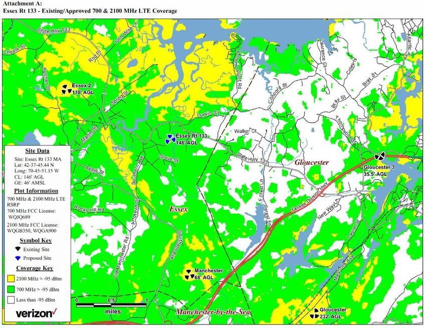
Isotrope, LLC

Introduction
TowerNorth Development, LLC (TowerNorth) applied to the Town of Essex Zoning Board of
Appeals (Board) for variances to construct a cell tower at 73 Eastern Avenue. The Board engaged
the services of Isotrope to review the application for technical veracity. Included in the requested
scope of services are:
    • Review application’s
             o RF report and coverage analysis
             o alternate site analysis
             o status of necessary licenses to operate
             o RF exposure
             o FAA compliance
             o real estate valuation [report]
             o adequacy of the balloon test conducted last August.
    • Consider the feasibility of using small cells such as C-RANS or repeaters or a smaller tower
        to fill any gap in coverage
    • Provide opinion on
             o whether there is a significant gap in coverage
             o whether the proposed tower, on the proposed site is the only feasible alternative.

Statement of impartiality: We take no position on whether the proposed facility should be
approved or not. Our goal is to provide facts and opinion on matters of fact to help the Board
accumulate a record and follow a process that leads to a well-reasoned decision.

Executive Summary
The nature of any deficits in Verizon’s provision of personal wireless service around the proposed
facility is not related to lack of working signal strength (“coverage”) from existing facilities. The
issue the proposed facility is intended to address is capacity. The evidence of a capacity shortfall
is limited to making inferences from C-Squared Systems’ sector coverage maps. There is no direct
evidence, and the Board must infer there is a capacity problem from the size of the red coverage
area on C-Squared’s Attachment C. Internally, Verizon uses certain metrics to decide there is or
will be a capacity problem. These metrics have not been shared with the Board.

There appear to be opportunities to place a cell tower east of the proposed location, subject to
due diligence, at which at least one of the 2-mile tower-spacing setbacks can be honored, property
line setbacks can be honored, and the 500-foot residence setback can be honored. Moving the
proposed location to the east would avoid an apparent disadvantage of the proposed facility. By

2
www.isotrope.im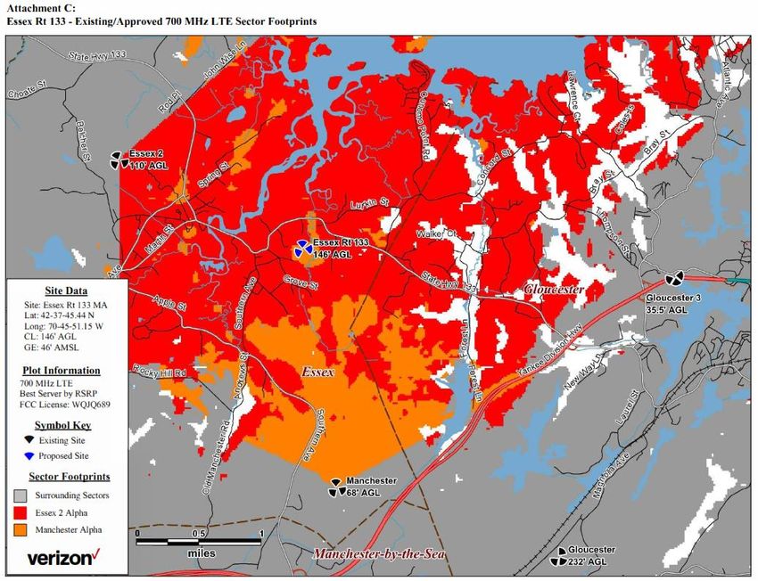
Isotrope, LLC
being so close to the coverage from the Tower Hill facility (“Essex 2”), the coverage from the
proposed location largely eclipses rather than supplements Essex 2 southeast sector. Moving the
proposed tower to the east toward or across the Gloucester line seems to offer a more effective
areawide solution to coverage. If there are any remaining deficits from moving the tower to the
east of the proposed parcel, they can be supplemented by small cells in the town center and/or
at the waterfront or other areas of concentrated activity. If the capacity problem does exist as
claimed, there is no realistic solution using only small cells (CRANs or DAS – see below). Without
any existing structures to consider, a new tower near the Gloucester line would be needed to
improve capacity in Essex and capacity and coverage in Gloucester.

At the proposed site it appears that a judicious relocation about 140 feet easterly could clear the
500-foot setback. A tower height of about 100 feet could be employed to satisfy the property line
setback at either the proposed location or the alternative 140 feet east.

Table 1 summarizes the zoning relief required for the proposed site and several examples of
alternatives. This is intended to illustrate the thinking behind looking for alternatives and is not
intended to be an exhaustive survey of potential alternatives. See Figure 5 and its related
discussion for details.

Table 1 - Characteristics of example alternatives
             Location                    2-mile        500-ft setback      Property Line Setback
                                        Setbacks
 Proposed                              Fails 2      Fails 2 houses      Fails at 150 ft height
                                                                        (passes at approx. 100 feet)
 Proposed offset about 140 feet        Fails 2      Passes              Fails at 150 ft height
                                                                        (passes at approx. 100 feet)
 Haskell parcel                        Fails 1      Passes              Passes at 150 feet height
 Grove Parcel                          Fails 1      Passes              Passes at 150 feet height
 Parcels north of Eastern Ave          Passes       Not likely          Limited likelihood depending
                                                                        on tower height

FCC licenses and RF exposure, FAA clearance
Dispatching the easy confirmations first, TowerNorth’s Exhibits 12, 14 and 15 demonstrate
compliance with necessary FCC licensing, RF exposure limits, and FAA notice requirements,
respectively. The FAA determined the tower will not need to be lit or marked for air navigation
safety. The RF exposure analysis confirms the first tenant’s installation (Verizon’s) will be
compliant with FCC requirements. Future tenants will have similar characteristics such that
Verizon’s safe-side estimate of a maximum potential exposure of 2% of the public safety limit can
be multiplied by perhaps a maximum of four tenant carriers (4 x 2% = 8%) and the facility would
remain compliant with FCC requirements by a large margin.

3
www.isotrope.im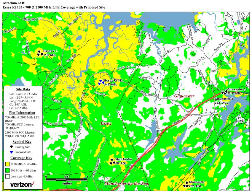
Isotrope, LLC
Balloon test
The photosimulations in Exhibit 4 are based on the balloon test. There is no description of
methodology. The wind conditions and method of verifying balloon height and drift at the time
of setup and the time each photo was taken are not documented, so we can only assume the
balloon was properly representing a 150-foot height centered on the proposed location of the
tower at each photo location.

Also of concern is the lack of a description of the method of generating the simulations. A proper
camera focal length is necessary to represent human perception of the views of the
balloon/tower. Based on our GIS modeling, the camera appears to have about a 28 mm equivalent
focal length. 1 This is substantially wide-angle. Wide-angle views objects appear smaller in the
photo than how they are actually perceived. It is customary to use a 50-55 mm equivalent focal
length to have a normal field of view to represent casual viewer experience.2

Finally, the modeling method is not documented. Some modelers use the balloon as a reference
cross section to estimate the breadth of the simulated tower. The balloon diameter must be
established during the balloon test to use this coarse method of estimation tower proportions.
The resolution of the image can limit the precision of the balloon diameter. Best practices employ
3D modeling and geographic information systems (GIS) to calculate the tower breadth and
simulate properly dimensioned components based on the distance and field of view.

1
  The traditional 35mm film camera is used as a reference for focal lengths. Digital cameras may use smaller
sensors and a crop factor is applied to the actual focal length to obtain the equivalent focal length. We
analyzed the sightlines of photos #2 and #8 and obtained an estimate of the field of view. Field of view
translates to equivalent focal length.
2
  Mr. George Janes, AICP, Executive Director of Environmental Simulation Center, LTD, said in a letter to a
land use board in Shawangunk, NY, January 22, 2008: Most photographs used for photosimulation should
be taken using a normal, or 50mm lens [assuming full-frame format]. This lens has been shown to create an
image where distance relationships are similar to the perception of the human eye. Simply, lenses less than
50mm will make elements in the photograph appear smaller than they would to the human eye, while larger
lenses will make elements of the photograph appear larger. (Janes’ Footnote: Research has shown that there
is variation between people so that any lens between 50 and 55mm is an acceptable lens to represent
distance relationships of the human eye.) If more than two viewpoints are selected for analysis, I recommend
that one or two photosimulations should be done using a zoom lens to simulate the acuity of the human eye
when it focuses on an object in the distance. This zoom lens should be 85mm or larger. Panoramic lenses (or
the use of panoramic stitching) should not be used.

4
www.isotrope.im
Isotrope, LLC
Impact on property value

Our general experience from numerous hearings
We have seen hundreds of real estate valuation reports in wireless facility permitting hearings.
Most are done for applicants, while some are done for opponents. We subscribe to the general
principal expressed by an appraiser working for Verizon in testimony in a North Hampton, New
Hampshire case: If the cell tower is “in your face” it has an opportunity to affect property values.
Two conditions in siting a new tower, in our experience, can lead to “in your face” conditions.
First, residences with ‘million-dollar views’ can be diminished in value by an industrial structure
like a cell tower being erected in a location that compromises the view. Second, when a new tower
is placed in such a way that it creates the sense of looming over residences or dominating the
experience of a neighborhood, it may qualify as “in your face” and impinge on property values.

Appraisal methods lack statistical power to resolve potential issues
Having done statistical modeling in other disciplines, we find the typical appraiser’s methods of
assessing the potential financial impacts of towers to be too coarse, for the most part, to suss out
the subtleties of bad cell tower siting near residences. It boils down to how the presence of the
cell tower is characterized, or not characterized, in an appraiser’s analysis. In general, a broad
assumption about proximity or visibility is made, as stated in the appraiser report in Exhibit 16:
“The research consists of identifying recent sales of homes having either proximity to or a view of
a communication tower with the community considering the development of a new tower.”
(emphasis added) It is not merely whether a cell tower is proximate to or visible to the residence.
More refined methods would be necessary to isolate those situations where the cell tower is “in
your face” or otherwise having the potential to be a turn-off to a substantial proportion of
prospective buyers.

The appraiser also included the results of an informal email survey of 172 appraisers in 15 states,
who uniformly report not experiencing cell towers affecting property values. This is unscientific.
There is no indication of the number of surveys not returned or how the recipients were selected.
The recipients’ responses included in the report show a variety of interpretations of the questions,
and typically very limited scope of any inquiries each has made. There also could be a bias in the
responses in which appraisers believing no effect were likely to respond but appraisers with no
opinion or other opinions were reluctant to respond. The way anonymity of the survey was
guaranteed was not disclosed.

In contrast to the assumption that the responses of 172 email recipients can determine whether
there is a potential impact of any new cell tower on property values, we are aware of examples
that suggest there are conditions where a new tower can affect sales. On the public record, a
residential property purchase offer in New Hampshire was withdrawn when the application to
build a cell tower next door was announced. The property sold for less shortly thereafter. We

5
www.isotrope.im

Isotrope, LLC
have heard some appraisers acknowledge the potential impact of a cell tower on sales prices, only
in the extreme situations where the impact of the tower on resident experience was substantial.
These opinions are consistent with the “in your face” characterization of the previously
mentioned appraiser.

Board may assess visual impact
The photosimulations, assuming they are corrected for focal length, show where and how the
tower would be visible from public ways, illustrating factors such as distance, surrounding visual
clutter and proportions. Residents may submit photos of the balloon test from their private
properties to support their opinions. The Board can judge whether the proposal is obnoxious.

“Fear” of cellular has not been a convincing reason in hearings
Sometimes there is a claim that the mere fear of living near a cell tower (despite the tower being
fully compliant with FCC safety limits) could cause a seller to lose prospective buyers and be forced
to settle for a lower sales price. However, we have heard testimony from real estate agents who
have experienced buyers who routinely check their cell phones as one of the tests of a prospective
place to live. For every person being extra-cautious about living near a cell tower, there appear to
be plenty of buyers looking for good signal quality.

In summation, in the hundreds of cell tower proceedings we have attended, we have not seen
evidence of rampant property value deflation with respect to cell towers. Egregious siting should
be avoided, but mere visibility of a cell tower does not appear to be a factor.

Coverage analysis and “significant gap”
TowerNorth’s claims on Verizon’s behalf

Who is making various assertions?
A significant gap is a legal term, not a technical one. In this section, we will address TowerNorth’s
claims about Verizon’s service in the area. The review is complicated by the nature of the
application. A tower company is applying for zoning relief while carrying a wireless carrier in tow.
It is the carrier (Verizon) whose provision of personal wireless service in the region is being used
to make the argument for need for the facility. Note that it is customary for tower developers to
do the work that benefits the wireless provider. However, tower siting is a competitive
marketplace. If other tower developers or if Verizon itself had an alternative that did not include
TowerNorth, those alternatives should be considered viable as well. In this case, the measure of
an alternative is its viability for Verizon, not necessarily for TowerNorth.

Further complicating our assessment, the RF engineers providing the coverage analysis are
contractors hired to provide evidence for the hearing, as we understand the relationship. They

6
www.isotrope.im
Isotrope, LLC
are not literally “Verizon’s RF engineers.” Ordinarily, this is a minor detail. However, in explaining
how a gap in service is identified, various parties in the application materials make assertions
about “Verizon engineers.” Depending on the assertion, it could refer to the external contractor
(C-Squared Systems or “C-Squared”) hired to show coverage to the Board. Or the reference could
be to the internal Verizon engineers who pull the strings and make the decisions.3

The general claims in TowerNorth’s narrative
On behalf of Verizon, TowerNorth says this on p.8 of the Brief in Support of Application for
Variance:4
       As a result [of using “sophisticated…models”], a limited search area is identified
       by the Radio Frequency Engineer (“RF Engineer”) as the necessary location for a
       wireless facility to ensure the most complete coverage to area residents,
       businesses, and public safety officials.

         Verizon Wireless’ RF Engineer has reviewed call attempts, ineffective call
         attempts, and dropped calls in the search area in which the subject parcel is
         located. This research has confirmed that a “significant gap” in wireless coverage
         exists, requiring the installation of a personal wireless service facility in the search
         area. Verizon Wireless’ RF Engineer has further determined that an installation
         on the proposed telecommunications tower would enable Verizon Wireless to
         close gaps in its wireless coverage.

Based on these assertions, the “gaps” were identified as locations with poor phone calling
performance. A “Verizon Wireless RF Engineer” made this determination.

If the general experience of the participants in the hearing is that making voice calls on the Verizon
network does not seem, anecdotally, to be an issue, the Board could ask TowerNorth to obtain
from Verizon’s RF engineers additional data to verify the assertion for the record. Drive tests that
establish connections and record events such as dropped calls or inability to connect with the
telephone network are commonly used to map where connectivity issues are most pronounced.
Cell-site data on which sectors may be experiencing higher than normal call failures can be used
to show which cell sites are bearing the brunt of a coverage gap. Only the general area of the
“gap” can be inferred from cell site data, depending on where the affected sector 5 is pointed.

Based on this description of a “gap” in service, TowerNorth says this about Verizon Wireless:

3
  This relationship was disclosed in the recent Cellco Partnership v. The Town of Leicester case, in which the
role of C-Squared Systems as presenter, not decider, was clarified.
4
  Page 28 of the consolidated application materials.
5
  Verizon cell sites typically divide the geography into three sectors, each of which serves a 120-degree arc
of the compass. If, say, the southeast sector has an unusually high number of call failure events, there is
likely a “gap” into which many subscribers are driving from the SE sector.

7
www.isotrope.im
Isotrope, LLC
Without the relief requested, Verizon Wireless would be unable to provide
adequate coverage by filling existing significant gap in coverage and capacity,
thereby creating a hardship recognized by federal and state courts interpreting
the TCA. The property is located within the limited geographic area whereby
Verizon Wireless' radio frequency engineers determined that a wireless facility is
required.
In Exhibit 1 – Verizon Wireless Letter of Intent, 6 one Timothy Parks, whom we believe is an
“Engineer IV Specialist - Real Estate/Regulatory at Verizon Wireless,”7 says this:
Verizon Wireless has provided Tower North with its coverage plots and RF Report
that will be filed with Tower North’s application in support of the proposed tower.
Verizon Wireless’ RF Engineer will be present at any required public hearings to
testify and answer any questions that may arise.
This reference to “Verizon Wireless’ RF Engineer” attending the meetings means the contract
engineer hired by Verizon to prepare coverage plots for the hearing. This individual is likely not
the same individual that “reviewed call attempts, ineffective call attempts, and dropped calls in
the search area in which the subject parcel is located” and who “further determined that an
installation on the proposed telecommunications tower would enable Verizon Wireless to close
gaps in its wireless coverage.”
C-Squared Systems’ claims on Verizon’s behalf
We make this distinction between TowerNorth and C-Squared assertions to clarify that the
original work the C-Squared engineer did to model coverage is limited in scope, versus what
he/she may have been told by internal Verizon engineers about performance issues and the
selection of a “search ring.”8 It will be helpful if this person’s testimony avoids conflating the
internal and external engineering roles and provides actionable facts to the Board. C-Squared can
report coverage based on its analysis. C-Squared cannot say what Verizon will or will not accept
without having been told by Verizon.
Page 5 of the C-Squared Systems RF Report9 explains the search process this way:
To find a site that provides acceptable coverage, adequate capacity, and fills the
gaps in service, computer modeling software is used to define a search area. The
6
p.39 of the consolidated application materials.
7
Title of Tim Parks posted on Linkedin. The signed letter does not indicate his affiliation and is not on official
letterhead.
8
The search ring is a general area-to-locate established internally by a wireless carrier and handed off to a
site-acquisition agent to look for a zonable and constructable site. Once a site is identified, the internal
engineers decide whether it is adequate for addressing the objective of the search ring.
9
Exhibit 10 – Radio Frequency Report
8
www.isotrope.imIsotrope, LLC
search ring identifies the area within which a site could be located (assuming
sufficient height is considered) that would have a high probability of addressing
the significant coverage gap and/or meeting the capacity objectives established
by the Verizon Wireless RF (Radio Frequency) engineers.
Note the author’s reliance on the passive voice (“software is used to define a search area”). The
search area definition process is done internally by Verizon and precedes the field agent’s search
and an RF engineer’s final modeling of potential solutions brought back for review. No details
have been provided on Verizon’s original description of the search area and its purpose. Indeed,
the steps from search-area-definition, to site-acq. search, to a suitable site being identified, is
explained in the RF Report:
Once a search ring is determined, Verizon Wireless’ real estate specialists search
within the proximity of the defined area for existing buildings, towers, and other
structures of sufficient height that would meet the defined objectives. If none are
found, then the focus shifts to “raw land” sites. A suitable site must satisfy the
technical requirements identified by the RF engineers, must be available for lease,
and must have access to a road and be otherwise suitable for constructing a cell
site of the required size and height.
Based on our understanding and experience, it is the internal Verizon RF engineers whose
technical requirements must be satisfied. C-Squared Systems engineers work with Verizon
engineers during the zoning process.
Referring to Attachment A in the RF Report,10 C-Squared Systems explains the “deficient areas” of
coverage and calls them “coverage gaps”:
The green and yellow shaded areas [on the existing coverage map] represent the
minimum desired level of coverage for most of this area… As such, the deficient
areas of 700 MHz coverage are defined by the unshaded areas... As shown in this
plot and described in the Coverage and Capacity Objectives section of this report,
portions of Essex are in areas of deficient coverage. These coverage gaps,
particularly at 2100 MHz, include Route 133, downtown Essex and the
surrounding roads, neighborhoods, and retail/dining/business establishments.
10
We have reviewed many C-Squared reports over the years. Provided they continue to use the variables
and assumptions that their engineers employed in maps we have reviewed in detail, the coverage maps in
this application are likely to be reasonable approximations of the coverage at the specified signal levels.
When we replicate their analyses, we typically find our computer models are comparable (never identical)
with mostly minor variations based on the differences in modeling techniques. If there comes a point I this
proceeding where there is evidence the modeling is unreasonably stilted, we reserve the right to perform
more detailed due diligence. For the purposes of this report, based on experience, we conditionally rely on
the provided coverage maps as being reasonable representations of the coverage at the signal levels
presented.
9
www.isotrope.imIsotrope, LLC
Explaining Attachment B in the RF Report, which predicts the additional coverage from the
proposed facility, C-Squared Systems says:
As shown by the additional areas of coverage, the proposed facility will provide
coverage to:
• ~ 0.5 mi (700 MHz) and 1.2 mi (2100 MHz) along Route 133;
• ~ 0.5 mi (700 MHz) along Western Avenue;
• ~ 335 (700 MHz) and ~ 490 (2100 MHz) additional residents;
• ~ 70 (700 MHz) and ~ 240 (2100 MHz) additional employees;
• ~ 260 (700 MHz) and ~ 415 (2100 MHz) additional structures;11
In the C-Squared presentation, the signal level used to indicate “deficient areas” of coverage is
the threshold signal level described this way:
The coverage plots included as attachments show coverage based on RSRP signal
strengths of -95 dBm and above. All other areas (depicted in white) fall within
coverage areas characterized by poor service quality, low data throughput, and
the substantial likelihood of unreliable service.
In the list cited above, the greatest “coverage” gains in Essex are from the new 2100 MHz
coverage. This is because (as detailed below) there already is substantial 700 MHz coverage in
Essex, so the proposed facility is not filling any hole in the provision of Verizon’s service. What is
referred to as a coverage “gap” in 2100 MHz service is more related to the ability to increase
capacity provided to subscribers than to increase coverage in the traditional sense, as detailed
below.
C-Squared metrics compared to TowerNorth’s assertions
Note here that the C-Squared description of the coverage threshold is not specifically related to
voice call reliability. While the non-technical narrative of TowerNorth focuses on call drops, etc,
C-Squared relies on a general characterization of “service quality,” “data throughput” and a
“substantial likelihood” of unreliability.
11
Internal footnotes omitted. The reported street mileage increases at the chosen coverage thresholds are
realistic, as are building counts with the stated caveat buildings are not just residences. This is because
there is a direct relationship between coverage contours and streets and buildings on the map. Comparisons
of population and employee counts are less reliable because Census population is not specified to a small
geographic point like a building or a parcel. Population is grouped in census blocks. This means any time
there is an increase or decrease in covered area, even if that increase or decrease only occurs in unoccupied
areas, the population and employee counts will change.
10
www.isotrope.imIsotrope, LLC The C-Squared performance threshold of -95 dBm RSRP12 is quite robust for voice calling. In filings with the FCC,13 Verizon’s absolute minimum threshold is -117 dBm RSRP. Allowing for the fact that service can be unreliable at the absolute minimum because the user is mobile and signal levels vary by position, C-Squared has used on Verizon’s behalf -105 dBm as a minimum threshold in more remote rural areas. These facts let us conclude that -95 dBm RSRP is generous with respect to the ability to make a reliable voice call. However, there are reasons relating to capacity that carriers target signal levels higher than the minimum necessary for reliable voice calling. Weaker signals waste capacity As the subscriber moves out to the fringe of the influence of a cell site,14 it takes more resources from the cell site to maintain a reliable connection. It is not practical to just turn up the power at both ends as the signal gets weaker. Instead, more bandwidth is used to transmit redundant information and error correction data to ensure packets don’t get lost in the noise. Consequently, when there are many subscribers out at the cell edges (-95 to -105± dBm) their connections waste bandwidth. Fewer total subscribers can be using the cell site at the same time than when all the subscribers are close and getting stronger signal levels. Fewer radio channels available at the cell edge As shown by C-Squared’s use of two radio bands (700 MHz and 2100 MHz) on its coverage maps (Attachments A & B), the 2100 MHz signals are only useful closer to the cell site. This is because higher frequencies do not reach as far, due largely to the greater impact of vegetation and buildings on these frequencies. All subscribers who are out of the influence of the 2100 MHz coverage must use the 700 MHz channel.15 This compounds the problem of weak signals at the fringes – subscribers have fewer channels available to provide them services. Capacity in the best case is sti ll limited Even at a well-working network area with few gaps in coverage, the total number of subscribers attempting to connect to a given cell site and obtain the broadband and voice services they seek may be too great from time to time. Cell sites covering areas with dense human activity will need 12 First, note that signal levels are negative numbers. A -117 dBm signal level is weaker than -95 dBm. Second, “RSRP” is a way of measuring 4G (4th generation) signal levels. It is not comparable to signal levels used with prior generations of technology (3G, 2G). 13 For example, FCC Form 601, Exhibit 1, 700 MHz Construction Notification, Cellco Partnership, Call Sign WQJQ689, REAG001 – Northeast, Block C, Forward Link Budget Analysis table RSRP: -116.8 dBm. 14 Called the “cell edge” by network engineers. 15 Frequencies in the 1900 MHz and 800 MHz bands are also used, but for simplicity, we contrast high (2100 MHz) and low (700 MHz) frequencies to illustrate the point. 11 www.isotrope.im
Isotrope, LLC
to have smaller service areas to avoid capacity crunches than cell sites covering wide areas of
unoccupied land.

These three factors play into some decisions to deploy new facilities even when there is enough
signal strength to provide “coverage.” Carriers like Verizon monitor the demand on their cell sites
and identify trends when the capacity of a cell site will be stressed to the point of unacceptable
reductions in availability of service to a percentage of simultaneous subscribers. If there were a
claim of a capacity crunch, there is data that Verizon relies on to make these determinations that
could be asked for to corroborate the need. (More on this below)

C-Squared secondary analysis
With the first pair of coverage maps representing “coverage” in a more traditional sense (albeit
using a signal level that represents good data service, not necessarily the minimum for just voice
service), C-Squared shows a second set of maps to enable one to infer something about the
capacity issue. The Sector Footprint maps in Attachments C and D are explained this way:

        Attachment C… depicts the areas primarily served by the sectors (a.k.a. signal
        “footprints”) of the surrounding Verizon Wireless macro sites in the area, which
        are shown by the unique color for each particular sector of interest… As demand
        for wireless voice and data services continues to grow, Verizon Wireless manages
        the footprint of each sector so that it can support the demand within the area it
        is primarily serving. In addition to improving coverage to the area, the proposed
        site will also serve existing and anticipated demand in the vicinity and thereby
        offload some of the burden experienced by the surrounding sites.

We said this information allows the reader to “infer” how capacity can be improved. The maps do
not indicate which sectors are under capacity stress. One is allowed to infer from a sector that
has a large “area primarily served” that it may have a capacity problem. The large primarily served
area is not the -95 dBm preferred service level, but is the area from which a subscriber is likely to
be able to make a connection, even if it is an inefficient one. This might be based on -108 dBm or
a similar secondary signal level threshold for mapping purposes. This is why the coverage – or
“primarily served” area is greater on Attachments C and D than the desired coverage is on Exhibits
A and B.

The conclusion of the C-Squared RF Report captures the gist of C-Squared’s assertion on behalf of
Verizon:
        Verizon Wireless determined that the proposed wireless communications facility
        at 73 Eastern Avenue in Essex at an antenna centerline height of 146 feet (AGL)
        will provide additional coverage and capacity needed in the targeted coverage
        areas including key roadways such as Route 133, downtown Essex, and the

12
www.isotrope.im
Isotrope, LLC
surrounding roads, neighborhoods, and retail/dining/business establishments in
the proximity of the proposed site. Without the installation of the proposed site,
Verizon Wireless will be unable to improve and expand their existing 4G LTE
wireless communication services in this area of Essex; (emphasis added)
Isotrope analysis
While the TowerNorth narrative was focused on the classical metrics of call drops and call
availability, the C-Squared report on behalf of Verizon does not make the same case. No call drop
information by drive test or by cell sector is referred to or provided. C-Squared makes a
generalized case for “additional coverage and capacity” with no supporting evidence, leaving the
reader to infer from the Sector Footprint maps. Verizon evaluates capacity demand using several
metrics not reported in the application.16
No lack of signal strength in the traditional sense
There is no coverage issue in the classic sense. Even relying on coverage modeled at the very
conservative threshold of -95 dBm, C-Squared Attachment A reveals there is substantial coverage
in the area of Essex surrounding the proposed facility site. For quick reference, selected
attachments from the C-Squared report are shown below. The full-size versions are in the C-
Squared report.
16
FDV – Forward Data Volume, ASEU – Average Scheduled Eligible Users, AvgAC – Average Active
Connections
13
www.isotrope.imIsotrope, LLC
Figure 1 - C-Squared Systems Attachment A - Existing coverage without proposed coverage
Figure 1 very clearly demonstrates Verizon’s desired level of coverage exists in nearly the entire
area between the existing Essex 2 site and the Gloucester line.17 This is at the aspirational signal
level of -95 dBm.
Figure 2 shows how Essex 2 coverage goes outside of Essex well into Gloucester when the lesser
signal level more consistent with voice calling reliability is used.
Indications that capacity would be increased (whether or not a need is demonstrated)
C-Squared is implying (and asking the Board to infer) from the red area of Figure 2, that Essex 2
southeast sector (“Essex 2 SE”) is under a capacity crunch. This is based on the two factors
obtained from the maps. One factor is the implication that this is a relatively large area of streets
and associated development in both Essex and Gloucester that is too large for Essex 2 SE to have
the capacity to serve. The other factor is the implication that a large proportion of the red area is
below -95 dBm (mostly in Gloucester), which could further draw down the capacity of Essex 2
17
Essex 2 is the name given by Verizon to the tower on Tree Hill.
14
www.isotrope.imIsotrope, LLC with many cell-edge subscribers. However, the application provides no metrics for the number of subscribers likely to be accessing Essex 2 SE or any targets for how many are too many. No data on the actual capacity loading on Essex 2 SE is provided. Figure 2 - C-Squared Systems Attachment C - Existing coverage without proposed, based on unspecified lesser threshold The Board is able to decide whether to accept the applicant’s expectation that the Board will infer the need for a capacity solution from the maps or whether to seek additional corroborating data for the record. 15 www.isotrope.im
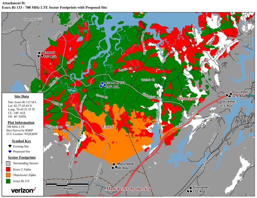
Isotrope, LLC
How the proposal changes capacity to the service area
If capacity needs were demonstrated to the Board’s satisfaction, the Sector Footprint of the
proposed facility is most instructive on the service gains in and around Essex. Figure 3 shows the
proposed facility almost eliminating the need for the Essex 2 southeast sector. In a word, Essex 2
SE is almost eclipsed by the addition of the proposed facility. In this way, Essex 2 SE is reduced to
a minor role not providing much capacity to Essex, as seen by merely serving half-mile segments
of Western Avenue and westerly Rt 133 and a mile segment of Southern Avenue (yellow arrows
annotating Figure 3), plus a few smaller pockets. By nearly eliminating the usefulness of Essex 2
SE, the proposed three-sector tower would only triple the 700 MHz capacity to the area, instead
of quadrupling it. Placing the proposed facility more to the west would give Essex 2 SE a larger
share of Essex to serve, thereby increasing the overall network efficiency of the new site.

Figure 3 - C-Squared Systems Attachment D - Sector footprints with proposed facility (arrows mark limited
effectiveness of existing red sector)

16
www.isotrope.im
Isotrope, LLC
At 2100 MHz, the gains from the proposed tower shown in Figure 4 seem impressive on first
glance (much more yellow on Attachment B than on Attachment A). On closer inspection, vast
areas of salt marsh and estuary are the recipients of the expanded 2100 MHz service. In developed
areas, except for the coverage gain in the marina area on the waterfront by Rt 133, only about a
¼ mile radius from the proposed site obtains -95 dBm or better signal from the proposed site at
2100 MHz.

Figure 4 - C-Squared Systems Attachment B - proposed coverage at -95 dBm

Is the site too close to Essex 2?
As suggested above, it would seem more efficient from both a network perspective and a land-
use perspective to keep Essex 2 SE doing some of the heavy lifting of providing capacity to Essex.
Rather than nearly eclipsing Essex 2 SE with the proposed facility, a different way of expanding
the network could be considered to maintain a useful coverage area for Essex 2 SE while replacing
coverage in the fringe areas of Essex 2 SE. This could involve moving the proposed location more
to the east. It could also involve targeting the center of town, if that area is indeed is contributing
to a capacity crunch, with small-cells in key locations. The latter is discussed below in response to
a separate inquiry of the Board.

17
www.isotrope.im
Isotrope, LLC

First summation
To this point we have shown how there already is existing strong signal in most of northeastern
Essex. TowerNorth misses the boat with its explanation about dropped calls and such supposedly
occurring as a result of a lack of signal, i.e. a lack of coverage. It is not likely that drive tests or cell
sector data will support TowerNorth’s assertion.

We have shown how the proposed facility would multiply the capacity available to the area
between Essex 2 and the Gloucester line, by adding three sectors and almost eclipsing the Essex
2 SE sector. Locating the proposed facility farther east would likely increase the division of services
between the proposed and the existing sectors in a more balanced way.

We have determined that if the implications of a capacity need are true, they could be supported
by more specific evidence that Verizon has provided to finders of fact in other siting applications.
The Board can rely on the inference offered by the C-Squared report, or it can decide that more
facts are needed to corroborate the implication of a capacity need.

As the complexity of this analysis reveals, it is not a simple case of deciding whether there is a
significant gap in Verizon coverage or not. Service based on the traditional metric of “coverage,”
i.e. signal strength for voice calling, appears to be nearly complete in this part of Essex. The federal
rubric has evolved. A decade ago when broadband data services became a design factor, there
were court cases that attempted to link the provision of data services with the 1996
Telecommunications Act (“TCA”) prevention of the effective prohibition of the provision of
personal wireless (telephone)18 services. The ping-pong back-and-forth of data services as either
information services or telecommunications services at the FCC complicated the regulatory space.
Then the recent FCC determination that municipalities must not “materially inhibit” carriers in
their efforts to provide services has increased rather than decreased regulatory certainty. As we
are not providing legal advice, the best we can do is educate the Board about the technical facts
so it can make a reasoned judgment under the advice of counsel.

Alternatives
To the extent the Board requires information about alternatives to the proposed facility, we start
with the following assumptions:

18
  The requirement was based on the fact that the protected personal wireless services were commercial
mobile radio services that were connected to the dial-by-number telephone network. Data services were
not contemplated by this part of the TCA.

18
www.isotrope.im
Isotrope, LLC
• An alternative should be less objectionable either in terms of the amount of zoning relief
requested and/or with respect to reducing the community impact (visual, mostly) of the
proposed versus the alternative solution.
• An alternative could be a solution that the applicant, TowerNorth, could bring to fruition
for Verizon’s benefit, but not necessarily so. An alternative tower developer with an
alternative site, or Verizon itself may have access to an alternative not available to
TowerNorth.
• Verizon is in command of the choice to use small cells when and where it pleases.
TowerNorth’s ministrations to the contrary will be expected, but without a firm response
from Verizon itself, all other opinions are merely supposition.
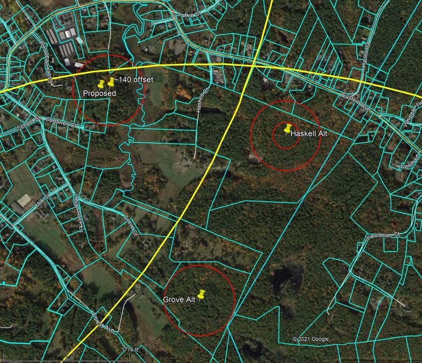
Example locations meeting more setbacks
Below, Figure 5 is an aerial photo from Google Earth, overlaid with property boundaries and some
additional markings. The two yellow rings are the 2-mile radiuses from the nearest towers. The
orange line is the Gloucester border.
The proposed tower site is the left of two push-pins at the proposed parcel, upper left. Other sites
are selected for illustration. Large red circles are 500-foot residential radiuses. One small circle is
a 187.5-foot property line setback for a 150-foot tower.
The discussion below is to illustrate how alternatives can be brought for consideration. These
alternatives do not represent all the potential alternatives. They have been identified as
possibilities based on the assumptions above. Additional analysis of coverage, tower height,
availability, constructability, and such would be necessary. It is not incumbent on Isotrope or the
Board to identify all alternatives for the applicant to consider.
Height reduction
The first alternative is one that requires no map. A reduction in tower height at the proposed
location can be considered, if it can materially address visual impacts or reduce the amount of
zoning relief required. The photosimulations, once validated, can be used to decide if a reduction
in tower height will make a meaningful difference in visual impact to the community. A reduction
in tower height can also reduce or eliminate the noncompliance with the property line setback.
Verizon could be asked to provide a height assessment, which typically provides comparative
coverage plots at 20-foot increments such as 150, 130, 110 and 90 feet.
While TowerNorth is in the tower business, benefitting from multiple tenants on one tower.
Maximizing tower occupancy at the expense of community impact is not specifically required by
the bylaw. Collocation requirements are often included in bylaws, but not in this case. Instead,
the 2-mile separation requirement forces applicants to consider using existing towers or other
19
www.isotrope.imIsotrope, LLC alternative approaches before seeking a variance of the 2-mile separation requirement. The bylaw does not require a new tower to be as high as possible to maximize potential collocation. The optimum height can be selected based on weighing the relative impacts of potentially more, shorter, potentially less visible towers against taller higher-capacity towers. Moreover, an approximately 100-foot tower could be positioned to meet the property line setback by moving it about 4 feet north. This location is within two 2-mile tower radiuses. Shift easterly The second alternative example relocates the tower to a position about 140± feet easterly of the proposed position (pushpin “140 offset”). Figure 5 - Aerial photo markup of example alternatives (yellow curves are 2 miles from existing towers) Based on the applicant’s site plans, this location can satisfy the 150-foot wetland setback for towers. It might require non-tower construction within the 150-foot buffer, or asymmetrically 20 www.isotrope.im
Isotrope, LLC
placing the compound with the tower off center, if an interpretation of the bylaw requires. It
appears that with careful tower placement, the 500-foot residential buffer can be satisfied. The
property line setback will remain about the same as the 121 feet proposed. A 100± foot tower
may be able to meet the property line setback.19 This location is within two 2-mile tower radiuses.

The third alternative example is on a large parcel off Haskell Street, #137-24. There seems to be
plenty of space to avoid mapped wetlands, meet the property line setback and the 500-foot
residence setback. This location is within only one 2-mile tower radius.

The fourth alternative example is on a large parcel off Grove Street, #139-6. There seems to be
plenty of space to avoid mapped wetlands, meet the property line setback and the 500-foot
residence setback. This location is within only one 2-mile tower radius.

Other parcels in the area might be satisfactory with various needs for variances. The examples
above are not a comprehensive review. The area north of Eastern Avenue within 1600 feet r more
of the Gloucester line is outside both 2-mile separation zones and could use closer scrutiny.
Parcels tend to be narrower, so it may be a challenge to satisfy the 500-foot and the property-line
setbacks.

What we see with the opportunities for siting a conventional cell tower in the northeastern Essex
area are that it is likely the 2-mile tower separation will require at least one variance but it is
possible to obtain compliance with the 500-foot and the property line setbacks. Outside the 2-
mile separation zones, these other setbacks may need varying. It is a matter of identifying which
of any potential alternative locations20 will provide a good combination of

     1.   Reducing the amount of relief required
     2.   Minimizing visual impacts
     3.   Providing enough coverage to offload capacity demand from Essex 2 SE
     4.   While allowing Essex 2 SE to continue to bear a reasonable capacity load (and not be
          eclipsed by the new facility)

The foregoing assumes that there is adequate cause based on substantial evidence to grant
whatever variances are required at the optimal site and tower height.

19
   We do not provide coordinates because these are hypothetical sites that should be selected by a
proponent after considering all the variables on their own GIS tools.
20
   We are not recommending whether to require the facility to be at an alternative location. Based on the
Board’s assessments of impact and need for the proposed tower, the Board can decide whether there is a
need to look more deeply at alternatives.

21
www.isotrope.im
Isotrope, LLC Alternatives not involving new towers Not being as familiar with the local territory as residents are, we rely on the public process to raise attention to any existing towers the applicant may have missed, or other tall structures that potentially clear the surrounding tree height such as stanchions, steeples and the like. The Board also requested comment on the potential use of small cells to address all or part of the claimed coverage need. Small cells are called small wireless facilities by the FCC. Small wireless facilities must comply with some maximum volume and dimensional requirements. 21 Among other locations, small wireless facilities can be placed in the public way on utility poles. Verizon has installed hundreds of small cells on utility poles in the metropolitan Boston area. These are generally placed where there may be existing coverage, but capacity of existing cell sites is at issue. Verizon, not TowerNorth, would decide whether to implement small cells to address coverage needs in Essex. C-Squared says Verizon’s coverage goal of the proposed tower is key roadways such as Route 133, downtown Essex, and the surrounding roads, neighborhoods, and retail/dining/business establishments. The existing coverage in the town center is primarily 700 MHz coverage. The proposed coverage in the town center is primarily 700 MHz coverage, mostly from the proposed facility eclipsing the existing coverage. C-Squared, in its assertion that 2100 MHz has “coverage gaps” where 700 MHz coverage is present, says, These coverage gaps, particularly at 2100 MHz, include Route 133, downtown Essex and the surrounding roads, neighborhoods, and retail/dining/business establishments. It should be noted that when the proposed facility is added, the 2100 MHz coverage increases to the waterfront area by Route 133 and to a ¼-mile radius from the tower, along Rt 133. The “downtown Essex” area does not get new 2100 MHz service. To improve capacity in the Martin Street (Rt 22)/Main Street (Rt 133) “downtown” area, Verizon has the option of placing one or more small cells at strategic locations along these streets. Likewise, the waterfront area is wide open without vegetation and is a superb candidate for a small cell. A cell tower would still likely be needed near or across the Gloucester line to cover the residential areas. Relocating the proposed tower east of the proposed site is not expected to 21 Distributed Antenna Systems (“DAS”) are small cells connected by a dedicated fiber backbone to a local hub called a base station hotel. DAS is not as popular as it was because of the need to run dedicated fiber. The latest small cells can use commercial data connections provided by telecom services to connect directly to the “cloud.” No base station hotel is required. DAS is not a likely solution in this area of Essex. DAS is usually provided by a third party neutral host provider, while cloud radio access network (“CRAN”) small cells are typically installed by the carrier that needs it. 22 www.isotrope.im
Isotrope, LLC
create any performance issues at the town center because of the existence of Essex 2 SE coverage.
However, if there were need for more capacity here, one or more small cells would be a good
supplement.

Residents’ legal brief
We also reviewed an April 21st letter to the board from an attorney representing some Essex
residents (the “Brief”). The Brief raises concerns about how TowerNorth is asserting its claim for
several variances. We often see that because a tower can go in a variety of locations to serve its
purpose, boards find it difficult to ascribe any lot-specific limitations not relating to the underlying
district to the inability to site a tower there. In general, we did not find a location near and easterly
of the proposed tower where no variances would be required. We did identify several example
sites where fewer variances would be required and/or potentially less visual impact might occur.

The test of a significant gap is a legal interpretation for which this report provides underlying
education and facts. It is complicated. The design presented by C-Squared is for a capacity
improvement. The proof of a capacity need is indeed lacking. The legal framework for deciding on
variances in such circumstances is out of our scope.

We have provided a dissertation on coverage analysis in both coverage and capacity situations.
While we also observed C-Squared’s selective use of different signal level thresholds, we provided
a nuanced explanation. This sorts out the different signal strengths used by C-Squared to present
coverage and capacity features of existing and proposed facilities. -95 dBm is not a limit of
coverage in the voice calling context.

If a “significant gap” is legally applicable to other than simple signal strength issues, we have
provided an explanation of what is lacking in direct evidence of, for want of better terminology, a
“capacity gap.”

23
www.isotrope.im
Isotrope, LLC
Conclusion
Please see the Executive Summary at the front of this report. The Board can consider whether to
seek:
    • additional capacity evidence
    • coverage/capacity evaluations of any alternatives chosen by the Board for consideration,
        including changes of tower location and tower height
    • due diligence on availability and constructability of likely alternative sites, on and off the
        proposed parcel
    • The methodology of the balloon test and photosimulations should be validated and any
        corrections to the reporting be submitted

The Board does not need to obtain Verizon concurrence on the use of small cells in targeted areas.
It should be sufficient to simply be aware that these solutions can complement future capacity
needs in and near the town center, whether or not an alternative tower site causes an immediate
need for them.

David Maxson, WCP
June 8, 2021

24
www.isotrope.im
You can also read