An Aerial Mixed-Reality Environment for First-Person-View Drone Flying - MDPI

Page created by Billy Deleon
 
CONTINUE READING
An Aerial Mixed-Reality Environment for First-Person-View Drone Flying - MDPI
applied
           sciences
Article
An Aerial Mixed-Reality Environment for
First-Person-View Drone Flying
Dong-Hyun Kim , Yong-Guk Go                    and Soo-Mi Choi *
 Department of Computer Science and Engineering, Sejong University, Seoul 05006, Korea; d@sju.ac.kr (D.-H.K.);
 lattechiffon@sju.ac.kr (Y.-G.G.)
 * Correspondence: smchoi@sejong.ac.kr
                                                                                                     
 Received: 27 June 2020; Accepted: 3 August 2020; Published: 6 August 2020                           

 Abstract: A drone be able to fly without colliding to preserve the surroundings and its own safety.
 In addition, it must also incorporate numerous features of interest for drone users. In this paper,
 an aerial mixed-reality environment for first-person-view drone flying is proposed to provide an
 immersive experience and a safe environment for drone users by creating additional virtual obstacles
 when flying a drone in an open area. The proposed system is effective in perceiving the depth
 of obstacles, and enables bidirectional interaction between real and virtual worlds using a drone
 equipped with a stereo camera based on human binocular vision. In addition, it synchronizes the
 parameters of the real and virtual cameras to effectively and naturally create virtual objects in a
 real space. Based on user studies that included both general and expert users, we confirm that the
 proposed system successfully creates a mixed-reality environment using a flying drone by quickly
 recognizing real objects and stably combining them with virtual objects.

 Keywords: aerial mixed-reality; drones; stereo cameras; first-person-view; head-mounted display

1. Introduction
      As cameras mounted on drones can easily capture photographs of places that are inaccessible to
people, drones have been recently applied in various fields, such as aerial photography [1], search and
rescue [2], disaster management [3], and entertainment [4]. Commercial drones are controlled in the
third-person or first-person view (FPV), i.e., the view of an unmanned aircraft. In the third-person
view, a pilot can view the entire drone in relation to its surroundings during a flight. However, it is
difficult to estimate the position and direction of a drone relative to nearby objects to avoid obstacles
when flying a drone from a third-person view because the range of human stereoscopic vision is
limited to approximately 90 m, and the effective range is considerably smaller. More advanced drone
control systems allow pilots to visualize that they are onboard their drones. FPV drones, such as
FatShark [5] and Skyzone [6], are remotely controlled using an onboard camera and FPV goggles.
These drones send monocular video feeds via analog signals from the camera to the pilot’s goggles
with a limited field of view of 35◦ –43◦ and resolutions of a video graphics array (640 × 480) or wide
video graphics array (800 × 600). Professional drone pilots can safely fly an FPV drone by estimating
distances between the drone and obstacles depending on their experience; however, it is not easy for
novice pilots to fly an FPV drone while avoiding collisions with obstacles due to the low transmission
rate, poor reception, fast speed, and obstacles.
      According to a remote robot control experiment [7], FPV control using a stereo camera yields fewer
errors than using mono images. Hence, the first-person experience could be improved by utilizing
more advanced techniques, including stereo views and wide fields of views. Moreover, safer and more
exciting environments could be provided to prevent drone crashes and reduce collisions with obstacles,
thereby protecting drones and their surroundings. Our research was motivated by the need to provide

Appl. Sci. 2020, 10, 5436; doi:10.3390/app10165436                               www.mdpi.com/journal/applsci
An Aerial Mixed-Reality Environment for First-Person-View Drone Flying - MDPI
Appl. Sci. 2020, 10, 5436                                                                          2 of 17

safe, inexpensive, and fun environments for flying a real drone, rather than using a virtual reality
(VR) drone flight simulator. To achieve this purpose, an FPV drone can be combined with immersive
mixed-reality (MR) technology, where physical and virtual objects co-exist and interact in real time.
Stimulating drone racing or training tracks can be created by mixing free-form virtual objects with
simple physical obstacles, which may be difficult or expensive to make in the real world.
      A novel aerial MR environment based on stereo vision for flight training is proposed in this study.
We utilized a stereo camera to capture real-world scenes during flight to improve depth perception,
and introduced an MR environment that combines virtual three-dimensional (3D) objects with a stereo
video stream from the drone camera in real time to control the difficulty level depending on a pilot’s
skill. The proposed aerial MR environment enables more accurate depth perception, which is important
for determining the direction and orientation of the drone when passing through an obstacle, and
facilitates engaging interactions with physical and virtual objects.
      The main contributions of this study are as follows.
•     We propose a new aerial MR environment using an FPV drone with a stereo camera to provide
      users with a safe and engaging flight environment for flight training. The stereo camera improves
      the accuracy of the pilot’s distance estimation from binocular disparities, and a head-mounted
      display (HMD) with a wide field of view increases immersion.
•     Different MR environments for drone flying can be created easily by placing several drone flags in
      the real world. The flags are recognized by machine learning techniques and virtual objects are
      synthesized with a real scene when detecting the flags during flight.
•     The proposed system is evaluated on the basis of user studies to compare the experiences of using
      our FPV-MR drone system with a VR drone flight simulator.
     The remainder of this paper is organized as follows. Section 2 presents a review of related works.
Section 3 outlines the proposed system and describes the composition of the proposed system. Section 4
summarizes the user studies conducted to evaluate the proposed system. Finally, Section 5 presents
the conclusions and future research.

2. Related Work

2.1. Uses of Drones with Cameras
      Drones are operated by mounting a mono or stereo camera depending on the purpose of
use. Methods to accurately track people or objects using drones with a mono camera have been
investigated [8,9]. In previous research [8,9], object tracking and control methods for various objects
located in the suburbs were proposed. The systems used were aimed at tracking objects specified by a
user while maintaining a certain distance to the objects. To capture the panoramic views of landmarks,
Xie et al. [10] proposed a design tool for drone trajectories that creates a drone flight plan in advance
using quadrotor drones equipped with a high-quality mono camera. However, the tool cannot cope
with unexpected situations during flight because it uses a rough 2.5D model for landmarks visited
by the drone as well as additional obstacles. By contrast, Nägeli et al. [11] and Galvane et al. [12]
proposed a method for automatically planning the path of a quadrotor in real time in a dynamic 3D
environment while satisfying the physical constraints of cinematographic and multiple quadrotors.
In their study, control functions for cinematographic drones were provided to perform specific tasks with
dynamic targets. In the entertainment field, racing drones are garnering attention. Drone racing [13]
is a sport event in which operators fly drones quickly in a complex environment while passing them
through various predesigned obstacles. The operators can feel as if they are in fact flying through
an FPV flight because of real-time video feeds. Autonomous driving drone racing competitions [14]
have also been held, in which vision-based autonomous drones were flown around a track comprising
predesigned gates. In autonomous drone racing, a drone is required to fly through the gates quickly
without any collision. To identify drone racing gates, Jung et al. [15] presented a reliable method using
deep learning from images acquired through a mono camera onboard a drone.
An Aerial Mixed-Reality Environment for First-Person-View Drone Flying - MDPI
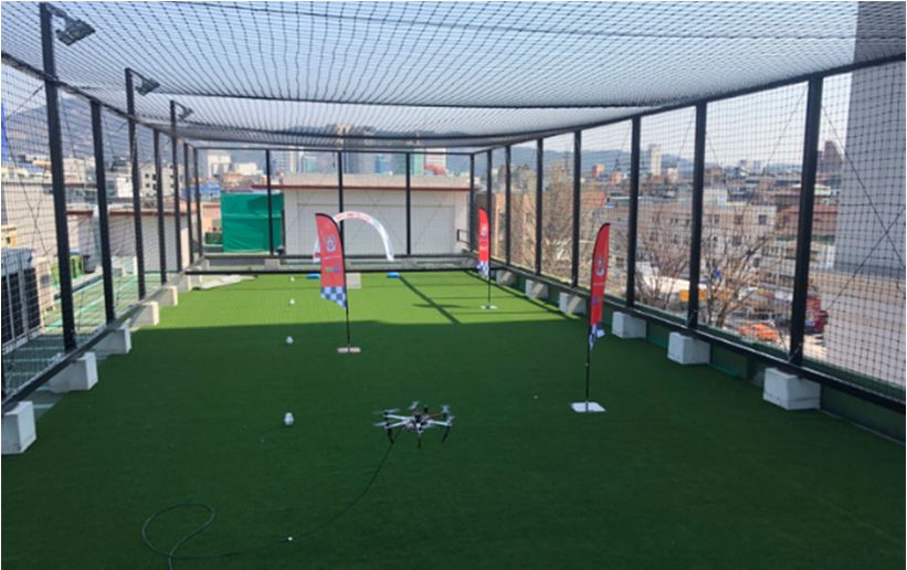
Appl. Sci. 2020, 10, 5436                                                                            3 of 17

     A stereo camera is mainly used to capture photographs of a 3D space because it can capture
the color and depth information of all of the pixels of two separate scenes. Because drones are
being spotlighted as a method to access spaces that are inaccessible to people, the use of a stereo
camera with drones has been proposed in some recent studies to enhance the ground control and
autonomous driving abilities of drones, or to reproduce panoramic outdoor views or buildings in three
dimensions. Furthermore, stereo cameras have been investigated in relation to an autonomous driving
drone system for disaster rescue [16,17], and a reliable ground control system for autonomous system
failure has been proposed [18]. To improve the ground control experience of drones, Nikolai et al. [18]
attached a stereo camera to a drone and proposed a complete immersive setup that provided an
FPV in three dimensions through a VR HMD. In this study, it was demonstrated through expert
experiment that users controlling a drone successfully performed take-off, flight, and landing while
wearing a VR headset; moreover, the incidence of simulator sickness for general users was investigated.
This approach enabled an accurate remote control by providing higher perceptual accuracy during
flight. Using stereo images and global positioning system (GPS)/inertial navigation system data,
Akbarzadeh et al. [19] proposed a 3D reconstruction method for an urban scene; however, it failed
in real time because of limited processing speed. Through hardware development, Geiger et al. [20]
suggested a pipeline for implementing a 3D map from a high-resolution stereo sequence in real time.
Research regarding methods for 3D reconstruction from stereo video streams has been expanded using
drones. Zhang et al. [21] proposed the use of drones in archeology. In their study, drones with a
stereo camera produced 3D models of a large cave and entered spaces that are not easily accessible by
humans to find ruins and provide new insights into archeological records. Furthermore, Deris et al. [22]
suggested 3D scanning and reproduction methods for outdoor scenes and buildings using drones with
a stereo camera. However, although drones with cameras are being actively researched in the fields of
films, disasters, 3D reconstruction, and autonomous driving, studies regarding applications that create
an MR environment in the air using a stereo camera and a drone are rare.

2.2. Virtual and Augmented Reality for Drones
     Creating virtual and augmented reality (AR) environments for drones is a recent challenge.
Drone manufacturers, including DJI and Parrot, have released low-priced easy-to-control drones,
and low-priced VR/AR headsets have recently been launched. Hence, many interesting applications
combining drones and VR/AR technologies have been developed. Using drones with cameras and
HMDs, a user’s view can be expanded to places that are difficult or impossible to capture. Erat et al. [23]
suggested using a see-through display for flight control in a narrow or limited environment. This system
simulates X-ray vision in a walled environment to enable users to naturally view and explore hidden
spaces. Ai et al. [24] proposed a system that allows users to interactively control a drone and visualize
the depth data of photographed parts in real time using a point cloud, which can be viewed on a
VR HMD.
     Research has been conducted that mixed real scenes from drone cameras with virtual objects.
For large-scale AR, Okura et al. [25] proposed a hardware configuration and virtual object overlay
methods for aerial photography using a multidirectional camera and a large airship. Aleotti et al. [26]
presented a haptic augmented interface to detect nuclear sources outdoors and verified their locations
using a fixed ground camera. Zollmann et al. [27,28] proposed a drone navigation method for 3D
reconstruction of an area of interest using a drone equipped with a high-resolution camera and AR.
This is an AR system that complements a supervisor’s view through relevant information for its
autonomous driving plan and real-time flight feedback. Sun et al. [29] developed a video augmentation
system using differential global positioning system (DGPS) sensors for remote disaster monitoring.
In AR research regarding construction environment monitoring, a system for the midair 3D
reconstruction of a construction site has been presented, where data of interest are captured and then
overlaid with those of an actual site on a mobile device.
An Aerial Mixed-Reality Environment for First-Person-View Drone Flying - MDPI
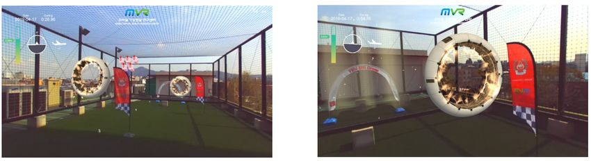
Appl. Sci. 2020, 10, 5436                                                                            4 of 17

     However, in the abovementioned studies, the locations of augmented objects are occasionally
mismatched with the locations in the physical environment, which can confuse users. This is because
virtual object mixing using a mono camera or GPS can easily generate errors from the sensors.
Furthermore, their main objective is not to provide an immersive experience for users but to provide
information to users through a two-dimensional (2D) screen interface or 3D point-cloud-based VR.
As previously mentioned in Section 2.1, drones with stereo cameras have been investigated for
autonomous driving [16–18] and 3D reconstructions [19–22], and Nikolai et al. [18] proposed a
similar immersive setup using a VR HMD but only for a ground control purpose. In addition,
the recent studies [25–28] discussed in Section 2.2 combined advanced AR technologies with drones to
superimpose valuable graphic data over the images that come from the cameras of the drones. MR is a
hybrid of physical and virtual worlds, encompassing both AR and augmented reality via immersive
technology. Stereo cameras are appropriate for generating an immersive MR environment; however,
no previous study exists in which stereo cameras mounted on drones are used to create an aerial MR
environment and expand the ground control experience of drones using a VR HMD.

2.3. Object Recognition and Immersion Measurement in Mixed Reality
      To create an MR environment based on the real world, it is crucial to accurately match the locations
of virtual objects to be merged with those of real objects. In other words, real objects, which are the
criteria for positioning virtual objects to be rendered, must be recognized accurately. As an example,
virtual objects, such as trees and obstacles, can be dynamically created in the MR environment when
a drone recognizes flags or water bottles in real scenes. Furthermore, a stable MR system must
interact with users in real time to eliminate a sense of difference with the real world. In fact, users are
more sensitive to visual mismatches than to virtual objects not moving in the same manner as real
objects because the matching errors of virtual objects result in an unnatural MR. Moreover, the MR
environment for drone flights from an FPV requires faster and more accurate identification when
deciding the locations of virtual objects to be mixed with real scenes because flying drones change
their locations and directions more dynamically in each moment than human vision.
      Object recognition has developed rapidly in the field of computer vision because it can be used in
major applications, such as intelligent vehicle control, monitoring, and advanced robots. The technology
for object recognition has been investigated mainly for pedestrian detection [30] and face recognition [31].
This technology extracts the features of objects using scale invariant feature transformation [32] and
histogram of oriented gradient [33] methods, and uses them for identification. However, methods for
solving classification problems are slowly being developed, and their performance has improved owing
to the use of ensemble or complementing past studies [34,35]. Recently, Alex et al. [36] achieved a
significant performance improvement in the ImageNet Large-Scale Visual Recognition Challenge using
AlexNet based on a convolutional neural network (CNN). Subsequently, CNNs for object recognition
have been investigated actively. Consequently, region-based CNNs (R-CNNs) using selective search
have been proposed, and fast R-CNN [37] and faster R-CNN [38] with higher speeds have been released.
A fast R-CNN cannot perform real-time object recognition because of its slow processing speed of the
region proposal method operated outside the CNN. However, the faster R-CNN improves the accuracy
and speed by using the region proposal algorithm inside the CNN. Consequently, real-time recognition
with high accuracy is enabled. In this study, the faster R-CNN proposed by Ren et al. [38], which can
perform accurate object recognition in real time, was used as the object recognition method.
      Previous studies have not precisely defined user experience components or the method to
measure them in an immersive virtual environment; however, they have been studied indirectly
in flight simulators [39] and game fields [40]. Simulator sickness among aircraft pilots has been
mainly investigated. The simulator sickness questionnaire (SSQ) is the current standard for measuring
simulator sickness. It is recognized as an excellent single measure because it provides each indicator of
overall symptoms. The game engagement questionnaire (GEQ) has been widely used as a measure of
user engagement in games. Based on these, a more accurate method of measuring immersion in a
An Aerial Mixed-Reality Environment for First-Person-View Drone Flying - MDPI
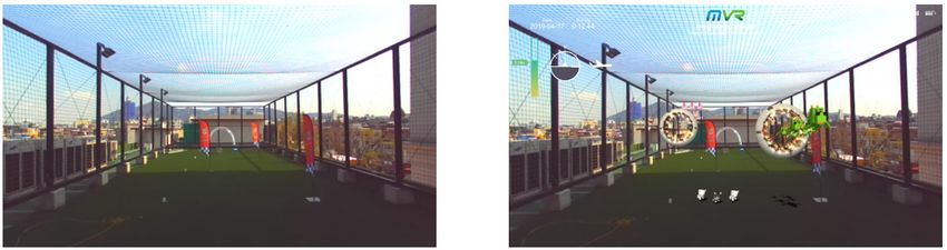
Appl. Sci. 2020, 10, 5436                                                                                                   5 of 17

 Appl. Sci. 2020, 10, x FOR PEER REVIEW                                                                                    5 of 17

virtual environment [41] was proposed, in which the reliability of the questionnaire was improved
  virtual environment [41] was proposed, in which the reliability of the questionnaire was improved
using 10 rating scales and 87 questions. Questions corresponding to immersion, presence, emotion,
  using 10 rating scales and 87 questions. Questions corresponding to immersion, presence, emotion,
flow, judgment, usability, and experience were posed and answered based on 10 scales. Furthermore,
  flow, judgment, usability, and experience were posed and answered based on 10 scales. Furthermore,
user immersion was measured with a simple questionnaire that combined the GEQ [42] and SSQ [39]
  user immersion was measured with a simple questionnaire that combined the GEQ [42] and SSQ [39]
to verify the efficiency of the proposed framework.
  to verify the efficiency of the proposed framework.
3. Mixed Reality for Drones
 3. Mixed Reality for Drones
3.1. System Overview
 3.1. System Overview
      In this paper, an immersive MR environment for drone flying is proposed to expand the ground
controlInexperience
          this paper, of
                      androne
                         immersive  MR environment
                               operators.             for virtual
                                          It synthesizes  drone flying is proposed
                                                                  environments     to expand
                                                                                such          theand
                                                                                      as forests  ground
                                                                                                     cities
 control experience of drone operators. It synthesizes virtual environments such as forests and cities
with a wide empty space in which a drone can be flown safely. Figure 1 shows the software architecture
 with a wide empty space in which a drone can be flown safely. Figure 1 shows the software
of the proposed system. The stereo camera mounted on the drone recognizes predefined objects from
 architecture of the proposed system. The stereo camera mounted on the drone recognizes predefined
the input image. The 2D coordinates of the recognized objects are mapped to three dimensions and
 objects from the input image. The 2D coordinates of the recognized objects are mapped to three
mixed with virtual 3D objects using depth information from the stereo camera. Because some virtual
 dimensions and mixed with virtual 3D objects using depth information from the stereo camera.
objects in this MR environment are generated dynamically based on real objects, the locations of
 Because some virtual objects in this MR environment are generated dynamically based on real objects,
the virtual objects can be changed by moving the locations of actual objects, such as flags or bottles,
 the locations of the virtual objects can be changed by moving the locations of actual objects, such as
in the real world. Object recognition and the mixing of virtual and real scenes are performed using a
 flags or bottles, in the real world. Object recognition and the mixing of virtual and real scenes are
wearable VR backpack PC. The mixed scene is stereo rendered and is shown to the user through an
 performed using a wearable VR backpack PC. The mixed scene is stereo rendered and is shown to
HMD connected to the user’s VR backpack.
 the user through an HMD connected to the user’s VR backpack.

                                 Figure1.
                                 Figure 1. Software
                                           Software architecture
                                                    architecture of
                                                                 of the
                                                                    the proposed
                                                                        proposed system.
                                                                                 system.

 3.2.Aerial
3.2.  AerialMixed
            MixedReality
                  RealityUsing
                         Using aa Drone
                                  Drone with
                                        with aa Stereo Camera
        Theproposed
      The    proposed system
                          system usesusesaastereo
                                             stereo camera
                                                       camera   (StereoLabs’
                                                                   (StereoLabs’ ZED   mini,
                                                                                    ZED      San Francisco,
                                                                                           mini,              USA [43])
                                                                                                   San Francisco,     USAwith  [43])
  a baseline
with           distance
      a baseline          of 64 mm,
                     distance     of 64which   is the binocular
                                         mm, which                   distancedistance
                                                         is the binocular        of an average
                                                                                           of an adult.
                                                                                                  average Asadult.
                                                                                                             shownAs  in Figure
                                                                                                                           shown
in2,Figure
    the ZED  2, stereo
                the ZED camera
                             stereomounted
                                      cameraon   the drone
                                               mounted        onisthe
                                                                   used  for passive
                                                                       drone    is used3Dfordepth   estimation
                                                                                              passive           andestimation
                                                                                                         3D depth     provides
  depths
and         of 0.7–20
      provides     depthsm of with   an accuracy
                                 0.7–20   m with an  of accuracy
                                                          0.4–1 mm.   of For
                                                                         0.4–1outdoor
                                                                                  mm. For applications,    a ZED camera
                                                                                              outdoor applications,        a ZED  is
  significantly    better  than   a Microsoft   Kinect,    which    is an  active   3D  depth   estimator
camera is significantly better than a Microsoft Kinect, which is an active 3D depth estimator using         using  an  infrared
anlaser. In this
    infrared       study,
                laser.  In athis
                               ZED    camera
                                   study,      wascamera
                                           a ZED      mounted    wasat mounted
                                                                       the front at of the
                                                                                       a DJI   F550ofhexacopter
                                                                                            front     a DJI F550 (Shenzhen,
                                                                                                                    hexacopter
  China)   to  observe    the   flight  path  of the   drone     from   the   FPV.   The  drone
(Shenzhen, China) to observe the flight path of the drone from the FPV. The drone has a maximum    has   a maximum       load of
load of approximately 600 g and is appropriate for aerial photography. In the current system, theZED
  approximately       600   g  and   is appropriate     for    aerial  photography.      In  the  current   system,   the      ZED
  camerawas
camera      wasconnected
                  connectedtotoa amobile
                                      mobilePCPCthrough
                                                   througha aUSB  USB3.03.0interface.
                                                                             interface.Therefore,
                                                                                         Therefore,the thedrone
                                                                                                           dronecancanlift
                                                                                                                        lifta a1010m
  m cable
cable   andand    capture
              capture        videos
                         videos       with
                                   with     excellent
                                         excellent    airairstability
                                                              stabilitybecause
                                                                        becauseititsends
                                                                                      sends video
                                                                                              video streams
                                                                                                     streams using
                                                                                                               using aaspecial
                                                                                                                           special
USB 3.0 cable, known as a repeater cable. In an environment where wireless transmissionisispossible
  USB   3.0 cable,  known      as a repeater  cable.   In   an  environment      where   wireless   transmission        possible
  andthe
and    theweather
            weatherisisfine
                          fineand
                                andnotnotwindy,
                                           windy,thethe camera
                                                         camera can can be
                                                                        be connected
                                                                             connected to to aa smaller
                                                                                                smaller drone.
                                                                                                          drone. In
                                                                                                                  Inthis
                                                                                                                     thisdrone
                                                                                                                             drone
system, a stereo camera simulates the human binocular vision of actual scenes. It provides FPVflight
  system,   a stereo   camera    simulates   the  human      binocular    vision   of actual  scenes.  It provides  FPV      flight
  scenesthrough
scenes    throughthe  theOculus
                            Oculus Rift
                                      Rift CV1
                                           CV1 headset
                                                 headset connected
                                                              connected to  to the
                                                                               the user’s
                                                                                    user’s VR
                                                                                            VR backpack
                                                                                                 backpackweighing
                                                                                                             weighing4.6    4.6kg,
                                                                                                                                 kg,
  comprising     an  Intel  Core   i7-7820HK,    NVIDIA        GeForce   GTX
comprising an Intel Core i7-7820HK, NVIDIA GeForce GTX 1070, and 16GB of RAM.    1070,  and  16GB   of  RAM.
An Aerial Mixed-Reality Environment for First-Person-View Drone Flying - MDPI
Appl. Sci. 2020, 10, 5436                                                                                                              6 of 17
Appl. Sci. 2020, 10, x FOR PEER REVIEW                                                                                                 6 of 17
     Appl. Sci. 2020, 10, x FOR PEER REVIEW                                                                                        6 of 17

                                          Figure 2.
                                                 2.2.A
                                            Figure
                                          Figure     AAhexacopter
                                                        hexacopter with
                                                       hexacopter  with aa stereo
                                                                           stereo camera.
                                                                           stereocamera.
                                                                                  camera.

      To avoid
           To avoid drone
                        dronecrashes,
                                 crashes,   inexperienceddrone
                                         inexperienced          drone users
                                                                         users should
                                                                                 shouldfly
                                                                                 should     flyaadrone
                                                                                                    droneinina alocation
                                                                                                                    location    with
                                                                                                                              with fewerfewer
obstacles,
obstacles,    such
     obstacles,
              such   as aasplayground,
                   such      a playground,asasshown  shownin    inFigure
                                                                    Figure 3a.
                                                                             3a. In   our
                                                                                  In our     system,
                                                                                      oursystem,
                                                                                             system,users users
                                                                                                          userscancan
                                                                                                                   can  select
                                                                                                                      select
                                                                                                                        selectoneone   of the
                                                                                                                                   of the
     virtual
virtual        scenes,
          scenes,       including
                    including        a forest,
                                  a forest,     grassland,and
                                              grassland,      andcity,
                                                                     city, and
                                                                           and can flyflyaround
                                                                                           aroundininthe   theviewpoint
                                                                                                                viewpoint   of of
                                                                                                                               thethe
                                                                                                                                   drone
                                                                                                                                       drone
                                                                                                                                        drone
     in
in the  the  desired
   the desired         location.
        desiredlocation.           In
                    location.InInfact, fact, users
                                          users
                                      fact,  users  can
                                                  cancan  fly
                                                        flyflythe
                                                             thethe drone
                                                                   drone
                                                                       droneby  mixing
                                                                            by mixing
                                                                                by mixing all  or
                                                                                           all or part
                                                                                                 allpart of  the
                                                                                                           of the
                                                                                                     or part     virtual
                                                                                                                 ofvirtual location
                                                                                                                              location
                                                                                                                     the virtual      theythey
                                                                                                                                    location
theydesire
desire   withwith
      desire     thethe
                with   thereal
                      real  realworld
                            world world  without
                                      without
                                           without  being
                                                  beingbeing present
                                                            present      in that
                                                                        in
                                                                  present   that  location.
                                                                                  location.
                                                                             in that   location.The   real
                                                                                                 TheThe      scenes
                                                                                                        realreal
                                                                                                               scenes obtained
                                                                                                                  scenesobtained  from
                                                                                                                            obtained  froma a
                                                                                                                                         from
     stereo
stereo        camera
         camera         mounted
                    mounted          on
                                  onon   the
                                      thethe  drone
                                           drone      are
                                                    areare  synthesized
                                                          synthesized        with
                                                                             with   virtual
                                                                                    virtual   scenes
                                                                                                scenes   in the
                                                                                                           in theuser’s
                                                                                                                    user’sbackpack
                                                                                                                             backpack  PC. PC.
a stereo    camera     mounted                 drone          synthesized        with    virtual     scenes     in the   user’s   backpack
     Finally, the user can feel as if he/she is flying a drone in the desired location while looking at the
Finally,   the the
PC. Finally,     useruser
                        cancanfeelfeel
                                    as if
                                        ashe/she
                                            if he/sheis is
                                                         flying
                                                            flying a drone
                                                                      a droneininthe thedesired
                                                                                           desiredlocation
                                                                                                       locationwhilewhile looking
                                                                                                                             looking at at the
     synthesized scenes via an HMD in FPV mode. Figure 3b, c, d shows the pilot’s view while flying in a
synthesized
synthesized scenesscenesvia viaananHMD
                                     HMDininFPV   FPVmode.mode.FigureFigure 3b,3b–d
                                                                                 c, d shows
                                                                                        showsthe  thepilot’s
                                                                                                         pilot’sview
                                                                                                                   viewwhile
                                                                                                                           whileflying
                                                                                                                                   flyinginina
     virtual path passing through a forest. The head-up display, including the altitude and three-axis
virtual
a virtual path
             pathpassing
                    passingthrough
                                througha aforest.
                                               forest.TheThehead-up
                                                                 head-updisplay,
                                                                              display,including
                                                                                          including the   the altitude
                                                                                                                altitude andand three-axis
     information required for drone flight, is displayed on the left of the screen. Figure 4a, b shows the
information       required     for drone     flight,  is  displayed       on  the   left of   the   screen.
     pilot’s view while flying between buildings in a virtual city. Hence, the user can experience athe
                 required    for  drone   flight,  is displayed       on  the  left of  the  screen.     Figure Figure
                                                                                                                  4a,b    4a,
                                                                                                                         shows b shows     the
                                                                                                                                       pilot’s
                                                                                                                                    sense
pilot’s  view
viewofwhile      while
        flyingflying      flying   between
                         between immersive
                 in an engaging                 buildings
                                     buildings in              in
                                                       a virtual
                                                    manner         a  virtual   city.
                                                                     city. Hence,
                                                                by mixing              Hence,
                                                                                      the user
                                                                              the desired         the   user    can
                                                                                                   can environment
                                                                                              virtual                 experience
                                                                                                          experience awith  sense    a  sense
                                                                                                                                   ofreal
                                                                                                                                 the    flying
of
in flying
   anworld. in an engaging
       engaging      immersive    immersive
                                     manner by   manner
                                                    mixingbythe    mixing
                                                                      desired thevirtual
                                                                                   desired     virtual environment
                                                                                            environment          with the realwithworld.
                                                                                                                                     the real
world.

                                                                                                                               .

                                                                                                                                   .
                                    (a)                                                              (b)

                                 (a)                                                                  (b)

                                    (c)                                                              (d)
         Figure
      Figure      3. (a–d)
             3. (a–d)      First-person-view
                       First-person-view  of aofdrone
                                                 a drone in mixed
                                                      in mixed     reality
                                                               reality     combining
                                                                       combining      a real
                                                                                  a real     world
                                                                                         world withwith a virtual
                                                                                                    a virtual forest.
         forest.          (c)                                                                         (d)
3.3. Flight in a Mixed Reality Environment
      Figure 3. (a–d) First-person-view of a drone in mixed reality combining a real world with a virtual
      To generate virtual objects dynamically using real objects, the locations of real objects must be
      forest.
determined based on the images obtained from the stereo camera. In this study, predefined objects were
recognized by the transfer learning of a faster R-CNN, as described in Section 2.3. Transfer learning is a
popular method in computer vision because it can build accurate models in a timesaving manner [44].
An Aerial Mixed-Reality Environment for First-Person-View Drone Flying - MDPI
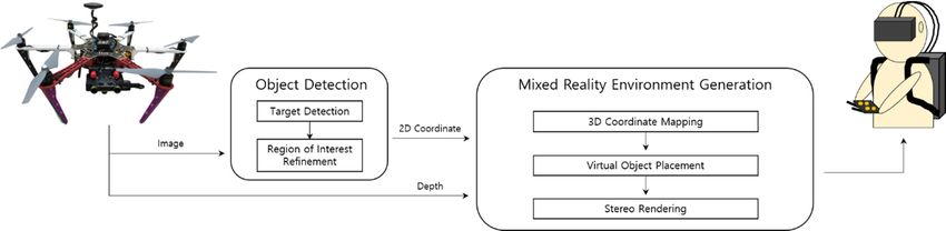
Appl. Sci. 2020, 10, 5436                                                                                                        7 of 17

Transfer learning refers to the use of a pre-trained model that was trained on a large benchmark dataset
for a new problem. Due to (a)           the computational cost of training, it is (b)      typical to use models from the
published literature (e.g., Visual Geometry Group, Inception, MobileNet). A comprehensive review
          Figure 4. (a,b) First-person-view of a drone in mixed reality combining a real world with a virtual
of pre-trained models’ performance using data from the ImageNet [45] challenge was presented by
          city.
Canziani et al. [46]. For transfer learning in this study, the Google Inception V2 module [47] was
used  asFlight
    3.3.  a backbone
                  in a Mixed network,     which is the most typically used CNN since the release of TensorFlow.
                                Reality Environment
Subsequently, a faster R-CNN model pre-trained on the COCO dataset [48] was used. The data of the
          To generate virtual objects dynamically using real objects, the locations of real objects must be
objects to be recognized were collected through images captured during the actual FPV drone flight.
    determined based on the images obtained from the stereo camera. In this study, predefined objects
Thewere
     parameters
           recognized  of theby model    were learning
                                 the transfer    adjustedofappropriately
                                                              a faster R-CNN, for this system using
                                                                                  as described           the captured
                                                                                                  in Section               images
                                                                                                                2.3. Transfer
as learning
    learning is a popular method in computer vision because it can build accurate models in a timesaving of
                data.    As   a result   of learning,   flags  were    identified  with  an  average    performance        time
300 manner
     ms and [44].
                an average
                      Transfer  accuracy
                                   learningofrefers
                                                97% from
                                                     to thereal-time
                                                             use of a video    frames.
                                                                        pre-trained      Here,
                                                                                     model      thewas
                                                                                             that   accuracy
                                                                                                         trainedwason calculated
                                                                                                                       a large
as abenchmark
     ratio of thedataset
                       number  for of  correctly
                                    a new          identified
                                            problem.            images
                                                       Due to the         to the total
                                                                     computational      number
                                                                                     cost          of test
                                                                                           of training,     images
                                                                                                         it is typicalwith
                                                                                                                        to useflags
acquired    from     an  experimental       flight lasting  around     1 min.
    models from the published literature (e.g., Visual Geometry Group, Inception, MobileNet). A
    comprehensive
      Virtual objectsreview           of pre-trained
                            can be created             models’
                                               interactively      performance
                                                               using              using data
                                                                        physical objects.       from the virtual
                                                                                            For example,     ImageNet large[45]
                                                                                                                              rings
canchallenge
     be generated  was next
                          presented
                                to droneby Canziani    et al.as[46].
                                             racing flags,       shownFor transfer
                                                                          in Figurelearning
                                                                                      5, which in can
                                                                                                  this be
                                                                                                        study,
                                                                                                           passedthe through
                                                                                                                      Google to
    Inception
practice   drone  V2flying.
                       module   As[47]  was used
                                     another        as a backbone
                                                example,   trees in network,    which
                                                                      a forest can      is the most using
                                                                                    be generated      typically   used
                                                                                                               water     CNN for
                                                                                                                      bottles
    since   the
    Appl. Sci.    release
               2020,         of
                     10, x FOR  TensorFlow.
                                PEER   REVIEW Subsequently, a faster R-CNN model pre-trained on the COCO
practicing obstacle dodging, as shown in Figure 6.                                                                       7 of 17
    dataset [48] was used. The data of the objects to be recognized were collected through images
    captured during the actual FPV drone flight. The parameters of the model were adjusted
    appropriately for this system using the captured images as learning data. As a result of learning, flags
    were identified with an average performance time of 300 ms and an average accuracy of 97% from
    real-time video frames. Here, the accuracy was calculated as a ratio of the number of correctly
    identified images to the total number of test images with flags acquired from an experimental flight
    lasting around 1 min.
         Virtual objects can be created interactively using physical objects. For example, virtual large
    rings can be generated next to drone racing flags, as shown in Figure 5, which can be passed through
    to practice drone flying. As   (a)another example, trees in a forest can be (b) generated using water bottles
    for practicing obstacle dodging, as shown in Figure 6.
         Figure
      Figure     4. (a,b)
             4. (a,b)     First-person-view
                       First-person-view  of of a drone
                                             a drone  in in mixed
                                                          mixed   reality
                                                                reality   combininga areal
                                                                        combining       realworld
                                                                                             worldwith
                                                                                                   witha avirtual
                                                                                                           virtualcity.
          city.

    3.3. Flight in a Mixed Reality Environment
          To generate virtual objects dynamically using real objects, the locations of real objects must be
    determined based on the images obtained from the stereo camera. In this study, predefined objects
    were recognized by the transfer learning of a faster R-CNN, as described in Section 2.3. Transfer
    learning is a popular method in computer vision because it can build accurate models in a timesaving
    manner [44]. Transfer learning refers to the use of a pre-trained model that was trained on a large
    benchmark dataset for a new problem. Due to the computational cost of training, it is typical to use
    models from the published               (a) literature (e.g., Visual Geometry Group,          (b) Inception, MobileNet). A
    Appl. Sci. 2020, 10, x FOR PEER REVIEW
    comprehensive          review
                              Figure  of      pre-trained   models’     performance    using     data   from    the ImageNet8 of  17
                                                                                                                                [45]
                           Figure    5. 5.(a)(a)AAdetected
                                                   detectedflag,
                                                            flag, (b)
                                                                  (b) A
                                                                      A created
                                                                         createdvirtual
                                                                                 virtualring
                                                                                          ringnext
                                                                                                nexttoto
                                                                                                       the flag.
                                                                                                         the  flag.
    challenge was presented by Canziani et al. [46]. For transfer learning in this study, the Google
    Inception V2 module [47] was used as a backbone network, which is the most typically used CNN
    since the release of TensorFlow. Subsequently, a faster R-CNN model pre-trained on the COCO
    dataset [48] was used. The data of the objects to be recognized were collected through images
    captured during the actual FPV drone flight. The parameters of the model were adjusted
    appropriately for this system using the captured images as learning data. As a result of learning, flags
    were identified with an average performance time of 300 ms and an average accuracy of 97% from
    real-time video frames. Here, the accuracy was calculated as a ratio of the number of correctly
    identified images to the total number of test images with flags acquired from an experimental flight
    lasting around 1 min.
          Virtual objects can be(a)           created interactively using physical objects.       (b) For example, virtual large
    rings can be generated next to drone racing flags, as shown in Figure 5, which can be passed through
                    Figure    6.
                              (a)(a) Identifiedwater
                                                   waterbottles,
                                                          bottles, (b)
                                                                   (b) Created
                                                                       Created virtual
    to practice Figure
                   drone          Identified
                          6. flying.    As another      example,     trees      forest trees
                                                                           in a virtual can   using
                                                                                         treesbe
                                                                                               using the water
                                                                                                       the
                                                                                                 generated  waterbottles.
                                                                                                               usingbottles.
                                                                                                                       water bottles
    for practicing obstacle dodging, as shown in Figure 6.
          Target objects such as flags or bottles are identified by a faster R-CNN, and then the center point
    is calculated using the start and end points of the 2D coordinates of objects identified in the 2D image.
    The ZED camera calculates the distance between a specific pixel and the camera using triangulation
    [49]. After obtaining the distance z between the center point of the identified object and the camera,
    it is mapped to a 3D virtual space. The 3D virtual space is first defined by the viewpoint vector of the
    camera. The viewpoint of the camera is the z-axis, the width is the x-axis, and the height is the y-axis.
An Aerial Mixed-Reality Environment for First-Person-View Drone Flying - MDPI
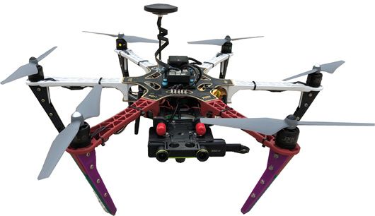
Appl. Sci. 2020, 10, 5436                                                                             8 of 17

      Target objects such as flags or bottles are identified by a faster R-CNN, and then the center point
is calculated using the start and end points of the 2D coordinates of objects identified in the 2D image.
The ZED camera calculates the distance between a specific pixel and the camera using triangulation [49].
After obtaining the distance z between the center point of the identified object and the camera, it is
mapped to a 3D virtual space. The 3D virtual space is first defined by the viewpoint vector of the
camera. The viewpoint of the camera is the z-axis, the width is the x-axis, and the height is the y-axis.
The locations of virtual objects are mapped in the Unity3D engine in the following manner.
      The center point calculated for 3D mapping must be adjusted according to the size of the screen to
be rendered to the user. The equation for the adjustment is as follows:

                                         (x0 , y0 ) = ((p(x, y))/h)                                      (1)

where (x, y) is the center of the detected object, p is the size of the rendered plane, and h is the size of
the image obtained from the camera. Furthermore, the Unity3D engine calculates the virtual world
coordinates by converting through a reverse projection from the current projection plane to the 3D
space using x’ and y’ from Equation (1) and the depth value z from the ZED camera. Finally, the virtual
objects are moved appropriately to the x- and y-axis directions such that the real and virtual objects do
not overlap on the 3D coordinates of the converted target object. In this case, the moving distance
is determined by the size of the virtual object to be generated. However, each task is performed
in the background because the performance speed can be unsatisfactory if the tasks are performed
separately for each of the multiple objects that appear on the screen. The 3D coordinates converted by
reverse projection are updated to V using Equation (2) when detection is completed. Here, V denotes
3D coordinates. The 3D coordinates x’, y’, and z in the current frame are returned to the corrected
coordinates F(V f ) after linear interpolation, as shown in Equation (2). Here, δ is the weight based on
the linear and angular velocities. In Equation (3), fps means frames per second and ω denotes the
angular velocity of the drone. In Equation (2), V f −1 is the 3D coordinates of the virtual object in the
previous frame, and V f is the 3D coordinates converted by reverse projection in the current frame.

                                       F(V f ) = (1 − δ)V f −1 + δV f                                    (2)

                                                     1
                                               δ=        ×ω                                              (3)
                                                    f ps
     One caution in creating an MR environment is that when virtual objects appear suddenly by
camera rotation, it can negatively affect the user’s sense of reality. To prevent this, virtual objects that
are generated are continuously tracked in the virtual world coordinates. This prevents the unnatural
mapping of virtual objects that appear again after disappearing from the screen and enables a stable
MR system because it is not significantly dependent on the object identification speed.
     The generated virtual obstacles can be designed as new shapes of obstacles in the flight
track planning stage of the drone; furthermore, the types of physical objects that determine the
locations of virtual objects can be selected freely. In addition, virtual obstacles can be added, moved,
or removed during drone flight. Hence, the user’s MR environment can be changed dynamically
by reflecting changes in the real environment. Figure 7a shows a drone racing track for generating
an MR environment; Figure 7b–d shows the view of the pilot flying in an MR environment created
using this system. Users can fly a drone in MR with a latency time of less than 20 ms when flying at
approximately 3–4 m/s.
     Finally, when the MR scene is rendered, the post-rendering of virtual objects in accordance with the
characteristics of the image obtained from a stereo camera must be performed. In the images acquired
from a stereo camera, motion blurs are generated depending on the drone movement or rotation;
however, they do not occur in virtual objects, which can provide a sense of difference. Therefore,
the parameters between the real and virtual cameras must be matched. In this system, the camera
parameters of Unity 3D were changed in accordance with the settings of the ZED mini camera to an
Appl. Sci. 2020, 10, 5436                                                                                                 9 of 17

aperture value of f/2.0, a focal length of 28 mm, a viewing angle of 110◦ , and an exposure value of
Appl. Sci. 2020, 10, x FOR PEER REVIEW                                                         9 of 17
50% of the camera frame rate. The focal length can vary by the camera resolution and calibration and
is significantly dependent on the camera resolution. In the ZED mini camera, the focal length was
removed during drone flight. Hence, the user’s MR environment can be changed dynamically by
1400 pixels, each pixel size was 0.002 mm, and the focal length was 28 mm. For system efficiency,
reflecting changes in the real environment. Figure 7a shows a drone racing track for generating an
the viewing angle was set to 110◦ . The exposure was set to 50% of the camera frame rate, and the
MR environment; Figure 7b–d shows the view of the pilot flying in an MR environment created using
degree of motion blur was determined in real time. Hence, the differences between images rendered
this system. Users can fly a drone in MR with a latency time of less than 20 ms when flying at
by the cameras of the real and virtual worlds were minimized by synchronizing the aperture value,
approximately 3–4 m/s.
focal length, viewing angle, and exposure value.

                                   (a)                                                      (b)

                                   (c)                                                      (d)
      Figure 7.
      Figure   7. (a–d)
                    (a–d)First-person view
                           First-person    (FPV)
                                        view     drone
                                              (FPV)    flight
                                                    drone     images
                                                           flight    in a time
                                                                  images   in a sequence withinwithin
                                                                                 time sequence an aerial
                                                                                                      anmixed-
                                                                                                         aerial
      reality (MR) environment.
      mixed-reality    (MR) environment.

4. Experimental
      Finally, when   Results
                         the MR scene is rendered, the post-rendering of virtual objects in accordance with
the characteristics of the image obtained from a stereo camera must be performed. In the images
4.1. Experimental Environment
acquired from a stereo camera, motion blurs are generated depending on the drone movement or
rotation;   however,
      To conduct     user they    do not
                             studies        occur
                                        of an FPVindrone
                                                       virtual   objects,
                                                              flight in MR,which    can provideana experimental
                                                                              we constructed            sense of difference.
                                                                                                                           drone
Therefore,
racing        the parameters
         environment               between
                           in a drone         the (8
                                         airfield   real
                                                      m and    virtual20cameras
                                                          in length,               mustand
                                                                         m in width,      be matched.      In thisas
                                                                                              5 m in height),       system,
                                                                                                                       shownthe in
camera8.parameters
Figure                    of Unityflags
            Three checkpoint         3D were    changed
                                           and one          in accordance
                                                      destination   were setwith    thedrone
                                                                               in the   settings   of path.
                                                                                               flight  the ZED     miniflying
                                                                                                               While     camera an
to androne,
FPV    aperture    value
                virtual  3Dofobstacles
                               f/2.0, a focal
                                          werelength
                                                 createdof at
                                                            28 each
                                                               mm, checkpoint
                                                                     a viewing angle      of 110°,
                                                                                   and mixed         andthe
                                                                                                  with     anvideo
                                                                                                               exposure
                                                                                                                      feedvalue
                                                                                                                             from
of 50%
the drone of the  camera
             camera.     Theframe
                               flightrate.
                                       timeThe    focal
                                             to the      length can
                                                      destination     vary
                                                                    was   setby
                                                                              to the  camera resolution
                                                                                  approximately       1 min to and   calibration
                                                                                                                  complete     the
and iswithin
flight   significantly
                 a short dependent
                           time. To adjuston the
                                               the camera     resolution.
                                                    difficulty,            In the ZED
                                                                 more checkpoints      canmini    camera,
                                                                                            be added          thedrone
                                                                                                          or the   focal can
                                                                                                                           length
                                                                                                                                be
was 1400
flown   in apixels,
              largereach
                      area.pixel
                              First,size wasstudy
                                      a user   0.002 mm,     and the focal
                                                       was conducted      to length   was 28
                                                                             investigate    themm.    For system
                                                                                                  differences         efficiency,
                                                                                                                 in immersion
thestereoscopic
by   viewing angle       wasand
                     sense      set presence,
                                    to 110°. The     exposure
                                                 in which         was set to FPV
                                                              an MR-based      50% of    the in
                                                                                     flight   camera     frame rate,
                                                                                                 a simulated      manner andwasthe
degree of motion
compared               blur was determined
              with a VR-based        FPV flight. in    real
                                                     The     time. Hence,
                                                           experiment       theofdifferences
                                                                         data                    between
                                                                                   the participants     wereimages     rendered
                                                                                                                collected    after
by the cameras
receiving    writtenof consent
                        the real and     virtual
                                    of each        worlds were
                                              participant          minimizedwith
                                                              in accordance       by synchronizing
                                                                                       the Declaration    theofaperture
                                                                                                                 Helsinki  value,
                                                                                                                              and
focalinstitutional
our    length, viewing       angle, and
                      regulations          exposure
                                      (Research         value.
                                                    ethics  and integrity committee, 20200662, Sejong University).
Furthermore, the participants received an explanation and video training from the researcher about
4. Experimental
each  environment,   Results
                          and were notified before the experiment about the system components of each
environment (viewing angle, monocular or binocular, resolution, etc.) A second user study was
4.1. Experimental
conducted             Environment
               to investigate     the differences in FPV flights from the control of drones in real-word, VR,
and MR     environments
      To conduct              by actual
                      user studies      of pilots.
                                           an FPV drone flight in MR, we constructed an experimental drone
racing environment in a drone airfield (8 m in length, 20 m in width, and 5 m in height), as shown in
Figure 8. Three checkpoint flags and one destination were set in the drone flight path. While flying
an FPV drone, virtual 3D obstacles were created at each checkpoint and mixed with the video feed
from the drone camera. The flight time to the destination was set to approximately 1 min to complete
the flight within a short time. To adjust the difficulty, more checkpoints can be added or the drone
Helsinki
Helsinki      and
            and ourour  institutional
                      institutional    regulations
                                    regulations     (Research
                                                 (Research     ethics
                                                             ethics andand integrity
                                                                         integrity      committee,
                                                                                     committee,     20200662,
                                                                                                 20200662,     Sejong
                                                                                                             Sejong
  University).     Furthermore,    the   participants  received   an  explanation     and  video
University). Furthermore, the participants received an explanation and video training from the    training  from    the
  researcherabout
researcher      abouteacheachenvironment,
                                environment,and andwere
                                                     werenotified
                                                            notifiedbefore
                                                                       beforethetheexperiment
                                                                                     experimentabout
                                                                                                  aboutthe
                                                                                                         thesystem
                                                                                                              system
  components       of each  environment    (viewing   angle, monocular    or  binocular,  resolution,
components of each environment (viewing angle, monocular or binocular, resolution, etc.) A second     etc.) A second
  user  study
user Sci.
Appl. study     was
          2020,was     conducted   to investigate  the differences   in FPV   flights  from the control
                    conducted to investigate the differences in FPV flights from the control of drones
               10, 5436                                                                                 of  drones 17 in
                                                                                                             10 of in
  real-word,
real-word,      VR,
              VR,     and
                    and  MRMR   environments
                              environments    byby actual
                                                 actual    pilots.
                                                         pilots.

                            Figure
                          Figure 8. 8.
                                    An An experimental drone racing environment
                                                                              in in a drone  airfield.
                          Figure 8. An experimental
                                        experimental drone
                                                     drone racing environment
                                                           racing environment in aa drone
                                                                                    drone airfield.
                                                                                          airfield.

  4.2.
4.2.   Immersion
     Immersion inin FPV
                  FPV   Flights
                      Flights

       ToTo
       To      evaluate
           evaluate
            evaluate     the  theusability
                                    usability
                              usability
                            the                ofof
                                           of the       theproposed
                                                    proposed
                                                     the       proposed
                                                                    MR-based   MR-based
                                                                                   FPV flight,
                                                                            MR-based         FPVFPVits flight,its
                                                                                                       flying
                                                                                                    flight,       itsflying
                                                                                                                        flyingexperience
                                                                                                                experience         experience
                                                                                                                                   was   comparedwaswas
   compared
with   that ofwith
compared           with
                  a drone   that   of
                         that flight  a  drone
                                        simulator.
                                of a drone         flight
                                                flightFor    simulator.       For
                                                               this comparison,
                                                          simulator.                this   comparison,
                                                                                         16 participants
                                                                           For this comparison,               16  participants
                                                                                                               (average age:(average
                                                                                                           16 participants             (average
                                                                                                                                       25.44 years; age:
                                                                                                                                                 age:
   25.44years;
range:
25.44       years;
          22–31        range:
                   years)
                    range:    wore22–31
                                22–31a VR   years)
                                            HMDwore
                                         years)        wore
                                                      and     a aVR
                                                             viewed VRHMD  HMD
                                                                        flying        andviewed
                                                                                  scenes
                                                                                   and       viewedflying
                                                                                            controlled   flying
                                                                                                           by an    scenescontrolled
                                                                                                                    experienced
                                                                                                                scenes           controlled      byanan
                                                                                                                                        dronebypilot
in experienced
   each environment.
experienced           drone
                   drone        pilot  in each
                                Theinexperience
                             pilot      each      environment.
                                                       of VR simulators
                                               environment.          TheThe    experience
                                                                                 is generally
                                                                            experience       ofof
                                                                                                VR VR   simulators
                                                                                                  evaluated
                                                                                                     simulators        is is
                                                                                                                by active    generally      evaluated
                                                                                                                                task completion.
                                                                                                                          generally      evaluated
   by
However,active
by active in       task
                task        completion.
                    thecompletion.
                          first user study,   However,
                                                 we compared
                                           However,              in  the
                                                             in the the     first   user
                                                                        firstcinematic
                                                                                 user study,study,     we
                                                                                              VR experiences compared
                                                                                                    we compared       in both  the    cinematic
                                                                                                                            the environments
                                                                                                                                   cinematic VR       VR
so experiences
experiences        ininboth
    that differences       both
                              wereenvironments
                                      not caused
                                environments         sosoby  that    differenceswere
                                                              thedifferences
                                                           that     operation          werenot
                                                                                     difficultynotcaused
                                                                                                     causedbyby
                                                                                                   between       athe  theoperation
                                                                                                                     real    operation
                                                                                                                             FPV     drone   difficulty
                                                                                                                                               and a
                                                                                                                                           difficulty
between a real FPV drone and a simulator. These experiences are passive, but the viewer is isstill
   between
simulator.       a
               Thesereal    FPV    drone
                          experiences       and
                                          are       a
                                               passive,simulator.
                                                             but   the  These
                                                                        viewer     experiences
                                                                                   is still engaging are   passive,
                                                                                                          in multiple    but    the
                                                                                                                            cognitive viewer         still
                                                                                                                                           activities.
Theengaging
      evaluation
engaging          in   multiple
                       techniques
              in multiple           cognitive      activities.
                                       for cinematic
                                  cognitive     activities. VR The  The    evaluation
                                                                  experiences
                                                                       evaluation           techniques
                                                                                   weretechniques
                                                                                           proposed by      for   cinematic
                                                                                                         forMacQuarrie
                                                                                                               cinematic VR        VR
                                                                                                                                  et al.  experiences
                                                                                                                                          [50] and a
                                                                                                                                       experiences
were proposed by MacQuarrie et al. [50] and a similar evaluation approach to ours was used inin
   were
similar    proposed
           evaluation      by   MacQuarrie
                             approach     to  ourset  al.
                                                      was  [50]
                                                             used andina  similar
                                                                         [51].        evaluation      approach        to  ours    was    used       [51].
                                                                                                                                                 [51].
          Figure
       Figure        9  shows    the  flying   scenes      of  each   environment
       Figure 9 shows the flying scenes of each environment and a participant              and  a  participant
                                                                                                participant in      in
                                                                                                                 in the the   indoor
                                                                                                                      the indoor         experiment.
                                                                                                                           indoor experiment.
                                                                                                                                       experiment.
TheThetop
      toptop   images
            images
            images       areare
                              thethe
                               the     viewpoint
                                    viewpoint
                                    viewpoint       of ofthe
                                                         thethe    drone
                                                               drone
                                                               drone        flying
                                                                        flying
                                                                         flying    inin
                                                                                   in      a virtual
                                                                                       aa virtual
                                                                                           virtual     environment,
                                                                                                    environment,
                                                                                                     environment,             which
                                                                                                                           which
                                                                                                                           which      waswas    created
                                                                                                                                             created
                                                                                                                                             created
   similarly
similarly    to tothethe   experimental
                        experimental          environment
                                           environment              shown
                                                                  shown     in in  Figure
                                                                                Figure        8 by
                                                                                           8 by     modifying
                                                                                                 modifying            a virtual
                                                                                                                  a virtual         space
                                                                                                                                 space       provided
                                                                                                                                           provided
   by  Microsoft        AirSim,     a popular      drone
by Microsoft AirSim, a popular drone flight simulator.        flightsimulator. The bottom images are the view of thethe
                                                                       simulator.       The   bottom     images       are   the   view     of       pilot
                                                                                                                                                pilot
                                                                                                                                                 pilot
   flying
flying
flying   in in our
             our   MR  MR    environment.
                          environment.
                          environment.        TheThe    flying
                                                     flying        scenes
                                                                scenes       from
                                                                          from       a stereo
                                                                                  a stereo       camera
                                                                                              camera        were
                                                                                                         were        recorded
                                                                                                                 recorded
                                                                                                                 recorded        forfor
                                                                                                                                 for      1 min
                                                                                                                                      11 min   in in
                                                                                                                                                   thethe
   same
same       experimental
        experimental             environment.
                              environment.         TheThe    drone
                                                           drone       pilot
                                                                     pilot
                                                   The drone pilot flew         flew
                                                                             flew    at at
                                                                                         a a  speed
                                                                                           speed       below
                                                                                                    below     4  4
                                                                                                                 m/s m/s to to
                                                                                                                             thethedestination in in
                                                                                                                                      destination
                                                                                                                                   destination
   each   environment
each environment
       environment without     without     hitting
                             without hitting
                                         hitting the  the   obstacles.
                                                   the obstacles.           In  both    environments,
                                                          obstacles. In both environments,
                                                                                     environments, a viewing a viewing
                                                                                                             viewing angle    angle
                                                                                                                           angle of  ofof
                                                                                                                                        110 110°
                                                                                                                                         110°◦ andanda a
   resolution
resolution     of of   2160
                    2160
                    2160    ×  × 1200
                            × 1200       were
                                      were       used.
                                             used.

          Figure 9. A participant viewing FPV flying scenes in virtual reality (VR) and MR environments.

      All participants were experienced in playing 3D video games using a VR HMD, and no participant
felt strong motion sickness during the experiment. The participants engaged in the experiment for up
to 20 min including the warm-up time, and they experienced drone flights at a stable speed below 4 m/s
because a higher drone speed could induce simulator sickness [41]. Subsequently, the participants
responded to the questionnaire shown in Table 1 such that the overall user immersion after experiencing
each environment could be measured. The simplified questionnaire for measuring immersion [39]
comprised 24 questions. The 18 questions for measuring immersion in the configuration of each
Appl. Sci. 2020, 10, 5436                                                                                11 of 17

environment could be answered based on a five-point agreement scale. They comprised four questions
regarding emotion, three regarding flow, three regarding immersion, three regarding judgment, and five
regarding presence. Furthermore, because the degree of simulator sickness [52] affects the user’s
immersion, six questions regarding the experience were posed to determine it. The replies to positive
questions were marked as “P” and negative ones as “N”. The reactions of each participant were analyzed
by calculating the scores of their replies to each question. In this questionnaire, scores on a five-point
Likert scale were calculated (strongly agree = 5, agree = 4, average = 3, disagree = 2, and strongly
disagree = 1). For negative questions, the scores were set in the opposite order. Significant results were
obtained from the negative and positive reactions. The response of all participants to each question
was calculated using the average score.

                            Table 1. The questionnaire for immersion and simulator sickness.

                                                                                        Scales           P/N
                                       Immersion
                        I enjoyed being in this environment.                           Emotion             P
    I was worried that the drone could crash due to collisions in flight.              Emotion             P
                           I liked the graphics and images.                            Emotion             P
                           I wanted to stop while doing it.                            Emotion             N
       When I mentioned the experience in the virtual environment, I
                                                                                         Flow              P
                experienced emotions that I would like to share.
      After completing the flight, the time passed faster than expected.                 Flow              P
  The sense of moving around inside the environment was compelling.                      Flow              P
                      I felt physically fit in the environment.                       Immersion            P
            I felt like I was boarding a drone in this environment.                   Immersion            P
                  I needed time to immerse myself in the flight.                      Immersion            N
            Personally, I would say this environment is confusing.                    Judgement            N
                     I felt that this environment was original.                       Judgement            P
                      I want to fly again in this environment.                        Judgement            P
      My interactions with the virtual environment appeared natural.                   Presence            P
                        I was able to examine objects closely.                         Presence            P
              I felt a sense of depth when the obstacles got closer.                   Presence            P
           I felt a sense of realness in the configured environment.                   Presence            P
       I thought that the inconsistency in this environment was high.                  Presence            N
                                  Simulator Sickness
   I suffered from fatigue during my interaction with this environment.         Experience consequence     N
 I suffered from headache during my interaction with this environment.          Experience consequence     N
 I suffered from eyestrain during my interaction with this environment.         Experience consequence     N
 I felt an increase in sweat during my interaction with this environment.       Experience consequence     N
   I suffered from nausea during my interaction with this environment.          Experience consequence     N
  I suffered from vertigo during my interaction with this environment.          Experience consequence     N

     Figure 10 shows the average score and standard deviation of immersion (including 18 questions
for measuring immersion and six questions for simulator sickness affecting the immersion) according to
the experience level of each environment. Both environments showed positive results for immersion,
with 3 points (average immersion) or higher. Furthermore, the flight in the MR environment showed
an overall immersion that was higher by approximately 0.41 than the flight in the VR environment.
We performed the two-sample t-test to determine if there was a statistically significant difference
between the means of two groups, since the data followed the normal distribution and the variances of
the two groups were equal. The resulting two-sided p-value was 0.011, therefore there was a significant
difference between VR and MR environments regarding user immersion at the 95% level (p < 0.05).
This suggests that the immersive experience elements added based on stereoscopic view and real
world obtained from a stereo camera contributed positively to the overall evaluation measure.
significant difference between the means of two groups, since the data followed the normal
distribution and the variances of the two groups were equal. The resulting two-sided p-value was
0.011, therefore there was a significant difference between VR and MR environments regarding user
immersion at the 95% level (p < 0.05). This suggests that the immersive experience elements added
based
Appl. Sci.on stereoscopic
           2020, 10, 5436 view and real world obtained from a stereo camera contributed positively
                                                                                               12 of to
                                                                                                     17
the overall evaluation measure.

                                             5

                                             4

                                             3

                                             2

                                             1
                                                        VR              MR

      Figure 10. The average score of immersion and standard deviation for experience in each
      Figure 10. The average score of immersion and standard deviation for experience in each environment.
      environment.
4.3. Actual Flight Experiences
       As a formative assessment, the second user study examined the effectiveness of the proposed
       As a formative
MR environment.          Toassessment,
                            investigate thethedifferences
                                                second user  in study     examined
                                                                FPV flights      whenthe     effectiveness
                                                                                         actual               of the the
                                                                                                  users controlled     proposed
                                                                                                                           drone
MR
in theenvironment.
         real word, and  To investigate
                             VR and MR    the  differences infour
                                             environments,       FPV drone
                                                                        flightspilots
                                                                                 when (average
                                                                                         actual usersage:controlled    the range:
                                                                                                            32.75 years;   drone
in the years)
25–36    real word,
                  wereand    VR andtoMR
                          recruited          environments,
                                         perform                four user
                                                      a qualitative     dronestudy.
                                                                                 pilots Two
                                                                                         (average     age: were
                                                                                                of these    32.75 expert
                                                                                                                   years; range:
                                                                                                                           pilots
25–36    years)   were    recruited   to  perform     a  qualitative    user   study.    Two
belonging to the FPV racing drone community, whereas the other two were experienced in FPV droneof  these  were    expert   pilots
belonging
flights.      to theskilled
          Experts     FPV racing     drone
                              in drone      community,
                                         control             whereasfor
                                                    were recruited       thethis
                                                                              other
                                                                                 usertwo   were
                                                                                        study     experienced
                                                                                                because            in FPV
                                                                                                           they were       drone
                                                                                                                        required
flights.  Experts   skilled   in drone   control    were  recruited    for  this user
to compare this MR system with the actual FPV drone system. Furthermore, they were     study    because    they   were  required
    compare this
to skillfully   playMR 3D system      with the
                            video drone     gamesactual   FPVa drone
                                                       using    VR HMD.   system.   Furthermore,
                                                                                Therefore,             theythat
                                                                                               the group     weresatisfied
                                                                                                                     required   to
                                                                                                                              this
skillfully play
condition           3D video
             was small.     In thedrone   games using
                                    experiment,             a VR HMD.
                                                     all participants          Therefore,
                                                                         did not   experience the simulator
                                                                                                   group that      satisfied this
                                                                                                                sickness.
condition
       Figurewas   small. In
               11 shows         the experiment,
                             a user  controlling aall    participants
                                                      drone   using the  did   not experience
                                                                            proposed     MR system simulator    sickness.
                                                                                                        and their    viewpoints.
       Figure 11
To compare      theshows    a userin
                    immersion        controlling
                                       controlling  a drone  using
                                                      the drone   in the
                                                                       eachproposed      MR system
                                                                              environment,              and theiraviewpoints.
                                                                                                we conducted          qualitative
To compare
user            the aimmersion
      study after                   in controlling
                       real FPV drone     flight, an the   drone in
                                                       MR-based     FPVeach   environment,
                                                                           drone   flight, andwe     conducted a of
                                                                                                 a manipulation       qualitative
                                                                                                                        a virtual
user   study   after   a  real  FPV   drone   flight,   an MR-based        FPV   drone    flight,  and
FPV drone in the virtual simulator AirSim by expert pilots. Figure 7 shows the images recorded during    a  manipulation     of a
virtual
this       FPV drone
      experiment.      Theinflight
                               the virtual   simulatorMR
                                    in the proposed        AirSim     by expert
                                                              environment        hadpilots.
                                                                                       a wider Figure   7 shows
                                                                                                  viewing    angle the
                                                                                                                     and images
                                                                                                                          higher
recorded    during     this  experiment.    The    flight in the  proposed      MR    environment
resolution than the real FPV drone flight. Furthermore, the camera mounted in the proposed MR           had   a  wider   viewing
angle and
drone    washigher
               a stereo resolution
                           camera, than
                                      whichtheprovided
                                                real FPVadrone
                                                             greater flight.  Furthermore,
                                                                         stereoscopic     sensethethancamera   mounted
                                                                                                         the images        in the
                                                                                                                        received
proposed
from          MR drone
        the drone   with awas mono a stereo
                                      camera.camera,
                                                 Finally,which      providedina the
                                                           the differences          greater    stereoscopic
                                                                                         generated     virtual sense    thanwere
                                                                                                                 obstacles     the
images    received    from   the  drone   with   a mono    camera.    Finally,   the  differences    in
compared with real obstacles. All of the participants were skilled drone pilots with experience playing the  generated    virtual
obstacles
3D           were compared
     video games     using a VRwith HMD. realHowever,
                                               obstacles.   Allofofthe
                                                          two        the   participants
                                                                        drone   pilots had  were
                                                                                               onlyskilled   dronemanipulated
                                                                                                     previously      pilots with
third-person-view drones and participated in the experiment after becoming familiar with FPV drone
flights through several practices. The drone experts performed flight in an MR environment after
completing flights in a real FPV drone and those in a VR environment. Tables 2 and 3 list the differences
between the environments.
     Compared with the real FPV drone flight, the positive differences of the proposed MR environment
are wide viewing angle, high resolution, strong sense of depth, and no adaptation time required.
The participants reported that the concentration of manipulation increased as the viewing angle
widened during flight. When flying a real FPV drone, they must become acquainted with the flight
path before starting a flight owing to the limited viewing angle because the current moving direction
cannot be determined easily based on the limited viewing angle. This is consistent with the research
results of Bowman et al. [53] and Lin et al. [54], i.e., when the viewing angle widens, the pilot can
concentrate on understanding the space because the distraction of spatial understanding and spatial
memory is reduced. Like real obstacles, all participants felt the presence of virtual objects created by
the MR system. However, they reported slight simulator sickness because virtual 3D objects were
generated, particularly when a crash with virtual objects occurred. The weak simulator sickness felt
You can also read