Call for Bids NS15-1 - Exploration history, geologic setting, and exploration potential: Western and Central regions
←
→
Page content transcription
If your browser does not render page correctly, please read the page content below
CNSOPB Geoscience Open File Report, 2015-001MF, 49 p.
Call for Bids NS15-1 – Exploration history, geologic setting, and exploration potential: Western and Central
regions
Mark E. Deptuck*, David E. Brown, and Brian Altheim
Canada-Nova Scotia Offshore Petroleum Board, Halifax, Nova Scotia, Canada
* mdeptuck@cnsopb.ns.ca
1. Overview
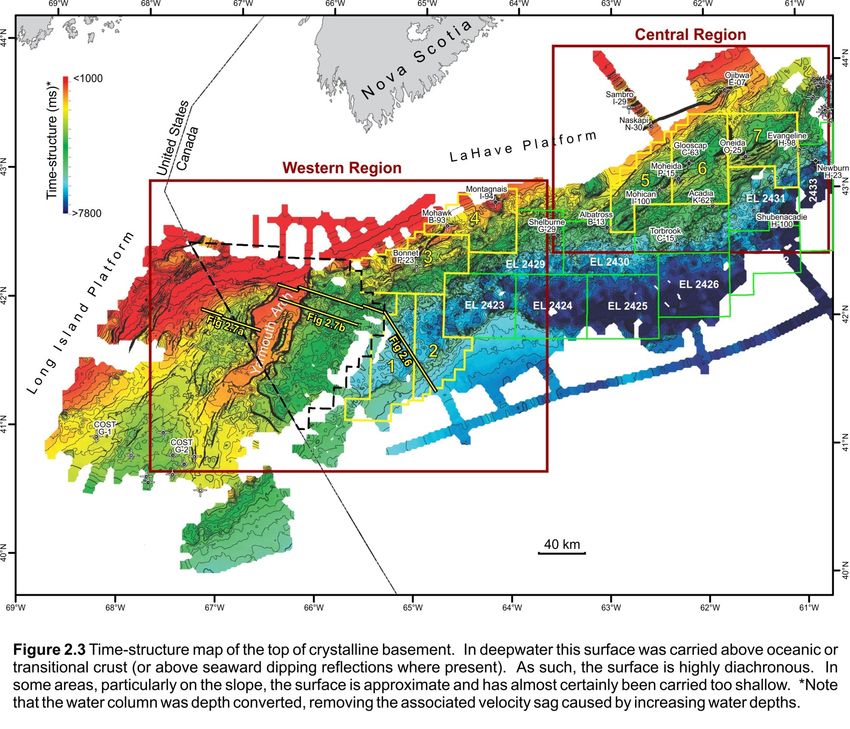
The NS15-1 Call for Bids includes nine parcels that are clustered into three geographically and geologically distinct areas
(Figure 1.1). Parcels 1, 2, 3, and 4 are located on the outer shelf and slope along the southwestern most parts of the
Scotian margin, adjacent to and seaward of Georges Bank (Western Region). Parcels 5, 6, and 7 are located on the outer
shelf and upper slope of the central Scotian margin, west of the Sable Island and the Sable Subbasin (Central Region).
Parcels 8 and 9 are located above existing oil and gas discoveries on the shelf in the Sable Subbasin, north and east of
Sable Island – these being the Penobscot oil discovery in fluvial-deltaic sandstones of the Missisauga Formation and the
Eagle discovery in chalks of the Wyandot Formation (Figure 1.2), respectively (Eastern Region). This document describes
the exploration history, geologic setting, and exploration potential for the Western and Central regions.
2. Western Region
U.S. side of Georges Bank, where ten wells were drilled
Exploration history on the shelf in the 1970’s and early 80’s (Figure 2.1).
The southwestern Scotian margin, stretching from
Georges Bank across the Northeast Channel, and to the Exploration started on the southwestern part of the
LaHave Bank (Figures 1.1, 2.1) is the most lightly margin in the late 1960s with the acquisition of regional
explored area of the Scotian Basin. Limited coverage of seismic and gravity-magnetic data on the Scotian Shelf /
modern seismic data-sets, especially on the shelf, LaHave Platform, followed by two wells in the early
coupled with very sparse well control, also makes this 1970s. Exploration along the Abenaki carbonate reef
one of the most poorly understood offshore regions of complex and along the upper Scotian Slope resulted in
Nova Scotia. Only four wells provide stratigraphic two additional wells in the 1980s. Large basin-scale
calibration in an area covering more than 28 000 km2. regional seismic programs were completed in the late
With Montagnais I-94 (Parcel 4) penetrating the central 1990s with emphasis on the deep water slope, and
uplift of an Eocene impact crater (see Deptuck and while the deep water slope was licensed by industry and
Campbell, 2012), only Mohawk B-93 (Parcel 4; drilled in some additional seismic acquired, no wells were drilled.
1970) and Bonnet P-23 (Parcel 3; drilled in 1984) Figure 2.2 shows the distribution of seismic data
provide calibration for Mesozoic strata on the acquired since 1970, and the location of wells.
southwestern Scotian Shelf. A fourth well, Shelburne G- The first well in the western region was Shell Mohawk
29 (drilled in 1985) provides the only stratigraphic B-93 (1970) and was also the fifth drilled in the Scotian
calibration of the southwestern Scotian Slope. It lies Basin. It is located in 117 m water and was designed to
along the easternmost edge of study area, more than 30 test a drape feature above a basement horst block
km east of Parcel 4, and provides little calibration of inboard of the basin hingeline fault (Figures 2.3, 2.4).
pre-Cretaceous strata. Additional calibration is Four-way simple closure was mapped at the top of the
available roughly 250 km southwest of Bonnet on the Late Jurassic Abenaki Formation and reservoirs were
1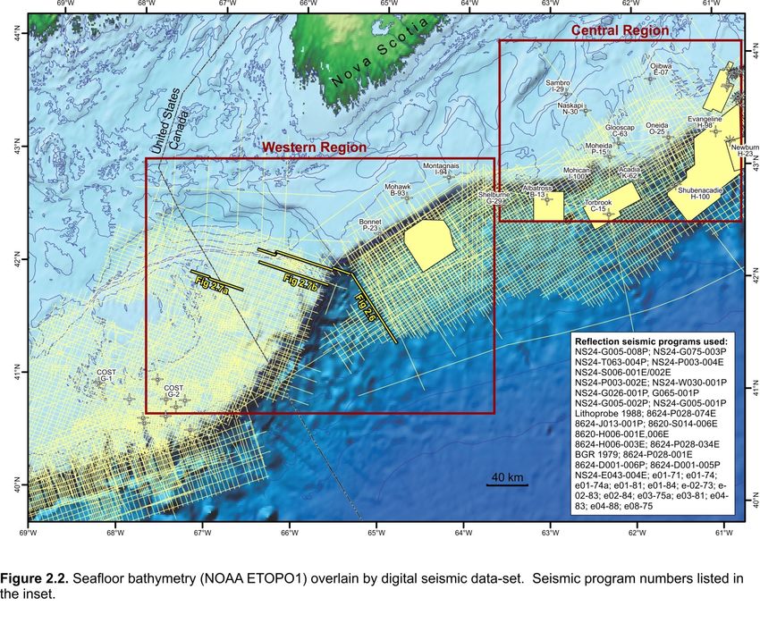
Deptuck et al. 2015
CNSOPB Geoscience Open File Report, 2015-001MF, 49 p.

3
Deptuck et al. 2015

expected within the Abenaki and underlying (then           mudstones. No reef-related facies were present. Rare
unnamed) fluvial siliciclastics. Some minor porosity was   porosity was found in the thick underlying Early Jurassic
present in Abenaki oolitic limestones though the           Iroquois Formation dolomites though the basal 450 m
dominant underlying coarse-grained fluvial sandstones      of this formation was not accurately evaluated due to
(Mohican Formation type section) had good to excellent     extensive lost circulation zones, incomplete mud-gas
porosity but no oil or gas shows. The well bottomed in     logging, lost mud and sample returns, etc. that may be
Middle Devonian granitic basement at a total depth of      the result of enhanced porous intervals or the presence
2124 m.                                                    of several large faults in this section. Four gas peaks
                                                           under 100 TGU were encountered here and minor oil
Another large basement feature was tested by the           staining in two samples but no tests done. Expected
Union Montagnais I-94 well in 1974 (Figures 2.3, 2.4).     coeval Mohawk or Mohican sandstones were not
2D seismic data defined a drape feature with presumed      present and the well TD was at 4336 m in the Iroquois
simple four-way closure on an isolated basement high
                                                           Formation.
at the edge of the basin hingeline fault. The high was
surrounded by a depression and a complexly faulted         The fourth well, Shelburne G-29 was drilled by Petro-
outer margin. The well was spudded in 113 m water          Canada in 1985 and is outside of the Call parcels, 30 km
depth and penetrated a thin clay-dominated Tertiary        east of Parcel 4. It was spudded in 1153.5 m water with
section followed by Early Cretaceous Logan Canyon          the primary target an interpreted turbidite fan of
Formation fluvial sandstones and shales. Well TD was at    Paleocene to possibly Maastrichtian age. The secondary
1644 m in highly deformed Cambro-Ordovician                target was an underlying southwest-plunging structural
metaquartzites of the Meguma Supergroup. Subsequent        nose of the Jurassic Abenaki carbonate margin (Middle
petrographic study of the basement core and the            Jurassic Scatarie Member) and dolomitic Iroquois
feature’s structural architecture revealed it was an       Formation above a salt pillow. A few minor sandstones
impact crater with an event age of ~50.5 Ma (Early         with scattered fair to very good porosity were
Eocene). A shallow minor gas show was found at 377.6-      encountered in the upper Tertiary. In the target interval
383.7 m in unconsolidated Quaternary gravels but was       (later confirmed to be the Late Cretaceous Wyandot
not tested.                                                and Dawson Canyon formations), the suspected
                                                           turbidite fan was found to be a succession of
The Petro-Canada Bonnet P-23 well (1984) is the            limestones, marls and shales, with the remaining
westernmost well in the Scotian Basin. It was drilled to   interval being almost entirely shale. The well just tagged
test a large (~70 km2), elongate, fault-bounded            the top of the Abenaki Formation (Baccaro Member)
structure located about 6 km inboard of the highly         and a core was attempted. However, after cutting 14.5
faulted bank margin in 133.5 m water. Closure was          m of core the drill string became stuck while pulling out
mapped at the interpreted Late Jurassic Mohawk             of the hole and following unsuccessful attempts to
seismic horizon, with its fluvial sandstones the primary   retrieve it the well was abandoned at a TD of 4005.5 m.
reservoir target. About 1700 m of Tertiary mudstones       No reservoirs or hydrocarbon shows were present.
are above several base Tertiary unconformities that cut
down through the Cretaceous section leaving a thin         Geological Setting
(~25 m) interval of Late Cretaceous sandstones and         Parcels 1, 2, 3, and 4 in the NS15-1 Call for Bids are
shales. This was followed by the entire Middle to Late     located on the outer shelf and slope of the
Jurassic Abenaki Formation (Roseway-Baccaro-Misaine-       southwestern most Scotian margin, east of the Georges
Scatarie members; Figure 1.2). The carbonates are          Bank moratorium area and existing (but inactive) BP and
dominately oolitic limestones and minor dolomites          Chevron exploration permits, and west of Shell’s
having occasional fair (inter-oolitic), to very good       Exploration Licences 2423 and 2429 (Figures 1.1, 2.1).
(intercrystalline dolomitic) porosity in lagoonal facies   The parcels sit above the westernmost parts of the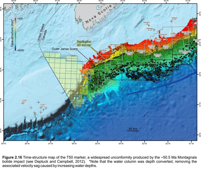
CNSOPB Geoscience Open File Report, 2015-001MF, 49 p.

5
Deptuck et al. 2015
CNSOPB Geoscience Open File Report, 2015-001MF, 49 p.

7
Deptuck et al. 2015
CNSOPB Geoscience Open File Report, 2015-001MF, 49 p.

9
Deptuck et al. 2015
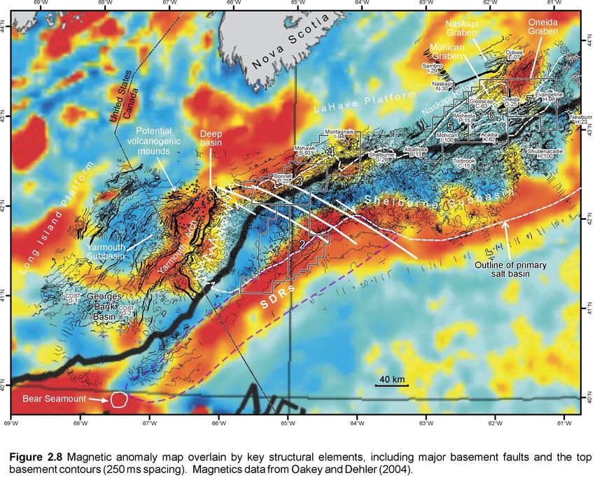
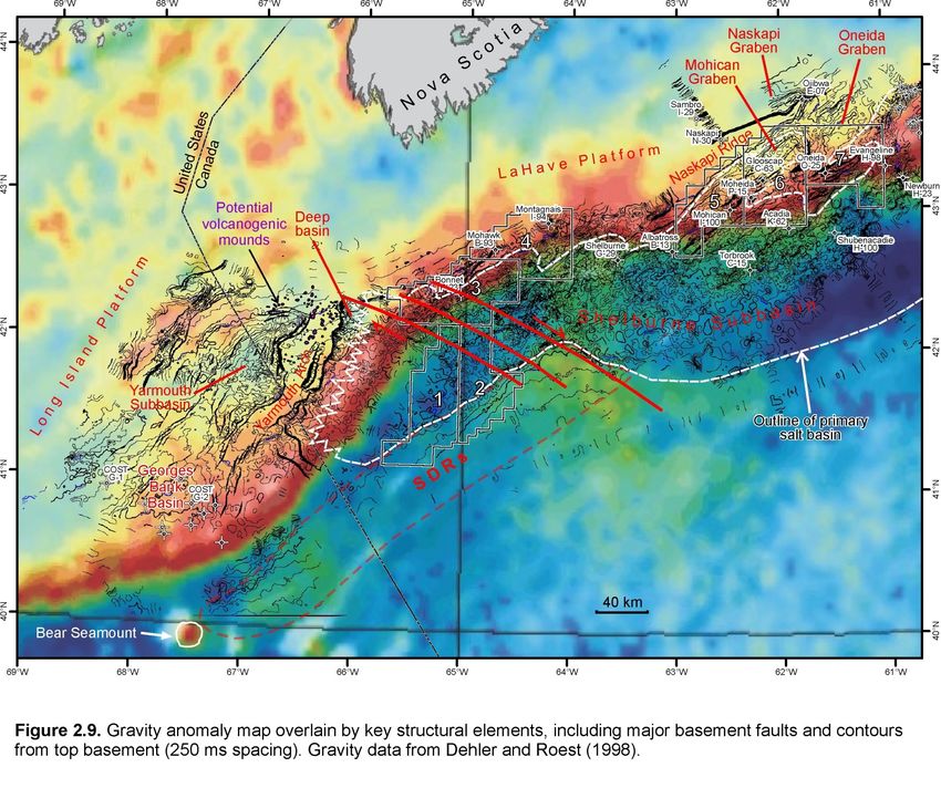
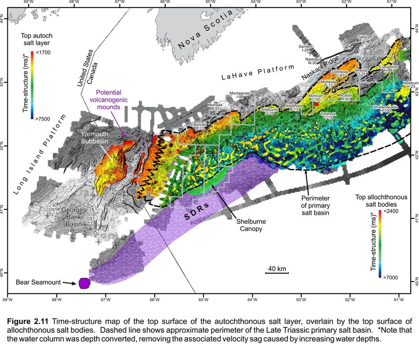
Shelburne Subbasin, as defined by Wade and MacLean On aeromagnetic data, the arch produces a strong
(1990), east of Georges Bank Basin (Figure 2.5). While positive magnetic anomaly that closely mimics its
numerous published reports are available for the planform shape (Figure 2.8). On gravity data it does not
geology of Georges Bank (e.g. Austin et al. 1980; Schlee produce an obvious anomaly, but is flanked to the west
and Klitgord 1988; Wade and MacLean 1990; Poag by a gravity low generated by the Yarmouth Subbasin
1991; Poppe and Poag 1993), modern research east of (described in a following section) and to the northeast
Georges Bank has been comparatively meager. Using a by another gravity low generated by a deep basin where
combination of vintage and more recent 2D and 3D the Yarmouth Arch intersects the LaHave Platform
reflection seismic data-sets (see Figure 2.2 for data- (Figure 2.9). A prominent positive shelf edge anomaly
coverage and a list of seismic programs used), the (gravity high) lies to its east along much of its length.
following discussion provides geological context for On reflection seismic profiles, the northern parts of the
Parcels 1 to 4 and detailed description of several Yarmouth Arch are veneered by a distinctive high
important structural and stratigraphic elements on this amplitude seismic reflection that continues beyond the
part of the margin. edges of the arch, above more heavily deformed strata
(Figures 2.7, 2.8). This surface passes laterally into an
Yarmouth Arch angular unconformity (collectively referred to as the
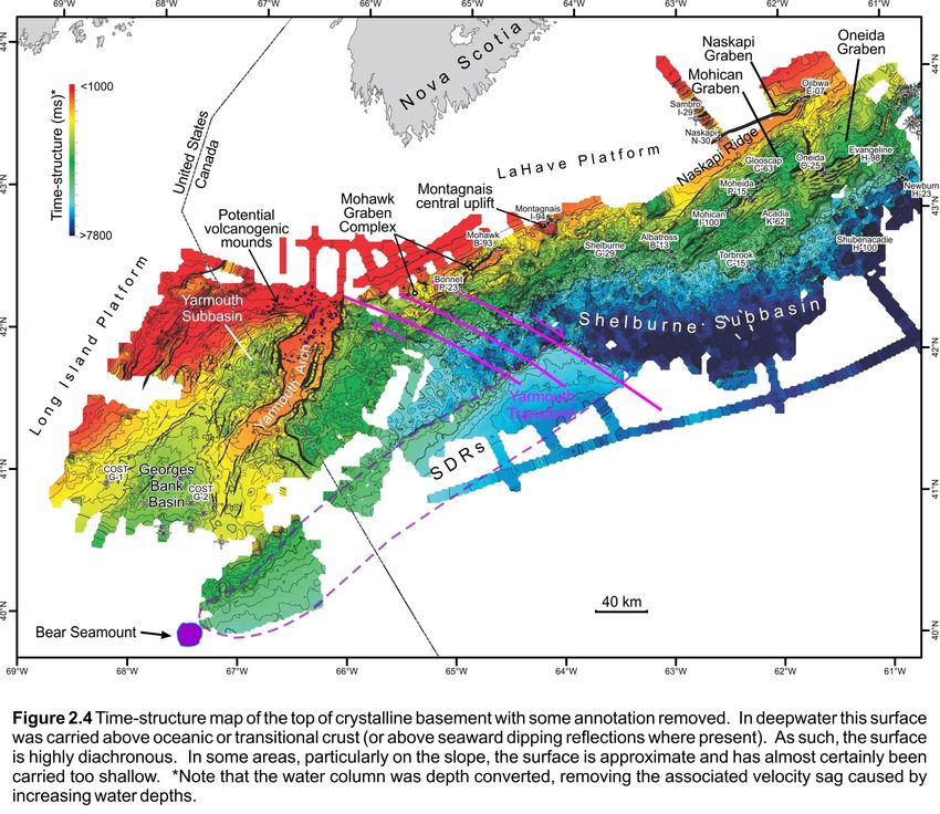
The Yarmouth Arch is the most prominent basement J200 marker, and shown in Figure 2.6). Its reflection
element off southwestern Nova Scotia (Figures 2.3, 2.4, seismic response is similar to that produced by the ~150
2.6). It consists of a faulted and segmented basement m thick CAMP-related lava flows penetrated by the
horst block that separates the Georges Bank Basin to its Glooscap C-63 well on the central Scotian Shelf and the
west from the Shelburne Subbasin to its east. The arch subsurface reflection produced by buried Rhaetian age
forms a SSW-trending protrusion of crystalline North Mountain Formation tholeiitic basalts in the
basement that extends at least 150 km from the
Fundy Basin. Contiguous with this reflection are a series
adjoining LaHave Platform. The 12 to 38 km wide top of positive relief mounds clustered around the northern
surface of the Yarmouth Arch is generally flat lying, parts of the arch (Figures 2.4, 2.6, 2.7, 2.10). Their
except where it is offset by normal basement faults or dimensions (< 70 to 210 ms (twt) tall and up to 4.1 km
where small volcanogenic features generate local wide, at the base) and appearance are strikingly similar
rugosity (described below; Figures 2.6, 2.7). The to Eocene volcanogenic mounds described by Magee et
structure generally narrows, is more deeply buried, and al. (2013) from high quality reflection seismic profiles
has a lower relief towards the SSW where it is more off southern Australia. The mounded features on the
difficult to map. The Yarmouth Arch is probably Yarmouth Arch are likewise interpreted as small
composed of Early Paleozoic metasedimentary rocks of volcanoes or volcanic vents. Indeed, Figure 2.6 reveals
the Meguma Supergroup and associated Devonian
a 900 m wide depression at the centre of the mound
granites that intrude them, but the basement rocks interpreted as a central vent, and like the volcanogenic
here have not been directly sampled. Early Paleozoic mounds described by Magee et al (2013), saucer shaped
metasedimentary crystalline basement is confirmed on reflections interpreted as subvolcanic sills are present
the Long Island Platform at the base of the Cost G-1 beneath some mounds, producing internal reflections
well, 90 km southwest of the Yarmouth Arch (Figure within the rocks of the Yarmouth Arch. This implies that
2.4). On the LaHave Platform, the Meguma the mounds did not simply grow above the Yarmouth
metasedimentary rock and granites have been sampled Arch, as might be expected if these features were
and dated from the base of the Montagnais I-94 and carbonate build-ups.
Mohawk B-93 wells located 120 and 175 km northeast
of the Yarmouth Arch, respectively (Wade and MacLean The strong magnetic character of the Yarmouth Arch
1990; Pe-Piper and Jansa 1999). (Figure 2.8) combined with its reflection seismic
character and the presence of interpreted volcanogenicCNSOPB Geoscience Open File Report, 2015-001MF, 49 p.
features, strongly implies that parts of the Yarmouth deformed layered successions, which could indicate
Arch are veneered by volcanic lava flows. Furthermore, that the primary salt was originally interbedded with
the flows appear to extend several kilometers west and other lithologies. Early fill above the salt is generally
east of the arch where they overlie deformed pre- layered. An impressive turtle structure occupies much
volcanic synrift stratigraphic successions or merge with of the basin, with most of the salt expelled towards the
the postrift unconformity. The lava flows and other Yarmouth Arch (Figure 2.7). A grid of the top salt
volcanogenic features are tentatively interpreted to be surface shows the distribution of isolated north to
related to the ~200 Ma CAMP episode. However, the northeast trending diapirs, as well as more complex salt
presence of buried Middle Jurassic seamounts at the structures that rose up along eastern border faults,
mouth of the Georges Bank Basin (Wade and MacLean, adjacent to the Yarmouth Arch (Figure 2.11). In
1990), and alkalic mid-Jurassic volcanics and ash flows addition to turtle structures, layered successions
encountered in two Georges Bank wells (Lydonia elsewhere above the salt are also commonly folded, and
Canyon 133 and Cost G-2; Hurtubise et al. 1987; Elliott an angular unconformity is present where these
and Post, 2012), raises the possibility that these deformed intervals were truncated by the postrift
volcanogenic features could be somewhat younger. unconformity just west of the Yarmouth Arch.
Unfortunately the Lower and Middle Jurassic succession
is highly condensed or absent above the northern parts The fill of the Yarmouth Subbasin has not been
of the Yarmouth Arch, making it impossible to penetrated by any wells, but correlation into Cost G-2
discriminate the timing of these features without direct ~50 km to the south indicates that much of the early
basin fill is older than the Early Jurassic(?) Argo Salt
sampling.
encountered at the base of this well (Schlee and
Primary salt basin west of Yarmouth Arch Klitgord 1988; Poppe and Poag 1993). Some workers
West of the Yarmouth Arch in the northeastern parts of have speculated the fill of the Yarmouth Subbasin could
the Georges Bank Basin is a distinct subbasin containing be as old as Carboniferous, with salt corresponding to
up to 2 sec (twt) of moderately to heavily deformed the basal Mississippian Windsor Group (e.g. Wade and
strata referred to here as the Yarmouth Subbasin MacLean 1990). However, it is equally possible the
(Figures 2.4, 2.5). Its general structure is a complexly basin formed in the Permian or even in the Triassic, with
faulted half-graben, with the most important border the salt here being equivalent to or slightly older than
faults dipping towards the west or northwest away from the Late Triassic Osprey Formation encountered in wells
the irregular western margin of the arch (Figure 2.7). on the southern Grand Banks (McAlpine 1990).
The subbasin is up to 52 km wide and 115 km long, with Although the maximum age of the salt in the Yarmouth
the thickest strata located above the hanging wall Subbasin cannot be known with the available data, it is
adjacent to the Yarmouth Arch or near the centre of the clear that some of the early salt structures were later
subbasin. Strata thin more gradually towards the west reactivated, and continued to influence sedimentation
and northwest, away from the arch, onto the faulted even after the postrift unconformity. Numerous faults
eastern parts of the Long Island Platform (sensu Wade sole out above or along the flanks of salt diapirs,
and MacLean 1990). offsetting Jurassic and even Lower Cretaceous strata,
and at least one growth interval involving probable
The basin fill is complex, consisting of faulted and folded Jurassic strata produced a distinct 40 km long and < 5km
layered successions as well as deformed transparent to wide north to northeast trending trough shaped salt-
chaotic intervals interpreted as salt bodies. The latter
withdrawal basin in the northern parts of the Yarmouth
are generally rooted to an autochthonous layer located Subbasin (Figure 2.10). As such, postrift salt tectonics in
above faulted basement, and range from pillows or salt this basin, as with the basins east of the Yarmouth Arch,
anticlines to poorly developed salt stocks or walls.
is prevalent. To the east however salt tectonism is
Some chaotic salt intervals pass laterally into folded and
11Deptuck et al. 2015
CNSOPB Geoscience Open File Report, 2015-001MF, 49 p.

13
Deptuck et al. 2015
more clearly linked to Late Triassic (Osprey) or earliest (Deptuck 2011a) (Figure 2.6). This step appears to have
Jurassic (Argo) salt (e.g. Shimeld 2004; Deptuck 2010, formed where seaward dipping reflections (SDRs),
2011a; Kendell 2012). presumed to correspond to thick intervals of basaltic
lava flows interlayered with volcaniclastics,
Primary salt basin east of Yarmouth Arch accumulated during the latest stages of rifting or
Another primary salt basin lies east of the Yarmouth earliest postrift (Larsen et al. 1994; Keen and Potter
Arch (Figure 2.11), occupying the western most parts of 1995; Jackson et al. 2000). In this setting, the volcanics
the Shelburne Subbasin, as defined by Wade and
loaded and depressed the seaward edge of the original
MacLean (1990). The salt basin corresponds, in part, to primary salt basin that separated Nova Scotia from
Shimeld’s (2004) salt province I. Crystalline basement, Morocco (Deptuck 2011a). As such, the volcanic
and the sediments that immediately overlie it, are wedges may bury parts of the salt basin and underlying
poorly imaged in this region. This is particularly true continental crust. SDRs have been tracked on seismic
along a 10 to 20 km band paralleling the Yarmouth Arch, profiles from the Bear Seamount, near the southern tip
where strata show subtle discontinuous layering, with of the Yarmouth Arch, to an interpreted transform fault
poorly defined faults and folds that cause the zone that offsets the seaward edge of the salt basin,
succession to pinch and swell (Figures 2.6, 2.7). The roughly 360 km to the northeast (i.e. the Yarmouth
succession, which is capped by the J200 marker, is
Transform – described below).
interpreted to correspond to Triassic rift deposits, and
the undulations to poorly developed salt pillows. Yarmouth Transform
Further down the slope there are clear salt pillows, Several observations infer that an important NW-SE
large salt rollers, and even rare salt diapirs, where trending strike-slip margin trends obliquely through the
younger faults increasingly sole out into this salt- southwestern Scotian margin (Figures 2.4, 2.8, 2.11):
bearing interval. Continuing down the slope, evidence
for salt rising from a thick primary salt basin is A greater than 60 km right-lateral offset of the
unequivocal, with widespread diapirism and minibasin Yarmouth Arch relative to the edge (hinge) of the
development (see Shimeld 2004; Deptuck 2011a). LaHave Platform immediately to its east;
a corresponding sharp, more than 60 km right-
These observations imply there is a lateral change in the lateral offset in the seaward limit of the
dominant lithofacies with increasing distance from the autochthonous salt basin;
Yarmouth Arch. Immature clastic-dominated Eurydice the presence of an anomalously deep salt basin
facies may pass laterally into mixed Eurydice and salt where the Yarmouth Arch intersects the LaHave
facies, and eventually into more massive salt intervals Platform;
(Osprey to Argo equivalent) towards the main part of clustering of volcanoes or volcanic vents along
the autochthonous salt basin (landward parts of Parcels the northern parts of the Yarmouth Arch
1 and 2; Figure 2.11), where rift and early postrift the abrupt change in the density, style, and
subsidence were greatest. Similar lithofacies changes distribution of salt bodies between Shimeld’s
are recognized in the Mohican Graben on the central (2004) salt provinces I and II; and
Scotian margin (described in a following section). The the recognition of clear offsets in the East Coast
western boundary of the primary salt basin is therefore Magnetic Anomaly (ECMA) that align with the
interpreted to be transitional over a 10 to 20 km region offset along the seaward boundary of the primary
adjacent to the Yarmouth Arch (Figure 2.11). salt basin.
In contrast, the seaward termination of the salt basin is The matching 60+ km right-lateral offsets in the
a clear linear structural boundary marked on seismic landward versus seaward boundaries of the salt basin,
profiles by an abrupt northeast-trending vertical step in particular, implies that either a single heavily curved
that forces inflated autochthonous salt to rise verticallyCNSOPB Geoscience Open File Report, 2015-001MF, 49 p.
strike-slip boundary, or a series of smaller scale slightly extensional growth faulting took place. One salt diapir
curved strike-slip faults, accommodated the offset in in this proximal region rises nearly to the seafloor (just
the salt basin. A similar transfer fault has been out of the plane of the seismic section). A profile
schematically proposed by both Manspeizer (1988) and further to the southwest shows a series of tightly
Welsink et al. (1989), but the basis for this fault is not spaced faults that sole out along a salt weld and within
discussed in any detail. The distribution of several en- the landward parts of the primary salt basin (Figure 2.7).
echelon deep-seated faults identified on seismic profiles Salt expulsion from this region appears to have driven
across this region implies that a wider region of strike- by gravity spreading in an area of increased
slip faulting accommodated the offset, rather than a sedimentation associated with the Shelburne Delta
single fault. Some of these faults sole out along and in (Wade and MacLean 1990). This delta system was long
some cases even offset the Moho. As such, this wider lived with numerous transgressive-regressive cycles
region of strike-slip faulting is similar to the situation recorded in Middle Jurassic to Upper Cretaceous strata,
along the southern Grand Banks (the southwest Grand across these growth faults. The clearest progradation,
Banks transform margin described by Pe-Piper and Piper however, appears to be within Cretaceous strata above
2004). the J150 marker (region identified in Figures 2.13, 2.14).
We herein refer to this strike-slip accommodation zone The density of salt diapirs increases down the slope.
as the Yarmouth Transform Fault Zone (or the Yarmouth Downbuilding above the main part of the
Transform for short), and similar to Manspeizer (1988) autochthonous salt basin appears to have produced a
and Welsink et al (1989) interpret it as a splay coming series of minibasins separated by complexly deformed
off the South Atlas fault zone (see figure 3.1 of salt diapirs. Isolated salt stocks and more elongated salt
Manspeizer 1988 and figure 20 of Welsink et al. 1989). walls are generally rooted to the primary salt layer
Right-lateral offset across the curved Yarmouth (Shimeld, 2004). Many of these salt bodies were
Transform helps explain the more northerly-trending reactivated and squeezed well into the Cenozoic, and
basement grain to its west (including the Yarmouth salt overhangs and pinched stems are common (Figure
Arch), compared to the dominantly northeast basement 2.6). Seaward of the salt basin is a 10 to 25 km wide
fabric to its east. A small amount of clockwise rotation and ~85 km long salt tongue canopy referred to as the
south of the transform re-aligns the basement fabric on Shelburne Canopy (Deptuck, 2011a). It was expelled up
both sides of the transform (Figure 2.5). and over the SDRs, advancing most rapidly across the
paleo-seafloor in the Middle to Upper Jurassic (right
Postrift Salt Tectonics side of Figure 2.6). It ceased its seaward advance at the
Postrift cover strata west of the Yarmouth Transform end of the Jurassic, and today sits immediately above
form a thin-skinned linked system above the primary the ECMA (Figure 2.11). Its timing is similar to the
salt basin, characterized by a landward extensional Banquereau Synkinematic Wedge on the eastern
domain and a seaward compressional domain (Figure
Scotian Slope (Deptuck et al. 2014).
2.6). A time-structure map along the top Jurassic
seismic marker (J150) shows the location of thin- Unlike the gravity spreading system to the west (where
skinned extensional faults in the landward part of this sedimentation rates were high), salt tectonics east of
system (Figures 2.12, 2.13). They extend in an arc that the Yarmouth Transform were driven primarily by
parallels the Yarmouth Arch continuing into the western gravity gliding in response to margin tilting, and not
parts of the Mohawk Graben Complex. Salt rollers sediment loading (Deptuck 2010, 2011a). The landward
dominate this region, but locally salt diapirs are also parts of the salt basin here are dominated by slabs of
present. The profile in Figure 2.6 crosses a more salt- Jurassic and to a lesser extend Cretaceous cover strata
rich region immediately adjacent to the northern part of that detached and slid down the slope above salt
the Yarmouth Arch where clear downbuilding and pillows and salt rollers, or a primary salt weld. This
15Deptuck et al. 2015
CNSOPB Geoscience Open File Report, 2015-001MF, 49 p.

17
Deptuck et al. 2015
CNSOPB Geoscience Open File Report, 2015-001MF, 49 p.

19
Deptuck et al. 2015

produced the ‘slope detachment province’ (Deptuck          grabens form narrow but deep (up to 1.4 sec twt) basins
2011a), which continues along the slope east of the        presumed to contain synrift fluvial-lacustrine strata
Yarmouth Transform for approximately 350 km. Taller        equivalent to the Eurydice Formation, capped by the
salt stocks and walls are generally restricted to the      J200 surface. The western parts of the Mohican Graben
slope seaward of this region, where downbuilding           Complex may also contain salt (western half of Parcel
within subcircular to elongated minibasins expelled salt   3), but detailed mapping is not possible here. Above
from the thickest parts of the primary salt basin. A       the Mohawk Graben Complex, the Middle to Late
detailed account of the salt tectonics east of the         Jurassic and earliest Cretaceous succession is
Yarmouth Transform is presented in Deptuck (2011a).        characterized by mixed carbonates and clastics that
                                                           were deposited above the Mohawk Graben Complex.
Parcel Description and Exploration Potential               Bonnet P-23 is the only test of the Middle to Upper
Parcels 1 and 2 are located entirely on the slope in       Jurassic carbonate bank west of Albatross, more than
water depths ranging from approximately 1050 to 3100       150 km away. It was drilled about 6 km back from the
m and above the primary salt basin that lies seaward of    highly faulted reef margin and encountered a variety of
the Yarmouth Arch. The Shelburne Delta is located          lithologies in the Baccaro: shaly limestones, dolomites
immediately landward (northwest) of these parcels.         and dolomitic limestones. Near the base of the Baccaro
Numerous complex salt diapirs and walls, expelled in       a number of thick dolomite intervals were penetrated
the Jurassic to mid-Cenozoic, can be found in the          with good porosities and loss circulation zones, but no
landward parts of Parcels 1 and 2. In contrast, the        hydrocarbons were encountered, possibly due to lack of
Middle to Late Jurassic Shelburne Canopy occupies the      fault seal. The northern edge of the Barrington 3D
seaward parts of these parcels (Figure 2.6). No wells      survey extends onto the outer parts of the carbonate
have been drilled in either parcel, but numerous           bank (Figure 2.12), where local carbonate build-ups are
hydrocarbon trap configurations are possible. Traps
                                                           recognized in the eastern part of Parcel 3. One of these
may include salt-cored folds, three-way closures on salt   has very bright amplitudes which could signal porosity
flanks, and traps associated with turbidite sands          development, hydrocarbon charge, or both. Other
beneath, and sealed by, the Shelburne Canopy as it         portions of the bank edge show rim development, but
advanced seaward. Turbidite sands derived from the
                                                           the lack of 3D seismic makes these difficult to map.
Shelburne Delta are the most likely reservoirs.
Tentative correlation into Cost G-2 and Mohawk B-93        In addition to carbonates, Middle to Upper Jurassic
implies that progradation of the Shelburne Delta began     siliciclastic reservoirs are also possible in these parcels.
in the Middle Jurassic (above the J163 marker), with       Mohawk B-93 encountered a 505 m thick texturally
numerous regressive-transgressive cycles recognized up     mature sand-dominated Upper Jurassic succession, of
into strata as young as Late Cretaceous. The best          which 194 m were porous sands averaging 23% porosity
developed delta clinoforms are found in Cretaceous         (Given, 1977).       Although it is not possible with the
strata above the J150 marker (Figure 2.14), particularly   existing dataset to delimit any traps in the landward
beneath the northeastern parts of Georges Bank (Figure     parts of Parcels 3 and 4, acquisition of modern 3D
2.13). As such, the most reservoir prone intervals in      seismic volumes may reveal new closures associated
Parcels 1 and 2, immediately downslope of the              with compaction above basement horst blocks or even
Shelburne Delta, are probably Cretaceous.                  fault blocks within the synrift succession, in addition to
                                                           potential carbonate-related targets.
Further north, Parcels 3 and 4 are located on the outer
shelf and upper slope in water depths ranging from         Significant portions of Parcels 3 and 4 are located
approximately 100 to 1700 m. The landward parts of         seaward of the margin hinge zone (and carbonate bank
these parcels are positioned above the Mohawk Graben       edge) and within the ‘slope detachment province’
Complex, in an area with poor seismic coverage. The
CNSOPB Geoscience Open File Report, 2015-001MF, 49 p. 21
Deptuck et al. 2015
CNSOPB Geoscience Open File Report, 2015-001MF, 49 p.

23
Deptuck et al. 2015
CNSOPB Geoscience Open File Report, 2015-001MF, 49 p.
described by Deptuck (2011a) (Figures 2.12, 2.13). Jansa Scarp’ of Deptuck and Campbell, 2012), partly
Seismic profiles indicate that the texturally mature overlapping Shell’s exploration licenses 2423 and 2429.
sand-dominated Upper Jurassic succession at Mohawk Two main intervals produce anomalous amplitudes that
B-93 correlates seaward into the topsets of a Callovian terminate up-slope and down-slope. Amplitude
or Oxfordian shelf-edge delta (forced regression - Figure extractions from the lower interval show a clear
2.15) in what must have been a gap in the carbonate network of channels converging down-slope into trunk
bank. The eastern parts of the Shelburne Delta may channels. The associated amplitude anomaly covers an
also have extended onto Parcels 3 and 4. Widespread area of about 290 km2 and terminates where it onlaps
erosion of Cretaceous shelf strata during the the steep foreslope of the Jurassic carbonate bank
Montagnais marine impact event, however, has (Figures 2.21, 2.22a). Amplitude extractions from the
removed the outer shelf succession east of the most upper interval show a much broader anomaly that
obvious Cretaceous Shelburne Delta clinoforms (e.g. appears to correspond to the floor of very wide latest
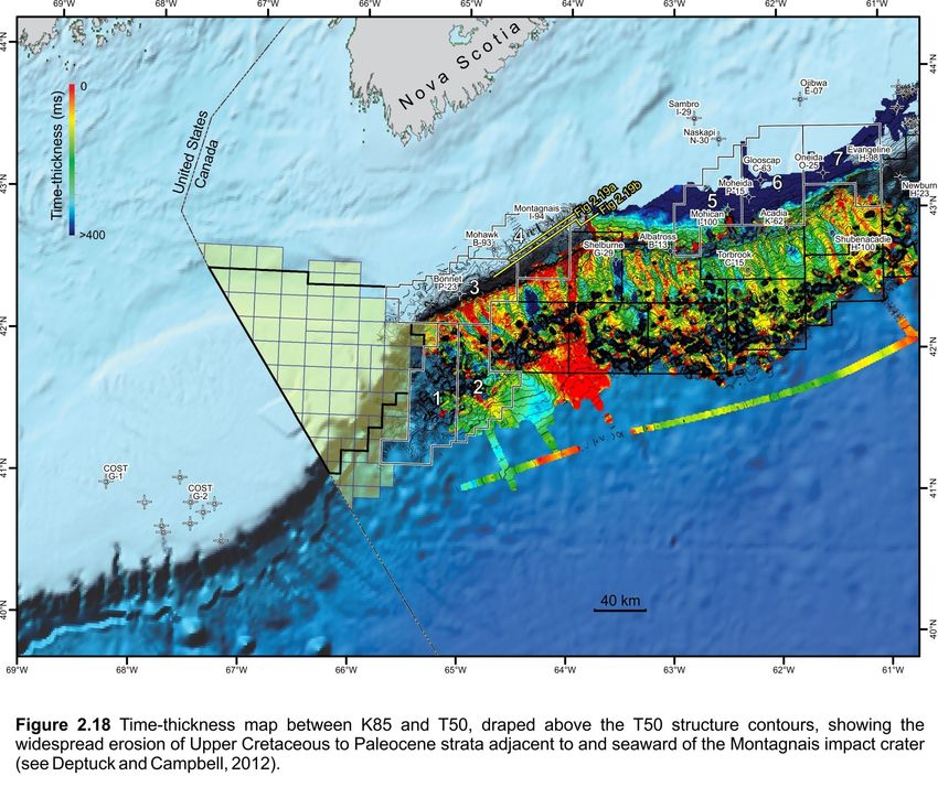
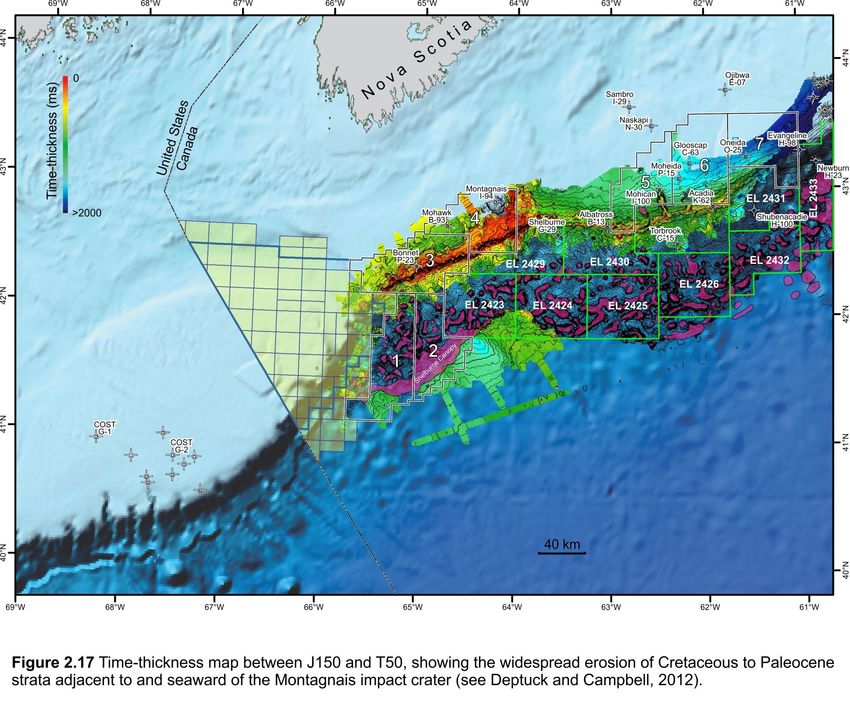
Figures 2.15, 2.16, 2.17, 2.18, 2.19) (see also Deptuck Cretaceous or earliest Cenozoic canyons sculpted by the
and Campbell 2012). That the Middle to Upper Jurassic Early Eocene T50 unconformity (Figure 2.22b). This
and potentially even Cretaceous shelf-edge deltas amplitude anomaly could also correspond to massive
delivered sand to the slope in Parcels 3 and 4 is reservoir units deposited during the ~50.5 Ma
supported by time-thickness maps in deepwater and Montagnais impact event, or shortly after from
amplitude extractions from the Barrington 3D survey turbulent flows carrying better sorted sand down the
(Figure 2.20). These extractions show clear evidence for slope as water resurged back towards the crater cavity
submarine channel systems in Jurassic, Cretaceous and shortly after the initial marine impact event (see
Tertiary strata, indicating that multiple turbidite Deptuck and Campbell, 2012). The associated
reservoir intervals are possible off southwestern Nova amplitude anomaly covers an area of about 266 km2.
Scotia. Both of these amplitude anomalies stack vertically,
producing a potentially very large stratigraphic trap.
Potential reservoirs could have been incorporated into a
number of structural and stratigraphic traps. Potential A key element of this trap is the widespread Montagnais
structural traps involve Jurassic to Earliest Cretaceous erosion surface that produces an angular unconformity
strata rotated and detached as rafts above the all along the Outer Jansa Scarp (e.g. Figures 2.15, 2.16).
autochthonous salt layer, and their raised edges may This angular unconformity was subsequently draped by
locally form traps draped by younger Cretaceous strata. widespread Late Eocene mudstones (Late Eocene
The most promising targets, however, are stratigraphic mudbelt/sub-unit 1c of Deptuck and Campbell, 2012),
traps in the seaward parts of Parcel 3 and 4 where producing an important regional seal. Although there
turbidites onlap the slope or where turbidite sands appears to be up-slope pinch-out or onlap of several of
were truncated by the T50 unconformity and later the deeper Cretaceous turbidite channels mentioned
draped by widespread Eocene mudstones, creating above, the presence of the angular unconformity and
unconformity traps (e.g. Figure 2.15). later regional seal reduces the risk of up-slope leakage
along channels that could compromise the integrity of
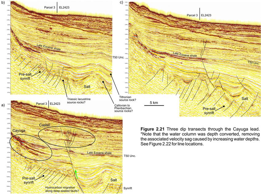
One potential stratigraphic trap is the Cayuga lead the stratigraphic trap. The Cayuga lead could be
captured in the Barrington 3D survey (Figures 2.21, analogous to the Buzzard field in the North Sea, which
2.22). It consists of a series of mid-Cretaceous to Early contains 400 million barrels of oil in Late Jurassic
Eocene amplitude anomalies interpreted to correspond
reservoirs that form a wedge-shaped stratigraphic trap
to turbidite channel reservoirs contained within a thinning onto the slope (Dore and Robbins 2005). The
combination up-slope pinch-out and angular Jubilee discovery of Ghana containing stacked Turonian
unconformity trap. Cayuga is found immediately down- turbidites (95 m of pay; ~700 mmboe recoverable) may
slope from the eroded carbonate bank edge (‘outer also be an appropriate analogue.
25Deptuck et al. 2015
CNSOPB Geoscience Open File Report, 2015-001MF, 49 p.

27
Deptuck et al. 2015
CNSOPB Geoscience Open File Report, 2015-001MF, 49 p.

29
Deptuck et al. 2015

Numerous similar amplitude anomalies are recognized
on 2D seismic profiles both west and east of the
Barrington 3D survey in Parcels 3 and 4, as well as
seaward into Parcels 1 and 2 where they onlap salt
structures, implying that potential turbidite onlap traps
could be widespread.             In addition, shallower
stratigraphic traps associated with younger Cenozoic
turbidites that onlap the steep slope are also possible,
and a wide variety of amplitude anomalies that could be
DHIs are present in Parcels 1 to 4 (e.g. Castel lead
identified in Figure 2.21). As Torbrook C-15 has shown,
however, some of the shallowest amplitude anomalies
could correspond to poorly consolidated low-velocity
siltstones (Kidston et al., 2007).
CNSOPB Geoscience Open File Report, 2015-001MF, 49 p.

31
Deptuck et al. 2015
CNSOPB Geoscience Open File Report, 2015-001MF, 49 p.

3. Central Region                                                  Tertiary to Late Triassic stratigraphic succession and
                                                                   recovered nine conventional cores from potential
Exploration History                                                reservoir intervals. It was drilled by Shell on the outer
The central part of the Scotian margin has been                    edge of the Scotian shelf in 153 m water to test a large
somewhat better explored than the western area, with               simple four-way closure above a low relief salt pillow as
four wells included with Parcels 5, 6, and 7 (Figure 1.1,          defined by the top Jurassic seismic horizon. A thick
2.2) and an additional five wells located nearby. The              shale-dominated upper Tertiary (Pliocene-Miocene)
eight wells tested several play types, though they                 section was first penetrated that unconformably
encountered no significant petroleum shows.                        overlies a thin Late Cretaceous section. This was
                                                                   followed by a thick Late to Middle Jurassic succession
In the Central region, exploration began in the late
                                                                   that had surprisingly little porosity. For the Abenaki
1960s on the shallow water Scotian Shelf as an
                                                                   Formation, this could be facies-related as the
extension of the activity around Sable Island to the east.
                                                                   limestones were mostly mudstones with few oolitic or
Following a number of seismic programs, five wells
                                                                   other grainstone lithologies. The early Jurassic Iroquois
were drilled in the 1970s to early 1980s to test
                                                                   Formation sandstones and dolomites were tight with
structural plays. A sixth well tested a shallow rollover
                                                                   the latter invariably anhydritic. At the base of the well,
anticline in the mid-1980s, and then interest turned to
                                                                   the     approximately     Sinemurian      age     Breakup
the deep water slope with two wells testing
                                                                   Unconformity is underlain by a thin (79 m) interval of
stratigraphic and structural traps. Following extensive,
                                                                   Late Triassic redbeds followed by 28 metres of Argo
basin-wide regional 2D seismic surveys in the late
                                                                   Formation salts. There were no hydrocarbon
1990s, the slope region was licensed by industry though
                                                                   accumulations or significant shows in any of the strata
resulting only in a single well drilled in 2003 to test a
                                                                   penetrated and the well ended at 4388 m TD in Argo
shallow stratigraphic play. No significant oil and gas
                                                                   salts.
shows were encountered in any wells.
                                                                   Petro-Canada Moheida P-15 (1977) was drilled in close
Oneida O-25 (1970) was the third well drilled in the
                                                                   proximity (~20 km NE) of Mohican I-100 in 112 m water.
Scotian Basin. It was operated by Shell to test a very
                                                                   It too was designed to test potential dolomite reservoirs
large (~225+ km2) unfaulted, low relief simple anticlinal
                                                                   in the Early Jurassic Iroquois Formation in a simple
closure on the LaHave Platform. Closure was mapped at
                                                                   structural closure above a basement feature. This large
the top Jurassic (Abenaki / Baccaro). Beneath the
                                                                   (~83 km2) elongate feature was defined by a seismic
stratigraphic succession was a very large northeast-
                                                                   horizon interpreted as the top Iroquois. The well was
southwest trending tilted basement ridge with its
                                                                   drilled on the feature’s crest and encountered a similar
northern edge defined by a northwest-dipping normal
                                                                   stratigraphic succession to I-100 but with a thicker
fault with considerable offset. The target horizons were
                                                                   Cretaceous interval. The Late Cretaceous Logan Canyon
the Cretaceous and Jurassic intervals. The Cretaceous
                                                                   Formation was shale dominated and while much
Logan Canyon and Missisauga formations were shale
                                                                   thinner, the Missisauga Formation was capped with a
dominated with a few large porous but wet sands. The
                                                                   thick porous fluvial sandstone though with no shows.
Jurassic Abenaki Formation was an oolitic limestone and
                                                                   The underlying Late Jurassic Abenaki Formation was
shale succession with minor sands, all of which were
                                                                   composed mostly of lime mudstones but with better
tight with only a few porous intervals. No hydrocarbon
                                                                   developed oolitic grainstones though the latter were
shows or zones were discovered in any of the units and
                                                                   tight. Some modest porosity was present in the
the well abandoned at 4106 m TD in Mohican
                                                                   targeted Iroquois Formation sandstones though the
Formation sandstones and dolomites.
                                                                   dolomites were tight. The postrift unconformity at 3848
Mohican I-100 (1972) is a key well on the western                  m capped the remaining 445 m of Mohican to Eurydice
Scotian Basin as it penetrated a near complete Late                Formation tight redbed sediments in which the well

                                                             33
Deptuck et al. 2015
ended at 4293 m. No hydrocarbon shows were present due to poor hole conditions (washout). However, the
in the well. resistivity logs, sidewall cores and cuttings all indicate
that the zone is tight. The well’s primary target zone
Chevron-Petro-Canada-Shell Acadia K-62 (1978) was
consisted of early Tertiary to Late Cretaceous age shale,
drilled to test a low-relief, narrow, elongate, bank-edge tight limestone and marl. No reservoir quality sands
structural closure delineated by seismic. Closure was were encountered though four conventional cores were
mapped on the footwall at the top of the Jurassic cut. The well was drilled to a TD of 4200m MD reaching
(Baccaro Mb.) that relied on closure against the main
the Middle Cenomanian upper Logan Canyon
hingeline down-to-the-basin fault. The initial section equivalent. Subsequent mapping has indicated that the
penetrated was a thick (~2400 m) Tertiary shale interpreted fan was an erosional remnant below the
succession. A mid-Cretaceous and later lower Tertiary Base Tertiary (Paleocene to Eocene) unconformity. The
unconformities removed most of the Cretaceous Shubenacadie structure is one of the larger remnants
sediments with only ~450 m of Dawson Canyon separating two divergent channel-dominated areas,
Formation and younger mudstones remaining. K-62 which contributed to it resembling a constructional fan
drilled a complete Abenaki Formation section (Roseway, on the older seismic. The main exploration implication,
Baccaro, Misaine, and Scatarie members). Except for also confirmed in the earlier Shelburne G-29 well, was
the Misaine, the carbonate members were composed of
that the Tertiary fan play remained tested.
various oolitic limestone lithologies with generally fair
to very good porosity. The top Roseway had Husky-Bow Valley Glooscap C-63 (1984) was designed
considerable dolomitization with very good to test a ~50 km2 drape closure over a basement high in
intercrystaline porosity. The expected dolomites of the the Mohican Graben in 122 m water. The feature relied
Early Iroquois Formation were not penetrated (i.e. were on some modest fault seal on the eastern flank that is
deeper) but instead a mixed succession of oolitic defined on horizons interpreted as the tops of the
grainstones, sandstones and shales of the Mohican Scatarie Member, Iroquois and Eurydice formations.
Formation with fair to good porosity in the carbonates. The primary target horizons were siliciclastics and
No oil staining or significant mud-gas shows were dolomites of the Middle-early Jurassic Mohican and
encountered in the well though three DSTs were run in Iroquois, and Late Triassic Eurydice formations.
the Abenaki but recovered only formation water. Well Secondary targets were within the shallower Abenaki
TD was at 5287 m in Aalenian to Bajocian age Mohican (carbonate) and Logan Canyon (siliciclastic) formations.
limestones. The Tertiary (Banquereau Formation) and Cretaceous
(Wyandot, Dawson Canyon, Logan Canyon and
Shell was the first operator to drill on the deep water Missisauga formations) units were present as
Scotian slope, with their Shubenacadie H-100 well prognosed and there were few reservoir quality sands
located in 1476.5 m water depth. This well falls outside in the latter formation. The underlying Abenaki
the Call parcels but has relevance to plays in the deep Formation limestones were also tight, and sandstones
water portions of Parcels 5 and 6. The well was of the Mohican and Iroquois formations had some fair
designed to test an interpreted Eocene turbidite fan porosity. A surprise was the presence of 152 m of
deposit on the paleoslope with a shallower (Miocene) tholeiitic basalts of earliest Jurassic age at the
seismic amplitude anomaly as a secondary target. The postulated top Eurydice Formation and beneath this salt
prognosed Miocene bright spot secondary target was of the Argo Formation. Thus the well results (and later
encountered at 2636 m MD and consisted of 25 m of
seismic mapping) revealed the interpreted basement
tight, very fine-grained, silty sandstone with no shows. feature was in fact a salt pillow of Late Triassic age. C-
The age of this sand is believed to be Early Pliocene 63 was devoid of any hydrocarbon shows and thus
rather than Miocene. Unfortunately, the sonic and
terminated at 4542.5 m in Argo Formation.
density log readings across this zone are questionableCNSOPB Geoscience Open File Report, 2015-001MF, 49 p.
Husky-Bow Valley next drilled Evangeline H-98 (1984) to the formation was composed of oolitic grainstones
evaluate a shallow anticline along the edge of the shelf some of which were dolomitized. Poor to fair porosity
in 174 m of water. The structure is a narrow, elongate was common in this section but with no significant
rollover anticline with fault-dependent closures mapped shows. Two mud gas peaks of ~100 TGUs were
at the interpreted top Logan Canyon Formation (~29 recorded at 3434-3440m and 3012m with partial loss
km2 closure) and near top Naskapi Member (~48 km2 circulation occurring over the sections but DSTs were
closure). Potential gas reservoirs were expected in the not attempted. The basal half of the Abenaki was
fluvial-shallow marine sandstones of the lower Logan mostly tight lime mudstone though with some good
Canyon (Cree Member) and upper Missisauga porosity in several dolomitic zones. The well went
formations. After penetrating the Tertiary and Late through about 100 m of the Callovian Misaine Member
Cretaceous Wyandot Formation chalks, the well entered shales and siltstones and ended at 4047.5 m TD.
a thick succession of shales and siltstones of the
Dawson Canyon and Logan Canyon formation. No EnCana Torbrook C-15 (2003) was the most recent well
significant sandstone reservoirs were encountered, drilled in the western half of the Scotian Basin and was
however two gas and high gravity oil (condensate) the third well in the region to test the Tertiary fan play
shows were found in the Logan Canyon Formation on the deep water Scotian Slope (1675 m water depth).
equivalent (Cree Member). The uppermost (4022-4070 The primary target was an interpreted Miocene-aged
m) was found in a Late Cenomanian age MFS interval of turbidite channel/fan system fed from sediments on the
fossiliferous, sandy lime mudstones with total gas units shelf via canyons and deposited in a paleotopographic
ranging from 1000-3300 TGU with associated oil low. The secondary target was interpreted as an older
(condensate) in drilling mud. The deeper show was in Miocene fan complex. Two of the canyon feeder
fractured shales (4801-4802 m @ 1400 TGU) systems were identified at the Mohican I-100 and
Moheida P-15 well locations updip on the shelf and
accompanied by a drilling break. When compared to the
seismic profiles it appears likely that this interval correlated with the Late Paleogene (Middle Oligocene)
intersected a large listric fault. The well did not reach relative sea level fall. Both channel/fan systems were
the targeted Missisauga Formation and was ended at defined by amplitude anomalies on 2D seismic. No
hydrocarbon bearing reservoir quality sands were
5044 m and was not tested.
encountered in the well. Encana’s primary target was
The Petro-Canada Albatross B-13 well (1985) was drilled penetrated at 2855 m and consisted of poorly
on a pronounced structural high at the edge of the consolidated siltstone and shale/claystone that
Abenaki bank margin on the deep water Scotian Slope generated a minor mud-gas response of 50-80 TGU. The
in 1341 m water. Like Shubenacadie H-100, this well secondary target was encountered at 2958 m and
also falls outside the Call parcels but has relevance to consisted of thin, tight, siltstone with no shows. The
plays in the deep water portions of Parcels 5 and 6. The well ended at 3600 m in early Tertiary sediments. The
feature is a long (14 km), narrow (~1.5 km) closure with post-drill interpretation was that that the anomaly was
an estimated 250 m vertical relief mapped at the top a classic slump feature with no related submarine fan
Abenaki (Baccaro). It is sealed on the seaward side by a deposition. It is most likely the chaotic internal nature
basin-dipping normal fault. Target horizons within the of the slumped mass gave rise to signal attributes that
Abenaki Formation were defined by high amplitude while interpreted as a fan bore no relationship to
reflections interpreted to be porous oolitic and reefal potential reservoir facies.
carbonate reservoirs. Beneath the thick (~1000 m) of
Tertiary age Banquereau Formation mudstones about
1200 m of Abenaki Formation carbonates were
penetrated, with most of the Cretaceous succession
removed by Tertiary erosion events. The upper half of
35Deptuck et al. 2015
CNSOPB Geoscience Open File Report, 2015-001MF, 49 p.

Geological Setting                                                 The Naskapi Ridge is the most prominent basement
The Central region described here is located west of the           element in the Central region. It forms a 4 to 22 km
Sable Subbasin, above the heavily faulted nose of the              wide northeast-trending flat-topped basement high
LaHave Platform, extending onto the central Scotian                composed of Early Paleozoic rocks with little or no
Slope (Figure 1.1, 2.1, 3.1). This area is dominated by            internal reflectivity. It can be followed easily along
two main geologic features - extensional, locally salt-            strike over a distance of 160 km. Its southwestern end
bearing rift basins that formed as Nova Scotia rifted and          terminates where it plunges sharply to the southwest
ultimately broke apart from Morocco, and a widespread              into a poorly defined (crossed by only 3 seismic profiles)
Middle to Upper Jurassic carbonate platform that                   but deep rift basin (up to 1.6 sec twt). Its northeastern
aggraded above these rift basins after continental                 end is narrow and is heavily faulted near Ojibwa E-07,
break-up. Recent efforts have focused on more careful              where its trajectory curves slightly to the north over its
mapping of the top of the crystalline basement and the             final 20 km. Here it separates faults that dip landward
distribution and character of synrift strata. This work            from those that dip seaward in what appears to be an
provides a clearer view of basement architecture as well           important relay or accommodation/transfer zone. The
as the structural development of rift basins. Several              northern edge of the Naskapi Ridge was penetrated by
important structural and stratigraphic elements                    Naskapi     N-30, which        encountered Paleozoic
characterize this region, and are described in more                metasedimentary rocks that probably correspond to the
detail below to provide geological context for NS15-1              Meguma Supergroup (Pe-Piper and Jansa 1999). The
Call for Bids Parcels 5, 6, and 7.                                 northeastern termination of the horst block was
                                                                   penetrated at Ojibway E-07, which encountered Middle
Basement Architecture                                              Paleozoic granites. Similar granites widely intrude
The LaHave Platform along the Central region of the                Meguma metasedimentary rocks on mainland Nova
Scotian margin is broken by a complex arrangement of
                                                                   Scotia (Jansa and Pe-Piper 1999). Unlike the Yarmouth
faults that offset Early Paleozoic crystalline basement            Arch, there is no distinct or consistent magnetic
and produce synrift depocentres separated by                       response across most of the Naskapi Ridge (Figure 2.8).
basement highs (Welsink et al. 1989; Wade and
MacLean, 1990). The dominant structural grain is                   The Naskapi Ridge separates the Naskapi Graben to the
northeast-southwest, and most faults (both major                   north from the Mohican Graben to the south (Figures
border faults and minor intrabasinal faults) dip                   3.1, 3.2, 3.3). Its northern edge corresponds to the main
landward, towards the northwest. Many of the border                landward (northwest) dipping border fault(s) of the
faults sole into landward dipping to sub-horizontal mid-           Naskapi Graben. Its southern flank is also offset by
crustal detachments or shear zones (e.g. Figure 3.2;               dominantly landward dipping fault (Figure 3.3). The
Welsink et al. 1989), similar to several other rift basins         faulted top basement surface plunges to the southeast,
of the Newark Supergroup (e.g. Manspeizer, 1988). On               away from the Naskapi Ridge, until it intersects the
reflection seismic profiles, these produce horizontal to           northwest dipping border faults that flank other
steeply inclined highly reflective intervals within the            basement highs like the Moheida Ridge (Figure 3.1).
crust that can commonly be correlated over distances of            The Moheida Ridge and the East Moheida Ridge that is
many tens of kilometres. Although the typical absence              offset from it (right-lateral) are structurally much more
of a strong, consistent impedance contrast between                 complicated than the Naskapi Ridge. They do not
crystalline basement and overlying synrift strata makes            consist of a single basement element, but are instead
correlation of a ‘top basement’ surface challenging,               characterized by a complex jumble of faulted basement
careful mapping guided by some of the better quality               blocks and synrift strata that are challenging to unravel.
surveys provides a clearer view of a number of
basement elements that are defined below (Figure 3.1).

                                                             37
Deptuck et al. 2015
CNSOPB Geoscience Open File Report, 2015-001MF, 49 p.

Figure 3.4 from the Blueberry 3D survey (CNSOPB                  termination; where there is a clear relay ramp). This
program number NS24-E043-004E) crosses the eastern               implies that the East Mohican Ridge developed along a
parts of the East Moheida Ridge. It shows that the ridge         right-lateral transfer zone.
is cored by an elevated basement element, but clear
synrift strata within a series of rotated fault blocks           Synrift to Early Postrift Structure and Stratigraphy
overlie this elevated basement element. A similar                In the landward portion of Figures 3.1 and 3.2a, a
situation exists near Glooscap C-63, Moheida P-15, and           prominent angular unconformity separates underlying
                                                                 synrift strata and eroded basement elements (like the
Mohican I-100 that were all drilled above or off the
flanks of the Moheida Ridge (Figure 3.1). Each of these          Naskapi Ridge) from later onlapping and draping postrift
wells bottomed in younger rift successions that veneer           reflections. This erosional surface corresponds to the
more heavily faulted older (and unpenetrated) rift               time-transgressive ‘postrift unconformity’ widely
intervals of unknown composition or age. It is unlikely          described in most of the Newark-style rift grabens
that early synrift deposits would have accumulated               across offshore eastern United States and Canada (e.g.
above topographically elevated basement blocks, thus             Grow et al. 1983; Manspeizer 1988; Hutchison and
we infer that the Moheida and East Moheida Ridges                Klitgord 1988; Poag, 1991). On the central Scotian
were developed sometime after rift extension and                 Shelf, strata below this surface were penetrated in
associated sedimentation had already begun. Such                 Glooscap C-63, Moheida P-15, and Mohican I-100 – all
features could represent inversion structures. The               in the Mohican Graben – and further landward at
Acadia Ridge and Shelburne Ridge have a similar                  Sambro I-29 (Figure 3.1).
character. On gravity data, the Moheida and East                 Glooscap C-63 encountered a 152 m thick interval of
Moheida ridges align with very strong positive                   tholeiitic basalt flows that is geochemically
anomalies that are commonly found along the shelf                indistinguishable from CAMP-related basalts like the
edge (Figure 2.9; Keen et al. 1990). The Acadia and              North Mountain Basalt exposed along the shores of the
Shelburne ridges, located seaward of the shelf-edge              Fundy Basin (Wade and MacLean, 1990; Pe-Piper et al.
anomaly, also produce an elevated gravity response.              1992). North Mountain Basalts have a known age of
In contrast to the common northeast-southwest grain              ~201 Ma (Kontak and Archibald 2003) and hence
of most basement elements, the East Mohican Ridge                approximate the Triassic-Jurassic boundary.         The
trends normal to this orientation. It consists of an             Glooscap volcanics produce a strong, distinct seismic
arcuate basement element that is roughly perpendicular           marker that is conformable with underlying strata
to the Naskapi and Moheida/East Moheida ridges. Both             (Figure 3.3). It has been correlated throughout parts of
the dip and strike profiles in Figure 3.2 cross this             the Mohican and Oneida grabens, as well as landward
important basement element, showing that synrift                 into the Naskapi Graben. In landward areas it has been
strata both thin and are heavily eroded across it. The           heavily eroded by the postrift unconformity; further
East Mohican Ridge produces a moderately strong                  seaward it is commonly located 500 to 700 ms (twt)
positive gravity anomaly (Figure 2.9). Basement depth            deeper than the postrift unconformity. This is because
increases abruptly to its west, across one or more               later periods of extension (an inversion) dropped the
prominent basement faults with a total throw of at least         volcanic layer below the level of regional erosion.
1.5 sec (twt). These faults define the eastern boundary          If the postrift unconformity is carried ‘low’, along the
of the Mohican Graben. The eastern flank of this high            conformable Glooscap volcanic reflection, a more
plunges more gradually beneath the Oneida Graben                 regional surface is produced that corresponds to our
(Figures 3.1, 3.2b). The East Mohican Ridge aligns with          J200 surface (Figures 3.3, 3.5a). This surface separates
right lateral offsets observed between Moheida and               pre-CAMP strata below (Triassic and older) from post-
East Moheida ridges (at its southern termination) and            CAMP strata above (Early Jurassic and younger). A
the Naskapi and East Naskapi ridges (at its northern             time-thickness map between J200 and the top of
                                                           39
You can also read


