CLIMATE CHANGE 2013 The Physical Science Basis - Summary for Policymakers
←
→
Page content transcription
If your browser does not render page correctly, please read the page content below
INTERGOV ERNMENTA L PA NEL ON   climate change

CLIMATE CHANGE 2013
The Physical Science Basis

Summary for Policymakers

 WG I

WORKING GROUP I CONTRIBUTION TO THE
FIFTH ASSESSMENT REPORT OF THE
INTERGOVERNMENTAL PANEL ON CLIMATE CHANGE
Climate Change 2013
The Physical Science Basis
Working Group I Contribution to the
Fifth Assessment Report of the
Intergovernmental Panel on Climate Change
Summary for Policymakers
Edited by
Thomas F. Stocker Dahe Qin
Working Group I Co-Chair Working Group I Co-Chair
University of Bern China Meteorological Administration
Gian-Kasper Plattner Melinda M.B. Tignor Simon K. Allen Judith Boschung
Director of Science Director of Operations Senior Science Officer Administrative Assistant
Alexander Nauels Yu Xia Vincent Bex Pauline M. Midgley
Science Assistant Science Officer IT Officer Head
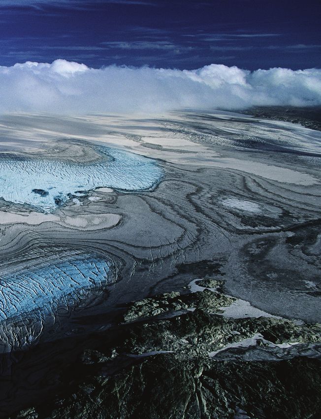
Working Group I Technical Support UnitCover photo: Folgefonna glacier on the high plateaus of Sørfjorden, Norway (60°03’ N - 6°20’ E) © Yann Arthus-Bertrand / Altitude. Printed October 2013 by the IPCC, Switzerland. Electronic copies of this Summary for Policymakers are available from the IPCC website www.ipcc.ch and the IPCC WGI AR5 website www.climatechange2013.org. © 2013 Intergovernmental Panel on Climate Change
Introduction                          Chapter 2

               Chapter 1 for Policymakers
               Summary

                                             iii
SPM1 Summary
for Policymakers
Drafting Authors:
Lisa V. Alexander (Australia), Simon K. Allen (Switzerland/New Zealand), Nathaniel L. Bindoff
(Australia), François-Marie Bréon (France), John A. Church (Australia), Ulrich Cubasch
(Germany), Seita Emori (Japan), Piers Forster (UK), Pierre Friedlingstein (UK/Belgium), Nathan
Gillett (Canada), Jonathan M. Gregory (UK), Dennis L. Hartmann (USA), Eystein Jansen
(Norway), Ben Kirtman (USA), Reto Knutti (Switzerland), Krishna Kumar Kanikicharla (India),
Peter Lemke (Germany), Jochem Marotzke (Germany), Valérie Masson-Delmotte (France),
Gerald A. Meehl (USA), Igor I. Mokhov (Russian Federation), Shilong Piao (China), Gian-Kasper
Plattner (Switzerland), Qin Dahe (China), Venkatachalam Ramaswamy (USA), David Randall
(USA), Monika Rhein (Germany), Maisa Rojas (Chile), Christopher Sabine (USA), Drew Shindell
(USA), Thomas F. Stocker (Switzerland), Lynne D. Talley (USA), David G. Vaughan (UK), Shang-
Ping Xie (USA)
Draft Contributing Authors:
Myles R. Allen (UK), Olivier Boucher (France), Don Chambers (USA), Jens Hesselbjerg Christensen
(Denmark), Philippe Ciais (France), Peter U. Clark (USA), Matthew Collins (UK), Josefino C.
Comiso (USA), Viviane Vasconcellos de Menezes (Australia/Brazil), Richard A. Feely (USA),
Thierry Fichefet (Belgium), Arlene M. Fiore (USA), Gregory Flato (Canada), Jan Fuglestvedt
(Norway), Gabriele Hegerl (UK/Germany), Paul J. Hezel (Belgium/USA), Gregory C. Johnson
(USA), Georg Kaser (Austria/Italy), Vladimir Kattsov (Russian Federation), John Kennedy (UK),
Albert M. G. Klein Tank (Netherlands), Corinne Le Quéré (UK), Gunnar Myhre (Norway), Timothy
Osborn (UK), Antony J. Payne (UK), Judith Perlwitz (USA), Scott Power (Australia), Michael
Prather (USA), Stephen R. Rintoul (Australia), Joeri Rogelj (Switzerland/Belgium), Matilde
Rusticucci (Argentina), Michael Schulz (Germany), Jan Sedláček (Switzerland), Peter A. Stott
(UK), Rowan Sutton (UK), Peter W. Thorne (USA/Norway/UK), Donald Wuebbles (USA)
This Summary for Policymakers should be cited as:
IPCC, 2013: Summary for Policymakers. In: Climate Change 2013: The Physical Science Basis. Contribution of
Working Group I to the Fifth Assessment Report of the Intergovernmental Panel on Climate Change [Stocker,
T.F., D. Qin, G.-K. Plattner, M. Tignor, S. K. Allen, J. Boschung, A. Nauels, Y. Xia, V. Bex and P.M. Midgley (eds.)].
Cambridge University Press, Cambridge, United Kingdom and New York, NY, USA.
1Summary for Policymakers
A. Introduction
The Working Group I contribution to the IPCC’s Fifth Assessment Report (AR5) considers new evidence of climate change
based on many independent scientific analyses from observations of the climate system, paleoclimate archives, theoretical
SPM
studies of climate processes and simulations using climate models. It builds upon the Working Group I contribution to the
IPCC’s Fourth Assessment Report (AR4), and incorporates subsequent new findings of research. As a component of the
fifth assessment cycle, the IPCC Special Report on Managing the Risks of Extreme Events and Disasters to Advance Climate
Change Adaptation (SREX) is an important basis for information on changing weather and climate extremes.
This Summary for Policymakers (SPM) follows the structure of the Working Group I report. The narrative is supported by a
series of overarching highlighted conclusions which, taken together, provide a concise summary. Main sections are introduced
with a brief paragraph in italics which outlines the methodological basis of the assessment.
The degree of certainty in key findings in this assessment is based on the author teams’ evaluations of underlying scientific
understanding and is expressed as a qualitative level of confidence (from very low to very high) and, when possible,
probabilistically with a quantified likelihood (from exceptionally unlikely to virtually certain). Confidence in the validity of
a finding is based on the type, amount, quality, and consistency of evidence (e.g., data, mechanistic understanding, theory,
models, expert judgment) and the degree of agreement1. Probabilistic estimates of quantified measures of uncertainty in a
finding are based on statistical analysis of observations or model results, or both, and expert judgment2. Where appropriate,
findings are also formulated as statements of fact without using uncertainty qualifiers. (See Chapter 1 and Box TS.1 for more
details about the specific language the IPCC uses to communicate uncertainty).
The basis for substantive paragraphs in this Summary for Policymakers can be found in the chapter sections of the underlying
report and in the Technical Summary. These references are given in curly brackets.
B. Observed Changes in the Climate System
Observations of the climate system are based on direct measurements and remote sensing from satellites and other platforms.
Global-scale observations from the instrumental era began in the mid-19th century for temperature and other variables, with
more comprehensive and diverse sets of observations available for the period 1950 onwards. Paleoclimate reconstructions
extend some records back hundreds to millions of years. Together, they provide a comprehensive view of the variability and
long-term changes in the atmosphere, the ocean, the cryosphere, and the land surface.
Warming of the climate system is unequivocal, and since the 1950s, many of the observed
changes are unprecedented over decades to millennia. The atmosphere and ocean have
warmed, the amounts of snow and ice have diminished, sea level has risen, and the
concentrations of greenhouse gases have increased (see Figures SPM.1, SPM.2, SPM.3 and
SPM.4). {2.2, 2.4, 3.2, 3.7, 4.2–4.7, 5.2, 5.3, 5.5–5.6, 6.2, 13.2}
1
In this Summary for Policymakers, the following summary terms are used to describe the available evidence: limited, medium, or robust; and for the degree of agreement:
low, medium, or high. A level of confidence is expressed using five qualifiers: very low, low, medium, high, and very high, and typeset in italics, e.g., medium confidence.
For a given evidence and agreement statement, different confidence levels can be assigned, but increasing levels of evidence and degrees of agreement are correlated with
increasing confidence (see Chapter 1 and Box TS.1 for more details).
2
In this Summary for Policymakers, the following terms have been used to indicate the assessed likelihood of an outcome or a result: virtually certain 99–100% probability,
very likely 90–100%, likely 66–100%, about as likely as not 33–66%, unlikely 0–33%, very unlikely 0–10%, exceptionally unlikely 0–1%. Additional terms (extremely likely:
95–100%, more likely than not >50–100%, and extremely unlikely 0–5%) may also be used when appropriate. Assessed likelihood is typeset in italics, e.g., very likely (see
Chapter 1 and Box TS.1 for more details).
2Summary for Policymakers
B.1 Atmosphere
Each of the last three decades has been successively warmer at the Earth’s surface than any
preceding decade since 1850 (see Figure SPM.1). In the Northern Hemisphere, 1983–2012
was likely the warmest 30-year period of the last 1400 years (medium confidence). {2.4, 5.3} SPM
• The globally averaged combined land and ocean surface temperature data as calculated by a linear trend, show a
warming of 0.85 [0.65 to 1.06] °C3, over the period 1880 to 2012, when multiple independently produced datasets exist.
The total increase between the average of the 1850–1900 period and the 2003–2012 period is 0.78 [0.72 to 0.85] °C,
based on the single longest dataset available 4 (see Figure SPM.1). {2.4}
• For the longest period when calculation of regional trends is sufficiently complete (1901 to 2012), almost the entire globe
has experienced surface warming (see Figure SPM.1). {2.4}
• In addition to robust multi-decadal warming, global mean surface temperature exhibits substantial decadal and
interannual variability (see Figure SPM.1). Due to natural variability, trends based on short records are very sensitive to
the beginning and end dates and do not in general reflect long-term climate trends. As one example, the rate of warming
over the past 15 years (1998–2012; 0.05 [–0.05 to 0.15] °C per decade), which begins with a strong El Niño, is smaller
than the rate calculated since 1951 (1951–2012; 0.12 [0.08 to 0.14] °C per decade)5. {2.4}
• Continental-scale surface temperature reconstructions show, with high confidence, multi-decadal periods during
the Medieval Climate Anomaly (year 950 to 1250) that were in some regions as warm as in the late 20th century.
These regional warm periods did not occur as coherently across regions as the warming in the late 20th century (high
confidence). {5.5}
• It is virtually certain that globally the troposphere has warmed since the mid-20th century. More complete observations
allow greater confidence in estimates of tropospheric temperature changes in the extratropical Northern Hemisphere
than elsewhere. There is medium confidence in the rate of warming and its vertical structure in the Northern Hemisphere
extra-tropical troposphere and low confidence elsewhere. {2.4}
• Confidence in precipitation change averaged over global land areas since 1901 is low prior to 1951 and medium
afterwards. Averaged over the mid-latitude land areas of the Northern Hemisphere, precipitation has increased since
1901 (medium confidence before and high confidence after 1951). For other latitudes area-averaged long-term positive
or negative trends have low confidence (see Figure SPM.2). {TS TFE.1, Figure 2; 2.5}
• Changes in many extreme weather and climate events have been observed since about 1950 (see Table SPM.1 for
details). It is very likely that the number of cold days and nights has decreased and the number of warm days and nights
has increased on the global scale6. It is likely that the frequency of heat waves has increased in large parts of Europe,
Asia and Australia. There are likely more land regions where the number of heavy precipitation events has increased than
where it has decreased. The frequency or intensity of heavy precipitation events has likely increased in North America and
Europe. In other continents, confidence in changes in heavy precipitation events is at most medium. {2.6}
3
In the WGI contribution to the AR5, uncertainty is quantified using 90% uncertainty intervals unless otherwise stated. The 90% uncertainty interval, reported in square
brackets, is expected to have a 90% likelihood of covering the value that is being estimated. Uncertainty intervals are not necessarily symmetric about the corresponding
best estimate. A best estimate of that value is also given where available.
4
Both methods presented in this bullet were also used in AR4. The first calculates the difference using a best fit linear trend of all points between 1880 and 2012. The second
calculates the difference between averages for the two periods 1850–1900 and 2003–2012. Therefore, the resulting values and their 90% uncertainty intervals are not
directly comparable. {2.4}
5
Trends for 15-year periods starting in 1995, 1996, and 1997 are 0.13 [0.02 to 0.24] °C per decade, 0.14 [0.03 to 0.24] °C per decade, and, 0.07 [–0.02 to 0.18] °C per
decade, respectively.
6
See the Glossary for the definition of these terms: cold days/cold nights, warm days/warm nights, heat waves.
3Summary for Policymakers
Observed globally averaged combined land and ocean
(a) surface temperature anomaly 1850–2012
0.6
Annual average
0.4
SPM
0.2
Temperature anomaly (°C) relative to 1961–1990
0.0
−0.2
−0.4
−0.6
0.6
Decadal average
0.4
0.2
0.0
−0.2
−0.4
−0.6
1850 1900 1950 2000
Year
(b) Observed change in surface temperature 1901–2012
−0.6 −0.4 −0.2 0 0.2 0.4 0.6 0.8 1.0 1.25 1.5 1.75 2.5
(°C)
Figure SPM.1 | (a) Observed global mean combined land and ocean surface temperature anomalies, from 1850 to 2012 from three data sets. Top panel:
annual mean values. Bottom panel: decadal mean values including the estimate of uncertainty for one dataset (black). Anomalies are relative to the mean
of 1961−1990. (b) Map of the observed surface temperature change from 1901 to 2012 derived from temperature trends determined by linear regression
from one dataset (orange line in panel a). Trends have been calculated where data availability permits a robust estimate (i.e., only for grid boxes with
greater than 70% complete records and more than 20% data availability in the first and last 10% of the time period). Other areas are white. Grid boxes
where the trend is significant at the 10% level are indicated by a + sign. For a listing of the datasets and further technical details see the Technical Summary
Supplementary Material. {Figures 2.19–2.21; Figure TS.2}
4Table SPM.1 | Extreme weather and climate events: Global-scale assessment of recent observed changes, human contribution to the changes, and projected further changes for the early (2016–2035) and late (2081–2100) 21st century.
Bold indicates where the AR5 (black) provides a revised* global-scale assessment from the SREX (blue) or AR4 (red). Projections for early 21st century were not provided in previous assessment reports. Projections in the AR5 are relative to
the reference period of 1986–2005, and use the new Representative Concentration Pathway (RCP) scenarios (see Box SPM.1) unless otherwise specified. See the Glossary for definitions of extreme weather and climate events.
Phenomenon and Assessment that changes occurred (typically Assessment of a human Likelihood of further changes
direction of trend since 1950 unless otherwise indicated) contribution to observed changes Early 21st century Late 21st century
Warmer and/or fewer Very likely {2.6} Very likely {10.6} Likely {11.3} Virtually certain {12.4}
cold days and nights Very likely Likely Virtually certain
over most land areas Very likely Likely Virtually certain
Warmer and/or more Very likely {2.6} Very likely {10.6} Likely {11.3} Virtually certain {12.4}
frequent hot days and Very likely Likely Virtually certain
nights over most land areas Very likely Likely (nights only) Virtually certain
Warm spells/heat waves. Medium confidence on a global scale Likelya Not formally assessedb Very likely
Frequency and/or duration Likely in large parts of Europe, Asia and Australia {2.6} {10.6} {11.3} {12.4}
increases over most Medium confidence in many (but not all) regions Not formally assessed Very likely
land areas Likely More likely than not Very likely
Heavy precipitation events. Likely more land areas with increases than decreasesc Medium confidence Likely over many land areas Very likely over most of the mid-latitude land
Increase in the frequency, {2.6} {7.6, 10.6} {11.3} masses and over wet tropical regions {12.4}
intensity, and/or amount Likely more land areas with increases than decreases Medium confidence Likely over many areas
of heavy precipitation Likely over most land areas More likely than not Very likely over most land areas
Low confidence on a global scale Low confidence {10.6} Low confidenceg {11.3} Likely (medium confidence) on a regional to
Increases in intensity Likely changes in some regionsd {2.6} global scaleh {12.4}
and/or duration of drought Medium confidence in some regions Medium confidence f Medium confidence in some regions
Likely in many regions, since 1970e More likely than not Likelye
Low confidence in long term (centennial) changes Low confidencei Low confidence More likely than not in the Western North Pacific
Virtually certain in North Atlantic since 1970 {2.6} {10.6} {11.3} and North Atlantic j {14.6}
Increases in intense
tropical cyclone activity Low confidence Low confidence More likely than not in some basins
Likely in some regions, since 1970 More likely than not Likely
Increased incidence and/or Likely (since 1970) {3.7} Likely k {3.7} Likely l {13.7} Very likely l {13.7}
magnitude of extreme Likely (late 20th century) Likely k Very likely m
high sea level Likely More likely than not k Likely
* The direct comparison of assessment findings between reports is difficult. For some climate variables, different aspects have been assessed, and the revised guidance note on uncertainties has been used for the SREX and AR5. The availability of new information, improved scientific understanding, continued
analyses of data and models, and specific differences in methodologies applied in the assessed studies, all contribute to revised assessment findings.
Notes:
a
Attribution is based on available case studies. It is likely that human influence has more than doubled the probability of occurrence of some observed heat waves in some locations.
b
Models project near-term increases in the duration, intensity and spatial extent of heat waves and warm spells.
c
In most continents, confidence in trends is not higher than medium except in North America and Europe where there have been likely increases in either the frequency or intensity of heavy precipitation with some seasonal and/or regional variation. It is very likely that there have been increases in central
North America.
d
The frequency and intensity of drought has likely increased in the Mediterranean and West Africa, and likely decreased in central North America and north-west Australia.
e
AR4 assessed the area affected by drought.
f
SREX assessed medium confidence that anthropogenic influence had contributed to some changes in the drought patterns observed in the second half of the 20th century, based on its attributed impact on precipitation and temperature changes. SREX assessed low confidence in the attribution of changes
in droughts at the level of single regions.
g There is low confidence in projected changes in soil moisture.
h Regional to global-scale projected decreases in soil moisture and increased agricultural drought are likely (medium confidence) in presently dry regions by the end of this century under the RCP8.5 scenario. Soil moisture drying in the Mediterranean, Southwest US and southern African regions is consistent
with projected changes in Hadley circulation and increased surface temperatures, so there is high confidence in likely surface drying in these regions by the end of this century under the RCP8.5 scenario.
i There is medium confidence that a reduction in aerosol forcing over the North Atlantic has contributed at least in part to the observed increase in tropical cyclone activity since the 1970s in this region.
j Based on expert judgment and assessment of projections which use an SRES A1B (or similar) scenario.
Summary for Policymakers
k Attribution is based on the close relationship between observed changes in extreme and mean sea level.
5
l There is high confidence that this increase in extreme high sea level will primarily be the result of an increase in mean sea level. There is low confidence in region-specific projections of storminess and associated storm surges.
m SREX assessed it to be very likely that mean sea level rise will contribute to future upward trends in extreme coastal high water levels.
SPMSummary for Policymakers
Observed change in annual precipitation over land
1901– 2010 1951– 2010
SPM
−100 −50 −25 −10 −5 −2.5 0 2.5 5 10 25 50 100
(mm yr per decade)
-1
Figure SPM.2 | Maps of observed precipitation change from 1901 to 2010 and from 1951 to 2010 (trends in annual accumulation calculated using the
same criteria as in Figure SPM.1) from one data set. For further technical details see the Technical Summary Supplementary Material. {TS TFE.1, Figure 2;
Figure 2.29}
B.2 Ocean
Ocean warming dominates the increase in energy stored in the climate system, accounting
for more than 90% of the energy accumulated between 1971 and 2010 (high confidence).
It is virtually certain that the upper ocean (0−700 m) warmed from 1971 to 2010 (see Figure
SPM.3), and it likely warmed between the 1870s and 1971. {3.2, Box 3.1}
• On a global scale, the ocean warming is largest near the surface, and the upper 75 m warmed by 0.11 [0.09 to 0.13] °C
per decade over the period 1971 to 2010. Since AR4, instrumental biases in upper-ocean temperature records have been
identified and reduced, enhancing c onfidence in the assessment of change. {3.2}
• It is likely that the ocean warmed between 700 and 2000 m from 1957 to 2009. Sufficient observations are available for
the period 1992 to 2005 for a global assessment of temperature change below 2000 m. There were likely no significant
observed temperature trends between 2000 and 3000 m for this period. It is likely that the ocean warmed from 3000 m
to the bottom for this period, with the largest warming observed in the Southern Ocean. {3.2}
• More than 60% of the net energy increase in the climate system is stored in the upper ocean (0–700 m) during the
relatively well-sampled 40-year period from 1971 to 2010, and about 30% is stored in the ocean below 700 m. The
increase in upper ocean heat content during this time period estimated from a linear trend is likely 17 [15 to 19] ×
1022 J 7 (see Figure SPM.3). {3.2, Box 3.1}
• It is about as likely as not that ocean heat content from 0–700 m increased more slowly during 2003 to 2010 than during
1993 to 2002 (see Figure SPM.3). Ocean heat uptake from 700–2000 m, where interannual variability is smaller, likely
continued unabated from 1993 to 2009. {3.2, Box 9.2}
• It is very likely that regions of high salinity where evaporation dominates have become more saline, while regions of
low salinity where precipitation dominates have become fresher since the 1950s. These regional trends in ocean salinity
provide indirect evidence that evaporation and precipitation over the oceans have changed (medium confidence). {2.5,
3.3, 3.5}
• There is no observational evidence of a trend in the Atlantic Meridional Overturning Circulation (AMOC), based on the
decade-long record of the complete AMOC and longer records of individual AMOC components. {3.6}
7 A constant supply of heat through the ocean surface at the rate of 1 W m–2 for 1 year would increase the ocean heat content by 1.1 × 10²² J.
6Summary for Policymakers
B.3 Cryosphere
Over the last two decades, the Greenland and Antarctic ice sheets have been losing mass,
glaciers have continued to shrink almost worldwide, and Arctic sea ice and Northern
Hemisphere spring snow cover have continued to decrease in extent (high confidence) (see SPM
Figure SPM.3). {4.2–4.7}
• The average rate of ice loss8 from glaciers around the world, excluding glaciers on the periphery of the ice sheets9, was
very likely 226 [91 to 361] Gt yr−1 over the period 1971 to 2009, and very likely 275 [140 to 410] Gt yr−1 over the period
1993 to 200910. {4.3}
• The average rate of ice loss from the Greenland ice sheet has very likely substantially increased from 34 [–6 to 74] Gt yr–1
over the period 1992 to 2001 to 215 [157 to 274] Gt yr–1 over the period 2002 to 2011. {4.4}
• The average rate of ice loss from the Antarctic ice sheet has likely increased from 30 [–37 to 97] Gt yr–1 over the period
1992–2001 to 147 [72 to 221] Gt yr–1 over the period 2002 to 2011. There is very high confidence that these losses are
mainly from the northern Antarctic Peninsula and the Amundsen Sea sector of West Antarctica. {4.4}
• The annual mean Arctic sea ice extent decreased over the period 1979 to 2012 with a rate that was very likely in the
range 3.5 to 4.1% per decade (range of 0.45 to 0.51 million km2 per decade), and very likely in the range 9.4 to 13.6%
per decade (range of 0.73 to 1.07 million km2 per decade) for the summer sea ice minimum (perennial sea ice). The
average decrease in decadal mean extent of Arctic sea ice has been most rapid in summer (high confidence); the spatial
extent has decreased in every season, and in every successive decade since 1979 (high confidence) (see Figure SPM.3).
There is medium confidence from reconstructions that over the past three decades, Arctic summer sea ice retreat was
unprecedented and sea surface temperatures were anomalously high in at least the last 1,450 years. {4.2, 5.5}
• It is very likely that the annual mean Antarctic sea ice extent increased at a rate in the range of 1.2 to 1.8% per decade
(range of 0.13 to 0.20 million km2 per decade) between 1979 and 2012. There is high confidence that there are strong
regional differences in this annual rate, with extent increasing in some regions and decreasing in others. {4.2}
• There is very high confidence that the extent of Northern Hemisphere snow cover has decreased since the mid-20th
century (see Figure SPM.3). Northern Hemisphere snow cover extent decreased 1.6 [0.8 to 2.4] % per decade for March
and April, and 11.7 [8.8 to 14.6] % per decade for June, over the 1967 to 2012 period. During this period, snow cover
extent in the Northern Hemisphere did not show a statistically significant increase in any month. {4.5}
• There is high confidence that permafrost temperatures have increased in most regions since the early 1980s. Observed
warming was up to 3°C in parts of Northern Alaska (early 1980s to mid-2000s) and up to 2°C in parts of the Russian
European North (1971 to 2010). In the latter region, a considerable reduction in permafrost thickness and areal extent
has been observed over the period 1975 to 2005 (medium confidence). {4.7}
• Multiple lines of evidence support very substantial Arctic warming since the mid-20th century. {Box 5.1, 10.3}
8
All references to ‘ice loss’ or ‘mass loss’ refer to net ice loss, i.e., accumulation minus melt and iceberg calving.
9
For methodological reasons, this assessment of ice loss from the Antarctic and Greenland ice sheets includes change in the glaciers on the periphery. These peripheral glaciers
are thus excluded from the values given for glaciers.
10
100 Gt yr−1 of ice loss is equivalent to about 0.28 mm yr−1 of global mean sea level rise.
7Summary for Policymakers
(a) Northern Hemisphere spring snow cover
45
40
(million km2)
SPM
35
30
1900 1920 1940 1960 1980 2000
Year
(b) Arctic summer sea ice extent
14
12
(million km2)
10
8
6
4
1900 1920 1940 1960 1980 2000
Year
(c) Change in global average upper ocean heat content
20
10
(1022 J)
0
−10
−20
1900 1920 1940 1960 1980 2000
Year
(d) Global average sea level change
200
150
100
(mm)
50
0
−50
1900 1920 1940 1960 1980 2000
Year
Figure SPM.3 | Multiple observed indicators of a changing global climate: (a) Extent of Northern Hemisphere March-April (spring) average snow cover; (b)
extent of Arctic July-August-September (summer) average sea ice; (c) change in global mean upper ocean (0–700 m) heat content aligned to 2006−2010,
and relative to the mean of all datasets for 1970; (d) global mean sea level relative to the 1900–1905 mean of the longest running dataset, and with all
datasets aligned to have the same value in 1993, the first year of satellite altimetry data. All time-series (coloured lines indicating different data sets) show
annual values, and where assessed, uncertainties are indicated by coloured shading. See Technical Summary Supplementary Material for a listing of the
datasets. {Figures 3.2, 3.13, 4.19, and 4.3; FAQ 2.1, Figure 2; Figure TS.1}
8Summary for Policymakers
B.4 Sea Level
The rate of sea level rise since the mid-19th century has been larger than the mean rate
during the previous two millennia (high confidence). Over the period 1901 to 2010, global
mean sea level rose by 0.19 [0.17 to 0.21] m (see Figure SPM.3). {3.7, 5.6, 13.2} SPM
• Proxy and instrumental sea level data indicate a transition in the late 19th to the early 20th century from relatively low
mean rates of rise over the previous two millennia to higher rates of rise (high confidence). It is likely that the rate of
global mean sea level rise has continued to increase since the early 20th century. {3.7, 5.6, 13.2}
• It is very likely that the mean rate of global averaged sea level rise was 1.7 [1.5 to 1.9] mm yr–1 between 1901 and 2010,
2.0 [1.7 to 2.3] mm yr–1 between 1971 and 2010, and 3.2 [2.8 to 3.6] mm yr–1 between 1993 and 2010. Tide-gauge and
satellite altimeter data are consistent regarding the higher rate of the latter period. It is likely that similarly high rates
occurred between 1920 and 1950. {3.7}
• Since the early 1970s, glacier mass loss and ocean thermal expansion from warming together explain about 75% of the
observed global mean sea level rise (high confidence). Over the period 1993 to 2010, global mean sea level rise is, with
high confidence, consistent with the sum of the observed contributions from ocean thermal expansion due to warming
(1.1 [0.8 to 1.4] mm yr–1), from changes in glaciers (0.76 [0.39 to 1.13] mm yr–1), Greenland ice sheet (0.33 [0.25 to 0.41]
mm yr–1), Antarctic ice sheet (0.27 [0.16 to 0.38] mm yr–1), and land water storage (0.38 [0.26 to 0.49] mm yr–1). The sum
of these contributions is 2.8 [2.3 to 3.4] mm yr–1. {13.3}
• There is very high confidence that maximum global mean sea level during the last interglacial period (129,000 to 116,000
years ago) was, for several thousand years, at least 5 m higher than present, and high confidence that it did not exceed
10 m above present. During the last interglacial period, the Greenland ice sheet very likely contributed between 1.4 and
4.3 m to the higher global mean sea level, implying with medium confidence an additional contribution from the Antarctic
ice sheet. This change in sea level occurred in the context of different orbital forcing and with high-latitude surface
temperature, averaged over several thousand years, at least 2°C warmer than present (high confidence). {5.3, 5.6}
B.5 Carbon and Other Biogeochemical Cycles
The atmospheric concentrations of carbon dioxide, methane, and nitrous oxide have
increased to levels unprecedented in at least the last 800,000 years. Carbon dioxide
concentrations have increased by 40% since pre-industrial times, primarily from fossil fuel
emissions and secondarily from net land use change emissions. The ocean has absorbed
about 30% of the emitted anthropogenic carbon dioxide, causing ocean acidification (see
Figure SPM.4). {2.2, 3.8, 5.2, 6.2, 6.3}
• The atmospheric concentrations of the greenhouse gases carbon dioxide (CO2), methane (CH4), and nitrous oxide (N2O)
have all increased since 1750 due to human activity. In 2011 the concentrations of these greenhouse gases were 391
ppm11, 1803 ppb, and 324 ppb, and exceeded the pre-industrial levels by about 40%, 150%, and 20%, respectively. {2.2,
5.2, 6.1, 6.2}
• Concentrations of CO2, CH4, and N2O now substantially exceed the highest concentrations recorded in ice cores during
the past 800,000 years. The mean rates of increase in atmospheric concentrations over the past century are, with very
high confidence, unprecedented in the last 22,000 years. {5.2, 6.1, 6.2}
11
ppm (parts per million) or ppb (parts per billion, 1 billion = 1,000 million) is the ratio of the number of gas molecules to the total number of molecules of dry air. For example,
300 ppm means 300 molecules of a gas per million molecules of dry air.
9Summary for Policymakers
• Annual CO2 emissions from fossil fuel combustion and cement production were 8.3 [7.6 to 9.0] GtC12 yr–1 averaged over
2002–2011 (high confidence) and were 9.5 [8.7 to 10.3] GtC yr–1 in 2011, 54% above the 1990 level. Annual net CO2
emissions from anthropogenic land use change were 0.9 [0.1 to 1.7] GtC yr–1 on average during 2002 to 2011 (medium
confidence). {6.3}
SPM
• From 1750 to 2011, CO2 emissions from fossil fuel combustion and cement production have released 375 [345 to 405]
GtC to the atmosphere, while deforestation and other land use change are estimated to have released 180 [100 to 260]
GtC. This results in cumulative anthropogenic emissions of 555 [470 to 640] GtC. {6.3}
• Of these cumulative anthropogenic CO2 emissions, 240 [230 to 250] GtC have accumulated in the atmosphere, 155 [125
to 185] GtC have been taken up by the ocean and 160 [70 to 250] GtC have accumulated in natural terrestrial ecosystems
(i.e., the cumulative residual land sink). {Figure TS.4, 3.8, 6.3}
• Ocean acidification is quantified by decreases in pH13. The pH of ocean surface water has decreased by 0.1 since the
beginning of the industrial era (high confidence), corresponding to a 26% increase in hydrogen ion concentration (see
Figure SPM.4). {3.8, Box 3.2}
Atmospheric CO2
(a) 400
380
CO2 (ppm)
360
340
320
300
1950 1960 1970 1980 1990 2000 2010
Year
Surface ocean CO2 and pH
(b) 400
380
pCO2 (μatm)
360
340
320
8.12
in situ pH unit
8.09
8.06
1950 1960 1970 1980 1990 2000 2010
Year
Figure SPM.4 | Multiple observed indicators of a changing global carbon cycle: (a) atmospheric concentrations of carbon dioxide (CO2) from Mauna Loa
(19°32’N, 155°34’W – red) and South Pole (89°59’S, 24°48’W – black) since 1958; (b) partial pressure of dissolved CO2 at the ocean surface (blue curves)
and in situ pH (green curves), a measure of the acidity of ocean water. Measurements are from three stations from the Atlantic (29°10’N, 15°30’W – dark
blue/dark green; 31°40’N, 64°10’W – blue/green) and the Pacific Oceans (22°45’N, 158°00’W − light blue/light green). Full details of the datasets shown
here are provided in the underlying report and the Technical Summary Supplementary Material. {Figures 2.1 and 3.18; Figure TS.5}
12
1 Gigatonne of carbon = 1 GtC = 1015 grams of carbon. This corresponds to 3.667 GtCO2.
13
pH is a measure of acidity using a logarithmic scale: a pH decrease of 1 unit corresponds to a 10-fold increase in hydrogen ion concentration, or acidity.
10Summary for Policymakers
C. Drivers of Climate Change
Natural and anthropogenic substances and processes that alter the Earth’s energy budget are drivers of climate change.
Radiative forcing14 (RF) quantifies the change in energy fluxes caused by changes in these drivers for 2011 relative to 1750,
unless otherwise indicated. Positive RF leads to surface warming, negative RF leads to surface cooling. RF is estimated based
on in-situ and remote observations, properties of greenhouse gases and aerosols, and calculations using numerical models SPM
representing observed processes. Some emitted compounds affect the atmospheric concentration of other substances. The RF
can be reported based on the concentration changes of each substance15. Alternatively, the emission-based RF of a compound
can be reported, which provides a more direct link to human activities. It includes contributions from all substances affected
by that emission. The total anthropogenic RF of the two approaches are identical when considering all drivers. Though both
approaches are used in this Summary for Policymakers, emission-based RFs are emphasized.
Total radiative forcing is positive, and has led to an uptake of energy by the climate system.
The largest contribution to total radiative forcing is caused by the increase in the atmospheric
concentration of CO2 since 1750 (see Figure SPM.5). {3.2, Box 3.1, 8.3, 8.5}
• The total anthropogenic RF for 2011 relative to 1750 is 2.29 [1.13 to 3.33] W m−2 (see Figure SPM.5), and it has increased
more rapidly since 1970 than during prior decades. The total anthropogenic RF best estimate for 2011 is 43% higher than
that reported in AR4 for the year 2005. This is caused by a combination of continued growth in most greenhouse gas
concentrations and improved estimates of RF by aerosols indicating a weaker net cooling effect (negative RF). {8.5}
• The RF from emissions of well-mixed greenhouse gases (CO2, CH4, N2O, and Halocarbons) for 2011 relative to 1750 is
3.00 [2.22 to 3.78] W m–2 (see Figure SPM.5). The RF from changes in concentrations in these gases is 2.83 [2.26 to 3.40]
W m–2. {8.5}
• Emissions of CO2 alone have caused an RF of 1.68 [1.33 to 2.03] W m–2 (see Figure SPM.5). Including emissions of other
carbon-containing gases, which also contributed to the increase in CO2 concentrations, the RF of CO2 is 1.82 [1.46 to
2.18] W m–2. {8.3, 8.5}
• Emissions of CH4 alone have caused an RF of 0.97 [0.74 to 1.20] W m−2 (see Figure SPM.5). This is much larger than the
concentration-based estimate of 0.48 [0.38 to 0.58] W m−2 (unchanged from AR4). This difference in estimates is caused
by concentration changes in ozone and stratospheric water vapour due to CH4 emissions and other emissions indirectly
affecting CH4. {8.3, 8.5}
• Emissions of stratospheric ozone-depleting halocarbons have caused a net positive RF of 0.18 [0.01 to 0.35] W m−2 (see
Figure SPM.5). Their own positive RF has outweighed the negative RF from the ozone depletion that they have induced.
The positive RF from all halocarbons is similar to the value in AR4, with a reduced RF from CFCs but increases from many
of their substitutes. {8.3, 8.5}
• Emissions of short-lived gases contribute to the total anthropogenic RF. Emissions of carbon monoxide (CO) are virtually
certain to have induced a positive RF, while emissions of nitrogen oxides (NOx) are likely to have induced a net negative
RF (see Figure SPM.5). {8.3, 8.5}
• The RF of the total aerosol effect in the atmosphere, which includes cloud adjustments due to aerosols, is –0.9 [–1.9 to
−0.1] W m−2 (medium confidence), and results from a negative forcing from most aerosols and a positive contribution
14
The strength of drivers is quantified as Radiative Forcing (RF) in units watts per square metre (W m–2) as in previous IPCC assessments. RF is the change in energy flux
caused by a driver, and is calculated at the tropopause or at the top of the atmosphere. In the traditional RF concept employed in previous IPCC reports all surface and
tropospheric conditions are kept fixed. In calculations of RF for well-mixed greenhouse gases and aerosols in this report, physical variables, except for the ocean and sea
ice, are allowed to respond to perturbations with rapid adjustments. The resulting forcing is called Effective Radiative Forcing (ERF) in the underlying report. This change
reflects the scientific progress from previous assessments and results in a better indication of the eventual temperature response for these drivers. For all drivers other than
well-mixed greenhouse gases and aerosols, rapid adjustments are less well characterized and assumed to be small, and thus the traditional RF is used. {8.1}
15
This approach was used to report RF in the AR4 Summary for Policymakers.
11Summary for Policymakers
from black carbon absorption of solar radiation. There is high confidence that aerosols and their interactions with clouds
have offset a substantial portion of global mean forcing from well-mixed greenhouse gases. They continue to contribute
the largest uncertainty to the total RF estimate. {7.5, 8.3, 8.5}
• The forcing from stratospheric volcanic aerosols can have a large impact on the climate for some years after volcanic
SPM eruptions. Several small eruptions have caused an RF of –0.11 [–0.15 to –0.08] W m–2 for the years 2008 to 2011, which
is approximately twice as strong as during the years 1999 to 2002. {8.4}
• The RF due to changes in solar irradiance is estimated as 0.05 [0.00 to 0.10] W m−2 (see Figure SPM.5). Satellite obser-
vations of total solar irradiance changes from 1978 to 2011 indicate that the last solar minimum was lower than the
previous two. This results in an RF of –0.04 [–0.08 to 0.00] W m–2 between the most recent minimum in 2008 and the
1986 minimum. {8.4}
• The total natural RF from solar irradiance changes and stratospheric volcanic aerosols made only a small contribution to
the net radiative forcing throughout the last century, except for brief periods after large volcanic eruptions. {8.5}
Emitted Resulting atmospheric Level of
compound drivers
Radiative forcing by emissions and drivers confidence
CO2 CO2 1.68 [1.33 to 2.03] VH
Well-mixed greenhouse gases
CH4 CO2 H2Ostr O3 CH4 0.97 [0.74 to 1.20] H
Halo-
O3 CFCs HCFCs 0.18 [0.01 to 0.35] H
carbons
N 2O N 2O 0.17 [0.13 to 0.21] VH
CO
Anthropogenic
CO2 CH4 O3 0.23 [0.16 to 0.30] M
Short lived gases and aerosols
NMVOC CO2 CH4 O3 0.10 [0.05 to 0.15] M
NOx Nitrate CH4 O3 -0.15 [-0.34 to 0.03] M
Aerosols and Mineral dust Sulphate Nitrate
precursors Organic carbon Black carbon
-0.27 [-0.77 to 0.23] H
(Mineral dust,
SO2, NH3,
Organic carbon
Cloud adjustments
-0.55 [-1.33 to -0.06] L
and Black carbon) due to aerosols
Albedo change
-0.15 [-0.25 to -0.05] M
due to land use
Changes in
Natural
0.05 [0.00 to 0.10] M
solar irradiance
2.29 [1.13 to 3.33]
2011 H
Total anthropogenic
1980 1.25 [0.64 to 1.86] H
RF relative to 1750
1950 0.57 [0.29 to 0.85] M
−1 0 1 2 3
Radiative forcing relative to 1750 (W m−2)
Figure SPM.5 | Radiative forcing estimates in 2011 relative to 1750 and aggregated uncertainties for the main drivers of climate change. Values are
global average radiative forcing (RF14), partitioned according to the emitted compounds or processes that result in a combination of drivers. The best esti-
mates of the net radiative forcing are shown as black diamonds with corresponding uncertainty intervals; the numerical values are provided on the right
of the figure, together with the confidence level in the net forcing (VH – very high, H – high, M – medium, L – low, VL – very low). Albedo forcing due to
black carbon on snow and ice is included in the black carbon aerosol bar. Small forcings due to contrails (0.05 W m–2, including contrail induced cirrus),
and HFCs, PFCs and SF6 (total 0.03 W m–2) are not shown. Concentration-based RFs for gases can be obtained by summing the like-coloured bars. Volcanic
forcing is not included as its episodic nature makes is difficult to compare to other forcing mechanisms. Total anthropogenic radiative forcing is provided
for three different years relative to 1750. For further technical details, including uncertainty ranges associated with individual components and processes,
see the Technical Summary Supplementary Material. {8.5; Figures 8.14–8.18; Figures TS.6 and TS.7}
12Summary for Policymakers
D. Understanding the Climate System and its Recent Changes
Understanding recent changes in the climate system results from combining observations, studies of feedback processes, and
model simulations. Evaluation of the ability of climate models to simulate recent changes requires consideration of the state
of all modelled climate system components at the start of the simulation and the natural and anthropogenic forcing used to
drive the models. Compared to AR4, more detailed and longer observations and improved climate models now enable the SPM
attribution of a human contribution to detected changes in more climate system components.
Human influence on the climate system is clear. This is evident from the increasing greenhouse
gas concentrations in the atmosphere, positive radiative forcing, observed warming, and
understanding of the climate system. {2–14}
D.1 Evaluation of Climate Models
Climate models have improved since the AR4. Models reproduce observed continental-
scale surface temperature patterns and trends over many decades, including the more rapid
warming since the mid-20th century and the cooling immediately following large volcanic
eruptions (very high confidence). {9.4, 9.6, 9.8}
• The long-term climate model simulations show a trend in global-mean surface temperature from 1951 to 2012 that
agrees with the observed trend (very high confidence). There are, however, differences between simulated and observed
trends over periods as short as 10 to 15 years (e.g., 1998 to 2012). {9.4, Box 9.2}
• The observed reduction in surface warming trend over the period 1998 to 2012 as compared to the period 1951 to 2012,
is due in roughly equal measure to a reduced trend in radiative forcing and a cooling contribution from natural internal
variability, which includes a possible redistribution of heat within the ocean (medium confidence). The reduced trend
in radiative forcing is primarily due to volcanic eruptions and the timing of the downward phase of the 11-year solar
cycle. However, there is low confidence in quantifying the role of changes in radiative forcing in causing the reduced
warming trend. There is medium confidence that natural internal decadal variability causes to a substantial degree the
difference between observations and the simulations; the latter are not expected to reproduce the timing of natural
internal variability. There may also be a contribution from forcing inadequacies and, in some models, an overestimate of
the response to increasing greenhouse gas and other anthropogenic forcing (dominated by the effects of aerosols). {9.4,
Box 9.2, 10.3, Box 10.2, 11.3}
• On regional scales, the confidence in model capability to simulate surface temperature is less than for the larger scales.
However, there is high confidence that regional-scale surface temperature is better simulated than at the time of the AR4.
{9.4, 9.6}
• There has been substantial progress in the assessment of extreme weather and climate events since AR4. Simulated
global-mean trends in the frequency of extreme warm and cold days and nights over the second half of the 20th century
are generally consistent with observations. {9.5}
• There has been some improvement in the simulation of continental-scale patterns of precipitation since the AR4. At
regional scales, precipitation is not simulated as well, and the assessment is hampered by observational uncertainties.
{9.4, 9.6}
• Some important climate phenomena are now better reproduced by models. There is high confidence that the statistics of
monsoon and El Niño-Southern Oscillation (ENSO) based on multi-model simulations have improved since AR4. {9.5}
13Summary for Policymakers
• Climate models now include more cloud and aerosol processes, and their interactions, than at the time of the AR4, but
there remains low confidence in the representation and quantification of these processes in models. {7.3, 7.6, 9.4, 9.7}
• There is robust evidence that the downward trend in Arctic summer sea ice extent since 1979 is now reproduced by more
models than at the time of the AR4, with about one-quarter of the models showing a trend as large as, or larger than,
the trend in the observations. Most models simulate a small downward trend in Antarctic sea ice extent, albeit with large
SPM
inter-model spread, in contrast to the small upward trend in observations. {9.4}
• Many models reproduce the observed changes in upper-ocean heat content (0–700 m) from 1961 to 2005 (high
confidence), with the multi-model mean time series falling within the range of the available observational estimates for
most of the period. {9.4}
• Climate models that include the carbon cycle (Earth System Models) simulate the global pattern of ocean-atmosphere
CO2 fluxes, with outgassing in the tropics and uptake in the mid and high latitudes. In the majority of these models the
sizes of the simulated global land and ocean carbon sinks over the latter part of the 20th century are within the range of
observational estimates. {9.4}
D.2 Quantification of Climate System Responses
Observational and model studies of temperature change, climate feedbacks and changes in
the Earth’s energy budget together provide confidence in the magnitude of global warming
in response to past and future forcing. {Box 12.2, Box 13.1}
• The net feedback from the combined effect of changes in water vapour, and differences between atmospheric and
surface warming is extremely likely positive and therefore amplifies changes in climate. The net radiative feedback due to
all cloud types combined is likely positive. Uncertainty in the sign and magnitude of the cloud feedback is due primarily
to continuing uncertainty in the impact of warming on low clouds. {7.2}
• The equilibrium climate sensitivity quantifies the response of the climate system to constant radiative forcing on multi-
century time scales. It is defined as the change in global mean surface temperature at equilibrium that is caused by a
doubling of the atmospheric CO2 concentration. Equilibrium climate sensitivity is likely in the range 1.5°C to 4.5°C (high
confidence), extremely unlikely less than 1°C (high confidence), and very unlikely greater than 6°C (medium confidence)16.
The lower temperature limit of the assessed likely range is thus less than the 2°C in the AR4, but the upper limit is the
same. This assessment reflects improved understanding, the extended temperature record in the atmosphere and ocean,
and new estimates of radiative forcing. {TS TFE.6, Figure 1; Box 12.2}
• The rate and magnitude of global climate change is determined by radiative forcing, climate feedbacks and the storage
of energy by the climate system. Estimates of these quantities for recent decades are consistent with the assessed
likely range of the equilibrium climate sensitivity to within assessed uncertainties, providing strong evidence for our
understanding of anthropogenic climate change. {Box 12.2, Box 13.1}
• The transient climate response quantifies the response of the climate system to an increasing radiative forcing on a decadal
to century timescale. It is defined as the change in global mean surface temperature at the time when the atmospheric CO2
concentration has doubled in a scenario of concentration increasing at 1% per year. The transient climate response is likely
in the range of 1.0°C to 2.5°C (high confidence) and extremely unlikely greater than 3°C. {Box 12.2}
• A related quantity is the transient climate response to cumulative carbon emissions (TCRE). It quantifies the transient
response of the climate system to cumulative carbon emissions (see S ection E.8). TCRE is defined as the global mean
16
No best estimate for equilibrium climate sensitivity can now be given because of a lack of agreement on values across assessed lines of evidence and studies.
14Summary for Policymakers
s urface temperature change per 1000 GtC emitted to the atmosphere. TCRE is likely in the range of 0.8°C to 2.5°C per
1000 GtC and applies for cumulative emissions up to about 2000 GtC until the time temperatures peak (see Figure
SPM.10). {12.5, Box 12.2}
• Various metrics can be used to compare the contributions to climate change of emissions of different substances. The
most appropriate metric and time horizon will depend on which aspects of climate change are considered most important
SPM
to a particular application. No single metric can accurately compare all consequences of different emissions, and all have
limitations and uncertainties. The Global Warming Potential is based on the cumulative radiative forcing over a particular
time horizon, and the Global Temperature Change Potential is based on the change in global mean surface temperature
at a chosen point in time. Updated values are provided in the underlying Report. {8.7}
D.3 Detection and Attribution of Climate Change
Human influence has been detected in warming of the atmosphere and the ocean, in changes
in the global water cycle, in reductions in snow and ice, in global mean sea level rise, and
in changes in some climate extremes (see Figure SPM.6 and Table SPM.1). This evidence for
human influence has grown since AR4. It is extremely likely that human influence has been
the dominant cause of the observed warming since the mid-20th century. {10.3–10.6, 10.9}
• It is extremely likely that more than half of the observed increase in global average surface temperature from 1951 to
2010 was caused by the anthropogenic increase in greenhouse gas concentrations and other anthropogenic forcings
together. The best estimate of the human-induced contribution to warming is similar to the observed warming over this
period. {10.3}
• Greenhouse gases contributed a global mean surface warming likely to be in the range of 0.5°C to 1.3°C over the period
1951 to 2010, with the contributions from other anthropogenic forcings, including the cooling effect of aerosols, likely to
be in the range of −0.6°C to 0.1°C. The contribution from natural forcings is likely to be in the range of −0.1°C to 0.1°C,
and from natural internal variability is likely to be in the range of −0.1°C to 0.1°C. Together these assessed contributions
are consistent with the observed warming of approximately 0.6°C to 0.7°C over this period. {10.3}
• Over every continental region except Antarctica, anthropogenic forcings have likely made a substantial contribution to
surface temperature increases since the mid-20th century (see Figure SPM.6). For Antarctica, large observational uncer-
tainties result in low confidence that anthropogenic forcings have contributed to the observed warming averaged over
available stations. It is likely that there has been an anthropogenic contribution to the very substantial Arctic warming
since the mid-20th century. {2.4, 10.3}
• It is very likely that anthropogenic influence, particularly greenhouse gases and stratospheric ozone depletion, has led
to a detectable observed pattern of tropospheric warming and a corresponding cooling in the lower stratosphere since
1961. {2.4, 9.4, 10.3}
• It is very likely that anthropogenic forcings have made a substantial contribution to increases in global upper ocean heat
content (0–700 m) observed since the 1970s (see Figure SPM.6). There is evidence for human influence in some individual
ocean basins. {3.2, 10.4}
• It is likely that anthropogenic influences have affected the global water cycle since 1960. Anthropogenic influences have
contributed to observed increases in atmospheric moisture content in the atmosphere (medium confidence), to global-
scale changes in precipitation patterns over land (medium confidence), to intensification of heavy precipitation over land
regions where data are sufficient (medium confidence), and to changes in surface and sub-surface ocean salinity (very
likely). {2.5, 2.6, 3.3, 7.6, 10.3, 10.4}
15Summary for Policymakers
SPM
Global averages
Land surface Land and ocean surface Ocean heat content
Observations Models using only natural forcings
Models using both natural and anthropogenic forcings
Figure SPM.6 | Comparison of observed and simulated climate change based on three large-scale indicators in the atmosphere, the cryosphere and
the ocean: change in continental land surface air temperatures (yellow panels), Arctic and Antarctic September sea ice extent (white panels), and upper
ocean heat content in the major ocean basins (blue panels). Global average changes are also given. Anomalies are given relative to 1880–1919 for surface
temperatures, 1960–1980 for ocean heat content and 1979–1999 for sea ice. All time-series are decadal averages, plotted at the centre of the decade.
For temperature panels, observations are dashed lines if the spatial coverage of areas being examined is below 50%. For ocean heat content and sea ice
panels the solid line is where the coverage of data is good and higher in quality, and the dashed line is where the data coverage is only adequate, and
thus, uncertainty is larger. Model results shown are Coupled Model Intercomparison Project Phase 5 (CMIP5) multi-model ensemble ranges, with shaded
bands indicating the 5 to 95% confidence intervals. For further technical details, including region definitions see the Technical Summary Supplementary
Material. {Figure 10.21; Figure TS.12}
16You can also read