Rockfall and Rainfall Correlation in the Anaga Nature Reserve in Tenerife (Canary Islands, Spain)
←
→
Page content transcription
If your browser does not render page correctly, please read the page content below
Rock Mechanics and Rock Engineering
https://doi.org/10.1007/s00603-021-02762-y

    ORIGINAL PAPER

Rockfall and Rainfall Correlation in the Anaga Nature Reserve
in Tenerife (Canary Islands, Spain)
Sergio Leyva1 · Noelia Cruz‑Pérez2 · Jesica Rodríguez‑Martín3 · Luka Miklin4 · Juan C. Santamarta2

Received: 22 September 2021 / Accepted: 26 December 2021
© The Author(s) 2022

Abstract
Rockfalls are frequent and damaging phenomena that occur on steep or vertical slopes, in coastal areas, mountains and along
coastal cliff. Water, in different forms, is the most common triggered factor of rockfalls. Consequently, we can consider that
precipitation is the most influential factor for slope instabilities and it influences almost all other water parameters. Besides,
the specific geology of the Anaga nature reserve in the volcanic island of Tenerife, together with its steep landscape, contrib-
utes to the instability of the slopes and frequent rockfalls. Recently, due to climate change and global warming, the annual
precipitation/rainfall has declined but the number of heavy storms, associated with intense rainfall and strong winds, events
that exceed precipitation thresholds in a brief period has increased which triggers slope movements. This paper describes the
analysis of information on rainfall-induced rockfalls in Anaga, Tenerife (Canary Islands), to forecast rock failures of social
significance and to improve the capability to respond and emergency decision making. To define reliable thresholds for a
certain area, we analized information during the period 2010–2016, reconstructed the rockfall events, and statistically ana-
lyzed the historical rainfall conditions that led to landslides. The summary graph correlating precipitation to the probability
of occurrence of an event was plotted. Statistical and probability graphs were made with the direct relationship between the
number of rockfall events and total rainfall in that period by examining the maximum daily precipitation, not only on the
day of the event but up to 3 days before. Hence, the results of this study would serve as a guide for the possible forecasting
of rainfall-induced rockfalls, especially for road maintenance services, so that they can be on alert or mobilize the necessary
resources in advance depending on the intensity of the expected rainfall.

Highlights

• We have determined the correlation between the probability of occurrence of a rockfall event in a natural reserve (Anaga,
     island of Tenerife, Canary Islands) and the expected rainfall intensity.
• We have observed the time delay between the occurrence of rainfall and rock falls, corroborated by experience in this
     area, between the day of the event and the day of the maximum rainfall associated with it.
• We have provided a tool to be used by the Civil Protection and Emergency and Road Maintenance and Conservation
     Services of the island of Tenerife as part of their management to mobilise the necessary resources or means or to adopt
     traffic limitations or restrictions depending on the level of alert decreed for adverse meteorological phenomena related
     to rainfall.

Keywords Rockfalls · Canary Islands · Road services · Geological risks · Rainfall episodes

* Juan C. Santamarta                                               3
                                                                       Departamento Técnicas y Proyectos en Ingeniería
  jcsanta@ull.es                                                       y Arquitectura, Universidad de La Laguna (ULL),
                                                                       LaLaguna (Tenerife), Spain
1
     Universidad Politécnica de Madrid (UPM), College              4
     of Forestry and Natural Environment, Madrid, Spain                Croatian Geological Survey, 10000 Zagreb, Croatia
2
     Departamento de Ingeniería Agraria y del Medio Natural,
     Universidad de La Laguna (ULL), La Laguna (Tenerife),
     Spain

                                                                                                                           13
                                                                                                                     Vol.:(0123456789)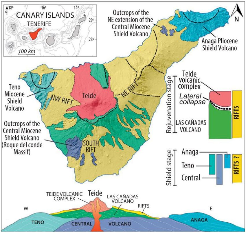
S. Leyva et al.

1 Introduction                                                      et al. 2008). Furthermore, evidence of the major influence
                                                                    of rain was provided in the previous study developed in the
Rockfalls are, by definition, a type of landslide involving         island of Tenerife by Jiménez and García-Fernández (2000).
abrupt downward movement of rock or soil, or both, that             The study concluded that there is a correlation, with more
detach from steep slopes or cliffs (Highland and Bobrowsky          than 99% certainty, between intense rainfall periods and the
2008). The falling mass may break on impact, start rolling          temporal distribution of local microearthquake activity in
on steeper slopes, and continue rolling until the terrain flat-     Tenerife.
tens. Rockfalls are frequent and damaging phenomena that               Moreover, climate change poses risks to human and natu-
occur on steep or vertical slopes, in coastal areas, mountains,     ral systems, and the processes of slope instabilities are part
and along rocky banks of rivers and streams (Langping and           of those risks (Komori et al. 2018; Lollino et al. 2015). The
Hengxing 2015). The volume of material in a rockfall can            result of climate change and global warming is less rainfall
vary considerably, from individual rocks or clumps of soil to       in annual rainfall count, but at the same time there are more
massive blocks thousands of cubic meters in size (Margottini        severe weather events that exceed precipitation thresholds
et al. 2013).                                                       and trigger slope movements, so there will be an increase in
   Water, whether it is solid water (ice, snow), whether it is      precipitation in concentrated events (Luo et al. 2017; Mateos
in liquid form such as rain, groundwater, melting ice, etc.;        et al. 2020). Although both factors have an influence, for
or whether it is water pressure, water energy (undercutting         triggering the mechanisms of soil and rock breakage that
of slopes by natural processes such as streams, rivers, and         move the material on the slopes, exceeding the precipitation
ocean/sea waves), seismic activity, or anthropogenic activi-        thresholds (punctual intense precipitation) is more important
ties (burst water pipes, and similar), etc., is the most com-       than the number of days of rainfall per year (accumulated
mon cause of rockfalls (Ansari et al. 2015; de Vallejo et al.       annual precipitation) (Bello-Rodríguez et al. 2019; Hendrix
2020a, b; Hibert et al. 2011; Hürlimann et al. 1999; Keefer         and Salehyan 2012; Hernández González et al. 2016; Her-
2002; Mateos et al. 2020; Saroglou 2019; Uchimura et al.            nandez et al. 2018).
2010; Wieczorek and Jäger 1996).                                       In order to define reliable thresholds for a certain area, we
   At regional scales, empirical approaches to forecast the         need to reconstruct the rockfall events and statistically ana-
occurrence of rainfall-induced landslides depend on accu-           lyze the historical rainfall conditions that caused landslides.
racy defining rainfall thresholds. In recent years, several         The data should serve as a guide for the possible prediction
authors have proposed different methods for calculating             of rainfall-induced rock slides.
rainfall thresholds through statistical analysis of empiri-            Rock curtains or other slope covers, protective covers
cal triggering rainfall distributions. These methods include        over roadways, retaining walls to prevent rolling or bouncing
cumulative rainfall amount versus rainfall duration, or aver-       are used to mitigate unstable slopes. Although rock bolts or
age rainfall intensity versus rainfall duration. However, these     other similar types of anchoring are used to stabilize cliffs,
precipitation thresholds include numerous uncertainties that        some landslides cannot be mitigated, making the importance
limit their application in early warning systems (Rosi et al.       of predicting failures even greater (Gutiérrez et al. 2010;
2020; Melillo et al. 2018; Guzzetti et al. 2020).                   Mateos et al. 2020). Primarily for the safety of the inhabit-
   The empirical estimation of precipitation thresholds is          ants but also for preserving infrastructures such as roads and
affected by different uncertainties linked to: (i) the availabil-   buildings. (Guzzetti et al. 2007, 2008; Miklin et al. 2016;
ity of quality information concerning rainfall measurements,        Peruccacci et al. 2017; Valenzuela et al. 2018, 2019; Ven-
with numerous parameters of intensity, duration, daily and          nari et al. 2014).
even hourly data; (ii) the existence of a good inventory of            When it comes to protecting human lives, there can
rockfalls that have occurred, specifically with the date of         never be sufficient research to ensure safety and prevent
their occurrence; (iii) the characterization and identifica-        catastrophic events. For Gran Canaria and Tenerife (Canary
tion of the rainfall event responsible for the landslide. For       Islands) a research group of the Research Institute for Geo-
this reason, it is difficult to find in the literature case stud-   hydrological Protection (IRPI) and the Geological Survey
ies with a good definition of the triggering rainfall thresh-       of Spain (IGME) analyzed rainfall-induced rockfalls based
olds. However, we can consider that rainfall is the factor          on CTRL-T algorithm exploiting continuous rainfall meas-
that most influences the instability of the slopes, and it can      urements, and landslide information (Melillo et al., 2020).
influence almost all the other water parameters mentioned           Therefore, in this article, we will show a new advance about
above (Ayonghe et al. 1999; Contino et al. 2017; Vessia et al.      correlation of rockfall and rainfall events from a historical-
2020). In addition, there is a great danger from rockfalls trig-    statistical perspective in the area of Anaga, Tenerife.
gered by rain, especially on volcanic, unstable slopes (Bar-
bano et al. 2014; Kimura and Kawabata 2015; Smerekanicz

13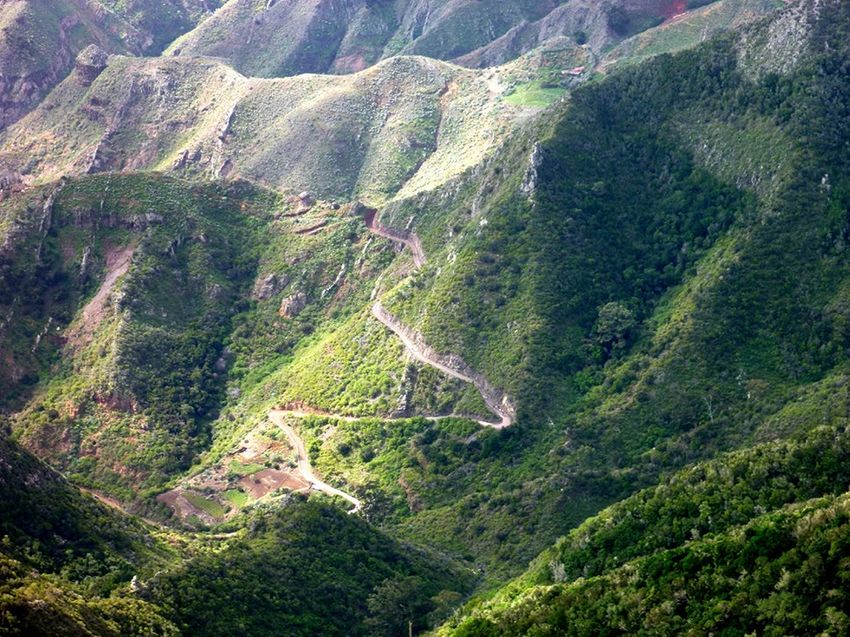
Rockfall and Rainfall Correlation in the Anaga Nature Reserve in Tenerife (Canary Islands,…
Fig. 1 Simplified geological
map and cross section of Tener-
ife showing the main structural
and geological units. Source:
Modified from (Troll and Car-
racedo 2016)
1.1 Study Area: Anaga, Tenerife (Canary Islands, million years ago and was followed by a period of dormancy.
Spain) Rejuvenation at approximately 3.5 Ma is recorded by the
central Las Cañadas volcano. During this period magmatic
The Canary archipelago in the Atlantic Ocean consists of differentiation processes occurred, leading to an episode of
eight islands with a total area of about 7500 km2. Tenerife felsic and highly explosive felsic volcanism (Fig. 1) (Martı́
is the largest (2057 k m2) and the most populated (966,000 and Wolff 2000; Troll and Carracedo 2016).
inhabitants and 13.2 million visitors in 2019) island in the The Anaga massif belongs to Series I (Middle–Upper
center of the Canary archipelago (Fig. 1) (data from the Miocene) and, due to erosion, this massif currently has a
Spanish National Statistical Institute). steep orography (Fig. 2) with steep slopes (Marinonia and
Tenerife not only occupies a central position within the Gudmundssonb 2000). The natural reserve of Anaga is
archipelago but also represents an intermediate evolutionary a protected area due to its richness in flora and fauna, as
stage relative to the eastern and the western islands of the well as archaeological sites (Jiménez-Gomis et al. 2019).
island chain. It is home to the third-largest volcano in the The orography and altitude favor rainfall in this area of the
world, Pico del Teide. If you take the seafloor as the base of island, a phenomenon that increases the probability of rock
the volcano and not the sea level, then the Teide rises more falls in Anaga (Fig. 3).
than 7000 m in height (3718 masl) (Melillo et al. 2020; Troll The Anaga massif has an average altitude of 850 m above
and Carracedo 2016). sea level and, in addition, a phenomenon known as the
Tenerife is mainly a basaltic shield, which represents “Foëhn effect” occurs here, which is produced by the warm,
about 90% of the volume of the island (Hürlimann et al. humid winds that blow frequently from the northwest to
1999). It lies on the Jurassic (150–170 Ma) oceanic litho- northeast, producing a layer of stratocumulus on the higher
sphere and was constructed via Miocene–Pliocene shields ground, often accompanied by drizzle (Santana 2014). Sub-
that now form the vertices of the island (Fullea et al. 2015). sequently, the air descends, losing its watery content on the
The shields were unified into a single edifice by later vol- opposite slope. This causes a constant humidity in Anaga,
canism that continued in central Tenerife from about 12 to 8 which leads to the capture of horizontal precipitation that
13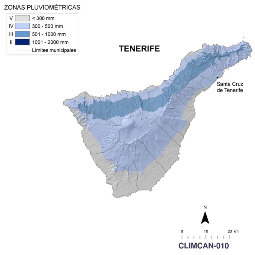
S. Leyva et al.
Island) (Fig. 1). In these locations the slopes dip at angles
ranging from 50° to 65° and from 26° to 30° and are nearly
vertical in the cliff areas. Most of these areas are the result of
earlier landslides and consequently, there is an early occur-
rence of large mass wasting processes (González de Vallejo
et al. 2008; Ledo et al. 2015). The accumulation of volcanic
lava flows and interbedded pyroclastic layers is the result of
cycles of continuous volcanic eruptions that can result in the
the build-up of large steeped edifices with poorly stabilized
slopes and high risk of landslides. The growth of such unsta-
ble volcanic edifices may occur over previously collapsed
areas, filling the resulting deeply eroded depressions prone
landslides. Steep slopes created by the accumulation of lavas
and pyroclasts are thought to be zones of potential landslide
hazard. An example of these steep areas is the “Teide stra-
Fig. 2 Steep orography of the Anaga Massif, Tenerife. Source: Juan tovolcano”, whose flank inclination varies from 25° to 30°.
C. Santamarta Teide has slopes higher than 1000 m and conditions close
to the limit where the slope gradient exceeds the friction
angle of their rock massifs (del Potro and Hürlimann 2008;
produces the Foëhn phenomenon (Kalivodová et al. 2020). Martı́ and Wolff 2000; Rodríguez-Losada et al. 2009). These
Therefore, the geographical situation of Anaga, located in areas can be prone to extremely large landslides if cohe-
the northeast of Tenerife, its altitude and the constant humid- sion decreases rapidly. The decrease can be due to shallow
ity on the slopes, make this area of Tenerife one of the areas magma injection, fluid injection, or groundwater pressure
with the highest rainfall compared to the rest of the island (Herrera and Custodio 2014; Kimura and Kawabata 2015;
(Diez-Sierra and del Jesus 2020). Rodríguez-Losada et al. 2009). Additional factors such as
High gradient slopes spread over large areas of the pre-existing fracture zones also increase the risk of land-
islands, and two antagonistic processes are involved in their slides (Hibert et al. 2011).
formation, namely erosion and the formation of lavas, scoria, The steep orography and climatic diversity of Tenerife
and pyroclastic layers. Erosion or mass wasting processes have resulted in a variety of landscapes and geographical
occur on previously unstable slopes. Thus, the northern part formations. The climate of Tenerife is subtropical oceanic;
of the island is characterized by narrow and deep ravines the minimum and maximum annual average temperatures
that contribute to intense slope activity (del Potro and Hür- are about 15 °C in winter and 24 °C in summer. The annual
limann 2008; Melillo et al. 2020). Usually, these landscapes rainfall ranges from 100 to 900 mm, being the northern
are associated with the oldest basaltic outcrops of the islands slope the one that receives the highest volume of rainfall,
(along the deep ravines and coastal cliffs of the “Anaga” and as can be seen from the following image taken from the
“Teno” massifs, the wall of the “Cañadas” caldera, head and document CLIMCAN-010 of the Government of the Canary
edges of the “Güimar” and “La Orotava” valleys in Tenerife Islands (Fig. 4). Besides, Tenerife offers a wide variety of
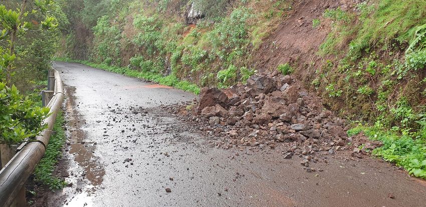
Fig. 3 Rockslides after rainfall
episodes affecting roads in
Anaga, Tenerife. Source: Juan
C. Santamarta
13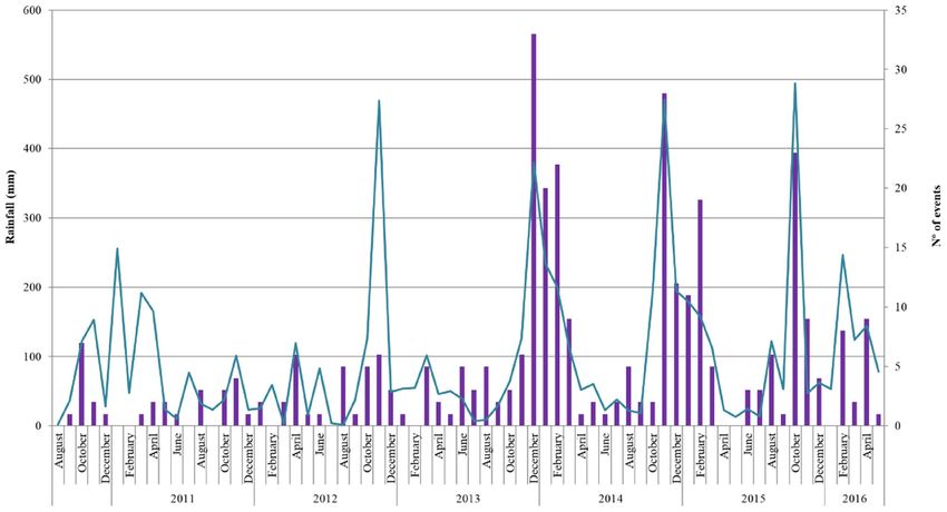
Rockfall and Rainfall Correlation in the Anaga Nature Reserve in Tenerife (Canary Islands,…

Fig. 4  Climatic charac-
terization of the Canary
Islands for the application
of the Technical Building
Code. Source:Government
of the Canary Islands
(CLIMCAN-010)

microclimates controlled by altitude and winds (Bechtel                        Table 1  Total kilometers of road in the island of Tenerife
2016; Hernández González et al. 2016; Köhler et al. 2006).                     Zone                                   Km                     % of total

                                                                               Ordinary maintenance
                                                                                 North                                  361                  26.18%
2 Methodology                                                                   South                                  250                  18.13%
                                                                                 Center                                 183                  13,31%
The methodology followed for data collection was:                              Integral conservation
                                                                                 Anaga                                  96                   6.98%
1. Collec data on all events classified as “Rockfalls” that                      West                                   97                   7.02%
   occurred during the period 2010–2016 (specifically from                       North                                 183                   13.26%
   01/08/2010 to 05/05/2016) that were addressed by the                          South                                 208                   15.13%
   personnel assigned to the Contracts of Integral Conser-                                                            1378                   100%
   vation of Roads (North, South, West and Anaga Sec-
   tors), promoted by the Cabildo Insular de Tenerife and
   conducted by external companies. This information was                          mated total of 1378 kms that in that period were avail-
   compiled from the management system implemented                                able in the entire island (Table 1). However, all the most
   in the Organic Unit of Integral Conservation (Cabildo                          important main roads of the island (highways, multi-lane
   de Tenerife), through the computer application GCC.2                           roads and conventional roads with the highest traffic) are
   “Gestor de Conservación de Carreteras Versión 2”.                              included; thus, their representativeness of the island's
2. The representativeness of the data in relation to the total-                   road infrastructure is considered as sufficient.
   ity of the administered roads (Insular and of Regional                      3. Review of all the reports of incidents collected, checking
   Interest), a total of 584 kms was included out of the esti-                    through the attached graphic information for possible

                                                                                                                                             13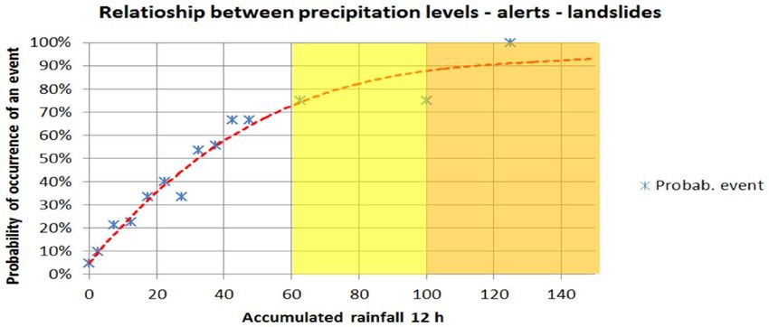
S. Leyva et al.
up to a maximum of 3 days before the event. The results
indicate:
• 39% of the maximum precipitation took place on the day
of the landslide;
• 26% the day before;
• 15% two days before;
• 20% three days before.
Therefore, only 40% of the events seem to be associated
with the maximum precipitation occurring on the day of
the landslide. This fact corroborates the experience in this
Sector, which confirms that after an episode of rainfall of a
certain intensity, events tend to occur not only on the same
day but also on the following days without new rainfall in
Fig. 5 Probability of an event occurring in Anaga as a function of
most cases.
daily precipitation level together with the corresponding mean and
extreme values considering N = 4, 3, 2 and 1 day. Source: (González Figure 6 shows the total number of events in Anaga and
de Vallejo et al. 2020a, b) the monthly accumulated rainfall. Thus, the results highlight
the direct relationship between the number of events and the
total amount of rainfall in that period.
errors, as well as the magnitude of the event, discarding The implications of this study can be used in emergency
for the study those related to very small surface detach- prevention management, especially for road maintenance
ments and with no effect on traffic. services, so that they can be on alert or mobilize the neces-
4. Compilation of all meteorological data during that sary resources in advance depending on the intensity of the
period (2010–2016) from all existing raingauges in the expected rainfall. In this sense, a graph (Fig. 7) has been
study area. The information published by AEMET1 and prepared for the Anaga Sector, which relates the level of
AgroCabildo2 was used, selecting the gauge closest to expected rainfall—type of alert with the probability of at
each incident. least one event occurring on that day. The alert system
5. Study the relationship between events and precipita- is similar to the meteorological alert system used by the
tion by calculating probabilities. In the case of Anaga AEMET (yellow, orange and red levels whose thresholds
Sector, due to previous experience, it was known that for Tenerife are 60/100/180 mm in 12 h), with the following
there was a certain delay between the day on which the results:
precipitation occurred and the day on which the event
occurred. Therefore, the study was done by checking the • A yellow alert (or pre-alert situation according to the
maximum daily precipitation, not only on the day of the DGSE of the Government of the Canary Islands) indi-
event, but up to 3 days before. cates the probability of at least one event occurring in the
Anaga Sector ranges between 70 and 90%.
• An orange alert indicates a probability ranging between
70 and 90%.
• A red alert indicates a probability of 100%.
3 Results and Discussion
Figure 5 shows the summary graph of the statistical study 4 Conclusions
conducted on the relationship between the daily level of
precipitation and landslide events occurring on the roads Intense rainfall modifies hydrogeological conditions and
of the Anaga Sector. water levels. Surface movements, predominantly of soils
A significant observation is the delay between the day of and altered materials, can be triggered. These movements
the event and the day the maximum precipitation occurred, can include new landslides or debris flows, reactivation of
old landslides and rockfalls.
From the analysis of the data, it can be concluded that
there is a direct relationship between accumulated rainfall
1
http://www.aemet.es/es/portada. and the occurrence of instabilities. The greatest probability
2
http://www.agrocabildo.org/agrometeorologia_estaciones.asp. for these events applies to when precipitation is greatest.
13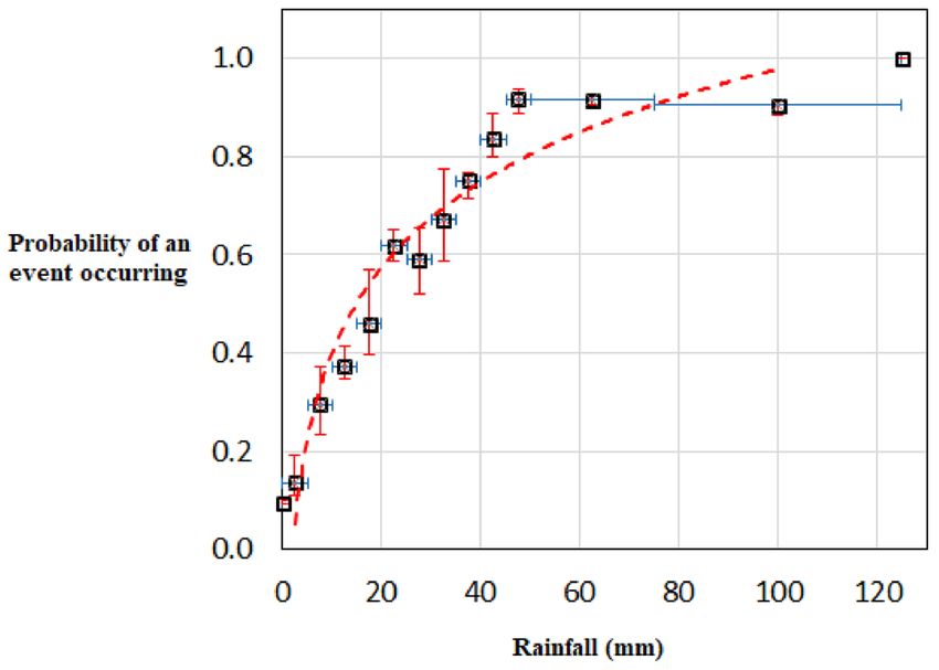
Rockfall and Rainfall Correlation in the Anaga Nature Reserve in Tenerife (Canary Islands,…

Fig. 6  Number of events related to rainfall events in the Anaga Sector. Observations taken from August 2010 to May 2016. Source:
MACASTAB project (González de Vallejo et al. 2020a, b)

Fig. 7  Relationship between
precipitation levels, alerts and
landslides in the Anaga sector

This relationship can be uses as a predictive tool in emer-                    and for events assessed by the Unit. Other events may have
gency management, especially for road maintenance and                          occurred in this area but may not have affected a road or may
conservation service. Likewise, it has been possible to verify                 not have been assessed by the Unit. Therefore, the values
in a certain Sector that in a relevant percentage, the events                  obtained should be considered as a minimum threshold.
do not occur in a rhythmic manner on the same day that the
maximum rainfall occurs but until several days later. This                     Acknowledgements The authors thank the Technical Service of Roads
                                                                               and Landscape of the Island Council of Tenerife for the information
circumstance is related to the geomorphology (steep reliefs)                   and documentation considered in this study. This work has been carried
and the type of material (strongly altered and weathered on                    out with the financial support of the Interreg Atlantic Area Programme
the surface) that makes up the slopes in Anaga area.                           through the European Regional Development Fund under grant agree-
   Finally, it should be noted that this study has been based                  ment N° EAPA_884/2018 (AGEO project). This contribution reflects
                                                                               only the authors’ view and that the European Union is not liable for any
on data provided by the Road Conservation Organic Unit.                        use that may be made of the information contained therein. Likewise,
These data apply only to landslides and rockfalls that occur                   we would like to thank the previous work developed by the technical
from slopes adjacent to roads the Unit is responsible for                      team drafting the MACASTAB Project as well as the University of La

                                                                                                                                          13
S. Leyva et al.
Laguna for their contribution in relation to the statistical treatment of González de Vallejo LI, Hijazo T, Ferrer M (2008) Engineering geo-
rainfall and event data. logical properties of the volcanic rocks and soils of the Canary
Islands. Soils Rocks 31(1):3–13
Funding Open Access funding provided thanks to the CRUE-CSIC González de Vallejo LI, Hernández-Gutiérrez LE, Miranda A, Fer-
agreement with Springer Nature. rer M (2020a) Rockfall hazard assessment in volcanic regions T.
Geosciences (Switzerland) 10(6):1–20. https://doi.org/10.3390/
geosciences10060220
Open Access This article is licensed under a Creative Commons Attri-
González de Vallejo LI, Hernández Gutiérrez LE, Miranda A, Ferrer
bution 4.0 International License, which permits use, sharing, adapta-
M (2020b) Rockfall hazard assessment in volcanic regions based
tion, distribution and reproduction in any medium or format, as long
on ISVS and IRVS geomechanical indices. Geosciences 10:1–20.
as you give appropriate credit to the original author(s) and the source,
https://doi.org/10.3390/geosciences10060220
provide a link to the Creative Commons licence, and indicate if changes
Gutiérrez F, Lucha P, Galve JP (2010) Reconstructing the geochrono-
were made. The images or other third party material in this article are
logical evolution of large landslides by means of the trenching
included in the article's Creative Commons licence, unless indicated
technique in the Yesa Reservoir ( Spanish Pyrenees ). Geomor-
otherwise in a credit line to the material. If material is not included in
phology 124(3–4):124–136. https://doi.org/10.1016/j.geomorph.
the article's Creative Commons licence and your intended use is not
2010.04.015
permitted by statutory regulation or exceeds the permitted use, you will
Guzzetti F, Rossi M, Nazionale C, Alta M, Stark CP (2007) Rainfall
need to obtain permission directly from the copyright holder. To view a
thresholds for the initiation of landslides in Central and South-
copy of this licence, visit http://creativecommons.org/licenses/by/4.0/.
ern Europe. Meteorol Atmos Phys. https://d oi.o rg/1 0.1 007/
s00703-007-0262-7
Guzzetti F, Peruccacci S, Rossi M, Stark CP (2008) The rainfall inten-
sity—duration control of shallow landslides and debris flows: an
References update. Landslides. https://doi.org/10.1007/s10346-007-0112-1
Guzzetti F, Luigi Gariano S, Peruccacci S, Brunetti M, Marchesini I,
Ansari MK, Ahmed M, Singh R, Singh TN, Ghalayani I (2015) Rain- Rossi M, Melillo M (2020) Geographical landslide early warn-
fall, a major cause for rockfall hazard along the roadways, high- ing systems. Earth Sci Rev 200:102973. https://d oi.o rg/1 0.1016/j.
ways and railways on Hilly Terrains in India. In: Lollino G, Man- earscirev.2019.102973
coni A, Clague J, Shan W, Chiarle M (eds) Engineering geology Hendrix CS, Salehyan I (2012) Climate change, rainfall, and social
for society and territory, 1. Springer, Cham, pp 457–460. https:// conflict in Africa. J Peace Res 49(1):35–50. https://doi.org/10.
doi.org/10.1007/978-3-319-09300-0 1177/0022343311426165
Ayonghe SN, Mafany GT, Ntasin E, Samalang P (1999) Seismically Hernandez Y, Guimarães Pereira Â, Barbosa P (2018) Resilient futures
activated swarm of landslides, tension cracks, and a rockfall after of a small island: a participatory approach in Tenerife (Canary
heavy rainfall in Bafaka, Cameroon. Nat Hazards 19(1):13–27. Islands) to address climate change. Environ Sci Policy 80(Novem-
https://doi.org/10.1023/A:1008041205256 ber 2017):28–37. https://doi.org/10.1016/j.envsci.2017.11.008
Barbano MS, Pappalardo G, Pirrotta C, Mineo S (2014) Landslide Hernández González Y, Gimaraes-Pereira Â, Rodríguez González S,
triggers along volcanic rock slopes in eastern Sicily (Italy). Cuevas Agulló E, Barbosa P (2016) Perspectives on contentions
Nat Hazards 73(3):1587–1607. https:// d oi. o rg/ 1 0. 1 007/ about climate change adaptation in the Canary Islands: a case
s11069-014-1160-1 study for Tenerife. European Commission, Joint Research Centre
Bechtel B (2016) The climate of the canary Islands by annual Publications Office. https://data.europa.eu/doi/10.2788/8586
cycle parameters. Int Arch Photogramm Remote Sens Spa- Herrera C, Custodio E (2014) Groundwater flow in a relatively old
tial Inf Sci 41:243–250. https:// d oi. o rg/ 1 0. 5 194/ i sprs a rchi oceanic volcanic island: the Betancuria area, Fuerteventura Island,
ves-XLI-B8-243-2016 Canary Islands, Spain. Sci Total Environ 496:531–550. https://d oi.
Bello-Rodríguez V, Gómez LA, Fernández López Á, Del-Arco-Aguilar org/10.1016/j.scitotenv.2014.07.063
MJ, Hernández-Hernández R, Emerson B, González-Mancebo JM Hibert C, Mangeney A, Grandjean G, Shapiro NM (2011) Slope insta-
(2019) Short- and long-term effects of fire in subtropical cloud bilities in Dolomieu crater, Réunion Island: from seismic signals
forests on an oceanic island. Land Degrad Dev 30(4):448–458. to rockfall characteristics. J Geophys Res Earth Surf 116(4):1–18.
https://doi.org/10.1002/ldr.3237 https://doi.org/10.1029/2011JF002038
Contino A, Bova P, Esposito G, Giuffré I, Monteleone S (2017) Histori- Highland LM, Bobrowsky P (2008) The landslide handbook—a
cal analysis of rainfall-triggered rockfalls: the case study of the guide to understanding landslides. US Geol Surv Circ 1325:1–
disaster of the ancient hydrothermal Sclafani Spa (Madonie Mts, 147. https://doi.org/10.3133/cir1325
northern-central Sicily, Italy) in 1851. Nat Hazards Earth Syst Sci Hürlimann M, Ledesma A, Martí J (1999) Conditions favouring cata-
17(12):2229–2243. https://doi.org/10.5194/nhess-17-2229-2017 strophic landslides on Tenerife (Canary Islands). Terra Nova
del Potro R, Hürlimann M (2008) Geotechnical classification and char- 11(2–3):106–111. https://doi.org/10.1046/j.1365-3121.1999.
acterisation of materials for stability analyses of large volcanic 00233.x
slopes. Eng Geol 98(1–2):1–17. https://doi.org/10.1016/j.enggeo. Jiménez MJ, García-Fernández M (2000) Occurence of shallow
2007.11.007 earthquakes following periods of intense rainfall in Tenerife,
Diez-Sierra J, del Jesus M (2020) Long-term rainfall prediction using Canary Islands. J Volcanol Geotherm Res 103(1–4):463–468.
atmospheric synoptic patterns in semi-arid climates with statisti- https://doi.org/10.1016/S0377-0273(00)00237-7
cal and machine learning methods. J Hydrol 586:124789. https:// Jiménez-Gomis C, García Frank A, Sarmiento Chiesa G, Castillo
doi.org/10.1016/j.jhydrol.2020.124789 Ruiz C (2019) Conservation status of the listed marine fos-
Fullea J, Camacho AG, Negredo AM, Fernández J (2015) The Canary sil sites in the Macizo de Anaga biosphere reserve (Tenerife,
Islands hot spot: new insights from 3D coupled geophysical- Canary Islands, Spain). Geoheritage 11(4):1757–1769. https://
petrological modelling of the lithosphere and uppermost mantle. doi.org/10.1007/s12371-019-00388-9
Earth Planet Sci Lett 409:71–88. https://doi.org/10.1016/j.epsl. Kalivodová H, Culek M, Čermák M, Maděra P, Habrová H (2020)
2014.10.038 Potential importance of Socotra dragon’s blood tree cloud
forests and woodlands for capturing horizontal precipitation.
13Rockfall and Rainfall Correlation in the Anaga Nature Reserve in Tenerife (Canary Islands,…
Rendiconti Lincei 31(3):607–621. https://d oi.o rg/1 0.1 007/ Italy. Geomorphology 290:39–57. https://d oi.o rg/1 0.1 016/j.g eomo
s12210-020-00933-7 rph.2017.03.031
Keefer DK (2002). Investigating landslides caused by earthquakes— Rodríguez-Losada JA, Hernández-Gutiérrez LE, Olalla C, Perucho A,
a historical review. U.S. Geological Survey, 345 Middlefield Serrano A, Eff-Darwich A (2009) Geomechanical parameters of
Road MS 977, Menlo Park, CA 94025, USA, 473–510 intact rocks and rock masses from the Canary Islands: implica-
Kimura J-I, Kawabata H (2015) Geochemistry, geophysics, geosys- tions on their flank stability. J Volcanol Geotherm Res 182(1–
tems. Geochem Geophys Geosyst 16(1):267–300. https://doi. 2):67–75. https://doi.org/10.1016/j.jvolgeores.2009.01.032
org/10.1002/2014GC005684.Key Rosi A, Segoni S, Canavesi V, Monni A, Gallucci A, Casagli N (2020)
Köhler L, Gieger T, Leuschner C (2006) Altitudinal change in soil Definition of 3D rainfall thresholds to increase operative landslide
and foliar nutrient concentrations and in microclimate across the early warning system performances. Landslides 18(3):1045–1057.
tree line on the subtropical island mountain Mt. Teide (Canary https://doi.org/10.1007/s10346-020-01523-2
Islands). Flora: Morphol Distrib Funct Ecol Plant 201(3):202– Santana LM (2014) Estudio climático sucinto de anaga. Cabildo de
214. https://doi.org/10.1016/j.flora.2005.07.003 Tenerife. https://www.agrocabildo.org/publica/analisisclimatico/
Komori D, Rangsiwanichpong P, Inoue N, Ono K (2018) Climate ANAGA_SUCINTO.pdf
risk management distributed probability of slope failure in Saroglou C (2019) GIS-based rockfall susceptibility zoning in Greece.
Thailand under climate change. Clim Risk Manag 20(October Geosciences (Switzerland). https://doi.org/10.3390/geoscience
2017):126–137. https://doi.org/10.1016/j.crm.2018.03.002 s9040163
Langping Li, Hengxing L (2015) Probabilistic modeling of rockfall Smerekanicz J, Peter C, Ingraham P, Brandon H, Hee P, Ferdinand M,
trajectories: a review. Bull Eng Geol Environ 74:1163–1176. Cajigal P, Journeaux D (2008) Rock slope stabilization measures
https://doi.org/10.1007/s10064-015-0718-9 at the Pali tunnel route 30, Maui, Hawai’i. In: 58 th Highway
Ledo J, Queralt P, Marcuello A, Bellmunt F, Ogaya X, Pérez N Geology Symposium (HGS) [online]. Santa Fe: New Mexico
(2015) Vertical collapse origin of Las Cañadas caldera (Ten- Department of Transportation & New Mexico Bureau of Geol-
erife, Canary Islands) revealed by 3-D magnetotelluric inver- ogy and Mineral Resources, pp 142–153. http://w ww.h ighwa ygeo
sion. Geophys Res Lett 42:1710–1716. https://doi.org/10.1002/ logysymposium.org/wp-content/uploads/59_HGS-r-OPT.pdf
2015GL063042.Received Troll VR, Carracedo JC (2016) The geology of tenerife 5. Elsevier,
Lollino G, Manconi A, Clague J, Shan W, Chiarle M (2015) Engi- Amsterdam. https:// d oi. o rg/ 1 0. 1 016/ B 978-0- 1 2- 8 09663- 5 .
neering geology for society and territory (Climate Ch, Vol. 1). 00005-0
Springer International Publishing, Switzerland Uchimura T, Towhata I, Anh TTL, Fukuda J, Bautista CJB, Wang
Luo J, Zheng Z, Li T, He S (2017) Spatial heterogeneity of micro- L, Seko I, Uchida T, Matsuoka A, Ito Y, Onda Y, Iwagami S,
topography and its influence on the flow convergence of slopes Kim MS, Sakai N (2010) Simple monitoring method for precau-
under different rainfall patterns. J Hydrol 545:88–99. https:// tion of landslides watching tilting and water contents on slopes
doi.org/10.1016/j.jhydrol.2016.12.018 surface. Landslides 7(3):351–357. https:// d oi. o rg/ 1 0. 1 007/
Margottini C, Canuti P, Sassa K (2013) Landslide science and prac- s10346-009-0178-z
tice, vol 1. Springer, Heidelberg, New York, Dordrecht, London. Valenzuela P, José IM, Antonio DIM, García M (2018) Rainfall thresh-
https://doi.org/10.1007/978-3-642-31325-7 olds for the triggering of landslides considering previous soil
Marinonia LB, Gudmundssonb A (2000) Dykes, faults and palae- moisture conditions ( Asturias, NW Spain). Landslides. https://
ostresses in the Teno and Anaga massifs of Tenerife (Canary doi.org/10.1007/s10346-017-0878-8
Islands). J Volcanol Geotherm Res 103:83–103. https://doi.org/ Valenzuela P, Zêzere JL, Domínguez-cuesta MJ, Antonio M, García
10.1016/S0377-0273(00)00217-1 M (2019) Empirical rainfall thresholds for the triggering of land-
Martı́ J, Wolff JA (2000) Introduction: the geology and geophysics slides in Asturias (NW Spain). Landslides 16:1285–1300. https://
of Tenerife. J Volcanol Geotherm Res 103(1–4):7–10. https:// doi.org/10.1007/s10346-019-01170-2
doi.org/10.1016/s0377-0273(00)00213-4 Vennari C, Gariano SL, Antronico L, Brunetti MT, Iovine G, Peruc-
Mateos RM, López-Vinielles J, Poyiadji E, Tsagkas D, Sheehy M, Had- cacci S, Terranova O, Irpi CNR, Alta M, Università P (2014)
jicharalambous K, Liscák P, Podolski L, Laskowicz I, Iadanza Rainfall thresholds for shallow landslide occurrence in Calabria,
C, Gauert C, Todorović S, Auflič MJ, Maftei R, Hermanns RL, southern Italy. Nat Hazards Earth Syst Sci 14:317–330. https://
Kociu A, Sandić C, Mauter R, Sarro R et al (2020) Integration of doi.org/10.5194/nhess-14-317-2014
landslide hazard into urban planning across Europe. Landsc Urban Vessia G, Di Curzio D, Chiaudani A, Rusi S (2020) Regional rainfall
Plan. https://doi.org/10.1016/j.landurbplan.2019.103740 threshold maps drawn through multivariate geostatistical tech-
Melillo M, Brunetti M, Peruccacci S, Gariano S, Roccati A, Guzzetti F niques for shallow landslide hazard zonation. Sci Total Environ
(2018) A tool for the automatic calculation of rainfall thresholds 705:135815. https://doi.org/10.1016/j.scitotenv.2019.135815
for landslide occurrence. Environ Model Softw 105:230–243. Wieczorek GF, Jäger S (1996) Triggering mechanisms and depositional
https://doi.org/10.1016/j.envsoft.2018.03.024 rates of postglacial slope- movement processes in the Yosemite
Melillo M, Gariano SL, Peruccacci S, Sarro R, Mateos RM, Brunetti Valley, California. Geomorphology 15:17–31. https://doi.org/10.
MT (2020) Rainfall and rockfalls in the Canary Islands: assessing 1016/0169-555X(95)00112-I
a seasonal link. Nat Hazards Earth Syst Sci 20(8):2307–2317.
https://doi.org/10.5194/nhess-20-2307-2020 Publisher's Note Springer Nature remains neutral with regard to
Miklin Ž, Urumović K, Terzić J, Halamić J, Novosel T (2016) Engi- jurisdictional claims in published maps and institutional affiliations.
neering geological model of landslide Dragodan. Zbornik Na
Trudovi - Knjiga 1. In: Lepitkova S, Boev B (eds) Struga : Make-
donsko Geološko Društvo, pp 229–237. https://www.bib.irb.hr/
857775
Peruccacci S, Brunetti MT, Gariano SL, Melillo M (2017) Geomor-
phology rainfall thresholds for possible landslide occurrence in
13You can also read