S1 MOBILE MAPPER APPLICATION for Android - Field User Training 2023 ORWA Mobile Team
←
→
Page content transcription
If your browser does not render page correctly, please read the page content below
S1 MOBILE MAPPER APPLICATION for Android
     Field User Training 2023
     ORWA Mobile Team
                                           1
Training & Field Data Collection Outline
Introduction: Name and Location
Exercise 1: Device Set Up and AGOL Group Membership
Exercise 2: Download Basemaps
Exercise 3: Download Web Map Data
Outside Demo: Create New Features (GPS & Digitize)-Virtual class
Exercise 4: Create New Features (student hands-on time)
Lunch: 12:15pm – 1:00pm
Exercise 5: Sync Collected Data and Interact with it in AGOL
Discussion & Demo: ArcGIS Online (AGOL)-quick overview
Instructor Q&A: Follow Up Discussions, Where to Find Help, & the Training Survey2
The S1 Mobile Mapper GIS Program Mission:

  • To create an easy to use, integrated Mobile GIS data collection platform.

  • To support agency personnel in facilitating viewing, capturing and editing of
    geospatial resource data.

  • To use Modern mobile devices in a Disconnected network environment.

                                  Oregon/Washington BLM

                                                                                    3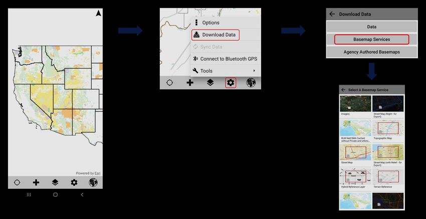
S1 Mobile Mapper App Overview
• ArcGIS Online (AGOL) for Organizations account access is the backbone of data collection
  •   S1 Mobile Mapper App and other mobile data collection apps.
  •   Internet access: Download data and sync collected data back to AGOL.

• Offline workflows for field data collection (no internet connection).
  •   Collect points, line and polygons in the field and add attribute information.

• Downloads, Displays, and Advantages:
  •   Supports a variety of basemap file types: .tpk, .tpkx, .vtpk and GeoTiff.
  •   Supports many basemap downloads (only limited by storage space) in addition to the Default basemap.
  •   Supports managing S1 content on the mobile device.
  •   S1 Mobile Mapper has some advanced tools: Nested features, buffer, navigation tools, etc.
  •   Hosted or On-Premise Feature Services, Web Maps and Mobile Map Packages (.mmpk are read only).
  •   Supports some Field Maps smart forms functionality, for example, conditional statements using Arcade expressions, attribute field grouping, and
      subtitle text.
  •   Advantage: Custom workflows to edit corporate themes with QA/QC capability (Sync & Submit).
  • Advantage: In-house app customization-Driven by S1 Mobile Mapper Feedback & Ideas Page submitted by app users. This allows flexible content
    management that can address user issues quickly.
  • Advantage: Ad Hoc data collection options (allows for unplanned data capture): Waypoints, Tracklogs, GeoTagged Photos, Sketches

                                                                                                                                                        5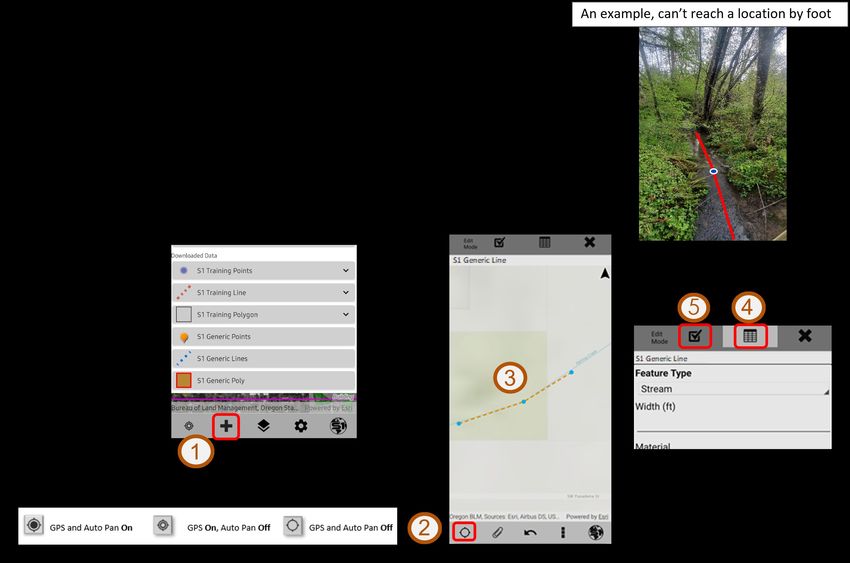
Common Terms to Know
Feature Class (ArcGIS Pro)
        •   Same spatial representation, such as all points, lines, or polygons. For example, “a
            feature class of points or a feature class of polygons”.
        •   Each feature class has its own set of attribute columns.

Feature Service - or Feature Layer (Hosted) Service (AGOL)
        •   Essentially this is the “editable data” available in the S1 Mobile Mapper app. Can be a
            standalone service or be included within a web map.
        •   Makes your data available for use in web clients, desktop apps, and field apps. Hosted
            on AGOL.
Layer
        •   Visual representation of a geographic dataset in any digital map environment.
            Examples: imagery layer (basemap), a point feature class layer, hosted web map layer,
            tile layer, etc.
Basemap
        •   Serves as a bottom reference map. The S1 Mobile Mapper app allows users to layer
            basemaps on top of each other with on-the-fly transparency adjustment functionality.
        •   Can be created by users as a TPK, TPKX, VTPK or GeoTiff file (published from ArcMap or
            ArcGIS Pro).
        •   Basemaps are the foundation for your maps and provide context for your work.
Web Map
    •   Online maps created with ArcGIS Online, published from ArcMap or ArcGIS Pro, that
        provide a way to work and interact with geographic content organized as layers.
        •   Shared on the web and across smartphones and tablets. Each web map contains a
            basemap along with a set of additional data layers.
                                                                                                      6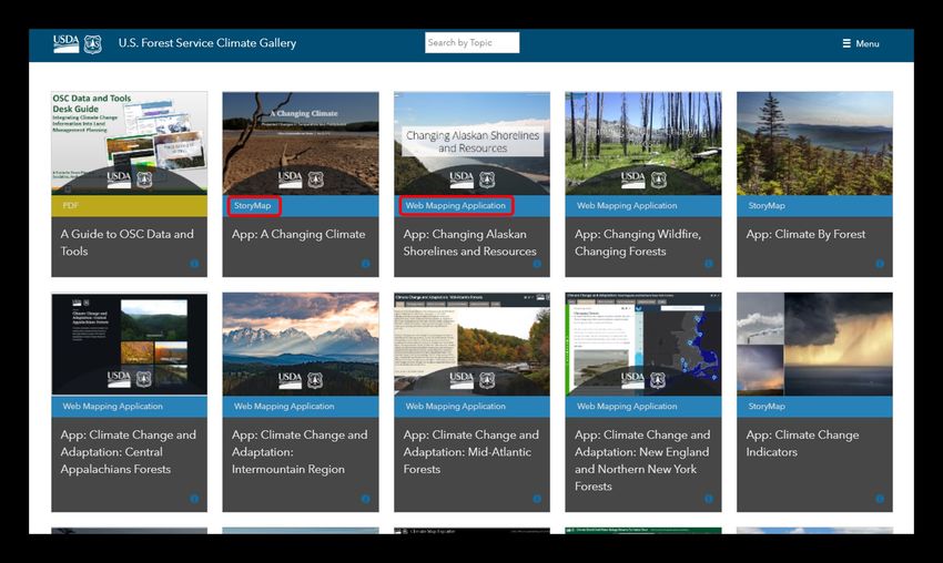
How we use ArcGIS Online (AGOL)

                                  7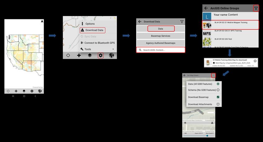
Hosted Feature Service -vs- S1 Ad-Hoc Options
Concept: Publish a hosted service that covers any potential basic data capture types, and always keep a copy on the mobile
device for unforeseen data collection needs. Essentially, a hosted service instead with one button sync and immediate
availability and access vs using Ad-Hoc data collection and manual process to get into GIS.

                                                                                                                     8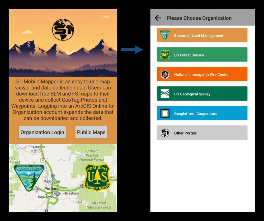
Where to Find Information

https://www.blm.gov/services/geospatial/
mobile-GIS/s1mobile

   S1 Mobile Mapper Agency
    User Guide download in
      the App-Help Button
                                           9
BREAK TIME
 (10 MINS)
 Back @ 9:25am
S1 Mobile Mapper Workflow – Downloads and Field Data Collections
After device setup and creating services (Hosted on AGOL; web maps and feature layers, etc.)
1. Download and install the S1 Mobile Mapper app.
2. Download one or more basemaps or use the Default basemap.
3. Download data (internet service): download a feature service or a web map
(editable) to use in the field.
4. Collect data offline in the field via GPS or digitizing.
5. Useful tools in the S1 Mobile Mapper App.
6. Sync data back to ArcGIS Online (AGOL).
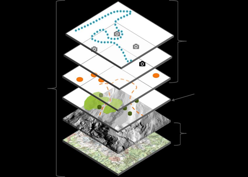
12S1 Mobile Mapper Layer Hierarchy & Key Concepts
Key S1 Concepts
• User can have multiple different editable databases
downloaded to the device (only limited by storage space).
• Only one editable database can be displayed in the active map view
at a time.
• Editable data in S1 can be either from standalone feature
service downloads or packaged with other feature services
via a web map (basemaps can also be downloaded with web
maps if desired).
• Every layer (ad-hoc data, editable services & basemaps) can
be toggled on/off or removed from the active map view as
needed.
• User can have as many basemaps downloaded as they like
(only limited by storage space)
• User can have as many basemaps layered in the active map
view as they like and can adjust the basemap layer order &
transparency as needed.
• The S1 Default basemap cannot be deleted from the device.
131. Exercise 1: Install & Confirm Login to the S1 Mobile Mapper Application
• Download S1 Mobile Mapper App v5.3.023
• Google Play Store
or
• Maas360 app catalog
• Confirm Login and Training Group Membership
with an ArcGIS Mobile Editor Account
Demo & Hands-on
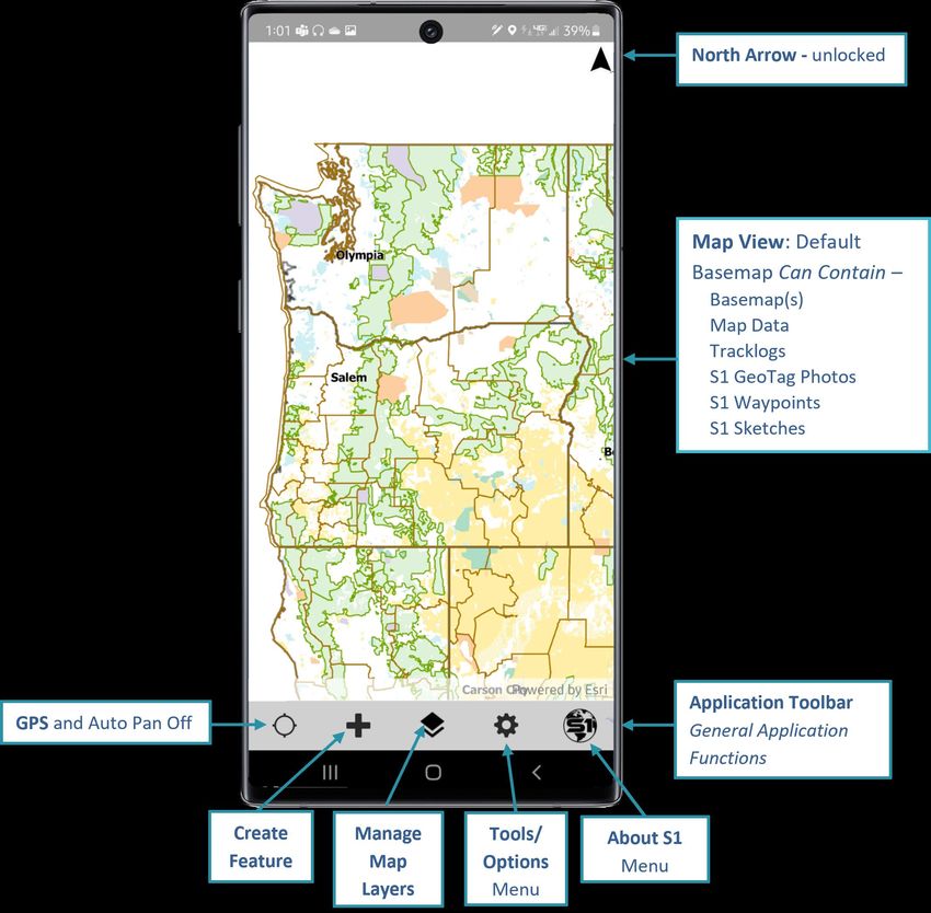
14The S1 Mobile Mapper Interface
152. Download One or More Basemaps
Note: Basemaps can also be
added as a Data download via
web map or from a .tpkx file.
16Exercise 2: Downloading and Managing Basemaps
30 minutes
Demo Hands-On:
• Download Agency basemap for user’s location.
• Download an ESRI Imagery basemap (Raster)
• Download Terrain with Labels (Vector Tile Package
.vtpk)
• Basemap UI - delete map , zoom to map, long
press to reorder, transparency and toggle on/off.
17Collect Feature via Digitizing - Interface
What is Digitizing?
• Digitizing is adding a new feature with the GPS Off. Essentially drawing a point, line or polygon on the map and
filling out the appropriate attributes.
When to Digitize?
• Poor satellite signal
• Can’t reach a location by foot
• Need to transcribe data from another format
How to digitize in the S1 Mobile Mapper app:
1. Select the Collect Feature button
2. Confirm that GPS is turned off
3. Tap on map to digitize feature
4. Edit the attribute table
5. Submit feature
18Select Mode - Interface
• Edit Feature > Edit Mode
• Manage Attachments
• Copy Geometry
• Delete Feature
• Navigate to Selected Feature
• Route to Selected Feature
• Feature Info Pop Up (blue bar & map popup)
• Tap blue bar
• Tap arrow to see features if multiple features are
selected
19Collect lines or polygons via either Streaming or Averaging
When to use one over the other?
• Speed vs. Accuracy
• Feature outline type
• Can Mix & Match Methods
Streaming; Captures vertices at a user defined Averaging; Uses a user defined number of
interval (time or distance) based on the GPS vertices to average a final location
information at the time “no averaging”. Better for coordinate. Best for features with straight
capturing data that does not have hard corners; trails, lines and hard corners; property
recreation areas, parking lots, etc. boundaries, building footprints, (inherently
more accurate than streaming).
203. Download Data in S1 Mobile Mapper
Exercise 3: Download a Web Map
• Download S1 Mobile Training (Web Map for
Download) for creating new features in the S1
Mobile Mapper app.
• Discussion includes filter, search, and download
options of basemaps with the web map.
21Managing Map Layers
22Before You Head Out Into the Field
Verify device is fully charged.
Verify that all maps and data have been
downloaded.
Test your dataset prior to first offline field visit.
Set device to airplane mode (conserve battery).
Set location to GPS ONLY.
Review S1 Option settings in office/in the field.
23BREAK TIME Back @
Demo: Collect Data Offline in the Field with GPS or Digitize
                                    Instructor Demo – Outside Virtual Training
•   Enable Tracklog
•   Configure S1 Options to improve GPS data collection.
•   Show the GPS on/off tool.
•   Collect a point (PT) feature via GPS Averaging.
•   Offset feature data collection.
•   Buffer features (existing feature & GPS location).
•   Collect a line (LN) feature via GPS Streaming/Averaging.
•   Nested Point data collection.
•   Collect a Polygon (PG) Feature via GPS Averaging/Streaming.
•   Add Photo Attachments
•   Interacting with map features – select existing features, edit attributes, and
    delete features.
•   Digitize a point and line (as appropriate).
•   Create an S1 Sketch
•   Navigate to a Map Target (discuss how this might be used to get distance and
    direction to or from a feature) azimuth/bearing etc.                             25
4. Collect Data Offline in the Field with GPS or Digitize
Student Hands-on Time
Enable Tracklogs
Configure S1 Options
Collect points via GPS Averaging
Offset feature data collection
Collect lines via Streaming/Averaging
Nest a point feature
Collect polygons via Streaming/Averaging
Collect Photo Attachments
Navigate to a Map Target
Play around with S1 tools and interface…..
26COLLECT DATA
&
LUNCH
Back @5. Useful Tools in the S1 Mobile Mapper App
Step-by-step directions for all S1 tools are in the Agency User Guide on the S1 Mobile
Mapper Website or can be downloaded from the Help option in the S1 Mobile Mapper App.
286. Sync Data Back to the Group in ArcGIS Online (AGOL)
Exercise 5: Sync Collected Data and Interact with that Data in AGOL
• Sync settings – Sync direction in the Options.
• Sync data back to the S1 Mobile Training (Web Map for download).
• Review how student data collection hands-on time went and answer any specific S1 data
collection questions.
• Access AGOL and explore the student’s synced data.
• Check out some other examples of Web Apps in AGOL and why they might be useful (Dashboard,
Attachment viewer, Web Scene and more).
29Demo ArcGIS Online
ArcGIS.com
• Brief ArcGIS Online overview of contents: Feature Services and Web Maps
• Demo the Training web map in Map Viewer
• ArcGIS Online training resources: -DOI Talent, ex. Online ArcGIS (AGOL) for GIS Professionals
-Esri Free Courses, ex. ArcGIS Online Basics web course
-S1 Mobile Mapper Training Exercises, Training Demo 1: Build in AGOLWeb App Examples for Inspiration
Story Maps integrates maps, legends, text, photos, and video and
The Northwest Huckleberry and Other Nuts provides functionality, such as swipe, pop-ups, and time sliders, that
and Berries of the Region – Story Maps helps users explore the story and content. Is a linear narrative. Story
Maps Tutorial
Web Mapping Applications (Web Apps) are more geared toward being
browsing and searching exploratory interfaces. Widgets allow you to
customize the WebApp to provide custom search, filter, and view options.
But the format is structured more as a dashboard than a linear narrative.
Web Apps Tutorial
U.S. Forest Service Climate Gallery BLM Public Web Apps
31Example Dashboards For Inspiration
ArcGIS Dashboards -authored in ArcGIS Online (AGOL)
• Enables users to convey information by presenting location-based analytics.
• Displays multiple, interactive visualizations that work together on a single screen.
• Allows you to monitor events, make decisions, inform others, and see trends.
• Insights for at-a-glance decision-making. Dashboard Tutorial
S1 Mobile Theme Sync and Submits 2021 Covid-19 Dashboard by the Center for Systems Science and
Number of S1 Mobile Versions Submitted by Theme and District Engineering (CSSE) at Johns Hopkins University (JHU)
32LIVE DEMO VIEW OF TRAINING DATA
SOME EXAMPLE LINKS OF WHAT CAN BE DONE WITH THE
DATA IN AGOL
• S1 Basic Web Map with training data
• S1 Attachment Viewer (Web App)
• S1 Training Data Dashboard (Web App)
• S1 3D Basic Scene Viewer (Not web app/no widgets)
• S1 3D Scene Viewer (Web App with Widgets)Service First (S1) Mobile Mapper Team
Russ Chapman (BLM) Lisa L. Silva (BLM Contractor)
S1 Mobile GIS Specialist S1 Mobile GIS Specialist (Training)
rchapman@blm.gov llsilva@blm.gov
Diego Galvan Meza (BLM Contractor) Lynn N. Nguyen (BLM Contractor)
New Developer New DevOps Project Manager
dgalvanmeza@blm.gov lnguyen@blm.gov
34MOBILE GIS SUPPORT (BLM)
Office Primary Contacts
Salem Andrew Jensen/Michelle Davis
Eugene Bernadette Hoffman
Roseburg Mike Hubbard/Kim Gray
Coos Bay Tristan Holland/John Guetterman
Medford ??/Steve Haney
Lakeview Shannon Theall
Klamath Falls Vacant?
Prineville Vacant?
Burns Linda Watts
Vale Marissa Russell
Spokane Pete Sargent
Grants Pass Shawn Thornton
Baker City Jeff Jager
Tillamook David Tyler
35ADDITIONAL RESOURCES
• S1 Mobile Website
• S1 User Guide
• S1 Mobile FAQ
• S1 Help Videos
36Tell Us What You Think
Please fill out the S1 Training Survey to help us continue
to improve S1 Mobile Mapping trainings moving forward.
3738
You can also read