Stage 2 Archaeological Assessment - ORINGIAL REPORT - City of Ottawa
←
→
Page content transcription
If your browser does not render page correctly, please read the page content below
ORINGIAL REPORT

Stage 2 Archaeological Assessment
Ottawa Hospital, Part of Lots I & K, Broken Front B, Geographic Township of
Nepean, City of Ottawa, Ontario

Licensee: Randy Hahn (P1107)

PIF Number: P1107-0041-2021

Submitted to:
Parsons Inc.
c/o Ronald Clarke MCIP, RPP
1223 Michael Street, Suite 100
Ottawa, Ontario
K1J 7T2

Submitted by:
Golder Associates Ltd.
1931 Robertson Road Ottawa, Ontario, K2H 5B7 Canada

+1 613 592 9600

1912764; 21451149

July 19, 2021
July 19, 2021                                                            1912764; 21451149

Distribution List
1 e-copy - Parsons Inc.

1 e-copy - Ministry of Heritage, Sport, Tourism and Culture Industries

1 e-copy - National Capital Commission

1 e-copy - Golder Associates Ltd.

                                                                                         i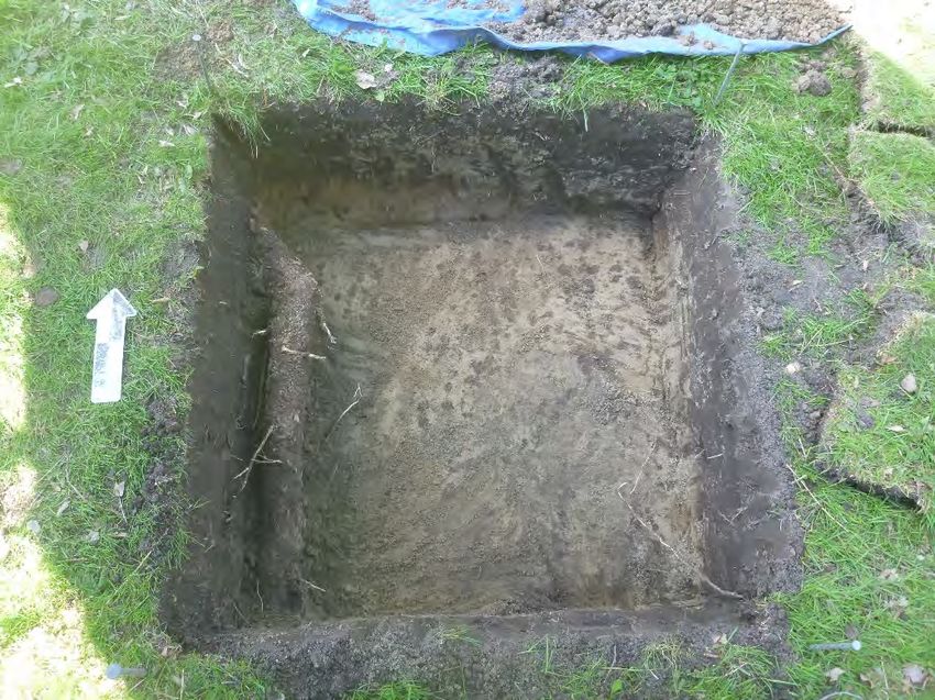
July 19, 2021                                                                                       1912764; 21451149

Executive Summary
The Executive Summary highlights key points from the report only; for complete information and findings, as well
as the limitations, the reader should examine the complete report.

Golder Associates Ltd. (Golder) was retained by Parsons Inc. (Parsons) on behalf of The Ottawa Hospital to
conduct a Stage 2 archaeological assessment for the proposed new hospital campus, referred to as the New
Civic Development, on federal land until recently within the Central Experimental Farm, part of lots I & K, Broken
Front B, geographic township of Nepean, City of Ottawa, Ontario (Maps 1 & 2). The study area is an
approximately 20.6 hectare portion of the property.

The objectives of this Stage 2 archaeological assessment are to document archaeological resources on the
property, to determine whether the property contains archaeological resources requiring further assessment, and
to recommend appropriate Stage 3 assessment strategies for any archaeological sites identified.

Evidence for human occupation of Eastern Ontario dates to at least 9,000 Before Present (BP) following the retreat
of the Champlain Sea. Based upon the existing data, the study area first became available for human occupation in
the late Paleo Period or very early in the Archaic Period and was subsequently occupied until contact with European
explorers. Nepean Township was first surveyed for settlement in the late 18th century. The construction of the
Rideau Canal between 1826 and 1832 brought in an influx of settlers to the township. The study area was
farmland by the mid-19th century with historical maps from 1863 and 1879 showing several structures located
along Prince of Wales Drive. In 1886, the study area became part of the Central Experimental Farm, a
government run farm dedicated to researching agricultural practice. During the 20th century, the study area
contained the Sir John Carling Building, the headquarters of Agriculture and Agri-Food Canada between 1967 and
2009. The Sir John Carling Building was demolished in 2014.

The Stage 2 archaeological assessment, consisting of a test pit survey at 5 m intervals, was completed in nine
days between May 4 and May 14, 2021. A total of 549 artifacts were recovered from 83 positive test pits. The
majority of artifacts date to the early to mid-20th century during the period when the land was part of the Central
Experimental Farm. One large scatter of artifacts is located in the vicinity of a 19th century farmstead depicted on
the 1879 map of Nepean Township. However, few artifacts in this area date to the 19th century and the
assemblage is characteristic of an early 20th century date. Therefore, none of the find spots associated with the
Stage 2 assessment are considered to have further cultural heritage interest or value.

This Stage 2 archaeological assessment has provided the basis for the following recommendations:

1)    No further archaeological assessment is required for the study area shown on Map 7.

2)    Should landscape disturbance extend beyond the area shown on Map 7, additional archaeological
      assessment may be required.

This report is submitted to the Ministry of Heritage, Sport, Tourism and Culture Industries as a condition of
licensing in accordance with Part VI of the Ontario Heritage Act, R.S.O. 1990, c. 0.18. The report is reviewed to
ensure that the licensed consultant archaeologist has met the terms and conditions of their archaeological license,
and that the archaeological field work and report recommendations ensure the conservation, protection and
preservation of the cultural heritage of Ontario.

                                                                                                                       ii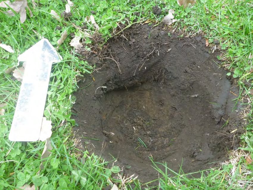
July 19, 2021                                                                                    1912764; 21451149

However, as the report is for the proposed New Civic Development until recently located on federal land within the
Central Experimental Farm, Parks Canada is the recognized federal authority in archaeology and, as a federal
custodian, the National Capital Commission (NCC) follows its lead and acknowledges and supports this position.
It is Parks Canada’s position that the Ontario Heritage Act does not apply to federal jurisdiction, as such,
archaeological work and collections recovered from the land are subject to federal legislation and policies.

                                                                                                                iii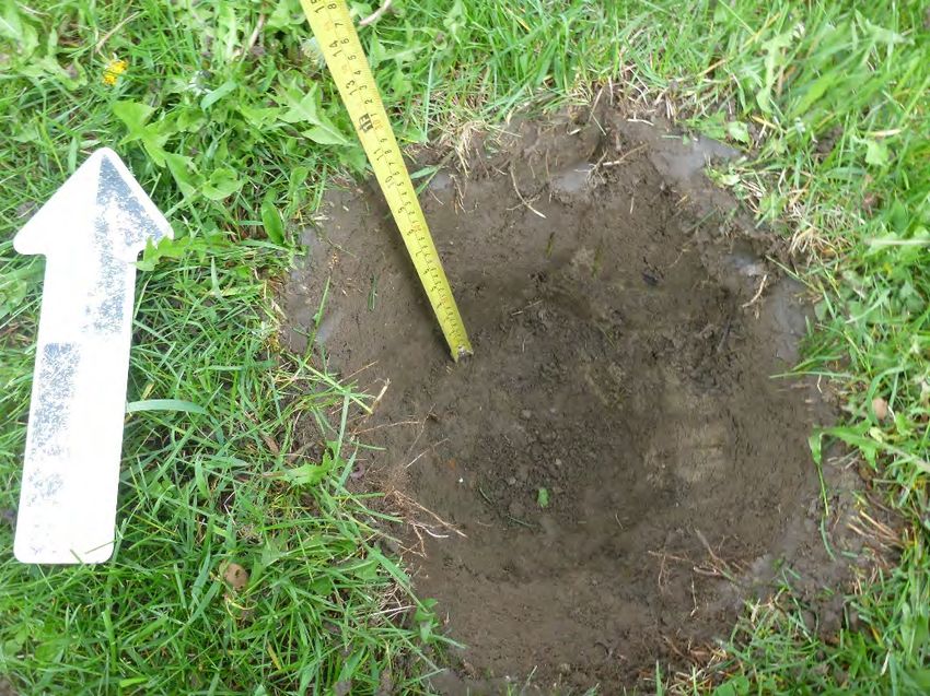
July 19, 2021                                                                                     1912764; 21451149

Project Personnel
Client Contact                               Ronald Clarke, MCIP, RPP
Project Director                             Chris Hendry, M.Eng, P.Eng.
Project Manager                              Kim McDonald
Archaeology Discipline Lead/
Material Culture Analysis                    Helen Moore, B.A. (R359), Material Culture Analyst

Senior Technical Review                      Michael Teal, M.A. (P364)
Report Preparation                           Randy Hahn, Ph.D. (P1107), Staff Archaeologist
                                             Helen Moore, B.A. (R359), Material Culture Analyst
Field Director/Licensee                      Randy Hahn, Ph.D. (P1107), Staff Archaeologist
Field Crew                                   Tatiana Istomina
                                             Alex Vasylenko
GIS/Mapping                                  Bojan Radojevic, B.A.
Administration                               Courtney Adey
Artifact Photos                              Joyce Rombouts

Abbreviations
ASDB              Archaeological Site Database

BP                Before Present, taken to mean before 1950 and used as an alternative to BC/AD
CHVI              Cultural Heritage Value or Interest
Golder            Golder Associates Ltd.
m                 Metre(s)
MHSTCI            Ministry of Heritage, Sport, Tourism and Culture Industries
NCC               National Capital Commission
ND                No Date
Parsons           Parsons Inc.
PIF               Project Information Form

                                                                                                                 iv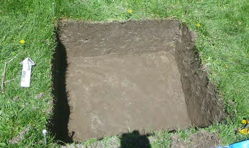
July 19, 2021                                                                                                                                     1912764; 21451149

Table of Contents
EXECUTIVE SUMMARY .......................................................................................................................................... ii

PROJECT PERSONNEL ........................................................................................................................................ iv

1.0     PROJECT CONTEXT ..................................................................................................................................... 1

       1.1        Development Context........................................................................................................................... 1

       1.1.1          Objectives ....................................................................................................................................... 1

2.0     HISTORICAL CONTEXT ................................................................................................................................ 1

       2.1        Regional Indigenous History ................................................................................................................ 1

       2.2        Early Euro-Canadian Settlement and Occupation along the Ottawa River ......................................... 9

       2.3        Nepean Township .............................................................................................................................. 13

       2.4        Study Area History ............................................................................................................................. 14

3.0     ARCHAEOLOGICAL CONTEXT .................................................................................................................. 15

       3.1        Study Area Environment .................................................................................................................... 15

       3.2        Previous Archaeology ........................................................................................................................ 16

       3.3        Known Archaeological Sites............................................................................................................... 16

       3.4        Stage 1 Recommendations ................................................................................................................ 17

4.0     FIELD METHODS ......................................................................................................................................... 17

5.0     RECORD OF FINDS ..................................................................................................................................... 18

       5.1        Operation 1......................................................................................................................................... 19

       5.2        Operation 2......................................................................................................................................... 20

       5.3        Operation 3......................................................................................................................................... 21

       5.4        Operation 4......................................................................................................................................... 22

       5.5        Operation 5......................................................................................................................................... 23

6.0     ANALYSIS AND CONCLUSIONS ................................................................................................................ 23

7.0     RECOMMENDATIONS ................................................................................................................................. 24

8.0     ADVICE ON COMPLIANCE WITH PROVINCIAL LEGISLATION .............................................................. 25

9.0     ADVICE ON COMPLIANCE WITH FEDERAL POLICY .............................................................................. 26

10.0 IMPORTANT INFORMATION AND LIMITATIONS OF THIS REPORT ...................................................... 27

                                                                                                                                                                             v
July 19, 2021 1912764; 21451149
11.0 REFERENCES ................................................................................................................................................ 1
12.0 IMAGES ........................................................................................................................................................ 12
13.0 MAPS ............................................................................................................................................................ 25
TABLES
Table 1: Summary of Previous Archaeological Assessment Studies within the Vicinity of the Study Area ........... 16
Table 2: Summary of Weather Conditions during Fieldwork .................................................................................. 17
Table 3: Inventory of Documentary Record ............................................................................................................ 18
Table 4: Operation 1 Artifacts by Function ............................................................................................................. 19
Table 5: Operation 2 Artifacts by Function ............................................................................................................. 20
Table 6: Operation 3 Artifacts by Function ............................................................................................................. 21
Table 7: Operation 4 Artifacts by Function ............................................................................................................. 23
IMAGES
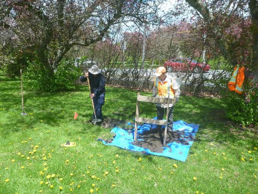
Image 1: Field crew conducting test pit survey north of the Old Hedge Collection in Operation 1, view
southwest. ............................................................................................................................................... 13
Image 2: Field crew conducting test pit survey in Operation 3, view north. ........................................................... 13
Image 3: Field crew conducting test pit survey in Operation 4, view west. ............................................................ 14
Image 4: Field crew conducting intensified test pit survey around positive test pit, view northwest. ..................... 14
Image 5: Field crew excavating 1 m2 test unit as part of the intensified survey over a positive test pit located
within Operation 3, view northeast. ......................................................................................................... 15
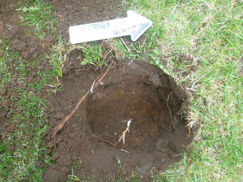
Image 6: Representative test pit from Operation 1 consisting of approximately 25 cm of dark grey brown
sandy loam over orange sand, view north. ............................................................................................. 15
Image 7: View north of Test Unit 11 (TP3) from within Operation 1 showing soils consisting of 27 cm dark
grey brown sand over tan sand. .............................................................................................................. 16
Image 8: Representative artifacts from Operation 1: top row (left to right): Machine cut nail (TP 03), wire nail
(TP 03), flower pot (TU 11/TP 04), slate pencil (TU 11/TP 04); bottom row (left to right): Albany
slipped stoneware storage vessel (TU 11/TP 04), and transfer printed tableware sherd (TP 05),
Canadian 1928 Penny (TP 02)................................................................................................................ 16
Image 9: Representative shovel test from Operation 2 consisting of approximately 30 cm of grey brown
sandy loam over tan sand subsoil. .......................................................................................................... 17
Image 10: View north of Test Unit 15 (TP14) showing disturbed soils consisting of 22 cm of grey-brown
sandy loam, over mottled grey and orange clay and orange sandy loam. The disturbance is likely
associated with a buried water line. ........................................................................................................ 17
Image 11: Bottle finishes found in Operation 2. Left to right: Threaded bottle (TU 15/TP 14, TP 12 NE) and
jar finishes (TP 14 E) and plastic closure (TU 15/TP 14). ....................................................................... 18
Image 12: Ceramic tableware from Operation 2 with CN branding (TP12, TU14/TP12). ...................................... 18
vi
July 19, 2021                                                                                                                                     1912764; 21451149

Image 13: Canadian National Railways Logos (left to right): Red Wafer 1927, CNR Maple Leaf 1943 and
        Canadian National Railways Maple Leaf 1954 (logodesignlove.com). ................................................... 19
Image 14: Operation 2 ceramic decoration types (left to right): dyed body (TU 15/TP 14) and transfer
        printed (TP 15). ...................................................................................................................................... 19
Image 15: Representative test pit from Operation 3 consisting of 26 cm of grey-brown clay loam over tan
        clay, view north........................................................................................................................................ 20
Image 16: View north of Test Unit 4 excavated over TP 46 showing 28 cm of grey-brown sandy loam over
        tan sandy loam subsoil. ........................................................................................................................... 20
Image 17: North profile of Test Unit 5 (TP22) showing soils consisting of 32 cm grey-brown sandy loam
        over tan sandy loam, view north. ............................................................................................................ 21
Image 18: Glass sherds from Operation 3 (left to right): lime green glass, “7UP” (TP 47), diamond mark (TU
        02/TP 45) and crown finish (TP 74). ....................................................................................................... 21
Image 19: Ceramic decoration types from Operation 3: top row (left to right): Yellow glazed CN sherd (TU
        02/TP 45), and two sherds with painted rim lines (TU 04/TP 46, TP 67); bottom row (left to right):
        sherd with blue painted edge (TP 25), decal decoration (TP 45), and transfer print (TU 05/TP 22). ..... 22
Image 20: Brown transfer print (TP 25 E) and blue edged sherd (TP 23) from Operation 3. ................................ 22
Image 21: Glass sherd with Owens suction scar and diamond mark (TU 04/TP 46). ........................................... 23
Image 22: Cobalt blue, machine-made container (TP 46 E) and clay smoking pipe bowl (TU 02/TP 45) from
        Operation 3.............................................................................................................................................. 23
Image 23: Test pit from Operation 4 consisting of dark grey-brown sand over orange-brown sand, view
        west. ........................................................................................................................................................ 24
Image 24: Landscaped slope along the northern edge of the Operation 3 artifact scatter leading down to the
        area disturbed by the former Sir John Carling Building, view southwest. The former location of the
        parking lot of the Sir John Carling Building is the lying area covered with dandelions. .......................... 24

MAPS
Map 1: Key Plan ..................................................................................................................................................... 26
Map 2: Site Plan ..................................................................................................................................................... 27
Map 3: 1827 and 1844 Historic Maps ..................................................................................................................... 28
Map 4: 1863 and 1879 Historic Maps ..................................................................................................................... 29
Map 5: Aerial Photography ..................................................................................................................................... 30
Map 6: Surficial Geology......................................................................................................................................... 31
Map 7: Stage 2 Results, Recommendations, and Photo Locations ....................................................................... 32
Map 8: Results of Stage 2 Test Pit Survey – Operation 3 19th Century Artifacts ................................................... 33
Map 9: Results of Stage 2 Test Pit Survey – Operation 3 20th Century Artifacts ................................................... 34

                                                                                                                                                                       vii
July 19, 2021        1912764; 21451149

APPENDICES
APPENDIX A
Artifact Catalogue

                                   viii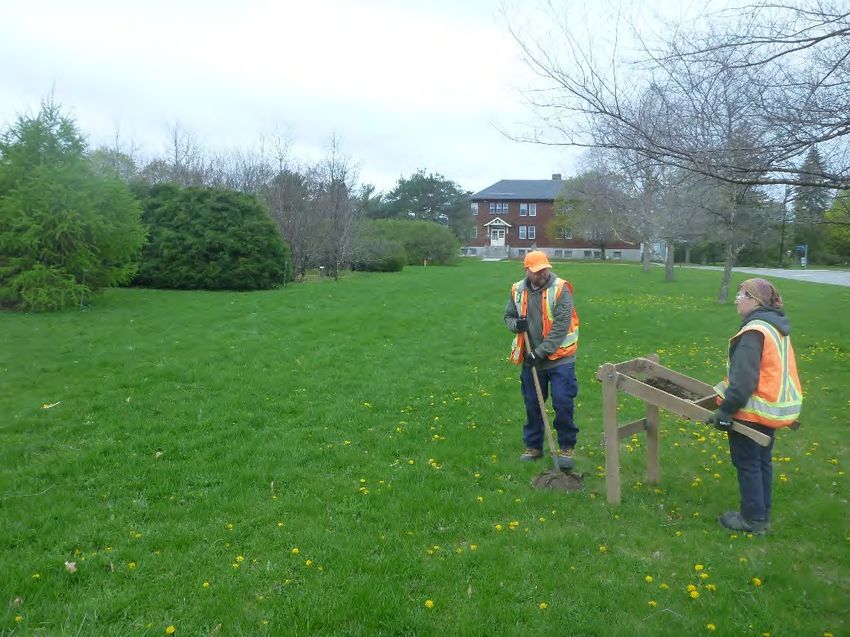
July 19, 2021 1912764; 21451149
1.0 PROJECT CONTEXT
1.1 Development Context
Golder Associates Ltd. (Golder) was retained by Parsons Inc. (Parsons) on behalf of The Ottawa Hospital to
conduct a Stage 2 archaeological assessment for the proposed new hospital campus, New Civic Development,
until recently on federal land within the Central Experimental Farm, part of lots I & K, Broken Front B, geographic
township of Nepean, City of Ottawa, Ontario (Maps 1 & 2). The study area is an approximately 20.6 hectare
property.
Permission to access the study area was provided by the client.
1.1.1 Objectives
The objectives of this Stage 2 archaeological assessment, which follow the MHSTCI Standards and Guidelines
for Consultant Archaeologists (2011, p. 27), include:
To document archaeological resources on the property.
To determine whether the property contains archaeological resources requiring further assessment.
To recommend appropriate Stage 3 assessment strategies for archaeological sites identified.
2.0 HISTORICAL CONTEXT
The following historical narrative is intended to provide a general overview of the interpreted land use during the
“Pre-Contact Period” and “Early Contact Period” within the vicinity of the current study area. This historical
overview is based on archaeological and historical interpretations inferred over the past 100 years, and generally
reflect inferences and interpretations made by non-Indigenous representatives. The text below is not intended to
provide a comprehensive historical overview of the occupation and landscape prior to, and following the arrival of
Europeans to the modern-day National Capital Region, but rather provide a general overview context that can be
referenced when determining the potential for archaeological resources within the current project study area.
The text and comments below, including the cited references, may reflect archaeological literature within general
publications, but are not suggested to represent the opinions of those Indigenous communities whose history it is
purported to reflect.
2.1 Regional Indigenous History
Paleo Period (11,000 BP to 10,000 BP)
The Ottawa Valley was covered by the Laurentide ice sheet until approximately 11,000 years before present (BP).
Following the period of deglaciation, the Ottawa Valley was inundated by the Champlain Sea which is interpreted
to have extended from the Rideau Lakes in the south, along the Ottawa Valley and St. Lawrence areas and
terminating in the vicinity of Petawawa in the west. The exact western boundary is unconfirmed as current
elevation levels reflect the isostatic adjustment of the land following the melting of the glaciers which has
obscured definitive traces of the Champlain Sea shoreline at the time of its existence. The eastern portion of the
sea extended into the Atlantic Ocean.
During the much of the Paleo Period (11,000 BP –ca. 10,000 BP), the National Capital Region would have
remained inundated by the Champlain Sea, although as the Champlain Sea receded towards the end of this
period it is possible that people migrated along the changing waterfront landscape eventually moving into the
Ottawa Valley (Watson 1999a).
1July 19, 2021 1912764; 21451149
Identifying the location and dates of the ancient Champlain Sea shorelines and the possible Paleo Period
archaeological sites that may been associated with this evolving landscape has proven challenging. These
boundaries are not marked by a continuous identifiable shoreline, especially in its western shore where rocky
conditions were not favorable to the formation of beaches (Chapman and Putnam 1973). Attempts to use deposits
of marine mollusk shells as a source for radiocarbon dates to delineate the transgression of the shorelines have
proved unreliable as shells absorb carbon at different rates according to their depth below the surface and
geological location (Robinson 2012). Additionally, earlier interpretations showing discrete stages of regression
(see Chapman 1937) have proven not to be supported by the geological record. Unlike the catastrophic flood
events during the Younger Dryas climatic event that led to the rapid formation of the Champlain Sea, its
regression was a slow process occurring as sea waters drained during isostatic rebound (Robinson 2012). The
interpretation of the presence of shorelines is further complicated by the fact that isostatic rebound may have
raised the Ottawa region above its current elevation before it receded to its current level (Fulton and Richards
1987). Flooding resulting from the overflow of glacial Lake Agassiz also eroded and manipulated topographic
landforms within the evolving landscape (Fulton et al. 1987). As a consequence, only the margins of the
Champlain Sea at its maximum extent, a time when the National Capital region would have been fully submerged,
have been reliably mapped due to the rapid inundation creating pronounced shoreline features (Loring 1980).
Although recent studies using various dating techniques that do not rely upon deposits of mollusk shells have
provided some favourable results (Tremblay 2008), considerable work remains in developing the chronology of
the Champlain Sea’s regression.
Early human settlement in the National Capital Region would have occurred following the recession of the
Champlain Sea when the vegetation and wildlife had the opportunity to develop within the area and enable the
sustainability of humans (Watson 1999a). The ridges and old shorelines of the Champlain Sea and early Ottawa
River channels reflect areas most likely to contain evidence of Paleo Period occupation in the region.
Archaeological and geological investigations in the Ottawa Valley have suggested these early sites may be
identified within the 550 foot (167.6 m) or higher contour topography, although additional research may be
required to confidently assess this correlation (Kennedy 1976).
The identification of Paleo Period sites in the National Capital Region has been hindered by the erosion of
accessible locations during the environmental changes associated with the transition from the Late Paleo Period
to the succeeding Archaic Period (8,000-950 BCE). The potential use of watercraft by Paleo Period peoples
(Engelbrecht and Seyfert 1995; Jodry 2005) and evidence for the abundance of marine resources (Loring 1980;
Robinson 2012) raises the possibility of occupation sites situated on accessible landforms such as those exposed
as isolated islands above the 167-metre elevation contours. As the Ottawa River delta prograded eastward during
the regression of the Champlain Sea (Fulton et al. 1987), these isolated exposed landscapes would have been
impacted by periods of overflow from glacial Lake Agassiz. The inundation of flood waters from the glacial lake
may have caused significant erosion, with another possibility being that the sediment transport facilitated by the
moving water may have buried archaeological remains within these potential occupation areas.
Archaeological sites documenting Paleo Period occupation have been excavated in southeastern Ontario,
although minimal evidence currently exists to delineate the limits of occupation in the National Capital Region
during this time when the majority of the landscape would have been submerged under the Champlain Sea.
Archaeological investigations within the National Capital Region that have produced diagnostic artifacts interpreted
to date to the Paleo Period include two bi-facially fluted projectile points found near the Rideau Lakes, which would
have been located near the shoreline of the Champlain Sea during this period (Watson 1999b).
2July 19, 2021 1912764; 21451149
Additional sites interpreted to have produced Paleo Period material have been recorded near Greenbank Road
(Swayze 2003) Albion Road and Rideau Road (Swayze 2004) southeast of the study area and at the Holy Spirit
site (MHSTCI 2020) and at the Moore Farm in the Outaouais region of Quebec (Laliberté 2006), although the lack
of diagnostic material represented at these sites and the inferred climatic environment suggests these sites may
rather be reflective of occupation during the later stages of the Paleo Period or during the Early Archaic Period
following the recession of the Champlain Sea.
Archaic Period (10,000 BP to 2,900 BP)
The environment began to approach modern conditions during the Archaic Period with the jack and red pine
forests that characterized the Late Paleo Period landscape being replaced by forests dominated by white pine
with some associated deciduous trees (Ellis et al. 1990). Occupation within the National Capital Region
developed as the environment became inhabitable, with an Early Archaic Period Dovetail projectile point
recovered in Ottawa South sometime around 1918-1920 (Pilon and Fox 2015) potentially representing the earliest
diagnostic evidence of human interaction within the local landscape.
An assemblage of lithic tools interpreted to date between approximately 11,000 and 9,000 BP was recovered from
a cluster of sites southwest of Parliament Hill in March Township (Swayze and McGhee 2011), although the lack
of diagnostic tools recovered from the site prevents the ability for uniform acceptance of the chronological and
contextual aspects of the site and the associated materials (Butler 2011). It is anticipated future investigations of
contemporary sites with similar artifact assemblages may provide further insight and evidence of human
occupation in the National Capital Region dating to the Early Archaic Period.
Populations occupying Ontario and Quebec during the Early Archaic Period primarily used large base camps on
islands, near river mouths, and on the shores of embayment’s where a variety of flora, fish, and wild fowl resources
could be obtained during the spring, summer and fall seasons. Smaller hunting and specialized campsites were
established in the uplands and along smaller watercourses. Access to these shoreline occupation areas, would have
been facilitated by a variety of Indigenous watercrafts such as bark canoes, skin boats and dugout canoes (Monk
1999).
The Indigenous peoples travelling along the Ottawa River are believed to have preferred a canoe that had high
ends, similar to later European traders who adopted this construction technique. These canoes were easily paddled
and designed to carry a heavy load with a narrow-flat bottom and flaring sides (Adney and Chapelle 2014).
Indigenous peoples utilized a variety of vessels to travel down navigable waterways such as the Ottawa, Gatineau
and Rideau river systems to meet, trade and exchange information. Several portages were required along the
Ottawa River, for example at the Chaudière Falls, Chats Falls and the Deschênes Rapids, with the primary
portage routes traversing the northern shoreline of the Ottawa River to avoid the marshy bayous and limestone
cliffs prominent on the south side of the river (ASI and GII 1999). Pre-Contact Period Indigenous artifacts
recovered near the Deschênes Rapids on the north side of the Ottawa River may reflect evidence of a former
encampment associated with this portage route (GRAO 2012; Pilon 2010) and another site interpreted to
represent seasonal occupation during the Archaic, Woodland and Post-Contact Periods may also be associated
with the former portage route utilized to bypass the Chaudière Falls along the northern shoreline of the Ottawa
River (Arkeos 1993).
These waterways represent the historical highways facilitating the movement of both people and goods through
the region. Archaeological discoveries made in the area around Gatineau and Ottawa illustrate the existence of
an extensive, continent-scale network of communication and trade with the discovery of a variety of raw materials
used for stone tool production including Ramah Chert from the tip of Labrador, Mistassini Quartzite from the
centre of Québec, Hudson’s Bay Lowland Chert from the region bordering Hudson Bay, abundant Onondaga
Chert obtained from the Onondaga Escarpment region south and west of Lake Ontario, as well as distinctive
Mercer and Burlington Formation cherts from Ohio and Illinois respectively (Pilon and Boswell 2015).
3July 19, 2021 1912764; 21451149
The National Capital Region was also an important route for the movement of copper, either through direct trade
between individual groups, or through trips to Lake Superior to exploit the native copper deposits located there.
Copper artifacts similar to those documented on Allumette Island in the Ottawa River have been discovered in
Wisconsin, Michigan, New York State and Manitoba (Kennedy 1970). This commodity, as well as other tradable
goods, was presumably transported by canoes and other vessels along the navigable waterways including the
Ottawa River.
Sites with Archaic Period components that demonstrate this expanding trade network include in the Rideau Lakes
area (Watson 1982) and Morrison Island and Allumette Island in the Outaouais region of the Ottawa River
(Chapdelaine et al. 2001; Clermont 1999). The Gatineau River also represent a significant waterway
transportation route during this period, with a complex of sites identified near this junction at Lake Leamy
(Laliberté 1997) and the site registered as Borden Number BiFw-172 located on the south shore of the Gatineau
River near the intersection with the Ottawa River. The copper artifacts recovered from the BiFw-172 site may
reflect contemporary trade occurring along the Gatineau and Ottawa waterways and the strategic importance of
this site. Seven charcoal samples collected from the BiFw-172 site were radiocarbon dated indicating an
occupation between 6320 (+/- 25) and 2660 (+/- 30) years BP. Although this occupation was likely seasonal, it
suggests this site was visited and occupied over a period of almost 4,000 years, and likely longer (Archéotec
2015). Additional significant occupation sites producing Archaic Period artifacts along Ottawa Valley waterways
include Jessup Falls near the intersection of the South Nation River and the Ottawa River and at Spencerville
near the source of the South Nation River (Daechsel 1980).
The National Capital Region was also one of the primary corridors along that early technological information and
techniques were transmitted (Kennedy 1970). One of the more notable changes during the Early Archaic Period
was the appearance of side and corner-notched projectile points.
During the Middle Archaic Period (8,000 BP – 4,000 BP) the trend towards more diverse toolkits continued, as the
presence of netsinkers and fish weirs suggest that fishing was becoming an important component of the
subsistence strategy. It was also during this period that stone tools specifically designed for the preparation of
wild plant foods were crafted and when ‘bannerstones” were first manufactured, which are carefully crafted
ground stone devices that served as a counterbalance for atlatls or spear-throwers. An example of a bannerstone
was recovered from Leamy Lake Park on the north side of the Ottawa River (Ian Badgley, pers comm.).
The increased trade relationships may have also influenced the transition from nomadic lifestyles across large
areas to more centralized occupation within smaller areas that provided the opportunity to facilitate interaction
with those conducting trade, whether it was “down-the-line” or controlled by individuals interacting directly with
different groups. This development of a less-nomadic lifestyle is also reflected in the adaptation of ground stone
tools such as celts and axes, which suggest the beginning of a simple woodworking industry. The presence of
these often large, and not easily portable, tools also imply there may have been some reduction in the degree of
seasonal movement. Another noticeable attribute during the Middle Archaic Period is the increased reliance on
local, often poor quality, chert resources for manufacturing projectile points. While groups occupied larger
territories during the Paleo and Early Archaic Periods and were able to visit primary outcrops of high-quality chert
at least once during their seasonal round, during the Middle Archaic Period groups traveled within comparatively
smaller territories that did not always possess a source of high-quality raw materials. In these instances, lower
quality resources that had been previously deposited by the glaciers in the local till and river gravels were utilized.
This reduction in territory size may also be representative of a gradual region-wide population growth that led to
infilling of the landscape. This process resulted in a reorganization of Indigenous subsistence strategies, as more
people had to be supported from the resources extracted from a smaller area.
4July 19, 2021 1912764; 21451149
Representative burial and interment practices during the Archaic Period can also reflect patterns in land use and
the importance of specific landscape attributes to the contemporary populations. The oldest known human burial
in the general region has been documented at Coteau-du-Lac, located east of the study area within the St.
Lawrence River region less than 15 kilometres from the mouth of the Ottawa River. The diagnostic artifacts
recovered within this burial deposit were consistent with a Vergennes Focus of the Laurentian Archaic cultural
attribution (Pilon and Young 2009).
Several burials dating to the Archaic Period have also been documented on the north side of the Ottawa River,
just east of the Chaudière Falls. Many of these burials were observed during the mid-19th century, with upwards of
twenty individuals documented along the northern shore of the Ottawa River between the Chaudière Falls and the
Gatineau River. Many of these interments were associated with red ochre deposits, although there does not
appear to be a consistent deposition positional pattern to those recorded (Pilon and Boswell 2015).
Archaic Period burial deposits have also been recorded within the vicinity of the Ottawa River. Edwin Sowter has
provided an account of assisting with the exhumation of several skeletons on Aylmer Island (also known as
Lighthouse Island) and describes the assortment of artifacts associated with these features (Sowter 1915; Sowter
1900). Upwards of 17 skeletons (exact number cannot be confirmed) may have been found on Aylmer Island
within the vicinity of the lighthouse, with many either found during the lighthouse construction in the early 19th
century or discovered later eroding from the sand. The artifacts and grave context suggest this area was utilized
as a burial ground during the Archaic Period and continued through to the Post-Contact Period (Pilon and Young
2009).
A single Late Archaic Period burial deposit was identified on the south side of the Ottawa River near the shoreline
just east of Arnprior. This single feature was associated with a red ochre deposit, although the context was
significantly disturbed when it was originally discovered during construction activities in the area (MHSTCI 2020)
and it cannot be confirmed if additional burials are located in the vicinity.
Significant burial deposits have also been documented on both Morrison Island and Allumette Island, which are
situated within the Ottawa River near Pembroke, west of Victoria Island. As many as 54 individuals are known
from burial contexts dated to the Archaic Period on Allumette Island, although disturbances from 20th century
ploughing activities have impacted the burial context and made it difficult to infer additional information (Pilon and
Young 2009).
Although there are some discrepancies in the field notes and documentation regarding the number of Archaic
Period burials on Morrison Island, conservative accounts indicate upwards of twenty individuals from twenty-two
burial features (Pilon and Young 2009). Twelve of the burials yielded copper objects, which are considerably rare
(Clermont and Chapdelaine 2009) and may reflect the importance of trade relationships and the strategic location
of Morrison Island within the Ottawa River.
All these Archaic Period burial sites are situated along waterways and all are located either near the shoreline or
on islands within the Ottawa River. Another common attribute is that many are situated within strategic locations
or within proximity to waterfalls or rapids, which may represent the importance of these natural features within the
Archaic Period maritime cultural landscape.
Similar to the spatial distribution of known burial sites, the majority of Archaic Period occupation sites have been
documented along navigable waterways. In addition to the inferred burial locations on the north side of the Ottawa
River on the grounds of the Canadian Museum of History, a number of sites investigated within Leamy Lake Park
have yielded evidence of Late Archaic Period occupation. Archaeological sites with Late Archaic Period components
have also been recorded across the Ottawa River from Leamy Lake Park at Portage Bay and Rockcliffe Park
(Cardieux 2005; Pilon and Boswell 2015).
5July 19, 2021 1912764; 21451149
Sites with Archaic Period resources documented along the Ottawa River include Allumette and Morrison Islands
(Clermont and Chapdelaine 2009), the Sawdust Bay 2 site located near Arnprior (Daechsel 1981) and a site at
Constance Bay which was observed to be “partially submerged” with material interpreted to be “possibly Late
Archaic” (MHSTCI 2020).
The Woodland Period (2,900 BP to 400 BP)
The Early Woodland Period (950 - 200 BCE) is distinguished from the Late Archaic Period primarily by the
addition of ceramic technology. The first ceramic pots were thick walled, and friable and may have initially been
utilized in the processing of nut oils by boiling crushed nut fragments in water and skimming off the oil (Spence et
al. 1990). These vessels were not easily portable, and their fragile nature suggests they may have required
regular replacement. One example of this type of ceramic pot was located along the Ottawa River at registered
site CaGi-1 in Gatineau, Québec (Watson 1999b) and several Vinette sherds have also been recovered from a
site in Leamy Lake Park (Ian Badgley, pers. comm.). Over time, pottery became more refined and began to
incorporate elaborate decorative patterns and distinctive styles representative of specific regional populations as
well as specific date ranges (Laliberté 1999).
Middle Woodland Period inhabitants continued to rely on ceramic technology, with vessels dating to this period
often decorated with impressed designs covering the entire exterior surface and upper portion of the vessel
interior (Martin 2004; Crawford et al. 1997; Bursey 1995; Ferris and Spence 1995; Spence et al.1990; Williamson
1990; Ritchie 1971). These stylistic variations provide the ability to easily identify Middle Woodland Period vessel
fragments from those manufactured during other periods.
The thin, well-made, projectile points that were produced during the terminal part of the Archaic Period continued
in use, although the Early Woodland Period variants were side-notched rather than corner-notched, giving them a
slightly altered and distinctive appearance. Through the last 200 years of the Early Woodland Period, projectile
points manufactured from high quality raw materials from the American Midwest begin to appear in southern
Ontario, potentially reflecting long-distance commodity trading (Spence et al. 1990).
The evolution of artifact manufacturing during the Woodland Period is partially reflective of settlement patterns
and provides additional insight into the transition of technological developments likely disseminated from the
interaction between different communities and trade partners.
While Middle Woodland Period inhabitants continued to rely on hunting and gathering to meet their subsistence
requirements, an increased consumption of fish became an important component of the contemporary diet. Some
Middle Woodland Period sites have produced thousands of bones from spring spawning species such as walleye
and sucker. Food sources such as shellfish, tree nuts and a proliferation of plant greens and seeds began to be
exploited and the seasonal variety and relative dependability of these foods encouraged population increases in
many areas.
Towards the end of the Middle Woodland Period (approximately 1,500 years ago) agriculture was introduced and
developed into a significant role in subsistence strategies. Beginning with the cultivation of corn, beans and
tobacco, agricultural production eventually influenced the development of semi-permanent and permanent
villages in southern Ontario. Many of these villages were surrounded by defensive palisades, suggesting
increased hostilities between neighbouring groups, which was more common in regions with arable land such as
southern Ontario. An example of a palisaded village dating to the Woodland Period has been documented south
of the National Capital Region at the Beckstead site (Pendergast 1984).
6July 19, 2021 1912764; 21451149
The increased population and semi-nomadic lifestyle prevalent within the National Capital Region during the
Woodland Period are reflected in the distribution of sites documented during archaeological investigations. Within
the general Ottawa Valley, Woodland Period sites have been recorded within the South Nation Drainage Basin
(Daechsel 1980), near Casselman (Clark 1905) and within the City of Ottawa near Bank Street (Golder 2014).
Two sites (Borden Numbers BhFx-46 and BhFx-66) (MHSTCI 2020) are situated inland and may represent
strategic subsistence or resource extraction sites prevalent during this period.
The majority of known archaeological sites dating to the Woodland Period in the general study area vicinity are
situated along navigable waterways, with the Rideau and Ottawa Rivers representing the two primary
transportation corridors. At least six sites with Woodland Period components have been documented along the
Rideau River between the Ottawa River and Manotick including BiFw-3 (Jamieson 1989), BiFw-101 (MHSTCI
2020), BiFw-1 (MHSTCI 2020), BhFw-6 (MHSTCI 2020), BhFw-110 and BhFw-112 (Golder 2017).
The importance of the Ottawa River as a navigable transportation route, as well as an area of resource and
subsistence extraction, through this period is reflected in the number of known archaeological sites documented
on both sides of the river to the east and west of Victoria Island.
Woodland Period sites on the north side of the Ottawa River include those recorded by Edwin Sowter near the
former Gilmour Mill site and another just east of the Alexandra bridge (Sowter 1915), a small seasonally occupied
site dating to the Middle to Late Woodland Period in Jacques Cartier Park (Laliberté 2002), another registered as
Borden Number BiFw-23 in Jacques Cartier Park (GRAO 2013) and a complex of sites investigated at Leamy
Lake Park, with many indicating a continued, likely seasonal, presence spanning the Late Archaic Period to the
Late Woodland Period (Pilon 2006; Pilon 2005; Laliberté 1997). Sites with a Woodland Period component have
also been located across from Leamy Lake Park on the south side of the river at Rockcliffe Park (Pilon and
Boswell 2015). Two small undiagnostic ceramic sherds dating to the Woodland Period were recovered during
excavations on Parliament Hill (CARF 1992), as well as a red-ochre stained ceramic sherd, a shell bead and a
piece of red ochre recovered from a previously disturbed context in the vicinity of Centre Block (Heritage Quest
1996).
Several sites have been documented along the north shore of the Ottawa river including one near Aylmer (Sowter
1915), another just west of the Champlain Bridge registered as BiFw-39 (Laliberté 1998a; Laliberté 1998b), at
Indian Point in the Pembroke area (Pilon 2005) and near the convergence of the Schvan and Ottawa Rivers
(Kennedy 1964).
Sites investigated along the south side of the Ottawa River provide additional insight into the settlement
distribution and land use during the Woodland Period. Evidence of Woodland Period occupation near the
southern Ottawa River shoreline include those discovered across from Aylmer at Raymond Point (Sowter 1915;
Sowter 1901; Sowter 1900), near Shirleys Bay and Rocky Point (Jamieson 1989), Constance Bay (Watson 1972;
Savage 1972), Marshall’s and Sawdust Bays (Daechsel 1981) and on Morrison Island (Pilon and Boswell 2015;
Pilon and Young 2009; Kennedy 1966).
Post-European Contact (Post 400 BP)
The Algonquin communities located along the same river networks used for transportation by early French traders
positioned them to monopolize the early fur trade. Beginning with the expedition of French explore Samuel de
Champlain to Montreal in 1603, the two communities became close allies. This alliance continued when
Champlain traveled to the National Capital region in a later expedition in 1613. Competition for furs increased
existing tensions between the Algonquin communities and their neighbours including the Haudenosaunee
Nations, such as the Mohawk, residing to the south in what is now Ontario and New York. The 17th century saw a
long period of conflict known as the Beaver Wars between the Algonquin and the Haudenosaunee that resulted in
the significant disruption of life. Mohawk raids against Algonquin Villages in the Upper Ottawa and St. Lawrence
Valleys resulted in the abandonment or destruction of many Algonquin villages in these areas (Trigger and Day
7July 19, 2021 1912764; 21451149
1994). Some Algonquin’s found refuge in French settlements such as Trois Riviére, Quebec City, Sillery, and
Montreal while others may have retreated to interior locations along the Ottawa River’s tributaries (Holmes 1993).
At the end of the 17th century, the Haudenosaunee were driven out of much of southern Ontario by the
Mississaugas though they continued to occupy parts of eastern Ontario on a seasonal basis.
The French brokered a peace treaty in 1701 at Montreal where the Algonquin, the French, and the
Haudenosaunee agreed to peacefully share the lands around the Great Lakes (INAC 2011). In exchange for
peace, the Algonquin gave the Haudenosaunee secure access to furs which the Haudenosaunee used to secure
their alliance with the British. Between 1712-1716, Algonquins were noted as living along the Gatineau River with
the Haudenosaunee occupation located south of the St. Lawrence (Holmes 1993). By 1740, Algonquin
communities were present in the vicinity of Trois-Rivieres, Riviere Lievre and Lake of Two Mountains and
Mohawk community members were residing near Lake of Two Mountains (Holmes 1993).
Following the Seven Years’ War in the mid-18th century, the defeat of the French, Algonquin, and their allies by
the British and the Haudenosaunee resulted in the further loss of Algonquin hunting territories in Southern
Quebec and Eastern Ontario as the British seized France’s colonies. The extension of Quebec’s boundaries in
1774 through the Quebec Act and the use of the Ottawa River as the boundary of Upper and Lower Canada
following the 1791 Constitution Act separated the Algonquins between two government administrations (AOP
ND).
Britain’s colonial policy differed from the French in that the Crown was much more interested in securing land
surrenders from the Indigenous populations for settlement by Europeans. The Royal Proclamation of 1763 issued
by King George III enabled the Crown to monopolize the purchase of Indigenous lands west of Quebec. Although
the proclamation recognized Indigenous rights to their land and hunting grounds, it also provided a way through
which these rights could be taken away (Surtees 1994). Land cession agreements between Indigenous groups
and the Crown increased following the War of 1812 as a new wave of settlers arrived in Upper Canada primarily
from Britain.
The Crown implemented annuity systems in the purchase of lands from Indigenous peoples where the interest
payments of settlers on the land would cover the cost of the annuity rather than pay a one-time lump sum. By the
1850s, Indigenous groups had become cautious of these agreements and had began to demand the retention of
reserved land and preservation of hunting and fishing rights (Surtees 1994).
Land cession agreements between Indigenous groups and the Crown increased following the War of 1812 as a
new wave of settlers arrived in Upper Canada primarily from Britain. The Crown implemented annuity systems in
the purchase of lands from Indigenous peoples where the interest payments of settlers on the land would cover
the cost of the annuity rather than pay a one-time lump sum.
The Crown again negotiated with the Mississauga of the Bay of Quinte and Kingston areas during the Rideau
Purchase (1819/1822) which included a portion of Algonquin territory in the Ottawa Valley (Surtees 1994). The
Algonquin and Nipissing, who were left out of the talks, protested the purchase, but were largely ignored (Holmes
1993). The Rideau Canal was later built through the territory of the Rideau Purchase. In 1839, the Crown denied
the Algonquins and Nipissings the right to lease portions of their land, including islands in the Ottawa River, to
settlers with whom they had previously been collecting rent payments (Holmes 1993). Furthermore, the Crown did
little to prevent further additional encroachments by settlers on Indigenous lands. By the 1850s, Indigenous
groups had become cautious of these agreements and had began to demand the retention of reserved land and
preservation of hunting and fishing rights (Surtees 1994).
8July 19, 2021 1912764; 21451149
A reserve was purchased for use by the Algonquins in Golden Lake in 1873 (Holmes 1993). The Golden Lake
reserve, now known as the Algonquins of Pikwakanagan First Nation, has a registered population of around 2,000
people with over 400 living on the reserve (INAC 2013). Additional reserves and settlements for the Algonquins
were established in Quebec during the mid-20th century.
The Indian Act of 1876 framed the relationship between the Canadian government and Canada’s Indigenous
peoples as a paternalistic one where the government served as their guardian until their cultures were able to
integrate into Canadian society (INAC 2011). The Department of Indian Affairs was granted the authority to make
policy decisions such as determine who was classified as Indigenous, manage their lands, resources and money,
and promote “civilization”. The consequence was the further erosion of Indigenous rights to autonomy and
self-governance. The implementation of residential schools and adoption of Algonquin children by non-Indigenous
families in the mid-20th century reflected further discrimination and the disregard of rights (AOP ND).
The Algonquins today are represented by groups including the Algonquins of Ontario and the Algonquin
Anishinabeg Nation Tribal Council. The Algonquins of Ontario consists of ten communities: Antoine, Algonquins of
Pikwakanagan First Nation, Bonnechere, Greater Golden Lake, Kijicho Manito Madaouskarini, Mattawa/North
Bay, Ottawa, Shabot Obaadjiwan, Snimikobi, and Whitney and Area (AOO ND). The Algonuin Anishinabeg Nation
Tribal Council consists of seven communities: Abitibinni, Eagle Village, Kitigan Zibi, Lac Simon, Long Point,
Kitcisakik and the First Nation of Wahgoshig. Of these, all but Wahgoshig are located within Quebec.
The Ottawa Valley is unceded Algonquin land and land claim negotiations with Canada and Ontario are in
progress. The Algonquin and the Government of Canada signed an agreement in principle to transfer 117,500
acres of Crown lands in eastern Ontario to the Algonquin (INAC 2016; Tasker 2016). While this represents an
important step in the negotiations, the talks are ongoing.
2.2 Early Euro-Canadian Settlement and Occupation along the Ottawa
River
Étienne Brûlé is reported to have been the first European to pass through what is now the Ottawa area when he
portaged at the Rideau Falls in 1610, followed by Nicholas de Vignau in 1611. In 1613, Samuel de Champlain
paddled from Montreal to Morrison Island along the Ottawa River (Croft 2006), which was commonly known as
the Grand River (Kichi Sibi in Algonquin) or the River of the Algoumequin (Pilon 2005).
Champlain’s party made the trip up the Ottawa River in bark canoes, which were likely similar to those used by
the Indigenous Peoples on the same river before him and the European traders who followed. Due to the falls at
Asticou (Chaudière), Champlain’s party would have been forced to portage to the upper part of the Ottawa River
and likely followed the same route utilized by the Indigenous communities along the north side of the river. It
would have been during this segment of the journey that Champlain would have observed Victoria Island while
approaching the falls and continuing to travel between the falls at Asticou and Lac Deschênes where they spent
the night of June 4 (Sulte 1915). Champlain’s party continued until they reached Morrison Island in the Ottawa
River, near present-day Pembroke, where he interacted with Chief Tessoüat, and following several conversations
decided to return towards Montreal via the Ottawa River (Fischer 2008). Representing one of the first Europeans
to travel the Ottawa River, Champlain is credited with creating the first map of the area, as well as naming many
topographic features within the Ottawa River landscape (Fletcher 2004).
The Ottawa River continued to serve as a major transportation corridor following Champlain’s voyage, with the
waterway becoming a principal route for succeeding explorers, missionaries and traders travelling from the St.
Lawrence River to the interior and towards Georgian Bay.
9You can also read