Support Document for the public consultation period for the International Joint Commission's Lake Champlain-Richelieu River Flood Study
←
→
Page content transcription
If your browser does not render page correctly, please read the page content below
4 February 2022 draft

Support Document for the public consultation
period for the International Joint Commission’s Lake
Champlain-Richelieu River Flood Study

February 2022 (Draft)

The contents of this document have been developed contemporaneously with the completion of
important activities, such as the public consultation process, final development of supporting
documents, and with the refinement and continued iteration of Study Board Recommendations.
Therefore, please be advised that this is a study "in process" and this document reflects what is
known "at the moment" and the final findings, recommendations, as well as the validation of
remaining information will change as the Study Board moves towards an end-of-March, 2022
conclusion to its work.

Study findings and recommendations as of January 28, 2022; subject to change. The final report is
scheduled for release in April 2022.
DRAFT for public consultation                                                                    February 7, 2022

A Note from the Study Co-Chairs

Following catastrophic flooding along the shorelines of Lake Champlain and the Richelieu River in
Quebec during the spring of 2011, the governments of Canada and the United States asked the
International Joint Commission (IJC) to review the causes and develop potential solutions to minimize
impacts of future flooding in communities across the basin. The International Lake Champlain-Richelieu
River Study Board was established in 2016. Since then, groups of experts have investigated scientific,
engineering, environmental and socio-economic aspects of the problem and developed draft
recommendations that can offer real, long-term benefits that reduce flooding and its impacts on the
Lake Champlain and Richelieu River communities. The Study has prioritized learning from past
experiences and current perspectives of citizens, speaking with community leaders and organizations
about emergency response, economics, social and environmental concerns, as well as consulting
decision-makers in federal, state, and provincial governments. These important social, political and
economic considerations were integrated with modern scientific models to improve real-time flood
forecasting in both countries and collaborative tools to support effective decision-making. As a result,
the Study’s draft recommendations reflect the concerns of basin communities in both countries and
support workable approaches to reduce flooding and its impacts. Water level extremes of a system like
the Lake Champlain and Richelieu River watershed can never be completely controlled, especially in the
face of a changing climate. Nevertheless, thoughtful structural and non-structural approaches can be
implemented over time to improve community resilience and reduce risks to life and property.

 Jean-François Cantin, Canada Co-Chair                    Deborah H. Lee, United States Co-Chair

The members of the Study Board were appointed by the International Joint Commission to provide the
expertise needed to prepare this report. Although they are employed by government agencies in both
Canada and the United States, they serve the Commission in their personal and professional capacities
and not as representatives of their agencies. The report was developed by the Study Board and should
not be considered as official opinions, positions, or commitments of any organizations, agencies or
departments named in this report.

                                                                                                                  1
Study findings and recommendations as of January 28, 2022; subject to change. The final report is scheduled for
release in April 2022.
DRAFT for public consultation                                                                    February 7, 2022

Report Contents

This report addresses some of the key findings from the multi-year Lake Champlain-Richelieu River Study
(the Study) and is organized around a set of four questions:

    •    How did we get where we are today?

    •    What has the IJC done to try to find solutions?

    •    What should be done in the future?

    •    What comes next?

Study Themes

The Study is based on cutting edge science and includes public engagement elements, interwoven
throughout, to produce a set of draft recommendations that are summarized here. The icons below
reflect the four Study themes (Figure 1) and are used in the report to identify areas where the themes
are discussed in more detail. Findings and draft recommendations are highlighted with a magnifying
glass icon.

                                                                   The Study analyses included the following
                                                                   objectives:
                                                                   • Understanding causes and impacts of
                                                                   past floods
                                                                   • Identifying floodplain best management
                                                                   practices
                                                                   • Developing flood adaptation strategies
                                                                   • Evaluating a binational real-time flood
                                                                   forecasting and mapping system
                                                                   • Exploring potential flood management
                                                                   and mitigation measures, including both
                                                                   non-structural and moderate structural
                                                                   measures
                                                                   • Analyzing social and political perception
                                                                   to measures

Figure 1. LCRR Study framework and primary themes

                                                                                                                  2
Study findings and recommendations as of January 28, 2022; subject to change. The final report is scheduled for
release in April 2022.
DRAFT for public consultation                                                                    February 7, 2022

Criteria for Evaluating Recommendations
To evaluate its recommendations, the Board identified seven decision criteria:
    • Within the scope and mandate of this binational study, which stipulates only moderate
         structures will be considered
    • Implementable, consistent with feedback from stakeholders, agencies and elected officials
    • Technically viable, based on sound engineering and effective in reducing flood damages
    • Economically viable, with benefits that exceed the cost, and not cost-prohibitive
    • Fair and equitable, broadly benefitting society and not particular interest groups, nor having
         disproportionate negative impacts on a particular group
    • Environmentally sound, protecting key ecosystem services and having minimal detrimental
         impacts
    • Resilient to climate change, providing benefits across a wide range of possible climatic scenarios

Potential measures to reduce flooding and its impacts were evaluated through the lens of these criteria.

Recommendations

                 Reduce water levels:

                 The Study Board recommends the IJC advise governments that it is possible to achieve a
                 modest relief of flood (on the order of 10 cm on the Lake and 15 cm at Saint-Jean-sur-
                 Richelieu for an event like the 2011 flood) and drought water levels by returning the
                 hydraulic regime at the Saint-Jean-sur-Richelieu shoal to a more naturalized hydraulic
                 state. This can be achieved by removing some flow-impeding human artifacts in addition
                 to some selected excavations of the shoal and installing a submerged weir in the area of
                 the Saint-Jean-sur-Richelieu shoal. From the Study’s evaluation of the proofs of concept,
                 this moderate structural solution is technically feasible, economically beneficial, and
                 socially acceptable. Also, based on the Study's analysis with environmental performance
                 indicators, it appears that the structural solution has positive environmental impacts
                 and no significant negative environmental impacts.

                 If desired, additional flood relief can be gained through combining the removal of the
                 artifacts, selected excavations of the shoal, and the submerged weir with a modest
                 water diversion through the Chambly Canal (for a total water level reduction of 15 cm
                 on the Lake and 20 cm at Saint-Jean-sur-Richelieu for an event like the 2011 flood).
                 While this alternative that includes the Chambly Canal water diversion is less
                 economically performant, this addition brings greater water level relief for larger flood
                 events and should be presented to the governments for their considerations.

                 If the governments decide to implement a structural solution, a process should be put in
                 place to analyze binational social, political, environmental and economic implications of
                 the final structure design and operation.

                                                                                                                  3
Study findings and recommendations as of January 28, 2022; subject to change. The final report is scheduled for
release in April 2022.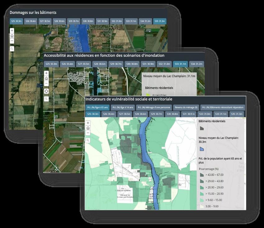
DRAFT for public consultation                                                                    February 7, 2022

                 Impede flows:

                 The Study Board recommends that the IJC encourage the governments to continue
                 protection of existing wetlands, as they provide flood relief (reduction of the peak water
                 level by 15 cm in Lake Champlain and 12 cm in the Richelieu River during a 2011-scale
                 flood) at the scale of lakeshore and Richelieu riverfront communities.

                 The Study Board recognizes that wetlands reduce local tributary flooding, support
                 biodiversity, and have important environmental co-benefits. Consequently, the Study
                 Board wishes to encourage governments to continue to protect these existing wetlands
                 and, where possible, to restore lost wetlands and create new ones.

                 However, the LCRR Study has determined that without the creation of a very large area
                 of new wetlands, there cannot be significant flood mitigation at the scale of lakeshore
                 and Richelieu riverfront communities during major flood events. Therefore, the Study
                 Board does not recommend pursuing a strategy for acquiring land and creating new
                 wetlands as a flood management policy for lakeshore and Richelieu riverfront
                 communities.

                 Flood response:

                 The Study Board recommends that all of the weather and hydrological information
                 generated by NOAA 1 (in the United States) and ECCC 2 and MELCC 3 (in Canada) be made
                 available to and used by the respective agencies responsible for the production and
                 dissemination of flood forecasts, guidance and warnings.

                     •    Continuation and enhancement of the collaboration between the various
                          Agencies, namely NOAA, ECCC and MELCC, must be encouraged to ensure all
                          available forecast data and their interpretations are shared in real time, with the
                          ultimate goal that the official forecasts on each side of the border are of the
                          highest possible quality and are accompanied by a concerted and consistent
                          cross-border interpretation.
                     •    Improved modelling and forecasting tools developed for the Lake Champlain-
                          Richelieu River basin can greatly aid flood response planning and should be
                          maintained. They showed the possibility of extending the forecasting horizon
                          and providing new operational products relevant to the basin’s stakeholders,
                          such as water set-up, waves, flood extent and depth, and their consequences on
                          the shore, for example: roads cut off, social vulnerabilities, and monetary
                          impacts.

                 On that basis, the governments are encouraged to operationalize the improved
                 modelling and forecasting tools and coherent risk assessment systems and

1
  US National Oceanographic and Atmospheric Association
2
  Environment and Climate Change Canada
3
  Ministère de l'Environnement et de la Lutte contre les changements climatiques (Ministry of the Environment
and the Fight Against Climate Change)
                                                                                                                  4
Study findings and recommendations as of January 28, 2022; subject to change. The final report is scheduled for
release in April 2022.
DRAFT for public consultation                                                                    February 7, 2022

                 support/maintain them after the Study. The LCRR tools, supporting data and
                 documentation should be transferred to appropriate agencies in Canada and the US by
                 no later than the end of 2022.

                 To support flood preparedness, simulations of flooding of various magnitudes and the
                 related maps produced should be made available to all interested parties by no later
                 than the end of 2022.

                 Floodplain management:

                 The Study Board recommends also that the IJC encourage the governments to make the
                 best use, in relation with their own context, of the LCRR Study’s analysis of best
                 practices related to risk mapping, risk communication, floodplain management and
                 flood insurance.

                     •    Enhance flood risk mapping for targeted audiences. This includes updating and
                          adding more details to existing flood risk maps.
                     •    Develop flood risk communication campaigns designed for specific target
                          audiences within the LCRR basin.
                     •    Consider floodplain occupancy through the lens of resiliency. This includes land
                          use strategies that avoid, accommodate and retreat from flooded areas,
                          updating and strengthening the enforcement of land use regulations based on
                          flood risk, and shielding development in high-risk flood zones.
                     •    Explore and/or expand flood insurance. This includes further investigation of the
                          state of flood insurance in the watershed and promoting an insurance
                          arrangement that shares financial liability for flood damages.

                                                                                                                  5
Study findings and recommendations as of January 28, 2022; subject to change. The final report is scheduled for
release in April 2022.
DRAFT for public consultation                                                                    February 7, 2022

How did we get where we are today?
The Lake Champlain-Richelieu River (LCRR)
basin (Figure 2) is a large international
watershed in southern Québec and northern
New York and Vermont, rich in natural
landscapes, history and vibrant
communities. It is a region of wide-ranging
geography – a deep lake surrounded by the
rugged, mountainous terrain of the
Adirondacks to the west and the Green
Mountains to the east, flowing to the north
into flat, fertile farmland along the river that
extends to the St. Lawrence River. It is also,
as recent history suggests, a region
vulnerable to flooding. Severe floods have
occurred multiple times in the past 100
years.

A combination of topography and climate
makes the LCRR basin naturally prone to
extended periods of flooding. The steep
mountain slopes of the upper basin, the
flow regime of the upper Richelieu River,
strong winds and large waves, high winter
snowfall amounts, and the frequency of
heavy spring rainfall are all key drivers of
flooding in this basin. The dominant
hydrological event of the year is the spring
                                              Figure 2. Lake Champlain-Richelieu River Watershed
snowmelt, when nearly one-half of the
annual streamflow can occur within an eight-week window. Figure 3 shows water levels from mid-March
through June for several major flood events that occurred between 1990 and 2019 and illustrates both
the magnitude and duration of these events.

In addition to the natural topographic and climatic factors, anthropogenic (human-caused) changes in
the basin, including land-use changes (e.g., draining and filling wetlands), channel modifications
(installing structures in the river), and construction of buildings, roads and infrastructure in areas prone
to flooding have contributed to flooding and flood damage in the basin.

                                                                                                                  6
Study findings and recommendations as of January 28, 2022; subject to change. The final report is scheduled for
release in April 2022.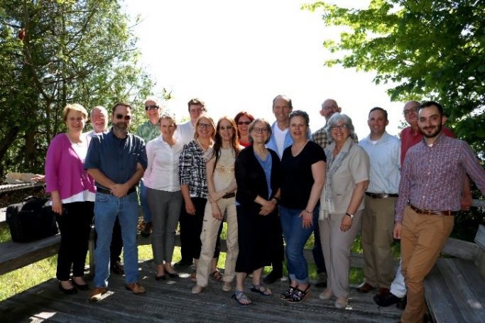
DRAFT for public consultation                                                                      February 7, 2022

Figure 3. Spring water
levels at Rouse's Point, New
York during Lake
Champlain major floods,
1990-2019 4

The floods that have
occurred over the
past century have often resulted in studies and recommendations of mitigation measures. For example,
in the 1930s, the implementation of a dam project in the Richelieu River was recommended.
Construction was initiated not far from what is now known as the Fryers Island Dam, about 9 km (5.6 mi)
downstream of Saint-Jean-sur-Richelieu, Quebec, and excavation upstream of the shoal was started.
However, work was halted at the outbreak of World War II, and the dam project was never completed.
A study in the 1970s suggested construction of a gated structure in the river at Saint-Jean-sur-Richelieu,
but such a structure did not receive political support in the United States. This study also recommended
flood forecasting, implemented in the United States first and in Canada much later, and flood plain
mapping, which was carried out in both countries. Other policy actions were also taken to reduce flood
damages. Although there have been prior studies and recommendations regarding flooding in the basin,
they have been limited in their ability to address the problem. Further, there are concerns that the
magnitude, frequency and economic severity of flooding could increase over time due to a changing
climate and development in the floodplain.

In the spring of 2011, the region experienced flooding well beyond anything seen over the last century.
Lake Champlain's water levels far exceeded the previous historical maximum level. The Richelieu River
rose above flood stage for more than two months. Many farms and an estimated 4,000 homes along the
Richelieu River in Québec and along the shoreline of Lake Champlain were damaged (Figure 4). More
than 40 communities were directly affected, and thousands of residents needed to be evacuated. While

4
  Flood Management and Mitigation Measures Technical Working Group and Hydrology, Hydraulics, and Mapping
Technical Working Group (FMMM/HHM), 2021. Potential Structural Solutions to Mitigate Flooding in the Lake
Champlain-Richelieu River Basin. International Lake Champlain – Richelieu River Study. A report to the International
Joint Commission. https://ijc.org/en/lcrr/potential-structural-solutions-mitigate-flooding-lake-champlain-richelieu-
river-basin
                                                                                                                  7
Study findings and recommendations as of January 28, 2022; subject to change. The final report is scheduled for
release in April 2022.
DRAFT for public consultation                                                                    February 7, 2022

damages had previously been estimated at more than CDN$110 million (US$82 million) 5, this
assessment included primarily recorded residential damages, and not a broader set of impacts. A more
comprehensive evaluation conducted with the Study’s Integrated Social, Economic and Environmental
System (ISEE) indicated that damages were about 70 percent higher, or about CDN$188 million (US$141
                                                                           million) 6.

                                                                                    Figure 4. 2011 flooding,
                                                                                    Colchester, Vermont (Photo
                                                                                    credit: Matt Sutkoski)

The catastrophic 2011 flood was a new call to action and led the governments of Canada and the United
States to request that the International Joint Commission (IJC) undertake a study into the causes,
                                                                  impacts, risks and solutions to flooding
                                                                  in the LCRR basin. The IJC is a
 The Study Board will make recommendations for                    binational treaty organization whose
 consideration by the International Joint Commission and          focus is to protect the waters shared
 the Canadian and US governments; the governments make            by Canada and the United States,
 final decisions regarding whether recommendations will be
                                                                  working toward solutions that are for
 implemented.
                                                                  the common good of both countries.

5
  International Lake Champlain and Richelieu River Study Board (ILCRRSB), 2019. The Causes and Impacts of Past
Floods in the Lake Champlain-Richelieu River Basin: Historical Information on Flooding. A Report to the
International Joint Commission. https://ijc.org/en/lcrr/causes-and-impacts-past-floods-lake-champlain-richelieu-
river-basin-historical-information
6
  Flood Management and Mitigation Measures Technical Working Group and Hydrology, Hydraulics, and Mapping
Technical Working Group (FMMM/HHM), in preparation. Evaluation of Potential Structural Solutions in the
Richelieu River to Mitigate Extreme Floods
                                                                                                                   8
Study findings and recommendations as of January 28, 2022; subject to change. The final report is scheduled for
release in April 2022.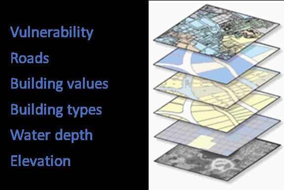
DRAFT for public consultation                                                                        February 7, 2022

What has the IJC done to try to find solutions?
As mentioned above, the IJC was called upon previously to look into major flood events in the 1920s and
1970s. The current study reflects the call to action resulting from the spring 2011 flooding in the basin.
In the spring of 2012, The governments of Canada and the United States asked the IJC to draft a plan of
study to examine the causes and impacts of the 2011 flooding and develop possible mitigation
measures. In the fall of 2014, a second mandate from the governments requested the collection of data,
development of tools and creation of static floodplain maps. In 2016, the governments instructed the IJC
to carry out activities described in the plan of study, leading the IJC to establish the Lake Champlain –
Richelieu River Study Board. The Study Board oversees the Lake Champlain-Richelieu River Flood Study,
which is an international collaboration involving individuals with expertise in engineering, flood
management, planning and mitigation, as well as economics and social sciences. The inclusion of a team
to study, from the onset, the social, political and economic drivers associated with flood mitigation is
new to IJC studies and will provide useful insights for other studies in the future.

The Study has explored the causes, impacts, risks and solutions to flooding in Lake Champlain and the
Richelieu River 7. To do so, a framework was adopted for the Study that includes consideration of a
variety of structural and non-structural 8 measures. The Study Board’s flood mitigation framework
focuses on four key mitigation themes:

Structural:

    1. Reduce high water levels on the Richelieu River and Lake Champlain
    2. Impede inflows into Lake Champlain or the Richelieu River through wetland and temporary
       upstream storage of floodwaters.

Non-structural:

    3. Improve flood response (flood forecasting and emergency preparedness).
    4. Enhance floodplain management (adaptation to flooding).

Experts identified, developed and evaluated potential flood mitigation measures under each of the four
themes. Theme 1 focused on the development of moderate structures that lowered flood peaks, while
Theme 2 evaluated the effectiveness of storing floodwaters within the watershed. In Theme 3, new
state-of-the-science flood forecast models were developed, and Theme 4 explored new approaches to
flood risk communication and flood insurance. Evaluations of ways to mitigate flooding and its impacts
in the LCRR basin included developing and using sophisticated computer models to understand and

7
  The Study focuses on the reduction of flood impacts on the Richelieu River and Lake Champlain and does not
directly address the reducing flooding and the impact of flooding on tributaries, although the impacts of more
localized tributary flooding are recognized as often severe and relatively frequent.
8
  Non-structural measures differ from structural measures in that they focus on reducing the consequences of
flooding instead of reducing the probability of flooding (they generally cause no changes to flood levels, velocities,
duration, or the environment.) Non-structural measures can be temporary (contingent) or permanent.
                                                                                                                     9
Study findings and recommendations as of January 28, 2022; subject to change. The final report is scheduled for
release in April 2022.
DRAFT for public consultation February 7, 2022
simulate floods and flood impacts developing proposed mitigation solutions, and evaluating the
acceptability of potential mitigation approaches. The Study developed a powerful tool, the Integrated
Social, Economic and Environmental System (ISEE) to assist in understanding flood risk and evaluating
potential solutions (Figure 5). ISEE can produce a variety of flood impact maps tailored to support an
assessment of the possible mitigation measures. Other methods and models were used by various
experts to answer specific questions such as those related to upland storage capacity or the potential
effects of climate variability on flood adaptation strategies.
Figure 5. Integrated Social, Economic and
Environmental (ISEE) System for assessing flood
risk
To integrate social, political and
economic considerations, social
scientists used various methods such as
conducting focus groups and surveys of
the general public, emergency
managers and planners, and elected
officials to gauge risk perception,
sources of risk communication and flood mitigation behaviors. Matters such as technical feasibility, cost,
environmental impact and public preferences of specific structural changes were taken into
consideration. Through these activities, the experts were able to understand how the public in each
region of the basin perceived the risk of lake and riverine flooding, the anticipated impacts on their
livelihoods, and their willingness to adopt certain risk mitigation measures and policies, as well as how
they received risk communication messages.
For example, scientists found that, for many stakeholders, lake and river flooding are higher priorities in
Quebec than in the United States. Stakeholders in both Canada and the United States place the highest
priorities on protecting human health and safety, and support flood preparedness and adaptation
measures, as well as nature-based solutions, over large structural interventions.
The Lake Champlain and the Richelieu River basin served, and continues to serve, as a resource for food,
water, tools and spiritual practices for Indigenous peoples. Hunting, gathering, fishing, boating and
recreation are important activities. There are cultural and archeological sites (campsites, villages,
meeting sites, burial sites) of traditional and sacred importance to the Indigenous people across the
basin. As such, the Study reached out to Indigenous communities with an interest in flood remediation
in the basin and started a dialogue to make certain that the Study Board heard their concerns about
cultural resources and practices that were impacted by past and present flooding in the basin. New
10
Study findings and recommendations as of January 28, 2022; subject to change. The final report is scheduled for
release in April 2022.DRAFT for public consultation February 7, 2022
knowledge was also incorporated into the indicator work, helping to ensure that the various flood
mitigation measures considered took into account potential impacts on Indigenous communities. The
dialogue continues during this consultation period.
Public and stakeholder engagement is an essential and ongoing component of the LCRR Study and
includes both direct engagement by the Study Board (for example through public meetings) as well as a
close collaboration with the Public Advisory Group (PAG). The binational PAG (Figure 6) represents
various areas of interest within the Lake Champlain-Richelieu River basin. Its members drew on their
knowledge, contacts and experience to provide advice and to encourage public participation in the
Study by:
• Advising the Study Board on public consultation, involvement and information exchange;
• Serving as a conduit for public input to the Study process, and sharing Study outcomes;
• Reviewing and providing feedback on approaches, reports, products, findings and conclusions of
the Study Board; and
• Recommending to the Study Board how to effectively meet the concerns of the public and
stakeholders.
Figure 6. Members of the Public Advisory Group
Over the last two years, Study scientists increased their efforts to share research findings with the public
through technical webinars and other public engagements. Members of the PAG and participants in
surveys, focus groups, meetings, and workshops were key to the work of Study experts and the LCRR
Study Board, and these contributions are greatly appreciated. Reports, videos, fact sheets and white
papers on key aspects of the Study have been published on the Study website (www.ijc.org/lcrr), and a
Study newsletter, The Current, was distributed on a bimonthly basis. Outreach coordinators played a key
role in the multiple stakeholder and public meetings held throughout the Study.
The overall objective of these science and outreach activities was to develop a variety of potential flood
mitigation measures and strategies that take into account technical, environmental, social and economic
factors.
11
Study findings and recommendations as of January 28, 2022; subject to change. The final report is scheduled for
release in April 2022.DRAFT for public consultation February 7, 2022
What should be done in the future?
Under the four Study themes, measures were identified that decrease flooding and its impacts and
increase the resilience of lake and river communities to future high-water events. In conjunction with
analysis of potential mitigation measures for the four primary themes, the Study examined future
variability of water supplies under a changing climate, combining measures for greater impact, and
enhancing binational collaboration.
Analysis of promising measures
Teams of experts from both Canada and the United States considered a range of potential measures to
reduce flooding and its impacts. Promising measures were considered in light of the Study Board’s
mandate and decision criteria and provide the basis for the Board’s recommendations.
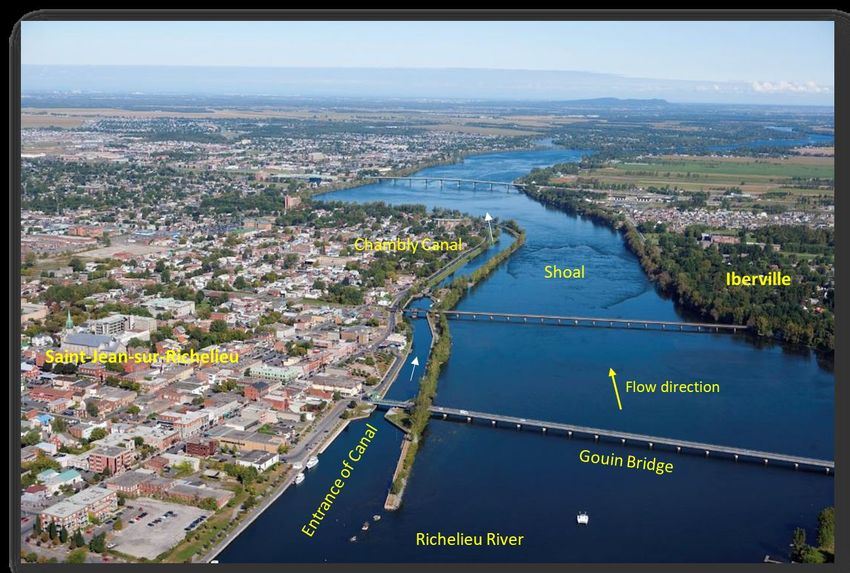
Theme 1: Reduce water levels during flood events by structural measures
The Saint-Jean Shoal is the natural control point for water levels in the LCRR system. This
means that it acts somewhat like a bottleneck for water flow, influencing water levels
upstream (see Figure 7). To decrease maximum flood levels in the lake and alongside the
river upstream of this point, accelerating the passage of water through this section would be key.
Figure 7. Aerial view of the Richelieu River at Saint-Jean-sur-Richelieu, looking downstream
Study scientists initially identified seven potential structural measures and assessed their effectiveness
12
Study findings and recommendations as of January 28, 2022; subject to change. The final report is scheduled for
release in April 2022.DRAFT for public consultation February 7, 2022
at reducing extremely high water levels, while sustaining water levels in the lake during low flow. These
potential measures included various combinations of: selective removal of human-built structures to
increase flow across the Saint-Jean shoal, diverting flow through the Chambly Canal along the side of the
shoal, installing a fixed weir (submerged dam) upstream of Saint-Jean-sur-Richelieu, and installing an
inflatable weir or bladder either upstream of Saint-Jean-sur-Richelieu or at the shoal. For each potential
structural measure considered, study scientists conducted an initial assessment using the available
information and data to determine whether it warranted further evaluation.
The Study was requested by the IJC not to consider major structural works and to focus on “moderate
structural works.” This eliminated further consideration of measures that involved the damming of the
river (fixed or inflatable weirs). The unsuccessful history of trying to implement a dam on the river
indicated a lack of support for a flood control structure of this size. The Study, therefore, focused its
attention on measures involving selective removal of material from the river and diversion of water
through the Chambly Canal, as these are moderate structural solutions. Specifically, three structural
measures were explored in detail:
1. Selective excavation of the Saint-Jean-sur-Richelieu Shoal to remove human-made features and
other selected areas of higher elevation on the shoal that act as a bottleneck, with a submerged
weir to help moderate flow and avoid low water levels during dry periods
2. Diversion of significant flow (400 m3/s) through the Chambly Canal during flood events to move
water downstream more quickly to decrease water levels
3. Diversion of a moderate amount of flow (80 m3/s) through the Chambly Canal, in conjunction
with Measure 1 (selective excavation and submerged weir)
Analysis of the measures included assessment of technical feasibility, mapping natural and modified
riverbed elevations, simulations of flow impacts and benefits associated with structural measures,
development of thorough cost estimates, and exploration of potential operating plans. The analysis of
these alternatives was conducted to provide a proof-of-concept design and it is recognized that
additional work (e.g., detailed engineering plans, environmental impact assessment, etc.) would be
required to implement any of these alternatives.
The diversion of a significant amount of water through the Chambly Canal (Measure 2) was examined by
a technical committee, and both technical and economic problems were identified with this measure;
Measure 2 is therefore not recommended.
13
Study findings and recommendations as of January 28, 2022; subject to change. The final report is scheduled for
release in April 2022.DRAFT for public consultation February 7, 2022
Findings and recommendations:
The Study identified two promising structural measures that meet the evaluation criteria 9.
The structural solutions under consideration help return the Richelieu River to a more
naturalized state of its hydraulic regime by removing some of the human modifications and shoal
materials that impede river flow. This hydraulic regime provides lower water levels during floods
compared to the current state, resulting in reduced damages in both the United States and Canada. It
also includes the added benefit of keeping water levels higher during dry periods. The suggested
measures show favorable financial benefits compared with the costs (Table 1), and neutral or positive
environmental impacts for most key species or habitats considered in the review.
Table 1. Assessment of costs and benefits of structural measures
Selective removal of shoal Selective removal of shoal
material + submerged weir material + submerged weir +
moderate Chambly Canal
diversion
Economic assessment
Cost CDN $8M (US$6.4M) CDN$21M (US$16.8M)
Benefit/cost ratio (Canada only) 10.11 3.96
Water level assessment
Decrease in Richelieu River level 15.2 cm (6.0 in) 22.3 cm (8.8 in)
for 2011 flood
Decrease in Lake Champlain 10.7 cm (4.2 in) 15.2 cm (6.0 in)
level, 2011 flood
Increase in Lake Champlain Up to 28.0 cm (11.0 in) Up to 28.0 cm (11.0 in)
Level, 1965 drought
Impact assessment
Homes saved from flooding, 596 (15.5%) 928 (24.2%)
2011 flood
The first promising structural measure combines the first two of the three elements below; the second
solution includes all three of the following elements:
• Selective removal of material from the shoal in the Richelieu River at Saint-Jean-sur-Richelieu,
including removal of unused human structures (submerged dikes and an ancient, not visible eel
trap 10) that remain in the river, to promote faster flow through this section.
9
Flood Management and Mitigation Measures Technical Working Group and Hydrology, Hydraulics, and Mapping
Technical Working Group (FMMM/HHM), in preparation. Evaluation of Potential Structural Solutions in the
Richelieu River to Mitigate Extreme Floods
10
The highly visible eel trap that is a landmark for the community will not be removed
14
Study findings and recommendations as of January 28, 2022; subject to change. The final report is scheduled for
release in April 2022.DRAFT for public consultation February 7, 2022
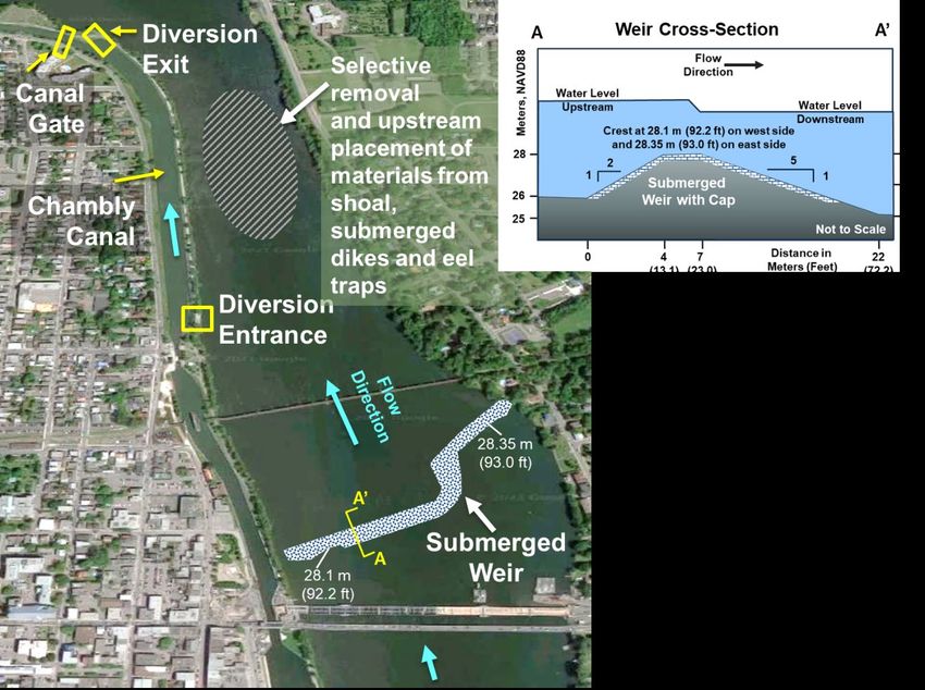
• Reshaping of the eastern side of the upper shoal and construction of a submerged weir, using
the excavated material, to keep the water levels in the upper river and lake from dropping too
low during dry periods as a result of the shoal excavation.
• Creating box culverts and gates that would allow some river flow to be diverted through dikes
into and out of a segment of the Chambly Canal between locks and adjacent to the narrowest
part of the shoal; this would allow extra water to pass through this constricted area more
quickly during flooding events. The diversion would be initiated when the water level reaches
29.25 m (95.96 ft).
These elements are shown in Figure 8. A key advantage of the submerged weir is that it can be
constructed using the excavated materials, greatly reducing construction costs and providing a more
natural substrate for aquatic life. The weir will not be visible except at extreme low flows, and it can be
repaired or modified as needed in the future.
Figure 8. Schematic diagram of proposed excavation, weir construction and diversion through Chambly Canal at Saint-Jean-sur-
Richelieu shoal
15
Study findings and recommendations as of January 28, 2022; subject to change. The final report is scheduled for
release in April 2022.DRAFT for public consultation February 7, 2022
Recommendations
The Study Board recommends the IJC advise governments that it is possible to
achieve a modest relief of flood (on the order of 10 cm on the Lake and 15 cm at Saint-Jean-sur-
Richelieu for an event like the 2011 flood) and drought water levels by returning the hydraulic
regime at the Saint-Jean-sur-Richelieu shoal to a more naturalized hydraulic state. This can be
achieved by removing some flow-impeding human artifacts in addition to some selected
excavations of the shoal and installing a submerged weir in the area of the Saint-Jean-sur-
Richelieu shoal. From the Study’s evaluation of the proofs of concept, this moderate structural
solution is technically feasible, economically beneficial, and socially acceptable. Also, based on
the Study's analysis with environmental performance indicators, it appears that the structural
solution has positive environmental impacts and no significant negative environmental impacts.
If desired, additional flood relief can be gained through combining the removal of the artifacts,
selected excavations of the shoal, and the submerged weir with a modest water diversion
through the Chambly Canal (for a total water level reduction of 15 cm on the Lake and 20 cm at
Saint-Jean-sur-Richelieu for an event like the 2011 flood). While this alternative that includes
the Chambly Canal water diversion is less economically performant, this addition brings greater
water level relief for larger flood events and should be presented to the governments for their
considerations.
If the governments decide to implement a structural solution, a process should be put in place
to analyze binational social, political, environmental and economic implications of the final
structure design and operation.
Theme 2: Impede flow by increasing watershed storage to reduce flooding
Another way to reduce high water levels is to slow the entry of water into the Lake and
River by storing water on the land or using other nature-based solutions. The study
looked at (i) quantifying the flood reduction of existing wetlands (about 1,551 square kilometers or 599
square miles) (ii) quantifying the flood reduction impact of increasing wetlands of tributaries in Vermont
and New York subwatersheds and (iii) assessing the potential of temporarily storing floodwater on
riparian agricultural landscapes 11.
11
Rousseau, A., S. Savary, M-L. Bazinet, 2021. Flood water storage using active and passive approaches – Assessing
flood control attributes of wetlands and riparian agricultural land in the Lake Champlain-Richelieu River watershed.
2019-2020. A report to the International Lake Champlain-Richelieu River Study Board
https://ijc.org/sites/default/files/LCRR_Watershed_Storage_Report_EN_01142022.pdf
16
Study findings and recommendations as of January 28, 2022; subject to change. The final report is scheduled for
release in April 2022.DRAFT for public consultation February 7, 2022
Quantification of potential flood reduction was accomplished using a hydrological modelling platform,
which subdivided the watershed into river segments and hillslopes, simulated the effect of land cover on
flows, and provided input to a lake/reservoir water balance model and a model to predict lake or river
water levels.
This assessment of the hydrological services provided by the existing wetlands (1,551 km2 or 599 mi2)
located in the Lake Champlain basin indicated that for a flooding event of the magnitude of the 2011
flood, existing wetlands can reduce the Lake Champlain water level by 15 cm (5.9 in), the Richelieu River
peak flow by 6.7 percent, and the Richelieu River water level by 12 cm (4.7 in). Also, existing wetlands
stabilize low flows during droughts. It is therefore important that existing wetlands be preserved and
protected.
In addition to evaluating existing wetlands, the study evaluated several scenarios involving increasing
wetlands of tributaries in Vermont and New York subwatersheds (Figure 9), as well as temporarily
flooding agricultural lands to store floodwaters. Adding 1,488 km2 (575 mi2) of wetland area (would
provide additional flood relief, as shown in Table 2. The effect of temporarily flooding farmlands (2,256
km2 or 871 mi2) would provide some flood relief, but the water level reductions are lower than for
adding wetlands.
Table 2. Effect of adding 1,488 km2 of wetland in the Lake Champlain basin on high water levels in Lake Champlain and the
Richelieu River
Lake Champlain Richelieu River
Average high-water reduction 8 cm (3.1 in) 6 cm (2.4 in)
Reduction for 2011 flood 12 cm (4.7 in) 10 cm (3.9 in)
Findings and recommendations
The Study demonstrated that existing wetlands provide significant flood relief, and the 2011
floods would have been much worse in the absence of these wetlands. For this reason, it is
important that existing wetlands be preserved and protected. From a strictly technical
perspective, additional wetlands could contribute to flood attenuation by passive water storage.
However, adding wetlands and flooding farmland would require extensive land alteration and
acquisition. Given existing policies, programs, and regulations in Canada and the United States, restoring
and constructing new wetlands instead of flooding farmland would provide a socially-acceptable
framework to build resilience over time in the basin, at least at the local subwatershed scale. Expanding
wetlands to provide substantial flood relief for Lake Champlain and the Richelieu River, however, was
determined to require a very large land area (about the size of Lake Champlain). The Study Board’s
preliminary benefit/cost evaluation suggested about $100 of cost for every $1 of benefit for reducing
water levels at the basin scale. This measure is therefore not practical to implement, and is not a viable
solution to major flooding in Lake Champlain and the Richelieu River.
17
Study findings and recommendations as of January 28, 2022; subject to change. The final report is scheduled for
release in April 2022.DRAFT for public consultation February 7, 2022
Figure 9. Areas of potential wetland storage
(shown in dark blue)
18
Study findings and recommendations as of January 28, 2022; subject to change. The final report is scheduled for
release in April 2022.DRAFT for public consultation February 7, 2022
Recommendations
The Study Board recommends that the IJC encourage the governments to continue
protection of existing wetlands, as they provide flood relief (reduction of the peak water level by
15 cm in Lake Champlain and 12 cm in the Richelieu River during a 2011-scale flood) at the scale of
lakeshore and Richelieu riverfront communities.
The Study Board recognizes that wetlands reduce local tributary flooding, support biodiversity, and
have important environmental co-benefits. Consequently, the Study Board wishes to encourage
governments to continue to protect these existing wetlands and, where possible, to restore lost
wetlands and create new ones.
However, the LCRR Study has determined that without the creation of a very large area of new
wetlands, there cannot be significant flood mitigation at the scale of lakeshore and Richelieu
riverfront communities during major flood events. Therefore, the Study Board does not
recommend pursuing a strategy for acquiring land and creating new wetlands as a flood
management policy for lakeshore and Richelieu riverfront communities.
Theme 3: Respond to floods with better forecasts and planning to enhance resilience
Besides evaluating solutions that concern reducing high water levels, the Study
considered a second goal: to reduce vulnerability to flooding and build flood resilience
through improved preparedness.
Study activities related to improved forecasts and emergency planning fall into two areas:
• Improving flood forecasts and flood hazard mapping
• Exploring mapping flood impacts for emergency responses
Improving flood forecasts and flood hazard mapping
The Study evaluated flood forecasting systems in Quebec and the United States 12. Flood forecasting
relies heavily on the evolution in space and time of meteorological conditions such as temperature,
liquid and frozen precipitation and solar radiation. In this context, the National Oceanographic and
Atmospheric Administration (NOAA) in the United States and Environment and Climate Change Canada
12
Flood Management and Mitigation Measures Technical Working Group and Hydrology, Hydraulics, and Mapping
Technical Working Group (FMMM/HHM), in preparation. Development of a Binational Flood Forecasting and Real-
time Floodplain Mapping System for Operational Implementation
19
Study findings and recommendations as of January 28, 2022; subject to change. The final report is scheduled for
release in April 2022.DRAFT for public consultation February 7, 2022
(ECCC) in Canada operate numerical weather prediction systems ranking amongst the best in the world;
this information is made available through an open data portal to the respective agencies responsible
for the production and dissemination of flood forecasts, guidance and warnings.
In the United States, NOAA is the sole federal authority providing flood forecasts, guidance and
warnings. In Canada, the provision of flood forecasts, guidance and warnings is a provincial
responsibility. For the northern portion of the LCRR watershed, located in the Province of Québec, the
responsible authority is the Ministère de l’Environnement et de la Lutte contre les Changements
climatiques 13 (MELCC). Each agency is responsible for issuing official flood forecasts for its respective
territories and producing coherent binational forecasts for the LCRR; there is no single binational official
flood forecast. Experts have reviewed the programs and indicated that independent flood forecasts will
continue to be used in the recommended flood forecasting system in the future. However, the various
components (i.e., models) should continue to be deployed within ECCC, NOAA and MELCC in a
collaborative manner.
Improvements in many components have occurred during the LCRR Study. In the United States,
improved hydrologic models have been created for the LCRR basin; these modeling improvements
increase the ability to produce flooding forecasts for the tributaries to Lake Champlain. A new
experimental forecast system (Figure 10) produces forecasts of spatially variable lake level, circulation
and wind waves in Lake Champlain and the Richelieu River system to provide a proof of concept of what
advance warning of floods in the region can look like.
13
Ministry of the Environment and the Fight Against Climate Change
20
Study findings and recommendations as of January 28, 2022; subject to change. The final report is scheduled for
release in April 2022.DRAFT for public consultation February 7, 2022
Figure 10. Example of flood forecasting improvements undertaken for Lake Champlain
An assessment of user needs highlighted that desired forecasting products include short-term
inundation maps with associated probabilities of occurrence or exceedance of flooding limits, as well as
long-term water level and flow graphs assessing the flood risk with ranges of probabilities. The
recommended flood forecasting system will use the models (or similar ones) developed or improved
during the LCRR Study that can capture the processes relevant to forecasting on the LCRR, such as
winter snow accumulation and projected timing and volume of snowmelt, inflows to Lake Champlain,
discharge through the Richelieu River, and effects of wind and waves on the system. These individual
models and the coordinated use of groups of models in forecasting (ensemble forecasting) will support
uncertainty assessment and inundation mapping with forecasts, as desired by users.
Explore mapping flood impacts for emergency responders
The Study looked at tools that could go beyond providing information on flood hazard (extent of flood
and depth of water) to help local emergency responders prepare for upcoming flooding. The Study used
the Integrated Social, Economic and Environmental system (ISEE) to evaluate flood risk beyond hazard
(Figure 11). ISEE incorporates social risk such as vulnerability and can generate maps and information,
such as extent of flood, depth of water, road access and location of people at risk, that can improve
emergency responses to floods. One of the key features is that it provides information at a very high
level of granularity (for example, for a given building, road or property), which can be very helpful for
both emergency response and also for planning over a longer period of time.
21
Study findings and recommendations as of January 28, 2022; subject to change. The final report is scheduled for
release in April 2022.DRAFT for public consultation February 7, 2022
Figure 11. Integrated Social, Economic and Environmental (ISEE) mapping tool
22
Study findings and recommendations as of January 28, 2022; subject to change. The final report is scheduled for
release in April 2022.DRAFT for public consultation February 7, 2022
Findings and recommendations
The study explored some potential improvements in modeling and forecast products.
Operational agencies such as NOAA, ECCC and MELCC will have access to all of the tools
developed in the Study. This will be helpful for them to increase forecast lead time to five
days and to include inundation mapping in their operational systems such as the NOAA National Flood
mapping initiative and the Quebec Info-Crue project that is underway. These tools will support
individuals, communities and first responders in developing flood response plans.
Gap analysis of the current situation compared with the recommended system found that the required
models are very close to ready for use, but still require some work to connect better with each other
and to be deployed in operations. The work is on the right track and no major technical barriers exist.
Some research is still required to find a proper integration methodology for multiple forecasts, but a
hands-on approach by the forecasters can be leveraged in the meantime. The Study Board considers it
important that the supporting agencies maintain their current collaboration and readily provide the
required data to each other to maintain the forecasting chain.
23
Study findings and recommendations as of January 28, 2022; subject to change. The final report is scheduled for
release in April 2022.DRAFT for public consultation February 7, 2022
Recommendations
The Study Board recommends that all of the weather and hydrological information
generated by NOAA (in the United States) and ECCC and MELCC (in Canada) be made available to and
used by the respective agencies responsible for the production and dissemination of flood forecasts,
guidance and warnings.
• Continuation and enhancement of the collaboration between the various Agencies, namely
NOAA, ECCC and MELCC, must be encouraged to ensure all available forecast data and their
interpretations are shared in real time, with the ultimate goal that the official forecasts on
each side of the border are of the highest possible quality and are accompanied by a concerted
and consistent cross-border interpretation.
• Improved modelling and forecasting tools developed for the Lake Champlain-Richelieu River
basin can greatly aid flood response planning and should be maintained. They showed the
possibility of extending the forecasting horizon and providing new operational products
relevant to the basin’s stakeholders, such as water set-up, waves, flood extent and depth, and
their consequences on the shore, for example: roads cut off, social vulnerabilities, and
monetary impacts.
On that basis, the governments are encouraged to operationalize the improved modelling and
forecasting tools and coherent risk assessment systems and support/maintain them after the Study.
The LCRR tools, supporting data and documentation should be transferred to appropriate agencies in
Canada and the US by no later than the end of 2022.
To support flood preparedness, simulations of flooding of various magnitudes and the related maps
produced should be made available to all interested parties by no later than the end of 2022.
Theme 4: Floodplain management practices to enhance resilience
Under this theme, the Study sought non-structural approaches to increase the resilience
of lakeshore and riverfront communities to flooding through floodplain management.
These measures involve implementing a range of policy tools that prevent and reduce
flood hazards, limit flood exposure and decrease social vulnerability to flood impacts, improving the
general well-being of residents.
Flood risk is the product of three elements: (1) a flood hazard, meaning inundation by water of land that
is normally dry; (2) the exposure of people, property, infrastructure, and economic activity in or near the
flood hazard zone; and (3) the vulnerability of people and assets to harm from flooding.
24
Study findings and recommendations as of January 28, 2022; subject to change. The final report is scheduled for
release in April 2022.DRAFT for public consultation February 7, 2022
25
Study findings and recommendations as of January 28, 2022; subject to change. The final report is scheduled for
release in April 2022.DRAFT for public consultation February 7, 2022
The Study has produced information and tools to support the implementation of a flood risk
management strategy. These will be important tools available after the Study is completed, and include:
• Flood forecasts and flood hazard maps that can be used by regional and local emergency
managers to plan for preparedness and response;
• Climate Change scenarios and a decision approach to support decision making in the face of
uncertainty;
• An Integrated Social, Economic, and Environmental (ISEE) modeling system, which provides
localized estimates of flood damages to buildings and homes to evaluate the costs and benefits
of risk reduction investments in the basin; and
• Assessments of the political feasibility and social acceptability of policy tools, including
documenting support among emergency managers and planners, prioritization of equity in the
distribution of benefits and costs, and integration of flood risk information into comprehensive
land use plans and zoning regulations.
On the specific topic of Floodplain Management, four key areas of focus were each addressed by the
development of a corresponding topical White Paper 14:
• Flood maps
• Flood risk communication
• Floodplain occupancy management
• Flood insurance.
Best management practices compiled in these White Papers, based on a literature review and interviews
with experts, were synthesized into a summary report for the floodplain management theme 15.
14
White papers in preparation; citations to be added
15
Integrative White Paper in preparation; citation to be added
26
Study findings and recommendations as of January 28, 2022; subject to change. The final report is scheduled for
release in April 2022.DRAFT for public consultation February 7, 2022
Findings and recommendations
The Study finds that an effective flood risk management strategy should:
• be based on a comprehensive and continuous assessment of flood risk (i.e., hazard,
exposure, and vulnerability);
• implement a portfolio of risk reduction tools to avoid, accommodate, and retreat from flood
risk; and
• openly communicate flood risk to stakeholders and the public.
Drawing on the four White Papers produced under this theme, the Study identified four key policy tools
that could be applied to reduce flood risk:
• Flood maps: These are a valuable resource for flood risk management, but they should be
designed to target specific audiences, such as planners or the general public. Maps designed for
public use should be dynamic, interactive, and user-friendly to achieve their full potential.
• Flood risk communication campaigns: Other than simply informing targeted audiences about
their flood risk and actions they can take to reduce the risk, communication campaigns could
also be used in this watershed to increase purchasing of flood insurance by at-risk property
owners, encourage local emergency management, and inform potential buyers of at-risk
properties, but messages should be designed using best practices.
• Floodplain management: This includes discouraging occupancy of flood-prone lands due to
current risk and in anticipation of changes in future risk. However, existing development also
faces flood risk, which should be reduced through temporary or permanent protections and
building alterations whenever justified.
• Flood insurance: Insurance can be an effective tool to speed post-flood recovery, but securing
widespread coverage will require sharing risk and responsibility between government and the
private sector.
Those findings and reviews of best practices should be taken to the cognizance of appropriate level of
governments in US and Canada as relevant information for them to analysis for their flood risk
management activities in the LCRR.
The Study has produced a wealth of data and tools to support flood risk management in the LCRR basin:
• The Study has supported an enhanced flood forecasting system, including several models, that
will enable real-time forecasts of lake levels, wave heights and river levels, to assist in planning
for preparedness and response.
• The Study’s “decision scaling” approach that incorporates uncertainty in climate change
projections will aid in prioritizing risks and refining adaptation options.
• The ISEE system is a sophisticated tool to evaluate flood risk at the property level and estimate
flood damages under varying water levels. This tool can be used to compare the costs and
benefits associated with various potential mitigation measures.
• The study provides context for understanding the political feasibility and social acceptability of
27
Study findings and recommendations as of January 28, 2022; subject to change. The final report is scheduled for
release in April 2022.You can also read