SYNOPTIC CHARACTERISTICS OF AN EXTREME WEATHER EVENT: THE TORNADIC WATERSPOUT IN TIVAT (MONTENEGRO), ON JUNE 9, 2018 - RCIN
←
→
Page content transcription
If your browser does not render page correctly, please read the page content below
Geographia Polonica
                    2021, Volume 94, Issue 1, pp. 69-90
                    https://doi.org/10.7163/GPol.0194

                                                              INSTITUTE OF GEOGRAPHY AND SPATIAL ORGANIZATION
                                                                                   POLISH ACADEMY OF SCIENCES
                                                                                                www.igipz.pan.pl
                                                                                      www.geographiapolonica.pl

SYNOPTIC CHARACTERISTICS OF AN EXTREME
WEATHER EVENT: THE TORNADIC WATERSPOUT
IN TIVAT (MONTENEGRO),
ON JUNE 9, 2018
Jovan Mihajlović1                  • Dragan Burić2              • Vladan Ducić1 • Milan
Milenković3
1
    Faculty of Geography
    University of Belgrade
    Studentski trg 3/3, 11000 Belgrade: Serbia
    e-mails: millennijum@hotmail.com • vladanducic@yahoo.com
2
    Faculty of Philosophy, Department of Geography
    University of Montenegro
    Danila Bojovica bb, 81400 Nikšić: Montenegro
    e-mail: dragan.buric@meteo.co.me (corresponding author)
3
    Geographical Institute “Jovan Cvijić“
    Serbian Academy of Sciences and Arts
    Djure Jakšića 9, 11000 Belgrade: Serbia
    e-mail: milenkovic011@gmail.com

Abstract
Recently Montenegro has often been faced with extreme weather events. The aim of this paper is to provide
a detailed synoptic analysis of a severe weather event, a waterspout, and to confirm an indication that
in most cases such events could potentially be forecasted, which is of great practical significance, since
human lives and property can be saved. The paper presents the research results of synoptic and mesoscale
weather conditions which created a favourable meteorological environment for a waterspout development
in Tivat (Montenegrin coast) on June 9, 2018, around 01 UTC (03 CET). Based on field survey analysis,
the rating of tornado intensity by the Fujita scale (F-scale) has been done by assessing the damage. The syn-
optic type for this situation was CLOSED-SW and was determined by a detailed examination of atmospheric
circulation. The results presented in the manuscript can help decision makers in Montenegro to take certain
adaptation measures (above all, in tourism and construction) in order to mitigate the negative consequences
of weather extremes.

Key words
extreme weather • waterspout • synoptic conditions • Tivat • Adriatic Sea • Montenegro
70                                                                              Jovan Mihajlović et al.

Introduction                                          there is a yearly average of 16 waterspouts
                                                      over the Adriatic Sea.
Although waterspouts are most common                      However, Renko et al. (2016) pointed
in the southeastern United States (Florida            out that waterspouts had been more often
Keys) and parts of the Mexican Gulf (Ros-             recorded over the Eastern Adriatic coast
sow, 1970; Golden, 1977), these extreme               during the last decade. According to their
local storms are a global phenomenon (Snow,           research work, 359 waterspouts in 150 days
2020), and were also registered in vari-              were recorded in the period 2001-2013 over
ous parts of the Mediterranean, most often            the Eastern Adriatic coast (a waterspout day
in the summer and autumn seasons (Siou-               is a day with at least one recorded water-
tas & Keul, 2007). The process of formation           spout). After the year 2005, there were
of this extreme weather phenomenon, as well           20 recorded waterspouts per year, and the
as its duration and spatial coverage, has             maximum number was recorded exactly
been described in many papers (e.g. Huschke,          at the end of the observed period. 104 water-
1959; Browning, 1964; Golden, 1974; Brady             spouts were recorded in 2013, most of them
& Szoke, 1988; Hagemeyer, 1994; Davies-               in the vicinity of Dubrovnik (39 waterspouts).
Jones et. al., 2001; Mihajlović et al., 2016).        Dubrovnik is a city located in Croatia, rela-
    Considering the waterspout climatology            tively close to Tivat, about 50 km away.
in Europe, Dotzek (2001; 2003) suggests               The highest number of waterspouts has been
that 160 waterspouts on the average are               recorded in summer months, particularly dur-
recorded in Europe annually. There are                ing August. Nevertheless, the authors point
research papers dealing with the waterspout           out that the increase in waterspout frequen-
climatology in the Mediterranean region               cy cannot be exclusively explained by the
(Peterson, 1998; Penzar et al., 2001; Holzer,         change of meteorological environment,
2001; Sioutas & Flocas, 2003; Gianfreda               but also by the fact that the public interest
et al., 2005; Bissolli et al., 2007; Sioutas, 2011;   in weather phenomena has increased, too.
Zanini et al., 2017; Pipinato, 2018). However,        Also, the internet helps information spread
Sioutas and Keul (2007) emphasize the fact            faster than ever.
that there is no established waterspout                   Over the last few decades, the Medi-
climatology in the Mediterranean region,              terranean, including the Western Balkans
partly because of the limited literature              region, has been experiencing more fre-
dealing with the topic, particularly in the           quent weather extremes, such as extreme
Eastern Mediterranean.                                temperatures, heat waves, droughts and
    Sioutas and Keul (2007) observed 28 cas-          extreme precipitation (Spinoni et al., 2014;
es in total in the Adratic, Ionian and Aege-          Stadtherr et al., 2016; Stagge et al., 2017;
an Sea from July to November in 2002.                 Kurnik et al., 2017; Mostafa et al., 2019).
Of a total of 28 observed cases, 13 water-            In the era of current climate change, that is,
spouts belonged to fair weather waterspouts,          higher frequency of extreme weather events
while 15 were tornadic events. The largest            (IPCC, 2014), an early warning weather alert
number of tornadic events (7) was actually            for the potential of severe weather is of great
recorded in the Adriatic Sea in the early             significance (WMO, 2016; Radović & Igle-
morning hours (from 06-08 UTC), that is,              sias, 2020). Therefore, the research work
tornadic waterspout activity was most promi-          in this paper may represent a good example
nent during these time intervals. The same            of a timely warning weather alert for extreme
authors (Sioutas & Keul, 2007) determined             weather events, which has a great practical
synoptic types and mesoscale environment              significance. The function of an early warn-
(by using different instability indices) which        ing weather alert for the potential of severe
cause waterspout development. Based                   weather events is to save human lives and
on their research work, it is estimated that          to mitigate the property damage.

Geographia Polonica 2021, 94, 1, pp. 69-90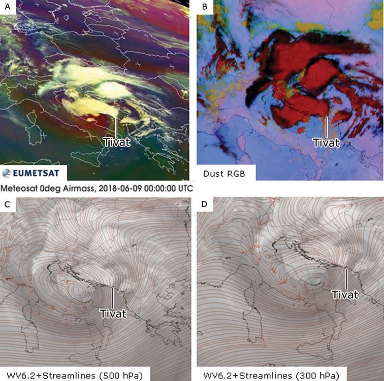
Synoptic characteristics of an extreme weather event: The tornadic waterspout in Tivat…                        71

    Montenegro doesn’t have a developed sys-                 Considering current climate change,
tem for waterspout detection or monitoring               it is quite likely that such events are going
of other air vortices. The only way to record            to occur more often so it is necessary to pay
such weather events is when a meteorological             more attention to waterspouts and to other
technician at a weather station reports that             extreme weather events.
a waterspout or a landspout has occurred,                    Therefore, the research objective of this
or when local people, tourists or print and              paper is a detailed synoptic analysis
electronic media deliver the information                 of a severe weather event, the waterspout
of such an event on the internet. As it is said,         recorded in Tivat (the coordinates: 42.40°N,
a waterspout is not something unusual for                18.73°E, elevation 5.4 m) on June 9, 2018,
the Eastern Adriatic coast, that is, for the             which swept over the town in the early
Montenegro coast, but being exclusively local            morning hours (around 03:00 CET, that is,
in nature, many waterspouts occur unnoticed.             01:00 UTC). An extreme rainfall, strong wind
Print and electronic media, as well as some              gusts and thunderstorm processes were
individuals have recorded a few waterspout               recorded locally in a short time period. This
events along the Montenegro coast (Tab. 1),              extreme weather event caused significant
but such information cannot be confirmed                 property damage, but fortunately no human
by the national Institute of Hydrometeorol-              losses. In order to emphasize the fact that
ogy and Seismology of Montenegro (IHMSM)                 extreme weather events can be potentially
since the Institute doesn’t have the events              forecasted, numerical model outputs, which
recorded in its database. Therefore, the                 were obtained one or two days before the
waterspout event on June 9, 2018 in Tivat has            waterspout event, have been analysed.
been analysed for three reasons:                         It is important to point out that the water-
1. there was an information issued by an                 spout had been forecasted two days before
   official national institution (IHMSM), that           it actually occurred. Therefore, this paper has
   is, the weather station at the Tivat airport,         another objective: to suggest the fact that
   which confirmed the waterspout event that             such events can be timely forecasted with
   caused a real chaos on its narrow path;               high probability by analysing various synop-
2. these events have been more often record-             tic tools. It is of practical significance since
   ed during the last 10 years;                          that way human lives and property could
3. a waterspout of such intensity has not been           be saved.
   recorded on the Montenegro coast so far.

Table 1. Examples of recorded waterspouts on the Montenegrin coast

                          Published
         Location                                                        Source
                           online

Budva                August, 8, 2010      https://www.youtube.com/watch?v=O38ZkIqRfBM
Ulcinj               August, 28, 2013     https://www.youtube.com/watch?v=C0cO7SW4Vc4
Budva                September, 19, 2016 https://www.cdm.me/drustvo/video-i-foto-cudo-prirode-vise-pijavica-
                                         na-crnogorskom-primorju/
Bar                  September, 9, 2017   https://www.blic.rs/vesti/svet/vreme-divlja-i-na-jadranu-mali-tornado-
                                          u-crnoj-gori-foto/xbtwp0x
Herceg Novi          February, 18, 2017   http://www.rtcg.me/vijesti/drustvo/156872/dvije-pijavice-na-ulazu-u-
                                          boku.html
Budva and Bar        January, 14, 2018    https://www.youtube.com/watch?v=F4cO_8j_bwk
Ulcinj               November, 11, 2019 https://www.antenam.net/drustvo/139281-pogledajte-pijavica-na-
                                        moru-kod-ulcinja

                                                                        Geographia Polonica 2021, 94, 1, pp. 69-90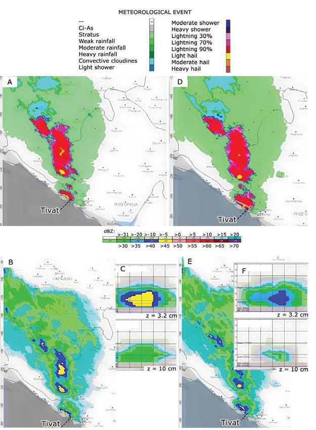
72                                                                            Jovan Mihajlović et al.

                                                    configuration of the terrain, stronger winds
Study area, data                                    in the Bay often form eddy currents.
and methodology                                         The Bay of Kotor is one of the most beau-
Study area                                          tiful bays in the Mediterranean. It looks like
The study includes the southwest part of Mon-       Scandinavian fjords, but it is tectonically
tenegro, that is, the Bay of Kotor and the town     predisposed and morphologically formed
of Tivat in which the waterspout was recorded       by exogenous forces (karst, fluvial, and
in the early morning hours on June 9, 2018.         other erosion processes). The whole of the
Montenegro has a very heterogeneous relief          southwest part of Montenegro is formed
and the configuration and orography of the          by limestone of great compactness. The Bay
Bay of Kotor are very complex. In geomor-           of Kotor stretches inland for about 28 km.
phological terms, the Bay of Kotor is a unique      The Bay of Kotor lies within the Mediterra-
entity of the Adriatic Sea. The bay is sur-         nean climate (according to Köppen climate
rounded by slopes of mountains whose peaks          classification Csa type) which is modified
rise above 1500 m (Orjen, 1894 m; Lovćen,           in the hinterland on mountain slopes as alti-
1749 m) and has a specific shape with two           tude increases. In the immediate hinterland
narrows and two extensions (Fig. 1). The shape      of the Bay of Kotor is Mount Orjen, on whose
of the bay has quite a strong impact on wind        slopes lies the site of Crkvice, known for its
speed and direction. Specifically, the southern     heavy rainfall. The average annual rainfall
winds are getting stronger in the Bay since         in Crkvice is about 4600 mm – it is probably
the currents are tight. In the southern cur-        the wettest place in Europe. Such a large
rents, the air forcibly rises along the slopes      amount of precipitation is undoubtedly due
of the mountains, that is, it is cooling, which     to the position of Crkvice in relation to the
causes the condensation of water vapor, the         dominant moist air masses from the south
formation of frequent thunderstorm clouds,          (Burić et al., 2013; 2014). This extreme rain-
and the precipitation of typical orographic         fall is related to certain types of atmospheric
type. The north and northeast wind (bora)           circulation, shown by the “SynopVisGross-
in winter cools the air in the Bay, while in sum-   wetterlagen” (SVG) series, which is a part
mer it can raise its temperature. Due to the        of the Hess and Brezowsky Grosswetterlagen
                                                    (GWL) system (Ducić et al., 2012).

                                                    Data and methodology
                                                    During the research and while analysing
                                                    meteorological conditions, which caused the
                                                    waterspout event in Tivat, the data about
                                                    the surface and upper level structure of the
                                                    atmosphere (absolute topography (AT) maps
                                                    500 hPa / wind on 300 hPa), composite syn-
                                                    optic diagrams of various instability param-
                                                    eters (ML CAPE, LI, Soaring index, SRH),
                                                    as well as diagrams of relative vorticity and
                                                    relative vorticity advection on 500 hPa were
                                                    used. Sounding measurements and wind
                                                    hodograph in the form of emagram (in reso-
                                                    lution of 0.5 km) were obtained on the basis
                                                    of operational WRF-NMM model (Janjic
Figure 1. Location of the Bay of Kotor in Monte-    et al., 2001; Janjic, 2003; Skamarock et al.,
negro (MNE) and the Western Balkans                 2008; Powers et al., 2017), which uses the

Geographia Polonica 2021, 94, 1, pp. 69-90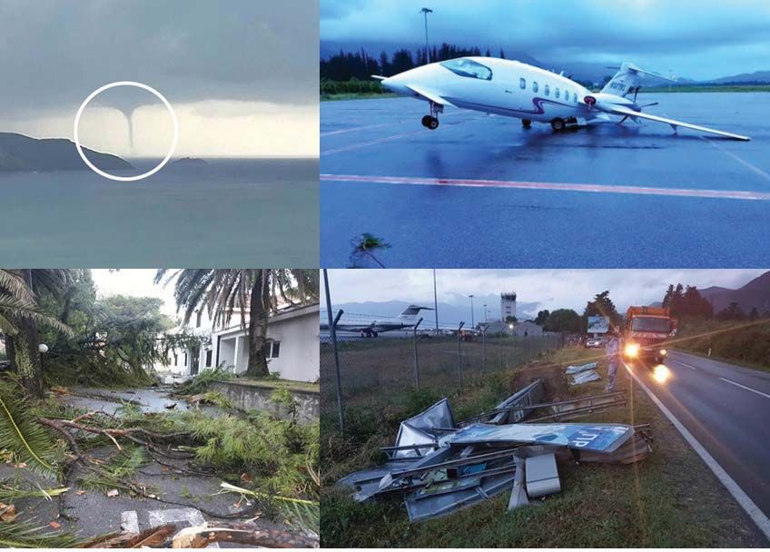
Synoptic characteristics of an extreme weather event: The tornadic waterspout in Tivat… 73
data of the global model for medium-range basis of POM (Princeton Ocean Model, that is,
weather forecast from Reading as input AREG: Adriatic Regional model) ocean model
parameters (ECMWF). Cloudiness, which which is used by the Adriatic Forecasting Sys-
caused the waterspout occurrence in Tivat, tem (AFS) (operational from April 2003), and
was observed by meteorological radar which is developed and maintained by the
MRL-5 of dual wavelength (1 = 3.2 cm, Italian Group of Operational Oceanography
2 = 10 cm), in the radar centre in Kosutnjak- (GNOO) (Oddo et al., 2005; 2006, Guarnieri
Belgrade. The most important details of this et al., 2008). The ocean model includes the
cloudiness, made in the ASU-MRL 2012 soft- whole of the Adriatic basin with a horizon-
ware for the time periods from 00:27 and tal resolution grid of 1/45° (about 2.2 km),
00:31 UTC (Fig. 8) are: composite image – on 31 -layers. The topography of the basin
maximum reflectivity map (ZMAX) (3-10 cm) bottom was made on the basis of U.S. Navy
and severe weather events map (3.2 cm). 1/60° bathymetric database DBDB1, by bilin-
Tools were used in order to determine verti- ear interpolation of depth into the grid
cal cross-section of selected convective cell model. Various products of satellite images
in any direction (XSECT). from geostationary satellite METEOSAT were
The data about sea surface temperatures also used.
(SST) and temperature anomaly of the Adriat- Since waterspouts belong to remarkable
ic Sea on June 9, 2018 were obtained on the and dangerous meteorological phenomena,
Table 2. Material used in the analysis of the waterspout event in Tivat (Montenegro)
Used parameters and
Equation Source
units of measurement
E
CAPE [Jkg -1] CAPE = ∫ LFC
(lp -) dp Moncrieff & Miller (1976);
Glickman (2000)
LI [°C] LI = Tlp - T500 Galway (1956)
KO index [°C] KO = ½(··A500 +··A700) - ½ ( ··A850 +··A1000) Kunz (2007)
Soaring index [K] SOI = T850 - T500 + D500 - D700 http://www1.wetter3.de/soaring_index.html
TT index [°C] TT = (T850 - T500) + (Td850 - T500) Miller (1967)
EHI EHI = (CAPE*SRH)/160,000 Davies (1993)
H
SREH (0-1 km; 0-3 km)
[m2 s -1]
SRH = ∫0
(v-c)·dz Davies-Jones (1984)
Davies-Jones et al. (2001)
Radar data – http://www.hidmet.gov.rs
Satellite data – http://www.eumetrain.org and https://www.eumet-
sat.int/website/home/index.html
Model POM – Oddo et al. (2005, 2006); Guarnieri et al. (2008)
http://oceanlab.cmcc.it/afs (Downloads: Decem-
ber, 2018)
Emagram and wind – http://www.meteo.co.me/
hodograph
Fujita Scale – Fujita (1981)
(https://www.spc.noaa.gov/faq/tornado/f-scale.html
SYNOP data and other – http://www.meteo.co.me/
prognostic and analyti- http://www.hidmet.gov.rs
cal material
Geographia Polonica 2021, 94, 1, pp. 69-90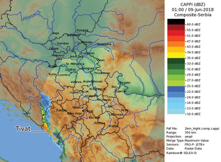
74 Jovan Mihajlović et al.
that is, atmospheric hazards, we have applied cyclones, with the trough extending along
the research methodology used in Florida the Atlantic facade of Europe, were noticed
(USA) (Rossow, 1970; Golden, 1977; Wakimo- – the so-called cut-off low closed by isotherm
to & Lew, 1993), and also in different parts of -20°C. There was an inflow of warm air
of the Mediterranean (Sioutas & Flocas, 2003; from the northwest of Africa moving over the
Sioutas & Keul, 2007; Sioutas, 2011; Matsang- southwest and south of Europe, and over the
ouras et al., 2017). We have used the method central parts up to the south of Scandinavia.
of synoptic analysis in the research: surface All of this was happening within an upper-air
temperature analysis (SST) of the Adriatic southwest flow.
Sea based on the AREG ocean model, synop- Synoptic material analysis from 00 UTC
tic types analysis, radiosounding analysis and and 06 UTC indicates that the shallow sur-
wind hodograph analysis, atmospheric stabil- face cyclone, with the centre above the
ity analysis, analysis of various thermodynam- mid-Adriatic, moved slowly over the Balkan
ic instability parameters, and wind parameter Peninsula during the night of June 8-9, 2018.
analysis, satellite and radar images analysis, In the same period, an axis of instability
and the Fujita Scale (Tab. 2). trough over the Adriatic was noticed at the
The synoptic material for this research AT 500 hPa map. The area of Montenegro
has been mainly obtained from the national was in the front part of both of these baric
Institute of Hydrometeorology and Seismol- features, that is, under the influence of the
ogy of Montenegro (IHMSM) and the Repub- moist and instable south-southwestern flow.
lic Hydrometeorological Service of Serbia In the centre of the depression the tempera-
(RHMSS). Both IHMSM and RHMSS use ture at AT 500 mb was around -15°C, at AT
the WRF-NMM regional numerical model 850 mb around 10°C, and at the surface
in weather forecasting. SYNOP data from around 25°C, which indicates a pronounced
meteorological stations in Montenegro, vertical thermal gradient.
obtained from IHMSM, have also been used. On the AT 700 hPa map (Fig. 2C),
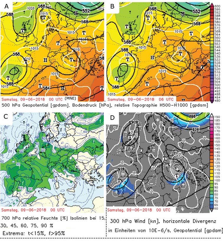
an area of extreme relative air humidity can
Results be observed in the whole of the Adriatic basin
and, particularly, in the west Balkans, that is,
Analysis of global forecast models the Bay of Kotor-around 90-95%. On the AT
Two days before the waterspout event, the 300 hPa (Fig. 2D) a streak of jet stream (so-
outputs of global forecast models indicated called jet streak) is noticed above the research
a possibility of an extreme weather event dur- area (the Bay of Kotor), with winds reaching
ing the night of 8 and 9 June, 2018. The day the speed of around 90 kn in the axis itself,
after, a new initialization of forecasting mod- that is, above the cyclonic field and frontal
els confirmed a strong atmospheric insta- zone at the surface. A horizontal field of posi-
bility and, therefore, increased probability tive divergence is pronounced, supplying itself
of a waterspout formation. with kinetic energy from the jet streak. This
The structure of the upper-level atmos- field of positive divergence at 300 hPa causes
phere is shown by absolute topography maps air convergence at the surface, which makes
(AT). On the AT 500 hPa topography maps ideal conditions for a waterspout to develop.
at 00 UTC and 06 UTC on June 9, 2018 Strong whirlwinds, such as waterspouts
(Fig. 2, A and B) a deep upper-level depres- and landspouts, are very likely to be formed
sion was observed in the northeast of Europe in specific meteorological conditions. These
along with a low surface pressure. Low val- are local events, and it should be empha-
ues of geopotential heights within the trough sized that they cannot be forecasted with
of an upper-level cyclone indicate extremely great probability based on the analysis
cold air (about -30°C). Above Scotland and of global numerical models. In order to fore-
northwest of Spain, the centres of secondary cast extreme weather events (thunderstorm
Geographia Polonica 2021, 94, 1, pp. 69-90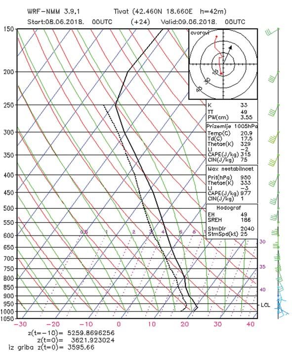
Synoptic characteristics of an extreme weather event: The tornadic waterspout in Tivat…                     75

Figure 2. Geopotential and temperature at 500 hPa at 00 UTC (A) at 06 UTC (B), relative humidity
at 700 hPa (C) and wind, horizontal divergence and geopotential at 300 hPa (D) over Europe at 00 UTC,
June 9, 2018
Source: Based on data from http://www1.wetter3.de/Archiv/

processes, storm winds, heavy rainfall, water-         Bay of Kotor (Tivat), key instability indices
spouts, etc.) atmospheric instability indices          and wind parameters forecasted by NCEP
have been used in the following analysis.              GFS model have been analysed for synoptic
                                                       period 00 UTC (Fig. 3). The waterspout was
Atmospheric instability indices                        formed between 00-01 UTC, but the GFS
                                                       model parameters are available only in main
In order to have a better insight into mes-            synoptic periods. Therefore, the 00 UTC
oscale processes which preceded and                    period will be considered as credible and the
led to the waterspout formation in the                 results as convincing. The focus of the analysis

                                                                     Geographia Polonica 2021, 94, 1, pp. 69-90
76                                                                               Jovan Mihajlović et al.

Figure 3. The forecast parameters at 00 UTC, June 9, 2018: (A) LI and ML CAPE, (B) Soaring index
and convective clouds, (C) KO index and vertical motion, (D) relative vorticity and wind at 500 hPa,
(E) advection of absolute vorticity at 500 hPa, (F) (0-1 km) SREH (shaded) and the sea level pressure
in hPA (contures), (G) (0-3 km) SREH (shaded) and the sea level pressure in hPA (contures), (H) surface
temperature of the Adriatic Sea according to AREG model and (I) the temperature anomaly according
to AREG model
Source: Based on data from http://www1.wetter3.de/Archiv/ and http://oceanlab.cmcc.it/afs/

is on the genesis, development and impact             number of lightning strikes. Estimated value
area of the waterspout.                               of LI (Lifted index) within the research area
   The value of the of ML CAPE index (Mixed           ranged from -2 to -6 and indicated marginal
Layer Convective Available Potential Energy)          and/or large instability in the troposphere
was high over the whole area of the Balkans,          (Fig. 3A). Soaring index had forecasted values
and the strongest convective instability was          of 35 К for the research area and indicates
present along the Montenegro coastline and            80% risk of a thunderstorm. Estimated con-
on the west and northwest of Serbia – around          vective cloudiness for the observed period
2000 J/kg, which means a rapid vertical               was 75% (Fig. 3B). КО index had forecasted
storm development with a strong updraft.              values from -6 to -12, that is, all values
They also indicate a possibility of a large           КО ≤ 0 indicate widespread thunderstorms

Geographia Polonica 2021, 94, 1, pp. 69-90
Synoptic characteristics of an extreme weather event: The tornadic waterspout in Tivat…                     77

and potentially instable atmosphere. Vertical          environment (instability energy in the atmos-
motion in the observed area had forecasted             phere, as well as pronounced vertical move-
values of -38 to -46 hPa·h -1, which indicated         ments, wind shear and a positive vorticity,
strong convective updrafts, particularly deep          extremely high relative air humidity-around
moist convection and cumuliform clouds with            95%, T2m = 25°C, T850hPa = 10°C, T500hPa = -15°C),
vertical development. (Fig. 3C).                       created ideal conditions for a waterspout
    As vertical motions were pronounced and            development. Warm and moist air was pre-
there were conditions for deep convection,             sent at the surface and there was cold air
vorticity concentration of the rotating updraft        in upper-level within the cut-off low. A local
along cyclonic wind shear axis enhanced the            cyclonic field was formed at the surface.
probability for the waterspout development.            Dynamic conditions at 300 mb indicate
Strong SW upper-level flow (33-47 kn) brought          a positive divergence field and a jet streak.
warm and moist air and there was an area               Therefore, thermodynamic conditions in syn-
of positive relative vorticity 10-16 (10E-5/S)         optic scales formed ideal conditions for the
(Fig. 3D). This argument was confirmed by the          waterspout event in Tivat on June 9, 2018
fact that on the isobar height of 500 hPa              (around 01 UTC).
advection of absolute vorticity was positive
and amounted to 0.03-0.05 (Fig. 3E).                   Analysis of WRF-NMM model wind
    Analysed SRH (storm relative helicity) wind        emagram and hodograph
factors had positive values for the research
area of 250-300 m -2s-2 (0-1 km) and 400-              The WRF-NMM model (Janjic, 2003), which
600 m -2s-2 (0-3 km) (Fig. 3, F and G). These          uses global model data as input param-
values indicated an increasing threat of tor-          eters from Reading medium-term fore-
nadoes and supercells. Based on CAPE and               cast (ECMWF), has been in operational
SRH parameters, EHI index was estimated                use by the IHMSM. Based on WRF-NMM
for the research area. The value of this index         model, an emagram and hodograph for
ranged from 3.1-7.5 and indicated a possi-             the Tivat airport were made with resolution
bility of tornado events of various intensity          of 0.5 km (00 UTC). The emagram shows
according to F-scale. Negative (cold) advec-           increased vertical gradients of meteorologi-
tion of air temperature (-15°C) was present            cal parameters-temperature decrease with
at the height. AREG model (Fig. 3, H and I)            height, increased relative humidity at the
shows high air temperature and high sea                surface, sudden change of wind speed with
surface temperature (SST) of the Adriatic              height and wind shear (Fig. 4).
Sea in the vicinity of the Montenegro coast                Vertical profile of the atmosphere for
(around 25°C), as well as temperature anom-            Tivat in the observed period indicates adi-
alies (>1.3°C). This high air temperature was          abatic instability from the lowest levels
pushed by cold air inflow from upper-level             (LCL = 540 m), through the whole vertical pro-
atmosphere and cold frontal zone at the sur-           file, and up to the highest layers. Surface air
face. Convergence line was formed at the               temperature was 20.9°C, while dew point tem-
surface on the sea and such mesoscale syn-             perature was over 17.5°C. The zero isotherm
optic environment favoured convective initia-          height was H0 = 3.6 km, and the height of iso-
tion and intensification, that is, a waterspout        therm H -10 = 5.3 km. CIN (convective inhibition
development.                                           or negative CAPE) in the layer of maximum
    Based on synoptic material analysis, it can        instability at 950 mb was 1 (which is a weak
be said that mesoscale and synoptic condi-             cap by definition), while CAPE in this layer was
tions on all levels of the atmosphere (sea             977 J/kg (which is a positive CAPE by defini-
level, AT 850 hPa, AT 700 hPa, AT 500 hPa,             tion), so in this case there was a penetration
AT 300 hPa) were favourable for waterspout             of capping layer and lower PBL lifting in the
formation and development. Such synoptic               region of positive CAPE, and thus favourable

                                                                     Geographia Polonica 2021, 94, 1, pp. 69-90
78 Jovan Mihajlović et al.
Figure 4. WRF-NMM model emagram and wind hodograph of 0.5 km resolution (00 UTC)
Source: Based on data from http://www.meteo.co.me/
conditions for a deep moist convection were (186 m2s-1), suggested a possibility of a severe
created. The -3 value of LI in the layer of maxi- weather event.
mum instability of 950 mb indicates marginal
instability. Convective indices, as KI (33) and Analytic material analysis
TT index (49), indicated a moderate convec- SYNOP data
tive potential and possible thunderstorms.
Hodograph (polar diagram in the In the previous part of this paper, the outputs
upper right corner of the emagram) shows of numerical models have been analysed.
an increase of wind velocity with height- They were obtained one or two days before
up to 35 knots at the 150-mb layer, as well the waterspout event, which occurred in the
as wind shear in cumulonimbus at the level early morning hours of 9 June, 2018. In order
of 800-850 mb. The storm was moving at the to confirm the forecast, the following part
speed of 25 knots, and the storm direction deals with analytical material based on SYN-
was 204°. Wind parameters indicating a rota- OP (surface synoptic observations), satellite
tion within the storm, EH (49 m2s-1) and SREH and radar data.
Geographia Polonica 2021, 94, 1, pp. 69-90Synoptic characteristics of an extreme weather event: The tornadic waterspout in Tivat… 79
On June 9, 2018 (00-06 UTC), the surface same moment of the waterspout formation.
and upper-level structure of the atmosphere Until 06 UTC, the frontal system kept on mov-
over Europe was complex. Analytical maps ing towards the east, gradually weakening and
of surface pressure, from 00 and 06 UTC the pressure began to rise on the west of it.
(Fig. 5, A and B), show that in the north-east-
ern part of Europe there was an occluded Satellite data
front within a cyclone, moving slowly towards Various products of the second genera-
the east. A shallow depression with the centre tion meteorological satellite (METEOSAT)
over the Bay of Biscay was observed on the have been used in the analysis: MSG-Air-
maps and its long occluded front was stretch- mass RGB, Dust RGB; WV6.2+Streamlines
ing over the central part of the Pyrenees, far (500 hPa/300 hPa). Satellite images (00 UTC)
to the west of the Mediterranean and north- indicate convective cloudiness over most
west of Africa. A shallow cyclone was over the part of the Adriatic Sea and the southwest-
Balkans with the centre above the Mid Adriat- ern and western part of Montenegro (the
ic, and farther northward, above the Central Bay of Kotor), which corresponds with the syn-
Europe, there was a convergence line. optic mesoscale situation of that day. The Fig-
Higher resolution maps showed the cold ure 6A in Airmass RGB colour combination
front moving over the Southeast Europe indicates a convective cloudiness above the
(Fig. 5C), and at about 03 UTC the frontal line mid- Adriatic coast and the Bay of Kotor, its
passed over the Bay of Kotor, exactly at the shifting and spreading towards the north
H H 1015
H
H 1015 1020 H
1020 T T T
1020
T T
1015 H 1015
T
1015
T 1010 H T
T H 1010
T 1010
1015 T H
H T
T T
H 1010
0
V N
1008
N1010
1006
N
1014
N
1012
0 1012 1014 1014 1012
Figure 5. Surface synoptic map: over Europe at 00 UTC (A) and 06 UTC (B) and over the Balkan Peninsula
at 03 UTC (C) on June 9, 2018
Source: Based on data from http://www1.wetter3.de/Archiv/
Geographia Polonica 2021, 94, 1, pp. 69-9080 Jovan Mihajlović et al. Figure 6. (A) Airmass RGB with corresponding cloudiness and atmospheric physics, (B) dust RGB, (C) WV6.2+Streamlines (500 hPa) and (D) WV6.2+Streamlines (300 hPa), at 00 UTC, June 9, 2018 Source: Based on data from http://www.meteo.co.me/ and http://eumetrain.org under the influence of S-SW upper-air flow. Dust RGB (Fig. 6B) points to high opaque Red shades on the image point to the pres- clouds by its red shades (Cu con, TCu, Cb) ence of dry and warm air mass and descend- above the observed area. Dark blue and ant air movement. This process is connected black colours on the image indicate the with cyclogenesis. High advection of poten- presence of high and thin cirrus clouds. tial vorticity is present (jet streak) and it indi- WV6.2+Streamlines (500 hPa and 300 hPa) cates an abrupt cyclogenesis. Green shades (Fig. 6, C and D) indicate an upper-air on the image indicate highly moist air mass SW flow and the cyclogenesis process in the upper troposphere and behind the in the Adriatic. convective cloudiness. White colour on the convective cell above the Bay of Kotor indi- Radar data cates high opaque clouds (a convective cell The violent process in the Bay of Kotor was is recognized by the shape, not by the colour). recorded by the Gematronik type radar Geographia Polonica 2021, 94, 1, pp. 69-90
Synoptic characteristics of an extreme weather event: The tornadic waterspout in Tivat…                     81

Figure 7. Composite radar image CAPPI (dBZ) (10 cm) at 01 UTC, June 9, 2018
Source: Based on data from http://www.hidmet.gov.rs

in the Jastrebac radar centre-Serbia (Fig. 7).         Horizontal and vertical cross-sections of the
The composite radar image clearly shows                cloudiness (XSECT) have been done for the
strong instability energy in that period (01           observed periods on the maximum reflectiv-
UTC). On the composite radar image CAPPI               ity map ZMAX (3-10 cm), as well as on the
(dBZ) (10 cm), severe weather cloudiness               map of severe meteorological events caused
was noticed moving over the Bay of Kotor,              by this cloudiness (3.2 cm).
with the maximum reflectivity on the radar                 On the map of severe meteorological
(50-55 dBZ). It has been estimated that the            events (3.2 cm) at 00:27 UTC (Fig. 8A), small
waterspout line was about 5-6 km long and              hail stones, 90% thunderstorm processes
it lasted 15-20 minutes. There were occa-              and heavy/moderate showers have been reg-
sional rain, local short showers and a thun-           istered. Maximum reflectivity map (ZMAX)
derstorm process till the middle of the day,           (3-10 cm) at 00:27 UTC (Fig. 8B) shows
but the process was most violent till 08 UTC.          severe weather cloudiness in the area of the
    Severe thunderstorm cloudiness, which              Bay of Kotor and Dubrovnik with maximum
spread over the Bay of Kotor, was moving               reflectivity of over 45 dBZ (which is, according
northeast under the influence of S-SW upper-           to the radar criteria, a condition for the hail
air flow and between 00:27 UTC and 00:31               formation). A vertical cross-section of the con-
UTC (Fig. 8) passed over Tivat with maximum            vective cell (XSECT) has been done on the map
intensity on the radar. This corresponds               for the same period under the azimuth of 124°
to already presented synoptic situation and            in the 3.2 and 10 cm resolution (Fig. 8C). Ver-
to main characteristics of isobaric relief at the      tical cross-section reveal Cb cloud dimen-
surface and in the upper-level of atmosphere.          sions-cloud zone width of over 20 km, while

                                                                     Geographia Polonica 2021, 94, 1, pp. 69-90
82 Jovan Mihajlović et al. Figure 8. Map of severe meteorological events (3.2 cm) (A and B) and maximum reflectivity map (ZMAX) (3-10 cm) (C and D) at 00:27 UTC (left) and 00:31 UTC (right). Inserted images (E and F): vertical cross- sections of the selected cell XSECT) in the resolution of 3.2 cm (upper part) and 10 cm (lower part) under the azimuth of 1240 at 00:27 UTC (E) and 1180 at 00:31 UTC (F) Source: Based on data from http://www.hidmet.gov.rs Geographia Polonica 2021, 94, 1, pp. 69-90
Synoptic characteristics of an extreme weather event: The tornadic waterspout in Tivat… 83
the height is around 16 km (the height of the precipitation (Buric et al., 2011; Buric et al.,
tropopause was 11.8 km, so the cloud lifted and 2018; Buric et al., 2019; Burić & Doderović,
penetrated the tropopause). Maximum reflec- 2020; Doderović et al., 2020). This research
tivity of the convective cell was over 45 dBZ. paper had the aim of showing synoptic con-
In the updraft zone a weakly marked WER was ditions which led to the waterspout develop-
developed (surrounded with a stronger echo ment on the coast of Montenegro in the area
from above and aside), thus the rotation was of the Tivat airport on June 9, 2018, around
not present. Weakly marked WER on the verti- 01 UTC. A detailed analysis of synoptic mate-
cal cross-section indicates that there was not rial, which was initialized one or two days
a supercell process whatsoever. before the event itself, has been done. That
Moving farther in the NE direction and way, it has been shown that, thanks to numer-
under the influence of a prevailing S-SW upper- ical models which are getting more and more
air flow, at 00:31 UTC, this convective cloudi- reliable, these and similar weather events
ness weakened, decreased in length and width could be forecasted in most cases.
as well as maximum reflectivity on the radar According to the SYNOP data obtained
image, which indicated a gradual weakening from meteorological stations of IHMSM, from
of the convective process within it (Fig. 8, D 00 UTC to 12 UTC, the total amount of pre-
and E). The weakening of the process at 00:31 cipitation was 70 mm on Cetinje, 50 mm on
UTC can be noticed on Figure 8F. the airports in Tivat and Golubovci, 34 mm in
Herceg Novi, 27 mm in Podgorica, 23 mm in
Niksic, while other stations recorded less than
Discussion
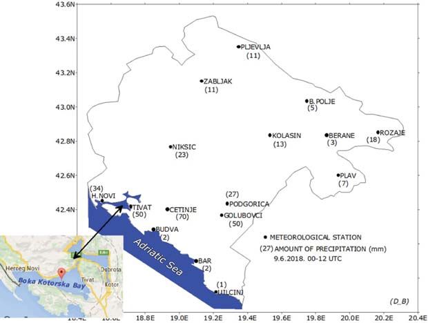
20 mm of rainfall (Fig. 9). From 01-03 UTC,
During the last two decades extreme weath- cyclonic wind gusts of 28 m·s-1 or 101 km·h -1
er events in Montenegro have been more were recorded in Herceg Novi. Anemom-
frequently detected, such as extreme tem- eter located on the weather station in Tivat
peratures, heat waves, droughts and extreme registered violent wind gusts of 18 m·s-1,
Figure 9. Amount of precipitation on weather stations in Montenegro on June 9, 2018 and the waterspout
location in the Bay of Kotor
Geographia Polonica 2021, 94, 1, pp. 69-9084 Jovan Mihajlović et al.
but since it was a typical local event, it is humid and with enough latent energy. Such
almost certain that there were even more conditions favour the development of thun-
powerful wind gusts. The sea temperature derstorm clouds- cumulonimbus (Cb), but
along the Montenegro coastline was 25-26°C. a so-called wind shear within the Cb is also
Waterspout developing process is very necessary for a waterspout development.
complex. Mesoscale synoptic and thermody- Synoptic analysis (synoptic type has been
namic conditions which favour the formation identified), instability parameter analysis,
process of a waterspout include the presence radiosounding, satellite and radar analysis,
of a gust front, convergence line and wind as well as analysis of atmospheric insta-
shear axis. High relative humidity of the air, bility have been carried out. The results
high temperature of the sea surface and weak of these analyses pointed out to thermal
tropospheric winds are also needed so that instability over a wide area of the Adriatic
a waterspout could develop (Hess & Spillane, and the Bay of Kotor in the early morning
1990; Golden & Sabones, 1991; Simpson hours on June 9, 2018, but also to favour-
et al., 1991; Choy & Sprat, 1994; Mihajlović able dynamic conditions at the surface and
et al., 2016). As an example, we can mention in the upper atmosphere.
a waterspout outbreak over the Great Lakes Severe weather, followed by a forma-
in the USA, in 2003. When the cold arctic air, tion of a vast cumulonimbus (Cb) cloud
coming from the north of the American conti- of high intensity, moved over Tivat and the
nent, flows over the warm waters of the Great Bay of Kotor with a maximum intensity on the
Lakes, ideal mesoscale synoptic and thermo- radar in the period from 01:00 to 03:00 UTC,
dynamic conditions are formed for a water- within the S-SW upper-air flow. A waterspout
spout development (Szilagyi, 2004; Mihajlović developed above the sea and soon swept
et al., 2016). over the land forming a relatively narrow
However, we should emphasize some facts and short path of 5-6 km in length. It lasted
which favour a waterspout development around 15-20 minutes in the coastal part and
while talking about the Montenegro coast, caused a real chaos. By applying the Fujita
and particularly the Bay of Kotor. The Mon- scale method and considering radar criteria,
tenegro coastline is a narrow region, with wind speed data obtained from meteorologi-
the width ranging from a few tens of meters cal stations and damage estimates, it can
to maximum 10 km. Mountains rise up to be concluded that the waterspout which
1900 m in the nearby hinterland. The Adriatic swept over Tivat on June 9, 2018 belongs
sea belongs to a group of warm seas, with the to the F0-F1 category on F-scale.
water temperature ranging from 24 to 28°C Based on methodology of synoptic type
in the summer and at the beginning of the classification (Sioutas & Keul, 2007; Sioutas,
autumn. Optimal thermodynamic condi- 2011) and thanks to a detailed analysis of the
tions for a waterspout development are high 500 mb circulation, the position and char-
surface air temperatures and the presence acteristics of isobaric shapes in the upper
of an air front passing over the warm Medi- levels, which are in relation to those at the
terranean and Adriatic waters and moving surface, synoptic type for this situation can
on towards the coastal Montenegro moun- be determined as CLOSED (closed low) – SW
tains. In both cases, there is a warm air uplift (south-west flow). Over the Adriatic Sea, Italy,
which causes the air to cool rapidly. When Croatia, Slovenia, Montenegro and Serbia
the air mass comes from the south into the there was an area of closed isobars which
Bay of Kotor, which is surrounded by moun- formed the so-called cut-off low at the height
tain slopes, air currents are compacted and of 500 mb. Isolated low pressure centres and
therefore the process of forced air updrafts cyclonic vorticity fields were present at the sur-
is more turbulent. The air in the upper lay- face. SW flow was formed and a frontal zone
ers of troposphere should be very instable, was noticed within these baric formations.
Geographia Polonica 2021, 94, 1, pp. 69-90Synoptic characteristics of an extreme weather event: The tornadic waterspout in Tivat… 85
According to the information obtained makes it difficult to record them. Montenegro
from the airport weather station in Tivat, late does not have a developed system for water-
in the night – at 01 UTC on June 9, 2018, two spouts observation and the national IHMSM
aircrafts were taken by the vortex. Those were does not have available data about water-
small business planes and one of them was spout and landspout frequency or intensity.
rotated by 180 degrees, suffering minor dam- There is a significant trend in temperature
age. It was worse with the other plane since increase during the last 6-7 decades in Mon-
the waterspout literally lifted it up, turned tenegro (Burić et al., 2019; Burić et al., 2020).
and threw it to the aircraft parking platform Generally, higher temperature means energy
(Fig. 10). The fact that the planes weighed surplus in the atmosphere which is released
more than 6 t each speaks enough about the in the form of frequent extreme weather
wind power. Nearby aircrafts, including much events. Based on available information, it is
lighter helicopters which were out of range quite likely that the waterspout frequency has
of the waterspout path, were not even moved increased at the Adriatic Sea and along the
by the storm. Along its narrow path, the Montenegro coast during the last 10 years.
waterspout damaged roofs of the houses, According to the detailed analysis of the
ripped up the trees, overturned big advertis- waterspout which occurred in Tivat (Monte-
ing billboards along the Adriatic Highway, but negrin coast) on June 9, 2018, sweeping over
fortunately, without human losses. the town in the early morning hours (at about
03:00 CET, that is, 01:00 UTC), the main
objective of this paper was to focus on these
Conclusion
potentially dangerous weather events in the
Waterspouts and similar air vortices are exclu- region of Montenegro and on necessity
sively of a local character. They mainly devel- of tracking them so that they could be fore-
op over the area having radius of 10 meters casted timely. In the context of global climate
and they last only a few minutes, which change, an early warning weather alert for
Figure 10. The waterspout in the Bay of Kotor (Tivat) and consequences of the storm in Tivat, June 9, 2018
Source: Retrieved from https://www.vijesti.me
Geographia Polonica 2021, 94, 1, pp. 69-9086 Jovan Mihajlović et al.
extreme weather events, such as a water- • sea surface temperature (SST) analysis
spout, has a great practical significance of researched area (sea or ocean);
in saving human lives and in reducing • synoptic types – application of the meth-
negative consequences. odology suggested by Sioutas and Flocas
In this particular case (waterspout (2003) and Sioutas (2011);
in Tivat), the general mesoscale synoptic situ- • radiosounding and wind hodograph
ation was characterized by thermodynamic analysis;
instability in lower and middle layers of the • thermodynamic instability parameters
atmosphere: cold front passage over the and wind parameters analysis;
warm water of the Adriatic as the main syn- • satellite and radar images analysis;
optic characteristic, pronounced directional • application of Fujita scale (F-scale).
and speed wind shear, as well as the pres- Apart from having educational and infor-
ence of jet streak and pronounced horizontal mational significance, this paper can help not
field of positive divergence over the observed only weather forecast experts, but also other
area. So, there was an advection of potential people interested in the environment. Fur-
vorticity (PV) and PV conservation into lower ther investigation into meteorological envi-
layers of the troposphere, that is, a fast cyclo- ronment, which favours waterspout forma-
genesis and atmospheric instability. tion at the Adriatic Sea and Mediterranean,
This paper presents a contribution to the is necessary in order to establish a more pre-
understanding of atmospheric conditions cise connection between presented thermo-
which create favourable synoptic and ther- dynamic parameters and mesoscale synoptic
modynamic environment for a waterspout situation. Since such events belong to atmos-
formation and development. The water- pheric hazards and present a danger to air
spout formation mechanism itself has been and water traffic, as well as to human lives,
unknown until this very day, although there a particular attention should be paid to this
are some theoretical researches (e.g. Golden, topic, not only in the region of the Mediter-
1971; Brady & Szoke, 1988; Simpson et al., ranean, but all over the world where such
1991; Choy & Sprat, 1994; Wakimoto & Lew, hazards occur.
1993; Renko et al., 2016). Based on a detailed
research done in this paper, the authors sug- Acknowledgements:
gest an application of the following synop- The authors thank IHMSM and RHMSS for
tic tools while analysing waterspout events the necessary data for this study (surface syn-
which belong to extraordinary and danger- optic maps and radar images).
ous weather phenomena, that is, to weather
hazards: Editors‘ note:
• initial analysis – various isobaric surfaces Unless otherwise stated, the sources of tables and
and other products of global and regional figures are the authors‘, on the basis of their own
models have been analysed; research.
References
Bissolli, P., Grieser, J., Dotzek, N., Welsch, M. (2007). Tornadoes in Germany 1950-2003 and their relation
to particular weather conditions. Global and Planetary Change, 57(1-2), 124-138.
https://doi.org/10.1016/j.gloplacha.2006.11.007
Brady, R.H., Szoke, E.J. (1988). The landspout – A common type of Northeast Colorado tornado. In Pre-
prints, 15th Conf. On Severe Local Storms (pp. 312-315). Baltimore, MD: American Meteorological
Society.
Geographia Polonica 2021, 94, 1, pp. 69-90Synoptic characteristics of an extreme weather event: The tornadic waterspout in Tivat… 87
Browning, K.A. (1964). Airflow and precipitation trajectories within severe local storms which travel
to the right of the winds. Journal of the Atmospheric Sciences, 21(6), 634-639.
https://doi.org/10.1175/1520-0469(1964)0212.0.CO;2
Burić, D., Ducić, V., Luković, J. (2011). Kolebanje klime u Crnoj Gori u drugoj polovini XX i početkom
XXI vijeka. Crnogorska Akademija Nauka i Umjetnosti.
Burić, D., Ducić, V., Mihajlović, J. (2013). The climate of Montenegro: Modificators and types – part two.
Bulletin of the Serbian Geographical Society, 93(4), 83-102. https://doi.org/10.2298/GSGD1304083B
Burić, D., Ducić, V., Mihajlović, J. (2014). The climate of Montenegro: Modificators and types – part two.
Bulletin of the Serbian Geographical Society, 94(1), 73-90. https://doi.org/10.2298/GSGD1401073B
Burić, D.B., Dragojlović, J.M., Milenković, M.Đ., Popović, Lj.Z., Doderović, M.M. (2018). Influence of vari-
ability of the East Atlantic Oscillation on the air temperature in Montenegro. Thermal Science,
22(1 Part B), 759-766. https://doi.org/10.2298/TSCI170710211B
Burić, D., Dragojlović, J., Penjišević-Sočanac, I., Luković, J., Doderović, M. (2019). Relationship between
atmospheric circulation and temperature extremes in Montenegro in the period 1951-2010. In W. Leal
Filho W, Trbic G, Filipovic, D. (Eds.), Climate change adaptation in Eastern Europe: Climate change
management (pp. 29-42). Cham: Springer. https://doi.org/10.1007/978-3-030-03383-5_3
Burić, D., Doderović, M. (2020). Changes in temperature and precipitation in the instrumental period
(1951-2018) and projections up to 2100 in Podgorica (Montenegro). International Journal of Climatol-
ogy, 1-17. https://doi.org/10.1002/joc.6671
Doderović, M., Burić, D., Dragojlović, J. (2020). Significance of early announcement of weather extremes:
Case study – Montenegro. EasyChair Preprint no. 3182. https://easychair.org/publications/preprint/Z42V
Choy, B.K., Spratt, S.M. (1994). A WSR-88D approach to waterspout forecasting. NOAA Tech Memo
NWS SR, 156.
Davies, J.M. (1993). Hourly helicity, instability, and EHI in forecasting supercell tornadoes. In Preprints,
17th Conf on Severe Local Storms, St Louis, MO (pp. 107-111). American Meteorological Society.
Davies-Jones, R.P. (1984). Streamwise vorticity: The origin of updraft rotation in supercell storms. Journal
of the Atmospheric Sciences, 41(20), 2991-3006.
https://doi.org/10.1175/1520-0469(1984)0412.0.CO;2
Davies-Jones, R., Trapp, R.J., Bluestein, H.B. (2001). Tornadoes and tornadic storms. In Severe Convective
Storms (pp. 167-222). Boston, MA: American Meteorological Society.
https://doi.org/10.1175/0065-9401-28.50.167
Dotzek, N. (2001). Tornadoes in Germany. Atmospheric Research, 56(1-4), 233-251.
https://doi.org/10.1016/S0169-8095(00)00075-2
Dotzek, N. (2003). An updated estimate of tornado occurrence in Europe. Atmospheric Research, 67-68,
153-161. https://doi.org/10.1016/S0169-8095(03)00049-8
Ducić, V., Luković, J., Burić, D., Stanojević, G., Mustafić, S. (2012). Precipitation extremes in the wettest
Mediterranean region (Krivošije) and associated atmospheric circulation types. Natural Hazards and
Earth System Sciences, 12(3), 687-697. https://doi.org/10.5194/nhess-12-687-2012
Fujita, T.T. (1981). Tornadoes and downbursts in the context of generalized planetary scales. Journal of the
Atmospheric Sciences, 38(8), 1511-1534.
https://doi.org/10.1175/1520-0469(1981)0382.0.CO;2
Galway, JG. (1956). The lifted index as a predictor of latent instability. Bulletin of the American Meteoro-
logical Society, 37(10), 528-529. https://doi.org/10.1175/1520-0477-37.10.528
Gianfreda, F., Miglietta, M.M., Sansò, P. (2005). Tornadoes in Southern Apulia (Italy). Natural Hazards, 34,
71-89. https://doi.org/10.1007/s11069-004-1966-3
Glickman, T.S. (2000). Glossary of Meteorology. 2nd Edition. Boston, MA: American Meteorological
Society.
Geographia Polonica 2021, 94, 1, pp. 69-9088 Jovan Mihajlović et al. Golden, J.H. (1971). Waterspouts and tornadoes over south Florida. Monthly Weather Review, 99(2), 146-154. https://doi.org/10.1175/1520-0493(1971)0992.3.CO;2 Golden, J.H. (1974). The life cycle of Florida Keys’ waterspouts. I. Journal of Applied Meteorology and Climatology, 13(6), 676-692. https://doi.org/10.1175/1520-0450(1974)0132.0.CO;2 Golden, J.H. (1977). An assessment of waterspout frequencies along the U.S. east and Gulf coasts. Jour- nal of Applied Meteorology and Climatology, 16(3), 231-236. https://doi.org/10.1175/1520-0450(1977)016%3C0231:AAOWFA%3E2.0.CO;2 Golden, J.H., Sabones, M.E. (1991). Tornadic waterspout formation near interesting boundaries. In Pre- prints, 25th International Conference on Radar Meteorology. Preprints, 25th International Conference on Radar Meteorology (pp. 420-423). Paris: American Meteorological Society. Guarnieri, A., Oddo, P., Pastore, M., Pinardi, N., Ravaioli, M. (2008). The Adriatic basin forecasting system: New model and system development. In H. Dahlin, M.J. Bell, N.C. Flemming, S.E. Petersson (Eds.), Coastal to global operational oceanography: Achievements and challenges (pp. 184- 190). Proceeding of the Fifth International Conference on EuroGOOS, 20-22 May 2008. Exeter, UK: EuroGOOS Publication. http://hdl.handle.net/2122/4782 Hagemeyer, B.H. (1994). First look at a marine supercell over the Gulf Stream. NOAA Tech Attach, SR/ SSD, 94-23, Ft Worth, TX. Hess, G.D., Spillane, K.T. (1990). Waterspouts in the Gulf of Carpentaria. Australian Meteorological Magazine, 38, 173-179. http://www.bom.gov.au/jshess/docs/1990/hess1.pdf Holzer, A.M. (2001). Tornado climatology of Austria. Atmospheric Research, 56(1-4), 203-211. https://doi.org/10.1016/S0169-8095(00)00073-9 Huschke, R.E. (Eds). (1959). Glossary of Meteorology. Boston, Mass: American Meteorological Society. IPCC. 2014. Climate Change 2014: Synthesis Report. Contribution of Working Groups I, II and III to the Fifth Assessment Report of the Intergovernmental Panel on Climate Change [Core Writing Team, R.K. Pachauri and L.A. Meyer (eds.)]. Geneva, Switzerland: IPCC. Janjic, Z.I., Gerrity Jr, J.P., Nickovic, S. (2001). An alternative approach to nonhydrostatic modeling. Monthly Weather Review, 129(5), 1164-1178. https://doi.org/10.1175/1520-0493(2001)1292.0.CO;2 Janjic, Z.I. (2003). A nonhydrostatic model based on a new approach. Meteorology and Atmospheric Physics, 82, 271-285. https://doi.org/10.1007/s00703-001-0587-6 Kunz, M. (2007). The skill of convective parameters and indices to predict isolated and severe thunder- storms. Natural Hazards and Earth System Sciences, 7(2), 327-342. https://doi.org/10.5194/nhess-7-327-2007 Kurnik, B., Füssel, H.M., van der Linden, P., Simmons, A. (2017). Changes in the climate system, Section 3.2: Atmosphere. In Climate change, impacts and vulnerability in Europe 2016: An indicator-based report (pp 69-88). EEA report, No 1/2017. https://www.eea.europa.eu/publications/climate-change- impacts-and-vulnerability-2016 Matsangouras, I., Nastos, P., Bluestein, H., Pytharoulis, I., Papachristopoulou, K., Miglietta, M. (2017). Analysis of waterspout environmental conditions and of parent-storm behaviour based on satellite data over the southern aegean sea of greece. International Journal of Climatology, 37(2), 1022-1039. https://doi.org/10.1002/joc.4757 Mihajlović, J., Ducić, V., Burić, D. (2016). Tornadic waterspout event in Split (Croatia) – analysis of mete- orological environment. Journal of the Geographical Institute Jovan Cvijić, SASA, 66(2), 185-202. https://doi.org/10.2298/IJGI1602185M Miller, R.C. (1967). Notes on analysis and severe storm forecasting procedures of the Air Force Global Weather Central. Technical Report 200 (Rev). Air Weather Service, Scott Air Force Base. Moncrieff, M.W., Miller, M.J. (1976). The dynamics and simulation of tropical cumulonimbus and squall lines. Quarterly Journal of the Royal Meteorological Society, 102(432), 373-394. https://doi.org/10.1002/qj.49710243208 Geographia Polonica 2021, 94, 1, pp. 69-90
Synoptic characteristics of an extreme weather event: The tornadic waterspout in Tivat…                           89

Mostafa, A.N., Wheida, A., El Nazer, M., Adel, M., El Leithy, L., Siour, G., … Alfaro, S.C. (2019). Past
   (1950-2017) and future (-2100) temperature and precipitation trends in Egypt. Weather and Climate
   Extremes, 26, 100225. https://doi.org/10.1016/j.wace.2019.100225
Oddo, P., Pinardi, H., Zavatarelli, M. (2005). A numerical study of the interannual variability of the Adri-
   atic Sea (2000-2002). Science of The Total Environment, 353(1-3), 39-56.
   https://doi.org/10.1016/j.scitotenv.2005.09.061
Oddo, P., Pinardi, H., Zavatarelli, M., Colucelli, A. (2006). The Adriatic basin forecasting system. Acta
   Adriatica: International Journal of Marine Sciences, 47(Suppl), 169-184. https://hrcak.srce.hr/8550
Palmieri, S., Pulcini, A. (1979). Trombe d‘aria sull‘Italia. Rivista di Meteorologia Aeronautica, 39(3-4), 263-277.
Penzar, B., Penzar, I., Orlić, M. (2001). Vrijeme i klima hrvatskog Jadrana. Zagreb-Koprivnica-Split:
   Dr. Feletar, Hrvatski hidrografski institut.
Peterson, R.E. (1998). A historical review of tornadoes in Italy. Journal of Wind Engineering and Industrial
   Aerodynamics, 74-76, 123-130. https://doi.org/10.1016/S0167-6105(98)00010-5
Pipinato, A. (2018). Recent northeast Italian tornado events: lesson learned for improving structures.
   Natural Hazards, pp 40. https://doi.org/10.1007/s11069-018-3380-2
Powers, J.G., Klemp, J.B., Skamarock, W.C., Davis, C.A., Dudhia, J., Gill, D.O., … Duda, M.G. (2017).
   The weather research and forecasting model: Overview, system efforts, and future directions. Bulletin
   of the American Meteorological Society, 98(8), 1717-1737. https://doi.org/10.1175/BAMS-D-15-00308.1
Radović, V., Iglesias, I. (2020). Extreme weather events: Definition, classification, and guidelines towards
   vulnerability reduction and adaptation management. In W. Leal Filho, A.M. Azul, L. Brandli, P.G. Özu-
   yar, T. Wall (Eds.), Climate Action. Cham: Springer. https://doi.org/10.1007/978-3-319-95885-9_68
Renko, T., Kuzmić, J., Šoljan, V., Strelec Mahović, N. (2016). Waterspouts in the Eastern Adriatic from
   2001 to 2013. Natural Hazards, 82, 441-470. https://doi.org/10.1007/s11069-016-2192-5
Rossow, V.J. (1970). Observations of waterspouts and their parent clouds. Washington: National Aero-
   nautics and Space Administration.
   https://ntrs.nasa.gov/archive/nasa/casi.ntrs.nasa.gov/19700020540.pdf
Snow, J. (2020). Tornado. In Encyclopædia Britannica. Retrieved from
    https://www.britannica.com/science/tornado
Simpson, J., Roff, G., Morton, B.R., Labas, K., McCumber, M., Penc, R. (1991). A Great Salt Lake water-
   spout. Monthly Weather Review, 119(12), 2741-2770. https://doi.org/10.1175/1520-0493-119-12-2740.1
Sioutas, M.V. (2011). A tornado and waterspout climatology for Greece. Atmospheric Research, 100(4),
   344-356. https://doi.org/10.1016/j.atmosres.2010.08.011
Sioutas, M.V., Keul, A.G. (2007). Waterspouts of the Adriatic, Ionian and Aegean Sea and their meteoro-
   logical environment. Atmospheric Research, 83(2-4), 542-557.
   https://doi.org/10.1016/j.atmosres.2005.08.009
Skamarock, W.C., Klemp, J.B., Dudhia, J., Gill, D.O., Barker, D., Duda, M.G., … Powers, J.G. (2008).
   A description of the advanced research WRF Version 3. (No. NCAR/Tech. Note – 475+STR). University
   Corporation for Atmospheric Research. http://dx.doi.org/10.5065/D68S4MVH
Sioutas, M., Flocas, H.A. (2003). Hailstorms in Northern Greece: synoptic patterns and thermodynamic
   environment. Theoretical and Applied Climatology, 75, 189-202.
   https://doi.org/10.1007/s00704-003-0734-8
Spinoni, J., Szalai, S., Szentimrey, T., Lakatos, M., Bihari, Z., Nagy, A., … Vogt, J. (2014). Climate of the
   Carpathian Region in the period 1961-2010: Climatologies and trends of 10 variables. International
   Journal of Climatology, 35, 1322-1341. https://doi.org/10.1002/joc.4059
Stadtherr, L., Coumou, D., Petoukhov, V., Petri, S., Rahmstorf, S. (2016). Record Balkan floods of 2014
   linked to planetary wave resonance. Science Advences. 2(4), e1501428.
   https://doi.org/10.1126/sciadv.1501428

                                                                           Geographia Polonica 2021, 94, 1, pp. 69-90
You can also read