HISTORY OF WEATHER OBSERVATIONS - Sonoma, California 1850 1911
←
→
Page content transcription
If your browser does not render page correctly, please read the page content below
HISTORY OF WEATHER OBSERVATIONS
         Sonoma, California
            1850 – 1911

                            June 2006

                          Prepared By
                          Glen Conner
                       9216 Holland Road
                      Scottsville, Kentucky

 This report was prepared for the Midwestern Regional Climate Center
  under the auspices of the Climate Database Modernization Program,
   NOAA's National Climatic Data Center, Asheville, North Carolina.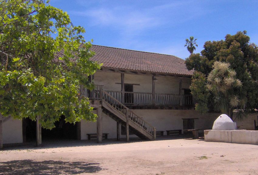
ACKNOWLEDGEMENTS

     Several people contributed to the research for this study. Among them was Diane Smith of
the Depot Park Museum of the Sonoma Valley Historical Society who readily gave of her
knowledge of Sonoma history. She was most helpful in providing photographic records.

      Most of all there must be acknowledgement of the efforts of the observers who produced
the climate record that we now treasure as a key to understanding the climate. Those who
preserved those records were important as well.

     To you who are reading this, thanks for your interest in preserving the history of weather
observations.

                                                ii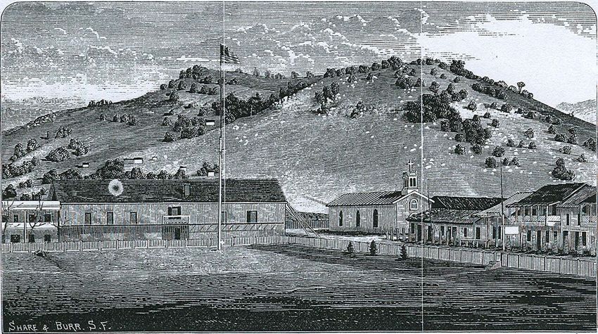
CONTENTS

Acknowledgements                                  ii
List of Illustrations                             iv

Introduction                                      1
The Location                                      3
Record                                            4
Goal of the Study                                 5

Location of Observations                          6
Surgeon General Years 1850-1851                   6
Signal Service Years 1882-1892                    9
Weather Bureau Years 1892—1911                   12

Instrumentation                                  15
Thermometer                                      15
Hygrometer                                       15
Rain Gauge                                       16
Barometer                                        18
Shelter                                          19
Wind Instruments                                 21

The Observers                                    22
The Surgeon General Years 1850—1851              22
The Signal Service Years 1875—1892               22
The Weather Bureau Years 1908—1948               23

The Observations                                 24
Observations 1850—1851                           24
Observations 1862—1863                           24
Observations 1882—1892                           24
Observations 1892—1911                           27

Digital Record                                   27

Climatology                                      28

Appendix 1     Methodology                       32

Bibliography                                     33

                                       iii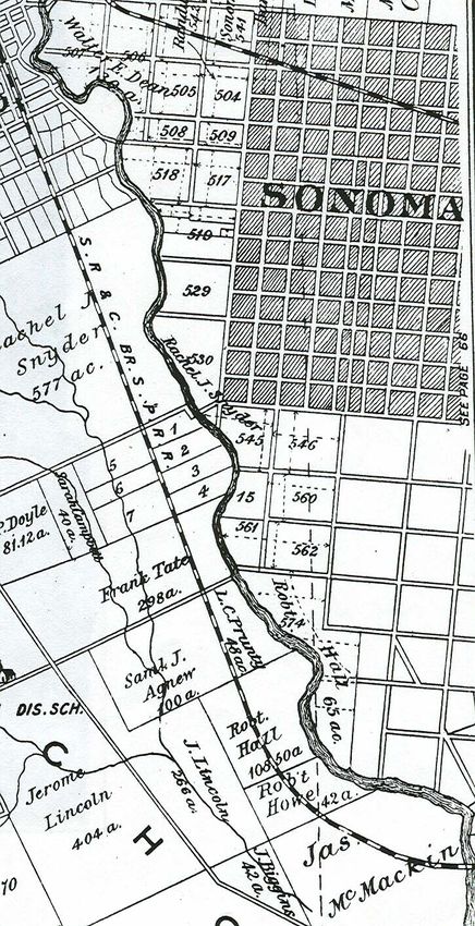
ILLUSTRATIONS

Figures

1.    First Weather Observations from Sonoma         2
2.    Looking North Along Sonoma Creek               4
3.    Sonoma Barracks 2006                           6
4.    Sonoma Barracks 1873                           6
5.    Courtyard at Sonoma Barracks                   8
6.    Substation History Form 530                    9
7.    Map and Orthophoto of Observation Locations   10
8.    Robert Hall Residence                         11
9.    Robert Hall Barn and Orchard                  12
10.   Inspection Report 1906                        13
11    Green Maximum and Minimum Thermometers        15
12.   DeWitt Conical Rain Gauge                     16
13.   Conical Rain Gauge                            17
14.   Standard Rain Gauge                           18
15.   Mercury Barometer                             19
16.   Cotton Region Shelter                         20
17.   Weather Vane                                  21
18.   Robert Hall Remarks 1885                      25
19.   Instructions for Casual Phenomena             26
20.   Hall’s Comments March 1886                    26
21.   Hardy’s Comments 1873                         28
22.   Hardy’s First Newspaper Report                29

Tables
1.   Annual Precipitation Sonoma County 1853-1886   30

                                            iv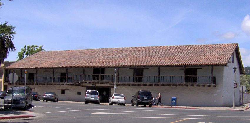
HISTORY OF WEATHER OBSERVATIONS
                                 Sonoma, California
                                    1851 —1911

                                        Glen Conner
                            Kentucky State Climatologist Emeritus

INTRODUCTION

      When Dr John Campbell arrived in Sonoma, the town had already experienced several
historic events. Its Mission San Francisco Solano de Sonoma was established in 1823. General
Vallejo, the military commander of the northern area of Mexico, founded Sonoma in 1835 as a
buffer against the Russian colony at Fort Ross, located a few miles away. In 1846, the flag of the
California Republic was first raised over Sonoma as a result of the Bear Flag Revolution.

     In July 1846, the first United States Flag was raised at Sonoma by an officer who came
ashore from a U.S. Frigate, the Portsmouth, that was anchored in the harbor.

               I have the pleasure to announce, that the Flag of the United States,
               was, on the 7th inst hoisted at Monterey, and will I expect this day,
               be substituted for the revolutionary flag recently hoisted at
               Sonoma.

     The U.S. Army subsequently occupied the town. The Post’s Return dated April 1847
reported the arrival of the 7th Regiment of the New York Volunteers commanded by Capt J. E.
Brackett.

              The company (C) arrived at Sonoma April 4 1847 from San
              Francisco and took post at the public Barracks as the Garrison of
              the place.

The Return reported that the organization included two officers and 59 enlisted men.

      The Post’s Return1 for Sonoma for September 1849 was the first to mention the presence of
a surgeon. That first surgeon in Sonoma was Dr John S. Griffin who arrived on 18 September
1849 as a member of the staff of the U.S. Army’s 1st Dragoons. He had accompanied the unit on
its march from Santa Fe, through the desert landscape of Arizona, to California. He was on the
battlefields tending to the wounds and other medical needs of the Dragoons. He had other duties
as well. On 5 June 1847, he had made the first weather observations in Los Angeles while

1
 The term “Returns” was the title of monthly reports from the Post that accounted for its
personnel by rank and included remarks about their illness or absence.

                                                                                                 1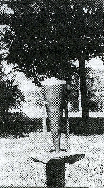
assigned to the same 1st Dragoons. However, so far as is known, he did not record the weather
after they moved to Sonoma.

     In November 1850, Dr John Campbell was added to the staff as an Assistant Surgeon. The
primary responsibility of the surgeon was the physical welfare of the troops but he also was
responsible for making weather observations. To the long list of historic firsts in Sonoma, Dr
Campbell added another — the first weather observations in Sonoma. He entered his
observations on the U.S. Army Form 2 Meteorological Register and, at the end of the November
1850, he forwarded it (Figure 1) to the Surgeon General’s Office in Washington.

Figure 1. First Weather Observations from Sonoma, November 1850
Source: National Climatic Data Center

     Weather observation made by the Post Surgeon was not a new idea. The Army Surgeon
General, Joseph Lovell, had initiated efforts to create a climate network in 1817. By 1819, the
network was collecting daily weather observations from Army Posts located in the then 22 states.
The observers in that network were the Surgeons at the Posts. Their reports were forwarded to
the Surgeon General’s office in Washington. Surgeon General Lovell stated clearly that the
purpose of the network was to determine if climate change was then occurring.

                                                                                                2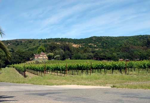
On the question whether in a series of years there be any material
               change in the climate of a given district of country; and if so, how
               far it depends upon cultivation of the soil, density of population,
               &c, the most contradictory opinions have been advanced. While
               one contends, that as population increases and cultivation extends
               the climate becomes warmer, another is equally convinced that it
               becomes colder and a third, that there is no change in this respect.

      Before any determination about climate change could be made, a base line of data had to be
collected. It was essential that those data be collected before the “natural” climate was altered by
the intrusion of human activities. Surgeon General Lawson noted in 1840 that the place to do that
was on the frontier.

               ….the hope is indulged that the medical corps of the army, more
               especially as many of the military posts afford an opportunity of
               making observations in regions still in a state of nature, will ere
               long be furnished with the means of prosecuting more extensive
               researches, and of keeping pace with the progress of Science.

Location

       Sonoma was incorporated in 1850 and was the original county seat of Sonoma County. The
first location for all observations made by the Army in 1850 and 1851 was at the Sonoma
Barracks on the Plaza in Sonoma. The second location was at the residence and ranch of Robert
Hall beginning from 1882 and continuing to 1911. The Hall Ranch was primarily orchards
located along the Sonoma Creek (Figure 2).

                                                                                                  3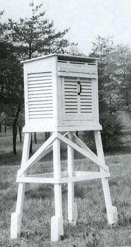
Figure 2. Looking North along Sonoma Creek
     Source: Depot Park Museum, Sonoma

     In addition to Robert Hall’s observations, rainfall measurements were made at the
Gundlach-Brundshu Winery from September 1909 through March 1911. The disposition of those
records is unknown.

      After 1911, observations were not resumed until 1951 when Lawrence W. Dickey became
the observer at his home in Sonoma for the Weather Bureau.

Record

     The Army’s weather record at Sonoma continued until they abandoned the location. There
followed an eleven-year period of time without weather observations being taken in any official
network. In October 1862, observations resumed for a five-month period. Almost twenty years
followed after that with no observational record.

     When observations were resumed in July 1882, the location of the observation site had
changed only slightly. The recipient of the data had changed. The U.S. Army’s Signal Service

                                                                                                  4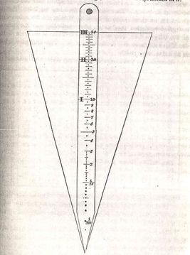
was created in 1871 by Congress to organize and operate a climate network. It began with fifty-
two weather stations but by 1884 received data from 458 weather stations, one of which was a
Voluntary Observer Station at Sonoma.

     The Sonoma station contributed to contribute to the climate record until 1911. The
observations ended and were not begun again until 1951.

      During the entire period of record, the growth of the town did not spawn the urbanization
that would have contaminated the record with the heat that large cities generate. Even with the
breaks in the record, it represents an important location for studies of long-term climate
variability.

Goal of the Study

      The goal of this study was to document the weather observational history of Sonoma,
California. The climatic data, and information from the observations made there, are readily
available for the entire period of record. They may be accessed through the National Climatic
Data Center, the Western Regional Climate Center, and the State Climatologist of California.
The challenge of this study was to identify the role of Sonoma in the development of a federal
weather observational program and where it fit in the route that followed from the Army
Surgeons, the Signal Service Observers, and the Weather Bureau meteorologists, to the current
National Weather Service Forecasters and their extensive observational and forecast network of
today.

                                                                                                  5
LOCATION OF OBSERVATIONS
Surgeon General Years 1850-1851
The first observations were made at Sonoma Barracks. The barracks (Figures 3 and 4) was
located on the northwest corner of the intersection of 1st and Spain Streets facing the Sonoma
Plaza.
Figure 3. Sonoma Barracks, 2006
Source: Author
Sonoma Sonoma
Barracks Mission
Figure 4. Sonoma Barracks 1873
Source: Menefee, 1873
6The original Barracks was constructed to house Mexican soldiers under General Vallejo in
1840-1841. It was used for that purpose until 1844. Tays included a description of the Barracks
and the other structures on the north side of the Plaza.
Vallejo’s building and premises which occupied an entire block of
almost six hundred feet facing the plaza on its north side. At the
east end of the block was the two-story adobe barracks, 110 feet
long and 50 feet wide. The eastern half of the barracks, contained a
large assembly hall 52 feet long and 45 feet wide; and along the
front of the second story was a five –foot balcony extending the
full length of the building. A high adobe wall about 25 feet long,
with a wide gate, connected the western end of the barracks with
the eastern end of the General’s home. Vallejo’s mansion was also
a two-story adobe, in the form of an L. The main wing, about 130
feet long, faced south and, like the barracks, had a balcony along
the front. The other wing projected from the west end toward the
north, and was about 100 feet long, both wings being 50 feet wide.
At the western corner formed by the intersection of the wings, rose
a square tower four stories high, and around each of the three
upper stories was a narrow balcony used by the sentries on guard.
Another high adobe wall, 150 feet long,, in which was a wide gate,
connected the west side of the tower with the east end of Salvador
Vallejo’s home, which stood at the western end of the block.
Across the street, east of the barracks, stood the church and
mission buildings of San Francisco Solano.
A part of the U.S. Army’s 7th New York Volunteers2 were the first U.S. Army unit to be
stationed in Sonoma. About 1,000 men of that unit came to California from New York by ship
on a trip that took them around the Horn. A small company of them reported, in their Return for
the month, that they had arrived in Sonoma from San Francisco on 4 April 1847 and had
occupied the Barracks.
When they arrived, they had a hospital steward but did not have a surgeon assigned. The
responsibility for making weather observations was assigned by the Army Surgeon General to
the surgeons. Because no surgeon was present, the presumption is that no meteorological
instruments were available to the steward who was a Private.
2
Known as Stephenson’s Regiment
7The 1st Dragoons, who had endured Kearney’s trek from Santa Fe to California, moved into
Sonoma on 3 May 1849 and replaced the New York men. This replacement unit was commanded
by Captain Andrew. J. Smith3. They did not make weather observations.
Dr Campbell of the 1st Dragoons arrived in November 1850 with his weather instruments
and immediately began to make observations. The location of the meteorological instruments
was recorded as 38˚ 16' 54" N and 122˚ 20' 40" W. The method for determining the location was
not recorded. Even so, one can estimate their location because the instructions required the
thermometer to be mounted on the north side of a building, preferably in continual shade under
an overhanging roof. The Barracks had an overhanging roof (Figure 5) that sheltered the north
side of the building It seems likely the thermometer would have been hanging on the first floor
wall that faced the courtyard.
Figure 5. Courtyard in Read of Sonoma Barracks
Source: Author, 2006
The Global Positioning System (GPS) location of the estimated location was 38˚ 17' 40" N
and 122˚ 27' 24" W at an elevation of about 84 feet above mean sea level (MSL).
The Army Post in Sonoma was closed in January 1852 according to Parmelee. He stated
that the surplus blankets, leather goods, furniture and uniforms were sold to the local citizens.
3
A. J. Smith would become a Major General in the Confederate Army during the Civil War
8The Signal Service Years 1882-1892
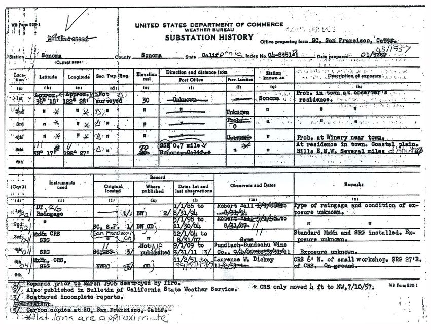
The observations resumed in 1882. As in the previous description of location, this one’s
precise location was not recorded. It was just given as being at Sonoma. The Form 530-1
Substation History for Sonoma prepared by the Weather Bureau on 1 January 19574 (Figure 6)
approximates the location as 38˚ 18' N and 122˚ 28' W at an elevation of 30 feet MSL There was
the caveat that it was not a surveyed position and was probably at the observer’s residence.5
Figure 6. Substation History Form 530 for Sonoma, 1957
Source: National Climatic Data Center
4
Note that the handwritten entries on the form were editorial comments made three months after
the original. No substantive changes were made.
5
This residence may be the one Mr. Hall used while his home on the ranch was being built.
9The second series of observations were made at Hall’s Ranch. The Ranch lay in the
floodplain of Sonoma Creek (Figure 7) with little variation in altitude from the previous
observations site.
Sonoma
Barracks
Broadway
Hall Ranch
Figure 7. Hall Ranch Location
Source: On left, Historical Map of Sonoma County California, 1877.
On Right, USGS Orthophoto Image, 1998
10At the ranch, the home (Figure 8) was one possible location of the observations.
Figure 8. Robert Hall’s Residence
Source: Depot Park Museum, Sonoma Valley Historical Society
The area in the foreground of Figure 8 may be the courtyard mentioned as the observation
location.
The observer noted temperatures six times on the morning of the 30th in his March 1884
report. The temperature had reached 32˚ at 2 o’clock that morning and smoke was being
generated in his orchard because the trees were in bloom. Perhaps, the orchard (Figure 9) was
another place for temperature observations during the frost potential time of the year.
11Figure 9. Robert Hall’s Barn and Orchard, looking south
Source: Depot Park Museum, Sonoma Valley Historical Society
In April 1886, the location was reported at as 38˚ 17 2/3' N and 122˚ 26 1/2' W. Again,
there was no comment on how that location was determined.
Weather Bureau Years 1892—1911
The weather network was removed from the Signal Service and incorporated into the newly
created Weather Bureau in 1892. The only change at Sonoma was that data were then forwarded
to the Weather Bureau in Sacramento.
In a 1906 inspection report (Figure 10), the location was given more precisely at 38˚ 17'
40" N and 122˚ 26' 30" W. There is the note that it was two miles south of Sonoma in a level
valley of Sonoma Creek. That location was on the observer’s ranch “200 feet from residence”
and in the “N. E. Cor. Open court under veranda.” Compare that description to the photograph in
shown Figure 8.
12Figure 10. Description of Sonoma Station in 1906
Source: National Climatic Data Center
The confusion about the location was partially explained by a note the observer made on
his January 1883 report.
Having a city residence and a country home my report is irregular
— being in San Francisco in the winter mostly
13According to the Substation History (Figure 6), there were rainfall measurements taken at
the Gundlach-Bundschu Winery (Figure 11) near Sonoma from September 1909 through March
1911. It did not have the latitude or longitude for the observation site. Officials currently at the
Winery were unaware of these observations and had no record on where they might have been
taken. Assuming that the primary interest was the amount of rainfall that the vineyard received
and that it would not be far removed from the residence, a location was estimated by the author
and measured by GPS as 38˚ 16' 41" N and 122˚ 25' 08" W at approximately 94 feet MSL.
Figure 11. Gundlach-Bundschu Vineyard
Source: Author, 2006
The observations in Sonoma ended in August 1907 and did not resume until after the end
of the period for this paper. In November 1951, Lawrence W. Dickey established a station at his
residence at 394 East McArthur in Sonoma.
14INSTRUMENTATION
Thermometer
The only instruments that accompanied the surgeons to Sonoma in 1850 were a
thermometer to measure temperature, a weather vane to determine wind direction, and a rain
gauge to measure precipitation. Those were the standard instruments provided in the Surgeon
General’s climate network.
A detached thermometer used from 1886 through 1894 but its type was not recorded. The
maximum thermometer was number 10559 and the minimum was number 7964. Their use began
on 1 December 1904. The types of thermometers used at Sonoma were not recorded but they
probably were Green thermometers on Townsend mounts, the common equipment for the period.
An example of them is shown in Figure 11. They were mounted inside a shelter.
Figure 11. Green Maximum and Minimum Thermometers
Source: National Archives and Records Administration
Hygrometer
The first relative humidity entries were made for few days in November 1882. No mention
was made of the type of instrument being used.
The observer reported receiving wet and dry bulb thermometers and began reporting their
data in September 1885.
15Rain Gauge
The type of rain gauge used by the Army in Sonoma in 1850 was not recorded. However,
the Surgeon General’s instructions from 1855 gave a fairly vivid description.
The instrument used to measure the quantity of rain which falls is
the conical rain gauge.
I will be kept remote from all elevated structures, at a distance of at
least equal to their height, and still further off, where it can be
conveniently done. It is to be suspended in a circular opening made
in a board, which is to be fixed to a post, eight feet from the
ground; the opening to be five inches in diameter, and beveled so
as to fit the side of the gauge, into which the cap is to be fixed,
base downwards, to prevent evaporation. The measurement is
made by putting down perpendicularly to the bottom of the gauge
the measuring stick, and applying it, from its point to the water
mark, on the scale, which will express the quantity in inches, or
their decimals. The graduation of the scale is by hundredths of an
inch for the first three tenths of an inch, and above that by tenths
and half tenths. Parts of degrees will be measured by the eye, and
set down in decimals. If a rain continue for any length of time, the
quantity on the gauge will be measured at suitable intervals, before
the water rises high in it, and the measurements summed us at the
close.
Figure 12. DeWitt Conical Rain Gauge
Source: Silliman’s American Journal of Science and Art, 1832
16When the second observer began his record, he did not have a rain gauge. In his November
1882 report, the observer noted. “ I have no rain gauge but want one.”
He did not have his wish granted until much later. He occasionally made comments about
rainfall events but did not enter quantities. His first entries of rainfall amounts were on the form
he submitted for November 1885. That month gave him frequent opportunities with 13.40 inches
of rain that fell on twenty of November’s days.
There was no mention of the type of rain gauge that made those measurements. No doubt
that the U.S. Signal Service furnished it. The conical rain gauge that was in standard use for
many years was probably the type used in Sonoma. That type is shown in Figure 13.
Figure 13. Conical Rain Gauge
Source: National Archives and Records Administration
17The standard U.S. Weather Bureau rain gauge (Figure 14) was in use in 1906.
Outer Collector
Cylinder Funnel
Measuring
Stick
Inner
Cylinder
Figure 14. Standard Eight Inch Rain Gauge
Source: National Archives and Records Administration
The funnel of standard rain gage was placed over the inner cylinder and directed the water into it.
The area of the top of the funnel was ten times the area of the top of the inner cylinder.
Therefore, an inch of rainfall would stand ten inches deep in the inner cylinder. The measuring
stick was magnified (in effect) ten times, to an actual length of twenty inches, and was marked in
rainfall inches and hundredths of an inch. The inner cylinder and funnel were placed into the
outer cylinder. The outer cylinder caught the overflow when the amount was greater than two
inches and could be used to catch snowfall in the winter.
Barometer
The first barometer entries were made on 1 February 1883 with no indication of the type of
barometer being used. The barometer had an “attached thermometer” that measured the room
temperature so that a correction could be made for the expansion of the mercury due to
temperature. That temperature was entered on the observation form.
18The Green Barometer was in widespread use by the Signal Service. It is probable that the
one in Sonoma was like the one shown in Figure 15.
Vernier
Attached
Thermometer
Mercury
Cistern
Figure 15. Mercury Barometer
Source: National Archives and Records Administration
Shelter
The thermometers were mounted inside an instrument shelter at the Hall Ranch. In 1906,
the shelter was located at the northeast corner of an open court under the veranda, ten feet wide,
19at about seven feet above ground. The door of the shelter faced west and the floor of the shelter
was four feet above ground level. The shelter was located 200 feet from the residence. The
shelter that was provided by the Weather Bureau to observers like Hall is shown in Figure 16.
Figure 16. Cotton Region Instrument Shelter was the Type Used in Sonoma
Source: National Archives and Records Administration
20Wind Instruments
Weather vanes6 were provided to some observers by the U.S. Signal Service. Direction of
the wind was observed in the sixteen points of the compass. The vane was to be mounted on a
roof and oriented to true north. It was to be mounted at least eight to ten feet higher than
surrounding obstacles. Figure 17 is one vane from that era.
View of
Vane from
Above
Figure 17. Weather Vane used by Signal Service Volunteer Observers
Source: Instructions to Volunteer Observers, 1882
6
Vanes were also called “weather cocks.”
21OBSERVERS
Surgeon General Years
Nov 1850 —Apr 1851
Dr John Campbell
John Campbell was the first weather observer in Sonoma. He was born in New York and
joined the Army on 13 December 1847 as an Assistant Surgeon. He arrived in Sonoma on 24
October 1850 for duty with the U.S. Army’s 1st Dragoons who were stationed there. His career in
the Army continued until his retirement on 16 September 1885 in the rank of Colonel.
Dr Campbell was also the second Army physician7 in Sonoma. He had been preceded by
Dr John S. Griffin who was with the Army in Los Angeles but also served at Sonoma as the
surgeon in Kearney’s 1st Dragoons.
According to Warren, the Surgeon General wrote to Dr Griffin on 11 September 1849.
…I may now add that Assistant Surgeon John Campbell and
Abbott (a late appointment) have been detailed for duty in
California and will proceed thither via Chagres8…
Warren also recounts a second letter from the Surgeon General on 6 June 1850, indicating
that he thought that Dr Campbell had arrived in California.
Dr Campbell reported his arrival in Panama on the 24th March and
doubtless reached California in April …
Regardless of that belief, Dr Campbell had not yet arrived at the time of the letter.
In July 1850, Dr Griffin was granted a “conditional leave of absence.” Dr Campbell arrived
in October.
Signal Service Years
Jul 1882—May 1892
Robert Hall
Robert Hall was a native of Massachusetts who came to San Francisco, California in
1863. He, along with his partner Robert Howe, developed an orchard just south of Sonoma in
7
The first physician in Sonoma was Dr Charles Van Geldern who arrived in 1849 according to
Veronda
8
The Chagres River was a river in Panama part of the route across the Isthmus from the
Caribbean to the Pacific
221872. They expanded their land holding until it was divided between the two in 1885. The Hall
Ranch by 1889 was described by Lewis as having 180 acres. His 80 acres of orchard grew a
variety of fruits including peach, apricot, pear, quince, plum, cherry, apples, prunes, nectarines,
figs, almonds, and walnuts. He also had 56 acres of wine grapes and five acres of table grapes.
The Santa Rosa and Carquinez Railroad passed through his ranch.
It may have been that his interest in weather derived from concern for the productivity of
his extensive orchards. In any case, he became a Voluntary Observer for the U.S. Signal Service
in July 1882.
Weather Bureau Years
Jun 1892— Aug 1907
Robert Hall
Robert Hall continued to observe and record the weather when the responsibilities of the
Signal Service were transferred to the Weather Bureau created within the Department of
Agriculture.
23OBSERVATIONS
Observations 1850-1851
The surgeon at Sonoma Barracks made observations at the times prescribed in the Surgeon
General’s directions for taking meteorological observations. They directed observations of
temperature, clearness of the sky, the direction and force of the wind, and the direction and
velocity of the clouds. They were to record the time of commencement and end of precipitation
with the amount rainfall as measured by the rain gauge.
The observations were made at “a little before sunrise,” 9 a.m., 3 p.m., and 9 p.m. The
observations made at sunrise and 3 p.m. were added and the sum was halved to determine the
mean daily temperature. That approximates the current method of adding the maximum and
minimum temperatures and halving them to determine the daily mean. The daily minimum
usually occurs just before sunrise and the maximum usually about 2 p.m. or so.
The cloud movement entries were restricted to the lowest layer of clouds. Directions were
recorded as the direction from which the clouds were moving. The velocity was estimated and
recorded as a number that represented a range of velocities.
Observations 1862-1863
There was a reference by the observer, Robert Hall, in his May 1883 report of the rainfall
was “unprecedented. The nearest approach to it was in May 1860 when it amounted to 2. 86
inches.” There is not an indication of who made the older observations but it may well have been
Hall.
Observations 1882-1892
The early observation forms submitted by observer Robert Hall were seldom complete. He
remarked about his absences, his business apparently required him to be away frequently.
Beginning in 1884, his forms were mostly complete, fewer missing days than previous forms.
There were still absences though. For example, he commented about these missing weeks.
Nov 6/84 Left Sonoma and remained at S.F. until March 2d/85.
During that interval no observations taken. // Hall
24When not absent, his forms were generally complete and contained remarks that were
informative about the weather. These remarks (Figure 18) discuss the unusually calm conditions
that prevailed through December 1885 and the effect that had on his orchard.
Figure 18. Robert Hall’s Remarks, December 1885
Source: National Climatic Data Center
Dry bulb and wet bulb temperatures were reported for the first time at 9 p.m, in September
1885. The dew point and relative humidity entries were not made perhaps he did not have the
tables necessary for that determination. The data were not entered again after March 1886.
The Signal Service form had ample space for remarks and instructions for what elements
deserved comments. In 1886, data were being collected on a variety of topics. We find some of
those topics to be far removed from meteorology. For example, the requirement to report aurora
borealis and earthquakes eventually disappeared from the topics. Others requirements are related
to weather and climate but may seem strange at first glance. One of those was the requirement to
report the temperature of well and spring water at least once each season. It turns out that ground
water temperature mimics the mean annual temperature and, although wasn’t the reason the data
were collected, is now a valuable artifact of climate. Other requirements such as the time of
budding, leafing, etc. were more directly related to what we understand weather to be. The list
(Figure 19) of the casual phenomena had a much wider scope of remarks than that solicited today
but still makes reading the old weather reports interesting.
25Figure 19. Instructions for Casual Phenomena from Observation Form
Source: National Climatic Data Center
The remarks from observer Hall (Figure 20) were confined, for the most part, to
phenomena that directly affected his orchard.
Figure 20. Robert Hall’s Remarks March 1886
Source: National Climatic Data Center
26Observations 1892—1911
The observer commented in May 1892 on having difficulty completing the Weather
Bureau’s Form 1005.
The Weather Bureau form required the wind velocity to be entered as a “Force Number.”
Instructions for ascertaining velocity were printed on the form. The wind velocity was estimated
using words that had been assigned meanings in miles per hour.
Calm 0 mph
Very Gentle Breeze 2 mph
Gentle Breeze 4 mph
Fresh Breeze 12 mph
Strong Wind 25 mph
High Wind 35 mph
Gale 45 mph
Strong Gale 60 mph
Violent Gale 75 mph
Hurricane9 90 mph
In October 1892, the observer changed the observation hours from 7 a.m., 2 p.m. and 9
p.m. to 6 a.m., noon, and 6 p.m. He explained, “Am now rushed with clerical work during
vintage season, will furnish better report next month if you will provide me Blank Form No
1008...” The following month, his time of observations changed to 7 a.m., noon, and 5 p.m.
Digital Record
The National Climatic Data Center assigned station numbers to each of the climate stations
to facilitate the use of their data in digital from. The number assigned to Sonoma is 048351. The
same number is used with the observations made from November 1951 to the present.
9
The word “Hurricane” referred only to wind speed, not to the tropical cyclone we now
associate with it.
27CLIMATOLOGY
The Sonoma Democrat on 6 December 1873 published a letter to the editor about a snow
storm in Healdsburg.
Yesterday we had the heaviest snow storm that was ever known in
this part of the country, covering the whole face of the earth with
snow to a depth of five or six inches; rain setting in this morning
and rained all day, melting the snow and flooding the ground with
water, making the rainfall for the season six and forty-five
hundredths inches. The snow did more or less damage, the roofs of
houses falling in, trees falling on fences and breaking the telegraph
wires, but no lives were lost as far as heard from.
On the same day, the Sonoma Democrat also reported that professor William B. Hardy of the
Pacific Methodist College in Santa Rosa would begin to provide weather summaries at the end of
each month. The great storm mentioned in the article was the snow storm that had just occurred.
They should be carefully preserved for future reference. The full
series for the year will be invaluable to those interested in keeping
a record of the weather. This report is fuller than is ordinarily
published and will on that account be more acceptable, owing to
the great interest manifested in everything relating to the great
storm.
Professor Hardy was a professor of physics and an observer for the Smithsonian
Institution’s climate network. He had submitted his first observations to them for the November
1873 and the following month had recorded the snow depth in Santa Rosa from the great storm
as 12 inches. He added a comment (Figure 21) to verify the unusual nature of the storm.
Figure 21. Hardy’s Comments about the Great Snow Storm 1873
Source: National Climatic Data Center
28Professor Hardy’s first monthly report to the newspaper was for January 1874 and included
the barometer, thermometer, and rain gauge readings for each day. It was published on 7
February 1874 (Figure 22).
Figure 22. Hardy’s First Report to the Sonoma Democrat, 7 February 1874
Source: Sonoma Democrat
29Hardy provided reports to the Smithsonian Institution from November 1873 through April 1874.
Thompson’s 1877 book on Sonoma County contained several pages of climate information,
He had annual precipitation totals from 1853-1876 but did not identify the source. 1889 Lewis
Illustrated History of Sonoma County had a summary of climate for the period 1853-1886. The
source of the data and its specific location was not recorded. It included annual rainfall for
Sonoma County that were identical to those of comparable years in Thompson’s book. The data
in both books were from the rainy season rather than for the calendar year. The early years’ data
appear to be from Santa Rosa, the later years from Petaluma. Those data are shown in Table 1.
Table 1. Annual Precipitation Sonoma County 1853-1886
Santa Rosa Petaluma
1853-54 29” 1876-77 13.15”
1854-55 30” 1877-78 39.24”
1855-56 25” 1878-79 20.83”
1856-57 25 1879-80 26.83”
1857-58 23” 1880-81 24.55”
1858-59 23” 1881-82 17.04”
1859-60 21” 1882-83 19.15”
1860-61 17” 1883+84 24.55”
1861-62 46” 1884-85 14.96”
1862-63 17” 1885-86 28.89”
1863-64 12”
1864-65 26”
1865-66 30”
1866-67 40”
1867-68 50”
1868-69 26”
1869-70 25”
1870-71 17
1871-72 40”
1872-73 21.58”
1873-74 29.54
1874-75 23.30”
1875-76 >32”
1875-76 >32”
The U.S. Signal Service had replaced the Smithsonian as the climate network by the time
May Howard of Healdsburg began observing the weather for several months in 1878 beginning
in April. The record is short but good.
30The 1880 History of Sonoma County by Munro-Frazer detailed a discussion of Sonoma
County’s climate of each month quoted from the work of R. A. Thompson. It mentions the very
dry years of 1863-4 and 1864-5.
After a gap in the record, observations resumed in Santa Rosa in June 1885 by L. M. King.
He submitted his observations to the U.S. Signal Service. King’s contributions ended in August
1885. After a short gap in the record, A. C. McMeans was the Voluntary Observer for the Signal
Service in October 1887, but for that month only.
Extensive climatologies of California were prepared by James A. Barwick each year from
1887 through 1896. They were titled “Annual Meteorological Review of the State of California.”
Barwick was the meteorologist in charge of the Weather Bureau Office in Sacramento and was
hear of the Meteorological Department of the State Agricultural Society, also located in
Sacramento. He included temperature and precipitation tables that were provided by Robert Hall,
the observer in Sonoma.
The 1889 Lewis Illustrated History of Sonoma County had a summary of climate (pages
218-219) for the period 1853-1886. The source of the data and its specific location was not
recorded. It included annual rainfall for Sonoma County was included. The data were from the
rainy season rather than for the calendar year.
McAdie’s Climatology of California in 1903, included Sonoma’s monthly precipitation
data from 1886 through 1900.
Elford’s Climate of Sonoma County summarized the data from 1954 to 1964 for Sonoma
and gave the location as 38˚ 17’ N and 122 ˚7’ W at an elevation of 20 feet. Pages 2 through 5
are narrative summaries of the county’s climate. It also listed the climate stations in the county
with Pt Arena having a 50 year temperature record, several stations with 30 year records
including Santa Rosa, and Sonoma with a 10 year record. The narrative description of the
southeastern portion of the County includes a mention of Sonoma Creek that flows through the
valley into San Pablo Bay.
31APPENDIX 1
Methodology
The primary sources of information for this study were the Sonoma observers’ daily
weather records themselves. Copies of their monthly reports and the data digitized from
those reports were available from the Western Regional Climate Center in Reno, Nevada, or
the National Climatic Data Center in Asheville, North Carolina. The monthly reports can be
considered original sources because they were written by the observers and not altered by
subsequent readers.
There were a variety of secondary sources that held information about Sonoma, its
history, and its people. The author visited and collected information from the holdings of the
Sonoma Public Library and the Depot Park Museum in Sonoma; Sacramento Public
Library, California State Library; California State Archives, California Military Museum,
and the National Weather Service Office, Sacramento;. National Climatic Data Center at
Asheville, North Carolina; the National Archives and Records Administration, the National
Medical Library, and the Smithsonian Institution Archives in Washington, D.C.
The tertiary sources were reference materials that are available on-line. Among those
were the metadata prepared by the Office of the State Climatologist of California, the
Western Regional Climate Center, the National Climatic Data Center substation histories,
and the Office of Medical History in the Office of the Surgeon General, U.S. Army. Two
genealogical research sources, Ancestry.com and Genealogy.com were used to provide
some of the personal information about the observers. For location analysis, the interactive
maps available from TopoZone.com were used.
There was an attempt to glean information from all these sources that would allow a
glimpse into the lives of the observers, the location of the observation site, and the historical
environment that produced the climatic history of Sonoma. Maps, drawings, and
photographs were included when appropriate to illustrate the information.
Throughout the research for and preparation of this study, the objective was to produce
a document that future studies can use to evaluate the validity of the data that were collected
here, judge the trustworthiness of the observers who collected them, and determine the
climatological significance of the whatever variability may be discerned.
32BIBLIOGRAPHY
Alexander, James, 1986. Sonoma Valley Legacy; Histories and Sites of 70 Historic Adobes in
and around Sonoma Valley. Sonoma Valley Historical Society, Santa Rosa, California
Barwick, James A., 1887 through 1896. Annual Meteorological Review of the State of
California. Meteorological Department of the State Agricultural Society, Sacramento,
California
Bell and Heymans, 1888. Sonoma County and the Russian River Valley, Illustrated. Bell and
Heymans, San Francisco
Brown, Madie, 1961. California’s Valley of the Moon, Historic Places and People in the Valley
of Sonoma. Madie D. Brown, Sonoma, California
California Historical Society Quarterly, 1924. Letter from John B. Montgomery Commander,
USS Portsmouth, San Francisco to Vice Consul William A. Liedesdorff at Yerba Buena.
July 1846. Vol 2 No 4, Jan 1924 p. 357
Capron, E. S., 1854. History of California. John P. Jewett Company, Boston
Cooper, Edna.Scrapbook, Undated. Newspaper Pictures and Clippings of Sonoma. Held by the
Sonoma County Library, Santa Rosa, California
Elford, C. Robert, 1964. Climate of Sonoma County. U.S. Department of Commerce, Weather
Bureau, Washington
Elford, C. Robert,1970. Climate of California. Environmental Data Service, U.S. Dept. of
Commerce, Silver Spring, Maryland
Finley, Ernest Latimer, 1938. History of Sonoma County, California: Its People And Its
Resources. Press Democrat Publishing Company, Santa Rosa, California
Frazer, Robert W., 1980. Forts of The West : Military Forts And Presidios, and Posts Commonly
Called Forts, West of the Mississippi River to 1898. University of Oklahoma Press,
Norman, Oklahoma
French, Gerald L., 2001. Sonoma. Gerald L. French, Sonoma, California
Gerrish, Samuel H., 1885. Scrapbook of Climatological Clippings 1861-1885. Held in Rare
Books, California State Library, Sacramento, California
Gregory, Tom, 1911. History of Sonoma County, California : with biographical sketches of the
leading men and women of the county, who have been identified with its growth and development
from the early days to the present time. Historic Record Company, Los Angeles
33Guinn, James M., 1902. Historical and Biographical Record of Southern California : containing
a history of southern California from its earliest settlement to the opening year of the
twentieth century : also containing biographies of well-know citizens of the past and
present. Chapman Publishing Company, Chicago
Hall, William Hammond, 1886. Physical Data and Statistics of California. California State
Engineer, State Printer, Sacramento, 547 pages
Hansen, Harvey J and Jeanne T. Miller, 1962. Wild Oats in Eden: Sonoma County in the 19th
Century. Hooper Printing and Lithograph Company, Santa Rosa, California
Harlow, Neal, 1982. California Conquered. University of California Press, Berkeley, California
Hart, Herbert M., 1965. Old forts of the Far West. Superior Publishing Company, Seattle,
Washington
Heitman, Francis B., 1903. Historical Register and Dictionary of the U.S. Army 1789-1903.
Government Printing Office, Washington D. C.
Herman, Audrey and Denise Kruse, Virginia McLaren, 1996. Treasures of the Sonoma County
Library Photographical Collection. Sonoma County Library, Santa Rosa, California
Hughes, Patrick, 1970. A Century of Weather Service; A History Of The Birth And Growth Of
The National Weather Service, 1870-1970. Gordon and Breach, New York
Hunt, Rockwell D., 1932. California and Californians. Volumes 3 and 4. The Lewis Publishing
Company, Chicago
Lawson, Th, 1844. Directions for taking Meteorological Observations adopted by the Medical
Department of the United States Army. Surgeon General’s Office, Washington, DC
Lawson, T., 1855. Army Meteorological Register for Twelve Years, 1843-1854. Part VI ff.
Surgeon General’s Office, Philadelphia
Lewis Publishing Company, 1889. An Illustrated History of Sonoma County, California. The
Lewis Publishing Company, Chicago
Lynch, Robert M., 1997. The Sonoma Valley Story, Pages through the Ages, Sonoma Index-
Tribune. Sonoma, California
Mansfield, Joseph K. F., 1963. Mansfield on the Condition of the Western Forts, 1853-54. Edited
and with an introduction by Robert W. Frazer. University of Oklahoma Press reprint,
Norman, Oklahoma
Mathes, Valerie S. and Diane M. Smith, 2004. Images of Sonoma Valley. Arcadia Publishing,
Chicago
34McAdie, Alexander G., 1903. Climatology of California. Bulletin L, Weather Bureau, U.S.
Department of Agriculture, Government Printing Office, Washington
McKenney and Company, 1885-1886. 8 County Directory of Humboldt, Marin, Napa, Yolo,
Lake, Solano, Mendocino, and Sonoma Counties. L. M. McKenney And Company, San
Francisco
McKenney and Company, 1884. 8-County Cirectory of Sonoma, Napa, Lake, Mendocino,
Humboldt, Yolo, Solano, and Marin Counties, giving name, occupation, and residence of
all adult persons in the cities and towns 1884-5. L. M. McKenney And Company, San
Francisco
Menefee, C. A., 1873. Historical and Descriptive Sketch Book of Napa, Sonoma, Lake and
Mendocino Counties. Reporter Publishing House, Napa, California
Miller, Eric R., 1931. The Evolution of Meteorological Institutions in the United States. Monthly
Weather Review, Vol. 59, No. 1, January 1931
Munk, Joseph A., 1896. The Climate of Southern California. Reprint from California Medical
Journal December 1896. In Pamphlets on Meteorology held by California State Library
Munro-Fraser, J. P., 1880. History of Sonoma County : including its geology, topography,
mountains valleys and streams; with a full and particular record of the Spanish grants; its
early history and settlement. Alley, Bowen & Company, San Francisco
Murphy, Celeste Granice, 1937. The People of the Pueblo: or the Story of Sonoma. Binfords &
Mort, Portland, Oregon
O’Farrell, Jasper, 1850, Map of Sonoma, 1850. William H. Ranlett & Company, New York
Owenby, James R. and D. S. Ezell, 1992. Monthly Station Normals of Temperature,
Precipitation, and Heating and Cooling Degree Days 1961-1990. National Climatic Data
Center, U.S. Department of Commerce, Asheville, North Carolina
Parmelee, Robert D., 1972. Pioneer Sonoma. Sonoma Index-Tribune, Sonoma, California
Peninou, Ernest P., 1998. History of the Sonoma Vitaculture District. Nomis Press, Santa Rosa,
California
Phelps, Alonzo, 1881. Contemporary Biography of California’s Representative Men. A. L.
Bancroft and Company, San Francisco
Reynolds and Proctor Publishers, 1898. Illustrated Atlas of Sonoma County, California Compiled
and Published from Personal Examinations, Official Records and Actual Surveys. Santa
Rosa, California, Reprinted by Windmill Publications, Mt. Vernon, Indiana 1998
35San Francisco Evening Bulletin, 1878. California Climate, What the Meteorological Records of
the Railroad Companies Show. 25 January 1978, San Francisco
Sherman, William T., 1875. Memoirs of Gen. William T. Sherman. D. Appleton and Company,
New York (page 92)
Signal Service History, National Oceanic and Atmospheric Administration
http://www.history.noaa.gov/stories_tales/signal.html
Signal Service, 1882. Instructions for Voluntary Observers of the Signal Service United States
Army. Government Printing Office, Washington
Signal Service, 1884. History of the Signal Service. Government Printing Office, Washington
Smilie, Robert S, 1975. The Sonoma Mission, San Francisco Solano de Sonoma : the founding,
ruin and restoration of California's 21st mission. Valley Publishers, Fresno, California
Sonoma County Genealogical Society, 1995. 1890 Census Sonoma County California
Reconstructed. Santa Rosa, California
Sonoma County Historical Society Journal, Vol 1, No 3, June 1963, page 12
Sonoma Historical Society, 1968. Saga of Sonoma in the Valley of the Moon. Published by The
Sonoma Index-Tribune, Sonoma, California
Sonoma Index-Tribune, 1946. Centennial Edition, 1846-1946, Number, Vol. LXVII, No. 46. 7
June 1946. Sonoma, California
Sonoma Index-Tribune, 1973. Sonoma Mission Sesquicentennial Celebration, 1823-1973;
program of events, visitors' guide, history of the mission; supplement to the Sonoma Index-
Tribune, May 24, 1973. Sonoma, California
Sonoma Valley Historical Society, 1968. Saga of Sonoma in the Valley of the Moon. Santa Rosa,
California
Southern Pacific Company, 1903. Map of California Illustrating Its Climatology, Comparative
area, and Rail Lines. Passenger Department, Southern Pacific Company, San Francisco.
Held by California State Library
Surgeon General, 1868. General Meteorological Instructions. U.S. Army Surgeon General’s
Office, Washington DC
Tays, George, 1938. Mariano Guadalupe Vallejo and Sonoma. California Historical Society
Quarterly, Vol. 27 No. 2, June 1938
36The Sonoma Democrat, 1874. Meteorological. 7 February 1874, page 5, Santa Rosa, California
Thompson And West, 1877. Historical Atlas Map of Sonoma County, California / compiled,
Drawn & Published from Personal Examinations & Actual Surveys. Thompson and West.
Oakland, California
Thompson, Robert A., 1877. Historical and Descriptive Sketch of Sonoma County, California.
L. H. Everts and Company, Philadelphia
Thompson, Robert A., 1884. Central Sonoma : A Brief Description Of The Township And Town
Of Santa Rosa, Sonoma County, California : Its Climate And Resources.
Thompson, Robert A., 1889. An History of Sonoma County, California. The Lewis Publishing
Company, Chicago
Thompson, Thomas H., 1877. Atlas of Sonoma County, California with Illustrations.Thomas H.
Tompson and Company, Oakland California
Treganza, Adan E., 1956. Sonoma Mission : an Archaeological Reconstruction of the Mission
San Francisco de Solano quadrangle. Kroeber Anthropological Society, Berkeley,
California
Tuomey, Honoria and Luisa Vallejo Emparan, 1923. History of the Mission, Presidio and Pueblo
of Sonoma. California
Tuomey, Honoria, 1926. History of Sonoma County, California, Volumes 1 and 2.. S. J. Clarke
Publishing Company, Chicago
United States Army, 1847-1851. Returns from U.S. Military Posts, 1800-1916; Microfilm Roll
1204, Sonoma County April 1847-Dec 1851. Microfilm Held by the Sonoma County
Library, Santa Rosa, California
United States Department of Agriculture, 1897. Climate and Crop Service of the Weather
Bureau, California Section. Vol. I, No. 1, January 1897, U.S. Weather Bureau in
cooperation with the State Agricultural Society, Sacramento
United States War Department, 1885. General Order No. 25. Signal Service Office, Washington
United States Weather Bureau, 1905. Station Regulations. Weather Bureau, Government
Printing Office, Washington
Veronda, Charmaine B., 1879. History of Sonoma County, California. Alley Bowen and
Company, Oakland, California
Warner, Barbara R., 1976. The Bear Flag Party and Sonoma. Prepared for the California State
Department of Parks and Recreation.
37Warren, Viola L., 1955. Dr. John S. Griffin’s Mail, 1846-1853. Vol. 34, No. 1, California
Historical Society Quarterly, March 1955
Weber, Francis J., 1982. Last of the Missions : a Documentary History of San Francisco de
Solano. Libra Press Limited, Hong Kong
Weber, Gustavus Adolphous, 1922. The Weather Bureau; Its History, Activities And
Organization, D. Appleton and Company, New York
Whiting, J. S. and Richard J. Whiting, 1960. Forts of the State of California. Daily News Press,
Longview, Washington
Whitnah, Donald R. 1961. A History of the United States Weather Bureau. University of Illinois
Press, Urbana, Illinois
Wilson, Loren A., 2000. Fort Ross and Sonoma County. Cal150rnia Sesquicentennial,
Sebastopol, California
38You can also read